Bridge Statistics for San Bernardino, California (CA)
Condition, Traffic, Stress, Structural Evaluation, Project Costs
- National Bridge Inventory (NBI) Statistics
- 339Number of bridges
- 5,141ft / 1,567mTotal length
- $23,924,000Total costs
- 11,722,332Total average daily traffic
- 875,180Total average daily truck traffic
- National Bridge Inventory (NBI) Registered Bridges for San Bernardino
- No street view available for this location

- New bridges - historical statistics
- 21930-1939
- 111940-1949
- 311950-1959
- 931960-1969
- 341970-1979
- 341980-1989
- 281990-1999
- 272000-2009
- 792010-2019
- Reconstructed bridges - Historical Statistics
- 11940-1949
- 31950-1959
- 41960-1969
- 11970-1979
- 51980-1989
- 41990-1999
- 102000-2009
- 112010-2019
- Bridge Condition - Deck
- 58.2%Good
- 3.1%Satisfactory
- 32.5%Fair
- 6.2%Poor
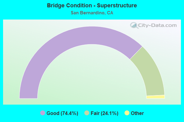
- Bridge Condition - Superstructure
- 74.4%Very good
- 24.1%Good
- 1.5%Satisfactory
- 24.1%Fair
- 0.5%Poor
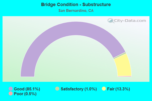
- Bridge Condition - Substructure
- 85.1%Good
- 1.0%Satisfactory
- 13.3%Fair
- 0.5%Poor
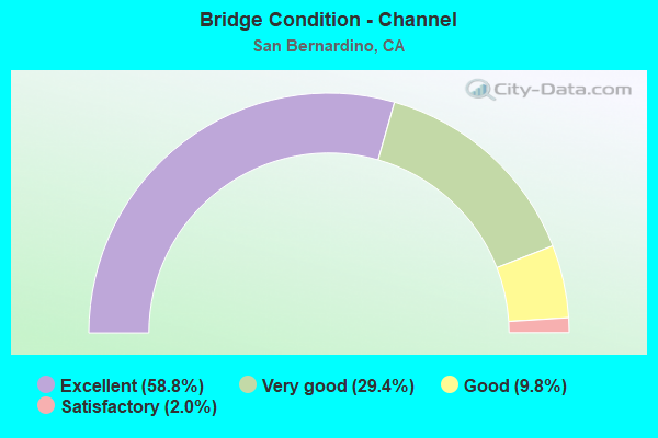
- Bridge Condition - Channel
- 58.8%Excellent
- 29.4%Very good
- 9.8%Good
- 2.0%Satisfactory
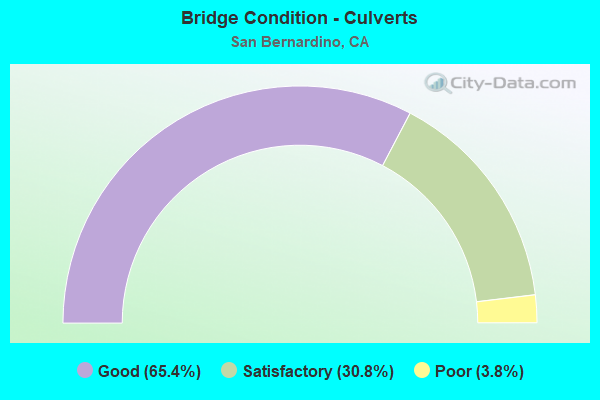
- Bridge Condition - Culverts
- 65.4%Good
- 30.8%Satisfactory
- 3.8%Poor
Find on map >> Show street view
Structure Number: 54 0826, Location: 08-SBD-210-20.19-SBD (Lat: 34.135125, Lng: -117.344544), Route carried "under" structure: State highway 210, Year Built: 1965, Structure Length: 0. m, Average Daily Traffic: 118,000 (year 2017), Truck Traffic: 7%, Features Intersected: STATE ROUTE 210, Facility Carried by Structure: UP RR
Minimum Vertical Clearance: 6.71m (22.01ft), Kilometerpoint: 20.190, Lanes under structure: 8, Material/Design: Steel, Design/Construction: Stringer/Multi-beam, Length of Maximum Span: 23.7m (77.8ft)
Find on map >> Show street view
Structure Number: 54 0943L, Location: 08-SBD-210-20.96-SBD (Lat: 34.135292, Lng: -117.331297), Route carried "under" structure: City street , Year Built: 2007, Structure Length: 0. m, Average Daily Traffic: 3,000 (year 2021), Truck Traffic: 5%, Features Intersected: CALIFORNIA STREET, Facility Carried by Structure: STATE ROUTE 210 WB
Minimum Vertical Clearance: 5.92m (19.42ft), Kilometerpoint: 0.000, Lanes on structure: 5, Lanes under structure: 2, Material/Design: Prestressed concrete, Design/Construction: Box Beam or Girders - Multiple, Length of Maximum Span: 38.5m (126.3ft)
Find on map >> Show street view
Structure Number: 54 0943R, Location: 08-SBD-210-20.96-SBD (Lat: 34.134969, Lng: -117.331289), Route carried "under" structure: City street , Year Built: 2007, Structure Length: 0. m, Average Daily Traffic: 3,000 (year 2021), Truck Traffic: 5%, Features Intersected: CALIFORNIA STREET, Facility Carried by Structure: STATE ROUTE 210 EB
Minimum Vertical Clearance: 7.31m (23.98ft), Kilometerpoint: 0.000, Lanes on structure: 5, Lanes under structure: 2, Material/Design: Prestressed concrete, Design/Construction: Box Beam or Girders - Multiple, Length of Maximum Span: 38.5m (126.3ft)
Find on map >> Show street view
Structure Number: 54 0944L, Location: 08-SBD-210-21.10-SBD (Lat: 34.135889, Lng: -117.329747), Route carried "under" structure: City street , Year Built: 2007, Structure Length: 0. m, Average Daily Traffic: 22,400 (year 2016), Truck Traffic: 5%, Features Intersected: HIGHLAND AVENUE, Facility Carried by Structure: STATE ROUTE 210 WB
Minimum Vertical Clearance: 5.00m (16.40ft), Kilometerpoint: 0.000, Lanes on structure: 5, Lanes under structure: 4, Material/Design: Prestressed concrete continuous, Design/Construction: Box Beam or Girders - Multiple, Length of Maximum Span: 55.5m (182.1ft)
Find on map >> Show street view
Structure Number: 54 0944R, Location: 08-SBD-210-21.10-SBD (Lat: 34.135856, Lng: -117.329061), Route carried "under" structure: City street , Year Built: 2007, Structure Length: 0. m, Average Daily Traffic: 22,400 (year 2016), Truck Traffic: 5%, Features Intersected: HIGHLAND AVENUE, Facility Carried by Structure: STATE ROUTE 210 EB
Minimum Vertical Clearance: 6.68m (21.92ft), Kilometerpoint: 0.000, Lanes on structure: 5, Lanes under structure: 4, Material/Design: Prestressed concrete continuous, Design/Construction: Box Beam or Girders - Multiple, Length of Maximum Span: 45.6m (149.6ft)
Find on map >> Show street view
Structure Number: 54 0946G, Location: 08-SBD-210-R21.72-SBD (Lat: 34.141928, Lng: -117.321167), Route carried "under" structure: City street , Year Built: 2012, Structure Length: 0. m, Average Daily Traffic: 3,900 (year 2017), Truck Traffic: 3%, Features Intersected: CAJON BLVD / BNSF RR, Facility Carried by Structure: E210-S215 CONNECTR
Minimum Vertical Clearance: 10.57m (34.68ft), Kilometerpoint: 0.000, Lanes on structure: 2, Lanes under structure: 2, Material/Design: Prestressed concrete continuous, Design/Construction: Box Beam or Girders - Multiple, Length of Maximum Span: 49.1m (161.1ft)
Find on map >> Show street view
Structure Number: 54 0946L, Location: 08-SBD-210-R21.72-SBD (Lat: 34.142744, Lng: -117.321875), Route carried "under" structure: City street , Year Built: 1989, Structure Length: 0. m, Average Daily Traffic: 3,900 (year 2017), Truck Traffic: 3%, Features Intersected: CAJON BLVD & BNSF RY, Facility Carried by Structure: STATE ROUTE 210 WB
Minimum Vertical Clearance: 9.19m (30.15ft), Kilometerpoint: 0.000, Lanes on structure: 4, Lanes under structure: 2, Material/Design: Prestressed concrete continuous, Design/Construction: Box Beam or Girders - Multiple, Length of Maximum Span: 42.7m (140.1ft)
Find on map >> Show street view
Structure Number: 54 0946R, Location: 08-SBD-210-R21.72-SBD (Lat: 34.142483, Lng: -117.321622), Route carried "under" structure: City street , Year Built: 1989, Structure Length: 0. m, Average Daily Traffic: 3,900 (year 2017), Truck Traffic: 3%, Features Intersected: CAJON BLVD & BNSF RY, Facility Carried by Structure: STATE ROUTE 210 EB
Minimum Vertical Clearance: 8.94m (29.33ft), Kilometerpoint: 0.000, Lanes on structure: 4, Lanes under structure: 2, Material/Design: Prestressed concrete continuous, Design/Construction: Box Beam or Girders - Multiple, Length of Maximum Span: 42.7m (140.1ft)
Find on map >> Show street view
Structure Number: 54 0947L, Location: 08-SBD-210-R21.84-SBD (Lat: 34.144308, Lng: -117.319811), Route carried "under" structure: Ramp Interstate 215, Year Built: 1989, Structure Length: 0. m, Average Daily Traffic: 1,001 (year 2011), Truck Traffic: 5%, Features Intersected: INTERSTATE 215 & RAMPS, Facility Carried by Structure: STATE ROUTE 210 WB
Minimum Vertical Clearance: 6.65m (21.82ft), Kilometerpoint: 10.050, Lanes on structure: 3, Lanes under structure: 1, Material/Design: Prestressed concrete continuous, Design/Construction: Box Beam or Girders - Multiple, Length of Maximum Span: 39.9m (130.9ft)
Find on map >> Show street view
Structure Number: 54 0947L, Location: 08-SBD-210-R21.84-SBD (Lat: 34.144308, Lng: -117.319811), Route carried "under" structure: Interstate 215, Year Built: 1989, Structure Length: 0. m, Average Daily Traffic: 69,500 (year 2017), Truck Traffic: 11%, Features Intersected: INTERSTATE 215 & RAMPS, Facility Carried by Structure: STATE ROUTE 210 WB
Minimum Vertical Clearance: 5.84m (19.16ft), Kilometerpoint: 10.050, Lanes on structure: 3, Lanes under structure: 7, Material/Design: Prestressed concrete continuous, Design/Construction: Box Beam or Girders - Multiple, Length of Maximum Span: 39.9m (130.9ft)
Find on map >> Show street view
Structure Number: 54 0947L, Location: 08-SBD-210-R21.84-SBD (Lat: 34.144308, Lng: -117.319811), Route carried "under" structure: Ramp State highway 210, Year Built: 1989, Structure Length: 0. m, Average Daily Traffic: 1,001 (year 2011), Truck Traffic: 5%, Features Intersected: INTERSTATE 215 & RAMPS
Minimum Vertical Clearance: 6.15m (20.18ft), Kilometerpoint: 21.880, Lanes on structure: 3, Lanes under structure: 1, Material/Design: Prestressed concrete continuous, Design/Construction: Box Beam or Girders - Multiple, Length of Maximum Span: 39.9m (130.9ft)
Find on map >> Show street view
Structure Number: 54 0947R, Location: 08-SBD-210-R21.84-SBD (Lat: 34.143986, Lng: -117.319617), Route carried "under" structure: Ramp State highway 210, Year Built: 1989, Structure Length: 0. m, Average Daily Traffic: 1,001 (year 2011), Truck Traffic: 5%, Features Intersected: INTERSTATE 215 & RAMPS
Minimum Vertical Clearance: 5.79m (19.00ft), Kilometerpoint: 21.840, Lanes on structure: 5, Lanes under structure: 1, Material/Design: Prestressed concrete continuous, Design/Construction: Box Beam or Girders - Multiple, Length of Maximum Span: 39.9m (130.9ft)
Find on map >> Show street view
Structure Number: 54 0947R, Location: 08-SBD-210-R21.84-SBD (Lat: 34.143986, Lng: -117.319617), Route carried "under" structure: Ramp Interstate 215, Year Built: 1989, Structure Length: 0. m, Average Daily Traffic: 1,001 (year 2013), Truck Traffic: 2%, Features Intersected: INTERSTATE 215 & RAMPS, Facility Carried by Structure: STATE ROUTE 210 EB
Minimum Vertical Clearance: 6.07m (19.91ft), Kilometerpoint: 0.000, Lanes on structure: 5, Lanes under structure: 1, Material/Design: Prestressed concrete continuous, Design/Construction: Box Beam or Girders - Multiple, Length of Maximum Span: 39.9m (130.9ft)
Find on map >> Show street view
Structure Number: 54 0947R, Location: 08-SBD-210-R21.84-SBD (Lat: 34.143986, Lng: -117.319617), Route carried "under" structure: Ramp Interstate 215, Year Built: 1989, Structure Length: 0. m, Average Daily Traffic: 1,000 (year 2013), Truck Traffic: 2%, Features Intersected: INTERSTATE 215 & RAMPS, Facility Carried by Structure: STATE ROUTE 210 EB
Minimum Vertical Clearance: 5.51m (18.08ft), Kilometerpoint: 0.000, Lanes on structure: 5, Lanes under structure: 1, Material/Design: Prestressed concrete continuous, Design/Construction: Box Beam or Girders - Multiple, Length of Maximum Span: 39.9m (130.9ft)
Find on map >> Show street view
Structure Number: 54 0947R, Location: 08-SBD-210-R21.84-SBD (Lat: 34.143986, Lng: -117.319617), Route carried "under" structure: Ramp Interstate 215, Year Built: 1989, Structure Length: 0. m, Average Daily Traffic: 1,001 (year 2011), Truck Traffic: 5%, Features Intersected: INTERSTATE 215 & RAMPS, Facility Carried by Structure: STATE ROUTE 210 EB
Minimum Vertical Clearance: 5.46m (17.91ft), Kilometerpoint: 10.050, Lanes on structure: 5, Lanes under structure: 1, Material/Design: Prestressed concrete continuous, Design/Construction: Box Beam or Girders - Multiple, Length of Maximum Span: 39.9m (130.9ft)
Find on map >> Show street view
Structure Number: 54 0947R, Location: 08-SBD-210-R21.84-SBD (Lat: 34.143986, Lng: -117.319617), Route carried "under" structure: Interstate 215, Year Built: 1989, Structure Length: 0. m, Average Daily Traffic: 69,500 (year 2017), Truck Traffic: 11%, Features Intersected: INTERSTATE 215 & RAMPS, Facility Carried by Structure: STATE ROUTE 210 EB
Minimum Vertical Clearance: 5.41m (17.75ft), Kilometerpoint: 10.050, Lanes on structure: 5, Lanes under structure: 6, Material/Design: Prestressed concrete continuous, Design/Construction: Box Beam or Girders - Multiple, Length of Maximum Span: 39.9m (130.9ft)
Find on map >> Show street view
Structure Number: 54 0948F, Location: 08-SBD-210-R21.97-SBD (Lat: 34.145797, Lng: -117.318036), Route carried "under" structure: City street , Year Built: 1989, Structure Length: 0. m, Average Daily Traffic: 7,000 (year 2017), Truck Traffic: 2%, Features Intersected: LITTLE MOUNTAIN DRIVE, Facility Carried by Structure: W210-N215 CONNECTR
Minimum Vertical Clearance: 6.63m (21.75ft), Kilometerpoint: 0.000, Lanes on structure: 1, Lanes under structure: 4, Material/Design: Prestressed concrete, Design/Construction: Box Beam or Girders - Multiple, Length of Maximum Span: 57.3m (188.0ft)
Find on map >> Show street view
Structure Number: 54 0948L, Location: 08-SBD-210-R21.97-SBD (Lat: 34.145222, Lng: -117.317739), Route carried "under" structure: City street , Year Built: 1989, Structure Length: 0. m, Average Daily Traffic: 7,000 (year 2017), Truck Traffic: 2%, Features Intersected: LITTLE MOUNTAIN DRIVE, Facility Carried by Structure: STATE ROUTE 210 WB
Minimum Vertical Clearance: 8.03m (26.35ft), Kilometerpoint: 0.000, Lanes on structure: 3, Lanes under structure: 4, Material/Design: Prestressed concrete, Design/Construction: Box Beam or Girders - Multiple, Length of Maximum Span: 48.8m (160.1ft)
Find on map >> Show street view
Structure Number: 54 0948R, Location: 08-SBD-210-R21.97-SBD (Lat: 34.144925, Lng: -117.317589), Route carried "under" structure: City street , Year Built: 1989, Structure Length: 0. m, Average Daily Traffic: 7,000 (year 2017), Truck Traffic: 2%, Features Intersected: LITTLE MOUNTAIN DRIVE, Facility Carried by Structure: STATE ROUTE 210 EB
Minimum Vertical Clearance: 7.77m (25.49ft), Kilometerpoint: 0.000, Lanes on structure: 4, Lanes under structure: 4, Material/Design: Prestressed concrete, Design/Construction: Box Beam or Girders - Multiple, Length of Maximum Span: 48.8m (160.1ft)
Find on map >> Show street view
Structure Number: 54 0950L, Location: 08-SBD-210-R22.55-SBD (Lat: 34.146036, Lng: -117.307922), Route carried "under" structure: State highway 210, Year Built: 1989, Structure Length: 0. m, Average Daily Traffic: 106,000 (year 2017), Truck Traffic: 6%, Features Intersected: STATE ROUTE 210, Facility Carried by Structure: MUSCUPIABE DR SB
Minimum Vertical Clearance: 5.23m (17.16ft), Kilometerpoint: 22.550, Lanes on structure: 1, Lanes under structure: 7, Material/Design: Prestressed concrete continuous, Design/Construction: Box Beam or Girders - Multiple, Length of Maximum Span: 37.2m (122.0ft)
Find on map >> Show street view
Structure Number: 54 0950R, Location: 08-SBD-210-R22.55-SBD (Lat: 34.146050, Lng: -117.307703), Route carried "under" structure: State highway 210, Year Built: 1989, Structure Length: 0. m, Average Daily Traffic: 106,000 (year 2017), Truck Traffic: 6%, Features Intersected: STATE ROUTE 210, Facility Carried by Structure: MUSCUPIABE DR NB
Minimum Vertical Clearance: 5.79m (19.00ft), Kilometerpoint: 22.550, Lanes on structure: 1, Lanes under structure: 7, Material/Design: Prestressed concrete continuous, Design/Construction: Box Beam or Girders - Multiple, Length of Maximum Span: 37.2m (122.0ft)
Find on map >> Show street view
Structure Number: 54 0952, Location: 08-SBD-210-R22.94-SBD (Lat: 34.146000, Lng: -117.300967), Route carried "under" structure: State highway 210, Year Built: 1989, Structure Length: 0. m, Average Daily Traffic: 111,000 (year 2017), Truck Traffic: 6%, Features Intersected: STATE ROUTE 210, Facility Carried by Structure: H STREET
Minimum Vertical Clearance: 5.15m (16.90ft), Kilometerpoint: 22.940, Lanes on structure: 4, Lanes under structure: 6, Material/Design: Prestressed concrete continuous, Design/Construction: Box Beam or Girders - Multiple, Length of Maximum Span: 33.8m (110.9ft)
Find on map >> Show street view
Structure Number: 54 1074L, Location: 08-SBD-210-R26.76-SBD (Lat: 34.136086, Lng: -117.236328), Route carried "under" structure: City street , Year Built: 1992, Structure Length: 0. m, Average Daily Traffic: 8,400 (year 2013), Truck Traffic: 2%, Features Intersected: HIGHLAND AVE & ARDEN AVE, Facility Carried by Structure: STATE ROUTE 210 WB
Minimum Vertical Clearance: 4.92m (16.14ft), Kilometerpoint: 0.000, Lanes on structure: 2, Lanes under structure: 6, Material/Design: Prestressed concrete continuous, Design/Construction: Box Beam or Girders - Multiple, Length of Maximum Span: 47.9m (157.2ft)
Find on map >> Show street view
Structure Number: 54 1074L, Location: 08-SBD-210-R26.76-SBD (Lat: 34.136086, Lng: -117.236328), Route carried "under" structure: City street , Year Built: 1992, Structure Length: 0. m, Average Daily Traffic: 27,000 (year 2012), Truck Traffic: 2%, Features Intersected: HIGHLAND AVE & ARDEN AVE, Facility Carried by Structure: STATE ROUTE 210 WB
Minimum Vertical Clearance: 5.08m (16.67ft), Kilometerpoint: 0.000, Lanes on structure: 2, Lanes under structure: 7, Material/Design: Prestressed concrete continuous, Design/Construction: Box Beam or Girders - Multiple, Length of Maximum Span: 47.9m (157.2ft)
Find on map >> Show street view
Structure Number: 54 1074R, Location: 08-SBD-210-R26.73-SBD (Lat: 34.136092, Lng: -117.237131), Route carried "under" structure: City street , Year Built: 1992, Structure Length: 0. m, Average Daily Traffic: 8,400 (year 2013), Truck Traffic: 2%, Features Intersected: HIGHLAND AVE & ARDEN AVE, Facility Carried by Structure: STATE ROUTE 210 EB
Minimum Vertical Clearance: 6.15m (20.18ft), Kilometerpoint: 0.000, Lanes on structure: 2, Lanes under structure: 6, Material/Design: Prestressed concrete continuous, Design/Construction: Box Beam or Girders - Multiple, Length of Maximum Span: 47.9m (157.2ft)
Find on map >> Show street view
Structure Number: 54 1074R, Location: 08-SBD-210-R26.73-SBD (Lat: 34.136092, Lng: -117.237131), Route carried "under" structure: City street , Year Built: 1992, Structure Length: 0. m, Average Daily Traffic: 27,000 (year 2012), Truck Traffic: 2%, Features Intersected: HIGHLAND AVE & ARDEN AVE, Facility Carried by Structure: STATE ROUTE 210 EB
Minimum Vertical Clearance: 6.10m (20.01ft), Kilometerpoint: 0.000, Lanes on structure: 2, Lanes under structure: 4, Material/Design: Prestressed concrete continuous, Design/Construction: Box Beam or Girders - Multiple, Length of Maximum Span: 47.9m (157.2ft)
Find on map >> Show street view
Structure Number: 54 1077, Location: 08-SBD-210-R27.90-SBD (Lat: 34.132300, Lng: -117.217644), Route carried "under" structure: State highway 210, Year Built: 1992, Structure Length: 0. m, Average Daily Traffic: 100,000 (year 2019), Truck Traffic: 7%, Features Intersected: STATE ROUTE 210, Facility Carried by Structure: CENTRAL AVENUE
Minimum Vertical Clearance: 5.16m (16.93ft), Kilometerpoint: 27.900, Lanes on structure: 2, Lanes under structure: 4, Material/Design: Prestressed concrete continuous, Design/Construction: Box Beam or Girders - Multiple, Length of Maximum Span: 33.8m (110.9ft)
Find on map >> Show street view
Structure Number: 54 1078, Location: 08-SBD-210-R28.40-SBD (Lat: 34.131892, Lng: -117.208892), Route carried "under" structure: State highway 210, Year Built: 1992, Structure Length: 0. m, Average Daily Traffic: 100,000 (year 2019), Truck Traffic: 7%, Features Intersected: STATE ROUTE 210, Facility Carried by Structure: PALM AVENUE
Minimum Vertical Clearance: 5.18m (16.99ft), Kilometerpoint: 28.400, Lanes on structure: 2, Lanes under structure: 5, Material/Design: Prestressed concrete continuous, Design/Construction: Box Beam or Girders - Multiple, Length of Maximum Span: 37.8m (124.0ft)
Find on map >> Show street view
Structure Number: 54 1088, Location: 08-SBD-210-R28.15-SBD (Lat: 34.132231, Lng: -117.213211), Route carried "under" structure: State highway 210, Year Built: 1992, Structure Length: 0. m, Average Daily Traffic: 100,000 (year 2019), Truck Traffic: 7%, Features Intersected: STATE ROUTE 210, Facility Carried by Structure: ORANGE STREET
Minimum Vertical Clearance: 5.03m (16.50ft), Kilometerpoint: 28.150, Lanes on structure: 2, Lanes under structure: 5, Material/Design: Prestressed concrete continuous, Design/Construction: Box Beam or Girders - Multiple, Length of Maximum Span: 34.4m (112.9ft)
Find on map >> Show street view
Structure Number: 54 1097F, Location: 08-SBD-330-R28.78-SBD (Lat: 34.129711, Lng: -117.203461), Route carried "under" structure: Ramp State highway 210, Year Built: 1993, Structure Length: 0. m, Average Daily Traffic: 10,000 (year 2020), Truck Traffic: 2%, Features Intersected: E210-N330 CONNECTOR RAMP
Minimum Vertical Clearance: 5.31m (17.42ft), Kilometerpoint: 28.720, Lanes on structure: 1, Lanes under structure: 2, Material/Design: Prestressed concrete, Design/Construction: Box Beam or Girders - Multiple, Length of Maximum Span: 34.4m (112.9ft)
Find on map >> Show street view
Structure Number: 54 1098F, Location: 08-SBD-330-R28.70-SBD (Lat: 34.127953, Lng: -117.203183), Route carried "under" structure: State highway 210, Year Built: 1992, Structure Length: 0. m, Average Daily Traffic: 72,000 (year 2017), Truck Traffic: 5%, Features Intersected: SR-210, PACIFIC AV POC
Minimum Vertical Clearance: 6.40m (21.00ft), Kilometerpoint: 28.760, Lanes on structure: 1, Lanes under structure: 4, Material/Design: Prestressed concrete continuous, Design/Construction: Box Beam or Girders - Multiple, Length of Maximum Span: 52.4m (171.9ft)
Find on map >> Show street view
Structure Number: 54 1100G, Location: 08-SBD-210-R28.66-SBD (Lat: 34.129914, Lng: -117.205758), Route carried "under" structure: State highway 210, Year Built: 1992, Structure Length: 0. m, Average Daily Traffic: 100,000 (year 2019), Truck Traffic: 7%, Features Intersected: STATE ROUTE 210
Minimum Vertical Clearance: 5.13m (16.83ft), Kilometerpoint: 28.660, Lanes on structure: 2, Lanes under structure: 4, Material/Design: Prestressed concrete continuous, Design/Construction: Box Beam or Girders - Multiple, Length of Maximum Span: 52.7m (172.9ft)
Find on map >> Show street view
Structure Number: 54 1221, Location: 08-SBD-215-9.71-SBD (Lat: 34.139542, Lng: -117.317028), Route carried "under" structure: Interstate 215, Year Built: 2011, Structure Length: 0. m, Average Daily Traffic: 92,000 (year 2019), Truck Traffic: 7%, Features Intersected: INTERSTATE 215, Facility Carried by Structure: 27TH STREET
Minimum Vertical Clearance: 6.53m (21.42ft), Kilometerpoint: 9.710, Lanes on structure: 3, Lanes under structure: 8, Material/Design: Concrete continuous, Design/Construction: Box Beam or Girders - Multiple, Length of Maximum Span: 36.3m (119.1ft)
Find on map >> Show street view
Structure Number: 54 1221, Location: 08-SBD-215-9.71-SBD (Lat: 34.139542, Lng: -117.317028), Route carried "under" structure: Ramp State highway 210, Year Built: 2011, Structure Length: 0. m, Average Daily Traffic: 1,001 (year 2013), Truck Traffic: 3%, Features Intersected: INTERSTATE 215, Facility Carried by Structure: 27TH STREET
Minimum Vertical Clearance: 8.66m (28.41ft), Kilometerpoint: 21.800, Lanes on structure: 3, Lanes under structure: 2, Material/Design: Concrete continuous, Design/Construction: Box Beam or Girders - Multiple, Length of Maximum Span: 36.3m (119.1ft)
Find on map >> Show street view
Structure Number: 54 1221, Location: 08-SBD-215-9.71-SBD (Lat: 34.139542, Lng: -117.317028), Route carried "under" structure: Ramp Interstate 215, Year Built: 2011, Structure Length: 0. m, Average Daily Traffic: 1,001 (year 2013), Truck Traffic: 2%, Features Intersected: INTERSTATE 215, Facility Carried by Structure: 27TH STREET
Minimum Vertical Clearance: 5.77m (18.93ft), Kilometerpoint: 9.710, Lanes on structure: 3, Lanes under structure: 2, Material/Design: Concrete continuous, Design/Construction: Box Beam or Girders - Multiple, Length of Maximum Span: 36.3m (119.1ft)
Find on map >> Show street view
Structure Number: 54 1222, Location: 08-SBD-215-7.70-SBD (Lat: 34.115703, Lng: -117.303397), Route carried "under" structure: Interstate 215, Year Built: 2011, Structure Length: 0. m, Average Daily Traffic: 175,000 (year 2019), Truck Traffic: 7%, Features Intersected: INTERSTATE 215 & BNSF RR, Facility Carried by Structure: 9TH STREET
Minimum Vertical Clearance: 5.89m (19.32ft), Kilometerpoint: 7.700, Lanes on structure: 4, Lanes under structure: 14, Material/Design: Concrete continuous, Design/Construction: Box Beam or Girders - Multiple, Length of Maximum Span: 42.0m (137.8ft)
Find on map >> Show street view
Structure Number: 54 1223, Location: 08-SBD-215-8.08-SBD (Lat: 34.121439, Lng: -117.303275), Route carried "under" structure: Interstate 215, Year Built: 2011, Structure Length: 0. m, Average Daily Traffic: 175,000 (year 2019), Truck Traffic: 6%, Features Intersected: INTERSTATE 215 / BNSF RR, Facility Carried by Structure: BASELINE STREET
Minimum Vertical Clearance: 8.12m (26.64ft), Kilometerpoint: 8.080, Lanes on structure: 4, Lanes under structure: 12, Material/Design: Concrete continuous, Design/Construction: Box Beam or Girders - Multiple, Length of Maximum Span: 43.0m (141.1ft)
Find on map >> Show street view
Structure Number: 54 1227, Location: 08-SBD-215-6.06-SBD (Lat: 34.091978, Lng: -117.301597), Route carried "under" structure: City street R057, Year Built: 2010, Structure Length: 0. m, Average Daily Traffic: 20,500 (year 2008), Truck Traffic: 5%, Features Intersected: MILL STREET, Facility Carried by Structure: INTERSTATE 215
Minimum Vertical Clearance: 4.95m (16.24ft), Kilometerpoint: 0.000, Lanes on structure: 10, Lanes under structure: 6, Material/Design: Concrete, Design/Construction: Box Beam or Girders - Multiple, Length of Maximum Span: 38.2m (125.3ft)
Find on map >> Show street view
Structure Number: 54 1228, Location: 08-SBD-215-5.58-SBD (Lat: 34.084864, Lng: -117.301147), Route carried "under" structure: Interstate 215, Year Built: 2010, Structure Length: 0. m, Average Daily Traffic: 140,000 (year 2013), Truck Traffic: 10%, Features Intersected: INTERSTATE 215 & RAMPS, Facility Carried by Structure: INLAND CENTER DR
Minimum Vertical Clearance: 6.45m (21.16ft), Kilometerpoint: 5.580, Lanes on structure: 7, Lanes under structure: 10, Material/Design: Concrete continuous, Design/Construction: Box Beam or Girders - Multiple, Length of Maximum Span: 37.7m (123.7ft)
Find on map >> Show street view
Structure Number: 54 1229K, Location: 08-SBD-215-5.39-SBD (Lat: 34.082589, Lng: -117.299722), Route carried "under" structure: Ramp Interstate 215, Year Built: 2010, Structure Length: 0. m, Average Daily Traffic: 1,000 (year 2010), Truck Traffic: 2%, Features Intersected: S215-ORANGE SHOW OFFRAMP
Minimum Vertical Clearance: 6.10m (20.01ft), Kilometerpoint: 5.370, Lanes on structure: 2, Lanes under structure: 1, Material/Design: Concrete continuous, Design/Construction: Box Beam or Girders - Single/Spread, Length of Maximum Span: 57.2m (187.7ft)
Find on map >> Show street view
Structure Number: 54 1230S, Location: 08-SBD-215-5.21-SBD (Lat: 34.079444, Lng: -117.296539), Route carried "under" structure: Ramp Interstate 215, Year Built: 2010, Structure Length: 0. m, Average Daily Traffic: 1,500 (year 2012), Truck Traffic: 2%, Features Intersected: N215-INLAND CNTR,WARM CR
Minimum Vertical Clearance: 5.61m (18.41ft), Kilometerpoint: 5.210, Lanes on structure: 2, Lanes under structure: 2, Material/Design: Prestressed concrete continuous, Design/Construction: Box Beam or Girders - Single/Spread, Length of Maximum Span: 67.7m (222.1ft)
Find on map >> Show street view
Structure Number: 54 1234G, Location: 08-SBD-215-10.00-SBD (Lat: 34.142689, Lng: -117.317517), Route carried "under" structure: Ramp State highway 210, Year Built: 2012, Structure Length: 0. m, Average Daily Traffic: 2,000 (year 2012), Truck Traffic: 5%, Features Intersected: I215,SR210,CAJON BL,BNSF
Minimum Vertical Clearance: 6.17m (20.24ft), Kilometerpoint: 21.850, Lanes on structure: 2, Lanes under structure: 2, Material/Design: Concrete continuous, Design/Construction: Box Beam or Girders - Multiple, Length of Maximum Span: 55.0m (180.4ft)
Find on map >> Show street view
Structure Number: 54 1234G, Location: 08-SBD-215-10.00-SBD (Lat: 34.142689, Lng: -117.317517), Route carried "under" structure: City street , Year Built: 2012, Structure Length: 0. m, Average Daily Traffic: 200 (year 2010), Truck Traffic: 2%, Features Intersected: I215,SR210,CAJON BL,BNSF, Facility Carried by Structure: N215-W210 CONNECTR
Minimum Vertical Clearance: 15.39m (50.49ft), Kilometerpoint: 0.000, Lanes on structure: 2, Lanes under structure: 2, Material/Design: Concrete continuous, Design/Construction: Box Beam or Girders - Multiple, Length of Maximum Span: 55.0m (180.4ft)
Find on map >> Show street view
Structure Number: 54 1234G, Location: 08-SBD-215-10.00-SBD (Lat: 34.142689, Lng: -117.317517), Route carried "under" structure: Interstate 215, Year Built: 2012, Structure Length: 0. m, Average Daily Traffic: 68,000 (year 2008), Truck Traffic: 5%, Features Intersected: I215,SR210,CAJON BL,BNSF
Minimum Vertical Clearance: 10.54m (34.58ft), Kilometerpoint: 10.070, Lanes on structure: 2, Lanes under structure: 7, Material/Design: Concrete continuous, Design/Construction: Box Beam or Girders - Multiple, Length of Maximum Span: 55.0m (180.4ft)
Find on map >> Show street view
Structure Number: 54 1234G, Location: 08-SBD-215-10.00-SBD (Lat: 34.142689, Lng: -117.317517), Route carried "under" structure: Ramp Interstate 215, Year Built: 2012, Structure Length: 0. m, Average Daily Traffic: 1,000 (year 2012), Truck Traffic: 5%, Features Intersected: I215,SR210,CAJON BL,BNSF
Minimum Vertical Clearance: 6.88m (22.57ft), Kilometerpoint: 10.200, Lanes on structure: 2, Lanes under structure: 1, Material/Design: Concrete continuous, Design/Construction: Box Beam or Girders - Multiple, Length of Maximum Span: 55.0m (180.4ft)
Find on map >> Show street view
Structure Number: 54 1234G, Location: 08-SBD-215-10.00-SBD (Lat: 34.142689, Lng: -117.317517), Route carried "under" structure: State highway 210, Year Built: 2012, Structure Length: 0. m, Average Daily Traffic: 28,000 (year 2008), Truck Traffic: 3%, Features Intersected: I215,SR210,CAJON BL,BNSF
Minimum Vertical Clearance: 6.20m (20.34ft), Kilometerpoint: 21.840, Lanes on structure: 2, Lanes under structure: 6, Material/Design: Concrete continuous, Design/Construction: Box Beam or Girders - Multiple, Length of Maximum Span: 55.0m (180.4ft)
Find on map >> Show street view
Structure Number: 54 1234G, Location: 08-SBD-215-10.00-SBD (Lat: 34.142689, Lng: -117.317517), Route carried "under" structure: Ramp Interstate 215, Year Built: 2012, Structure Length: 0. m, Average Daily Traffic: 100 (year 2012), Truck Traffic: 1%, Features Intersected: I215,SR210,CAJON BL,BNSF
Minimum Vertical Clearance: 9.14m (29.99ft), Kilometerpoint: 10.030, Lanes on structure: 2, Lanes under structure: 1, Material/Design: Concrete continuous, Design/Construction: Box Beam or Girders - Multiple, Length of Maximum Span: 55.0m (180.4ft)
Find on map >> Show street view
Structure Number: 54 1239F, Location: 08-SBD-259-L0.11-SBD (Lat: 34.126731, Lng: -117.302906), Route carried "under" structure: Interstate 215, Year Built: 2013, Structure Length: 0. m, Average Daily Traffic: 146,000 (year 2020), Truck Traffic: 4%, Features Intersected: INTERSTATE 215
Minimum Vertical Clearance: 6.35m (20.83ft), Kilometerpoint: 8.600, Lanes on structure: 2, Lanes under structure: 9, Material/Design: Concrete continuous, Design/Construction: Box Beam or Girders - Multiple, Length of Maximum Span: 70.7m (232.0ft)
Find on map >> Show street view
Structure Number: 54 1239F, Location: 08-SBD-259-L0.11-SBD (Lat: 34.126731, Lng: -117.302906), Route carried "under" structure: Ramp Interstate 215, Year Built: 2013, Structure Length: 0. m, Average Daily Traffic: 1,001 (year 2013), Truck Traffic: 4%, Features Intersected: INTERSTATE 215
Minimum Vertical Clearance: 6.68m (21.92ft), Kilometerpoint: 0.000, Lanes on structure: 2, Lanes under structure: 1, Material/Design: Concrete continuous, Design/Construction: Box Beam or Girders - Multiple, Length of Maximum Span: 70.7m (232.0ft)
Find on map >> Show street view
Structure Number: 54 1240G, Location: 08-SBD-215-8.57-SBD (Lat: 34.127039, Lng: -117.302286), Route carried "under" structure: Ramp Interstate 215, Year Built: 2013, Structure Length: 0. m, Average Daily Traffic: 1,001 (year 2013), Truck Traffic: 3%, Features Intersected: NB I-215 ON RAMP
Minimum Vertical Clearance: 5.89m (19.32ft), Kilometerpoint: 0.000, Lanes on structure: 2, Lanes under structure: 2, Material/Design: Prestressed concrete continuous, Design/Construction: Box Beam or Girders - Multiple, Length of Maximum Span: 58.5m (191.9ft)
Find on map >> Show street view
Structure Number: 54 1241, Location: 08-SBD-215-8.58-SBD (Lat: 34.128403, Lng: -117.303250), Route carried "under" structure: Ramp Interstate 215, Year Built: 2013, Structure Length: 0. m, Average Daily Traffic: 1,001 (year 2013), Truck Traffic: 2%, Features Intersected: I-215,SR259 CONNS,RAMPS, Facility Carried by Structure: 16TH STREET
Minimum Vertical Clearance: 16.60m (54.46ft), Kilometerpoint: 0.000, Lanes on structure: 2, Lanes under structure: 1, Material/Design: Prestressed concrete continuous, Design/Construction: Box Beam or Girders - Multiple, Length of Maximum Span: 47.5m (155.8ft)
Find on map >> Show street view
Structure Number: 54 1241, Location: 08-SBD-215-8.58-SBD (Lat: 34.128403, Lng: -117.303250), Route carried "under" structure: Ramp Interstate 215, Year Built: 2013, Structure Length: 0. m, Average Daily Traffic: 1,001 (year 2013), Truck Traffic: 3%, Features Intersected: I-215,SR259 CONNS,RAMPS, Facility Carried by Structure: 16TH STREET
Minimum Vertical Clearance: 5.97m (19.59ft), Kilometerpoint: 0.000, Lanes on structure: 2, Lanes under structure: 2, Material/Design: Prestressed concrete continuous, Design/Construction: Box Beam or Girders - Multiple, Length of Maximum Span: 47.5m (155.8ft)
Find on map >> Show street view
Structure Number: 54 1241, Location: 08-SBD-215-8.58-SBD (Lat: 34.128403, Lng: -117.303250), Route carried "under" structure: Ramp Interstate 215, Year Built: 2013, Structure Length: 0. m, Average Daily Traffic: 1,001 (year 2013), Truck Traffic: 3%, Features Intersected: I-215,SR259 CONNS,RAMPS, Facility Carried by Structure: 16TH STREET
Minimum Vertical Clearance: 14.17m (46.49ft), Kilometerpoint: 0.000, Lanes on structure: 2, Lanes under structure: 1, Material/Design: Prestressed concrete continuous, Design/Construction: Box Beam or Girders - Multiple, Length of Maximum Span: 47.5m (155.8ft)
Find on map >> Show street view
Structure Number: 54 1241, Location: 08-SBD-215-8.58-SBD (Lat: 34.128403, Lng: -117.303250), Route carried "under" structure: Ramp Interstate 215, Year Built: 2013, Structure Length: 0. m, Average Daily Traffic: 1,001 (year 2013), Truck Traffic: 3%, Features Intersected: I-215,SR259 CONNS,RAMPS, Facility Carried by Structure: 16TH STREET
Minimum Vertical Clearance: 5.89m (19.32ft), Kilometerpoint: 0.000, Lanes on structure: 2, Lanes under structure: 1, Material/Design: Prestressed concrete continuous, Design/Construction: Box Beam or Girders - Multiple, Length of Maximum Span: 47.5m (155.8ft)
Find on map >> Show street view
Structure Number: 54 1241, Location: 08-SBD-215-8.58-SBD (Lat: 34.128403, Lng: -117.303250), Route carried "under" structure: Ramp Interstate 215, Year Built: 2013, Structure Length: 0. m, Average Daily Traffic: 1,001 (year 2013), Truck Traffic: 3%, Features Intersected: I-215,SR259 CONNS,RAMPS, Facility Carried by Structure: 16TH STREET
Minimum Vertical Clearance: 5.17m (16.96ft), Kilometerpoint: 0.000, Lanes on structure: 2, Lanes under structure: 2, Material/Design: Prestressed concrete continuous, Design/Construction: Box Beam or Girders - Multiple, Length of Maximum Span: 47.5m (155.8ft)
Find on map >> Show street view
Structure Number: 54 1241, Location: 08-SBD-215-8.58-SBD (Lat: 34.128403, Lng: -117.303250), Route carried "under" structure: Interstate 215, Year Built: 2013, Structure Length: 0. m, Average Daily Traffic: 160,000 (year 2019), Truck Traffic: 7%, Features Intersected: I-215,SR259 CONNS,RAMPS, Facility Carried by Structure: 16TH STREET
Minimum Vertical Clearance: 14.63m (48.00ft), Kilometerpoint: 8.580, Lanes on structure: 2, Lanes under structure: 9, Material/Design: Prestressed concrete continuous, Design/Construction: Box Beam or Girders - Multiple, Length of Maximum Span: 47.5m (155.8ft)
Find on map >> Show street view
Structure Number: 54 1249G, Location: 08-SBD-210-R21.81-SBD (Lat: 34.141794, Lng: -117.319022), Route carried "under" structure: Ramp Interstate 215, Year Built: 2012, Structure Length: 0. m, Average Daily Traffic: 1,000 (year 2012), Truck Traffic: 5%, Features Intersected: S215 OFF TO 27TH STREET
Minimum Vertical Clearance: 5.33m (17.49ft), Kilometerpoint: 9.900, Lanes on structure: 2, Lanes under structure: 2, Material/Design: Concrete, Design/Construction: Box Beam or Girders - Multiple, Length of Maximum Span: 53.4m (175.2ft)
Find on map >> Show street view
Structure Number: 54 125, Location: 08-SBD-066-22.99-SBD (Lat: 34.108267, Lng: -117.303886), Route carried "under" structure: Interstate 215, Year Built: 2009, Structure Length: 0. m, Average Daily Traffic: 125,000 (year 2017), Truck Traffic: 10%, Features Intersected: I-215, BNSF RY, Facility Carried by Structure: SR 66 (5TH STREET)
Minimum Vertical Clearance: 6.35m (20.83ft), Kilometerpoint: 7.150, Lanes on structure: 6, Lanes under structure: 12, Material/Design: Concrete continuous, Design/Construction: Box Beam or Girders - Multiple, Length of Maximum Span: 40.0m (131.2ft)
Find on map >> Show street view
Structure Number: 54 1251S, Location: 08-SBD-215-6.98-SBD (Lat: 34.105381, Lng: -117.301778), Route carried "under" structure: Ramp Interstate 215, Year Built: 2013, Structure Length: 0. m, Average Daily Traffic: 1,001 (year 2013), Truck Traffic: 3%, Features Intersected: THIRD ST TO N215 ON RAMP
Minimum Vertical Clearance: 4.98m (16.34ft), Kilometerpoint: 6.990, Lanes on structure: 2, Lanes under structure: 2, Material/Design: Prestressed concrete continuous, Design/Construction: Box Beam or Girders - Multiple, Length of Maximum Span: 38.0m (124.7ft)
Find on map >> Show street view
Structure Number: 54 1252K, Location: 08-SBD-215-7.01-SBD (Lat: 34.105753, Lng: -117.302681), Route carried "under" structure: Ramp Interstate 215, Year Built: 2013, Structure Length: 0. m, Average Daily Traffic: 1,001 (year 2013), Truck Traffic: 5%, Features Intersected: S215 TO 3RD ST OFF RAMP
Minimum Vertical Clearance: 5.38m (17.65ft), Kilometerpoint: 7.010, Lanes on structure: 2, Lanes under structure: 2, Material/Design: Concrete continuous, Design/Construction: Box Beam or Girders - Multiple, Length of Maximum Span: 32.0m (105.0ft)
Find on map >> Show street view
Structure Number: 54 1255S, Location: 08-SBD-215-6.66-SBD (Lat: 34.100728, Lng: -117.301403), Route carried "under" structure: City street R066, Year Built: 2013, Structure Length: 0. m, Average Daily Traffic: 24,000 (year 2015), Truck Traffic: 2%, Features Intersected: RIALTO AVENUE, Facility Carried by Structure: N215-2ND ST OFF RA
Minimum Vertical Clearance: 5.59m (18.34ft), Kilometerpoint: 0.000, Lanes on structure: 2, Lanes under structure: 4, Material/Design: Concrete, Design/Construction: Box Beam or Girders - Multiple, Length of Maximum Span: 26.8m (87.9ft)
Find on map >> Show street view
Structure Number: 54 1256K, Location: 08-SBD-215-6.66-SBD (Lat: 34.100728, Lng: -117.302206), Route carried "under" structure: City street R066, Year Built: 2013, Structure Length: 0. m, Average Daily Traffic: 24,000 (year 2015), Truck Traffic: 2%, Features Intersected: RIALTO AVENUE, Facility Carried by Structure: S215-2ND ST ON RMP
Minimum Vertical Clearance: 6.58m (21.59ft), Kilometerpoint: 0.000, Lanes on structure: 1, Lanes under structure: 4, Material/Design: Concrete, Design/Construction: Box Beam or Girders - Multiple, Length of Maximum Span: 26.8m (87.9ft)
Find on map >> Show street view
Structure Number: 54 1259, Location: 08-SBD-215-6.79-SBD (Lat: 34.102503, Lng: -117.301572), Route carried "under" structure: City street , Year Built: 2013, Structure Length: 0. m, Average Daily Traffic: 25,000 (year 2015), Truck Traffic: 5%, Features Intersected: SECOND STREET, Facility Carried by Structure: INTERSTATE 215
Minimum Vertical Clearance: 4.90m (16.08ft), Kilometerpoint: 0.000, Lanes on structure: 11, Lanes under structure: 8, Material/Design: Concrete, Design/Construction: Box Beam or Girders - Multiple, Length of Maximum Span: 46.4m (152.2ft)
Find on map >> Show street view
Structure Number: 54 126, Location: 08-SBD-215-6.92-SBD (Lat: 34.104400, Lng: -117.301717), Route carried "under" structure: City street , Year Built: 2013, Structure Length: 0. m, Average Daily Traffic: 12,600 (year 2014), Truck Traffic: 3%, Features Intersected: THIRD STREET, Facility Carried by Structure: INTERSTATE 215
Minimum Vertical Clearance: 4.70m (15.42ft), Kilometerpoint: 0.000, Lanes on structure: 13, Lanes under structure: 6, Material/Design: Concrete, Design/Construction: Box Beam or Girders - Multiple, Length of Maximum Span: 41.4m (135.8ft)
Find on map >> Show street view
Structure Number: 54 1265, Location: 08-SBD-215-9.03-SBD (Lat: 34.132433, Lng: -117.308675), Route carried "under" structure: Interstate 215, Year Built: 2012, Structure Length: 0. m, Average Daily Traffic: 99,000 (year 2019), Truck Traffic: 3%, Features Intersected: INTERSTATE 215 & BNSF RY, Facility Carried by Structure: MASSACHUSETTS AVE
Minimum Vertical Clearance: 8.18m (26.84ft), Kilometerpoint: 9.030, Lanes on structure: 2, Lanes under structure: 10, Material/Design: Concrete continuous, Design/Construction: Box Beam or Girders - Multiple, Length of Maximum Span: 30.4m (99.7ft)
Find on map >> Show street view
Structure Number: 54 1266, Location: 08-SBD-215-9.36-SBD (Lat: 34.135956, Lng: -117.314547), Route carried "under" structure: Interstate 215, Year Built: 2011, Structure Length: 0. m, Average Daily Traffic: 96,000 (year 2019), Truck Traffic: 13%, Features Intersected: I-215, CAJON BL, BNSF RY, Facility Carried by Structure: HIGHLAND AVENUE
Minimum Vertical Clearance: 6.75m (22.15ft), Kilometerpoint: 9.360, Lanes on structure: 4, Lanes under structure: 11, Material/Design: Concrete continuous, Design/Construction: Box Beam or Girders - Multiple, Length of Maximum Span: 47.2m (154.9ft)
Find on map >> Show street view
Structure Number: 54 1266, Location: 08-SBD-215-9.36-SBD (Lat: 34.135956, Lng: -117.314547), Route carried "under" structure: City street , Year Built: 2011, Structure Length: 0. m, Average Daily Traffic: 9,500 (year 2016), Truck Traffic: 2%, Features Intersected: I-215, CAJON BL, BNSF RY, Facility Carried by Structure: HIGHLAND AVENUE
Minimum Vertical Clearance: 8.56m (28.08ft), Kilometerpoint: 0.000, Lanes on structure: 4, Lanes under structure: 2, Material/Design: Concrete continuous, Design/Construction: Box Beam or Girders - Multiple, Length of Maximum Span: 47.2m (154.9ft)
Find on map >> Show street view
Structure Number: 54 1307, Location: 08-SBD-215-17.30-SBD (Lat: 34.221658, Lng: -117.402567), Route carried "under" structure: Interstate 215, Year Built: 2014, Structure Length: 0. m, Average Daily Traffic: 71,000 (year 2019), Truck Traffic: 9%, Features Intersected: INTERSTATE 215, Facility Carried by Structure: DEVORE ROAD
Minimum Vertical Clearance: 5.94m (19.49ft), Kilometerpoint: 17.300, Lanes on structure: 4, Lanes under structure: 6, Material/Design: Prestressed concrete continuous, Design/Construction: Box Beam or Girders - Multiple, Length of Maximum Span: 45.5m (149.3ft)
Find on map >> Show street view
Structure Number: 54 1307, Location: 08-SBD-215-17.30-SBD (Lat: 34.221658, Lng: -117.402567), Route carried "under" structure: Ramp Interstate 215, Year Built: 2014, Structure Length: 0. m, Average Daily Traffic: 4,000 (year 2016), Truck Traffic: 3%, Features Intersected: INTERSTATE 215, Facility Carried by Structure: DEVORE ROAD
Minimum Vertical Clearance: 5.94m (19.49ft), Kilometerpoint: 17.300, Lanes on structure: 4, Lanes under structure: 1, Material/Design: Prestressed concrete continuous, Design/Construction: Box Beam or Girders - Multiple, Length of Maximum Span: 45.5m (149.3ft)
Find on map >> Show street view
Structure Number: 54 1313K, Location: 08-SBD-215-17.50 (Lat: 34.223361, Lng: -117.406833), Route carried "under" structure: Ramp Interstate 15, Year Built: 2016, Structure Length: 0. m, Average Daily Traffic: 5,000 (year 2017), Truck Traffic: 5%, Features Intersected: N15 TO S215 CONNECTOR
Minimum Vertical Clearance: 5.30m (17.39ft), Kilometerpoint: 16.100, Lanes on structure: 1, Lanes under structure: 1, Material/Design: Prestressed concrete, Design/Construction: Box Beam or Girders - Multiple, Length of Maximum Span: 50.6m (166.0ft)
Find on map >> Show street view
Structure Number: 54 1314R, Location: 08-SBD-015-M16.44 (Lat: 34.224708, Lng: -117.410083), Route carried "under" structure: Ramp Interstate 215, Year Built: 2016, Structure Length: 0. m, Average Daily Traffic: 3,301 (year 2021), Truck Traffic: 14%, Features Intersected: S215 & N215/S15 CONN, Facility Carried by Structure: INTERSTATE 15 NB
Minimum Vertical Clearance: 14.10m (46.26ft), Kilometerpoint: 17.850, Lanes on structure: 3, Lanes under structure: 2, Material/Design: Prestressed concrete, Design/Construction: Box Beam or Girders - Multiple, Length of Maximum Span: 66.7m (218.8ft)
Find on map >> Show street view
Structure Number: 54 1314R, Location: 08-SBD-015-M16.44 (Lat: 34.224708, Lng: -117.410083), Route carried "under" structure: Interstate 215, Year Built: 2016, Structure Length: 0. m, Average Daily Traffic: 27,500 (year 2017), Truck Traffic: 14%, Features Intersected: S215 & N215/S15 CONN, Facility Carried by Structure: INTERSTATE 15 NB
Minimum Vertical Clearance: 5.94m (19.49ft), Kilometerpoint: 17.850, Lanes on structure: 3, Lanes under structure: 3, Material/Design: Prestressed concrete, Design/Construction: Box Beam or Girders - Multiple, Length of Maximum Span: 66.7m (218.8ft)
Find on map >> Show street view
Structure Number: 54 1316L, Location: 08-SBD-015-M16.84 (Lat: 34.230006, Lng: -117.417111), Route carried "under" structure: Interstate 215, Year Built: 2016, Structure Length: 0. m, Average Daily Traffic: 27,500 (year 2017), Truck Traffic: 9%, Features Intersected: INTERSTATE 215 SB, Facility Carried by Structure: INTERSTATE 15 SB
Minimum Vertical Clearance: 5.53m (18.14ft), Kilometerpoint: 18.350, Lanes on structure: 3, Lanes under structure: 3, Material/Design: Prestressed concrete continuous, Design/Construction: Box Beam or Girders - Multiple, Length of Maximum Span: 60.3m (197.8ft)
Find on map >> Show street view
Structure Number: 54C0076, Location: 0.11 MI SW OF I-215 (Lat: 34.138511, Lng: -117.317697), Route carried "under" structure: City street , Year Built: 1958, Structure Length: 0. m, Average Daily Traffic: 7,600 (year 2012), Truck Traffic: 5%, Features Intersected: BNSF,AMTRAK,UP RR,CAJON, Facility Carried by Structure: MOUNT VERNON AVE
Minimum Vertical Clearance: 7.62m (25.00ft), Kilometerpoint: 0.000, Lanes on structure: 2, Lanes under structure: 2, Material/Design: Steel, Design/Construction: Stringer/Multi-beam, Length of Maximum Span: 27.4m (89.9ft)
Find on map >> Show street view
Structure Number: 54C0377, Location: 2.3 MI W RTE I-215 (Lat: 34.099108, Lng: -117.342733), Route carried "under" structure: City street , Year Built: 1967, Structure Length: 0. m, Average Daily Traffic: 10,000 (year 2011), Truck Traffic: 1%, Features Intersected: UP RR, Facility Carried by Structure: RIALTO AVE
Minimum Vertical Clearance: 6.48m (21.26ft), Kilometerpoint: 0.000, Lanes under structure: 2, Material/Design: Prestressed concrete, Design/Construction: Box Beam or Girders - Multiple, Length of Maximum Span: 26.2m (86.0ft)
Find on map >> Show street view
Structure Number: 54C0714, Location: 0.01 MI S OF CAJON BLVD (Lat: 34.156344, Lng: -117.334711), Route carried "under" structure: City street , Year Built: 2008, Structure Length: 0. m, Average Daily Traffic: 12,000 (year 2009), Truck Traffic: 12%, Features Intersected: BNSF RY & CAJON BLVD, Facility Carried by Structure: UNIVERSITY PARKWAY
Minimum Vertical Clearance: 8.23m (27.00ft), Kilometerpoint: 0.000, Lanes on structure: 4, Lanes under structure: 4, Material/Design: Prestressed concrete continuous, Design/Construction: Box Beam or Girders - Multiple, Length of Maximum Span: 44.6m (146.3ft)
Find on map >> Show street view
Structure Number: 54C0767, Location: 0.3 MI SW OF I-215 (Lat: 34.187906, Lng: -117.364325), Route carried "under" structure: City street , Year Built: 2015, Structure Length: 0. m, Average Daily Traffic: 4,000 (year 2014), Truck Traffic: 2%, Features Intersected: BNSF RR, CAJON BLVD, Facility Carried by Structure: PALM AVENUE
Minimum Vertical Clearance: 7.88m (25.85ft), Kilometerpoint: 0.000, Lanes on structure: 2, Lanes under structure: 2, Material/Design: Prestressed concrete continuous, Design/Construction: Box Beam or Girders - Multiple, Length of Maximum Span: 46.0m (150.9ft)
Find on map >> Show street view
Structure Number: 54C0795, Location: 0.5 MI E OF N. PEPPER AVE (Lat: 34.136233, Lng: -117.344525), Route carried "under" structure: City street , Year Built: 1967, Structure Length: 0. m, Average Daily Traffic: 20,000 (year 2015), Truck Traffic: 7%, Features Intersected: HIGHLAND AVE, Facility Carried by Structure: UP RR
Minimum Vertical Clearance: 4.70m (15.42ft), Kilometerpoint: 0.000, Lanes under structure: 4, Material/Design: Steel, Design/Construction: Stringer/Multi-beam, Length of Maximum Span: 25.3m (83.0ft)