Bridge Statistics for Snoqualmie Pass, Washington (WA)
Condition, Traffic, Stress, Structural Evaluation, Project Costs
- National Bridge Inventory (NBI) Statistics
- 43Number of bridges
- 1,348ft / 411mTotal length
- $321,895,000Total costs
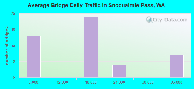
- 639,268Total average daily traffic
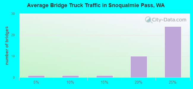
- 126,252Total average daily truck traffic
- National Bridge Inventory (NBI) Registered Bridges for Snoqualmie Pass
- No street view available for this location
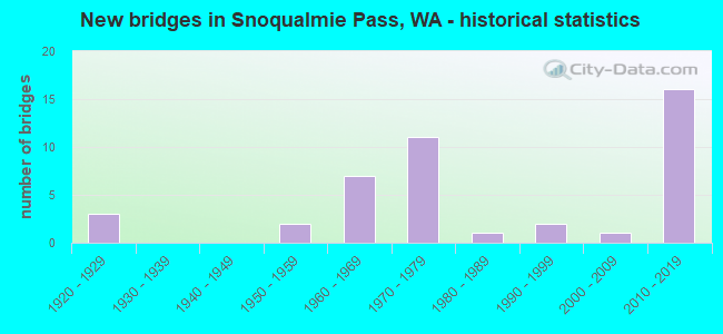
- New bridges - historical statistics
- 31920-1929
- 21950-1959
- 71960-1969
- 111970-1979
- 11980-1989
- 21990-1999
- 12000-2009
- 162010-2019
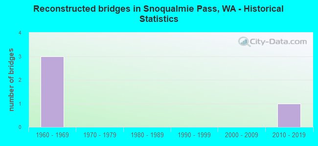
- Reconstructed bridges - Historical Statistics
- 31960-1969
- 01970-1979
- 01980-1989
- 01990-1999
- 02000-2009
- 12010-2019
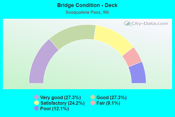
- Bridge Condition - Deck
- 27.3%Very good
- 27.3%Good
- 24.2%Satisfactory
- 9.1%Fair
- 12.1%Poor
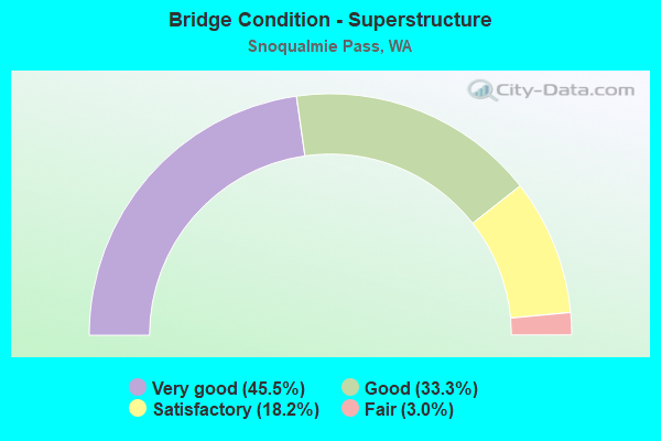
- Bridge Condition - Superstructure
- 45.5%Very good
- 33.3%Good
- 18.2%Satisfactory
- 3.0%Fair
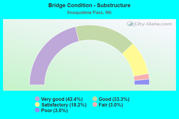
- Bridge Condition - Substructure
- 42.4%Very good
- 33.3%Good
- 18.2%Satisfactory
- 3.0%Fair
- 3.0%Poor
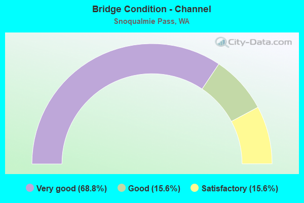
- Bridge Condition - Channel
- 68.8%Very good
- 15.6%Good
- 15.6%Satisfactory
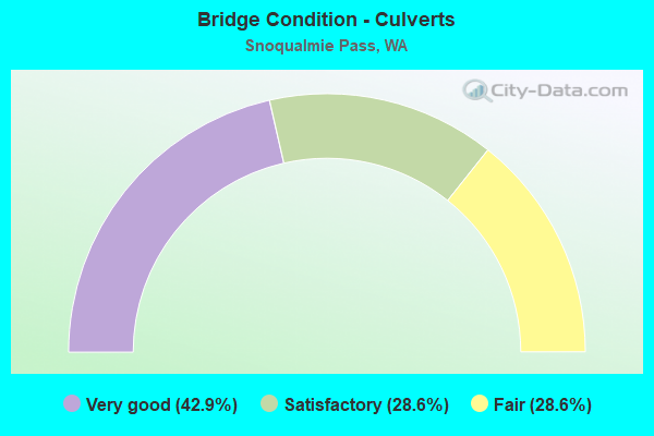
- Bridge Condition - Culverts
- 42.9%Very good
- 28.6%Satisfactory
- 28.6%Fair
Find on map >> Show street view
Structure Number: 61703000016349, Location: NO DATA ENTERED (Lat: 47.372161, Lng: -121.398242), Route carried "on" structure: Federal lands road 90700, Year Built: 2012, Status: Open, Structure Length: 1.85m (6.07ft), Average Daily Traffic: 50 (year 0000), Average Future Daily Traffic: 75 (year 2042), Design Load: HS 25 or greater, Features Intersected: MILL CREEK, Facility Carried by Structure: ROAD
Minimum Vertical Clearance: 30+ m (98+ ft), Kilometerpoint: 3.520, Lanes on structure: 1, Owner: U.S. Forest Service, Approaching Roadway Width: 4.1m (13.5ft), Material/Design: Steel, Design/Construction: Truss - Thru, Number Of Spans In Main Unit: 1, Length of Maximum Span: 18.3m (60.0ft), Curb-To-Curb Width: 4.1m (13.5ft), Out-to-Out Width: 4.2m (13.8ft)
Condition: Deck: Good, Superstructure: Good, Substructure: Good, Channel: Very good, Operating Rating: 52.5 metric tons, Method Used To Determine Operating Rating: Load and Resistance Factor Rating (LRFR) rating reported by rating factor(RF) method using HL-93 loadings, Inventory Rating: 40.8 metric tons, Method Used To Determine Inventory Rating: Load and Resistance Factor Rating (LRFR) rating reported by rating factor(RF) method using HL-93 loadings, Structural Evaluation: Better than present minimum criteria, Deck Geometry: Somewhat better than minimum adequacy, Waterway Adequacy: Superior to present desirable criteria, Approach Roadway Alignment: Equal to present minimum criteria, Designated Inspection Frequency: Every 24 months, Inspection Date: August 2020, Deck Structure Type: Steel plate
Find on map >> Show street view
Structure Number: 86141, Location: 18.2 E JCT SR 202 (Lat: 47.394444, Lng: -121.462417), Route carried "on" structure: Interstate 90, Year Built: 1972, Status: Open, Structure Length: 0.67m (2.20ft), Average Daily Traffic: 18,078 (year 2019), Truck Traffic: 17%, Average Future Daily Traffic: 25,526 (year 2039), Features Intersected: OLALLIE CREEK
Minimum Vertical Clearance: 30+ m (98+ ft), Kilometerpoint: 78.295, Lanes on structure: 4, Base Highway Network: Yes, Owner: State Highway Agency, Approaching Roadway Width: 21.0m (68.9ft), Skew: 1 degrees, Material/Design: Concrete continuous, Design/Construction: Culvert, Number Of Spans In Main Unit: 2, Length of Maximum Span: 3.4m (11.2ft)
Condition: Channel: Satisfactory, Culverts: Satisfactory, Operating Rating: 54.4 metric tons, Method Used To Determine Operating Rating: Field evaluation and documented engineering judgment, Inventory Rating: 32.7 metric tons, Method Used To Determine Inventory Rating: Field evaluation and documented engineering judgment, Structural Evaluation: Equal to present minimum criteria, Waterway Adequacy: Better than present minimum criteria, Approach Roadway Alignment: Equal to present desirable criteria, Length Of Structure Improvement: 0.67m (2.20ft), Designated Inspection Frequency: Every 48 months, Inspection Date: July 2018, Bridge Improvement Cost: $312,000, Roadway Improvement Cost: $62,000, Total Project Cost: $625,000 ( Estimate for 2014)
Find on map >> Show street view
Structure Number: 8447A, Location: JCT I-90 (Lat: 47.427047, Lng: -121.415817), Route carried "under" structure: State highway 906, Year Built: 1969, Structure Length: 0. m, Average Daily Traffic: 1,120 (year 2019), Truck Traffic: 12%, Features Intersected: SR 906 W-W RAMP, Facility Carried by Structure: I-90
Minimum Vertical Clearance: 5.38m (17.65ft), Kilometerpoint: 0.001, Lanes on structure: 8, Lanes under structure: 3, Material/Design: Prestressed concrete continuous, Design/Construction: Stringer/Multi-beam, Length of Maximum Span: 30.5m (100.1ft)
Find on map >> Show street view
Structure Number: 8447C, Location: 2.7 E KING CO (Lat: 47.396694, Lng: -121.397500), Route carried "under" structure: State highway 906, Year Built: 1969, Structure Length: 0. m, Average Daily Traffic: 429 (year 2019), Truck Traffic: 24%, Features Intersected: SR 906, Facility Carried by Structure: I-90
Minimum Vertical Clearance: 5.08m (16.67ft), Kilometerpoint: 4.265, Lanes on structure: 8, Lanes under structure: 2, Material/Design: Prestressed concrete continuous, Design/Construction: Stringer/Multi-beam, Length of Maximum Span: 25.3m (83.0ft)
Find on map >> Show street view
Structure Number: 9092A, Location: 17.1 E JCT SR 202 (Lat: 47.395583, Lng: -121.480500), Route carried "under" structure: Interstate 90, Year Built: 1971, Structure Length: 0. m, Average Daily Traffic: 35,823 (year 2019), Truck Traffic: 17%, Features Intersected: I-90, Facility Carried by Structure: HANSEN CR RD
Minimum Vertical Clearance: 6.15m (20.18ft), Kilometerpoint: 76.782, Lanes on structure: 2, Lanes under structure: 6, Material/Design: Prestressed concrete continuous, Design/Construction: Stringer/Multi-beam, Length of Maximum Span: 41.1m (134.8ft)