Bridge Statistics for Sylvania, Ohio (OH)
Condition, Traffic, Stress, Structural Evaluation, Project Costs
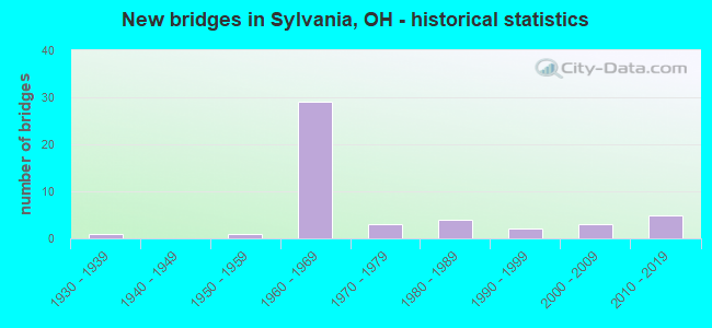
- New bridges - historical statistics
- 11930-1939
- 11950-1959
- 291960-1969
- 31970-1979
- 41980-1989
- 21990-1999
- 32000-2009
- 52010-2019
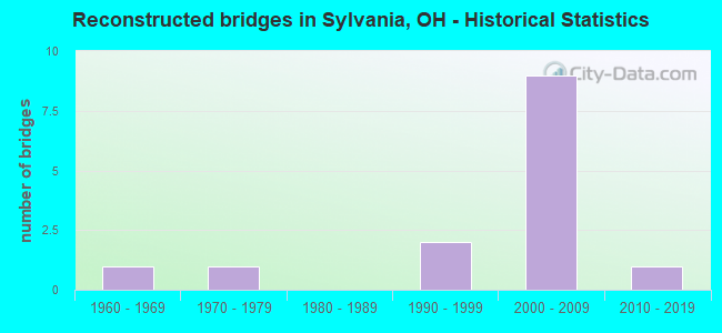
- Reconstructed bridges - Historical Statistics
- 11960-1969
- 11970-1979
- 01980-1989
- 21990-1999
- 92000-2009
- 12010-2019
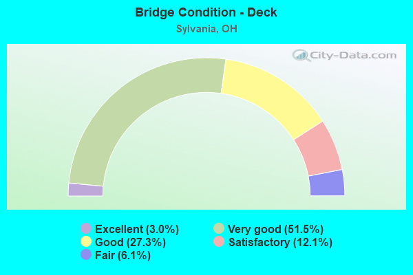
- Bridge Condition - Deck
- 3.0%Excellent
- 51.5%Very good
- 27.3%Good
- 12.1%Satisfactory
- 6.1%Fair
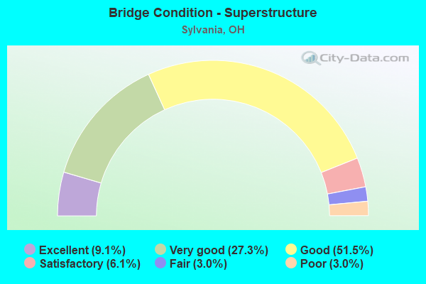
- Bridge Condition - Superstructure
- 9.1%Excellent
- 27.3%Very good
- 51.5%Good
- 6.1%Satisfactory
- 3.0%Fair
- 3.0%Poor
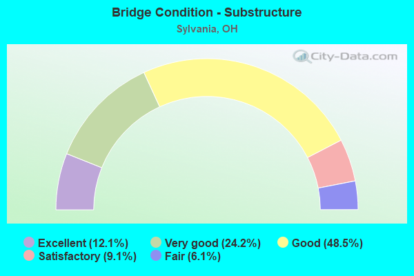
- Bridge Condition - Substructure
- 12.1%Excellent
- 24.2%Very good
- 48.5%Good
- 9.1%Satisfactory
- 6.1%Fair
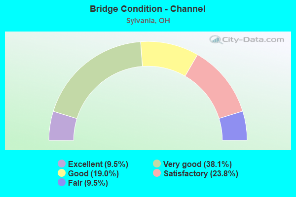
- Bridge Condition - Channel
- 9.5%Excellent
- 38.1%Very good
- 19.0%Good
- 23.8%Satisfactory
- 9.5%Fair
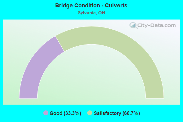
- Bridge Condition - Culverts
- 33.3%Good
- 66.7%Satisfactory
Find on map >> Show street view
Structure Number: 4800559, Location: 0.1 MI WEST MITCHAW RD. (Lat: 41.673519, Lng: -83.763011), Route carried "on" structure: US 20, Year Built: 1989, Status: Open, Structure Length: 2.16m (7.09ft), Average Daily Traffic: 8,299 (year 2019), Truck Traffic: 14%, Average Future Daily Traffic: 12,381 (year 2039), Design Load: HS 20+Mod, Features Intersected: PRAIRIE DITCH
Minimum Vertical Clearance: 30+ m (98+ ft), Kilometerpoint: 9.656, Lanes on structure: 2, Base Highway Network: Yes, Owner: State Highway Agency, Approaching Roadway Width: 9.1m (29.9ft), Skew: 2 degrees, Material/Design: Concrete continuous, Design/Construction: Slab, Number Of Spans In Main Unit: 3, Length of Maximum Span: 7.9m (25.9ft), Curb-To-Curb Width: 13.4m (44.0ft), Out-to-Out Width: 13.4m (44.0ft)
Condition: Deck: Good, Superstructure: Good, Substructure: Good, Channel: Fair, Operating Rating: 42.1 metric tons, Method Used To Determine Operating Rating: Load Factor (LF) rating reported by rating factor (RF) method using MS18 loading, Inventory Rating: 32.4 metric tons, Method Used To Determine Inventory Rating: Load Factor (LF) rating reported by rating factor (RF) method using MS18 loading, Structural Evaluation: Better than present minimum criteria, Deck Geometry: Equal to present minimum criteria, Waterway Adequacy: Equal to present minimum criteria, Approach Roadway Alignment: Equal to present desirable criteria, Designated Inspection Frequency: Every 24 months, Inspection Date: April 2021, Deck Structure Type: Concrete Cast-file-Place, Wearing Surface/Protective System: Wearing Surface: Latex Concrete, Deck Protection: Epoxy Coated Reinforcing
Find on map >> Show street view
Structure Number: 4801016, Location: JCT. U.S. 23 AND BLOSSMAN (Lat: 41.682639, Lng: -83.694789), Route carried "on" structure: US 23, Year Built: 2015, Status: Open, Structure Length: 7.28m (23.88ft), Average Daily Traffic: 17,400 (year 2015), Truck Traffic: 18%, Average Future Daily Traffic: 22,441 (year 2035), Design Load: HL 93, Features Intersected: BLOSSMAN RD. AND BIKE TR
Minimum Vertical Clearance: 30+ m (98+ ft), Kilometerpoint: 15.622, Lanes on structure: 2, Lanes under structure: 2, Base Highway Network: Yes, Owner: State Highway Agency, Approaching Roadway Width: 12.2m (40.0ft), Material/Design: Steel continuous, Design/Construction: Stringer/Multi-beam, Number Of Spans In Main Unit: 4, Length of Maximum Span: 21.3m (69.9ft), Curb-To-Curb Width: 13.4m (44.0ft), Out-to-Out Width: 14.3m (46.9ft)
Condition: Deck: Very good, Superstructure: Very good, Substructure: Excellent, Operating Rating: 61.6 metric tons, Method Used To Determine Operating Rating: Load and Resistance Factor Rating (LRFR) rating reported by rating factor(RF) method using HL-93 loadings, Inventory Rating: 48.6 metric tons, Method Used To Determine Inventory Rating: Load and Resistance Factor Rating (LRFR) rating reported by rating factor(RF) method using HL-93 loadings, Structural Evaluation: Equal to present desirable criteria, Deck Geometry: Superior to present desirable criteria, Underclear: Meets minimum limits, Approach Roadway Alignment: Equal to present desirable criteria, Designated Inspection Frequency: Every 24 months, Inspection Date: March 2021, Deck Structure Type: Concrete Cast-file-Place, Wearing Surface/Protective System: Wearing Surface: Monolithic Concrete, Deck Protection: Epoxy Coated Reinforcing
Find on map >> Show street view
Structure Number: 480104, Location: JCT. USR 23 AND IR 475 (Lat: 41.685200, Lng: -83.695439), Route carried "on" structure: US 23, Year Built: 2015, Status: Open, Structure Length: 8.87m (29.10ft), Average Daily Traffic: 17,400 (year 2015), Truck Traffic: 18%, Average Future Daily Traffic: 24,151 (year 2035), Design Load: HL 93, Features Intersected: IR 475
Minimum Vertical Clearance: 30+ m (98+ ft), Kilometerpoint: 15.643, Lanes on structure: 2, Lanes under structure: 1, Base Highway Network: Yes, Owner: State Highway Agency, Approaching Roadway Width: 12.2m (40.0ft), Skew: 4 degrees, Material/Design: Steel continuous, Design/Construction: Stringer/Multi-beam, Number Of Spans In Main Unit: 3, Length of Maximum Span: 36.6m (120.1ft), Curb-To-Curb Width: 13.4m (44.0ft), Out-to-Out Width: 14.6m (47.9ft)
Condition: Deck: Good, Superstructure: Very good, Substructure: Excellent, Operating Rating: 58.3 metric tons, Method Used To Determine Operating Rating: Load and Resistance Factor Rating (LRFR) rating reported by rating factor(RF) method using HL-93 loadings, Inventory Rating: 45.4 metric tons, Method Used To Determine Inventory Rating: Load and Resistance Factor Rating (LRFR) rating reported by rating factor(RF) method using HL-93 loadings, Structural Evaluation: Equal to present desirable criteria, Deck Geometry: Superior to present desirable criteria, Underclear: Meets minimum limits, Approach Roadway Alignment: Equal to present desirable criteria, Length Of Structure Improvement: 8.87m (29.10ft), Designated Inspection Frequency: Every 24 months, Inspection Date: March 2021, Deck Structure Type: Concrete Cast-file-Place, Wearing Surface/Protective System: Wearing Surface: Monolithic Concrete, Deck Protection: Epoxy Coated Reinforcing
Find on map >> Show street view
Structure Number: 4801059, Location: 0.77 mi. North of USR 20 (Lat: 41.686461, Lng: -83.694800), Route carried "on" structure: US 23, Year Built: 1962, Status: Open, Structure Length: 5.67m (18.60ft), Average Daily Traffic: 23,927 (year 2019), Truck Traffic: 14%, Average Future Daily Traffic: 40,814 (year 2039), Design Load: HS 20+Mod, Features Intersected: 475SB &RAMP 23SB TO 475E
Minimum Vertical Clearance: 4.62m (15.16ft), Kilometerpoint: 15.772, Lanes on structure: 2, Lanes under structure: 2, Base Highway Network: Yes, Owner: State Highway Agency, Approaching Roadway Width: 11.0m (36.1ft), Skew: 4 degrees, Material/Design: Steel continuous, Design/Construction: Stringer/Multi-beam, Number Of Spans In Main Unit: 3, Length of Maximum Span: 23.2m (76.1ft), Curb-To-Curb Width: 12.1m (39.7ft), Out-to-Out Width: 13.5m (44.3ft)
Condition: Deck: Good, Superstructure: Good, Substructure: Good, Operating Rating: 51.8 metric tons, Method Used To Determine Operating Rating: Load and Resistance Factor Rating (LRFR) rating reported by rating factor(RF) method using HL-93 loadings, Inventory Rating: 38.9 metric tons, Method Used To Determine Inventory Rating: Load and Resistance Factor Rating (LRFR) rating reported by rating factor(RF) method using HL-93 loadings, Structural Evaluation: Better than present minimum criteria, Deck Geometry: Meets minimum limits, Underclear: Equal to present minimum criteria, Approach Roadway Alignment: Equal to present desirable criteria, Designated Inspection Frequency: Every 24 months, Inspection Date: March 2021, Deck Structure Type: Concrete Cast-file-Place, Wearing Surface/Protective System: Wearing Surface: Integral Concrete
Find on map >> Show street view
Structure Number: 4801083, Location: 0.25 Mi. N. of IR 475 (Lat: 41.690119, Lng: -83.696469), Route carried "on" structure: US 23, Year Built: 1962, Year Reconstructed: 2006, Status: Open, Structure Length: 5.33m (17.49ft), Average Daily Traffic: 32,342 (year 2019), Truck Traffic: 19%, Average Future Daily Traffic: 40,814 (year 2039), Design Load: HS 20, Features Intersected: CR 5 SYLVANIA AVE
Minimum Vertical Clearance: 30+ m (98+ ft), Kilometerpoint: 16.190, Lanes on structure: 2, Lanes under structure: 2, Base Highway Network: Yes, Owner: State Highway Agency, Approaching Roadway Width: 11.0m (36.1ft), Material/Design: Steel continuous, Design/Construction: Stringer/Multi-beam, Number Of Spans In Main Unit: 3, Length of Maximum Span: 22.3m (73.2ft), Curb-To-Curb Width: 16.2m (53.1ft), Out-to-Out Width: 17.2m (56.4ft)
Condition: Deck: Very good, Superstructure: Good, Substructure: Very good, Operating Rating: 71.3 metric tons, Method Used To Determine Operating Rating: Load and Resistance Factor Rating (LRFR) rating reported by rating factor(RF) method using HL-93 loadings, Inventory Rating: 55.1 metric tons, Method Used To Determine Inventory Rating: Load and Resistance Factor Rating (LRFR) rating reported by rating factor(RF) method using HL-93 loadings, Structural Evaluation: Better than present minimum criteria, Deck Geometry: Superior to present desirable criteria, Underclear: Equal to present minimum criteria, Approach Roadway Alignment: Equal to present desirable criteria, Designated Inspection Frequency: Every 24 months, Inspection Date: March 2021, Deck Structure Type: Concrete Cast-file-Place, Wearing Surface/Protective System: Wearing Surface: Monolithic Concrete, Deck Protection: Epoxy Coated Reinforcing
Find on map >> Show street view
Structure Number: 4801113, Location: 0.25 Mi. N. of IR 475 (Lat: 41.690219, Lng: -83.695100), Route carried "on" structure: US 23, Year Built: 1962, Year Reconstructed: 2006, Status: Open, Structure Length: 5.33m (17.49ft), Average Daily Traffic: 32,342 (year 2019), Truck Traffic: 19%, Average Future Daily Traffic: 38,500 (year 2039), Design Load: HS 20, Features Intersected: CR 5 SYLVANIA AVE
Minimum Vertical Clearance: 30+ m (98+ ft), Kilometerpoint: 16.190, Lanes on structure: 2, Lanes under structure: 2, Base Highway Network: Yes, Owner: State Highway Agency, Approaching Roadway Width: 11.0m (36.1ft), Material/Design: Steel continuous, Design/Construction: Stringer/Multi-beam, Number Of Spans In Main Unit: 3, Length of Maximum Span: 22.3m (73.2ft), Curb-To-Curb Width: 18.9m (62.0ft), Out-to-Out Width: 20.2m (66.3ft)
Condition: Deck: Very good, Superstructure: Good, Substructure: Very good, Operating Rating: 71.3 metric tons, Method Used To Determine Operating Rating: Load and Resistance Factor Rating (LRFR) rating reported by rating factor(RF) method using HL-93 loadings, Inventory Rating: 55.1 metric tons, Method Used To Determine Inventory Rating: Load and Resistance Factor Rating (LRFR) rating reported by rating factor(RF) method using HL-93 loadings, Structural Evaluation: Better than present minimum criteria, Deck Geometry: Superior to present desirable criteria, Underclear: Equal to present minimum criteria, Approach Roadway Alignment: Equal to present desirable criteria, Designated Inspection Frequency: Every 24 months, Inspection Date: March 2021, Deck Structure Type: Concrete Cast-file-Place, Wearing Surface/Protective System: Wearing Surface: Monolithic Concrete, Deck Protection: Epoxy Coated Reinforcing
Find on map >> Show street view
Structure Number: 4801148, Location: 0.92 Mi. N. of IR 475 (Lat: 41.700089, Lng: -83.694781), Route carried "on" structure: US 23, Year Built: 1962, Year Reconstructed: 2006, Status: Open, Structure Length: 5.64m (18.50ft), Average Daily Traffic: 32,342 (year 2019), Truck Traffic: 19%, Average Future Daily Traffic: 40,814 (year 2039), Design Load: HS 20, Features Intersected: NORFOLK SOUTHERN R.R.
Minimum Vertical Clearance: 30+ m (98+ ft), Kilometerpoint: 17.284, Lanes on structure: 2, Base Highway Network: Yes, Owner: State Highway Agency, Approaching Roadway Width: 11.6m (38.1ft), Skew: 3 degrees, Material/Design: Steel continuous, Design/Construction: Stringer/Multi-beam, Number Of Spans In Main Unit: 3, Length of Maximum Span: 21.3m (69.9ft), Curb-To-Curb Width: 12.5m (41.0ft), Out-to-Out Width: 13.5m (44.3ft)
Condition: Deck: Very good, Superstructure: Good, Substructure: Good, Operating Rating: 51.8 metric tons, Method Used To Determine Operating Rating: Load and Resistance Factor Rating (LRFR) rating reported by rating factor(RF) method using HL-93 loadings, Inventory Rating: 42.1 metric tons, Method Used To Determine Inventory Rating: Load and Resistance Factor Rating (LRFR) rating reported by rating factor(RF) method using HL-93 loadings, Structural Evaluation: Better than present minimum criteria, Deck Geometry: Better than present minimum criteria, Underclear: Better than present minimum criteria, Approach Roadway Alignment: Equal to present desirable criteria, Designated Inspection Frequency: Every 24 months, Inspection Date: March 2021, Deck Structure Type: Concrete Cast-file-Place, Wearing Surface/Protective System: Wearing Surface: Monolithic Concrete, Deck Protection: Epoxy Coated Reinforcing
Find on map >> Show street view
Structure Number: 4801172, Location: 0.92 Mi. N. of IR 475 (Lat: 41.699839, Lng: -83.694550), Route carried "on" structure: US 23, Year Built: 1962, Year Reconstructed: 2006, Status: Open, Structure Length: 5.64m (18.50ft), Average Daily Traffic: 32,342 (year 2019), Truck Traffic: 19%, Average Future Daily Traffic: 40,814 (year 2039), Design Load: HS 20, Features Intersected: NORFOLK SOUTHERN R.R.
Minimum Vertical Clearance: 30+ m (98+ ft), Kilometerpoint: 17.284, Lanes on structure: 2, Base Highway Network: Yes, Owner: State Highway Agency, Approaching Roadway Width: 11.6m (38.1ft), Skew: 3 degrees, Material/Design: Steel continuous, Design/Construction: Stringer/Multi-beam, Number Of Spans In Main Unit: 3, Length of Maximum Span: 21.3m (69.9ft), Curb-To-Curb Width: 12.5m (41.0ft), Out-to-Out Width: 13.5m (44.3ft)
Condition: Deck: Very good, Superstructure: Good, Substructure: Good, Operating Rating: 51.8 metric tons, Method Used To Determine Operating Rating: Load and Resistance Factor Rating (LRFR) rating reported by rating factor(RF) method using HL-93 loadings, Inventory Rating: 38.9 metric tons, Method Used To Determine Inventory Rating: Load and Resistance Factor Rating (LRFR) rating reported by rating factor(RF) method using HL-93 loadings, Structural Evaluation: Better than present minimum criteria, Deck Geometry: Better than present minimum criteria, Underclear: Better than present minimum criteria, Approach Roadway Alignment: Equal to present desirable criteria, Designated Inspection Frequency: Every 24 months, Inspection Date: March 2021, Deck Structure Type: Concrete Cast-file-Place, Wearing Surface/Protective System: Wearing Surface: Monolithic Concrete, Deck Protection: Epoxy Coated Reinforcing
Find on map >> Show street view
Structure Number: 4801202, Location: 1.0 Mi. N. of IR 475 (Lat: 41.701269, Lng: -83.693981), Route carried "on" structure: US 23, Year Built: 1962, Year Reconstructed: 2006, Status: Open, Structure Length: 5.24m (17.19ft), Average Daily Traffic: 32,342 (year 2019), Truck Traffic: 19%, Average Future Daily Traffic: 40,814 (year 2039), Design Load: HS 20, Features Intersected: HOLLAND SYLVANIA ROAD
Minimum Vertical Clearance: 30+ m (98+ ft), Kilometerpoint: 17.429, Lanes on structure: 2, Lanes under structure: 2, Base Highway Network: Yes, Owner: State Highway Agency, Approaching Roadway Width: 11.6m (38.1ft), Skew: 3 degrees, Material/Design: Steel continuous, Design/Construction: Stringer/Multi-beam, Number Of Spans In Main Unit: 3, Length of Maximum Span: 19.8m (65.0ft), Curb-To-Curb Width: 12.5m (41.0ft), Out-to-Out Width: 13.5m (44.3ft)
Condition: Deck: Very good, Superstructure: Good, Substructure: Good, Operating Rating: 51.8 metric tons, Method Used To Determine Operating Rating: Load and Resistance Factor Rating (LRFR) rating reported by rating factor(RF) method using HL-93 loadings, Inventory Rating: 42.1 metric tons, Method Used To Determine Inventory Rating: Load and Resistance Factor Rating (LRFR) rating reported by rating factor(RF) method using HL-93 loadings, Structural Evaluation: Better than present minimum criteria, Deck Geometry: Better than present minimum criteria, Underclear: Equal to present minimum criteria, Approach Roadway Alignment: Equal to present desirable criteria, Designated Inspection Frequency: Every 24 months, Inspection Date: March 2021, Deck Structure Type: Concrete Cast-file-Place, Wearing Surface/Protective System: Wearing Surface: Monolithic Concrete, Deck Protection: Epoxy Coated Reinforcing
Find on map >> Show street view
Structure Number: 4801237, Location: 1.0 Mi. N. of IR 475 (Lat: 41.701069, Lng: -83.693750), Route carried "on" structure: US 23, Year Built: 1962, Year Reconstructed: 2006, Status: Open, Structure Length: 5.24m (17.19ft), Average Daily Traffic: 32,342 (year 2019), Truck Traffic: 19%, Average Future Daily Traffic: 40,814 (year 2039), Design Load: HS 20, Features Intersected: HOLLAND SYLVANIA ROAD
Minimum Vertical Clearance: 30+ m (98+ ft), Kilometerpoint: 17.429, Lanes on structure: 2, Lanes under structure: 2, Base Highway Network: Yes, Owner: State Highway Agency, Approaching Roadway Width: 11.6m (38.1ft), Skew: 3 degrees, Material/Design: Steel continuous, Design/Construction: Stringer/Multi-beam, Number Of Spans In Main Unit: 3, Length of Maximum Span: 19.8m (65.0ft), Curb-To-Curb Width: 12.5m (41.0ft), Out-to-Out Width: 13.5m (44.3ft)
Condition: Deck: Very good, Superstructure: Good, Substructure: Good, Operating Rating: 42.1 metric tons, Method Used To Determine Operating Rating: Load Factor (LF) rating reported by rating factor (RF) method using MS18 loading, Inventory Rating: 32.4 metric tons, Method Used To Determine Inventory Rating: Load Factor (LF) rating reported by rating factor (RF) method using MS18 loading, Structural Evaluation: Better than present minimum criteria, Deck Geometry: Better than present minimum criteria, Underclear: Equal to present minimum criteria, Approach Roadway Alignment: Equal to present desirable criteria, Designated Inspection Frequency: Every 24 months, Inspection Date: March 2021, Deck Structure Type: Concrete Cast-file-Place, Wearing Surface/Protective System: Wearing Surface: Monolithic Concrete, Deck Protection: Epoxy Coated Reinforcing
Find on map >> Show street view
Structure Number: 4801261, Location: 0.22 Mi. S. of SR 51 (Lat: 41.711850, Lng: -83.688450), Route carried "on" structure: US 23, Year Built: 1962, Status: Open, Structure Length: 3.23m (10.60ft), Average Daily Traffic: 23,989 (year 2019), Truck Traffic: 19%, Average Future Daily Traffic: 26,500 (year 2039), Design Load: HS 20, Features Intersected: OTTAWA RIVER
Minimum Vertical Clearance: 30+ m (98+ ft), Kilometerpoint: 18.749, Lanes on structure: 2, Base Highway Network: Yes, Owner: State Highway Agency, Approaching Roadway Width: 11.6m (38.1ft), Material/Design: Concrete continuous, Design/Construction: Slab, Number Of Spans In Main Unit: 3, Length of Maximum Span: 12.2m (40.0ft), Curb-To-Curb Width: 12.1m (39.7ft), Out-to-Out Width: 22.1m (72.5ft)
Condition: Deck: Good, Superstructure: Good, Substructure: Good, Channel: Good, Operating Rating: 38.9 metric tons, Method Used To Determine Operating Rating: Load Factor (LF) rating reported by rating factor (RF) method using MS18 loading, Inventory Rating: 22.7 metric tons, Method Used To Determine Inventory Rating: Load Factor (LF) rating reported by rating factor (RF) method using MS18 loading, Structural Evaluation: Somewhat better than minimum adequacy, Deck Geometry: Equal to present minimum criteria, Waterway Adequacy: Equal to present minimum criteria, Approach Roadway Alignment: Equal to present desirable criteria, Designated Inspection Frequency: Every 24 months, Inspection Date: March 2021, Deck Structure Type: Concrete Cast-file-Place, Wearing Surface/Protective System: Wearing Surface: Integral Concrete
Find on map >> Show street view
Structure Number: 4801296, Location: 0.22 Mi. S. of SR 51 (Lat: 41.711861, Lng: -83.688031), Route carried "on" structure: US 23, Year Built: 1962, Status: Open, Structure Length: 3.23m (10.60ft), Average Daily Traffic: 23,989 (year 2019), Truck Traffic: 19%, Average Future Daily Traffic: 26,500 (year 2039), Design Load: HS 20, Features Intersected: OTTAWA RIVER
Minimum Vertical Clearance: 30+ m (98+ ft), Kilometerpoint: 18.749, Lanes on structure: 2, Base Highway Network: Yes, Owner: State Highway Agency, Approaching Roadway Width: 11.6m (38.1ft), Material/Design: Concrete continuous, Design/Construction: Slab, Number Of Spans In Main Unit: 3, Length of Maximum Span: 12.2m (40.0ft), Curb-To-Curb Width: 12.1m (39.7ft), Out-to-Out Width: 13.5m (44.3ft)
Condition: Deck: Good, Superstructure: Good, Substructure: Good, Channel: Good, Operating Rating: 58.3 metric tons, Method Used To Determine Operating Rating: Load Factor (LF) rating reported by rating factor (RF) method using MS18 loading, Inventory Rating: 35.6 metric tons, Method Used To Determine Inventory Rating: Load Factor (LF) rating reported by rating factor (RF) method using MS18 loading, Structural Evaluation: Better than present minimum criteria, Deck Geometry: Equal to present minimum criteria, Waterway Adequacy: Equal to present desirable criteria, Approach Roadway Alignment: Equal to present desirable criteria, Designated Inspection Frequency: Every 24 months, Inspection Date: March 2021, Deck Structure Type: Concrete Cast-file-Place, Wearing Surface/Protective System: Wearing Surface: Integral Concrete
Find on map >> Show street view
Structure Number: 4805135, Location: 0.03 Mile East of USR 23 (Lat: 41.711669, Lng: -83.687450), Route carried "on" structure: Ramp State highway 184, Year Built: 1962, Status: Open, Structure Length: 3.23m (10.60ft), Average Daily Traffic: 11,087 (year 2018), Truck Traffic: 4%, Average Future Daily Traffic: 13,500 (year 2038), Design Load: HS 20, Features Intersected: OTTAWA RIVER
Minimum Vertical Clearance: 30+ m (98+ ft), Kilometerpoint: 0.048, Lanes on structure: 1, Base Highway Network: Yes, Owner: State Highway Agency, Approaching Roadway Width: 8.5m (27.9ft), Material/Design: Concrete continuous, Design/Construction: Slab, Number Of Spans In Main Unit: 3, Length of Maximum Span: 12.2m (40.0ft), Curb or Sidewalk Widths: Left: 0.0m, Right: 0.3m (1.0ft), Curb-To-Curb Width: 9.0m (29.5ft), Out-to-Out Width: 10.5m (34.4ft)
Condition: Deck: Fair, Superstructure: Fair, Substructure: Satisfactory, Channel: Satisfactory, Operating Rating: 32.4 metric tons, Method Used To Determine Operating Rating: Allowable Stress (AS) rating reported by rating factor (RF) method using MS18 loading, Inventory Rating: 22.7 metric tons, Method Used To Determine Inventory Rating: Allowable Stress (AS) rating reported by rating factor (RF) method using MS18 loading, Structural Evaluation: Somewhat better than minimum adequacy, Deck Geometry: Superior to present desirable criteria, Waterway Adequacy: Equal to present minimum criteria, Approach Roadway Alignment: Equal to present minimum criteria, Designated Inspection Frequency: Every 12 months, Inspection Date: January 2022, Deck Structure Type: Concrete Cast-file-Place, Wearing Surface/Protective System: Wearing Surface: Latex Concrete
Find on map >> Show street view
Structure Number: 4805224, Location: Monroe SR 51 over USR 23 (Lat: 41.715531, Lng: -83.687811), Route carried "on" structure: State highway 51, Year Built: 1960, Status: Open, Structure Length: 8.53m (27.99ft), Average Daily Traffic: 37,274 (year 2019), Truck Traffic: 2%, Average Future Daily Traffic: 44,500 (year 2039), Design Load: HS 20, Features Intersected: USR 23, Facility Carried by Structure: Monroe Street
Minimum Vertical Clearance: 30+ m (98+ ft), Kilometerpoint: 20.680, Lanes on structure: 4, Lanes under structure: 4, Base Highway Network: Yes, Owner: State Highway Agency, Approaching Roadway Width: 16.5m (54.1ft), Material/Design: Steel continuous, Design/Construction: Stringer/Multi-beam, Number Of Spans In Main Unit: 4, Length of Maximum Span: 26.5m (86.9ft), Curb or Sidewalk Widths: Left: 1.5m (4.9ft), Right: 1.5m (4.9ft), Curb-To-Curb Width: 16.5m (54.1ft), Out-to-Out Width: 20.3m (66.6ft)
Condition: Deck: Satisfactory, Superstructure: Good, Substructure: Good, Operating Rating: 55.1 metric tons, Method Used To Determine Operating Rating: Load and Resistance Factor Rating (LRFR) rating reported by rating factor(RF) method using HL-93 loadings, Inventory Rating: 42.1 metric tons, Method Used To Determine Inventory Rating: Load and Resistance Factor Rating (LRFR) rating reported by rating factor(RF) method using HL-93 loadings, Structural Evaluation: Better than present minimum criteria, Deck Geometry: Meets minimum limits, Underclear: High priority of corrective action, Approach Roadway Alignment: Equal to present desirable criteria, Designated Inspection Frequency: Every 12 months, Inspection Date: January 2022, Deck Structure Type: Concrete Cast-file-Place, Wearing Surface/Protective System: Wearing Surface: Integral Concrete
Find on map >> Show street view
Structure Number: 4807863, Location: 0.5 MI. N. OF USR 20 (Lat: 41.682669, Lng: -83.695350), Route carried "on" structure: Interstate 475, Year Built: 1962, Year Reconstructed: 2015, Status: Open, Structure Length: 5.85m (19.19ft), Average Daily Traffic: 40,285 (year 2010), Truck Traffic: 13%, Average Future Daily Traffic: 55,916 (year 2030), Design Load: HS 20, Features Intersected: BLOSSMAN RD. & BIKE TRAI
Minimum Vertical Clearance: 30+ m (98+ ft), Kilometerpoint: 15.353, Lanes on structure: 3, Lanes under structure: 2, Base Highway Network: Yes, Owner: State Highway Agency, Approaching Roadway Width: 9.1m (29.9ft), Skew: 31 degrees, Material/Design: Steel continuous, Design/Construction: Stringer/Multi-beam, Number Of Spans In Main Unit: 4, Length of Maximum Span: 16.8m (55.1ft), Curb-To-Curb Width: 15.7m (51.5ft), Out-to-Out Width: 31.7m (104.0ft)
Condition: Deck: Very good, Superstructure: Very good, Substructure: Very good, Operating Rating: 97.2 metric tons, Method Used To Determine Operating Rating: Load and Resistance Factor Rating (LRFR) rating reported by rating factor(RF) method using HL-93 loadings, Inventory Rating: 87.5 metric tons, Method Used To Determine Inventory Rating: Load and Resistance Factor Rating (LRFR) rating reported by rating factor(RF) method using HL-93 loadings, Structural Evaluation: Equal to present desirable criteria, Deck Geometry: Somewhat better than minimum adequacy, Underclear: Somewhat better than minimum adequacy, Approach Roadway Alignment: Equal to present desirable criteria, Designated Inspection Frequency: Every 24 months, Inspection Date: January 2021, Deck Structure Type: Concrete Cast-file-Place, Wearing Surface/Protective System: Wearing Surface: Monolithic Concrete
Find on map >> Show street view
Structure Number: 4807898, Location: 0.5 MI. N. OF USR 20 (Lat: 41.682700, Lng: -83.694461), Route carried "on" structure: Interstate 475, Year Built: 1962, Year Reconstructed: 1983, Status: Open, Structure Length: 5.85m (19.19ft), Average Daily Traffic: 40,285 (year 2010), Truck Traffic: 13%, Average Future Daily Traffic: 55,916 (year 2030), Design Load: HS 20, Features Intersected: BLOSSMAN RD. & BIKE TRAI
Minimum Vertical Clearance: 30+ m (98+ ft), Kilometerpoint: 15.353, Lanes on structure: 2, Lanes under structure: 3, Base Highway Network: Yes, Owner: State Highway Agency, Approaching Roadway Width: 15.2m (49.9ft), Material/Design: Steel continuous, Design/Construction: Stringer/Multi-beam, Number Of Spans In Main Unit: 4, Length of Maximum Span: 16.8m (55.1ft), Curb-To-Curb Width: 17.6m (57.7ft), Out-to-Out Width: 19.1m (62.7ft)
Condition: Deck: Good, Superstructure: Good, Substructure: Good, Operating Rating: 42.1 metric tons, Method Used To Determine Operating Rating: Allowable Stress (AS) rating reported by rating factor (RF) method using MS18 loading, Inventory Rating: 32.4 metric tons, Method Used To Determine Inventory Rating: Allowable Stress (AS) rating reported by rating factor (RF) method using MS18 loading, Structural Evaluation: Better than present minimum criteria, Deck Geometry: Superior to present desirable criteria, Underclear: Somewhat better than minimum adequacy, Approach Roadway Alignment: Equal to present desirable criteria, Designated Inspection Frequency: Every 24 months, Inspection Date: January 2021, Deck Structure Type: Concrete Cast-file-Place, Wearing Surface/Protective System: Wearing Surface: Integral Concrete
Find on map >> Show street view
Structure Number: 4807987, Location: Jct. IR 475 & Holland Syl (Lat: 41.689231, Lng: -83.683569), Route carried "on" structure: County highway C1572, Year Built: 1969, Year Reconstructed: 2004, Status: Open, Structure Length: 5.36m (17.59ft), Average Daily Traffic: 19,088 (year 2018), Truck Traffic: 3%, Average Future Daily Traffic: 22,500 (year 2038), Design Load: HS 20+Mod, Features Intersected: IR 475, Facility Carried by Structure: HOLLAND SYLVANIA
Minimum Vertical Clearance: 30+ m (98+ ft), Kilometerpoint: 10.697, Lanes on structure: 4, Lanes under structure: 4, Owner: State Highway Agency, Approaching Roadway Width: 16.5m (54.1ft), Material/Design: Steel continuous, Design/Construction: Stringer/Multi-beam, Number Of Spans In Main Unit: 4, Length of Maximum Span: 14.6m (47.9ft), Curb or Sidewalk Widths: Left: 0.0m, Right: 1.8m (5.9ft), Curb-To-Curb Width: 16.9m (55.4ft), Out-to-Out Width: 19.6m (64.3ft)
Condition: Deck: Good, Superstructure: Good, Substructure: Satisfactory, Operating Rating: 55.1 metric tons, Method Used To Determine Operating Rating: Load and Resistance Factor Rating (LRFR) rating reported by rating factor(RF) method using HL-93 loadings, Inventory Rating: 42.1 metric tons, Method Used To Determine Inventory Rating: Load and Resistance Factor Rating (LRFR) rating reported by rating factor(RF) method using HL-93 loadings, Structural Evaluation: Equal to present minimum criteria, Deck Geometry: Somewhat better than minimum adequacy, Underclear: Meets minimum limits, Approach Roadway Alignment: Equal to present desirable criteria, Designated Inspection Frequency: Every 12 months, Inspection Date: January 2022, Deck Structure Type: Concrete Cast-file-Place, Wearing Surface/Protective System: Wearing Surface: Monolithic Concrete, Deck Protection: Epoxy Coated Reinforcing
Find on map >> Show street view
Structure Number: 4808703, Location: USR 23 & IR 475 Interchan (Lat: 41.686600, Lng: -83.694419), Route carried "on" structure: Ramp Interstate 475, Year Built: 1969, Year Reconstructed: 2006, Status: Open, Structure Length: 6.80m (22.31ft), Average Daily Traffic: 9,837 (year 2019), Truck Traffic: 14%, Average Future Daily Traffic: 11,500 (year 2039), Design Load: HS 20, Features Intersected: 23NB & 475SB, Facility Carried by Structure: USR 23 RAMP
Minimum Vertical Clearance: 30+ m (98+ ft), Kilometerpoint: 15.788, Lanes on structure: 1, Lanes under structure: 4, Owner: State Highway Agency, Approaching Roadway Width: 7.3m (24.0ft), Material/Design: Steel continuous, Design/Construction: Stringer/Multi-beam, Number Of Spans In Main Unit: 3, Length of Maximum Span: 26.8m (87.9ft), Curb-To-Curb Width: 8.2m (26.9ft), Out-to-Out Width: 9.2m (30.2ft)
Condition: Deck: Very good, Superstructure: Good, Substructure: Good, Operating Rating: 42.1 metric tons, Method Used To Determine Operating Rating: Allowable Stress (AS) rating reported by rating factor (RF) method using MS18 loading, Inventory Rating: 32.4 metric tons, Method Used To Determine Inventory Rating: Allowable Stress (AS) rating reported by rating factor (RF) method using MS18 loading, Structural Evaluation: Better than present minimum criteria, Deck Geometry: Superior to present desirable criteria, Underclear: High priority of corrective action, Approach Roadway Alignment: Equal to present desirable criteria, Designated Inspection Frequency: Every 24 months, Inspection Date: March 2021, Deck Structure Type: Concrete Cast-file-Place, Wearing Surface/Protective System: Wearing Surface: Monolithic Concrete, Deck Protection: Epoxy Coated Reinforcing
Find on map >> Show street view
Structure Number: 4830024, Location: 0.3 MI. W. OF HERR ROAD (Lat: 41.687661, Lng: -83.762911), Route carried "on" structure: County highway C0005, Year Built: 1973, Status: Open, Structure Length: 2.83m (9.28ft), Average Daily Traffic: 1,970 (year 2015), Truck Traffic: 8%, Average Future Daily Traffic: 2,734 (year 2035), Design Load: HS 20+Mod, Features Intersected: TENMILE CREEK 0101, Facility Carried by Structure: SYLVANIA AVENUE
Minimum Vertical Clearance: 4.62m (15.16ft), Kilometerpoint: 9.656, Lanes on structure: 2, Owner: County Highway Agency, Approaching Roadway Width: 16.5m (54.1ft), Material/Design: Concrete continuous, Design/Construction: Slab, Number Of Spans In Main Unit: 3, Length of Maximum Span: 10.7m (35.1ft), Curb-To-Curb Width: 16.5m (54.1ft), Out-to-Out Width: 17.7m (58.1ft)
Condition: Deck: Satisfactory, Superstructure: Satisfactory, Substructure: Good, Channel: Very good, Operating Rating: 42.1 metric tons, Method Used To Determine Operating Rating: Load Factor (LF) rating reported by rating factor (RF) method using MS18 loading, Inventory Rating: 32.4 metric tons, Method Used To Determine Inventory Rating: Load Factor (LF) rating reported by rating factor (RF) method using MS18 loading, Structural Evaluation: Equal to present minimum criteria, Deck Geometry: Equal to present minimum criteria, Waterway Adequacy: Equal to present desirable criteria, Approach Roadway Alignment: Equal to present desirable criteria, Designated Inspection Frequency: Every 12 months, Inspection Date: November 2021, Deck Structure Type: Concrete Cast-file-Place, Wearing Surface/Protective System: Wearing Surface: Integral Concrete
Find on map >> Show street view
Structure Number: 4830997, Location: 0.23 MI. N OF CENTRAL AVE (Lat: 41.676950, Lng: -83.756431), Route carried "on" structure: County highway C0041, Year Built: 2006, Status: Open, Structure Length: 2.71m (8.89ft), Average Daily Traffic: 1,290 (year 2015), Truck Traffic: 5%, Average Future Daily Traffic: 1,791 (year 2035), Design Load: HS 20+Mod, Features Intersected: TEN MILE CREEK 0102, Facility Carried by Structure: HERR ROAD
Minimum Vertical Clearance: 30+ m (98+ ft), Kilometerpoint: 0.386, Lanes on structure: 2, Owner: County Highway Agency, Approaching Roadway Width: 9.1m (29.9ft), Material/Design: Prestressed concrete, Design/Construction: Box Beam or Girders - Multiple, Number Of Spans In Main Unit: 3, Length of Maximum Span: 10.7m (35.1ft), Curb-To-Curb Width: 9.1m (29.9ft), Out-to-Out Width: 9.1m (29.9ft)
Condition: Deck: Excellent, Superstructure: Excellent, Substructure: Excellent, Channel: Excellent, Operating Rating: 42.1 metric tons, Method Used To Determine Operating Rating: Load Factor (LF) rating reported by rating factor (RF) method using MS18 loading, Inventory Rating: 32.4 metric tons, Method Used To Determine Inventory Rating: Load Factor (LF) rating reported by rating factor (RF) method using MS18 loading, Structural Evaluation: Equal to present desirable criteria, Deck Geometry: Somewhat better than minimum adequacy, Waterway Adequacy: Superior to present desirable criteria, Approach Roadway Alignment: Superior to present desirable criteria, Designated Inspection Frequency: Every 24 months, Inspection Date: November 2021, Deck Structure Type: Concrete Cast-file-Place, Wearing Surface/Protective System: Wearing Surface: Bituminous, Membrane: Built-up
Find on map >> Show street view
Structure Number: 4831594, Location: 0.02 MI S OF SYLVANIA AVE (Lat: 41.690350, Lng: -83.689939), Route carried "on" structure: County highway T2117, Year Built: 1957, Year Reconstructed: 1990, Status: Open, Structure Length: 1.13m (3.71ft), Average Daily Traffic: 1,949 (year 2015), Truck Traffic: 5%, Average Future Daily Traffic: 2,705 (year 2035), Design Load: H 15, Features Intersected: SHADOW LAKE DITCH 3102, Facility Carried by Structure: OAK PARK RD.
Minimum Vertical Clearance: 30+ m (98+ ft), Kilometerpoint: 49.922, Lanes on structure: 2, Owner: County Highway Agency, Approaching Roadway Width: 8.2m (26.9ft), Material/Design: Steel, Design/Construction: Stringer/Multi-beam, Number Of Spans In Main Unit: 1, Length of Maximum Span: 9.8m (32.2ft), Curb-To-Curb Width: 7.9m (25.9ft), Out-to-Out Width: 8.8m (28.9ft)
Condition: Deck: Very good, Superstructure: Good, Substructure: Satisfactory, Channel: Very good, Operating Rating: 42.1 metric tons, Method Used To Determine Operating Rating: Load Factor (LF) rating reported by rating factor (RF) method using MS18 loading, Inventory Rating: 32.4 metric tons, Method Used To Determine Inventory Rating: Load Factor (LF) rating reported by rating factor (RF) method using MS18 loading, Structural Evaluation: Equal to present minimum criteria, Deck Geometry: Meets minimum limits, Waterway Adequacy: Superior to present desirable criteria, Approach Roadway Alignment: Superior to present desirable criteria, Designated Inspection Frequency: Every 12 months, Inspection Date: November 2021, Deck Structure Type: Concrete Cast-file-Place, Wearing Surface/Protective System: Wearing Surface: Monolithic Concrete
Find on map >> Show street view
Structure Number: 4831616, Location: .5 MI E. OF CENTENNIAL (Lat: 41.702681, Lng: -83.733369), Route carried "on" structure: County highway C0008, Year Built: 1975, Status: Open, Structure Length: 3.29m (10.79ft), Average Daily Traffic: 4,306 (year 2015), Truck Traffic: 9%, Average Future Daily Traffic: 5,977 (year 2035), Design Load: H 20, Features Intersected: TENMILE CREEK 0105, Facility Carried by Structure: BRINT ROAD
Minimum Vertical Clearance: 30+ m (98+ ft), Kilometerpoint: 12.086, Lanes on structure: 2, Owner: County Highway Agency, Approaching Roadway Width: 12.2m (40.0ft), Skew: 1 degrees, Material/Design: Steel continuous, Design/Construction: Stringer/Multi-beam, Number Of Spans In Main Unit: 2, Length of Maximum Span: 31.4m (103.0ft), Curb-To-Curb Width: 12.2m (40.0ft), Out-to-Out Width: 12.2m (40.0ft)
Condition: Deck: Very good, Superstructure: Very good, Substructure: Good, Channel: Good, Operating Rating: 42.1 metric tons, Method Used To Determine Operating Rating: Load Factor (LF) rating reported by rating factor (RF) method using MS18 loading, Inventory Rating: 32.4 metric tons, Method Used To Determine Inventory Rating: Load Factor (LF) rating reported by rating factor (RF) method using MS18 loading, Structural Evaluation: Better than present minimum criteria, Deck Geometry: Equal to present minimum criteria, Waterway Adequacy: Equal to present desirable criteria, Approach Roadway Alignment: Equal to present desirable criteria, Designated Inspection Frequency: Every 24 months, Inspection Date: November 2021, Deck Structure Type: Concrete Cast-file-Place, Wearing Surface/Protective System: Wearing Surface: Bituminous
Find on map >> Show street view
Structure Number: 4831683, Location: 0.08 MI. W. OF FARMINGTON (Lat: 41.698911, Lng: -83.674000), Route carried "on" structure: County highway T2051, Year Built: 1966, Status: Open, Structure Length: 4.05m (13.29ft), Average Daily Traffic: 1,949 (year 2015), Truck Traffic: 5%, Average Future Daily Traffic: 2,705 (year 2035), Design Load: HL 93, Features Intersected: OTTAWA RIVER 3086, Facility Carried by Structure: STURBRIDGE
Minimum Vertical Clearance: 30+ m (98+ ft), Kilometerpoint: 0.097, Lanes on structure: 2, Owner: County Highway Agency, Approaching Roadway Width: 7.3m (24.0ft), Material/Design: Concrete continuous, Design/Construction: Slab, Number Of Spans In Main Unit: 3, Length of Maximum Span: 15.2m (49.9ft), Curb or Sidewalk Widths: Left: 0.9m (3.0ft), Right: 0.9m (3.0ft), Curb-To-Curb Width: 7.3m (24.0ft), Out-to-Out Width: 9.1m (29.9ft)
Condition: Deck: Good, Superstructure: Good, Substructure: Good, Channel: Very good, Operating Rating: 48.6 metric tons, Method Used To Determine Operating Rating: Load Factor (LF) rating reported by rating factor (RF) method using MS18 loading, Inventory Rating: 38.9 metric tons, Method Used To Determine Inventory Rating: Load Factor (LF) rating reported by rating factor (RF) method using MS18 loading, Structural Evaluation: Better than present minimum criteria, Deck Geometry: Meets minimum limits, Waterway Adequacy: Equal to present desirable criteria, Approach Roadway Alignment: Equal to present desirable criteria, Designated Inspection Frequency: Every 24 months, Inspection Date: November 2021, Deck Structure Type: Concrete Cast-file-Place, Wearing Surface/Protective System: Wearing Surface: Low Slump Concrete
Find on map >> Show street view
Structure Number: 4832086, Location: 0.4 MI E. OF CENTENNIAL (Lat: 41.688381, Lng: -83.734650), Route carried "on" structure: County highway C0005, Year Built: 1982, Status: Open, Structure Length: 3.02m (9.91ft), Average Daily Traffic: 7,711 (year 2015), Truck Traffic: 7%, Average Future Daily Traffic: 10,703 (year 2035), Design Load: HS 20+Mod, Features Intersected: TENMILE CREEK 0104, Facility Carried by Structure: SYLVANIA AVE
Minimum Vertical Clearance: 30+ m (98+ ft), Kilometerpoint: 1.674, Lanes on structure: 2, Owner: County Highway Agency, Approaching Roadway Width: 12.2m (40.0ft), Skew: 1 degrees, Material/Design: Prestressed concrete, Design/Construction: Box Beam or Girders - Multiple, Number Of Spans In Main Unit: 2, Length of Maximum Span: 14.3m (46.9ft), Curb-To-Curb Width: 12.2m (40.0ft), Out-to-Out Width: 12.2m (40.0ft)
Condition: Deck: Very good, Superstructure: Very good, Substructure: Very good, Channel: Satisfactory, Operating Rating: 42.1 metric tons, Method Used To Determine Operating Rating: Load Factor (LF) rating reported by rating factor (RF) method using MS18 loading, Inventory Rating: 32.4 metric tons, Method Used To Determine Inventory Rating: Load Factor (LF) rating reported by rating factor (RF) method using MS18 loading, Structural Evaluation: Equal to present desirable criteria, Deck Geometry: Somewhat better than minimum adequacy, Waterway Adequacy: Equal to present desirable criteria, Approach Roadway Alignment: Superior to present desirable criteria, Designated Inspection Frequency: Every 24 months, Inspection Date: November 2021, Deck Structure Type: Concrete Cast-file-Place, Wearing Surface/Protective System: Wearing Surface: Monolithic Concrete, Deck Protection: Epoxy Coated Reinforcing
Find on map >> Show street view
Structure Number: 4832515, Location: 0.23 M. N. OF SYLVANIA AV (Lat: 41.691531, Lng: -83.742800), Route carried "on" structure: County highway C0069, Year Built: 1992, Status: Open, Structure Length: 2.71m (8.89ft), Average Daily Traffic: 6,941 (year 2015), Truck Traffic: 5%, Average Future Daily Traffic: 9,634 (year 2035), Design Load: HS 25 or greater, Features Intersected: FRANCE STONE QUARRY 3085, Facility Carried by Structure: CENTENNIAL ROAD
Minimum Vertical Clearance: 30+ m (98+ ft), Kilometerpoint: 49.648, Lanes on structure: 2, Owner: County Highway Agency, Approaching Roadway Width: 12.2m (40.0ft), Material/Design: Steel, Design/Construction: Stringer/Multi-beam, Number Of Spans In Main Unit: 1, Length of Maximum Span: 25.9m (85.0ft), Curb-To-Curb Width: 12.2m (40.0ft), Out-to-Out Width: 13.1m (43.0ft)
Condition: Deck: Very good, Superstructure: Very good, Substructure: Very good, Operating Rating: 42.1 metric tons, Method Used To Determine Operating Rating: Allowable Stress (AS) rating reported by rating factor (RF) method using MS18 loading, Inventory Rating: 32.4 metric tons, Method Used To Determine Inventory Rating: Allowable Stress (AS) rating reported by rating factor (RF) method using MS18 loading, Structural Evaluation: Equal to present desirable criteria, Deck Geometry: Somewhat better than minimum adequacy, Approach Roadway Alignment: Superior to present desirable criteria, Designated Inspection Frequency: Every 24 months, Inspection Date: November 2021, Deck Structure Type: Concrete Cast-file-Place, Wearing Surface/Protective System: Wearing Surface: Monolithic Concrete, Deck Protection: Epoxy Coated Reinforcing
Find on map >> Show street view
Structure Number: 4832639, Location: 0.1 MI. N. OF SILICA RD. (Lat: 41.678011, Lng: -83.742169), Route carried "on" structure: County highway C0069, Year Built: 2001, Status: Open, Structure Length: 3.96m (12.99ft), Average Daily Traffic: 6,941 (year 2015), Truck Traffic: 5%, Average Future Daily Traffic: 9,634 (year 2035), Design Load: HS 25 or greater, Features Intersected: TEN MILE CREEK 0103, Facility Carried by Structure: CENTENIAL ROAD
Minimum Vertical Clearance: 30+ m (98+ ft), Kilometerpoint: 6.373, Lanes on structure: 2, Owner: County Highway Agency, Approaching Roadway Width: 13.4m (44.0ft), Skew: 3 degrees, Material/Design: Prestressed concrete continuous, Design/Construction: Box Beam or Girders - Multiple, Number Of Spans In Main Unit: 3, Length of Maximum Span: 13.7m (44.9ft), Curb-To-Curb Width: 13.6m (44.6ft), Out-to-Out Width: 14.6m (47.9ft)
Condition: Deck: Very good, Superstructure: Excellent, Substructure: Excellent, Channel: Excellent, Operating Rating: 42.1 metric tons, Method Used To Determine Operating Rating: Load Factor (LF) rating reported by rating factor (RF) method using MS18 loading, Inventory Rating: 32.4 metric tons, Method Used To Determine Inventory Rating: Load Factor (LF) rating reported by rating factor (RF) method using MS18 loading, Structural Evaluation: Equal to present desirable criteria, Deck Geometry: Superior to present desirable criteria, Waterway Adequacy: Superior to present desirable criteria, Approach Roadway Alignment: Equal to present desirable criteria, Designated Inspection Frequency: Every 24 months, Inspection Date: November 2021, Deck Structure Type: Concrete Cast-file-Place, Wearing Surface/Protective System: Wearing Surface: Monolithic Concrete, Deck Protection: Epoxy Coated Reinforcing
Find on map >> Show street view
Structure Number: 4862473, Location: 0.09 M. S. OF MONROE ST. (Lat: 41.714161, Lng: -83.707989), Route carried "on" structure: City street MILIC, Year Built: 1938, Year Reconstructed: 1968, Status: Posted for load, Structure Length: 2.35m (7.71ft), Average Daily Traffic: 2,959 (year 2019), Truck Traffic: 4%, Average Future Daily Traffic: 4,107 (year 2039), Design Load: HS 20+Mod, Features Intersected: TENMILE CREEK 0106, Facility Carried by Structure: SILICA DRIVE
Minimum Vertical Clearance: 30+ m (98+ ft), Kilometerpoint: 1.706, Lanes on structure: 2, Owner: City or Municipal Highway Agency, Approaching Roadway Width: 9.1m (29.9ft), Material/Design: Concrete, Design/Construction: Arch - Deck, Number Of Spans In Main Unit: 1, Length of Maximum Span: 22.3m (73.2ft), Curb or Sidewalk Widths: Left: 1.8m (5.9ft), Right: 1.8m (5.9ft), Curb-To-Curb Width: 9.0m (29.5ft), Out-to-Out Width: 10.2m (33.5ft)
Condition: Deck: Fair, Superstructure: Poor, Substructure: Fair, Channel: Very good, Operating Rating: 32.4 metric tons, Method Used To Determine Operating Rating: Load Factor (LF) rating reported by rating factor (RF) method using MS18 loading, Inventory Rating: 19.4 metric tons, Method Used To Determine Inventory Rating: Load Factor (LF) rating reported by rating factor (RF) method using MS18 loading, Structural Evaluation: Meets minimum limits, Deck Geometry: Meets minimum limits, Waterway Adequacy: Superior to present desirable criteria, Approach Roadway Alignment: Better than present minimum criteria, Bridge Posting: Required (Relationship of Operating Rating to Maximum Legal Load: 20.0 - 29.9% below), Designated Inspection Frequency: Every 12 months, Inspection Date: August 2021
Find on map >> Show street view
Structure Number: 4862481, Location: 0.09 M. S. OF MONROE ST. (Lat: 41.714300, Lng: -83.703050), Route carried "on" structure: City street MMAIN, Year Built: 1969, Year Reconstructed: 2008, Status: Open, Structure Length: 1.95m (6.40ft), Average Daily Traffic: 15,824 (year 2019), Truck Traffic: 3%, Average Future Daily Traffic: 21,964 (year 2039), Design Load: HS 25 or greater, Features Intersected: TENMILE CREEK 0107, Facility Carried by Structure: SOUTH MAIN STREET
Minimum Vertical Clearance: 30+ m (98+ ft), Kilometerpoint: 1.722, Lanes on structure: 3, Owner: City or Municipal Highway Agency, Approaching Roadway Width: 11.0m (36.1ft), Material/Design: Prestressed concrete, Design/Construction: Stringer/Multi-beam, Number Of Spans In Main Unit: 1, Length of Maximum Span: 18.0m (59.1ft), Curb or Sidewalk Widths: Left: 1.4m (4.6ft), Right: 1.4m (4.6ft), Curb-To-Curb Width: 14.7m (48.2ft), Out-to-Out Width: 18.0m (59.1ft)
Condition: Deck: Very good, Superstructure: Excellent, Substructure: Very good, Channel: Very good, Operating Rating: 90.7 metric tons, Method Used To Determine Operating Rating: Load Factor (LF) rating reported by rating factor (RF) method using MS18 loading, Inventory Rating: 55.1 metric tons, Method Used To Determine Inventory Rating: Load Factor (LF) rating reported by rating factor (RF) method using MS18 loading, Structural Evaluation: Equal to present desirable criteria, Deck Geometry: Somewhat better than minimum adequacy, Waterway Adequacy: Superior to present desirable criteria, Approach Roadway Alignment: Superior to present desirable criteria, Designated Inspection Frequency: Every 24 months, Inspection Date: August 2021, Deck Structure Type: Concrete Cast-file-Place, Wearing Surface/Protective System: Wearing Surface: Monolithic Concrete
Find on map >> Show street view
Structure Number: 4862503, Location: 0.06 M. N. OF ERIE STREET (Lat: 41.718450, Lng: -83.734831), Route carried "on" structure: City street MFARM, Year Built: 1979, Status: Open, Structure Length: 0.79m (2.59ft), Average Daily Traffic: 118 (year 1993), Truck Traffic: 5%, Average Future Daily Traffic: 164 (year 2013), Features Intersected: SCHREIBER DITCH 2402, Facility Carried by Structure: OLD FARM LANE
Minimum Vertical Clearance: 30+ m (98+ ft), Kilometerpoint: 38.656, Lanes on structure: 2, Owner: City or Municipal Highway Agency, Approaching Roadway Width: 8.2m (26.9ft), Skew: 1 degrees, Material/Design: Steel, Design/Construction: Culvert, Number Of Spans In Main Unit: 2, Length of Maximum Span: 3.4m (11.2ft)
Condition: Channel: Satisfactory, Culverts: Satisfactory, Operating Rating: 51.8 metric tons, Method Used To Determine Operating Rating: Load and Resistance Factor Rating (LRFR) rating reported by rating factor(RF) method using HL-93 loadings, Inventory Rating: 42.1 metric tons, Method Used To Determine Inventory Rating: Load and Resistance Factor Rating (LRFR) rating reported by rating factor(RF) method using HL-93 loadings, Structural Evaluation: Equal to present minimum criteria, Waterway Adequacy: Better than present minimum criteria, Approach Roadway Alignment: Equal to present desirable criteria, Designated Inspection Frequency: Every 12 months, Inspection Date: August 2021
Find on map >> Show street view
Structure Number: 4862538, Location: 0.16 M. E. OF S. MAIN ST. (Lat: 41.715500, Lng: -83.700050), Route carried "on" structure: City street MONRO, Year Built: 1961, Status: Open, Structure Length: 1.22m (4.00ft), Average Daily Traffic: 22,112 (year 2019), Truck Traffic: 2%, Average Future Daily Traffic: 30,691 (year 2039), Design Load: HS 15, Features Intersected: NORTH TENMILE CREEK 0127
Minimum Vertical Clearance: 30+ m (98+ ft), Kilometerpoint: 2.044, Lanes on structure: 4, Owner: City or Municipal Highway Agency, Approaching Roadway Width: 16.5m (54.1ft), Skew: 2 degrees, Material/Design: Concrete, Design/Construction: Slab, Number Of Spans In Main Unit: 1, Length of Maximum Span: 11.6m (38.1ft), Curb or Sidewalk Widths: Left: 1.8m (5.9ft), Right: 1.8m (5.9ft), Curb-To-Curb Width: 16.5m (54.1ft), Out-to-Out Width: 20.7m (67.9ft)
Condition: Deck: Satisfactory, Superstructure: Satisfactory, Substructure: Fair, Channel: Good, Operating Rating: 48.6 metric tons, Method Used To Determine Operating Rating: Load Factor (LF) rating reported by rating factor (RF) method using MS18 loading, Inventory Rating: 29.2 metric tons, Method Used To Determine Inventory Rating: Load Factor (LF) rating reported by rating factor (RF) method using MS18 loading, Structural Evaluation: Somewhat better than minimum adequacy, Deck Geometry: Meets minimum limits, Waterway Adequacy: Superior to present desirable criteria, Approach Roadway Alignment: Superior to present desirable criteria, Designated Inspection Frequency: Every 12 months, Inspection Date: August 2021, Deck Structure Type: Concrete Cast-file-Place, Wearing Surface/Protective System: Wearing Surface: Monolithic Concrete
Find on map >> Show street view
Structure Number: 4862562, Location: 0.07 M. S. OF MONROE ST. (Lat: 41.717200, Lng: -83.715531), Route carried "on" structure: City street MPOST, Year Built: 1961, Year Reconstructed: 2009, Status: Open, Structure Length: 2.62m (8.60ft), Average Daily Traffic: 350 (year 2020), Truck Traffic: 2%, Average Future Daily Traffic: 500 (year 2040), Design Load: HS 20+Mod, Features Intersected: TENMILE CREEK 3093, Facility Carried by Structure: OLD POST ROAD
Minimum Vertical Clearance: 3.89m (12.76ft), Kilometerpoint: 0.225, Lanes on structure: 2, Owner: City or Municipal Highway Agency, Approaching Roadway Width: 7.6m (24.9ft), Material/Design: Prestressed concrete, Design/Construction: Box Beam or Girders - Multiple, Number Of Spans In Main Unit: 1, Length of Maximum Span: 25.6m (84.0ft), Curb or Sidewalk Widths: Left: 1.2m (3.9ft), Right: 1.2m (3.9ft), Curb-To-Curb Width: 7.6m (24.9ft), Out-to-Out Width: 10.7m (35.1ft)
Condition: Deck: Good, Superstructure: Very good, Substructure: Good, Channel: Fair, Operating Rating: 81.0 metric tons, Method Used To Determine Operating Rating: Load Factor (LF) rating reported by rating factor (RF) method using MS18 loading, Inventory Rating: 32.4 metric tons, Method Used To Determine Inventory Rating: Load Factor (LF) rating reported by rating factor (RF) method using MS18 loading, Structural Evaluation: Better than present minimum criteria, Deck Geometry: High priority of corrective action, Waterway Adequacy: Better than present minimum criteria, Approach Roadway Alignment: Equal to present minimum criteria, Designated Inspection Frequency: Every 24 months, Inspection Date: August 2021, Deck Structure Type: Concrete Cast-file-Place, Wearing Surface/Protective System: Wearing Surface: Monolithic Concrete
Find on map >> Show street view
Structure Number: 4862589, Location: 0.06 M. S. OF SUNVALLEY (Lat: 41.715269, Lng: -83.726131), Route carried "on" structure: City street MONBK, Year Built: 2006, Status: Open, Structure Length: 3.11m (10.20ft), Average Daily Traffic: 1,745 (year 2006), Truck Traffic: 5%, Average Future Daily Traffic: 2,422 (year 2026), Design Load: HS 25 or greater, Features Intersected: TENMILE CREEK 2403, Facility Carried by Structure: BONNIEBROOK ST
Minimum Vertical Clearance: 30+ m (98+ ft), Kilometerpoint: 38.673, Lanes on structure: 2, Owner: City or Municipal Highway Agency, Approaching Roadway Width: 7.9m (25.9ft), Material/Design: Prestressed concrete continuous, Design/Construction: Box Beam or Girders - Multiple, Number Of Spans In Main Unit: 3, Length of Maximum Span: 10.7m (35.1ft), Curb or Sidewalk Widths: Left: 1.2m (3.9ft), Right: 1.2m (3.9ft), Curb-To-Curb Width: 7.9m (25.9ft), Out-to-Out Width: 11.0m (36.1ft)
Condition: Deck: Very good, Superstructure: Very good, Substructure: Very good, Channel: Very good, Operating Rating: 68.0 metric tons, Method Used To Determine Operating Rating: Load Factor (LF) rating reported by rating factor (RF) method using MS18 loading, Inventory Rating: 38.9 metric tons, Method Used To Determine Inventory Rating: Load Factor (LF) rating reported by rating factor (RF) method using MS18 loading, Structural Evaluation: Equal to present desirable criteria, Deck Geometry: Meets minimum limits, Waterway Adequacy: Superior to present desirable criteria, Approach Roadway Alignment: Equal to present desirable criteria, Designated Inspection Frequency: Every 24 months, Inspection Date: August 2021, Deck Structure Type: Concrete Cast-file-Place, Wearing Surface/Protective System: Wearing Surface: Monolithic Concrete, Deck Protection: Epoxy Coated Reinforcing
Find on map >> Show street view
Structure Number: 4862597, Location: 0.04 M. N. OF ERIE STREET (Lat: 41.717919, Lng: -83.738239), Route carried "on" structure: City street MPPLE, Year Built: 1989, Status: Open, Structure Length: 0.85m (2.79ft), Average Daily Traffic: 8,398 (year 2015), Truck Traffic: 7%, Average Future Daily Traffic: 11,656 (year 2035), Features Intersected: SCHREIBER DITCH 2446, Facility Carried by Structure: APPLE MEADOW DRIVE
Minimum Vertical Clearance: 30+ m (98+ ft), Kilometerpoint: 39.365, Lanes on structure: 2, Owner: City or Municipal Highway Agency, Approaching Roadway Width: 7.9m (25.9ft), Skew: 2 degrees, Material/Design: Steel, Design/Construction: Culvert, Number Of Spans In Main Unit: 2, Length of Maximum Span: 4.0m (13.1ft), Curb or Sidewalk Widths: Left: 1.2m (3.9ft), Right: 1.2m (3.9ft)
Condition: Channel: Satisfactory, Culverts: Satisfactory, Operating Rating: 81.0 metric tons, Method Used To Determine Operating Rating: Load and Resistance Factor Rating (LRFR) rating reported by rating factor(RF) method using HL-93 loadings, Inventory Rating: 64.8 metric tons, Method Used To Determine Inventory Rating: Load and Resistance Factor Rating (LRFR) rating reported by rating factor(RF) method using HL-93 loadings, Structural Evaluation: Equal to present minimum criteria, Waterway Adequacy: Better than present minimum criteria, Approach Roadway Alignment: Superior to present desirable criteria, Designated Inspection Frequency: Every 12 months, Inspection Date: August 2021
Find on map >> Show street view
Structure Number: 48626, Location: 0.04 M. W. OF APPLE MEAD. (Lat: 41.718850, Lng: -83.739611), Route carried "on" structure: City street MEVIN, Year Built: 1989, Status: Open, Structure Length: 0.67m (2.20ft), Average Daily Traffic: 678 (year 1993), Truck Traffic: 5%, Average Future Daily Traffic: 941 (year 2013), Features Intersected: SCHREIBER DITCH 2447, Facility Carried by Structure: KEVIN LANE
Minimum Vertical Clearance: 30+ m (98+ ft), Kilometerpoint: 39.381, Lanes on structure: 2, Owner: City or Municipal Highway Agency, Approaching Roadway Width: 8.2m (26.9ft), Skew: 2 degrees, Material/Design: Steel, Design/Construction: Culvert, Number Of Spans In Main Unit: 2, Length of Maximum Span: 3.0m (9.8ft), Curb or Sidewalk Widths: Left: 1.2m (3.9ft), Right: 1.2m (3.9ft)
Condition: Channel: Satisfactory, Culverts: Good, Operating Rating: 94.0 metric tons, Method Used To Determine Operating Rating: Load and Resistance Factor Rating (LRFR) rating reported by rating factor(RF) method using HL-93 loadings, Inventory Rating: 74.5 metric tons, Method Used To Determine Inventory Rating: Load and Resistance Factor Rating (LRFR) rating reported by rating factor(RF) method using HL-93 loadings, Structural Evaluation: Better than present minimum criteria, Waterway Adequacy: Better than present minimum criteria, Approach Roadway Alignment: Superior to present desirable criteria, Designated Inspection Frequency: Every 24 months, Inspection Date: August 2021
Find on map >> Show street view
Structure Number: 4862619, Location: 0.2 MI. S. OF MONROE ST. (Lat: 41.714139, Lng: -83.694789), Route carried "on" structure: City street MARRN, Year Built: 1990, Status: Posted for load, Structure Length: 3.14m (10.30ft), Average Daily Traffic: 14,418 (year 2019), Truck Traffic: 2%, Average Future Daily Traffic: 20,012 (year 2039), Design Load: HS 20+Mod, Features Intersected: OTTAWA RIVER 0108, Facility Carried by Structure: HARROUN ROAD
Minimum Vertical Clearance: 30+ m (98+ ft), Kilometerpoint: 1.738, Lanes on structure: 4, Owner: City or Municipal Highway Agency, Approaching Roadway Width: 15.9m (52.2ft), Material/Design: Steel, Design/Construction: Stringer/Multi-beam, Number Of Spans In Main Unit: 1, Length of Maximum Span: 29.9m (98.1ft), Curb or Sidewalk Widths: Left: 1.8m (5.9ft), Right: 1.8m (5.9ft), Curb-To-Curb Width: 15.9m (52.2ft), Out-to-Out Width: 20.1m (65.9ft)
Condition: Deck: Satisfactory, Superstructure: Good, Substructure: Good, Channel: Very good, Operating Rating: 38.9 metric tons, Method Used To Determine Operating Rating: Load Factor (LF) rating reported by rating factor (RF) method using MS18 loading, Inventory Rating: 22.7 metric tons, Method Used To Determine Inventory Rating: Load Factor (LF) rating reported by rating factor (RF) method using MS18 loading, Structural Evaluation: Somewhat better than minimum adequacy, Deck Geometry: Meets minimum limits, Waterway Adequacy: Superior to present desirable criteria, Approach Roadway Alignment: Superior to present desirable criteria, Bridge Posting: Required (Relationship of Operating Rating to Maximum Legal Load: 10.0 - 19.9% below), Designated Inspection Frequency: Every 12 months, Inspection Date: August 2021, Deck Structure Type: Concrete Cast-file-Place, Wearing Surface/Protective System: Wearing Surface: Monolithic Concrete, Deck Protection: Epoxy Coated Reinforcing
Find on map >> Show street view
Structure Number: 4862627, Location: 0.05 M. E. OF LITTLE ROAD (Lat: 41.717631, Lng: -83.733019), Route carried "on" structure: City street MERIE, Year Built: 2013, Status: Open, Structure Length: 0.91m (2.99ft), Average Daily Traffic: 12,181 (year 2019), Truck Traffic: 2%, Average Future Daily Traffic: 16,907 (year 2039), Design Load: HL 93, Features Intersected: SCHREIBER DITCH 0122, Facility Carried by Structure: ERIE STREET
Minimum Vertical Clearance: 30+ m (98+ ft), Kilometerpoint: 1.320, Lanes on structure: 2, Owner: City or Municipal Highway Agency, Approaching Roadway Width: 13.7m (44.9ft), Skew: 2 degrees, Material/Design: Concrete, Design/Construction: Frame, Number Of Spans In Main Unit: 1, Length of Maximum Span: 8.5m (27.9ft), Curb or Sidewalk Widths: Left: 1.8m (5.9ft), Right: 1.8m (5.9ft), Curb-To-Curb Width: 13.7m (44.9ft), Out-to-Out Width: 21.0m (68.9ft)
Condition: Deck: Very good, Superstructure: Very good, Substructure: Very good, Channel: Very good, Operating Rating: 64.8 metric tons, Method Used To Determine Operating Rating: Load and Resistance Factor Rating (LRFR) rating reported by rating factor(RF) method using HL-93 loadings, Inventory Rating: 48.6 metric tons, Method Used To Determine Inventory Rating: Load and Resistance Factor Rating (LRFR) rating reported by rating factor(RF) method using HL-93 loadings, Structural Evaluation: Equal to present desirable criteria, Deck Geometry: Superior to present desirable criteria, Waterway Adequacy: Equal to present desirable criteria, Approach Roadway Alignment: Superior to present desirable criteria, Designated Inspection Frequency: Every 24 months, Inspection Date: August 2021, Deck Structure Type: Concrete Cast-file-Place, Wearing Surface/Protective System: Wearing Surface: Bituminous, Membrane: Preformed Fabric
Find on map >> Show street view
Structure Number: 4801016, Location: JCT. U.S. 23 AND BLOSSMAN (Lat: 41.682639, Lng: -83.694789), Route carried "under" structure: City street T1163, Year Built: 2015, Structure Length: 0. m, Average Daily Traffic: 2,100 (year 2017), Truck Traffic: 8%, Features Intersected: USR 23, Facility Carried by Structure: BLOSSMAN RD
Minimum Vertical Clearance: 10.21m (33.50ft), Kilometerpoint: 1.094, Lanes on structure: 2, Lanes under structure: 2, Material/Design: Steel continuous, Design/Construction: Stringer/Multi-beam, Length of Maximum Span: 21.3m (69.9ft)
Find on map >> Show street view
Structure Number: 480104, Location: JCT. USR 23 AND IR 475 (Lat: 41.685200, Lng: -83.695439), Route carried "under" structure: Interstate 475, Year Built: 2015, Structure Length: 0. m, Average Daily Traffic: 29,993 (year 2019), Truck Traffic: 5%, Features Intersected: USR 23
Minimum Vertical Clearance: 5.03m (16.50ft), Kilometerpoint: 15.643, Lanes on structure: 2, Lanes under structure: 1, Material/Design: Steel continuous, Design/Construction: Stringer/Multi-beam, Length of Maximum Span: 36.6m (120.1ft)
Find on map >> Show street view
Structure Number: 4801059, Location: 0.77 mi. North of USR 20 (Lat: 41.686461, Lng: -83.694800), Route carried "under" structure: Interstate 475, Year Built: 1962, Structure Length: 0. m, Average Daily Traffic: 29,993 (year 2019), Truck Traffic: 5%, Features Intersected: USR 23
Minimum Vertical Clearance: 5.05m (16.57ft), Kilometerpoint: 15.772, Lanes on structure: 2, Lanes under structure: 2, Material/Design: Steel continuous, Design/Construction: Stringer/Multi-beam, Length of Maximum Span: 23.2m (76.1ft)
Find on map >> Show street view
Structure Number: 4801083, Location: 0.25 Mi. N. of IR 475 (Lat: 41.690119, Lng: -83.696469), Route carried "under" structure: County highway 5, Year Built: 1962, Structure Length: 0. m, Average Daily Traffic: 16,051 (year 2019), Truck Traffic: 7%, Features Intersected: USR 23
Minimum Vertical Clearance: 4.55m (14.93ft), Kilometerpoint: 15.289, Lanes on structure: 2, Lanes under structure: 2, Material/Design: Steel continuous, Design/Construction: Stringer/Multi-beam, Length of Maximum Span: 22.3m (73.2ft)
Find on map >> Show street view
Structure Number: 4801113, Location: 0.25 Mi. N. of IR 475 (Lat: 41.690219, Lng: -83.695100), Route carried "under" structure: County highway 5, Year Built: 1962, Structure Length: 0. m, Average Daily Traffic: 16,051 (year 2019), Truck Traffic: 7%, Features Intersected: USR 23
Minimum Vertical Clearance: 4.42m (14.50ft), Kilometerpoint: 15.418, Lanes on structure: 2, Lanes under structure: 2, Material/Design: Steel continuous, Design/Construction: Stringer/Multi-beam, Length of Maximum Span: 22.3m (73.2ft)