Bridge Statistics for Tupelo, Mississippi (MS)
Condition, Traffic, Stress, Structural Evaluation, Project Costs
- National Bridge Inventory (NBI) Statistics
- 226Number of bridges
- 3,376ft / 1,029mTotal length
- $6,585,513,000Total costs
- 1,934,391Total average daily traffic
- 230,671Total average daily truck traffic
- National Bridge Inventory (NBI) Registered Bridges for Tupelo
- No street view available for this location
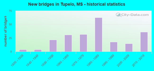
- New bridges - historical statistics
- 41930-1939
- 41940-1949
- 221950-1959
- 311960-1969
- 321970-1979
- 631980-1989
- 181990-1999
- 152000-2009
- 362010-2019
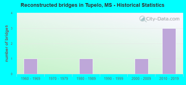
- Reconstructed bridges - Historical Statistics
- 11960-1969
- 01970-1979
- 11980-1989
- 01990-1999
- 12000-2009
- 32010-2019
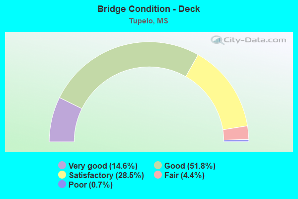
- Bridge Condition - Deck
- 14.6%Very good
- 51.8%Good
- 28.5%Satisfactory
- 4.4%Fair
- 0.7%Poor
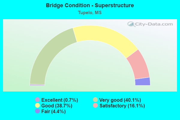
- Bridge Condition - Superstructure
- 0.7%Excellent
- 40.1%Very good
- 38.7%Good
- 16.1%Satisfactory
- 4.4%Fair
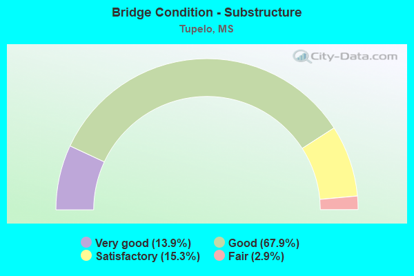
- Bridge Condition - Substructure
- 13.9%Very good
- 67.9%Good
- 15.3%Satisfactory
- 2.9%Fair
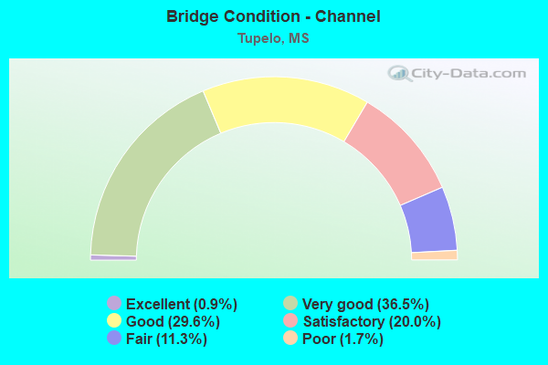
- Bridge Condition - Channel
- 0.9%Excellent
- 36.5%Very good
- 29.6%Good
- 20.0%Satisfactory
- 11.3%Fair
- 1.7%Poor
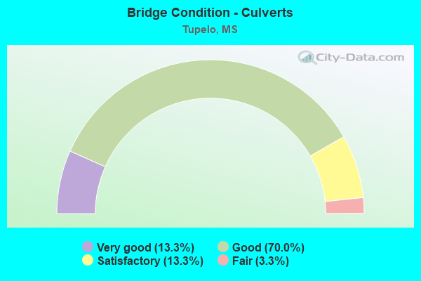
- Bridge Condition - Culverts
- 13.3%Very good
- 70.0%Good
- 13.3%Satisfactory
- 3.3%Fair
Find on map >> Show street view
Structure Number: SA5800000000037, Location: SEC 12 T 9S R 4E B (Lat: 34.308167, Lng: -88.836194), Route carried "on" structure: County highway 1866, Year Built: 1959, Status: Open, Structure Length: 0.67m (2.20ft), Average Daily Traffic: 2,600 (year 2013), Truck Traffic: 8%, Average Future Daily Traffic: 4,000 (year 2035), Design Load: HS 15, Features Intersected: EADS CREEK, Facility Carried by Structure: ENDVILLE ROAD
Minimum Vertical Clearance: 30+ m (98+ ft), Kilometerpoint: 5.310, Lanes on structure: 2, Owner: County Highway Agency, Approaching Roadway Width: 8.5m (27.9ft), Skew: 3 degrees, Material/Design: Concrete, Design/Construction: Culvert, Number Of Spans In Main Unit: 2, Length of Maximum Span: 2.4m (7.9ft)
Condition: Channel: Good, Culverts: Good, Operating Rating: 32.4 metric tons, Method Used To Determine Operating Rating: Allowable Stress (AS), Inventory Rating: 24.3 metric tons, Method Used To Determine Inventory Rating: Allowable Stress (AS), Structural Evaluation: Equal to present minimum criteria, Waterway Adequacy: Equal to present minimum criteria, Approach Roadway Alignment: Equal to present desirable criteria, Length Of Structure Improvement: 1.74m (5.71ft), Designated Inspection Frequency: Every 24 months, Inspection Date: Febuary 2021, Bridge Improvement Cost: $250,000, Roadway Improvement Cost: $25,000, Total Project Cost: $275,000 ( Estimate for 2021)
Find on map >> Show street view
Structure Number: SA5800000000041, Location: SEC 25 T 9S R 4E (Lat: 34.271778, Lng: -88.827056), Route carried "on" structure: County highway 43, Year Built: 2000, Status: Open, Structure Length: 5.49m (18.01ft), Average Daily Traffic: 240 (year 2014), Truck Traffic: 8%, Average Future Daily Traffic: 360 (year 2034), Design Load: HS 20, Features Intersected: COONEWAH CREEK, Facility Carried by Structure: SIMS GIN RD
Minimum Vertical Clearance: 30+ m (98+ ft), Kilometerpoint: 1.770, Lanes on structure: 2, Owner: County Highway Agency, Approaching Roadway Width: 7.3m (24.0ft), Material/Design: Prestressed concrete, Design/Construction: Stringer/Multi-beam, Number Of Spans In Main Unit: 3, Length of Maximum Span: 30.5m (100.1ft), Curb or Sidewalk Widths: Left: 0.5m (1.6ft), Right: 0.5m (1.6ft), Curb-To-Curb Width: 8.5m (27.9ft), Out-to-Out Width: 9.5m (31.2ft)
Condition: Deck: Good, Superstructure: Very good, Substructure: Very good, Channel: Very good, Operating Rating: 75.5 metric tons, Method Used To Determine Operating Rating: Load Factor (LF) rating reported by rating factor (RF) method using MS18 loading, Inventory Rating: 39.2 metric tons, Method Used To Determine Inventory Rating: Load Factor (LF) rating reported by rating factor (RF) method using MS18 loading, Structural Evaluation: Equal to present desirable criteria, Deck Geometry: Equal to present minimum criteria, Waterway Adequacy: Equal to present desirable criteria, Approach Roadway Alignment: Equal to present desirable criteria, Length Of Structure Improvement: 6.11m (20.05ft), Designated Inspection Frequency: Every 24 months, Inspection Date: January 2021, Bridge Improvement Cost: $364,000, Roadway Improvement Cost: $36,000, Total Project Cost: $448,000 ( Estimate for 2015), Deck Structure Type: Concrete Cast-file-Place, Wearing Surface/Protective System: Wearing Surface: Monolithic Concrete
Find on map >> Show street view
Structure Number: SA5800000000065, Location: SEC 13 T10S R 4E B (Lat: 34.206167, Lng: -88.828528), Route carried "on" structure: County highway 853, Year Built: 1972, Status: Open, Structure Length: 3.66m (12.01ft), Average Daily Traffic: 1,900 (year 2014), Truck Traffic: 10%, Average Future Daily Traffic: 2,850 (year 2034), Design Load: HS 15, Features Intersected: DRY CREEK, Facility Carried by Structure: VALLEY ROAD
Minimum Vertical Clearance: 30+ m (98+ ft), Kilometerpoint: 5.632, Lanes on structure: 2, Owner: County Highway Agency, Approaching Roadway Width: 6.7m (22.0ft), Material/Design: Prestressed concrete, Design/Construction: Stringer/Multi-beam, Number Of Spans In Main Unit: 3, Length of Maximum Span: 12.2m (40.0ft), Curb or Sidewalk Widths: Left: 0.4m (1.3ft), Right: 0.4m (1.3ft), Curb-To-Curb Width: 7.9m (25.9ft), Out-to-Out Width: 8.8m (28.9ft)
Condition: Deck: Satisfactory, Superstructure: Very good, Substructure: Good, Channel: Satisfactory, Operating Rating: 60.3 metric tons, Method Used To Determine Operating Rating: Load Factor (LF) rating reported by rating factor (RF) method using MS18 loading, Inventory Rating: 27.2 metric tons, Method Used To Determine Inventory Rating: Load Factor (LF) rating reported by rating factor (RF) method using MS18 loading, Structural Evaluation: Equal to present minimum criteria, Deck Geometry: Meets minimum limits, Waterway Adequacy: Equal to present desirable criteria, Approach Roadway Alignment: Better than present minimum criteria, Length Of Structure Improvement: 4.27m (14.01ft), Designated Inspection Frequency: Every 24 months, Inspection Date: January 2022, Bridge Improvement Cost: $255,000, Roadway Improvement Cost: $25,000, Total Project Cost: $314,000 ( Estimate for 2015), Deck Structure Type: Concrete Cast-file-Place, Wearing Surface/Protective System: Wearing Surface: Monolithic Concrete
Find on map >> Show street view
Structure Number: SA5800000000097, Location: SEC 11 T10S R 4E B (Lat: 34.235136, Lng: -88.844403), Route carried "on" structure: County highway 70, Year Built: 1953, Status: Open, Structure Length: 0.78m (2.56ft), Average Daily Traffic: 3,500 (year 2017), Truck Traffic: 20%, Average Future Daily Traffic: 2,500 (year 2030), Design Load: H 15, Features Intersected: TRIB TO DRY CREEK, Facility Carried by Structure: WEST MAIN STREET
Minimum Vertical Clearance: 30+ m (98+ ft), Kilometerpoint: 4.640, Lanes on structure: 2, Owner: County Highway Agency, Approaching Roadway Width: 7.3m (24.0ft), Skew: 4 degrees, Material/Design: Concrete, Design/Construction: Culvert, Number Of Spans In Main Unit: 1, Length of Maximum Span: 4.9m (16.1ft)
Condition: Channel: Satisfactory, Culverts: Satisfactory, Operating Rating: 64.3 metric tons, Method Used To Determine Operating Rating: Load Factor (LF), Inventory Rating: 38.5 metric tons, Method Used To Determine Inventory Rating: Load Factor (LF), Structural Evaluation: Equal to present minimum criteria, Waterway Adequacy: Better than present minimum criteria, Approach Roadway Alignment: Equal to present desirable criteria, Length Of Structure Improvement: 3.00m (9.84ft), Designated Inspection Frequency: Every 24 months, Inspection Date: January 2022, Bridge Improvement Cost: $350,000, Roadway Improvement Cost: $25,000, Total Project Cost: $375,000 ( Estimate for 2022), Deck Structure Type: Concrete Cast-file-Place
Find on map >> Show street view
Structure Number: 21000450412248A, Location: US 45 OVER SR 6 (Lat: 34.257539, Lng: -88.693981), Route carried "under" structure: State highway 6, Year Built: 1976, Structure Length: 0. m, Average Daily Traffic: 8,750 (year 2017), Truck Traffic: 8%, Features Intersected: SR 6 AND SR 178, Facility Carried by Structure: US 45
Minimum Vertical Clearance: 4.94m (16.21ft), Kilometerpoint: 0.414, Lanes on structure: 2, Lanes under structure: 4, Material/Design: Concrete continuous, Design/Construction: Box Beam or Girders - Single/Spread, Length of Maximum Span: 39.0m (128.0ft)
Find on map >> Show street view
Structure Number: 21000450412248A, Location: US 45 OVER SR 6 (Lat: 34.257439, Lng: -88.693981), Route carried "under" structure: State highway 178, Year Built: 1976, Structure Length: 0. m, Average Daily Traffic: 8,750 (year 2017), Truck Traffic: 8%, Features Intersected: SR 6 AND SR 178, Facility Carried by Structure: US 45
Minimum Vertical Clearance: 5.00m (16.40ft), Kilometerpoint: 0.098, Lanes on structure: 2, Lanes under structure: 4, Material/Design: Concrete continuous, Design/Construction: Box Beam or Girders - Single/Spread, Length of Maximum Span: 39.0m (128.0ft)
Find on map >> Show street view
Structure Number: 21000450412248B, Location: US 45 OVER SR 6 (Lat: 34.257439, Lng: -88.693781), Route carried "under" structure: State highway 6, Year Built: 1976, Structure Length: 0. m, Average Daily Traffic: 17,000 (year 2017), Truck Traffic: 8%, Features Intersected: SR 6 AND SR 178, Facility Carried by Structure: US 45
Minimum Vertical Clearance: 4.94m (16.21ft), Kilometerpoint: 0.116, Lanes on structure: 2, Lanes under structure: 4, Material/Design: Concrete continuous, Design/Construction: Box Beam or Girders - Single/Spread, Length of Maximum Span: 39.0m (128.0ft)
Find on map >> Show street view
Structure Number: 21000450412248B, Location: US 45 OVER SR 6 (Lat: 34.257539, Lng: -88.693781), Route carried "under" structure: State highway 6, Year Built: 1976, Structure Length: 0. m, Average Daily Traffic: 17,000 (year 2017), Truck Traffic: 8%, Features Intersected: SR 6 AND SR 178, Facility Carried by Structure: US 45
Minimum Vertical Clearance: 5.06m (16.60ft), Kilometerpoint: 0.396, Lanes on structure: 2, Lanes under structure: 4, Material/Design: Concrete continuous, Design/Construction: Box Beam or Girders - Single/Spread, Length of Maximum Span: 39.0m (128.0ft)
Find on map >> Show street view
Structure Number: 21000780410831A, Location: 2.8 MI E PONTOTOC CL (Lat: 34.314281, Lng: -88.788981), Route carried "under" structure: State highway 178, Year Built: 1981, Structure Length: 0. m, Average Daily Traffic: 8,500 (year 2017), Truck Traffic: 8%, Features Intersected: SR 178, Facility Carried by Structure: US 78
Minimum Vertical Clearance: 6.07m (19.91ft), Kilometerpoint: 3.497, Lanes on structure: 2, Lanes under structure: 4, Material/Design: Prestressed concrete continuous, Design/Construction: Stringer/Multi-beam, Length of Maximum Span: 31.4m (103.0ft)
Find on map >> Show street view
Structure Number: 21000780410831A, Location: 2.8 MI E PONTOTOC CL (Lat: 34.314300, Lng: -88.789319), Route carried "under" structure: State highway 178, Year Built: 1981, Structure Length: 0. m, Average Daily Traffic: 8,500 (year 2017), Truck Traffic: 8%, Features Intersected: SR 178, Facility Carried by Structure: US 78
Minimum Vertical Clearance: 6.61m (21.69ft), Kilometerpoint: 5.538, Lanes on structure: 2, Lanes under structure: 4, Material/Design: Prestressed concrete continuous, Design/Construction: Stringer/Multi-beam, Length of Maximum Span: 31.4m (103.0ft)
Find on map >> Show street view
Structure Number: 21000780410831B, Location: 2.8 MI E PONTOTOC CL (Lat: 34.314031, Lng: -88.788831), Route carried "under" structure: State highway 178, Year Built: 1981, Structure Length: 0. m, Average Daily Traffic: 8,500 (year 2017), Truck Traffic: 8%, Features Intersected: SR 178, Facility Carried by Structure: US 78
Minimum Vertical Clearance: 5.43m (17.81ft), Kilometerpoint: 3.467, Lanes on structure: 2, Lanes under structure: 4, Material/Design: Prestressed concrete continuous, Design/Construction: Stringer/Multi-beam, Length of Maximum Span: 31.4m (103.0ft)
Find on map >> Show street view
Structure Number: 21000780410831B, Location: 2.8 MI E PONTOTOC CL (Lat: 34.314050, Lng: -88.789181), Route carried "under" structure: State highway 178, Year Built: 1981, Structure Length: 0. m, Average Daily Traffic: 8,500 (year 2017), Truck Traffic: 8%, Features Intersected: SR 178, Facility Carried by Structure: US 78
Minimum Vertical Clearance: 6.07m (19.91ft), Kilometerpoint: 5.568, Lanes on structure: 2, Lanes under structure: 4, Material/Design: Prestressed concrete continuous, Design/Construction: Stringer/Multi-beam, Length of Maximum Span: 31.4m (103.0ft)
Find on map >> Show street view
Structure Number: 21000780410869, Location: 6.6 MI E PONTOTOC CL (Lat: 34.299819, Lng: -88.724819), Route carried "under" structure: Interstate 22, Year Built: 1981, Structure Length: 0. m, Average Daily Traffic: 13,500 (year 2017), Truck Traffic: 8%, Features Intersected: I 22, Facility Carried by Structure: NATCHEZ TRACE
Minimum Vertical Clearance: 4.97m (16.31ft), Kilometerpoint: 17.205, Lanes on structure: 3, Lanes under structure: 6, Material/Design: Prestressed concrete continuous, Design/Construction: Stringer/Multi-beam, Length of Maximum Span: 33.5m (109.9ft)
Find on map >> Show street view
Structure Number: 21000780410869, Location: 6.6 MI E PONTOTOC CL (Lat: 34.299600, Lng: -88.724919), Route carried "under" structure: Interstate 22, Year Built: 1981, Structure Length: 0. m, Average Daily Traffic: 13,500 (year 2017), Truck Traffic: 8%, Features Intersected: I 22, Facility Carried by Structure: NATCHEZ TRACE
Minimum Vertical Clearance: 5.82m (19.09ft), Kilometerpoint: 10.670, Lanes on structure: 3, Lanes under structure: 6, Material/Design: Prestressed concrete continuous, Design/Construction: Stringer/Multi-beam, Length of Maximum Span: 33.5m (109.9ft)
Find on map >> Show street view
Structure Number: 21000780410879A, Location: 7.6 MI E PONTOTOC CL (Lat: 34.296719, Lng: -88.708081), Route carried "under" structure: State highway 145, Year Built: 1981, Structure Length: 0. m, Average Daily Traffic: 21,000 (year 2017), Truck Traffic: 8%, Features Intersected: SR 145, Facility Carried by Structure: US 78
Minimum Vertical Clearance: 5.43m (17.81ft), Kilometerpoint: 22.957, Lanes on structure: 3, Lanes under structure: 2, Material/Design: Prestressed concrete, Design/Construction: Stringer/Multi-beam, Length of Maximum Span: 27.4m (89.9ft)
Find on map >> Show street view
Structure Number: 21000780410879B, Location: 7.6 MI E PONTOTOC CL (Lat: 34.296481, Lng: -88.708161), Route carried "under" structure: State highway 145, Year Built: 1981, Structure Length: 0. m, Average Daily Traffic: 20,000 (year 2017), Truck Traffic: 8%, Features Intersected: SR 145, Facility Carried by Structure: US 78
Minimum Vertical Clearance: 5.43m (17.81ft), Kilometerpoint: 22.930, Lanes on structure: 3, Lanes under structure: 2, Material/Design: Prestressed concrete, Design/Construction: Stringer/Multi-beam, Length of Maximum Span: 27.4m (89.9ft)
Find on map >> Show street view
Structure Number: 21000780410882A, Location: US 78 OVER US 45 (Lat: 34.295181, Lng: -88.702819), Route carried "under" structure: US 45, Year Built: 1981, Structure Length: 0. m, Average Daily Traffic: 18,000 (year 2017), Truck Traffic: 8%, Features Intersected: US 45, Facility Carried by Structure: US 78
Minimum Vertical Clearance: 5.76m (18.90ft), Kilometerpoint: 24.797, Lanes on structure: 3, Lanes under structure: 6, Material/Design: Prestressed concrete, Design/Construction: Stringer/Multi-beam, Length of Maximum Span: 27.1m (88.9ft)
Find on map >> Show street view
Structure Number: 21000780410882A, Location: US 78 OVER US 45 (Lat: 34.295100, Lng: -88.702539), Route carried "under" structure: US 45, Year Built: 1981, Structure Length: 0. m, Average Daily Traffic: 18,000 (year 2017), Truck Traffic: 8%, Features Intersected: US 45, Facility Carried by Structure: US 78
Minimum Vertical Clearance: 5.85m (19.19ft), Kilometerpoint: 26.627, Lanes on structure: 3, Lanes under structure: 6, Material/Design: Prestressed concrete, Design/Construction: Stringer/Multi-beam, Length of Maximum Span: 27.1m (88.9ft)
Find on map >> Show street view
Structure Number: 21000780410882B, Location: US 78 OVER US 45 (Lat: 34.294950, Lng: -88.702919), Route carried "under" structure: US 45, Year Built: 1981, Structure Length: 0. m, Average Daily Traffic: 18,000 (year 2017), Truck Traffic: 8%, Features Intersected: US 45, Facility Carried by Structure: US 78
Minimum Vertical Clearance: 5.70m (18.70ft), Kilometerpoint: 24.823, Lanes on structure: 3, Lanes under structure: 6, Material/Design: Prestressed concrete, Design/Construction: Stringer/Multi-beam, Length of Maximum Span: 27.1m (88.9ft)
Find on map >> Show street view
Structure Number: 21000780410882B, Location: US 78 OVER US 45 (Lat: 34.294869, Lng: -88.702650), Route carried "under" structure: US 45, Year Built: 1981, Structure Length: 0. m, Average Daily Traffic: 18,000 (year 2017), Truck Traffic: 8%, Features Intersected: US 45, Facility Carried by Structure: US 78
Minimum Vertical Clearance: 5.76m (18.90ft), Kilometerpoint: 26.599, Lanes on structure: 3, Lanes under structure: 6, Material/Design: Prestressed concrete, Design/Construction: Stringer/Multi-beam, Length of Maximum Span: 27.1m (88.9ft)
Find on map >> Show street view
Structure Number: 31000060411213, Location: 2.5 MI E PONTOTOC CL (Lat: 34.211772, Lng: -88.781969), Route carried "under" structure: State highway 6, Year Built: 2015, Structure Length: 0. m, Average Daily Traffic: 6,300 (year 2017), Truck Traffic: 8%, Features Intersected: SR 6, Facility Carried by Structure: NATCHEZ TRACE
Minimum Vertical Clearance: 5.30m (17.39ft), Kilometerpoint: 4.099, Lanes on structure: 2, Lanes under structure: 4, Material/Design: Concrete continuous, Design/Construction: Box Beam or Girders - Single/Spread, Length of Maximum Span: 70.1m (230.0ft)
Find on map >> Show street view
Structure Number: 31000060411213, Location: 2.5 MI E PONTOTOC CL (Lat: 34.211772, Lng: -88.781969), Route carried "under" structure: State highway 6, Year Built: 2015, Structure Length: 0. m, Average Daily Traffic: 6,300 (year 2017), Truck Traffic: 8%, Features Intersected: SR 6, Facility Carried by Structure: NATCHEZ TRACE
Minimum Vertical Clearance: 5.27m (17.29ft), Kilometerpoint: 4.099, Lanes on structure: 2, Lanes under structure: 4, Material/Design: Concrete continuous, Design/Construction: Box Beam or Girders - Single/Spread, Length of Maximum Span: 70.1m (230.0ft)
Find on map >> Show street view
Structure Number: 31001450410115A, Location: SR 145 OVER SR 178 (Lat: 34.273150, Lng: -88.715661), Route carried "under" structure: State highway 178, Year Built: 1967, Structure Length: 0. m, Average Daily Traffic: 9,000 (year 2017), Truck Traffic: 8%, Features Intersected: SR 178, Facility Carried by Structure: SR 145
Minimum Vertical Clearance: 5.76m (18.90ft), Kilometerpoint: 13.869, Lanes on structure: 2, Lanes under structure: 5, Material/Design: Prestressed concrete, Design/Construction: Stringer/Multi-beam, Length of Maximum Span: 21.3m (69.9ft)
Find on map >> Show street view
Structure Number: 31001450410115A, Location: SR 145 OVER SR 178 (Lat: 34.273300, Lng: -88.715661), Route carried "under" structure: State highway 178, Year Built: 1967, Structure Length: 0. m, Average Daily Traffic: 9,000 (year 2017), Truck Traffic: 8%, Features Intersected: SR 178, Facility Carried by Structure: SR 145
Minimum Vertical Clearance: 6.04m (19.82ft), Kilometerpoint: 0.689, Lanes on structure: 2, Lanes under structure: 5, Material/Design: Prestressed concrete, Design/Construction: Stringer/Multi-beam, Length of Maximum Span: 21.3m (69.9ft)
Find on map >> Show street view
Structure Number: 31001450410115B, Location: SR 145 OVER SR 178 (Lat: 34.273231, Lng: -88.715519), Route carried "under" structure: State highway 178, Year Built: 1967, Structure Length: 0. m, Average Daily Traffic: 9,000 (year 2017), Truck Traffic: 8%, Features Intersected: SR 178, Facility Carried by Structure: SR 145
Minimum Vertical Clearance: 5.58m (18.31ft), Kilometerpoint: 0.674, Lanes on structure: 2, Lanes under structure: 5, Material/Design: Prestressed concrete, Design/Construction: Stringer/Multi-beam, Length of Maximum Span: 21.3m (69.9ft)
Find on map >> Show street view
Structure Number: 31001450410115B, Location: SR 145 OVER SR 178 (Lat: 34.273081, Lng: -88.715519), Route carried "under" structure: State highway 178, Year Built: 1967, Structure Length: 0. m, Average Daily Traffic: 9,000 (year 2017), Truck Traffic: 8%, Features Intersected: SR 178, Facility Carried by Structure: SR 145
Minimum Vertical Clearance: 5.21m (17.09ft), Kilometerpoint: 13.885, Lanes on structure: 2, Lanes under structure: 5, Material/Design: Prestressed concrete, Design/Construction: Stringer/Multi-beam, Length of Maximum Span: 21.3m (69.9ft)
Find on map >> Show street view
Structure Number: 31001780410863, Location: NATCHEZ TRACE OVER SR178 (Lat: 34.282069, Lng: -88.732261), Route carried "under" structure: State highway 178, Year Built: 1932, Structure Length: 0. m, Average Daily Traffic: 10,000 (year 2017), Truck Traffic: 8%, Features Intersected: SR 178, Facility Carried by Structure: NATCHEZ TRACE
Minimum Vertical Clearance: 4.88m (16.01ft), Kilometerpoint: 2.499, Lanes on structure: 2, Lanes under structure: 4, Material/Design: Concrete, Design/Construction: Frame, Length of Maximum Span: 12.2m (40.0ft)
Find on map >> Show street view
Structure Number: 31001780410863, Location: NATCHEZ TRACE OVER SR178 (Lat: 34.281969, Lng: -88.732339), Route carried "under" structure: State highway 178, Year Built: 1932, Structure Length: 0. m, Average Daily Traffic: 10,000 (year 2017), Truck Traffic: 8%, Features Intersected: SR 178, Facility Carried by Structure: NATCHEZ TRACE
Minimum Vertical Clearance: 5.03m (16.50ft), Kilometerpoint: 12.051, Lanes on structure: 2, Lanes under structure: 4, Material/Design: Concrete, Design/Construction: Frame, Length of Maximum Span: 12.2m (40.0ft)
Find on map >> Show street view
Structure Number: 31001780410884A, Location: SR178 OVER US 45 (Lat: 34.274969, Lng: -88.706761), Route carried "under" structure: US 45, Year Built: 1966, Structure Length: 0. m, Average Daily Traffic: 11,800 (year 2017), Truck Traffic: 8%, Features Intersected: US 45, Facility Carried by Structure: SR 178
Minimum Vertical Clearance: 5.24m (17.19ft), Kilometerpoint: 27.130, Lanes on structure: 2, Lanes under structure: 3, Material/Design: Concrete continuous, Design/Construction: Box Beam or Girders - Single/Spread, Length of Maximum Span: 19.8m (65.0ft)
Find on map >> Show street view
Structure Number: 31001780410884A, Location: SR178 OVER US 45 (Lat: 34.275011, Lng: -88.706631), Route carried "under" structure: Ramp US 45, Year Built: 1966, Structure Length: 0. m, Average Daily Traffic: 3,800 (year 2017), Truck Traffic: 8%, Features Intersected: US 45, Facility Carried by Structure: SR 178
Minimum Vertical Clearance: 5.94m (19.49ft), Kilometerpoint: 0.338, Lanes on structure: 2, Lanes under structure: 3, Material/Design: Concrete continuous, Design/Construction: Box Beam or Girders - Single/Spread, Length of Maximum Span: 19.8m (65.0ft)
Find on map >> Show street view
Structure Number: 31001780410884B, Location: SR178 OVER US 45 (Lat: 34.274650, Lng: -88.706631), Route carried "under" structure: US 45, Year Built: 1975, Structure Length: 0. m, Average Daily Traffic: 11,800 (year 2017), Truck Traffic: 8%, Features Intersected: US 45, Facility Carried by Structure: SR 178
Minimum Vertical Clearance: 5.21m (17.09ft), Kilometerpoint: 27.167, Lanes on structure: 2, Lanes under structure: 3, Material/Design: Concrete continuous, Design/Construction: Box Beam or Girders - Single/Spread, Length of Maximum Span: 20.4m (66.9ft)
Find on map >> Show street view
Structure Number: 31001780410884B, Location: SR178 OVER US 45 (Lat: 34.274689, Lng: -88.706489), Route carried "under" structure: Ramp US 45, Year Built: 1975, Structure Length: 0. m, Average Daily Traffic: 3,800 (year 2017), Truck Traffic: 8%, Features Intersected: US 45, Facility Carried by Structure: SR 178
Minimum Vertical Clearance: 5.91m (19.39ft), Kilometerpoint: 0.299, Lanes on structure: 2, Lanes under structure: 3, Material/Design: Concrete continuous, Design/Construction: Box Beam or Girders - Single/Spread, Length of Maximum Span: 20.4m (66.9ft)
Find on map >> Show street view
Structure Number: 41000060411211, Location: 0.1 MI W NATCHEZ TRACE (Lat: 34.211858, Lng: -88.783989), Route carried "under" structure: State highway 6, Year Built: 2015, Structure Length: 0. m, Average Daily Traffic: 3,150 (year 2017), Truck Traffic: 8%, Features Intersected: SR 6, Facility Carried by Structure: BISSELL ROAD
Minimum Vertical Clearance: 6.07m (19.91ft), Kilometerpoint: 3.764, Lanes on structure: 2, Lanes under structure: 4, Material/Design: Prestressed concrete continuous, Design/Construction: Stringer/Multi-beam, Length of Maximum Span: 33.5m (109.9ft)
Find on map >> Show street view
Structure Number: 41000060411211, Location: 0.1 MI W NATCHEZ TRACE (Lat: 34.211858, Lng: -88.783989), Route carried "under" structure: State highway 6, Year Built: 2015, Structure Length: 0. m, Average Daily Traffic: 3,150 (year 2017), Truck Traffic: 8%, Features Intersected: SR 6, Facility Carried by Structure: BISSELL ROAD
Minimum Vertical Clearance: 6.43m (21.10ft), Kilometerpoint: 3.764, Lanes on structure: 2, Lanes under structure: 4, Material/Design: Prestressed concrete continuous, Design/Construction: Stringer/Multi-beam, Length of Maximum Span: 33.5m (109.9ft)
Find on map >> Show street view
Structure Number: 41000060411221, Location: 0.9 MI E NATCHEZ TRACE (Lat: 34.210525, Lng: -88.766769), Route carried "under" structure: State highway 6, Year Built: 2015, Structure Length: 0. m, Average Daily Traffic: 9,000 (year 2017), Truck Traffic: 8%, Features Intersected: SR 6, Facility Carried by Structure: HANCOCK ROAD
Minimum Vertical Clearance: 5.33m (17.49ft), Kilometerpoint: 5.504, Lanes on structure: 2, Lanes under structure: 6, Material/Design: Prestressed concrete continuous, Design/Construction: Stringer/Multi-beam, Length of Maximum Span: 32.0m (105.0ft)
Find on map >> Show street view
Structure Number: 41000450412214, Location: 3.1 MI S SR 6 (Lat: 34.209500, Lng: -88.707931), Route carried "under" structure: US 45, Year Built: 1976, Structure Length: 0. m, Average Daily Traffic: 12,000 (year 2017), Truck Traffic: 8%, Features Intersected: US 45, Facility Carried by Structure: S GREEN STREET
Minimum Vertical Clearance: 4.94m (16.21ft), Kilometerpoint: 35.174, Lanes on structure: 4, Lanes under structure: 4, Material/Design: Prestressed concrete, Design/Construction: Stringer/Multi-beam, Length of Maximum Span: 23.2m (76.1ft)
Find on map >> Show street view
Structure Number: 41000450412214, Location: 3.1 MI S SR 6 (Lat: 34.209500, Lng: -88.707719), Route carried "under" structure: US 45, Year Built: 1976, Structure Length: 0. m, Average Daily Traffic: 12,000 (year 2017), Truck Traffic: 8%, Features Intersected: US 45, Facility Carried by Structure: S GREEN STREET
Minimum Vertical Clearance: 4.97m (16.31ft), Kilometerpoint: 16.320, Lanes on structure: 4, Lanes under structure: 4, Material/Design: Prestressed concrete, Design/Construction: Stringer/Multi-beam, Length of Maximum Span: 23.2m (76.1ft)
Find on map >> Show street view
Structure Number: 41000780410861, Location: 0.8 MI W NATCHEZ TRACE (Lat: 34.301150, Lng: -88.739631), Route carried "under" structure: Interstate 22, Year Built: 1981, Structure Length: 0. m, Average Daily Traffic: 13,000 (year 2017), Truck Traffic: 8%, Features Intersected: I 22, Facility Carried by Structure: MT VERNON ROAD
Minimum Vertical Clearance: 5.27m (17.29ft), Kilometerpoint: 18.588, Lanes on structure: 2, Lanes under structure: 4, Material/Design: Prestressed concrete continuous, Design/Construction: Stringer/Multi-beam, Length of Maximum Span: 27.7m (90.9ft)
Find on map >> Show street view
Structure Number: 41000780410861, Location: 0.8 MI W NATCHEZ TRACE (Lat: 34.300911, Lng: -88.739711), Route carried "under" structure: Interstate 22, Year Built: 1981, Structure Length: 0. m, Average Daily Traffic: 13,000 (year 2017), Truck Traffic: 8%, Features Intersected: I 22, Facility Carried by Structure: MT VERNON ROAD
Minimum Vertical Clearance: 5.09m (16.70ft), Kilometerpoint: 9.291, Lanes on structure: 2, Lanes under structure: 4, Material/Design: Prestressed concrete continuous, Design/Construction: Stringer/Multi-beam, Length of Maximum Span: 27.7m (90.9ft)
Find on map >> Show street view
Structure Number: 41000780410868, Location: 0.1 MI W NATCHEZ TRACE (Lat: 34.300381, Lng: -88.726900), Route carried "under" structure: Interstate 22, Year Built: 1981, Structure Length: 0. m, Average Daily Traffic: 11,000 (year 2017), Truck Traffic: 8%, Features Intersected: I 22, Facility Carried by Structure: OLD TOWN ROAD
Minimum Vertical Clearance: 5.21m (17.09ft), Kilometerpoint: 17.408, Lanes on structure: 2, Lanes under structure: 4, Material/Design: Prestressed concrete continuous, Design/Construction: Stringer/Multi-beam, Length of Maximum Span: 29.3m (96.1ft)
Find on map >> Show street view
Structure Number: 41000780410868, Location: 0.1 MI W NATCHEZ TRACE (Lat: 34.300150, Lng: -88.726989), Route carried "under" structure: Interstate 22, Year Built: 1981, Structure Length: 0. m, Average Daily Traffic: 11,000 (year 2017), Truck Traffic: 8%, Features Intersected: I 22, Facility Carried by Structure: OLD TOWN ROAD
Minimum Vertical Clearance: 6.07m (19.91ft), Kilometerpoint: 10.469, Lanes on structure: 2, Lanes under structure: 4, Material/Design: Prestressed concrete continuous, Design/Construction: Stringer/Multi-beam, Length of Maximum Span: 29.3m (96.1ft)
Find on map >> Show street view
Structure Number: 41000780410918, Location: 3.6 MI E US 45 (Lat: 34.279019, Lng: -88.645411), Route carried "under" structure: US 78, Year Built: 1981, Structure Length: 0. m, Average Daily Traffic: 13,000 (year 2017), Truck Traffic: 8%, Features Intersected: US 78, Facility Carried by Structure: MORGAN WOOD ROAD
Minimum Vertical Clearance: 5.97m (19.59ft), Kilometerpoint: 9.495, Lanes on structure: 2, Lanes under structure: 4, Material/Design: Prestressed concrete, Design/Construction: Stringer/Multi-beam, Length of Maximum Span: 29.6m (97.1ft)
Find on map >> Show street view
Structure Number: 41000780410918, Location: 3.6 MI E US 45 (Lat: 34.278761, Lng: -88.645361), Route carried "under" structure: US 78, Year Built: 1981, Structure Length: 0. m, Average Daily Traffic: 13,000 (year 2017), Truck Traffic: 8%, Features Intersected: US 78, Facility Carried by Structure: MORGAN WOOD ROAD
Minimum Vertical Clearance: 5.49m (18.01ft), Kilometerpoint: 18.395, Lanes on structure: 2, Lanes under structure: 4, Material/Design: Prestressed concrete, Design/Construction: Stringer/Multi-beam, Length of Maximum Span: 29.6m (97.1ft)
Find on map >> Show street view
Structure Number: 41000780410921A, Location: 3.9 MI E US 45 (Lat: 34.277431, Lng: -88.639189), Route carried "under" structure: US 78, Year Built: 1981, Structure Length: 0. m, Average Daily Traffic: 13,000 (year 2017), Truck Traffic: 8%, Features Intersected: US 78, Facility Carried by Structure: AUBURN ROAD
Minimum Vertical Clearance: 5.15m (16.90ft), Kilometerpoint: 8.896, Lanes on structure: 2, Lanes under structure: 4, Material/Design: Prestressed concrete, Design/Construction: Stringer/Multi-beam, Length of Maximum Span: 29.9m (98.1ft)
Find on map >> Show street view
Structure Number: 41000780410921A, Location: 3.9 MI E US 45 (Lat: 34.277239, Lng: -88.639419), Route carried "under" structure: US 78, Year Built: 1981, Structure Length: 0. m, Average Daily Traffic: 13,000 (year 2017), Truck Traffic: 8%, Features Intersected: US 78, Facility Carried by Structure: AUBURN ROAD
Minimum Vertical Clearance: 4.97m (16.31ft), Kilometerpoint: 18.968, Lanes on structure: 2, Lanes under structure: 4, Material/Design: Prestressed concrete, Design/Construction: Stringer/Multi-beam, Length of Maximum Span: 29.9m (98.1ft)
Find on map >> Show street view
Structure Number: 41000780410921B, Location: 3.9 MI E US 45 (Lat: 34.277369, Lng: -88.638969), Route carried "under" structure: Interstate 22, Year Built: 1981, Structure Length: 0. m, Average Daily Traffic: 13,000 (year 2017), Truck Traffic: 8%, Features Intersected: I 22, Facility Carried by Structure: AUBURN ROAD
Minimum Vertical Clearance: 5.15m (16.90ft), Kilometerpoint: 8.874, Lanes on structure: 2, Lanes under structure: 4, Material/Design: Prestressed concrete, Design/Construction: Stringer/Multi-beam, Length of Maximum Span: 29.9m (98.1ft)
Find on map >> Show street view
Structure Number: 41000780410921B, Location: 3.9 MI E US 45 (Lat: 34.277169, Lng: -88.639200), Route carried "under" structure: Interstate 22, Year Built: 1981, Structure Length: 0. m, Average Daily Traffic: 13,000 (year 2017), Truck Traffic: 8%, Features Intersected: I 22, Facility Carried by Structure: AUBURN ROAD
Minimum Vertical Clearance: 5.00m (16.40ft), Kilometerpoint: 18.989, Lanes on structure: 2, Lanes under structure: 4, Material/Design: Prestressed concrete, Design/Construction: Stringer/Multi-beam, Length of Maximum Span: 29.9m (98.1ft)
Find on map >> Show street view
Structure Number: 51000060411233, Location: 1.5 MI W SR 145 (Lat: 34.209150, Lng: -88.746161), Route carried "under" structure: State highway 6, Year Built: 2011, Structure Length: 0. m, Average Daily Traffic: 3,400 (year 2017), Truck Traffic: 8%, Features Intersected: SR 6, Facility Carried by Structure: THOMAS STREET
Minimum Vertical Clearance: 5.61m (18.41ft), Kilometerpoint: 7.411, Lanes on structure: 2, Lanes under structure: 4, Material/Design: Prestressed concrete continuous, Design/Construction: Stringer/Multi-beam, Length of Maximum Span: 24.4m (80.1ft)
Find on map >> Show street view
Structure Number: 51000060411233, Location: 1.5 MI W SR 145 (Lat: 34.209389, Lng: -88.746150), Route carried "under" structure: State highway 6, Year Built: 2011, Structure Length: 0. m, Average Daily Traffic: 3,400 (year 2017), Truck Traffic: 8%, Features Intersected: SR 6, Facility Carried by Structure: THOMAS STREET
Minimum Vertical Clearance: 5.82m (19.09ft), Kilometerpoint: 3.668, Lanes on structure: 2, Lanes under structure: 4, Material/Design: Prestressed concrete continuous, Design/Construction: Stringer/Multi-beam, Length of Maximum Span: 24.4m (80.1ft)
Find on map >> Show street view
Structure Number: 51000060411238, Location: 1.0 MI W SR 145 (Lat: 34.208889, Lng: -88.737439), Route carried "under" structure: State highway 6, Year Built: 2011, Structure Length: 0. m, Average Daily Traffic: 3,400 (year 2017), Truck Traffic: 8%, Features Intersected: SR 6, Facility Carried by Structure: SOUTHERN HEIGHTS R
Minimum Vertical Clearance: 6.13m (20.11ft), Kilometerpoint: 8.216, Lanes on structure: 2, Lanes under structure: 4, Material/Design: Prestressed concrete continuous, Design/Construction: Stringer/Multi-beam, Length of Maximum Span: 26.8m (87.9ft)
Find on map >> Show street view
Structure Number: 51000060411238, Location: 1.0 MI W SR 145 (Lat: 34.209131, Lng: -88.737431), Route carried "under" structure: State highway 6, Year Built: 2011, Structure Length: 0. m, Average Daily Traffic: 3,400 (year 2017), Truck Traffic: 8%, Features Intersected: SR 6, Facility Carried by Structure: SOUTHERN HEIGHTS R
Minimum Vertical Clearance: 6.28m (20.60ft), Kilometerpoint: 2.865, Lanes on structure: 2, Lanes under structure: 4, Material/Design: Prestressed concrete continuous, Design/Construction: Stringer/Multi-beam, Length of Maximum Span: 26.8m (87.9ft)
Find on map >> Show street view
Structure Number: 51000450412268, Location: 1.2 MI S US 78 (Lat: 34.279350, Lng: -88.707539), Route carried "under" structure: US 45, Year Built: 1981, Structure Length: 0. m, Average Daily Traffic: 15,500 (year 2017), Truck Traffic: 8%, Features Intersected: US 45, Facility Carried by Structure: INDIAN TRAIL
Minimum Vertical Clearance: 5.12m (16.80ft), Kilometerpoint: 26.638, Lanes on structure: 2, Lanes under structure: 4, Material/Design: Steel continuous, Design/Construction: Stringer/Multi-beam, Length of Maximum Span: 47.5m (155.8ft)
Find on map >> Show street view
Structure Number: 51000450412268, Location: 1.2 MI S US 78 (Lat: 34.279339, Lng: -88.707319), Route carried "under" structure: US 45, Year Built: 1981, Structure Length: 0. m, Average Daily Traffic: 15,500 (year 2017), Truck Traffic: 8%, Features Intersected: US 45, Facility Carried by Structure: INDIAN TRAIL
Minimum Vertical Clearance: 5.06m (16.60ft), Kilometerpoint: 24.790, Lanes on structure: 2, Lanes under structure: 4, Material/Design: Steel continuous, Design/Construction: Stringer/Multi-beam, Length of Maximum Span: 47.5m (155.8ft)
Find on map >> Show street view
Structure Number: 51000780410844, Location: 1.3 MI E SR 178 (Lat: 34.307181, Lng: -88.768489), Route carried "under" structure: US 78, Year Built: 2015, Structure Length: 0. m, Average Daily Traffic: 13,000 (year 2017), Truck Traffic: 5%, Features Intersected: US 78, Facility Carried by Structure: COLEY ROAD
Minimum Vertical Clearance: 5.30m (17.39ft), Kilometerpoint: 21.412, Lanes on structure: 5, Lanes under structure: 4, Material/Design: Prestressed concrete continuous, Design/Construction: Stringer/Multi-beam, Length of Maximum Span: 30.8m (101.0ft)
Find on map >> Show street view
Structure Number: 51000780410844, Location: 1.3 MI E SR 178 (Lat: 34.306989, Lng: -88.768650), Route carried "under" structure: US 78, Year Built: 2015, Structure Length: 0. m, Average Daily Traffic: 13,000 (year 2017), Truck Traffic: 5%, Features Intersected: US 78, Facility Carried by Structure: COLEY ROAD
Minimum Vertical Clearance: 5.36m (17.59ft), Kilometerpoint: 6.457, Lanes on structure: 5, Lanes under structure: 4, Material/Design: Prestressed concrete continuous, Design/Construction: Stringer/Multi-beam, Length of Maximum Span: 30.8m (101.0ft)
Find on map >> Show street view
Structure Number: 51001780410868, Location: 0.5 MI E NATCHEZ TRACE (Lat: 34.278261, Lng: -88.725050), Route carried "under" structure: State highway 178, Year Built: 1965, Structure Length: 0. m, Average Daily Traffic: 10,500 (year 2017), Truck Traffic: 8%, Features Intersected: SR 178, Facility Carried by Structure: COUNTRY CLUB ROAD
Minimum Vertical Clearance: 5.06m (16.60ft), Kilometerpoint: 1.712, Lanes on structure: 2, Lanes under structure: 4, Material/Design: Prestressed concrete, Design/Construction: Stringer/Multi-beam, Length of Maximum Span: 18.3m (60.0ft)
Find on map >> Show street view
Structure Number: 51001780410868, Location: 0.5 MI E NATCHEZ TRACE (Lat: 34.278161, Lng: -88.725131), Route carried "under" structure: State highway 178, Year Built: 1965, Structure Length: 0. m, Average Daily Traffic: 10,500 (year 2017), Truck Traffic: 8%, Features Intersected: SR 178, Facility Carried by Structure: COUNTRY CLUB ROAD
Minimum Vertical Clearance: 5.06m (16.60ft), Kilometerpoint: 12.838, Lanes on structure: 2, Lanes under structure: 4, Material/Design: Prestressed concrete, Design/Construction: Stringer/Multi-beam, Length of Maximum Span: 18.3m (60.0ft)
Find on map >> Show street view
Structure Number: 5100178041088, Location: 0.3 MI E SR 145 (Lat: 34.272911, Lng: -88.711261), Route carried "under" structure: State highway 178, Year Built: 1962, Structure Length: 0. m, Average Daily Traffic: 9,000 (year 2017), Truck Traffic: 1%, Features Intersected: SR 178, Facility Carried by Structure: MADISON STREET
Minimum Vertical Clearance: 5.21m (17.09ft), Kilometerpoint: 0.261, Lanes on structure: 2, Lanes under structure: 4, Material/Design: Prestressed concrete, Design/Construction: Stringer/Multi-beam, Length of Maximum Span: 18.3m (60.0ft)
Find on map >> Show street view
Structure Number: 5100178041088, Location: 0.3 MI E SR 145 (Lat: 34.272731, Lng: -88.711261), Route carried "under" structure: State highway 178, Year Built: 1962, Structure Length: 0. m, Average Daily Traffic: 9,000 (year 2017), Truck Traffic: 8%, Features Intersected: SR 178, Facility Carried by Structure: MADISON STREET
Minimum Vertical Clearance: 5.09m (16.70ft), Kilometerpoint: 14.299, Lanes on structure: 2, Lanes under structure: 4, Material/Design: Prestressed concrete, Design/Construction: Stringer/Multi-beam, Length of Maximum Span: 18.3m (60.0ft)
Find on map >> Show street view
Structure Number: 51001780410882, Location: 0.4 MI E US 145 (Lat: 34.273661, Lng: -88.709369), Route carried "under" structure: State highway 178, Year Built: 1962, Structure Length: 0. m, Average Daily Traffic: 9,000 (year 2017), Truck Traffic: 8%, Features Intersected: SR 178, Facility Carried by Structure: GREEN STREET
Minimum Vertical Clearance: 5.03m (16.50ft), Kilometerpoint: 0.068, Lanes on structure: 2, Lanes under structure: 4, Material/Design: Prestressed concrete, Design/Construction: Stringer/Multi-beam, Length of Maximum Span: 16.8m (55.1ft)
Find on map >> Show street view
Structure Number: 51001780410882, Location: 0.4 MI E US 145 (Lat: 34.273511, Lng: -88.709289), Route carried "under" structure: State highway 178, Year Built: 1962, Structure Length: 0. m, Average Daily Traffic: 9,000 (year 2017), Truck Traffic: 8%, Features Intersected: SR 178, Facility Carried by Structure: GREEN STREET
Minimum Vertical Clearance: 5.03m (16.50ft), Kilometerpoint: 14.500, Lanes on structure: 2, Lanes under structure: 4, Material/Design: Prestressed concrete, Design/Construction: Stringer/Multi-beam, Length of Maximum Span: 16.8m (55.1ft)
Find on map >> Show street view
Structure Number: SA4100000000203, Location: SEC 34 T 9S R 5E (Lat: 34.252125, Lng: -88.757222), Route carried "under" structure: County highway , Structure Length: 0. m, Features Intersected: OLD HWY 6, Facility Carried by Structure: NATCHEZ TRACE
Minimum Vertical Clearance: 4.87m (15.98ft), Length of Maximum Span: 0.0m