Bridge Statistics for Walterboro, South Carolina (SC)
Condition, Traffic, Stress, Structural Evaluation, Project Costs
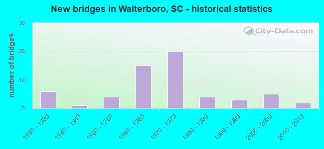
- New bridges - historical statistics
- 61930-1939
- 11940-1949
- 41950-1959
- 151960-1969
- 201970-1979
- 41980-1989
- 31990-1999
- 52000-2009
- 22010-2019
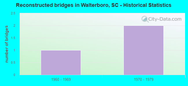
- Reconstructed bridges - Historical Statistics
- 11960-1969
- 21970-1979

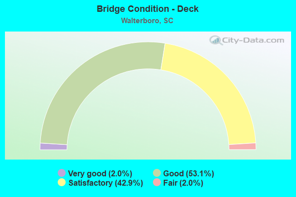
- Bridge Condition - Deck
- 2.0%Very good
- 53.1%Good
- 42.9%Satisfactory
- 2.0%Fair
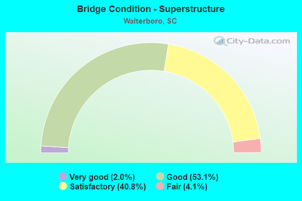
- Bridge Condition - Superstructure
- 2.0%Very good
- 53.1%Good
- 40.8%Satisfactory
- 4.1%Fair
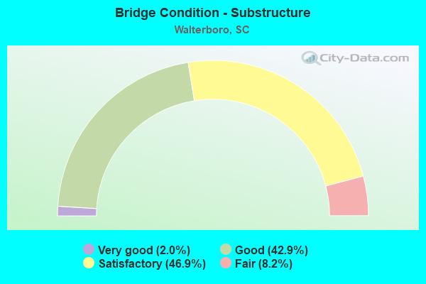
- Bridge Condition - Substructure
- 2.0%Very good
- 42.9%Good
- 46.9%Satisfactory
- 8.2%Fair
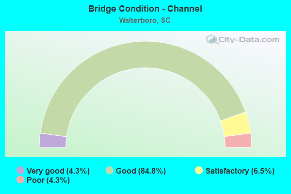
- Bridge Condition - Channel
- 4.3%Very good
- 84.8%Good
- 6.5%Satisfactory
- 4.3%Poor
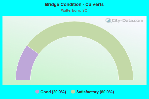
- Bridge Condition - Culverts
- 20.0%Good
- 80.0%Satisfactory
Find on map >> Show street view
Structure Number: 502, Location: 4 MI N OF WALTERBORO (Lat: 32.977067, Lng: -80.635303), Route carried "on" structure: US 15, Year Built: 1931, Status: Open, Structure Length: 1.04m (3.41ft), Average Daily Traffic: 4,100 (year 2020), Truck Traffic: 10%, Average Future Daily Traffic: 5,986 (year 2040), Features Intersected: LANGDALE BRANCH
Minimum Vertical Clearance: 30+ m (98+ ft), Kilometerpoint: 8.782, Lanes on structure: 2, Owner: State Highway Agency, Approaching Roadway Width: 7.4m (24.3ft), Material/Design: Concrete, Design/Construction: Culvert, Number Of Spans In Main Unit: 3, Length of Maximum Span: 3.0m (9.8ft), Curb-To-Curb Width: 11.9m (39.0ft), Out-to-Out Width: 17.4m (57.1ft)
Condition: Channel: Poor, Culverts: Satisfactory, Operating Rating: 37.6 metric tons, Method Used To Determine Operating Rating: Load and Resistance Factor Rating (LRFR) rating reported by rating factor(RF) method using HL-93 loadings, Inventory Rating: 29.2 metric tons, Method Used To Determine Inventory Rating: Load and Resistance Factor Rating (LRFR) rating reported by rating factor(RF) method using HL-93 loadings, Structural Evaluation: Equal to present minimum criteria, Deck Geometry: Somewhat better than minimum adequacy, Waterway Adequacy: Equal to present minimum criteria, Approach Roadway Alignment: Equal to present desirable criteria, Length Of Structure Improvement: 1.04m (3.41ft), Designated Inspection Frequency: Every 24 months, Inspection Date: March 2020
Find on map >> Show street view
Structure Number: 503, Location: 6 MI N OF WALTERBORO (Lat: 32.997878, Lng: -80.637108), Route carried "on" structure: US 15, Year Built: 1931, Year Reconstructed: 1965, Status: Open, Structure Length: 1.04m (3.41ft), Average Daily Traffic: 4,100 (year 2020), Truck Traffic: 10%, Average Future Daily Traffic: 5,986 (year 2040), Features Intersected: ALLEN CREEK
Minimum Vertical Clearance: 30+ m (98+ ft), Kilometerpoint: 11.130, Lanes on structure: 2, Owner: State Highway Agency, Approaching Roadway Width: 7.6m (24.9ft), Material/Design: Concrete, Design/Construction: Culvert, Number Of Spans In Main Unit: 3, Length of Maximum Span: 3.0m (9.8ft), Curb-To-Curb Width: 11.6m (38.1ft), Out-to-Out Width: 15.2m (49.9ft)
Condition: Channel: Satisfactory, Culverts: Satisfactory, Operating Rating: 22.4 metric tons, Method Used To Determine Operating Rating: Load and Resistance Factor Rating (LRFR) rating reported by rating factor(RF) method using HL-93 loadings, Inventory Rating: 17.2 metric tons, Method Used To Determine Inventory Rating: Load and Resistance Factor Rating (LRFR) rating reported by rating factor(RF) method using HL-93 loadings, Structural Evaluation: Meets minimum limits, Deck Geometry: Somewhat better than minimum adequacy, Waterway Adequacy: Equal to present minimum criteria, Approach Roadway Alignment: Equal to present desirable criteria, Length Of Structure Improvement: 1.04m (3.41ft), Designated Inspection Frequency: Every 24 months, Inspection Date: March 2020
Find on map >> Show street view
Structure Number: 517, Location: 2.6 MI W WALTERBORO (Lat: 32.932444, Lng: -80.700769), Route carried "on" structure: State highway 64, Year Built: 1931, Status: Open, Structure Length: 0.67m (2.20ft), Average Daily Traffic: 4,000 (year 2020), Truck Traffic: 10%, Average Future Daily Traffic: 6,360 (year 2040), Features Intersected: TRIB TO JONES SWAMP
Minimum Vertical Clearance: 30+ m (98+ ft), Kilometerpoint: 32.940, Lanes on structure: 2, Base Highway Network: Yes, Owner: State Highway Agency, Approaching Roadway Width: 7.7m (25.3ft), Material/Design: Concrete, Design/Construction: Culvert, Number Of Spans In Main Unit: 2, Length of Maximum Span: 3.0m (9.8ft), Curb-To-Curb Width: 10.4m (34.1ft), Out-to-Out Width: 11.0m (36.1ft)
Condition: Channel: Satisfactory, Culverts: Satisfactory, Operating Rating: 23.7 metric tons, Method Used To Determine Operating Rating: Load and Resistance Factor Rating (LRFR) rating reported by rating factor(RF) method using HL-93 loadings, Inventory Rating: 18.5 metric tons, Method Used To Determine Inventory Rating: Load and Resistance Factor Rating (LRFR) rating reported by rating factor(RF) method using HL-93 loadings, Structural Evaluation: Somewhat better than minimum adequacy, Deck Geometry: Somewhat better than minimum adequacy, Waterway Adequacy: Equal to present desirable criteria, Approach Roadway Alignment: Equal to present desirable criteria, Length Of Structure Improvement: 0.67m (2.20ft), Designated Inspection Frequency: Every 24 months, Inspection Date: March 2020
Find on map >> Show street view
Structure Number: 724, Location: CHESTERFIELD CITY LIMITS (Lat: 34.728831, Lng: -80.091603), Route carried "on" structure: State highway 145, Year Built: 1936, Status: Open, Structure Length: 1.04m (3.41ft), Average Daily Traffic: 1,950 (year 2020), Truck Traffic: 12%, Average Future Daily Traffic: 2,847 (year 2040), Design Load: H 15, Features Intersected: INDIAN CREEK
Minimum Vertical Clearance: 30+ m (98+ ft), Kilometerpoint: 31.461, Lanes on structure: 2, Owner: State Highway Agency, Approaching Roadway Width: 8.2m (26.9ft), Material/Design: Concrete, Design/Construction: Culvert, Number Of Spans In Main Unit: 3, Length of Maximum Span: 3.0m (9.8ft), Curb-To-Curb Width: 10.1m (33.1ft), Out-to-Out Width: 10.3m (33.8ft)
Condition: Channel: Satisfactory, Culverts: Satisfactory, Operating Rating: 6.5 metric tons, Method Used To Determine Operating Rating: Load and Resistance Factor Rating (LRFR) rating reported by rating factor(RF) method using HL-93 loadings, Inventory Rating: 4.9 metric tons, Method Used To Determine Inventory Rating: Load and Resistance Factor Rating (LRFR) rating reported by rating factor(RF) method using HL-93 loadings, Structural Evaluation: High priority of replacement, Deck Geometry: Somewhat better than minimum adequacy, Waterway Adequacy: Equal to present minimum criteria, Approach Roadway Alignment: Equal to present desirable criteria, Length Of Structure Improvement: 1.69m (5.54ft), Designated Inspection Frequency: Every 24 months, Inspection Date: December 2021, Bridge Improvement Cost: $170,000, Roadway Improvement Cost: $43,000, Total Project Cost: $255,000 ( Estimate for 2021)
Find on map >> Show street view
Structure Number: 854, Location: @ WALTERBORO (Lat: 32.890100, Lng: -80.685753), Route carried "on" structure: Alternate US 17, Year Built: 1938, Year Reconstructed: 1970, Status: Open, Structure Length: 6.40m (21.00ft), Average Daily Traffic: 10,900 (year 2020), Truck Traffic: 9%, Average Future Daily Traffic: 15,369 (year 2040), Design Load: H 15, Features Intersected: IRELAND CREEK
Minimum Vertical Clearance: 30+ m (98+ ft), Kilometerpoint: 27.550, Lanes on structure: 4, Owner: State Highway Agency, Approaching Roadway Width: 15.2m (49.9ft), Material/Design: Concrete, Design/Construction: Tee Beam, Number Of Spans In Main Unit: 7, Length of Maximum Span: 9.1m (29.9ft), Curb or Sidewalk Widths: Left: 0.5m (1.6ft), Right: 0.5m (1.6ft), Curb-To-Curb Width: 15.2m (49.9ft), Out-to-Out Width: 16.8m (55.1ft)
Condition: Deck: Good, Superstructure: Fair, Substructure: Good, Channel: Good, Operating Rating: 35.3 metric tons, Method Used To Determine Operating Rating: Load and Resistance Factor Rating (LRFR) rating reported by rating factor(RF) method using HL-93 loadings, Inventory Rating: 27.2 metric tons, Method Used To Determine Inventory Rating: Load and Resistance Factor Rating (LRFR) rating reported by rating factor(RF) method using HL-93 loadings, Structural Evaluation: Somewhat better than minimum adequacy, Deck Geometry: High priority of corrective action, Waterway Adequacy: Equal to present minimum criteria, Approach Roadway Alignment: Equal to present desirable criteria, Length Of Structure Improvement: 7.39m (24.25ft), Designated Inspection Frequency: Every 24 months, Inspection Date: January 2021, Bridge Improvement Cost: $147,000, Roadway Improvement Cost: $37,000, Total Project Cost: $221,000 ( Estimate for 2021), Deck Structure Type: Concrete Cast-file-Place, Wearing Surface/Protective System: Wearing Surface: Bituminous
Find on map >> Show street view
Structure Number: 855, Location: IN WALTERBORO (Lat: 32.891139, Lng: -80.683497), Route carried "on" structure: Alternate US 17, Year Built: 1938, Year Reconstructed: 1970, Status: Open, Structure Length: 2.74m (8.99ft), Average Daily Traffic: 11,800 (year 2021), Truck Traffic: 9%, Average Future Daily Traffic: 16,638 (year 2041), Design Load: H 15, Features Intersected: GREAT SWAMP
Minimum Vertical Clearance: 30+ m (98+ ft), Kilometerpoint: 27.822, Lanes on structure: 4, Owner: State Highway Agency, Approaching Roadway Width: 15.2m (49.9ft), Material/Design: Concrete, Design/Construction: Tee Beam, Number Of Spans In Main Unit: 3, Length of Maximum Span: 9.1m (29.9ft), Curb or Sidewalk Widths: Left: 0.5m (1.6ft), Right: 0.5m (1.6ft), Curb-To-Curb Width: 15.2m (49.9ft), Out-to-Out Width: 16.8m (55.1ft)
Condition: Deck: Good, Superstructure: Satisfactory, Substructure: Satisfactory, Channel: Good, Operating Rating: 36.0 metric tons, Method Used To Determine Operating Rating: Load and Resistance Factor Rating (LRFR) rating reported by rating factor(RF) method using HL-93 loadings, Inventory Rating: 27.5 metric tons, Method Used To Determine Inventory Rating: Load and Resistance Factor Rating (LRFR) rating reported by rating factor(RF) method using HL-93 loadings, Structural Evaluation: Equal to present minimum criteria, Deck Geometry: High priority of corrective action, Waterway Adequacy: Equal to present minimum criteria, Approach Roadway Alignment: Equal to present desirable criteria, Length Of Structure Improvement: 3.57m (11.71ft), Designated Inspection Frequency: Every 24 months, Inspection Date: January 2022, Bridge Improvement Cost: $71,000, Roadway Improvement Cost: $18,000, Total Project Cost: $107,000 ( Estimate for 2022), Deck Structure Type: Concrete Cast-file-Place, Wearing Surface/Protective System: Wearing Surface: Bituminous
Find on map >> Show street view
Structure Number: 1359, Location: 2.8 MI NW OF WALTERBORO (Lat: 32.937161, Lng: -80.683931), Route carried "on" structure: State highway 24, Year Built: 1947, Status: Open, Structure Length: 0.70m (2.30ft), Average Daily Traffic: 3,000 (year 2020), Truck Traffic: 6%, Average Future Daily Traffic: 4,230 (year 2040), Design Load: H 15, Features Intersected: WOLF CREEK
Minimum Vertical Clearance: 30+ m (98+ ft), Kilometerpoint: 1.059, Lanes on structure: 2, Owner: State Highway Agency, Approaching Roadway Width: 7.9m (25.9ft), Material/Design: Concrete, Design/Construction: Culvert, Number Of Spans In Main Unit: 2, Length of Maximum Span: 3.0m (9.8ft), Curb-To-Curb Width: 7.9m (25.9ft), Out-to-Out Width: 10.4m (34.1ft)
Condition: Channel: Good, Culverts: Good, Operating Rating: 43.7 metric tons, Method Used To Determine Operating Rating: Load and Resistance Factor Rating (LRFR) rating reported by rating factor(RF) method using HL-93 loadings, Inventory Rating: 33.7 metric tons, Method Used To Determine Inventory Rating: Load and Resistance Factor Rating (LRFR) rating reported by rating factor(RF) method using HL-93 loadings, Structural Evaluation: Better than present minimum criteria, Deck Geometry: High priority of corrective action, Waterway Adequacy: Equal to present minimum criteria, Approach Roadway Alignment: Equal to present desirable criteria, Length Of Structure Improvement: 1.32m (4.33ft), Designated Inspection Frequency: Every 24 months, Inspection Date: March 2021, Bridge Improvement Cost: $60,000, Roadway Improvement Cost: $15,000, Total Project Cost: $90,000 ( Estimate for 2021)
Find on map >> Show street view
Structure Number: 1615, Location: IN WALTERBORO (Lat: 32.908203, Lng: -80.667253), Route carried "on" structure: US 15, Year Built: 1997, Status: Open, Structure Length: 3.08m (10.10ft), Average Daily Traffic: 10,000 (year 2020), Truck Traffic: 4%, Average Future Daily Traffic: 14,100 (year 2040), Design Load: HS 20+Mod, Features Intersected: IRELAND CREEK
Minimum Vertical Clearance: 30+ m (98+ ft), Kilometerpoint: 0.409, Lanes on structure: 5, Owner: State Highway Agency, Approaching Roadway Width: 22.7m (74.5ft), Skew: 10 degrees, Material/Design: Concrete continuous, Design/Construction: Slab, Number Of Spans In Main Unit: 3, Length of Maximum Span: 11.3m (37.1ft), Curb or Sidewalk Widths: Left: 1.5m (4.9ft), Right: 1.5m (4.9ft), Curb-To-Curb Width: 22.7m (74.5ft), Out-to-Out Width: 26.4m (86.6ft)
Condition: Deck: Satisfactory, Superstructure: Satisfactory, Substructure: Satisfactory, Channel: Good, Operating Rating: 63.5 metric tons, Method Used To Determine Operating Rating: Load and Resistance Factor Rating (LRFR) rating reported by rating factor(RF) method using HL-93 loadings, Inventory Rating: 48.9 metric tons, Method Used To Determine Inventory Rating: Load and Resistance Factor Rating (LRFR) rating reported by rating factor(RF) method using HL-93 loadings, Structural Evaluation: Equal to present minimum criteria, Deck Geometry: Equal to present minimum criteria, Waterway Adequacy: Equal to present minimum criteria, Approach Roadway Alignment: Equal to present desirable criteria, Length Of Structure Improvement: 3.08m (10.10ft), Designated Inspection Frequency: Every 24 months, Inspection Date: March 2020, Deck Structure Type: Concrete Cast-file-Place, Wearing Surface/Protective System: Wearing Surface: Monolithic Concrete
Find on map >> Show street view
Structure Number: 1813, Location: 4.5 MI NW OF WALTERBORO (Lat: 32.958786, Lng: -80.704272), Route carried "on" structure: State highway 49, Year Built: 1999, Status: Open, Structure Length: 1.40m (4.59ft), Average Daily Traffic: 700 (year 2020), Truck Traffic: 11%, Average Future Daily Traffic: 1,022 (year 2040), Design Load: HS 25 or greater, Features Intersected: JONES SWAMP
Minimum Vertical Clearance: 30+ m (98+ ft), Kilometerpoint: 0.721, Lanes on structure: 2, Owner: State Highway Agency, Approaching Roadway Width: 7.6m (24.9ft), Material/Design: Concrete continuous, Design/Construction: Slab, Number Of Spans In Main Unit: 2, Length of Maximum Span: 7.0m (23.0ft), Curb-To-Curb Width: 10.2m (33.5ft), Out-to-Out Width: 11.1m (36.4ft)
Condition: Deck: Good, Superstructure: Good, Substructure: Good, Channel: Good, Operating Rating: 52.2 metric tons, Method Used To Determine Operating Rating: Load and Resistance Factor Rating (LRFR) rating reported by rating factor(RF) method using HL-93 loadings, Inventory Rating: 40.2 metric tons, Method Used To Determine Inventory Rating: Load and Resistance Factor Rating (LRFR) rating reported by rating factor(RF) method using HL-93 loadings, Structural Evaluation: Better than present minimum criteria, Deck Geometry: Equal to present minimum criteria, Waterway Adequacy: Equal to present minimum criteria, Approach Roadway Alignment: Equal to present desirable criteria, Length Of Structure Improvement: 1.40m (4.59ft), Designated Inspection Frequency: Every 24 months, Inspection Date: March 2021, Deck Structure Type: Concrete Cast-file-Place, Wearing Surface/Protective System: Wearing Surface: Monolithic Concrete
Find on map >> Show street view
Structure Number: 1814, Location: 4.6 MI NW OF WALTERBORO (Lat: 32.958792, Lng: -80.704906), Route carried "on" structure: State highway 49, Year Built: 1999, Status: Open, Structure Length: 2.10m (6.89ft), Average Daily Traffic: 700 (year 2020), Truck Traffic: 11%, Average Future Daily Traffic: 1,022 (year 2040), Design Load: HS 25 or greater, Features Intersected: JONES SWAMP
Minimum Vertical Clearance: 30+ m (98+ ft), Kilometerpoint: 0.777, Lanes on structure: 2, Owner: State Highway Agency, Approaching Roadway Width: 7.6m (24.9ft), Material/Design: Concrete continuous, Design/Construction: Slab, Number Of Spans In Main Unit: 3, Length of Maximum Span: 7.0m (23.0ft), Curb-To-Curb Width: 10.2m (33.5ft), Out-to-Out Width: 11.1m (36.4ft)
Condition: Deck: Good, Superstructure: Good, Substructure: Good, Channel: Good, Operating Rating: 55.7 metric tons, Method Used To Determine Operating Rating: Load and Resistance Factor Rating (LRFR) rating reported by rating factor(RF) method using HL-93 loadings, Inventory Rating: 42.8 metric tons, Method Used To Determine Inventory Rating: Load and Resistance Factor Rating (LRFR) rating reported by rating factor(RF) method using HL-93 loadings, Structural Evaluation: Better than present minimum criteria, Deck Geometry: Equal to present minimum criteria, Waterway Adequacy: Equal to present minimum criteria, Approach Roadway Alignment: Equal to present minimum criteria, Length Of Structure Improvement: 2.10m (6.89ft), Designated Inspection Frequency: Every 24 months, Inspection Date: March 2021, Deck Structure Type: Concrete Cast-file-Place, Wearing Surface/Protective System: Wearing Surface: Monolithic Concrete
Find on map >> Show street view
Structure Number: 2021, Location: 3 MI WNW WALTERBORO (Lat: 32.912022, Lng: -80.731678), Route carried "on" structure: State highway 51, Year Built: 1954, Status: Open, Structure Length: 0.85m (2.79ft), Average Daily Traffic: 475 (year 2020), Truck Traffic: 5%, Average Future Daily Traffic: 608 (year 2040), Design Load: H 10, Features Intersected: TRIB TO DOCTORS CREEK
Minimum Vertical Clearance: 30+ m (98+ ft), Kilometerpoint: 4.366, Lanes on structure: 2, Owner: State Highway Agency, Approaching Roadway Width: 6.6m (21.7ft), Material/Design: Concrete, Design/Construction: Slab, Number Of Spans In Main Unit: 2, Length of Maximum Span: 4.3m (14.1ft), Curb or Sidewalk Widths: Left: 0.2m (0.7ft), Right: 0.2m (0.7ft), Curb-To-Curb Width: 7.3m (24.0ft), Out-to-Out Width: 7.8m (25.6ft)
Condition: Deck: Satisfactory, Superstructure: Satisfactory, Substructure: Good, Channel: Good, Operating Rating: 21.4 metric tons, Method Used To Determine Operating Rating: Load and Resistance Factor Rating (LRFR) rating reported by rating factor(RF) method using HL-93 loadings, Inventory Rating: 16.5 metric tons, Method Used To Determine Inventory Rating: Load and Resistance Factor Rating (LRFR) rating reported by rating factor(RF) method using HL-93 loadings, Structural Evaluation: Somewhat better than minimum adequacy, Deck Geometry: Meets minimum limits, Waterway Adequacy: Equal to present minimum criteria, Approach Roadway Alignment: Equal to present desirable criteria, Bridge Posting: Required (Relationship of Operating Rating to Maximum Legal Load: 20.0 - 29.9% below), Length Of Structure Improvement: 0.85m (2.79ft), Designated Inspection Frequency: Every 24 months, Inspection Date: January 2021, Deck Structure Type: Concrete Precast Panels, Wearing Surface/Protective System: Wearing Surface: Bituminous
Find on map >> Show street view
Structure Number: 2022, Location: 2MI WNW WALT'B (Lat: 32.891192, Lng: -80.697181), Route carried "on" structure: State highway 51, Year Built: 1954, Status: Open, Structure Length: 1.28m (4.20ft), Average Daily Traffic: 500 (year 2021), Truck Traffic: 5%, Average Future Daily Traffic: 705 (year 2041), Design Load: H 10, Features Intersected: TRIB TO ASHEPOO RIVER
Minimum Vertical Clearance: 30+ m (98+ ft), Kilometerpoint: 8.446, Lanes on structure: 2, Owner: State Highway Agency, Approaching Roadway Width: 6.1m (20.0ft), Material/Design: Concrete, Design/Construction: Slab, Number Of Spans In Main Unit: 3, Length of Maximum Span: 4.3m (14.1ft), Curb or Sidewalk Widths: Left: 0.2m (0.7ft), Right: 0.2m (0.7ft), Curb-To-Curb Width: 7.3m (24.0ft), Out-to-Out Width: 7.8m (25.6ft)
Condition: Deck: Satisfactory, Superstructure: Satisfactory, Substructure: Satisfactory, Channel: Poor, Operating Rating: 21.7 metric tons, Method Used To Determine Operating Rating: Load and Resistance Factor Rating (LRFR) rating reported by rating factor(RF) method using HL-93 loadings, Inventory Rating: 16.8 metric tons, Method Used To Determine Inventory Rating: Load and Resistance Factor Rating (LRFR) rating reported by rating factor(RF) method using HL-93 loadings, Structural Evaluation: Somewhat better than minimum adequacy, Deck Geometry: Meets minimum limits, Waterway Adequacy: Equal to present minimum criteria, Approach Roadway Alignment: Equal to present desirable criteria, Bridge Posting: Required (Relationship of Operating Rating to Maximum Legal Load: 20.0 - 29.9% below), Length Of Structure Improvement: 1.28m (4.20ft), Designated Inspection Frequency: Every 24 months, Inspection Date: January 2022, Deck Structure Type: Concrete Precast Panels, Wearing Surface/Protective System: Wearing Surface: Bituminous
Find on map >> Show street view
Structure Number: 2162, Location: 4.3 MI NE WALT'B (Lat: 32.931842, Lng: -80.599578), Route carried "on" structure: State highway 65, Year Built: 2005, Status: Open, Structure Length: 1.22m (4.00ft), Average Daily Traffic: 900 (year 2020), Truck Traffic: 9%, Average Future Daily Traffic: 1,314 (year 2040), Design Load: HS 20, Features Intersected: SHEREAU BRANCH
Minimum Vertical Clearance: 30+ m (98+ ft), Kilometerpoint: 7.741, Lanes on structure: 2, Owner: State Highway Agency, Approaching Roadway Width: 6.1m (20.0ft), Material/Design: Prestressed concrete, Design/Construction: Slab, Number Of Spans In Main Unit: 1, Length of Maximum Span: 12.2m (40.0ft), Curb-To-Curb Width: 10.1m (33.1ft), Out-to-Out Width: 11.0m (36.1ft)
Condition: Deck: Good, Superstructure: Good, Substructure: Good, Channel: Good, Operating Rating: 62.5 metric tons, Method Used To Determine Operating Rating: Load and Resistance Factor Rating (LRFR) rating reported by rating factor(RF) method using HL-93 loadings, Inventory Rating: 45.7 metric tons, Method Used To Determine Inventory Rating: Load and Resistance Factor Rating (LRFR) rating reported by rating factor(RF) method using HL-93 loadings, Structural Evaluation: Better than present minimum criteria, Deck Geometry: Equal to present minimum criteria, Waterway Adequacy: Equal to present minimum criteria, Approach Roadway Alignment: Equal to present desirable criteria, Length Of Structure Improvement: 1.22m (4.00ft), Designated Inspection Frequency: Every 24 months, Inspection Date: Febuary 2021, Deck Structure Type: Concrete Precast Panels, Wearing Surface/Protective System: Wearing Surface: Bituminous
Find on map >> Show street view
Structure Number: 2317, Location: 7.2 MI NE WALT'B (Lat: 33.002906, Lng: -80.640619), Route carried "on" structure: State highway 34, Year Built: 2005, Status: Open, Structure Length: 0.91m (2.99ft), Average Daily Traffic: 600 (year 2020), Truck Traffic: 14%, Average Future Daily Traffic: 876 (year 2040), Design Load: HL 93, Features Intersected: TRIB TO ALLEN CREEK
Minimum Vertical Clearance: 30+ m (98+ ft), Kilometerpoint: 5.930, Lanes on structure: 2, Owner: State Highway Agency, Approaching Roadway Width: 7.3m (24.0ft), Material/Design: Concrete, Design/Construction: Slab, Number Of Spans In Main Unit: 1, Length of Maximum Span: 9.1m (29.9ft), Curb or Sidewalk Widths: Left: 0.2m (0.7ft), Right: 0.2m (0.7ft), Curb-To-Curb Width: 10.4m (34.1ft), Out-to-Out Width: 11.3m (37.1ft)
Condition: Deck: Good, Superstructure: Good, Substructure: Good, Channel: Good, Operating Rating: 51.5 metric tons, Method Used To Determine Operating Rating: Load and Resistance Factor Rating (LRFR) rating reported by rating factor(RF) method using HL-93 loadings, Inventory Rating: 39.9 metric tons, Method Used To Determine Inventory Rating: Load and Resistance Factor Rating (LRFR) rating reported by rating factor(RF) method using HL-93 loadings, Structural Evaluation: Better than present minimum criteria, Deck Geometry: Equal to present minimum criteria, Waterway Adequacy: Equal to present minimum criteria, Approach Roadway Alignment: Equal to present desirable criteria, Length Of Structure Improvement: 0.91m (2.99ft), Designated Inspection Frequency: Every 24 months, Inspection Date: March 2021, Deck Structure Type: Concrete Cast-file-Place, Wearing Surface/Protective System: Wearing Surface: Monolithic Concrete
Find on map >> Show street view
Structure Number: 2318, Location: 7 MI NE WALT'B (Lat: 33.002083, Lng: -80.652761), Route carried "on" structure: State highway 34, Year Built: 2005, Status: Open, Structure Length: 2.26m (7.41ft), Average Daily Traffic: 600 (year 2020), Truck Traffic: 14%, Average Future Daily Traffic: 876 (year 2040), Design Load: HL 93, Features Intersected: ALLEN CREEK
Minimum Vertical Clearance: 30+ m (98+ ft), Kilometerpoint: 7.099, Lanes on structure: 2, Owner: State Highway Agency, Approaching Roadway Width: 6.7m (22.0ft), Material/Design: Concrete continuous, Design/Construction: Slab, Number Of Spans In Main Unit: 3, Length of Maximum Span: 9.1m (29.9ft), Curb-To-Curb Width: 10.4m (34.1ft), Out-to-Out Width: 11.3m (37.1ft)
Condition: Deck: Good, Superstructure: Good, Substructure: Good, Channel: Good, Operating Rating: 53.8 metric tons, Method Used To Determine Operating Rating: Load and Resistance Factor Rating (LRFR) rating reported by rating factor(RF) method using HL-93 loadings, Inventory Rating: 41.5 metric tons, Method Used To Determine Inventory Rating: Load and Resistance Factor Rating (LRFR) rating reported by rating factor(RF) method using HL-93 loadings, Structural Evaluation: Better than present minimum criteria, Deck Geometry: Equal to present minimum criteria, Waterway Adequacy: Equal to present minimum criteria, Approach Roadway Alignment: Equal to present desirable criteria, Length Of Structure Improvement: 2.26m (7.41ft), Designated Inspection Frequency: Every 24 months, Inspection Date: March 2021, Deck Structure Type: Concrete Cast-file-Place, Wearing Surface/Protective System: Wearing Surface: Monolithic Concrete
Find on map >> Show street view
Structure Number: 2709, Location: 3.1 MI N OF WALTERBORO (Lat: 32.945683, Lng: -80.680661), Route carried "on" structure: State highway 129, Year Built: 2010, Status: Open, Structure Length: 2.29m (7.51ft), Average Daily Traffic: 100 (year 2020), Truck Traffic: 5%, Average Future Daily Traffic: 128 (year 2040), Design Load: HL 93, Features Intersected: WOLF CREEK
Minimum Vertical Clearance: 30+ m (98+ ft), Kilometerpoint: 0.991, Lanes on structure: 2, Owner: State Highway Agency, Approaching Roadway Width: 6.1m (20.0ft), Material/Design: Prestressed concrete, Design/Construction: Stringer/Multi-beam, Number Of Spans In Main Unit: 1, Length of Maximum Span: 22.9m (75.1ft), Curb-To-Curb Width: 10.4m (34.1ft), Out-to-Out Width: 11.3m (37.1ft)
Condition: Deck: Good, Superstructure: Good, Substructure: Good, Channel: Very good, Operating Rating: 52.8 metric tons, Method Used To Determine Operating Rating: Load and Resistance Factor Rating (LRFR) rating reported by rating factor(RF) method using HL-93 loadings, Inventory Rating: 26.9 metric tons, Method Used To Determine Inventory Rating: Load and Resistance Factor Rating (LRFR) rating reported by rating factor(RF) method using HL-93 loadings, Structural Evaluation: Equal to present minimum criteria, Deck Geometry: Superior to present desirable criteria, Waterway Adequacy: Equal to present minimum criteria, Approach Roadway Alignment: Equal to present desirable criteria, Length Of Structure Improvement: 2.29m (7.51ft), Designated Inspection Frequency: Every 24 months, Inspection Date: March 2021, Deck Structure Type: Concrete Cast-file-Place, Wearing Surface/Protective System: Wearing Surface: Monolithic Concrete
Find on map >> Show street view
Structure Number: 271, Location: 4.5 MI SW WALTERBORO (Lat: 32.848908, Lng: -80.708517), Route carried "on" structure: State highway 233, Year Built: 1958, Status: Open, Structure Length: 0.85m (2.79ft), Average Daily Traffic: 250 (year 2020), Truck Traffic: 5%, Average Future Daily Traffic: 320 (year 2040), Design Load: H 15, Features Intersected: TRIB TO ASHEPOO RIVER
Minimum Vertical Clearance: 30+ m (98+ ft), Kilometerpoint: 2.414, Lanes on structure: 2, Owner: State Highway Agency, Approaching Roadway Width: 5.8m (19.0ft), Material/Design: Concrete, Design/Construction: Slab, Number Of Spans In Main Unit: 2, Length of Maximum Span: 4.3m (14.1ft), Curb-To-Curb Width: 7.9m (25.9ft), Out-to-Out Width: 8.4m (27.6ft)
Condition: Deck: Satisfactory, Superstructure: Satisfactory, Substructure: Satisfactory, Channel: Good, Operating Rating: 31.1 metric tons, Method Used To Determine Operating Rating: Load and Resistance Factor Rating (LRFR) rating reported by rating factor(RF) method using HL-93 loadings, Inventory Rating: 24.0 metric tons, Method Used To Determine Inventory Rating: Load and Resistance Factor Rating (LRFR) rating reported by rating factor(RF) method using HL-93 loadings, Structural Evaluation: Equal to present minimum criteria, Deck Geometry: Somewhat better than minimum adequacy, Waterway Adequacy: Equal to present minimum criteria, Approach Roadway Alignment: Equal to present desirable criteria, Length Of Structure Improvement: 0.85m (2.79ft), Designated Inspection Frequency: Every 24 months, Inspection Date: January 2021, Deck Structure Type: Concrete Precast Panels, Wearing Surface/Protective System: Wearing Surface: Bituminous
Find on map >> Show street view
Structure Number: 2711, Location: 5.3 MI SW WALT'B (Lat: 32.839622, Lng: -80.721328), Route carried "on" structure: State highway 233, Year Built: 1958, Status: Open, Structure Length: 0.85m (2.79ft), Average Daily Traffic: 250 (year 2020), Truck Traffic: 5%, Average Future Daily Traffic: 320 (year 2040), Design Load: H 15, Features Intersected: REMICH SWAMP
Minimum Vertical Clearance: 30+ m (98+ ft), Kilometerpoint: 3.972, Lanes on structure: 2, Owner: State Highway Agency, Approaching Roadway Width: 6.0m (19.7ft), Material/Design: Concrete, Design/Construction: Slab, Number Of Spans In Main Unit: 2, Length of Maximum Span: 4.3m (14.1ft), Curb-To-Curb Width: 7.9m (25.9ft), Out-to-Out Width: 8.4m (27.6ft)
Condition: Deck: Good, Superstructure: Good, Substructure: Fair, Channel: Good, Operating Rating: 36.0 metric tons, Method Used To Determine Operating Rating: Load and Resistance Factor Rating (LRFR) rating reported by rating factor(RF) method using HL-93 loadings, Inventory Rating: 27.5 metric tons, Method Used To Determine Inventory Rating: Load and Resistance Factor Rating (LRFR) rating reported by rating factor(RF) method using HL-93 loadings, Structural Evaluation: Somewhat better than minimum adequacy, Deck Geometry: Somewhat better than minimum adequacy, Waterway Adequacy: Equal to present minimum criteria, Approach Roadway Alignment: Equal to present desirable criteria, Length Of Structure Improvement: 0.85m (2.79ft), Designated Inspection Frequency: Every 24 months, Inspection Date: January 2021, Deck Structure Type: Concrete Precast Panels, Wearing Surface/Protective System: Wearing Surface: Bituminous
Find on map >> Show street view
Structure Number: 2712, Location: 6 MI SW WALTERBORO (Lat: 32.830294, Lng: -80.730875), Route carried "on" structure: State highway 233, Year Built: 2007, Status: Open, Structure Length: 1.52m (4.99ft), Average Daily Traffic: 250 (year 2020), Truck Traffic: 5%, Average Future Daily Traffic: 320 (year 2040), Design Load: HS 20, Features Intersected: REMICH SWAMP
Minimum Vertical Clearance: 30+ m (98+ ft), Kilometerpoint: 5.337, Lanes on structure: 2, Owner: State Highway Agency, Approaching Roadway Width: 5.7m (18.7ft), Material/Design: Prestressed concrete, Design/Construction: Box Beam or Girders - Multiple, Number Of Spans In Main Unit: 1, Length of Maximum Span: 15.2m (49.9ft), Curb-To-Curb Width: 10.1m (33.1ft), Out-to-Out Width: 11.0m (36.1ft)
Condition: Deck: Good, Superstructure: Good, Substructure: Good, Channel: Good, Operating Rating: 53.8 metric tons, Method Used To Determine Operating Rating: Load and Resistance Factor Rating (LRFR) rating reported by rating factor(RF) method using HL-93 loadings, Inventory Rating: 37.3 metric tons, Method Used To Determine Inventory Rating: Load and Resistance Factor Rating (LRFR) rating reported by rating factor(RF) method using HL-93 loadings, Structural Evaluation: Better than present minimum criteria, Deck Geometry: Better than present minimum criteria, Waterway Adequacy: Equal to present minimum criteria, Approach Roadway Alignment: Equal to present desirable criteria, Length Of Structure Improvement: 1.52m (4.99ft), Designated Inspection Frequency: Every 24 months, Inspection Date: January 2021, Deck Structure Type: Concrete Precast Panels, Wearing Surface/Protective System: Wearing Surface: Bituminous
Find on map >> Show street view
Structure Number: 3239, Location: 2.8 MI E WALT'B (Lat: 32.912219, Lng: -80.621108), Route carried "on" structure: State highway 124, Year Built: 1960, Status: Open, Structure Length: 1.28m (4.20ft), Average Daily Traffic: 1,500 (year 2020), Truck Traffic: 5%, Average Future Daily Traffic: 1,920 (year 2040), Design Load: H 15, Features Intersected: UNNAMED STREAM
Minimum Vertical Clearance: 30+ m (98+ ft), Kilometerpoint: 0.930, Lanes on structure: 2, Owner: State Highway Agency, Approaching Roadway Width: 6.1m (20.0ft), Material/Design: Concrete, Design/Construction: Slab, Number Of Spans In Main Unit: 3, Length of Maximum Span: 4.3m (14.1ft), Curb-To-Curb Width: 7.9m (25.9ft), Out-to-Out Width: 8.4m (27.6ft)
Condition: Deck: Satisfactory, Superstructure: Satisfactory, Substructure: Satisfactory, Channel: Good, Operating Rating: 34.0 metric tons, Method Used To Determine Operating Rating: Load and Resistance Factor Rating (LRFR) rating reported by rating factor(RF) method using HL-93 loadings, Inventory Rating: 26.2 metric tons, Method Used To Determine Inventory Rating: Load and Resistance Factor Rating (LRFR) rating reported by rating factor(RF) method using HL-93 loadings, Structural Evaluation: Equal to present minimum criteria, Deck Geometry: Meets minimum limits, Waterway Adequacy: Equal to present minimum criteria, Approach Roadway Alignment: Equal to present desirable criteria, Length Of Structure Improvement: 1.28m (4.20ft), Designated Inspection Frequency: Every 24 months, Inspection Date: January 2021, Deck Structure Type: Concrete Precast Panels, Wearing Surface/Protective System: Wearing Surface: Bituminous
Find on map >> Show street view
Structure Number: 324, Location: 4 MI W WALTERBORO (Lat: 32.902772, Lng: -80.737025), Route carried "on" structure: State highway 126, Year Built: 1960, Status: Open, Structure Length: 1.28m (4.20ft), Average Daily Traffic: 300 (year 2020), Truck Traffic: 8%, Average Future Daily Traffic: 417 (year 2040), Design Load: H 15, Features Intersected: TRIB TO DOCTOR CREEK
Minimum Vertical Clearance: 30+ m (98+ ft), Kilometerpoint: 1.690, Lanes on structure: 2, Owner: State Highway Agency, Approaching Roadway Width: 5.9m (19.4ft), Material/Design: Concrete, Design/Construction: Slab, Number Of Spans In Main Unit: 3, Length of Maximum Span: 4.3m (14.1ft), Curb-To-Curb Width: 7.9m (25.9ft), Out-to-Out Width: 8.4m (27.6ft)
Condition: Deck: Good, Superstructure: Good, Substructure: Good, Channel: Good, Operating Rating: 34.0 metric tons, Method Used To Determine Operating Rating: Load and Resistance Factor Rating (LRFR) rating reported by rating factor(RF) method using HL-93 loadings, Inventory Rating: 26.2 metric tons, Method Used To Determine Inventory Rating: Load and Resistance Factor Rating (LRFR) rating reported by rating factor(RF) method using HL-93 loadings, Structural Evaluation: Equal to present minimum criteria, Deck Geometry: Somewhat better than minimum adequacy, Waterway Adequacy: Equal to present minimum criteria, Approach Roadway Alignment: Equal to present desirable criteria, Length Of Structure Improvement: 1.28m (4.20ft), Designated Inspection Frequency: Every 24 months, Inspection Date: March 2021, Deck Structure Type: Concrete Precast Panels, Wearing Surface/Protective System: Wearing Surface: Bituminous
Find on map >> Show street view
Structure Number: 3241, Location: 2.3 MI E WALT'B (Lat: 32.907139, Lng: -80.625797), Route carried "on" structure: State highway 132, Year Built: 1960, Status: Open, Structure Length: 1.28m (4.20ft), Average Daily Traffic: 1,150 (year 2020), Truck Traffic: 5%, Average Future Daily Traffic: 1,472 (year 2040), Design Load: H 15, Features Intersected: UNNAMED STREAM
Minimum Vertical Clearance: 30+ m (98+ ft), Kilometerpoint: 1.688, Lanes on structure: 2, Owner: State Highway Agency, Approaching Roadway Width: 5.9m (19.4ft), Material/Design: Concrete, Design/Construction: Slab, Number Of Spans In Main Unit: 3, Length of Maximum Span: 4.3m (14.1ft), Curb-To-Curb Width: 7.9m (25.9ft), Out-to-Out Width: 8.4m (27.6ft)
Condition: Deck: Satisfactory, Superstructure: Satisfactory, Substructure: Satisfactory, Channel: Good, Operating Rating: 33.7 metric tons, Method Used To Determine Operating Rating: Load and Resistance Factor Rating (LRFR) rating reported by rating factor(RF) method using HL-93 loadings, Inventory Rating: 25.9 metric tons, Method Used To Determine Inventory Rating: Load and Resistance Factor Rating (LRFR) rating reported by rating factor(RF) method using HL-93 loadings, Structural Evaluation: Equal to present minimum criteria, Deck Geometry: Meets minimum limits, Waterway Adequacy: Equal to present minimum criteria, Approach Roadway Alignment: Equal to present desirable criteria, Length Of Structure Improvement: 1.28m (4.20ft), Designated Inspection Frequency: Every 24 months, Inspection Date: January 2021, Deck Structure Type: Concrete Precast Panels, Wearing Surface/Protective System: Wearing Surface: Bituminous
Find on map >> Show street view
Structure Number: 3624, Location: 6.1 MI NE WALT'B (Lat: 32.962075, Lng: -80.588317), Route carried "on" structure: State highway 146, Year Built: 1961, Status: Open, Structure Length: 0.91m (2.99ft), Average Daily Traffic: 300 (year 2020), Truck Traffic: 5%, Average Future Daily Traffic: 384 (year 2040), Design Load: H 15, Features Intersected: UNNAMED STREAM
Minimum Vertical Clearance: 30+ m (98+ ft), Kilometerpoint: 1.334, Lanes on structure: 2, Owner: State Highway Agency, Approaching Roadway Width: 5.8m (19.0ft), Material/Design: Concrete, Design/Construction: Slab, Number Of Spans In Main Unit: 2, Length of Maximum Span: 4.6m (15.1ft), Curb-To-Curb Width: 7.9m (25.9ft), Out-to-Out Width: 8.4m (27.6ft)
Condition: Deck: Good, Superstructure: Good, Substructure: Good, Channel: Good, Operating Rating: 31.8 metric tons, Method Used To Determine Operating Rating: Load and Resistance Factor Rating (LRFR) rating reported by rating factor(RF) method using HL-93 loadings, Inventory Rating: 24.3 metric tons, Method Used To Determine Inventory Rating: Load and Resistance Factor Rating (LRFR) rating reported by rating factor(RF) method using HL-93 loadings, Structural Evaluation: Equal to present minimum criteria, Deck Geometry: Somewhat better than minimum adequacy, Waterway Adequacy: Equal to present minimum criteria, Approach Roadway Alignment: Equal to present desirable criteria, Length Of Structure Improvement: 0.91m (2.99ft), Designated Inspection Frequency: Every 24 months, Inspection Date: Febuary 2021, Deck Structure Type: Concrete Precast Panels, Wearing Surface/Protective System: Wearing Surface: Bituminous
Find on map >> Show street view
Structure Number: 3625, Location: 6.2 MI NE WALT'B (Lat: 32.959347, Lng: -80.585447), Route carried "on" structure: State highway 146, Year Built: 1961, Status: Open, Structure Length: 1.37m (4.49ft), Average Daily Traffic: 300 (year 2020), Truck Traffic: 5%, Average Future Daily Traffic: 384 (year 2040), Design Load: H 15, Features Intersected: FULLER SWAMP
Minimum Vertical Clearance: 30+ m (98+ ft), Kilometerpoint: 1.724, Lanes on structure: 2, Owner: State Highway Agency, Approaching Roadway Width: 5.8m (19.0ft), Material/Design: Concrete, Design/Construction: Slab, Number Of Spans In Main Unit: 3, Length of Maximum Span: 4.6m (15.1ft), Curb-To-Curb Width: 7.9m (25.9ft), Out-to-Out Width: 8.4m (27.6ft)
Condition: Deck: Good, Superstructure: Good, Substructure: Good, Channel: Good, Operating Rating: 29.8 metric tons, Method Used To Determine Operating Rating: Load and Resistance Factor Rating (LRFR) rating reported by rating factor(RF) method using HL-93 loadings, Inventory Rating: 23.0 metric tons, Method Used To Determine Inventory Rating: Load and Resistance Factor Rating (LRFR) rating reported by rating factor(RF) method using HL-93 loadings, Structural Evaluation: Equal to present minimum criteria, Deck Geometry: Somewhat better than minimum adequacy, Waterway Adequacy: Equal to present minimum criteria, Approach Roadway Alignment: Equal to present desirable criteria, Length Of Structure Improvement: 1.37m (4.49ft), Designated Inspection Frequency: Every 24 months, Inspection Date: Febuary 2021, Deck Structure Type: Concrete Precast Panels, Wearing Surface/Protective System: Wearing Surface: Bituminous
Find on map >> Show street view
Structure Number: 4088, Location: 6 MI SW WALT'B (Lat: 32.861969, Lng: -80.762636), Route carried "on" structure: State highway 86, Year Built: 2017, Status: Open, Structure Length: 1.22m (4.00ft), Average Daily Traffic: 150 (year 2020), Truck Traffic: 5%, Average Future Daily Traffic: 192 (year 2040), Design Load: HL 93, Features Intersected: TRIB OF BLACK CREEK
Minimum Vertical Clearance: 30+ m (98+ ft), Kilometerpoint: 0.626, Lanes on structure: 2, Owner: State Highway Agency, Approaching Roadway Width: 5.5m (18.0ft), Material/Design: Prestressed concrete, Design/Construction: Box Beam or Girders - Multiple, Number Of Spans In Main Unit: 1, Length of Maximum Span: 12.2m (40.0ft), Curb-To-Curb Width: 10.1m (33.1ft), Out-to-Out Width: 11.0m (36.1ft)
Condition: Deck: Very good, Superstructure: Very good, Substructure: Very good, Channel: Very good, Operating Rating: 53.5 metric tons, Method Used To Determine Operating Rating: Load and Resistance Factor Rating (LRFR) rating reported by rating factor(RF) method using HL-93 loadings, Inventory Rating: 38.9 metric tons, Method Used To Determine Inventory Rating: Load and Resistance Factor Rating (LRFR) rating reported by rating factor(RF) method using HL-93 loadings, Structural Evaluation: Equal to present desirable criteria, Deck Geometry: Better than present minimum criteria, Waterway Adequacy: Equal to present minimum criteria, Approach Roadway Alignment: Equal to present desirable criteria, Length Of Structure Improvement: 1.22m (4.00ft), Designated Inspection Frequency: Every 24 months, Inspection Date: March 2021, Deck Structure Type: Concrete Precast Panels, Wearing Surface/Protective System: Wearing Surface: Bituminous
Find on map >> Show street view
Structure Number: 4089, Location: 6.2 MI SW WALTERBORO (Lat: 32.868964, Lng: -80.764333), Route carried "on" structure: State highway 86, Year Built: 1963, Status: Open, Structure Length: 0.91m (2.99ft), Average Daily Traffic: 150 (year 2020), Truck Traffic: 5%, Average Future Daily Traffic: 192 (year 2040), Design Load: H 15, Features Intersected: UNNAMED STREAM
Minimum Vertical Clearance: 30+ m (98+ ft), Kilometerpoint: 1.426, Lanes on structure: 2, Owner: State Highway Agency, Approaching Roadway Width: 5.8m (19.0ft), Material/Design: Concrete, Design/Construction: Slab, Number Of Spans In Main Unit: 2, Length of Maximum Span: 4.6m (15.1ft), Curb-To-Curb Width: 7.9m (25.9ft), Out-to-Out Width: 8.4m (27.6ft)
Condition: Deck: Good, Superstructure: Good, Substructure: Satisfactory, Channel: Good, Operating Rating: 31.8 metric tons, Method Used To Determine Operating Rating: Load and Resistance Factor Rating (LRFR) rating reported by rating factor(RF) method using HL-93 loadings, Inventory Rating: 24.3 metric tons, Method Used To Determine Inventory Rating: Load and Resistance Factor Rating (LRFR) rating reported by rating factor(RF) method using HL-93 loadings, Structural Evaluation: Equal to present minimum criteria, Deck Geometry: Somewhat better than minimum adequacy, Waterway Adequacy: Equal to present minimum criteria, Approach Roadway Alignment: Equal to present desirable criteria, Length Of Structure Improvement: 0.91m (2.99ft), Designated Inspection Frequency: Every 24 months, Inspection Date: Febuary 2021, Deck Structure Type: Concrete Precast Panels, Wearing Surface/Protective System: Wearing Surface: Bituminous
Find on map >> Show street view
Structure Number: 409, Location: 3.6 MI W WALTERBORO (Lat: 32.899981, Lng: -80.729464), Route carried "on" structure: State highway 126, Year Built: 1963, Status: Open, Structure Length: 1.28m (4.20ft), Average Daily Traffic: 300 (year 2020), Truck Traffic: 8%, Average Future Daily Traffic: 417 (year 2040), Design Load: H 15, Features Intersected: TRIB TO DOCTOR CREEK
Minimum Vertical Clearance: 30+ m (98+ ft), Kilometerpoint: 0.906, Lanes on structure: 2, Owner: State Highway Agency, Approaching Roadway Width: 5.2m (17.1ft), Material/Design: Concrete, Design/Construction: Slab, Number Of Spans In Main Unit: 3, Length of Maximum Span: 4.3m (14.1ft), Curb-To-Curb Width: 7.9m (25.9ft), Out-to-Out Width: 8.4m (27.6ft)
Condition: Deck: Good, Superstructure: Good, Substructure: Satisfactory, Channel: Good, Operating Rating: 33.7 metric tons, Method Used To Determine Operating Rating: Load and Resistance Factor Rating (LRFR) rating reported by rating factor(RF) method using HL-93 loadings, Inventory Rating: 25.9 metric tons, Method Used To Determine Inventory Rating: Load and Resistance Factor Rating (LRFR) rating reported by rating factor(RF) method using HL-93 loadings, Structural Evaluation: Equal to present minimum criteria, Deck Geometry: Somewhat better than minimum adequacy, Waterway Adequacy: Equal to present minimum criteria, Approach Roadway Alignment: Equal to present desirable criteria, Length Of Structure Improvement: 1.28m (4.20ft), Designated Inspection Frequency: Every 24 months, Inspection Date: March 2021, Deck Structure Type: Concrete Precast Panels, Wearing Surface/Protective System: Wearing Surface: Bituminous
Find on map >> Show street view
Structure Number: 4093, Location: 6.5 MI SW WALT'B (Lat: 32.864011, Lng: -80.769222), Route carried "on" structure: State highway 350, Year Built: 1963, Status: Open, Structure Length: 1.83m (6.00ft), Average Daily Traffic: 125 (year 2020), Truck Traffic: 5%, Average Future Daily Traffic: 160 (year 2040), Design Load: H 15, Features Intersected: BLACK CREEK
Minimum Vertical Clearance: 30+ m (98+ ft), Kilometerpoint: 0.546, Lanes on structure: 2, Owner: State Highway Agency, Approaching Roadway Width: 5.4m (17.7ft), Material/Design: Concrete, Design/Construction: Slab, Number Of Spans In Main Unit: 4, Length of Maximum Span: 4.6m (15.1ft), Curb-To-Curb Width: 7.9m (25.9ft), Out-to-Out Width: 8.4m (27.6ft)
Condition: Deck: Satisfactory, Superstructure: Satisfactory, Substructure: Satisfactory, Channel: Good, Operating Rating: 29.8 metric tons, Method Used To Determine Operating Rating: Load and Resistance Factor Rating (LRFR) rating reported by rating factor(RF) method using HL-93 loadings, Inventory Rating: 23.0 metric tons, Method Used To Determine Inventory Rating: Load and Resistance Factor Rating (LRFR) rating reported by rating factor(RF) method using HL-93 loadings, Structural Evaluation: Equal to present minimum criteria, Deck Geometry: Somewhat better than minimum adequacy, Waterway Adequacy: Equal to present minimum criteria, Approach Roadway Alignment: Equal to present desirable criteria, Length Of Structure Improvement: 1.83m (6.00ft), Designated Inspection Frequency: Every 24 months, Inspection Date: Febuary 2021, Deck Structure Type: Concrete Precast Panels, Wearing Surface/Protective System: Wearing Surface: Bituminous
Find on map >> Show street view
Structure Number: 4295, Location: 5.8 MI NE WALT'B (Lat: 32.978017, Lng: -80.629086), Route carried "on" structure: State highway 116, Year Built: 2008, Status: Open, Structure Length: 2.74m (8.99ft), Average Daily Traffic: 1,100 (year 2020), Truck Traffic: 5%, Average Future Daily Traffic: 1,408 (year 2040), Design Load: HS 20, Features Intersected: IRELAND CREEK
Minimum Vertical Clearance: 30+ m (98+ ft), Kilometerpoint: 0.631, Lanes on structure: 2, Owner: State Highway Agency, Approaching Roadway Width: 6.1m (20.0ft), Material/Design: Prestressed concrete, Design/Construction: Box Beam or Girders - Multiple, Number Of Spans In Main Unit: 2, Length of Maximum Span: 15.2m (49.9ft), Curb-To-Curb Width: 10.1m (33.1ft), Out-to-Out Width: 11.0m (36.1ft)
Condition: Deck: Good, Superstructure: Good, Substructure: Good, Channel: Good, Operating Rating: 52.5 metric tons, Method Used To Determine Operating Rating: Load and Resistance Factor Rating (LRFR) rating reported by rating factor(RF) method using HL-93 loadings, Inventory Rating: 37.3 metric tons, Method Used To Determine Inventory Rating: Load and Resistance Factor Rating (LRFR) rating reported by rating factor(RF) method using HL-93 loadings, Structural Evaluation: Better than present minimum criteria, Deck Geometry: Somewhat better than minimum adequacy, Waterway Adequacy: Equal to present minimum criteria, Approach Roadway Alignment: Equal to present desirable criteria, Length Of Structure Improvement: 2.74m (8.99ft), Designated Inspection Frequency: Every 24 months, Inspection Date: March 2021, Deck Structure Type: Concrete Precast Panels, Wearing Surface/Protective System: Wearing Surface: Bituminous
Find on map >> Show street view
Structure Number: 4296, Location: 5.3 MI NE WALTERBORO (Lat: 32.967272, Lng: -80.621961), Route carried "on" structure: State highway 116, Year Built: 1964, Status: Open, Structure Length: 1.37m (4.49ft), Average Daily Traffic: 150 (year 2020), Truck Traffic: 5%, Average Future Daily Traffic: 192 (year 2040), Design Load: H 15, Features Intersected: IRELAND CREEK
Minimum Vertical Clearance: 30+ m (98+ ft), Kilometerpoint: 2.274, Lanes on structure: 2, Owner: State Highway Agency, Approaching Roadway Width: 5.6m (18.4ft), Material/Design: Concrete, Design/Construction: Slab, Number Of Spans In Main Unit: 3, Length of Maximum Span: 4.6m (15.1ft), Curb or Sidewalk Widths: Left: 0.2m (0.7ft), Right: 0.2m (0.7ft), Curb-To-Curb Width: 7.9m (25.9ft), Out-to-Out Width: 8.4m (27.6ft)
Condition: Deck: Good, Superstructure: Good, Substructure: Satisfactory, Channel: Good, Operating Rating: 30.1 metric tons, Method Used To Determine Operating Rating: Load and Resistance Factor Rating (LRFR) rating reported by rating factor(RF) method using HL-93 loadings, Inventory Rating: 23.3 metric tons, Method Used To Determine Inventory Rating: Load and Resistance Factor Rating (LRFR) rating reported by rating factor(RF) method using HL-93 loadings, Structural Evaluation: Equal to present minimum criteria, Deck Geometry: Somewhat better than minimum adequacy, Waterway Adequacy: Better than present minimum criteria, Approach Roadway Alignment: Equal to present desirable criteria, Length Of Structure Improvement: 1.37m (4.49ft), Designated Inspection Frequency: Every 24 months, Inspection Date: January 2021, Deck Structure Type: Concrete Precast Panels, Wearing Surface/Protective System: Wearing Surface: Bituminous
Find on map >> Show street view
Structure Number: 4298, Location: 5.9 MI W WALT'B (Lat: 32.901603, Lng: -80.766906), Route carried "on" structure: State highway 379, Year Built: 1964, Status: Open, Structure Length: 0.91m (2.99ft), Average Daily Traffic: 150 (year 2021), Truck Traffic: 5%, Average Future Daily Traffic: 192 (year 2041), Design Load: H 15, Features Intersected: BLACK CREEK
Minimum Vertical Clearance: 30+ m (98+ ft), Kilometerpoint: 3.090, Lanes on structure: 2, Owner: State Highway Agency, Approaching Roadway Width: 5.8m (19.0ft), Material/Design: Concrete, Design/Construction: Slab, Number Of Spans In Main Unit: 2, Length of Maximum Span: 4.6m (15.1ft), Curb or Sidewalk Widths: Left: 0.2m (0.7ft), Right: 0.2m (0.7ft), Curb-To-Curb Width: 7.9m (25.9ft), Out-to-Out Width: 8.4m (27.6ft)
Condition: Deck: Satisfactory, Superstructure: Satisfactory, Substructure: Satisfactory, Channel: Good, Operating Rating: 31.4 metric tons, Method Used To Determine Operating Rating: Load and Resistance Factor Rating (LRFR) rating reported by rating factor(RF) method using HL-93 loadings, Inventory Rating: 24.3 metric tons, Method Used To Determine Inventory Rating: Load and Resistance Factor Rating (LRFR) rating reported by rating factor(RF) method using HL-93 loadings, Structural Evaluation: Equal to present minimum criteria, Deck Geometry: Somewhat better than minimum adequacy, Waterway Adequacy: Equal to present minimum criteria, Approach Roadway Alignment: Equal to present desirable criteria, Length Of Structure Improvement: 0.91m (2.99ft), Designated Inspection Frequency: Every 24 months, Inspection Date: March 2021, Deck Structure Type: Concrete Precast Panels, Wearing Surface/Protective System: Wearing Surface: Bituminous
Find on map >> Show street view
Structure Number: 473, Location: 2.6 MI SE WALT'B (Lat: 32.878839, Lng: -80.631922), Route carried "on" structure: State highway 295, Year Built: 1966, Status: Open, Structure Length: 0.91m (2.99ft), Average Daily Traffic: 850 (year 2020), Truck Traffic: 5%, Average Future Daily Traffic: 1,088 (year 2040), Design Load: H 15, Features Intersected: UNNAMED STREAM
Minimum Vertical Clearance: 30+ m (98+ ft), Kilometerpoint: 3.219, Lanes on structure: 2, Owner: State Highway Agency, Approaching Roadway Width: 5.6m (18.4ft), Material/Design: Concrete, Design/Construction: Slab, Number Of Spans In Main Unit: 2, Length of Maximum Span: 4.6m (15.1ft), Curb-To-Curb Width: 7.9m (25.9ft), Out-to-Out Width: 8.4m (27.6ft)
Condition: Deck: Good, Superstructure: Good, Substructure: Satisfactory, Channel: Good, Operating Rating: 32.1 metric tons, Method Used To Determine Operating Rating: Load and Resistance Factor Rating (LRFR) rating reported by rating factor(RF) method using HL-93 loadings, Inventory Rating: 24.9 metric tons, Method Used To Determine Inventory Rating: Load and Resistance Factor Rating (LRFR) rating reported by rating factor(RF) method using HL-93 loadings, Structural Evaluation: Equal to present minimum criteria, Deck Geometry: Somewhat better than minimum adequacy, Waterway Adequacy: Equal to present minimum criteria, Approach Roadway Alignment: Equal to present desirable criteria, Length Of Structure Improvement: 0.91m (2.99ft), Designated Inspection Frequency: Every 24 months, Inspection Date: Febuary 2021, Deck Structure Type: Concrete Precast Panels, Wearing Surface/Protective System: Wearing Surface: Bituminous
Find on map >> Show street view
Structure Number: 4736, Location: 4 MI NE WALT'B (Lat: 32.952528, Lng: -80.636839), Route carried "on" structure: State highway 459, Year Built: 1966, Status: Open, Structure Length: 3.66m (12.01ft), Average Daily Traffic: 2,900 (year 2020), Truck Traffic: 6%, Average Future Daily Traffic: 4,234 (year 2040), Design Load: H 15, Features Intersected: IRELAND CREEK
Minimum Vertical Clearance: 30+ m (98+ ft), Kilometerpoint: 1.030, Lanes on structure: 2, Owner: State Highway Agency, Approaching Roadway Width: 7.3m (24.0ft), Material/Design: Concrete, Design/Construction: Slab, Number Of Spans In Main Unit: 8, Length of Maximum Span: 4.6m (15.1ft), Curb-To-Curb Width: 7.9m (25.9ft), Out-to-Out Width: 8.4m (27.6ft)
Condition: Deck: Good, Superstructure: Good, Substructure: Satisfactory, Channel: Good, Operating Rating: 29.8 metric tons, Method Used To Determine Operating Rating: Load and Resistance Factor Rating (LRFR) rating reported by rating factor(RF) method using HL-93 loadings, Inventory Rating: 23.0 metric tons, Method Used To Determine Inventory Rating: Load and Resistance Factor Rating (LRFR) rating reported by rating factor(RF) method using HL-93 loadings, Structural Evaluation: Equal to present minimum criteria, Deck Geometry: High priority of corrective action, Waterway Adequacy: Equal to present minimum criteria, Approach Roadway Alignment: Equal to present desirable criteria, Length Of Structure Improvement: 4.54m (14.90ft), Designated Inspection Frequency: Every 24 months, Inspection Date: January 2021, Bridge Improvement Cost: $206,000, Roadway Improvement Cost: $52,000, Total Project Cost: $309,000 ( Estimate for 2021), Deck Structure Type: Concrete Precast Panels, Wearing Surface/Protective System: Wearing Surface: Bituminous
Find on map >> Show street view
Structure Number: 5002, Location: 7.2 MI NE WALT'B (Lat: 33.001156, Lng: -80.634606), Route carried "on" structure: State highway 34, Year Built: 1967, Status: Open, Structure Length: 1.37m (4.49ft), Average Daily Traffic: 600 (year 2020), Truck Traffic: 14%, Average Future Daily Traffic: 876 (year 2040), Design Load: H 15, Features Intersected: TRIB TO ALLEN CREEK
Minimum Vertical Clearance: 30+ m (98+ ft), Kilometerpoint: 5.327, Lanes on structure: 2, Owner: State Highway Agency, Approaching Roadway Width: 6.2m (20.3ft), Material/Design: Concrete, Design/Construction: Slab, Number Of Spans In Main Unit: 3, Length of Maximum Span: 4.6m (15.1ft), Curb or Sidewalk Widths: Left: 0.2m (0.7ft), Right: 0.2m (0.7ft), Curb-To-Curb Width: 7.9m (25.9ft), Out-to-Out Width: 8.4m (27.6ft)
Condition: Deck: Good, Superstructure: Good, Substructure: Good, Channel: Good, Operating Rating: 29.8 metric tons, Method Used To Determine Operating Rating: Load and Resistance Factor Rating (LRFR) rating reported by rating factor(RF) method using HL-93 loadings, Inventory Rating: 23.0 metric tons, Method Used To Determine Inventory Rating: Load and Resistance Factor Rating (LRFR) rating reported by rating factor(RF) method using HL-93 loadings, Structural Evaluation: Equal to present minimum criteria, Deck Geometry: Somewhat better than minimum adequacy, Waterway Adequacy: Equal to present minimum criteria, Approach Roadway Alignment: Equal to present desirable criteria, Length Of Structure Improvement: 1.37m (4.49ft), Designated Inspection Frequency: Every 24 months, Inspection Date: Febuary 2021, Deck Structure Type: Concrete Precast Panels, Wearing Surface/Protective System: Wearing Surface: Bituminous
Find on map >> Show street view
Structure Number: 5007, Location: 7.3 MI NE WALT'B (Lat: 33.000033, Lng: -80.622928), Route carried "on" structure: State highway 456, Year Built: 1967, Status: Open, Structure Length: 1.37m (4.49ft), Average Daily Traffic: 250 (year 2020), Truck Traffic: 6%, Average Future Daily Traffic: 320 (year 2040), Design Load: H 15, Features Intersected: IRELAND CREEK
Minimum Vertical Clearance: 30+ m (98+ ft), Kilometerpoint: 0.615, Lanes on structure: 2, Owner: State Highway Agency, Approaching Roadway Width: 6.4m (21.0ft), Material/Design: Concrete, Design/Construction: Slab, Number Of Spans In Main Unit: 3, Length of Maximum Span: 4.6m (15.1ft), Curb or Sidewalk Widths: Left: 0.2m (0.7ft), Right: 0.2m (0.7ft), Curb-To-Curb Width: 7.9m (25.9ft), Out-to-Out Width: 8.4m (27.6ft)
Condition: Deck: Good, Superstructure: Good, Substructure: Satisfactory, Channel: Good, Operating Rating: 29.8 metric tons, Method Used To Determine Operating Rating: Load and Resistance Factor Rating (LRFR) rating reported by rating factor(RF) method using HL-93 loadings, Inventory Rating: 23.0 metric tons, Method Used To Determine Inventory Rating: Load and Resistance Factor Rating (LRFR) rating reported by rating factor(RF) method using HL-93 loadings, Structural Evaluation: Equal to present minimum criteria, Deck Geometry: Somewhat better than minimum adequacy, Waterway Adequacy: Equal to present minimum criteria, Approach Roadway Alignment: Equal to present desirable criteria, Length Of Structure Improvement: 1.37m (4.49ft), Designated Inspection Frequency: Every 24 months, Inspection Date: Febuary 2021, Deck Structure Type: Concrete Precast Panels, Wearing Surface/Protective System: Wearing Surface: Bituminous
Find on map >> Show street view
Structure Number: 5008, Location: 7.1 MI NE WALT'B (Lat: 32.991847, Lng: -80.611942), Route carried "on" structure: State highway 456, Year Built: 1967, Status: Open, Structure Length: 0.91m (2.99ft), Average Daily Traffic: 250 (year 2020), Truck Traffic: 6%, Average Future Daily Traffic: 320 (year 2040), Design Load: H 15, Features Intersected: TRIB TO IRELAND CREEK
Minimum Vertical Clearance: 30+ m (98+ ft), Kilometerpoint: 2.279, Lanes on structure: 2, Owner: State Highway Agency, Approaching Roadway Width: 5.8m (19.0ft), Material/Design: Concrete, Design/Construction: Slab, Number Of Spans In Main Unit: 2, Length of Maximum Span: 4.6m (15.1ft), Curb or Sidewalk Widths: Left: 0.2m (0.7ft), Right: 0.2m (0.7ft), Curb-To-Curb Width: 7.9m (25.9ft), Out-to-Out Width: 8.4m (27.6ft)
Condition: Deck: Satisfactory, Superstructure: Satisfactory, Substructure: Good, Channel: Good, Operating Rating: 31.8 metric tons, Method Used To Determine Operating Rating: Load and Resistance Factor Rating (LRFR) rating reported by rating factor(RF) method using HL-93 loadings, Inventory Rating: 24.6 metric tons, Method Used To Determine Inventory Rating: Load and Resistance Factor Rating (LRFR) rating reported by rating factor(RF) method using HL-93 loadings, Structural Evaluation: Equal to present minimum criteria, Deck Geometry: Somewhat better than minimum adequacy, Waterway Adequacy: Equal to present minimum criteria, Approach Roadway Alignment: Equal to present desirable criteria, Length Of Structure Improvement: 0.91m (2.99ft), Designated Inspection Frequency: Every 24 months, Inspection Date: Febuary 2021, Deck Structure Type: Concrete Precast Panels, Wearing Surface/Protective System: Wearing Surface: Bituminous
Find on map >> Show street view
Structure Number: 5694, Location: 2.5MI W WALTERBORO (Lat: 32.879419, Lng: -80.716400), Route carried "on" structure: State highway 63, Year Built: 1970, Status: Open, Structure Length: 7.86m (25.79ft), Average Daily Traffic: 8,300 (year 2020), Truck Traffic: 7%, Average Future Daily Traffic: 11,703 (year 2040), Design Load: HS 20+Mod, Features Intersected: I-95
Minimum Vertical Clearance: 30+ m (98+ ft), Kilometerpoint: 27.187, Lanes on structure: 2, Lanes under structure: 4, Owner: State Highway Agency, Approaching Roadway Width: 9.3m (30.5ft), Skew: 1 degrees, Material/Design: Steel, Design/Construction: Stringer/Multi-beam, Number Of Spans In Main Unit: 2, Number Of Approach Spans: 2, Length of Maximum Span: 29.0m (95.1ft), Curb or Sidewalk Widths: Left: 0.2m (0.7ft), Right: 0.2m (0.7ft), Curb-To-Curb Width: 13.4m (44.0ft), Out-to-Out Width: 14.5m (47.6ft)
Condition: Deck: Satisfactory, Superstructure: Satisfactory, Substructure: Satisfactory, Operating Rating: 52.5 metric tons, Method Used To Determine Operating Rating: Load and Resistance Factor Rating (LRFR) rating reported by rating factor(RF) method using HL-93 loadings, Inventory Rating: 38.2 metric tons, Method Used To Determine Inventory Rating: Load and Resistance Factor Rating (LRFR) rating reported by rating factor(RF) method using HL-93 loadings, Structural Evaluation: Equal to present minimum criteria, Deck Geometry: Equal to present minimum criteria, Underclear: Better than present minimum criteria, Approach Roadway Alignment: Equal to present desirable criteria, Length Of Structure Improvement: 7.86m (25.79ft), Designated Inspection Frequency: Every 24 months, Inspection Date: March 2020, Deck Structure Type: Concrete Cast-file-Place, Wearing Surface/Protective System: Wearing Surface: Monolithic Concrete
Find on map >> Show street view
Structure Number: 5698, Location: 6 MI SW WALTERBORO (Lat: 32.839264, Lng: -80.740719), Route carried "on" structure: State highway 522, Year Built: 1970, Status: Open, Structure Length: 7.80m (25.59ft), Average Daily Traffic: 150 (year 2020), Truck Traffic: 5%, Average Future Daily Traffic: 192 (year 2040), Design Load: HS 15, Features Intersected: I-95
Minimum Vertical Clearance: 5.36m (17.59ft), Kilometerpoint: 1.595, Lanes on structure: 2, Lanes under structure: 4, Owner: State Highway Agency, Approaching Roadway Width: 5.9m (19.4ft), Skew: 2 degrees, Material/Design: Steel, Design/Construction: Stringer/Multi-beam, Number Of Spans In Main Unit: 2, Number Of Approach Spans: 2, Length of Maximum Span: 29.9m (98.1ft), Curb-To-Curb Width: 10.4m (34.1ft), Out-to-Out Width: 11.5m (37.7ft)
Condition: Deck: Satisfactory, Superstructure: Satisfactory, Substructure: Satisfactory, Operating Rating: 42.1 metric tons, Method Used To Determine Operating Rating: Load and Resistance Factor Rating (LRFR) rating reported by rating factor(RF) method using HL-93 loadings, Inventory Rating: 32.4 metric tons, Method Used To Determine Inventory Rating: Load and Resistance Factor Rating (LRFR) rating reported by rating factor(RF) method using HL-93 loadings, Structural Evaluation: Equal to present minimum criteria, Deck Geometry: Better than present minimum criteria, Underclear: Equal to present minimum criteria, Approach Roadway Alignment: Equal to present desirable criteria, Length Of Structure Improvement: 7.80m (25.59ft), Designated Inspection Frequency: Every 24 months, Inspection Date: March 2021, Deck Structure Type: Concrete Cast-file-Place, Wearing Surface/Protective System: Wearing Surface: Monolithic Concrete
Find on map >> Show street view
Structure Number: 5922, Location: 1.2 MI SW WALTERBORO (Lat: 32.891319, Lng: -80.685158), Route carried "on" structure: State highway 335, Year Built: 1971, Status: Open, Structure Length: 1.37m (4.49ft), Average Daily Traffic: 1,950 (year 2020), Truck Traffic: 2%, Average Future Daily Traffic: 2,750 (year 2040), Design Load: H 15, Features Intersected: UNNAMED STREAM
Minimum Vertical Clearance: 30+ m (98+ ft), Kilometerpoint: 0.084, Lanes on structure: 2, Owner: State Highway Agency, Approaching Roadway Width: 7.3m (24.0ft), Material/Design: Concrete, Design/Construction: Slab, Number Of Spans In Main Unit: 3, Length of Maximum Span: 4.6m (15.1ft), Curb-To-Curb Width: 9.6m (31.5ft), Out-to-Out Width: 10.1m (33.1ft)
Condition: Deck: Good, Superstructure: Good, Substructure: Satisfactory, Channel: Good, Operating Rating: 29.8 metric tons, Method Used To Determine Operating Rating: Load and Resistance Factor Rating (LRFR) rating reported by rating factor(RF) method using HL-93 loadings, Inventory Rating: 23.0 metric tons, Method Used To Determine Inventory Rating: Load and Resistance Factor Rating (LRFR) rating reported by rating factor(RF) method using HL-93 loadings, Structural Evaluation: Equal to present minimum criteria, Deck Geometry: Somewhat better than minimum adequacy, Waterway Adequacy: Equal to present minimum criteria, Approach Roadway Alignment: Equal to present desirable criteria, Length Of Structure Improvement: 1.37m (4.49ft), Designated Inspection Frequency: Every 24 months, Inspection Date: January 2021, Deck Structure Type: Concrete Precast Panels, Wearing Surface/Protective System: Wearing Surface: Bituminous