Bakerhill, Alabama
Submit your own pictures of this place and show them to the world
Detailed information about poverty and poor residents in Bakerhill, AL
Full-time law enforcement employees in 2021, including police officers: 4 (4 officers - 4 male; 0 female).
| Officers per 1,000 residents here: | 17.62 |
| Alabama average: | 2.40 |
 Recent articles from our blog. Our writers, many of them Ph.D. graduates or candidates, create easy-to-read articles on a wide variety of topics.
| Here: | 4.5% |
| Alabama: | 2.6% |
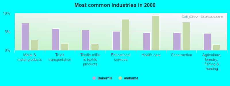
- Metal & metal products (7.4%)
- Truck transportation (5.9%)
- Textile mills & textile products (5.5%)
- Educational services (5.1%)
- Health care (4.8%)
- Construction (4.8%)
- Agriculture, forestry, fishing & hunting (4.6%)
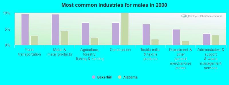
- Truck transportation (9.8%)
- Metal & metal products (9.6%)
- Agriculture, forestry, fishing & hunting (7.1%)
- Construction (7.1%)
- Textile mills & textile products (6.5%)
- Department & other general merchandise stores (4.9%)
- Administrative & support & waste management services (3.6%)
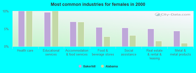
- Health care (10.0%)
- Educational services (9.7%)
- Accommodation & food services (7.0%)
- Food & beverage stores (5.5%)
- Social assistance (5.3%)
- Real estate & rental & leasing (5.0%)
- Metal & metal products (4.4%)
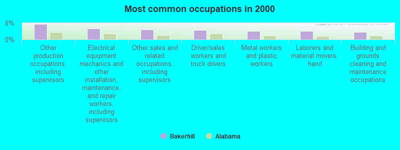
- Other production occupations, including supervisors (7.4%)
- Electrical equipment mechanics and other installation, maintenance, and repair workers, including supervisors (5.2%)
- Other sales and related occupations, including supervisors (4.8%)
- Driver/sales workers and truck drivers (4.7%)
- Metal workers and plastic workers (4.2%)
- Laborers and material movers, hand (4.0%)
- Building and grounds cleaning and maintenance occupations (3.5%)
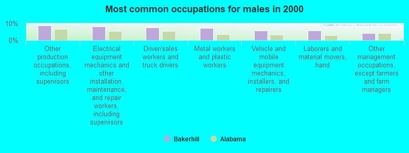
- Other production occupations, including supervisors (8.9%)
- Electrical equipment mechanics and other installation, maintenance, and repair workers, including supervisors (8.2%)
- Driver/sales workers and truck drivers (7.6%)
- Metal workers and plastic workers (7.3%)
- Vehicle and mobile equipment mechanics, installers, and repairers (5.8%)
- Laborers and material movers, hand (5.7%)
- Other management occupations, except farmers and farm managers (4.2%)
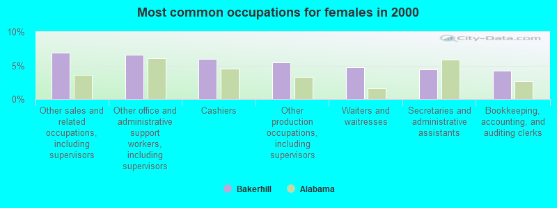
- Other sales and related occupations, including supervisors (6.9%)
- Other office and administrative support workers, including supervisors (6.6%)
- Cashiers (5.9%)
- Other production occupations, including supervisors (5.5%)
- Waiters and waitresses (4.7%)
- Secretaries and administrative assistants (4.4%)
- Bookkeeping, accounting, and auditing clerks (4.2%)
Average climate in Bakerhill, Alabama
Based on data reported by over 4,000 weather stations


Tornado activity:
Bakerhill-area historical tornado activity is slightly below Alabama state average. It is 47% greater than the overall U.S. average.
On 1/13/1972, a category F3 (max. wind speeds 158-206 mph) tornado 6.9 miles away from the Bakerhill place center injured 2 people and caused between $50,000 and $500,000 in damages.
On 11/25/1986, a category F3 tornado 14.7 miles away from the place center injured 4 people and caused between $500,000 and $5,000,000 in damages.
Earthquake activity:
Bakerhill-area historical earthquake activity is significantly above Alabama state average. It is 19% greater than the overall U.S. average.On 10/24/1997 at 08:35:17, a magnitude 4.9 (4.8 MB, 4.2 MS, 4.9 LG, Depth: 6.2 mi, Class: Light, Intensity: IV - V) earthquake occurred 128.4 miles away from Bakerhill center
On 1/18/1999 at 07:00:53, a magnitude 4.8 (4.8 MB, 4.0 LG, Depth: 0.6 mi) earthquake occurred 163.2 miles away from the city center
On 4/29/2003 at 08:59:39, a magnitude 4.9 (4.4 MB, 4.6 MW, 4.9 LG) earthquake occurred 189.6 miles away from the city center
On 8/2/1974 at 08:52:09, a magnitude 4.9 (4.3 MB, 4.9 LG) earthquake occurred 215.8 miles away from Bakerhill center
On 4/29/2003 at 08:59:39, a magnitude 4.6 (4.6 MW, Depth: 12.3 mi) earthquake occurred 189.6 miles away from the city center
On 6/24/1975 at 11:11:36, a magnitude 4.5 (4.5 MB) earthquake occurred 202.8 miles away from the city center
Magnitude types: regional Lg-wave magnitude (LG), body-wave magnitude (MB), surface-wave magnitude (MS), moment magnitude (MW)
Natural disasters:
The number of natural disasters in Barbour County (20) is greater than the US average (15).Major Disasters (Presidential) Declared: 13
Emergencies Declared: 5
Causes of natural disasters: Storms: 11, Floods: 8, Tornadoes: 7, Hurricanes: 6, Winds: 3, Drought: 1, Snowfall: 1, Tropical Storm: 1, Winter Storm: 1, Other: 1 (Note: some incidents may be assigned to more than one category).
Hospitals and medical centers near Bakerhill:
- WIREGRASS HOSPICE EUFAULA (Hospital, about 9 miles away; EUFAULA, AL)
- LAKEVIEW HOSPICE (Hospital, about 10 miles away; EUFAULA, AL)
- MEDICAL CENTER BARBOUR Acute Care Hospitals (about 10 miles away; EUFAULA, AL)
- CROWNE HEALTH CARE OF EUFAULA (Nursing Home, about 10 miles away; EUFAULA, AL)
- EUFAULA DIALYSIS (Dialysis Facility, about 10 miles away; EUFAULA, AL)
- BARBOUR COUNTY HOME CARE AGENCY (Home Health Center, about 15 miles away; CLAYTON, AL)
- CLAY COUNTY-FT GAINES HOSPITAL (Hospital, about 16 miles away; FORT GAINES, GA)
Colleges/universities with over 2000 students nearest to Bakerhill:
- George C Wallace State Community College-Dothan (about 35 miles; Dothan, AL; Full-time enrollment: 3,611)
- Troy University (about 43 miles; Troy, AL; FT enrollment: 16,148)
- Enterprise State Community College (about 49 miles; Enterprise, AL; FT enrollment: 2,101)
- Columbus Technical College (about 53 miles; Columbus, GA; FT enrollment: 3,241)
- Columbus State University (about 54 miles; Columbus, GA; FT enrollment: 6,876)
- Tuskegee University (about 54 miles; Tuskegee, AL; FT enrollment: 2,810)
- Auburn University (about 60 miles; Auburn University, AL; FT enrollment: 22,741)
Points of interest:
Notable location: Baker Hill Volunteer Fire Department (A). Display/hide its location on the map
| This place: | 2.5 people |
| Alabama: | 2.5 people |
| This place: | 73.3% |
| Whole state: | 67.8% |
| This place: | 4.9% |
| Whole state: | 4.7% |
Likely homosexual households (counted as self-reported same-sex unmarried-partner households)
- Lesbian couples: 0.7% of all households
- Gay men: 0.1% of all households
| This place: | 23.5% |
| Whole state: | 16.1% |
| This place: | 15.4% |
| Whole state: | 7.3% |
| Here: | 11.4 |
| Alabama average: | 13.2 |
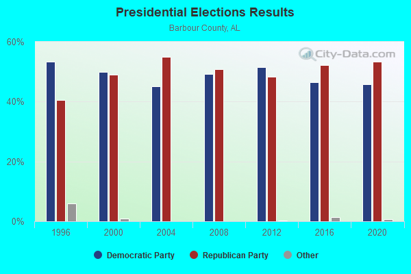
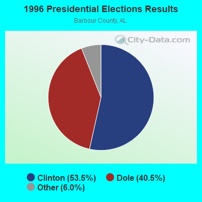
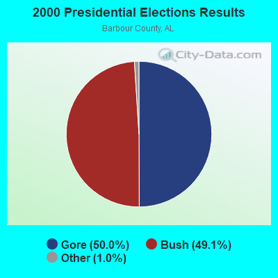
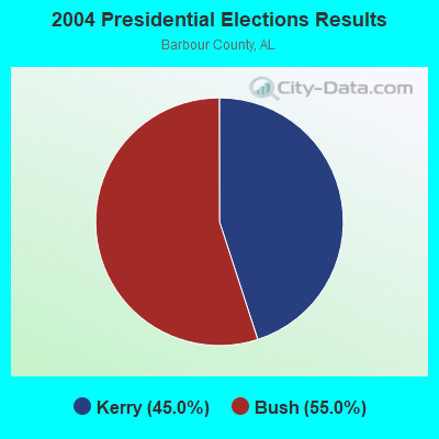
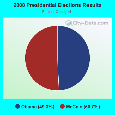
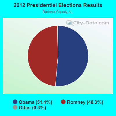
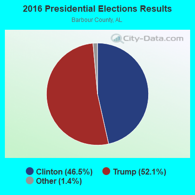
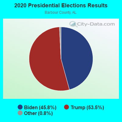
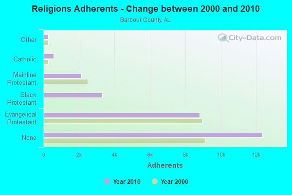
Graphs represent county-level data. Detailed 2008 Election Results
Religion statistics for Bakerhill, AL (based on Barbour County data)
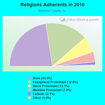
| Religion | Adherents | Congregations |
|---|---|---|
| Evangelical Protestant | 8,793 | 51 |
| Black Protestant | 3,328 | 21 |
| Mainline Protestant | 2,140 | 14 |
| Catholic | 575 | 1 |
| Other | 265 | 2 |
| None | 12,356 | - |
Food Environment Statistics:
| This county: | 2.04 / 10,000 pop. |
| Alabama: | 1.89 / 10,000 pop. |
| Barbour County: | 0.68 / 10,000 pop. |
| Alabama: | 0.65 / 10,000 pop. |
| Barbour County: | 6.45 / 10,000 pop. |
| Alabama: | 6.32 / 10,000 pop. |
| Here: | 3.73 / 10,000 pop. |
| State: | 5.75 / 10,000 pop. |
| Barbour County: | 13.0% |
| Alabama: | 11.8% |
| This county: | 36.4% |
| Alabama: | 31.7% |
| Barbour County: | 20.8% |
| State: | 13.5% |
| Local government employment and payroll (March 2022) | |||||
| Function | Full-time employees | Monthly full-time payroll | Average yearly full-time wage | Part-time employees | Monthly part-time payroll |
|---|---|---|---|---|---|
| Police Protection - Officers | 4 | $16,191 | $48,573 | 0 | $0 |
| Streets and Highways | 2 | $4,694 | $28,164 | 3 | $4,163 |
| Parks and Recreation | 0 | $0 | 3 | $2,188 | |
| Other Government Administration | 0 | $0 | 1 | $250 | |
| Totals for Government | 6 | $20,885 | $41,770 | 7 | $6,601 |
Strongest AM radio stations in Bakerhill:
- WQLS (1200 AM; 10 kW; OZARK, AL; Owner: STYLES BROADCASTING OF DOTHAN, INC.)
- WOOF (560 AM; 5 kW; DOTHAN, AL; Owner: WOOF, INC.)
- WULA (1240 AM; 1 kW; EUFAULA, AL; Owner: MARK HELLINGER)
- WDAK (540 AM; 5 kW; COLUMBUS, GA; Owner: CLEAR CHANNEL BROADCASTING LICENSES, INC.)
- WMAC (940 AM; 50 kW; MACON, GA; Owner: CUMULUS LICENSING CORP.)
- WGST (640 AM; 50 kW; ATLANTA, GA; Owner: CITICASTERS LICENSES, L.P.)
- WSTT (730 AM; 25 kW; THOMASVILLE, GA; Owner: MARION R. WILLIAMS)
- WJOX (690 AM; 50 kW; BIRMINGHAM, AL; Owner: CITADEL BROADCASTING COMPANY)
- WTBF (970 AM; 5 kW; TROY, AL; Owner: TROY BROADCASTING CORP.)
- WNSI (810 AM; 50 kW; JACKSONVILLE, AL; Owner: UNITED BROADCASTING NETWORK, INC.)
- WSB (750 AM; 50 kW; ATLANTA, GA; Owner: CXR HOLDINGS, INC.)
- WCNN (680 AM; 50 kW; NORTH ATLANTA, GA; Owner: DICKEY BROADCASTING COMPANY)
- WMSP (740 AM; 10 kW; MONTGOMERY, AL; Owner: CUMULUS LICENSING CORP.)
Strongest FM radio stations in Bakerhill:
- WIOL (92.7 FM; EUFAULA, AL; Owner: HATCHEE CREEK COMMUNICATIONS, INC.)
- W220BI (91.9 FM; EUFAULA, AL; Owner: MONTGOMERY CHRISTIAN EDUC., RADIO)
- WRVX (97.9 FM; EUFAULA, AL; Owner: RIVER VALLEY MEDIA, L.L.C.)
- WTVY-FM (95.5 FM; DOTHAN, AL; Owner: STYLES BROADCASTING OF DOTHAN, INC.)
- WQLD (104.3 FM; LUVERNE, AL; Owner: CAPSTAR TX LIMITED PARTNERSHIP)
- WZHT (105.7 FM; TROY, AL; Owner: CAPSTAR TX LIMITED PARTNERSHIP)
- WOOF-FM (99.7 FM; DOTHAN, AL; Owner: WOOF, INC.)
- WIZB (94.3 FM; ABBEVILLE, AL; Owner: CELEBRATIONS COMMUNICATIONS COMPANY, INC.)
- WJWV (90.9 FM; FORT GAINES, GA; Owner: GEORGIA PUBLIC TELECOMMUNICATIONS COMMISSION)
- WKCN (99.3 FM; LUMPKIN, GA; Owner: ABG GEORGIA, LLC)
TV broadcast stations around Bakerhill:
- WGIQ (Channel 43; LOUISVILLE, AL; Owner: ALABAMA EDUCATIONAL TELEVISION COMMISSION)
- W30BD (Channel 30; EUFAULA, AL; Owner: TRINITY BROADCASTING NETWORK)
- WTVM (Channel 9; COLUMBUS, GA; Owner: RAYCOM AMERICA, INC.)
- WRBL (Channel 3; COLUMBUS, GA; Owner: MEDIA GENERAL BROADCASTING OF SO. CAROLINA HOLDINGS, INC.)
- WRJM-TV (Channel 67; TROY, AL; Owner: JOSIE PARK BROADCASTING, INC.)
- WSFA (Channel 12; MONTGOMERY, AL; Owner: LIBCO, INC.)
- WCOV-TV (Channel 20; MONTGOMERY, AL; Owner: WOODS COMMUNICATIONS CORPORATION)
- WACS-TV (Channel 25; DAWSON, GA; Owner: GEORGIA PUBLIC TELECOMMUNICATIONS COMMISSION)
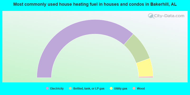
- 72.9%Electricity
- 16.3%Bottled, tank, or LP gas
- 10.1%Utility gas
- 0.7%Wood
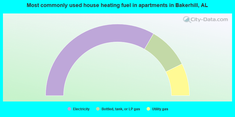
- 66.7%Electricity
- 18.7%Bottled, tank, or LP gas
- 14.6%Utility gas
Bakerhill compared to Alabama state average:
- Median house value below state average.
- Unemployed percentage significantly below state average.
- Hispanic race population percentage significantly below state average.
- Median age below state average.
- Foreign-born population percentage significantly below state average.
- Length of stay since moving in significantly above state average.
- Number of rooms per house significantly below state average.
- House age significantly below state average.
- Number of college students below state average.
- Percentage of population with a bachelor's degree or higher significantly below state average.
Bakerhill on our top lists:
- #24 on the list of "Top 101 cities with the largest percentage of mobile homes (2,000+ housing units)"