Benton-Collirene, Alabama
Submit your own pictures of this place and show them to the world
- OSM Map
- Google Map
- MSN Map
| Males: 971 | |
| Females: 1,197 |
| Median resident age: | 32.2 years |
| Alabama median age: | 35.8 years |
Zip code: 36785
| Benton-Collirene: | $26,336 |
| AL: | $59,674 |
Estimated per capita income in 2022: $18,982 (it was $9,969 in 2000)
Benton-Collirene CCD income, earnings, and wages data
Estimated median house or condo value in 2022: $83,995 (it was $42,000 in 2000)
| Benton-Collirene: | $83,995 |
| AL: | $200,900 |
Mean prices in 2022: all housing units: $163,152; detached houses: $225,649; mobile homes: $82,291
Benton-Collirene, AL residents, houses, and apartments details
Detailed information about poverty and poor residents in Benton-Collirene, AL
Compare current foreclosures near your location:
| Photo | Address | Area | Beds / Baths | Price | Details |
|---|---|---|---|---|---|

|
#1
Bayberry Cir
Columbus, OH 43207
|
1,564 sq. feet
|
1 baths 3 beds |
$127,500
|
show details |

|
#2
E 21st Ave
Columbus, OH 43211
|
1,061 sq. feet
|
1 baths 3 beds |
$187,900
|
show details |

|
#3
S High St
Columbus, OH 43207
|
1,678 sq. feet
|
2 baths 4 beds |
$31,900
|
show details |

|
#4
Mayflower Blvd
Columbus, OH 43213
|
1,591 sq. feet
|
2 baths 4 beds |
show details | |

|
#5
Mink St SW
Pataskala, OH 43062
|
1,442 sq. feet
|
1 baths 3 beds |
show details | |

|
#6
Bunch Flower Ct
Westerville, OH 43082
|
3,173 sq. feet
|
2 baths 4 beds |
show details | |

|
#7
Derrer Rd -872
Columbus, OH 43204
|
1,667 sq. feet
|
2 baths 5 beds |
show details | |

|
#8
N Roys Ave
Columbus, OH 43204
|
1,248 sq. feet
|
2 baths 3 beds |
show details | |

|
#9
S Richardson Ave
Columbus, OH 43204
|
1,520 sq. feet
|
2 baths 3 beds |
show details | |

|
#10
S Chillicothe St
Plain City, OH 43064
|
1,736 sq. feet
|
2 baths 4 beds |
show details |
| Photo | Address | Area | Beds / Baths | Price | Details |
|---|---|---|---|---|---|

|
#11
Bretton Pl
Columbus, OH 43211
|
1,056 sq. feet
|
1 baths 3 beds |
show details | |

|
#12
Trotter Dr
Columbus, OH 43207
|
1,478 sq. feet
|
1 baths 3 beds |
show details | |

|
#13
Ferris Rd
Columbus, OH 43224
|
2,218 sq. feet
|
3 baths 3 beds |
show details | |

|
#14
Meadowbrook Dr
Columbus, OH 43207
|
1,752 sq. feet
|
2 baths 4 beds |
show details | |

|
#15
Vineyard Haven Loop
Dublin, OH 43016
|
4,625 sq. feet
|
4 baths 4 beds |
show details | |

|
#16
Rosewood Ct
Powell, OH 43065
|
2,801 sq. feet
|
3 baths 4 beds |
show details | |

|
#17
High Free Pike
West Jefferson, OH 43162
|
1,216 sq. feet
|
2 baths 4 beds |
show details | |

|
#18
Striebel Ct
Columbus, OH 43227
|
925 sq. feet
|
1 baths 3 beds |
show details | |

|
#19
Elaine Rd
Columbus, OH 43213
|
764 sq. feet
|
1 baths 2 beds |
show details | |

|
#20
Falls Peak Ln
Delaware, OH 43015
|
1,352 sq. feet
|
2 baths 2 beds |
show details |
| Photo | Address | Area | Beds / Baths | Price | Details |
|---|---|---|---|---|---|

|
#21
S Hague Ave
Columbus, OH 43204
|
979 sq. feet
|
1 baths 2 beds |
show details | |

|
#22
Wrexham Ave
Columbus, OH 43223
|
1,235 sq. feet
|
1 baths 3 beds |
show details | |

|
#23
Kingsglen Dr
Grove City, OH 43123
|
1,635 sq. feet
|
2 baths 4 beds |
show details | |

|
#24
Midland Ave
Columbus, OH 43223
|
1,518 sq. feet
|
1 baths 2 beds |
show details | |

|
#25
Stoneybrook Blvd # 21a
Hilliard, OH 43026
|
1,231 sq. feet
|
2 baths 3 beds |
show details | |

|
#26
Fergus Rd
Grove City, OH 43123
|
3,312 sq. feet
|
2 baths 4 beds |
show details | |

|
#27
Edgeview Rd
Columbus, OH 43207
|
1,700 sq. feet
|
1 baths 4 beds |
show details | |

|
#28
Belle Oak Dr
Galloway, OH 43119
|
1,296 sq. feet
|
2 baths 3 beds |
show details | |

|
#29
Marshrun Dr
Grove City, OH 43123
|
2,036 sq. feet
|
2 baths 4 beds |
show details | |

|
#30
Brookstone Dr
Westerville, OH 43082
|
1,783 sq. feet
|
3 baths 3 beds |
show details |
| Photo | Address | Area | Beds / Baths | Price | Details |
|---|---|---|---|---|---|

|
#31
Scottwood Rd
Columbus, OH 43227
|
1,008 sq. feet
|
1 baths 3 beds |
show details | |

|
#32
Fahlander Dr N
Columbus, OH 43229
|
1,338 sq. feet
|
2 baths 3 beds |
show details | |

|
#33
Bernadette Rd
Columbus, OH 43204
|
1,168 sq. feet
|
1 baths 3 beds |
show details | |

|
#34
Sleeping Meadow Dr
New Albany, OH 43054
|
3,211 sq. feet
|
2 baths 4 beds |
show details | |

|
#35
Hiawatha Park Dr
Columbus, OH 43211
|
1,278 sq. feet
|
1 baths 4 beds |
show details | |

|
#36
N Grener Ave
Columbus, OH 43228
|
1,120 sq. feet
|
1 baths 3 beds |
show details | |

|
#37
Mango Ln
Hilliard, OH 43026
|
1,024 sq. feet
|
1 baths 2 beds |
show details | |

|
#38
Conway Dr
Columbus, OH 43227
|
1,232 sq. feet
|
1 baths 3 beds |
show details | |

|
#39
Lynn Cir
Grove City, OH 43123
|
936 sq. feet
|
1 baths 3 beds |
show details | |

|
#40
Leap Rd
Hilliard, OH 43026
|
1,352 sq. feet
|
1 baths 3 beds |
show details |
| Photo | Address | Area | Beds / Baths | Price | Details |
|---|---|---|---|---|---|

|
#41
Barthel Ave
Columbus, OH 43227
|
1,276 sq. feet
|
1 baths 3 beds |
show details | |

|
#42
Pendent Ln
Columbus, OH 43207
|
1,260 sq. feet
|
2 baths 3 beds |
show details | |

|
#43
E Kanawha Ave
Columbus, OH 43214
|
1,230 sq. feet
|
1 baths 3 beds |
show details | |

|
#44
Oreily Dr
Galloway, OH 43119
|
1,533 sq. feet
|
2 baths 3 beds |
show details | |

|
#45
Ridgebury Dr
Hilliard, OH 43026
|
832 sq. feet
|
1 baths 2 beds |
show details | |

|
#46
Windy Hill Ln
Galloway, OH 43119
|
1,350 sq. feet
|
2 baths 3 beds |
show details | |

|
#47
Windy Hill Ln
Galloway, OH 43119
|
1,108 sq. feet
|
2 baths 3 beds |
show details | |

|
#48
Tea Party Pl
Columbus, OH 43207
|
1,176 sq. feet
|
2 baths 3 beds |
show details | |

|
#49
Mango Ln
Hilliard, OH 43026
|
1,024 sq. feet
|
1 baths 2 beds |
show details | |

|
Check over 1 million property listings on Foreclosure.com!
|
browse all offers | |||

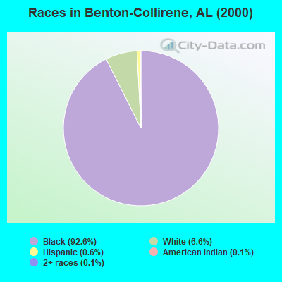
- 2,13792.6%Black alone
- 1526.6%White alone
- 140.6%Hispanic
- 30.1%American Indian alone
- 30.1%Two or more races
 Recent articles from our blog. Our writers, many of them Ph.D. graduates or candidates, create easy-to-read articles on a wide variety of topics.
Current Local Time: CST time zone
Land area: 113.4 square miles.
Population density: 19 people per square mile (very low).
| Benton-Collirene CCD: | 0.5% ($199) |
| Alabama: | 0.4% ($289) |
Nearest city with pop. 50,000+: Montgomery, AL  (30.9 miles , pop. 201,568).
Nearest city with pop. 1,000,000+: Houston, TX (537.4 miles , pop. 1,953,631).
Nearest cities:
), ), )Latitude: 32.24 N, Longitude: 86.79 W
Area code commonly used in this area: 334
| Here: | 5.3% |
| Alabama: | 2.6% |
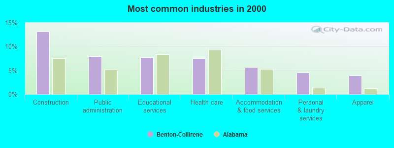
- Construction (13.1%)
- Public administration (8.0%)
- Educational services (7.7%)
- Health care (7.6%)
- Accommodation & food services (5.7%)
- Personal & laundry services (4.6%)
- Apparel (3.9%)
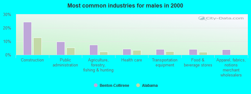
- Construction (24.4%)
- Public administration (9.7%)
- Agriculture, forestry, fishing & hunting (7.5%)
- Health care (4.4%)
- Transportation equipment (4.2%)
- Food & beverage stores (4.2%)
- Apparel, fabrics, notions merchant wholesalers (3.9%)
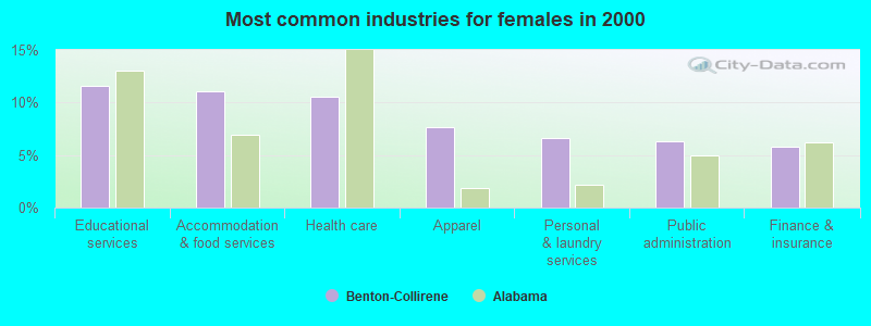
- Educational services (11.6%)
- Accommodation & food services (11.1%)
- Health care (10.6%)
- Apparel (7.7%)
- Personal & laundry services (6.6%)
- Public administration (6.3%)
- Finance & insurance (5.8%)
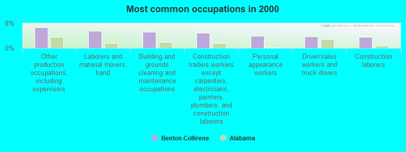
- Other production occupations, including supervisors (6.6%)
- Laborers and material movers, hand (5.5%)
- Building and grounds cleaning and maintenance occupations (5.3%)
- Construction traders workers except carpenters, electricians, painters, plumbers, and construction laborers (4.9%)
- Personal appearance workers (3.9%)
- Driver/sales workers and truck drivers (3.8%)
- Construction laborers (3.7%)
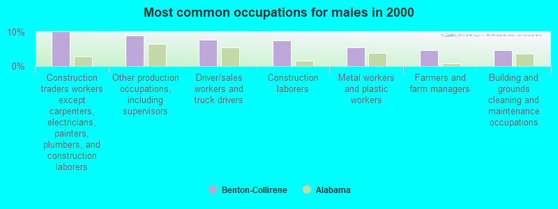
- Construction traders workers except carpenters, electricians, painters, plumbers, and construction laborers (10.0%)
- Other production occupations, including supervisors (8.9%)
- Driver/sales workers and truck drivers (7.8%)
- Construction laborers (7.5%)
- Metal workers and plastic workers (5.6%)
- Farmers and farm managers (4.7%)
- Building and grounds cleaning and maintenance occupations (4.7%)
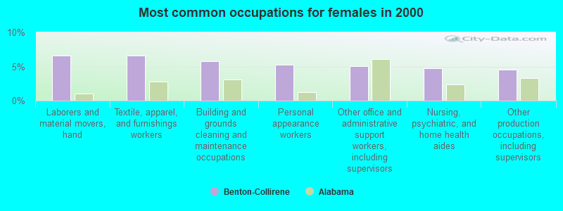
- Laborers and material movers, hand (6.6%)
- Textile, apparel, and furnishings workers (6.6%)
- Building and grounds cleaning and maintenance occupations (5.8%)
- Personal appearance workers (5.3%)
- Other office and administrative support workers, including supervisors (5.0%)
- Nursing, psychiatric, and home health aides (4.7%)
- Other production occupations, including supervisors (4.5%)
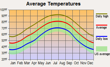
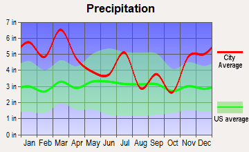
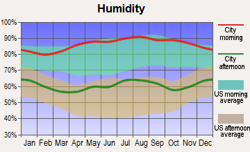
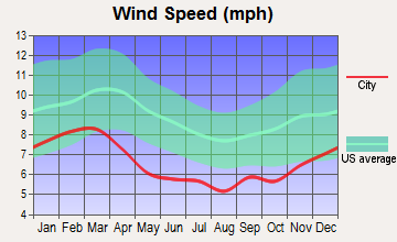
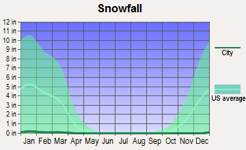
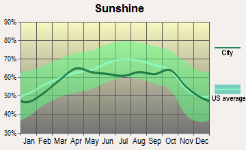
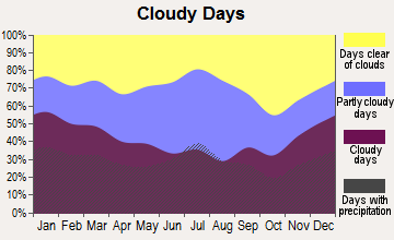
Average climate in Benton-Collirene, Alabama
Based on data reported by over 4,000 weather stations
Tornado activity:
Benton-Collirene-area historical tornado activity is below Alabama state average. It is 34% greater than the overall U.S. average.
On 4/18/1969, a category F4 (max. wind speeds 207-260 mph) tornado 29.8 miles away from the Benton-Collirene place center killed 2 people and injured 14 people and caused between $50,000 and $500,000 in damages.
On 4/23/1971, a category F4 tornado 34.8 miles away from the place center caused between $5000 and $50,000 in damages.
Earthquake activity:
Benton-Collirene-area historical earthquake activity is significantly above Alabama state average. It is 77% greater than the overall U.S. average.On 10/24/1997 at 08:35:17, a magnitude 4.9 (4.8 MB, 4.2 MS, 4.9 LG, Depth: 6.2 mi, Class: Light, Intensity: IV - V) earthquake occurred 82.3 miles away from the city center
On 1/18/1999 at 07:00:53, a magnitude 4.8 (4.8 MB, 4.0 LG, Depth: 0.6 mi) earthquake occurred 85.1 miles away from the city center
On 4/29/2003 at 08:59:39, a magnitude 4.9 (4.4 MB, 4.6 MW, 4.9 LG) earthquake occurred 169.7 miles away from Benton-Collirene center
On 11/7/2004 at 11:20:21, a magnitude 4.3 (4.3 MW, Depth: 3.1 mi) earthquake occurred 72.6 miles away from Benton-Collirene center
On 6/24/1975 at 11:11:36, a magnitude 4.5 (4.5 MB) earthquake occurred 119.2 miles away from Benton-Collirene center
On 4/29/2003 at 08:59:39, a magnitude 4.6 (4.6 MW, Depth: 12.3 mi) earthquake occurred 169.7 miles away from Benton-Collirene center
Magnitude types: regional Lg-wave magnitude (LG), body-wave magnitude (MB), surface-wave magnitude (MS), moment magnitude (MW)
Natural disasters:
The number of natural disasters in Lowndes County (13) is near the US average (15).Major Disasters (Presidential) Declared: 7
Emergencies Declared: 5
Causes of natural disasters: Hurricanes: 6, Storms: 4, Floods: 3, Tornadoes: 3, Winds: 2, Drought: 1, Snowfall: 1, Winter Storm: 1, Other: 1 (Note: some incidents may be assigned to more than one category).
Colleges/universities with over 2000 students nearest to Benton-Collirene:
- Alabama State University (about 31 miles; Montgomery, AL; Full-time enrollment: 5,457)
- Faulkner University (about 35 miles; Montgomery, AL; FT enrollment: 2,887)
- Auburn University at Montgomery (about 37 miles; Montgomery, AL; FT enrollment: 4,092)
- Troy University (about 58 miles; Troy, AL; FT enrollment: 16,148)
- University of Montevallo (about 61 miles; Montevallo, AL; FT enrollment: 2,826)
- Tuskegee University (about 65 miles; Tuskegee, AL; FT enrollment: 2,810)
- Shelton State Community College (about 76 miles; Tuscaloosa, AL; FT enrollment: 4,106)
Points of interest:
Notable location: Collirene Volunteer Fire Department (A). Display/hide its location on the map
Churches in Benton-Collirene include: Mount Nebo Church (A), New Bethel Church (B), Sanctified Church (C), Shiloh Baptist Church (D), Sellers Memorial Church (E), Saint Paul Church (F), Mount Sinai Church (G), Mount Lily Church (H), Macedonia Church (I). Display/hide their locations on the map
Cemeteries: Dunklin Cemetery (1), Robert Rives Cemetery (2), Rives Cemetery (3), Mount Gilead Cemetery (4), Good Hope Cemetery (5), Garr Cemetery (6), Bogahoma Cemetery (7). Display/hide their locations on the map
Reservoirs: Hollidays Pond (A), B C Rhyne Lake (B), Hoffman Rhyne Lake (C), Rice Lake (D), Bessie Beck Lake (E). Display/hide their locations on the map
Streams, rivers, and creeks: Panther Creek (A), Old Town Creek (B), Buck Creek (C), Church Branch (D), Big Swamp Creek (E). Display/hide their locations on the map
| This place: | 2.7 people |
| Alabama: | 2.5 people |
| This place: | 71.8% |
| Whole state: | 67.8% |
| This place: | 5.4% |
| Whole state: | 4.7% |
Likely homosexual households (counted as self-reported same-sex unmarried-partner households)
- Lesbian couples: 0.3% of all households
- Gay men: 0.1% of all households
| This place: | 29.3% |
| Whole state: | 16.1% |
| This place: | 12.9% |
| Whole state: | 7.3% |
For population 15 years and over in Benton-Collirene:
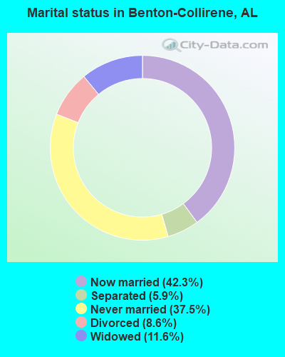
- Never married: 37.5%
- Now married: 42.3%
- Separated: 5.9%
- Widowed: 11.6%
- Divorced: 8.6%
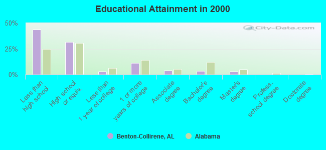
For population 25 years and over in Benton-Collirene:
- High school or higher: 56.3%
- Bachelor's degree or higher: 6.9%
- Graduate or professional degree: 3.4%
- Unemployed: 13.3%
- Mean travel time to work (commute): 40.9 minutes
| Here: | 16.7 |
| Alabama average: | 13.2 |
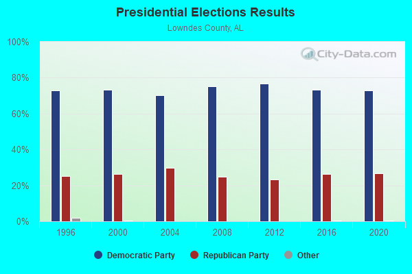
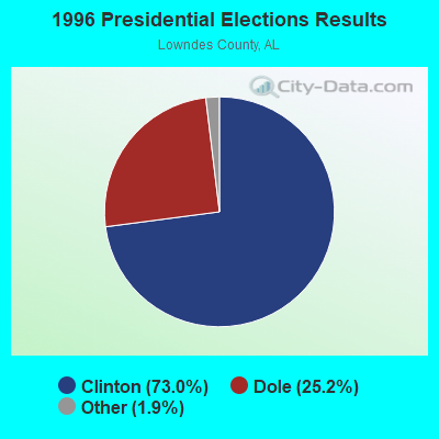
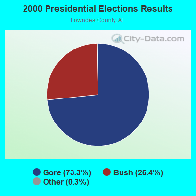
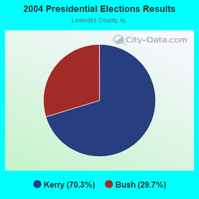
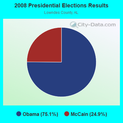
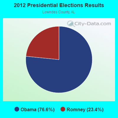
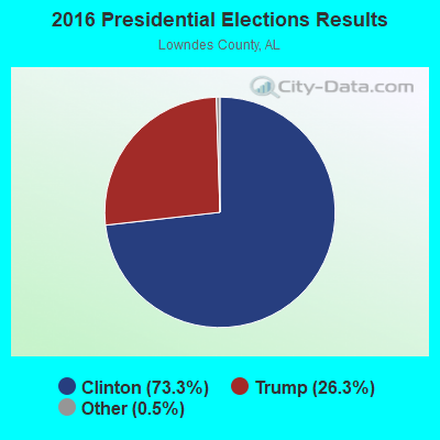
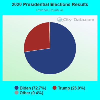
Graphs represent county-level data. Detailed 2008 Election Results
Religion statistics for Benton-Collirene, AL (based on Lowndes County data)
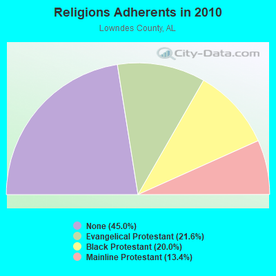
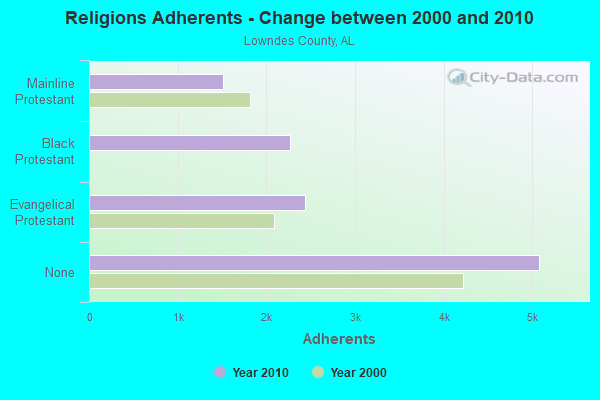
| Religion | Adherents | Congregations |
|---|---|---|
| Evangelical Protestant | 2,439 | 21 |
| Black Protestant | 2,265 | 12 |
| Mainline Protestant | 1,512 | 16 |
| Other | 1 | 1 |
| None | 5,082 | - |
Food Environment Statistics:
| This county: | 2.36 / 10,000 pop. |
| State: | 1.89 / 10,000 pop. |
| Here: | 0.79 / 10,000 pop. |
| Alabama: | 0.65 / 10,000 pop. |
| Lowndes County: | 7.87 / 10,000 pop. |
| Alabama: | 6.32 / 10,000 pop. |
| This county: | 0.79 / 10,000 pop. |
| State: | 5.75 / 10,000 pop. |
| This county: | 16.4% |
| Alabama: | 11.8% |
| Lowndes County: | 40.3% |
| Alabama: | 31.7% |
| Lowndes County: | 10.9% |
| Alabama: | 13.5% |
Strongest AM radio stations in Benton-Collirene:
- WJOX (690 AM; 50 kW; BIRMINGHAM, AL; Owner: CITADEL BROADCASTING COMPANY)
- WMSP (740 AM; 10 kW; MONTGOMERY, AL; Owner: CUMULUS LICENSING CORP.)
- WACV (1170 AM; 10 kW; MONTGOMERY, AL; Owner: MONTGOMERY BROADCAST PROPERTIES, LTD)
- WDJC (850 AM; 50 kW; BIRMINGHAM, AL; Owner: KIMTRON, INC.)
- WAPI (1070 AM; 50 kW; BIRMINGHAM, AL; Owner: CITADEL BROADCASTING COMPANY)
- WASG (550 AM; 25 kW; ATMORE, AL; Owner: 550 AM, INC)
- WLWI (1440 AM; 5 kW; MONTGOMERY, AL; Owner: CUMULUS LICENSING CORP.)
- WNSI (810 AM; 50 kW; JACKSONVILLE, AL; Owner: UNITED BROADCASTING NETWORK, INC.)
- WXVI (1600 AM; 5 kW; MONTGOMERY, AL; Owner: SUNSHINE 16 RADIO NETWORK, INC.)
- WAPZ (1250 AM; 5 kW; WETUMPKA, AL; Owner: J & W PROMOTIONS, INC.)
- WKNG (1060 AM; daytime; 50 kW; TALLAPOOSA, GA; Owner: WKNG, INC.)
- WGST (640 AM; 50 kW; ATLANTA, GA; Owner: CITICASTERS LICENSES, L.P.)
- WMRK (1340 AM; 1 kW; SELMA, AL; Owner: ALEXANDER B/C CO. INC.)
Strongest FM radio stations in Benton-Collirene:
- WAPR (88.3 FM; SELMA, AL; Owner: UA-ASU-TSU EDUCATIONAL RADIO CORP.)
- WLWI-FM (92.3 FM; MONTGOMERY, AL; Owner: CUMULUS LICENSING CORP.)
- WQLD (104.3 FM; LUVERNE, AL; Owner: CAPSTAR TX LIMITED PARTNERSHIP)
- WZHT (105.7 FM; TROY, AL; Owner: CAPSTAR TX LIMITED PARTNERSHIP)
- WALX (100.9 FM; SELMA, AL; Owner: ALEXANDER BROADCASTING COMPANY, INC.)
- WMXS (103.3 FM; MONTGOMERY, AL; Owner: CUMULUS LICENSING CORP.)
- WQKS-FM (96.1 FM; MONTGOMERY, AL; Owner: MONTGOMERY BROADCAST PROPERTIES, LTD)
- WBAM-FM (98.9 FM; MONTGOMERY, AL; Owner: DEEP SOUTH BROADCASTING COMPANY)
- WHHY-FM (101.9 FM; MONTGOMERY, AL; Owner: CUMULUS LICENSING CORP.)
- WMCZ (97.1 FM; MILLBROOK, AL; Owner: CAPSTAR TX LIMITED PARTNERSHIP)
- WKXN (95.9 FM; GREENVILLE, AL; Owner: AUTAUGAVILLE RADIO, INC.)
- WDXX (100.1 FM; SELMA, AL; Owner: BROADSOUTH COMMUNICATIONS, INC.)
- WVAS (90.7 FM; MONTGOMERY, AL; Owner: ALABAMA STATE UNIVERSITY (ASU))
- WJAM-FM (97.3 FM; ORRVILLE, AL; Owner: SCOTT COMMUNICATIONS, INC.)
- WAQU (91.1 FM; SELMA, AL; Owner: AMERICAN FAMILY ASSOCIATION)
- WXFX (95.1 FM; PRATTVILLE, AL; Owner: CUMULUS LICENSING CORP.)
- WBFZ (105.3 FM; SELMA, AL; Owner: IMANI COMMUNICATIONS CORPORATION, INC)
- WQZX (94.3 FM; GREENVILLE, AL; Owner: HAYNES BROADCASTING, INC.)
TV broadcast stations around Benton-Collirene:
- WAKA (Channel 8; SELMA, AL; Owner: ALABAMA BROADCASTING PARTNERS)
- W24CK (Channel 24; SELMA, AL; Owner: TRINITY BROADCASTING NETWORK)
- WBIH (Channel 29; SELMA, AL; Owner: FLINN BROADCASTING CORPORATION)
- WNCF (Channel 32; MONTGOMERY, AL; Owner: CHANNEL 32 MONTGOMERY LLC)
- WRJM-TV (Channel 67; TROY, AL; Owner: JOSIE PARK BROADCASTING, INC.)
- WSFA (Channel 12; MONTGOMERY, AL; Owner: LIBCO, INC.)
- WCOV-TV (Channel 20; MONTGOMERY, AL; Owner: WOODS COMMUNICATIONS CORPORATION)
- WMCF-TV (Channel 45; MONTGOMERY, AL; Owner: TRINITY BROADCASTING NETWORK)
- WETU-LP (Channel 39; WETUMPKA, AL; Owner: CABLE VIDEO PRODUCTIONS, INC.)
- WAIQ (Channel 26; MONTGOMERY, AL; Owner: ALABAMA EDUCATIONAL TELEVISION COMMISSION)
- National Bridge Inventory (NBI) Statistics
- 14Number of bridges
- 164ft / 50.0mTotal length
- $11,482,000Total costs
- 4,430Total average daily traffic
- 242Total average daily truck traffic
- 5,355Total future (year 2028) average daily traffic
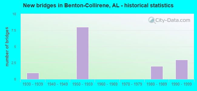
- New bridges - historical statistics
- 11930-1939
- 81950-1959
- 21980-1989
- 31990-1999
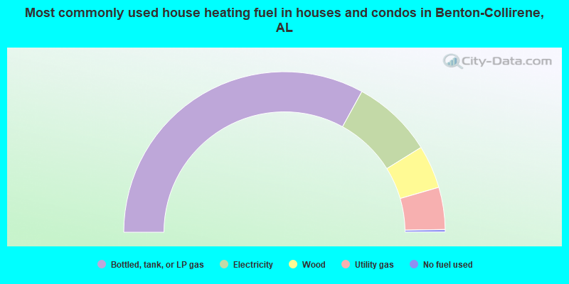
- 66.0%Bottled, tank, or LP gas
- 16.3%Electricity
- 8.7%Wood
- 8.5%Utility gas
- 0.5%No fuel used
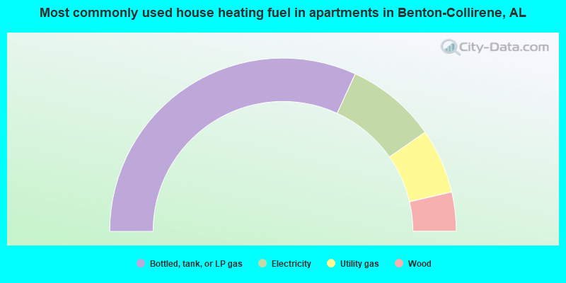
- 63.7%Bottled, tank, or LP gas
- 16.9%Electricity
- 12.1%Utility gas
- 7.3%Wood
Benton-Collirene compared to Alabama state average:
- Median household income significantly below state average.
- Median house value significantly below state average.
- Black race population percentage significantly above state average.
- Hispanic race population percentage significantly below state average.
- Median age significantly below state average.
- Foreign-born population percentage significantly below state average.
- Renting percentage below state average.
- Length of stay since moving in significantly above state average.
- Number of rooms per house significantly below state average.
- House age significantly below state average.
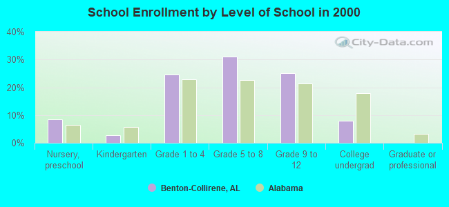
- Number of college students below state average.
- Percentage of population with a bachelor's degree or higher significantly below state average.