Bryant, Arkansas
Submit your own pictures of this city and show them to the world
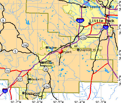
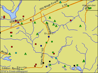
- OSM Map
- General Map
- Google Map
- MSN Map
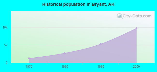
Population change since 2000: +120.2%
| Males: 9,708 | |
| Females: 11,793 |
| Median resident age: | 37.1 years |
| Arkansas median age: | 38.9 years |
Zip codes: 72022.
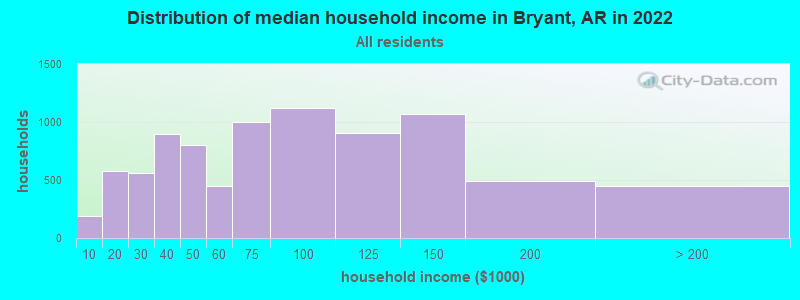
| Bryant: | $70,445 |
| AR: | $55,432 |
Estimated per capita income in 2022: $36,763 (it was $20,730 in 2000)
Bryant city income, earnings, and wages data
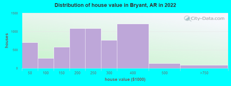
Estimated median house or condo value in 2022: $223,619 (it was $94,600 in 2000)
| Bryant: | $223,619 |
| AR: | $179,800 |
Mean prices in 2022: all housing units: $218,499; detached houses: $238,705; mobile homes: $48,269
Median gross rent in 2022: $867.
(8.4% for White Non-Hispanic residents, 4.6% for Black residents, 14.0% for Hispanic or Latino residents, 28.9% for American Indian residents, 2.1% for other race residents, 17.1% for two or more races residents)
Detailed information about poverty and poor residents in Bryant, AR


Compare current foreclosures in Bryant, AR:
| Photo | Address | Area | Beds / Baths | Price | Details |
|---|---|---|---|---|---|

|
#1
Holly Lynn Dr
Bryant, AR 72022
|
1,211 sq. feet
|
2 baths 3 beds |
show details | |

|
#2
Meadowlake Dr
Bryant, AR 72022
|
1,644 sq. feet
|
2 baths 3 beds |
show details | |

|
#3
Flametree Dr
Bryant, AR 72022
|
1,798 sq. feet
|
2 baths 3 beds |
show details | |

|
#4
Pleasant View Ct
Bryant, AR 72022
|
2,966 sq. feet
|
4 baths 4 beds |
show details | |

|
#5
A St
Bryant, AR 72022
|
1,929 sq. feet
|
2 baths 3 beds |
show details | |

|
#6
Debswood Dr
Bryant, AR 72022
|
2,124 sq. feet
|
3 baths - beds |
show details | |

|
#7
Bristol Dr
Bryant, AR 72022
|
1,352 sq. feet
|
1 baths - beds |
show details | |

|
#8
Justus Loop
Bryant, AR 72022
|
1,508 sq. feet
|
1 baths - beds |
show details | |

|
#9
Raymar Rd
Bryant, AR 72022
|
2,034 sq. feet
|
2 baths - beds |
show details | |

|
#10
Stivers Blvd
Bryant, AR 72022
|
1,320 sq. feet
|
1 baths - beds |
show details |
| Photo | Address | Area | Beds / Baths | Price | Details |
|---|---|---|---|---|---|

|
#11
Carmine Cv
Bryant, AR 72022
|
1,949 sq. feet
|
2 baths - beds |
show details | |

|
#12
Amy Cir
Bryant, AR 72022
|
1,571 sq. feet
|
2 baths - beds |
show details | |

|
#13
Brookside Dr
Bryant, AR 72022
|
1,818 sq. feet
|
2 baths - beds |
show details | |

|
#14
Cherry Creek Cir
Bryant, AR 72022
|
1,420 sq. feet
|
2 baths - beds |
show details | |

|
#15
Sanders Ln
Bryant, AR 72022
|
1,372 sq. feet
|
2 baths - beds |
show details | |

|
#16
Woodland Dr
Bryant, AR 72022
|
1,800 sq. feet
|
2 baths - beds |
show details | |

|
#17
Foxglove Dr
Bryant, AR 72022
|
1,508 sq. feet
|
2 baths - beds |
show details | |

|
#18
Lacie Ln
Bryant, AR 72022
|
2,157 sq. feet
|
2 baths - beds |
show details | |

|
#19
Hidden Creek Dr
Bryant, AR 72022
|
1,472 sq. feet
|
2 baths - beds |
show details | |

|
#20
Crestwood Cv
Bryant, AR 72022
|
2,937 sq. feet
|
2 baths - beds |
show details |
| Photo | Address | Area | Beds / Baths | Price | Details |
|---|---|---|---|---|---|

|
#21
Green Valley Dr
Bryant, AR 72022
|
2,026 sq. feet
|
2 baths - beds |
show details | |

|
#22
Commonwealth Dr
Bryant, AR 72022
|
2,578 sq. feet
|
2 baths - beds |
show details | |

|
#23
Miller Place Dr
Bryant, AR 72022
|
1,970 sq. feet
|
2 baths - beds |
show details | |

|
#24
Carywood Dr
Bryant, AR 72022
|
2,086 sq. feet
|
2 baths - beds |
show details | |

|
#25
Raintree Dr
Bryant, AR 72022
|
1,665 sq. feet
|
2 baths - beds |
show details | |

|
#26
SW 3rd St
Bryant, AR 72022
|
1,954 sq. feet
|
2 baths - beds |
show details | |

|
#27
Stivers Blvd
Bryant, AR 72022
|
1,586 sq. feet
|
2 baths - beds |
show details | |

|
#28
Longmeadow Dr
Bryant, AR 72022
|
1,635 sq. feet
|
2 baths - beds |
show details | |

|
#29
Andrew Dr
Bryant, AR 72022
|
1,640 sq. feet
|
2 baths - beds |
show details | |

|
#30
Pinnacle Dr
Bryant, AR 72022
|
1,648 sq. feet
|
2 baths - beds |
show details |
| Photo | Address | Area | Beds / Baths | Price | Details |
|---|---|---|---|---|---|

|
#31
Price Ave
Bryant, AR 72022
|
1,412 sq. feet
|
1 baths - beds |
show details | |

|
#32
Whirlwind St
Bryant, AR 72022
|
- sq. feet
|
- baths - beds |
show details | |

|
#33
Fieldstone Ln Apt E26
Bryant, AR 72022
|
- sq. feet
|
- baths - beds |
show details | |

|
#34
Indian Springs Dr
Bryant, AR 72022
|
- sq. feet
|
- baths - beds |
show details | |

|
#35
Garden Club Dr
Bryant, AR 72022
|
- sq. feet
|
- baths - beds |
show details | |

|
#36
Mimosa Ct
Bryant, AR 72022
|
- sq. feet
|
- baths - beds |
show details | |

|
#37
Carywood Dr
Bryant, AR 72022
|
- sq. feet
|
- baths - beds |
show details | |

|
#38
Finley Loop
Bryant, AR 72022
|
- sq. feet
|
- baths - beds |
show details | |

|
#39
Johnswood Rd
Bryant, AR 72022
|
- sq. feet
|
- baths - beds |
show details | |

|
#40
Masters Cv
Bryant, AR 72022
|
- sq. feet
|
- baths - beds |
show details |
| Photo | Address | Area | Beds / Baths | Price | Details |
|---|---|---|---|---|---|

|
#41
Lavern St Apt 4
Bryant, AR 72022
|
- sq. feet
|
- baths - beds |
show details | |

|
#42
Medinah Blvd
Bryant, AR 72022
|
- sq. feet
|
- baths - beds |
show details | |

|
#43
Garden Club Dr
Bryant, AR 72022
|
- sq. feet
|
- baths - beds |
show details | |

|
#44
Richland Park Dr
Bryant, AR 72022
|
- sq. feet
|
- baths - beds |
show details | |

|
#45
Dawsons Pointe Ave
Bryant, AR 72022
|
- sq. feet
|
- baths - beds |
show details | |

|
#46
Cyclone St
Bryant, AR 72022
|
- sq. feet
|
- baths - beds |
show details | |

|
#47
Merion Way # 706
Bryant, AR 72022
|
- sq. feet
|
- baths - beds |
show details | |

|
#48
Whirlwind St
Bryant, AR 72022
|
- sq. feet
|
- baths - beds |
show details | |

|
#49
Oak Hill Rd
Bryant, AR 72022
|
- sq. feet
|
- baths - beds |
show details | |

|
Check over 1 million property listings on Foreclosure.com!
|
browse all offers | |||


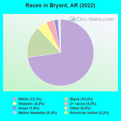
- 15,40872.3%White alone
- 3,28815.4%Black alone
- 1,0264.8%Hispanic
- 8574.0%Two or more races
- 3881.8%Asian alone
- 1230.6%Other race alone
- 820.4%Native Hawaiian and Other
Pacific Islander alone - 500.2%American Indian alone
According to our research of Arkansas and other state lists, there were 7 registered sex offenders living in Bryant, Arkansas as of April 27, 2024.
The ratio of all residents to sex offenders in Bryant is 2,808 to 1.
The ratio of registered sex offenders to all residents in this city is much lower than the state average.
Type |
2009 |
2010 |
2011 |
2012 |
2013 |
2014 |
2015 |
2016 |
2017 |
2018 |
2019 |
2020 |
2021 |
2022 |
|---|---|---|---|---|---|---|---|---|---|---|---|---|---|---|
| Murders (per 100,000) | 0 (0.0) | 0 (0.0) | 0 (0.0) | 0 (0.0) | 0 (0.0) | 0 (0.0) | 0 (0.0) | 0 (0.0) | 0 (0.0) | 0 (0.0) | 1 (4.7) | 0 (0.0) | 0 (0.0) | 2 (9.3) |
| Rapes (per 100,000) | 13 (83.5) | 4 (24.0) | 5 (29.7) | 5 (29.2) | 5 (25.8) | 0 (0.0) | 9 (44.1) | 4 (19.3) | 9 (43.7) | 2 (9.6) | 5 (23.6) | 9 (41.9) | 6 (27.4) | 3 (14.0) |
| Robberies (per 100,000) | 8 (51.4) | 5 (30.0) | 5 (29.7) | 11 (64.2) | 7 (36.1) | 0 (0.0) | 7 (34.3) | 6 (29.0) | 5 (24.3) | 2 (9.6) | 3 (14.1) | 4 (18.6) | 3 (13.7) | 5 (23.4) |
| Assaults (per 100,000) | 36 (231.2) | 0 (0.0) | 0 (0.0) | 0 (0.0) | 0 (0.0) | 0 (0.0) | 0 (0.0) | 19 (91.8) | 45 (218.5) | 28 (135.0) | 23 (108.4) | 26 (120.9) | 25 (114.1) | 16 (74.7) |
| Burglaries (per 100,000) | 179 (1,149) | 191 (1,145) | 207 (1,231) | 187 (1,092) | 204 (1,053) | 0 (0.0) | 230 (1,127) | 82 (396.4) | 57 (276.8) | 38 (183.2) | 45 (212.1) | 50 (232.6) | 50 (228.3) | 54 (252.3) |
| Thefts (per 100,000) | 552 (3,545) | 520 (3,116) | 658 (3,913) | 689 (4,022) | 668 (3,449) | 0 (0.0) | 610 (2,990) | 761 (3,679) | 871 (4,230) | 794 (3,829) | 783 (3,691) | 722 (3,359) | 643 (2,936) | 657 (3,069) |
| Auto thefts (per 100,000) | 27 (173.4) | 31 (185.8) | 46 (273.6) | 35 (204.3) | 33 (170.4) | 0 (0.0) | 35 (171.5) | 52 (251.4) | 64 (310.8) | 57 (274.9) | 60 (282.8) | 36 (167.5) | 59 (269.4) | 33 (154.2) |
| Arson (per 100,000) | 1 (6.4) | 1 (6.0) | 1 (5.9) | 0 (0.0) | 0 (0.0) | 0 (0.0) | 2 (9.8) | 0 (0.0) | 1 (4.9) | 0 (0.0) | 3 (14.1) | 0 (0.0) | 1 (4.6) | 4 (18.7) |
| City-Data.com crime index | 364.5 | 247.8 | 297.3 | 296.3 | 256.8 | 0.0 | 257.8 | 237.5 | 299.4 | 225.6 | 239.3 | 227.3 | 203.8 | 204.6 |
The City-Data.com crime index weighs serious crimes and violent crimes more heavily. Higher means more crime, U.S. average is 246.1. It adjusts for the number of visitors and daily workers commuting into cities.
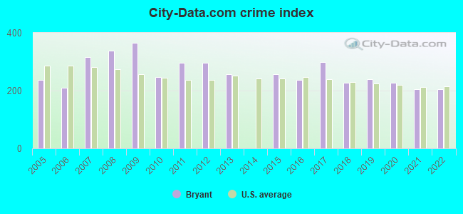
Crime rate in Bryant detailed stats: murders, rapes, robberies, assaults, burglaries, thefts, arson
Full-time law enforcement employees in 2021, including police officers: 58 (47 officers - 38 male; 9 female).
| Officers per 1,000 residents here: | 2.15 |
| Arkansas average: | 2.25 |
 Recent articles from our blog. Our writers, many of them Ph.D. graduates or candidates, create easy-to-read articles on a wide variety of topics.

 | Benton vs Bryant vs Conway - Where To Live? (26 replies) |
| Ranking of LR-Conway-NLR Suburbs (11 replies) |
| Yay or nay (move to little rock??) (56 replies) |
| Very interested in learning more about Benton, AR and vicinity (19 replies) |
| Bad Areas in Little Rock (14 replies) |
| Metroplan Population Estimates for 2020 (LR-NLR-Conway MSA) (0 replies) |
Latest news from Bryant, AR collected exclusively by city-data.com from local newspapers, TV, and radio stations
Ancestries: American (16.8%), Irish (8.6%), German (8.4%), English (7.9%), African (2.9%), European (2.3%).
Current Local Time: CST time zone
Elevation: 412 feet
Land area: 9.07 square miles.
Population density: 2,370 people per square mile (low).
554 residents are foreign born (1.4% Asia, 0.9% Latin America).
| This city: | 2.6% |
| Arkansas: | 5.0% |
Median real estate property taxes paid for housing units with mortgages in 2022: $1,623 (0.6%)
Median real estate property taxes paid for housing units with no mortgage in 2022: $1,132 (0.7%)
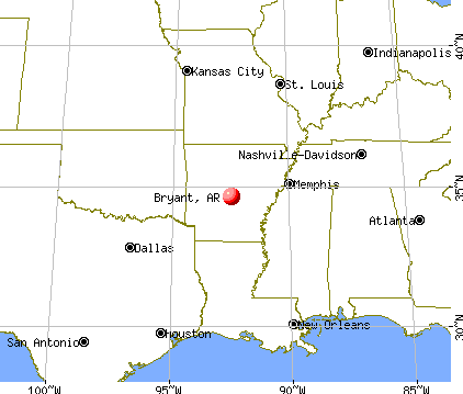
Nearest city with pop. 50,000+: Little Rock, AR  (12.4 miles , pop. 183,133).
Nearest city with pop. 200,000+: Memphis, TN (147.2 miles , pop. 650,100).
Nearest city with pop. 1,000,000+: Dallas, TX (277.2 miles , pop. 1,188,580).
Nearest cities:
), ), ), ), Latitude: 34.61 N, Longitude: 92.49 W
Daytime population change due to commuting: +4 (+0.0%)
Workers who live and work in this city: 3,207 (30.5%)
Area code commonly used in this area: 501
Bryant, Arkansas accommodation & food services, waste management - Economy and Business Data
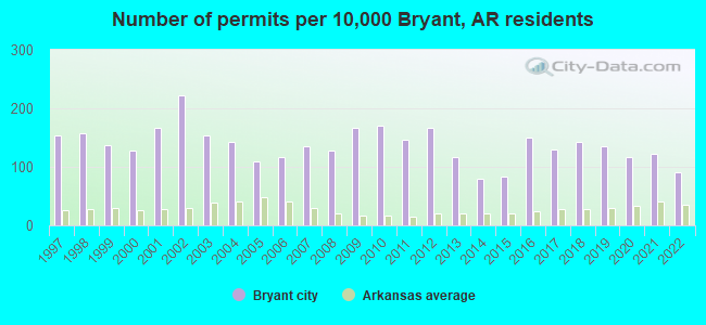
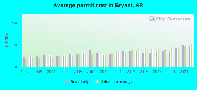
Single-family new house construction building permits:
- 2022: 88 buildings, average cost: $241,900
- 2021: 119 buildings, average cost: $246,800
- 2020: 113 buildings, average cost: $215,200
- 2019: 132 buildings, average cost: $187,200
- 2018: 140 buildings, average cost: $181,200
- 2017: 127 buildings, average cost: $184,700
- 2016: 146 buildings, average cost: $165,300
- 2015: 81 buildings, average cost: $159,400
- 2014: 78 buildings, average cost: $182,500
- 2013: 114 buildings, average cost: $180,900
- 2012: 162 buildings, average cost: $182,800
- 2011: 144 buildings, average cost: $172,600
- 2010: 167 buildings, average cost: $148,700
- 2009: 163 buildings, average cost: $141,600
- 2008: 124 buildings, average cost: $161,200
- 2007: 132 buildings, average cost: $194,500
- 2006: 114 buildings, average cost: $177,000
- 2005: 107 buildings, average cost: $149,400
- 2004: 139 buildings, average cost: $145,600
- 2003: 149 buildings, average cost: $141,700
- 2002: 217 buildings, average cost: $121,600
- 2001: 162 buildings, average cost: $131,400
- 2000: 124 buildings, average cost: $134,300
- 1999: 134 buildings, average cost: $120,800
- 1998: 154 buildings, average cost: $122,900
- 1997: 150 buildings, average cost: $113,000
| Here: | 2.8% |
| Arkansas: | 3.4% |
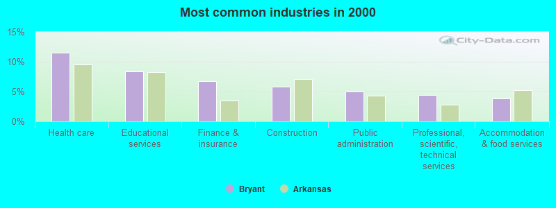
- Health care (11.5%)
- Educational services (8.4%)
- Finance & insurance (6.8%)
- Construction (5.8%)
- Public administration (5.0%)
- Professional, scientific, technical services (4.4%)
- Accommodation & food services (3.8%)
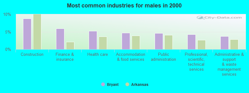
- Construction (8.8%)
- Finance & insurance (5.9%)
- Health care (5.2%)
- Accommodation & food services (4.7%)
- Public administration (4.6%)
- Professional, scientific, technical services (4.3%)
- Administrative & support & waste management services (3.8%)
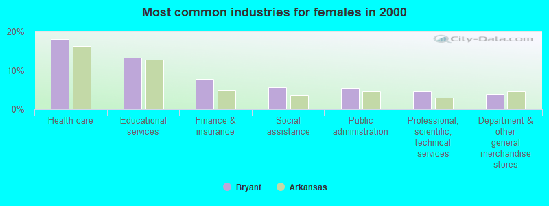
- Health care (18.0%)
- Educational services (13.2%)
- Finance & insurance (7.7%)
- Social assistance (5.6%)
- Public administration (5.5%)
- Professional, scientific, technical services (4.6%)
- Department & other general merchandise stores (3.9%)
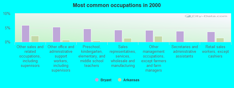
- Other sales and related occupations, including supervisors (5.9%)
- Other office and administrative support workers, including supervisors (5.3%)
- Preschool, kindergarten, elementary, and middle school teachers (4.6%)
- Sales representatives, services, wholesale and manufacturing (4.2%)
- Other management occupations, except farmers and farm managers (4.1%)
- Secretaries and administrative assistants (3.8%)
- Retail sales workers, except cashiers (3.6%)
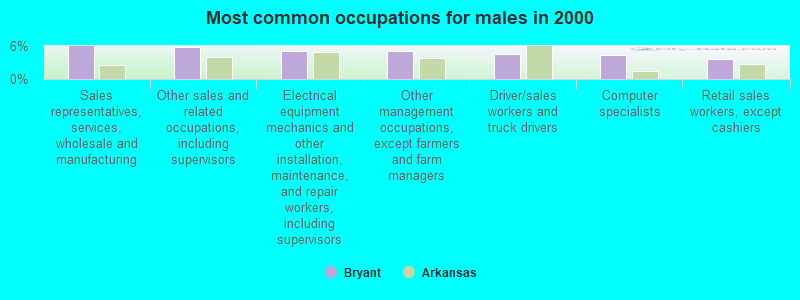
- Sales representatives, services, wholesale and manufacturing (6.0%)
- Other sales and related occupations, including supervisors (5.7%)
- Electrical equipment mechanics and other installation, maintenance, and repair workers, including supervisors (5.1%)
- Other management occupations, except farmers and farm managers (5.1%)
- Driver/sales workers and truck drivers (4.5%)
- Computer specialists (4.3%)
- Retail sales workers, except cashiers (3.6%)

- Preschool, kindergarten, elementary, and middle school teachers (8.1%)
- Other office and administrative support workers, including supervisors (8.1%)
- Secretaries and administrative assistants (7.7%)
- Other sales and related occupations, including supervisors (6.0%)
- Registered nurses (5.7%)
- Information and record clerks, except customer service representatives (4.7%)
- Retail sales workers, except cashiers (3.6%)
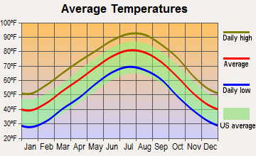
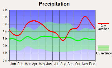
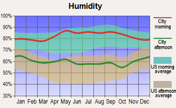
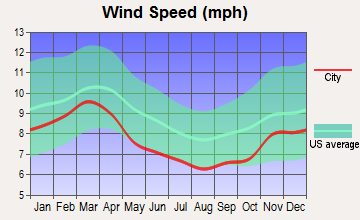
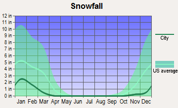
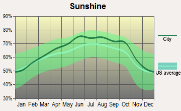
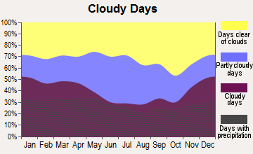
Average climate in Bryant, Arkansas
Based on data reported by over 4,000 weather stations
|
|

(lower is better)
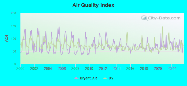
Air Quality Index (AQI) level in 2023 was 72.9. This is about average.
| City: | 72.9 |
| U.S.: | 72.6 |
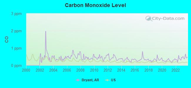
Carbon Monoxide (CO) [ppm] level in 2023 was 0.481. This is significantly worse than average. Closest monitor was 9.8 miles away from the city center.
| City: | 0.481 |
| U.S.: | 0.251 |
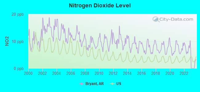
Nitrogen Dioxide (NO2) [ppb] level in 2022 was 7.45. This is significantly worse than average. Closest monitor was 9.8 miles away from the city center.
| City: | 7.45 |
| U.S.: | 5.11 |
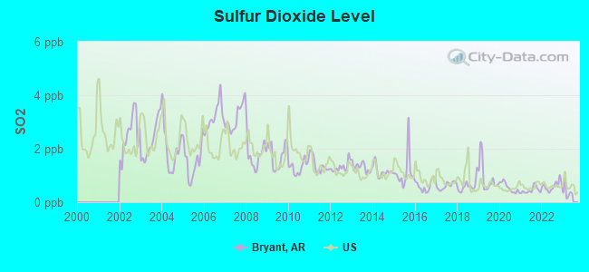
Sulfur Dioxide (SO2) [ppb] level in 2022 was 0.603. This is significantly better than average. Closest monitor was 9.8 miles away from the city center.
| City: | 0.603 |
| U.S.: | 1.515 |
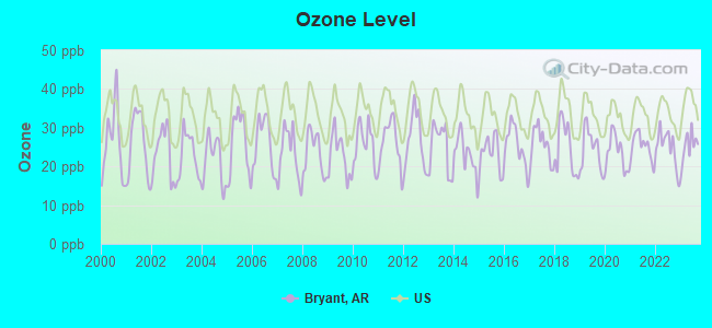
Ozone [ppb] level in 2023 was 25.2. This is better than average. Closest monitor was 9.8 miles away from the city center.
| City: | 25.2 |
| U.S.: | 33.3 |
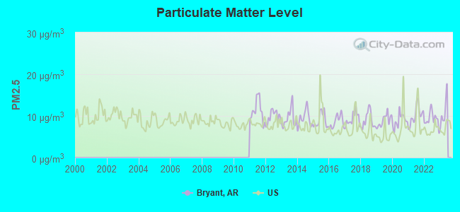
Particulate Matter (PM2.5) [µg/m3] level in 2022 was 9.25. This is about average. Closest monitor was 9.8 miles away from the city center.
| City: | 9.25 |
| U.S.: | 8.11 |
Tornado activity:
Bryant-area historical tornado activity is slightly above Arkansas state average. It is 141% greater than the overall U.S. average.
On 3/1/1997, a category F4 (max. wind speeds 207-260 mph) tornado 6.7 miles away from the Bryant city center killed 10 people and injured 40 people.
On 3/1/1997, a category F4 tornado 8.1 miles away from the city center killed 5 people and injured 180 people.
Earthquake activity:
Bryant-area historical earthquake activity is significantly above Arkansas state average. It is 478% greater than the overall U.S. average.On 11/6/2011 at 03:53:10, a magnitude 5.7 (5.7 MW, Depth: 3.2 mi, Class: Moderate, Intensity: VI - VII) earthquake occurred 250.1 miles away from the city center
On 1/21/1982 at 00:33:54, a magnitude 4.7 (4.5 MB, 4.7 LG, 4.5 LG, Class: Light, Intensity: IV - V) earthquake occurred 41.7 miles away from Bryant center
On 5/4/2001 at 06:42:12, a magnitude 4.7 (4.2 MB, 4.7 LG, 4.5 LG) earthquake occurred 44.3 miles away from Bryant center
On 2/28/2011 at 05:00:50, a magnitude 4.7 (4.7 MW, Depth: 2.0 mi) earthquake occurred 46.0 miles away from Bryant center
On 9/3/2016 at 12:02:44, a magnitude 5.8 (5.8 MW, Depth: 3.5 mi) earthquake occurred 279.4 miles away from Bryant center
On 3/25/1976 at 00:41:20, a magnitude 5.0 (4.9 MB, 5.0 LG) earthquake occurred 141.4 miles away from Bryant center
Magnitude types: regional Lg-wave magnitude (LG), body-wave magnitude (MB), moment magnitude (MW)
Natural disasters:
The number of natural disasters in Saline County (17) is near the US average (15).Major Disasters (Presidential) Declared: 12
Emergencies Declared: 3
Causes of natural disasters: Storms: 11, Floods: 9, Tornadoes: 8, Winter Storms: 4, Hurricanes: 2, Winds: 2, Other: 1 (Note: some incidents may be assigned to more than one category).
Hospitals and medical centers in Bryant:
Other hospitals and medical centers near Bryant:
- RIVENDELL BEHAVIORAL HEALTH SERVICES OF ARKANSAS (Hospital, about 3 miles away; BENTON, AR)
- RIDGEWOOD HEALTH AND REHAB (Nursing Home, about 4 miles away; BENTON, AR)
- STONEYBROOK HEALTH AND REHABILITATION CENTER (Nursing Home, about 4 miles away; BENTON, AR)
- FMCNA - BENTON (Dialysis Facility, about 6 miles away; BENTON, AR)
- SALINE COUNTY HEALTH UNIT (Home Health Center, about 6 miles away; BENTON, AR)
- HH SVCS OF SALINE MEMORIAL (Home Health Center, about 7 miles away; BENTON, AR)
- HH AND HOSPICE SRVC OF SALINE (Hospital, about 7 miles away; BENTON, AR)
Colleges/universities with over 2000 students nearest to Bryant:
- University of Arkansas at Little Rock (about 12 miles; Little Rock, AR; Full-time enrollment: 9,227)
- Pulaski Technical College (about 16 miles; North Little Rock, AR; FT enrollment: 8,396)
- University of Central Arkansas (about 33 miles; Conway, AR; FT enrollment: 9,972)
- National Park Community College (about 37 miles; Hot Springs, AR; FT enrollment: 2,237)
- University of Arkansas at Pine Bluff (about 38 miles; Pine Bluff, AR; FT enrollment: 2,558)
- Arkansas State University-Beebe (about 47 miles; Beebe, AR; FT enrollment: 3,387)
- Henderson State University (about 47 miles; Arkadelphia, AR; FT enrollment: 3,528)
Public high school in Bryant:
- BRYANT HIGH SCHOOL (Location: 201 SULLIVAN DR, Grades: 9-12)
Public elementary/middle schools in Bryant:
- BRYANT ELEMENTARY SCHOOL (Location: 200 NW FOURTH ST, Grades: KG-5)
- COLLEGEVILLE ELEMENTARY SCHOOL (Location: 4818 HWY 5 N, Grades: KG-5)
- BRYANT MIDDLE SCHOOL (Location: 412 WOODLAND DR, Grades: 6-8)
- HILL FARM ELEMENTARY SCHOOL (Location: 500 HILL FARM RD, Grades: KG-5)
Private elementary/middle school in Bryant:
Points of interest:
Notable locations in Bryant: Bryant Police Department (A), Bryant Fire Department Station 1 (B), Bryant Fire Department Station 2 (C), Bryant Fire and Rescue Station 3 (D), Bryant Branch Saline County Public Library (E), Bryant City Hall (F). Display/hide their locations on the map
Churches in Bryant include: Hurricane Lake Church (A), Abundant Life Center Assembly of God Church (B), Bryant Church of Christ (C), First Baptist Church (D), First Southern Baptist Church (E), First United Methodist Church (F), Grace Missionary Baptist Church (G), Indian Springs Baptist Church (H). Display/hide their locations on the map
Cemetery: Bryant Cemetery (1). Display/hide its location on the map
Reservoirs: Indian Springs Lake (A), Caldwell Lake (B). Display/hide their locations on the map
Parks in Bryant include: Ashley Park (1), Wilbur Mills Park (2), Bryant Stadium (3). Display/hide their locations on the map
Tourist attractions: Logan's Run (Amusement & Theme Parks; 5920 Highway 5 N Suite 3b), A T V & Water Sports (Tours & Charters; 23201 Interstate 30).
Hotels: Best Value Inn & Suites (407 West Commerce Street), Super 8 Bryant Little Rock Are (201 Dell Drive), Super 8 Motel (201 Dell Drive), Comfort Inn & Suites (209 West Commerce).
Court: Bryant Municipal Court (210 Southwest 3rd Street).
Birthplace of: Travis Wood - Baseball player, Jack McAdams - Baseball player.
Drinking water stations with addresses in Bryant and their reported violations in the past:
BRYANT WATERWORKS (Population served: 14,635, Purch surface water):Past health violations:Past monitoring violations:
- MCL, Monthly (TCR) - In JUL-2010, Contaminant: Coliform. Follow-up actions: St Public Notif requested (SEP-03-2010), St Compliance achieved (3 times from OCT-18-2010 to AUG-29-2011)
- MCL, Average - Between JAN-2008 and MAR-2008, Contaminant: TTHM. Follow-up actions: St Public Notif requested (MAY-05-2008), St Compliance achieved (MAR-12-2009)
- MCL, Monthly (TCR) - In JUN-2007, Contaminant: Coliform. Follow-up actions: St Public Notif requested (AUG-10-2007)
- 2 minor monitoring violations
| This city: | 2.5 people |
| Arkansas: | 2.5 people |
| This city: | 68.9% |
| Whole state: | 67.6% |
| This city: | 4.2% |
| Whole state: | 5.7% |
Likely homosexual households (counted as self-reported same-sex unmarried-partner households)
- Lesbian couples: 0.2% of all households
- Gay men: 0.2% of all households
People in group quarters in Bryant in 2010:
- 99 people in nursing facilities/skilled-nursing facilities
- 93 people in correctional facilities intended for juveniles
- 10 people in residential treatment centers for adults
18 people in homes for the mentally retarded in 2000
Banks with most branches in Bryant (2011 data):
- First Security Bank: Bryant Branch, Bryant Branch, The Union Bank Of Bryant Branch. Info updated 2009/06/12: Bank assets: $4,011.4 mil, Deposits: $3,167.1 mil, headquarters in Searcy, AR, positive income, Commercial Lending Specialization, 73 total offices, Holding Company: First Security Bancorp
- Heartland Bank: at 4937 Highway 5 North, branch established on 1933/01/01. Info updated 2011/11/28: Bank assets: $186.0 mil, Deposits: $145.3 mil, local headquarters, positive income, Commercial Lending Specialization, 4 total offices, Holding Company: Rock Bancshares, Inc.
- Summit Bank: Bryant Branch at 6110 Highway 5 North, branch established on 2008/08/11. Info updated 2011/02/25: Bank assets: $1,129.7 mil, Deposits: $946.3 mil, headquarters in Arkadelphia, AR, positive income, Commercial Lending Specialization, 25 total offices, Holding Company: Summit Bancorp, Inc.
- Arvest Bank: Bryant Branch at 3217 North Reynolds Road, branch established on 2001/10/08. Info updated 2010/11/29: Bank assets: $12,520.8 mil, Deposits: $10,446.2 mil, headquarters in Fayetteville, AR, positive income, Commercial Lending Specialization, 241 total offices, Holding Company: Arvest Bank Group, Inc.
- The Malvern National Bank: Bryant Branch at 4430 Highway 5 North, branch established on 1999/08/23. Info updated 2006/11/03: Bank assets: $470.8 mil, Deposits: $383.0 mil, headquarters in Malvern, AR, positive income, Commercial Lending Specialization, 12 total offices, Holding Company: Mnb Bancshares, Inc.
- Bank of the Ozarks: Bryant Highway 5 Branch at 5910 Highway 5 North, branch established on 2003/04/28. Info updated 2011/05/03: Bank assets: $3,828.0 mil, Deposits: $2,955.2 mil, headquarters in Little Rock, AR, positive income, Commercial Lending Specialization, 115 total offices, Holding Company: Bank Of The Ozarks Inc
- Iberiabank: Bryant Branch at 5111 Highway 5 North, branch established on 2003/07/07. Info updated 2011/06/08: Bank assets: $11,676.7 mil, Deposits: $9,387.9 mil, headquarters in Lafayette, LA, positive income, Commercial Lending Specialization, 187 total offices, Holding Company: Iberiabank Corporation
- Merchants and Farmers Bank: Merchants And Farmers Bryant Loan Pr at 4500 Highway 5 North, Suite 6, branch established on 2011/09/06. Info updated 2006/11/03: Bank assets: $95.6 mil, Deposits: $86.3 mil, headquarters in Dumas, AR, positive income, Agricultural Specialization, 3 total offices, Holding Company: M & F Financial Corporation
- Centennial Bank: Bryant Branch at 2224 N. Reynolds Rd., branch established on 2007/09/30. Info updated 2012/02/29: Bank assets: $3,588.2 mil, Deposits: $2,891.9 mil, headquarters in Conway, AR, positive income, Commercial Lending Specialization, 109 total offices, Holding Company: Home Bancshares, Inc.
- 3 other banks with 3 local branches
For population 15 years and over in Bryant:
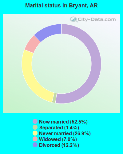
- Never married: 26.9%
- Now married: 52.5%
- Separated: 1.4%
- Widowed: 7.0%
- Divorced: 12.2%
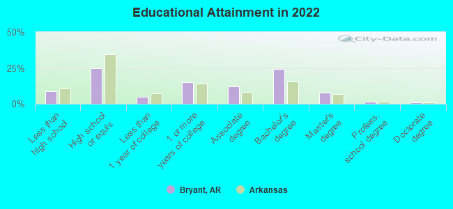
For population 25 years and over in Bryant:
- High school or higher: 92.8%
- Bachelor's degree or higher: 36.2%
- Graduate or professional degree: 10.3%
- Unemployed: 2.3%
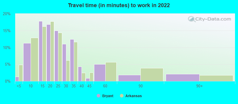
- Mean travel time to work (commute): 22.4 minutes
| Here: | 10.8 |
| Arkansas average: | 11.4 |

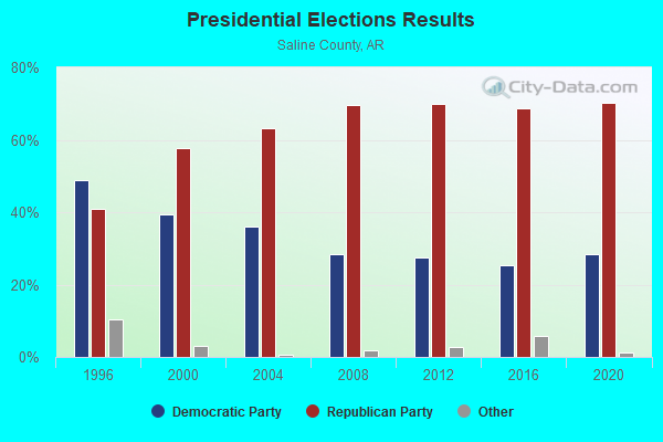
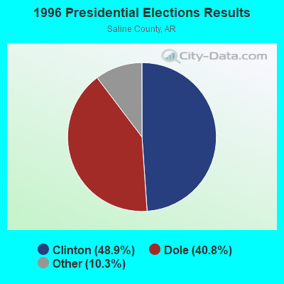
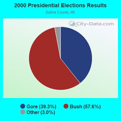
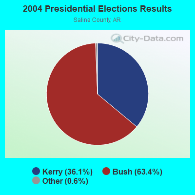


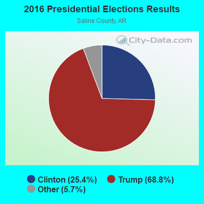
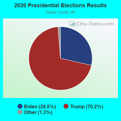
Graphs represent county-level data. Detailed 2008 Election Results
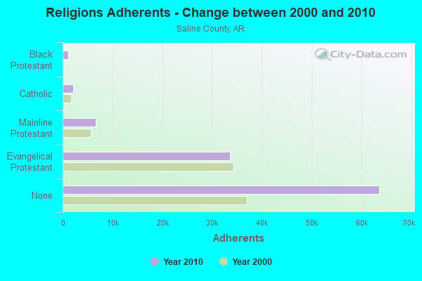
Religion statistics for Bryant, AR (based on Saline County data)
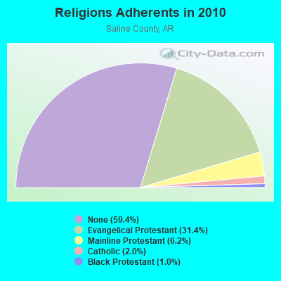
| Religion | Adherents | Congregations |
|---|---|---|
| Evangelical Protestant | 33,609 | 121 |
| Mainline Protestant | 6,680 | 17 |
| Catholic | 2,113 | 1 |
| Black Protestant | 1,081 | 6 |
| Other | 3 | 1 |
| None | 63,632 | - |
Food Environment Statistics:
| This county: | 1.46 / 10,000 pop. |
| State: | 2.02 / 10,000 pop. |
| Saline County: | 0.21 / 10,000 pop. |
| Arkansas: | 0.25 / 10,000 pop. |
| Here: | 0.21 / 10,000 pop. |
| State: | 0.59 / 10,000 pop. |
| Saline County: | 3.96 / 10,000 pop. |
| State: | 4.94 / 10,000 pop. |
| Saline County: | 4.89 / 10,000 pop. |
| Arkansas: | 6.66 / 10,000 pop. |
| This county: | 9.0% |
| State: | 9.8% |
| Here: | 27.0% |
| State: | 29.1% |
| This county: | 13.7% |
| State: | 13.6% |
Health and Nutrition:
| Bryant: | 49.6% |
| Arkansas: | 48.2% |
| Here: | 46.4% |
| Arkansas: | 44.2% |
| Here: | 28.9 |
| Arkansas: | 28.9 |
| Bryant: | 21.9% |
| Arkansas: | 21.6% |
| Here: | 10.8% |
| Arkansas: | 11.3% |
| Bryant: | 6.8 |
| State: | 6.8 |
| This city: | 34.4% |
| Arkansas: | 34.0% |
| Bryant: | 56.7% |
| State: | 54.4% |
| Bryant: | 78.8% |
| State: | 78.0% |
More about Health and Nutrition of Bryant, AR Residents
| Local government employment and payroll (March 2022) | |||||
| Function | Full-time employees | Monthly full-time payroll | Average yearly full-time wage | Part-time employees | Monthly part-time payroll |
|---|---|---|---|---|---|
| Firefighters | 49 | $265,838 | $65,103 | 0 | $0 |
| Police Protection - Officers | 49 | $294,434 | $72,106 | 0 | $0 |
| Parks and Recreation | 17 | $74,068 | $52,283 | 36 | $9,971 |
| Streets and Highways | 16 | $70,171 | $52,628 | 0 | $0 |
| Sewerage | 14 | $81,052 | $69,473 | 0 | $0 |
| Water Supply | 14 | $65,368 | $56,030 | 0 | $0 |
| Police - Other | 13 | $39,293 | $36,270 | 0 | $0 |
| Financial Administration | 11 | $55,723 | $60,789 | 0 | $0 |
| Judicial and Legal | 8 | $36,855 | $55,283 | 0 | $0 |
| Other Government Administration | 8 | $47,789 | $71,684 | 24 | $13,594 |
| Other and Unallocable | 7 | $49,627 | $85,075 | 0 | $0 |
| Fire - Other | 1 | $4,105 | $49,260 | 0 | $0 |
| Totals for Government | 207 | $1,084,320 | $62,859 | 60 | $23,565 |
Bryant government finances - Expenditure in 2021 (per resident):
- Construction - Regular Highways: $1,951,000 ($90.74)
Sewerage: $1,355,000 ($63.02)
Water Utilities: $1,019,000 ($47.39)
- Current Operations - Police Protection: $5,266,000 ($244.92)
Local Fire Protection: $4,048,000 ($188.27)
Water Utilities: $3,001,000 ($139.57)
Sewerage: $2,801,000 ($130.27)
Parks and Recreation: $2,208,000 ($102.69)
Regular Highways: $1,994,000 ($92.74)
Financial Administration: $1,151,000 ($53.53)
Health - Other: $516,000 ($24.00)
Housing and Community Development: $426,000 ($19.81)
Judicial and Legal Services: $410,000 ($19.07)
- Other Capital Outlay - Sewerage: $413,000 ($19.21)
Water Utilities: $349,000 ($16.23)
- Total Salaries and Wages: $13,929,000 ($647.83)
- Water Utilities - Interest on Debt: $2,070,000 ($96.27)
Bryant government finances - Revenue in 2021 (per resident):
- Charges - Sewerage: $4,099,000 ($190.64)
Parks and Recreation: $698,000 ($32.46)
- Miscellaneous - Fines and Forfeits: $606,000 ($28.18)
General Revenue - Other: $83,000 ($3.86)
Interest Earnings: $59,000 ($2.74)
- Revenue - Water Utilities: $3,516,000 ($163.53)
- State Intergovernmental - Health and Hospitals: $737,000 ($34.28)
Other: $100,000 ($4.65)
Highways: $77,000 ($3.58)
Water Utilities: $8,000 ($0.37)
- Tax - General Sales and Gross Receipts: $15,815,000 ($735.55)
Property: $2,412,000 ($112.18)
Other License: $152,000 ($7.07)
Alcoholic Beverage Sales: $34,000 ($1.58)
Bryant government finances - Debt in 2021 (per resident):
- Long Term Debt - Beginning Outstanding - Unspecified Public Purpose: $51,757,000 ($2407.19)
Outstanding Unspecified Public Purpose: $50,873,000 ($2366.08)
Retired Unspecified Public Purpose: $3,075,000 ($143.02)
Issue, Unspecified Public Purpose: $2,191,000 ($101.90)
- Short Term Debt Outstanding - Beginning: $446,000 ($20.74)
End of Fiscal Year: $290,000 ($13.49)
Bryant government finances - Cash and Securities in 2021 (per resident):
- Other Funds - Cash and Securities: $30,942,000 ($1439.10)
| Businesses in Bryant, AR | ||||
| Name | Count | Name | Count | |
|---|---|---|---|---|
| AT&T | 2 | Old Navy | 1 | |
| Arby's | 1 | Papa John's Pizza | 1 | |
| Ashley Furniture | 1 | Payless | 1 | |
| AutoZone | 1 | Penske | 1 | |
| Baskin-Robbins | 2 | Pizza Hut | 1 | |
| Burger King | 1 | Quiznos | 1 | |
| Chick-Fil-A | 1 | RadioShack | 1 | |
| Comfort Inn | 1 | Ruby Tuesday | 1 | |
| Cracker Barrel | 1 | Rue21 | 1 | |
| Cricket Wireless | 1 | SONIC Drive-In | 1 | |
| Curves | 1 | Shoe Carnival | 1 | |
| Domino's Pizza | 1 | Starbucks | 1 | |
| FedEx | 2 | Subway | 3 | |
| GameStop | 1 | Super 8 | 1 | |
| H&R Block | 1 | T-Mobile | 2 | |
| Hilton | 1 | Taco Bell | 1 | |
| Holiday Inn | 1 | Target | 1 | |
| IHOP | 1 | U-Haul | 1 | |
| KFC | 1 | UPS | 5 | |
| Kohl's | 1 | Vans | 1 | |
| La Quinta | 1 | Waffle House | 1 | |
| Lane Bryant | 1 | Walgreens | 1 | |
| Little Caesars Pizza | 1 | Walmart | 1 | |
| Lowe's | 1 | Wendy's | 1 | |
| McDonald's | 1 | |||
Strongest AM radio stations in Bryant:
- KGHT (880 AM; 50 kW; SHERIDAN, AR; Owner: METROPOLITAN RADIO GROUP, INC.)
- KAAY (1090 AM; 50 kW; LITTLE ROCK, AR; Owner: CITADEL BROADCASTING COMPANY)
- KMTL (760 AM; daytime; 10 kW; SHERWOOD, AR; Owner: GEORGE V. DOMERESE)
- KITA (1440 AM; 5 kW; LITTLE ROCK, AR; Owner: KITA, INCORPORATED)
- KARN (920 AM; 5 kW; LITTLE ROCK, AR; Owner: CITADEL BROADCASTING COMPANY)
- KLRG (1150 AM; 5 kW; NORTH LITTLE ROCK, AR; Owner: ARKANSAS RADIO CORPORATION)
- KBHS (590 AM; 5 kW; HOT SPRINGS, AR; Owner: J & A, INC.)
- KEWI (690 AM; 0 kW; BENTON, AR; Owner: LANDERS BROADCASTING COMPANY, INC.)
- KDXE (1380 AM; 5 kW; NORTH LITTLE ROCK, AR; Owner: RADIO DISNEY AM 1380, LLC)
- KLIH (1250 AM; 2 kW; LITTLE ROCK, AR; Owner: CITADEL BROADCASTING COMPANY)
- KJBN (1050 AM; 1 kW; LITTLE ROCK, AR; Owner: JOSHUA MINISTRIES & COMM.DEVELOP COR)
- WCRV (640 AM; 50 kW; COLLIERVILLE, TN; Owner: BOTT BROADCASTING COMPANY/TENNESSEE)
- KXOW (1420 AM; 5 kW; HOT SPRINGS, AR)
Strongest FM radio stations in Bryant:
- KHKN (106.7 FM; BENTON, AR; Owner: CLEAR CHANNEL BROADCASTING LICENSES, INC.)
- KSSN (95.7 FM; LITTLE ROCK, AR; Owner: CLEAR CHANNEL BROADCASTING LICENSES, INC.)
- KKPT (94.1 FM; LITTLE ROCK, AR; Owner: SIGNAL MEDIA OF ARKANSAS, INC.)
- KABZ (103.7 FM; LITTLE ROCK, AR; Owner: SIGNAL MEDIA OF ARKANSAS, INC)
- KKZR (93.3 FM; BRYANT, AR; Owner: ABG ARKANSAS, LLC)
- KURB (98.5 FM; LITTLE ROCK, AR; Owner: CITADEL BROADCASTING COMPANY)
- KMSX (94.9 FM; MAUMELLE, AR; Owner: CLEAR CHANNEL BROADCASTING LICENSES, INC.)
- KMJX (105.1 FM; CONWAY, AR; Owner: CLEAR CHANNEL BROADCASTING LICENSES, INC.)
- KDJE (100.3 FM; JACKSONVILLE, AR; Owner: CLEAR CHANNEL BROADCASTING LICENSES, INC.)
- KUAR (89.1 FM; LITTLE ROCK, AR; Owner: BD. OF TRUSTEES OF UNIV. OF ARKANSAS)
- KABF (88.3 FM; LITTLE ROCK, AR; Owner: ARKANSAS BROADCASTING FOUNDATION INC)
- KLAL (107.7 FM; WRIGHTSVILLE, AR; Owner: CITADEL BROADCASTING COMPANY)
- KIPR (92.3 FM; PINE BLUFF, AR; Owner: CITADEL BROADCASTING COMPANY)
- KVLO (102.9 FM; SHERIDAN, AR; Owner: CITADEL BROADCASTING COMPANY)
- KOKY (102.1 FM; SHERWOOD, AR; Owner: CITADEL BROADCASTING COMPANY)
- KSBC (90.1 FM; HOT SPRINGS, AR; Owner: CENTRAL ARKANSAS CHRISTIAN BROADCASTING, INC.)
- KLRE-FM (90.5 FM; LITTLE ROCK, AR; Owner: LITTLE ROCK SCHOOL DISTRICT)
- KHTE-FM (96.5 FM; ENGLAND, AR; Owner: ABG ARKANSAS, LLC)
- KLAZ (105.9 FM; HOT SPRINGS, AR; Owner: NOALMARK BROADCASTING CORPORATION)
- KWLR (96.9 FM; MAUMELLE, AR; Owner: FLINN BROADCASTING CORPORATION)
TV broadcast stations around Bryant:
- KATV (Channel 7; LITTLE ROCK, AR; Owner: KATV, LLC)
- KTHV (Channel 11; LITTLE ROCK, AR; Owner: ARKANSAS TELEVISION COMPANY)
- KETS (Channel 2; LITTLE ROCK, AR; Owner: ARKANSAS EDUCATIONAL TELEVISION COMMISSION)
- KLRT-TV (Channel 16; LITTLE ROCK, AR; Owner: CLEAR CHANNEL BROADCASTING LICENSES, INC.)
- KASN (Channel 38; PINE BLUFF, AR; Owner: CLEAR CHANNEL BROADCASTING LICENSES, INC.)
- KARK-TV (Channel 4; LITTLE ROCK, AR; Owner: KARK-TV, INC.)
- KWBF (Channel 42; LITTLE ROCK, AR; Owner: RIVER CITY BROADCASTING, INC.)
- KKYK-LP (Channel 22; LITTLE ROCK, AR; Owner: ARKANSAS 49, INC.)
- KHTE-LP (Channel 44; LITTLE ROCK, AR; Owner: EQUITY BROADCASTING CORPORATION)
- KLRA-LP (Channel 58; LITTLE ROCK, AR; Owner: ARKANSAS MEDIA, L.L.C.)
- K27FF (Channel 27; EL DORADO, AR; Owner: MS COMMUNICATIONS, LLC)
- KHUG-LP (Channel 14; LITTLE ROCK, AR; Owner: LITTLE ROCK TV-14, L.L.C.)
- K34FH (Channel 34; LITTLE ROCK, AR; Owner: NATIONAL MINORITY T.V., INC.)
- KVTN (Channel 25; PINE BLUFF, AR; Owner: AGAPE CHURCH, INC.)
- KJLR-LP (Channel 28; LITTLE ROCK, ETC., AR; Owner: COWSERT FAMILY, L.L.C.)
- K55GE (Channel 55; LITTLE ROCK, AR; Owner: THREE ANGELS BROADCASTING NETWORK INC.)
- KZJG-LP (Channel 13; LITTLE ROCK, ETC., AR; Owner: COWSERT FAMILY, L.L.C.)
- KWBF-LP (Channel 5; SHERIDAN, AR; Owner: ARKANSAS MEDIA, L.L.C.)
- National Bridge Inventory (NBI) Statistics
- 40Number of bridges
- 259ft / 78.8mTotal length
- $2,278,000Total costs
- 772,658Total average daily traffic
- 37,672Total average daily truck traffic
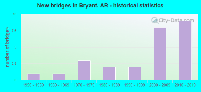
- New bridges - historical statistics
- 11950-1959
- 11960-1969
- 31970-1979
- 21980-1989
- 21990-1999
- 82000-2009
- 92010-2019
FCC Registered Antenna Towers:
47 (See the full list of FCC Registered Antenna Towers in Bryant)FCC Registered Broadcast Land Mobile Towers:
6- Lat: 34.585111 Lon: -92.509472, Call Sign: WNXH499,
Assigned Frequencies: 461.150 MHz, 462.237 MHz, 462.387 MHz, Grant Date: 08/16/2001, Expiration Date: 07/24/2011, Cancellation Date: 09/24/2011, Certifier: Timothy A Fox, Registrant: Pei Communications, 6007 S 31st Street, Ft Smith, AR 72908, Phone: (479) 646-6141, Fax: (479) 646-6142
- Lat: 34.622500 Lon: -92.498472, Call Sign: WQBG645,
Assigned Frequencies: 469.012 MHz, 469.212 MHz, 469.037 MHz, 469.237 MHz, 469.062 MHz, 469.262 MHz, 469.087 MHz, 469.287 MHz, Grant Date: 09/30/2004, Expiration Date: 09/30/2014, Cancellation Date: 12/06/2014, Certifier: Robert Mosesso, Registrant: R.F. Technologies Inc., 542 S Prairie Street, Bethalto, IL 62010, Phone: (800) 598-2370, Fax: (618) 377-1320, Email:
- Saline County Regional Airport, 1100 Hill (Lat: 34.587333 Lon: -92.484222), Type: Bant, Structure height: 6.5 m, Overall height: 6.7 m, Call Sign: WQRF754,
Assigned Frequencies: 453.062 MHz, Grant Date: 05/03/2013, Expiration Date: 05/03/2023, Cancellation Date: 07/15/2023, Certifier: Chad Lowry, Registrant: All Weather Inc, 1165 National Dr., Sacremanto, CA 95834, Phone: (916) 928-6748, Email:
- Lat: 34.585111 Lon: -92.509472, Call Sign: WQSE953,
Assigned Frequencies: 462.237 MHz, 462.387 MHz, Grant Date: 09/11/2013, Expiration Date: 09/11/2023, Cancellation Date: 11/11/2023, Certifier: Jason Rogers, Registrant: Washington Radio Reports, 1588 Fairfield Road Ste 7, Gettysburg, PA 17325, Phone: (717) 334-0668, Fax: (717) 334-6440, Email:
- Lat: 34.622389 Lon: -92.489083, Call Sign: WQTR245,
Assigned Frequencies: 451.187 MHz, 451.287 MHz, 451.487 MHz, 452.862 MHz, 457.712 MHz, Grant Date: 03/02/2024, Expiration Date: 03/26/2034, Certifier: Shawn Jackson, Registrant: Mj Communications, North Little Rock, AR 72231, Phone: (501) 945-9307, Fax: (501) 945-0333, Email:
- 1901 Encore Way (Lat: 34.612222 Lon: -92.520833), Type: Mast, Structure height: 18.3 m, Overall height: 22 m, Call Sign: WRKJ946,
Assigned Frequencies: 155.340 MHz, Grant Date: 01/13/2021, Expiration Date: 01/13/2031, Certifier: Diane Hughes, Registrant: Arkansas Valley Communications, 220 Smokey Lane, North Little Rock, AR 72117, Phone: (501) 904-8790, Email:
FCC Registered Microwave Towers:
2- STATION, 0.5 Mi S Of (Lat: 34.583694 Lon: -92.499861), Overall height: 20.7 m, Call Sign: WNTL617,
Assigned Frequencies: 952.781 MHz, 928.781 MHz, Grant Date: 12/14/2011, Expiration Date: 01/01/2022, Cancellation Date: 01/13/2021, Registrant: Mona Lee & Associates, LLC, 3730 Kirby Dr, Suite 1200 Pmb 165, Houston, TX 77098, Phone: (832) 850-7646, Email:
- AR0013BRYANT, 1010 N. Reynolds Rd (Lat: 34.604306 Lon: -92.490389), Type: Tower, Structure height: 49.4 m, Call Sign: WQLW377,
Assigned Frequencies: 21830.0 MHz, Grant Date: 05/10/2010, Expiration Date: 05/10/2020, Cancellation Date: 02/16/2012, Certifier: Dan Mieszala, Registrant: Open Range Communications Inc., 6430 S. Fiddlers Green Circle, Suite 500, Greenwood Village, CO 80111, Phone: (303) 376-2112, Fax: (303) 376-2109, Email:
FCC Registered Maritime Coast & Aviation Ground Towers:
2- 1100 Hill Farm Road (Lat: 34.588056 Lon: -92.482222), Type: Pole, Structure height: 3 m, Call Sign: WRMV373,
Assigned Frequencies: 119.600 MHz, 118.250 MHz, Grant Date: 06/09/2021, Expiration Date: 06/20/2021, Cancellation Date: 08/21/2021, Certifier: James Crum, Registrant: Air Boss, 18925 W Narramore Rd, Buckeye, AZ 85326, Phone: (229) 834-2599, Email:
- 1100 Hill Farm Rd (Lat: 34.588056 Lon: -92.482222), Type: Pole, Structure height: 3 m, Call Sign: WRTJ440,
Assigned Frequencies: 119.550 MHz, 118.450 MHz, Grant Date: 06/23/2022, Expiration Date: 06/25/2022, Cancellation Date: 08/27/2022, Certifier: Aj Ambort, Registrant: Saline County Reg Airport Air Boss, 7601 N 181st Ave, Waddell, AZ 85355, Phone: (229) 834-2599, Email:
FCC Registered Amateur Radio Licenses:
87 (See the full list of FCC Registered Amateur Radio Licenses in Bryant)FAA Registered Aircraft:
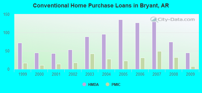
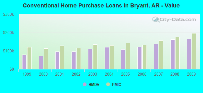
20 (See the full list of FAA Registered Aircraft in Bryant)| Home Mortgage Disclosure Act Aggregated Statistics For Year 2009 (Based on 3 partial tracts) | ||||||||||||||
| A) FHA, FSA/RHS & VA Home Purchase Loans | B) Conventional Home Purchase Loans | C) Refinancings | D) Home Improvement Loans | E) Loans on Dwellings For 5+ Families | F) Non-occupant Loans on < 5 Family Dwellings (A B C & D) | G) Loans On Manufactured Home Dwelling (A B C & D) | ||||||||
|---|---|---|---|---|---|---|---|---|---|---|---|---|---|---|
| Number | Average Value | Number | Average Value | Number | Average Value | Number | Average Value | Number | Average Value | Number | Average Value | Number | Average Value | |
| LOANS ORIGINATED | 95 | $154,686 | 45 | $166,587 | 138 | $153,966 | 13 | $52,629 | 1 | $7,843,600 | 16 | $133,115 | 4 | $36,718 |
| APPLICATIONS APPROVED, NOT ACCEPTED | 2 | $185,730 | 2 | $121,960 | 6 | $147,795 | 2 | $11,325 | 0 | $0 | 0 | $0 | 1 | $78,520 |
| APPLICATIONS DENIED | 13 | $156,815 | 5 | $101,470 | 43 | $150,677 | 8 | $50,274 | 0 | $0 | 2 | $55,720 | 3 | $50,917 |
| APPLICATIONS WITHDRAWN | 6 | $169,502 | 5 | $137,706 | 35 | $170,533 | 2 | $128,900 | 0 | $0 | 0 | $0 | 0 | $0 |
| FILES CLOSED FOR INCOMPLETENESS | 3 | $134,387 | 1 | $312,450 | 7 | $240,293 | 0 | $0 | 0 | $0 | 0 | $0 | 0 | $0 |
Detailed HMDA statistics for the following Tracts: 0101.03 , 0104.04, 0105.10
| Private Mortgage Insurance Companies Aggregated Statistics For Year 2009 (Based on 3 partial tracts) | ||||
| A) Conventional Home Purchase Loans | B) Refinancings | |||
|---|---|---|---|---|
| Number | Average Value | Number | Average Value | |
| LOANS ORIGINATED | 8 | $197,154 | 10 | $202,945 |
| APPLICATIONS APPROVED, NOT ACCEPTED | 2 | $134,890 | 1 | $290,210 |
| APPLICATIONS DENIED | 0 | $0 | 2 | $302,055 |
| APPLICATIONS WITHDRAWN | 0 | $0 | 0 | $0 |
| FILES CLOSED FOR INCOMPLETENESS | 0 | $0 | 0 | $0 |
Detailed PMIC statistics for the following Tracts: 0101.03 , 0104.04, 0105.10
2002 - 2018 National Fire Incident Reporting System (NFIRS) incidents
- Fire incident types reported to NFIRS in Bryant, AR
- 82949.0%Outside Fires
- 54732.3%Structure Fires
- 20812.3%Mobile Property/Vehicle Fires
- 1076.3%Other
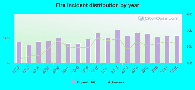 Based on the data from the years 2002 - 2018 the average number of fires per year is 99. The highest number of reported fires - 130 took place in 2012, and the least - 72 in 2003. The data has an increasing trend.
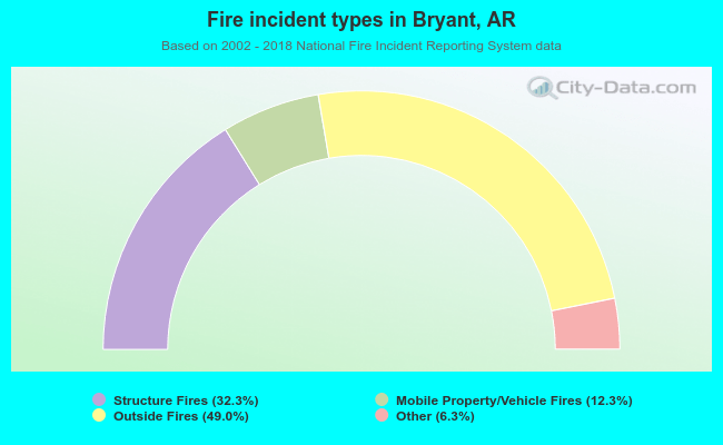 When looking into fire subcategories, the most reports belonged to: Outside Fires (49.0%), and Structure Fires (32.3%).
Fire-safe hotels and motels in Bryant, Arkansas:
- Country Inn & Suites, 2915 Main St, Bryant, Arkansas 72022 , Phone: (501) 847-0900
- Vista Inn & Suites, 210 Ofc Park Dr, Bryant, Arkansas 72022 , Phone: (501) 847-7120, Fax: (501) 847-7140
- Comfort Inn & Suites, 209 W Commerce St, Bryant, Arkansas 72022 , Phone: (501) 653-4000, Fax: (501) 653-0973
- Hometown Hotel, 2921 Main St, Bryant, Arkansas 72022 , Phone: (501) 653-0123, Fax: (501) 653-0124
- Hampton Inn, 307 Ofc Park Dr, Bryant, Arkansas 72022 , Phone: (501) 847-3200
- Americas Best Value Inn, 407 W Commerce St, Bryant, Arkansas 72022 , Phone: (501) 653-7800, Fax: (501) 847-8496
- La Quinta Inn & Suites, 408 W Commerce St, Bryant, Arkansas 72022 , Phone: (501) 847-9494, Fax: (501) 847-9496
- Holiday Inn Express, 7224 Alcoa Rd, Bryant, Arkansas 72022 , Phone: (800) 439-4745
| Most common first names in Bryant, AR among deceased individuals | ||
| Name | Count | Lived (average) |
|---|---|---|
| James | 31 | 76.3 years |
| John | 25 | 78.9 years |
| Mary | 23 | 75.0 years |
| William | 22 | 72.3 years |
| Robert | 17 | 68.4 years |
| Charles | 13 | 76.9 years |
| George | 12 | 73.2 years |
| Ruth | 12 | 78.9 years |
| Joe | 11 | 64.9 years |
| Paul | 11 | 71.6 years |
| Most common last names in Bryant, AR among deceased individuals | ||
| Last name | Count | Lived (average) |
|---|---|---|
| Smith | 18 | 81.6 years |
| Brown | 17 | 81.1 years |
| Davis | 13 | 76.8 years |
| Johnson | 12 | 83.4 years |
| Jones | 11 | 76.4 years |
| Moore | 11 | 78.5 years |
| Green | 11 | 72.3 years |
| Harris | 10 | 80.1 years |
| Elrod | 9 | 79.0 years |
| Anderson | 8 | 79.4 years |
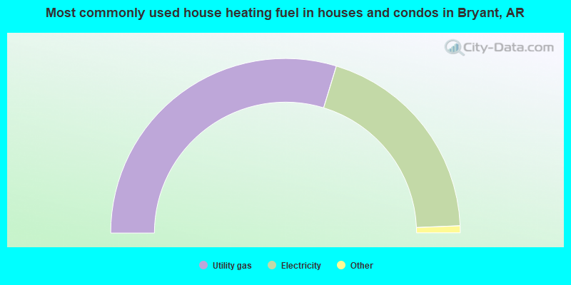
- 59.4%Utility gas
- 39.3%Electricity
- 0.5%Bottled, tank, or LP gas
- 0.5%Wood
- 0.3%Fuel oil, kerosene, etc.
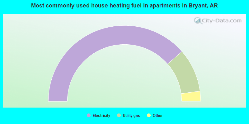
- 77.2%Electricity
- 18.5%Utility gas
- 3.0%Wood
- 0.9%No fuel used
- 0.4%Bottled, tank, or LP gas
Bryant compared to Arkansas state average:
- Unemployed percentage significantly below state average.
- Black race population percentage above state average.
- Length of stay since moving in above state average.
- House age below state average.
- Percentage of population with a bachelor's degree or higher above state average.
Bryant on our top lists:
- #67 on the list of "Top 101 cities with largest percentage of males in occupations: health technologists and technicians (population 5,000+)"
- #16 on the list of "Top 101 counties with the largest number of people moving in compared to moving out (pop. 50,000+)"
- #77 on the list of "Top 101 counties with highest percentage of residents voting for 3rd party candidates in the 2012 Presidential Election (pop. 50,000+)"
- #99 on the list of "Top 101 counties with highest percentage of residents voting for Romney (Republican) in the 2012 Presidential Election (pop. 50,000+)"

|
|
Total of 22 patent applications in 2008-2024.