Chesapeake, West Virginia
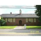
Chesapeake: Elementary School
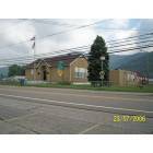
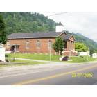
Chesapeake: City Hall
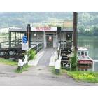
Chesapeake: Waterfront Marina
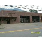
Chesapeake: Chesapeake Vol. Fire Department
Chesapeake: Freewill Babtist Church

Chesapeake: Waterfront Marina 2
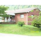
Chesapeake: Resident
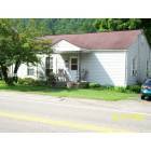
Chesapeake: Resident 2
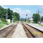
Chesapeake: CXS Mainline Railroad

Chesapeake
- add
your
Submit your own pictures of this town and show them to the world
(27.0% for White Non-Hispanic residents, 75.9% for Black residents, 20.0% for other race residents, 5.6% for two or more races residents)
Detailed information about poverty and poor residents in Chesapeake, WV
Full-time law enforcement employees in 2021, including police officers: 1 (1 officers - 1 male; 0 female).
| Officers per 1,000 residents here: | 0.73 |
| West Virginia average: | 1.95 |
 Recent articles from our blog. Our writers, many of them Ph.D. graduates or candidates, create easy-to-read articles on a wide variety of topics.
| Here: | 3.7% |
| West Virginia: | 4.0% |
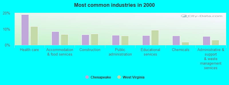
- Health care (19.1%)
- Accommodation & food services (8.5%)
- Construction (6.6%)
- Public administration (6.3%)
- Educational services (5.9%)
- Chemicals (5.8%)
- Administrative & support & waste management services (5.5%)
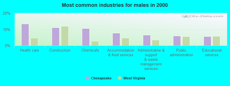
- Health care (13.5%)
- Construction (11.2%)
- Chemicals (10.6%)
- Accommodation & food services (7.7%)
- Administrative & support & waste management services (6.6%)
- Public administration (6.0%)
- Educational services (5.7%)
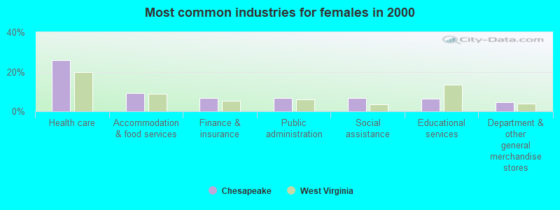
- Health care (25.9%)
- Accommodation & food services (9.3%)
- Finance & insurance (6.9%)
- Public administration (6.6%)
- Social assistance (6.6%)
- Educational services (6.2%)
- Department & other general merchandise stores (4.5%)
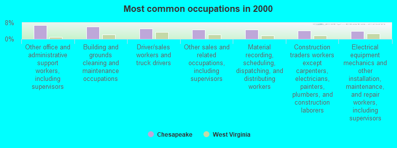
- Other office and administrative support workers, including supervisors (6.9%)
- Building and grounds cleaning and maintenance occupations (5.9%)
- Driver/sales workers and truck drivers (5.0%)
- Other sales and related occupations, including supervisors (4.5%)
- Material recording, scheduling, dispatching, and distributing workers (4.5%)
- Construction traders workers except carpenters, electricians, painters, plumbers, and construction laborers (4.2%)
- Electrical equipment mechanics and other installation, maintenance, and repair workers, including supervisors (3.9%)
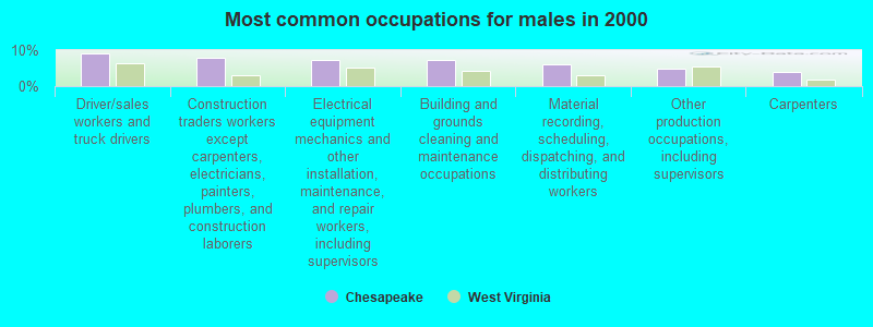
- Driver/sales workers and truck drivers (9.2%)
- Construction traders workers except carpenters, electricians, painters, plumbers, and construction laborers (7.7%)
- Electrical equipment mechanics and other installation, maintenance, and repair workers, including supervisors (7.2%)
- Building and grounds cleaning and maintenance occupations (7.2%)
- Material recording, scheduling, dispatching, and distributing workers (6.0%)
- Other production occupations, including supervisors (4.9%)
- Carpenters (4.0%)
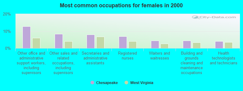
- Other office and administrative support workers, including supervisors (12.8%)
- Other sales and related occupations, including supervisors (8.3%)
- Secretaries and administrative assistants (7.9%)
- Registered nurses (6.9%)
- Waiters and waitresses (4.5%)
- Building and grounds cleaning and maintenance occupations (4.5%)
- Health technologists and technicians (4.1%)
Average climate in Chesapeake, West Virginia
Based on data reported by over 4,000 weather stations


(lower is better)
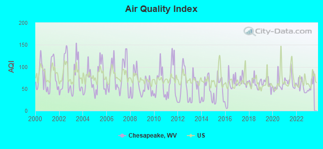
Air Quality Index (AQI) level in 2022 was 54.5. This is better than average.
| City: | 54.5 |
| U.S.: | 72.6 |
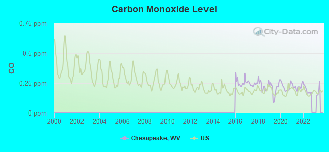
Carbon Monoxide (CO) [ppm] level in 2022 was 0.193. This is better than average. Closest monitor was 9.5 miles away from the city center.
| City: | 0.193 |
| U.S.: | 0.251 |
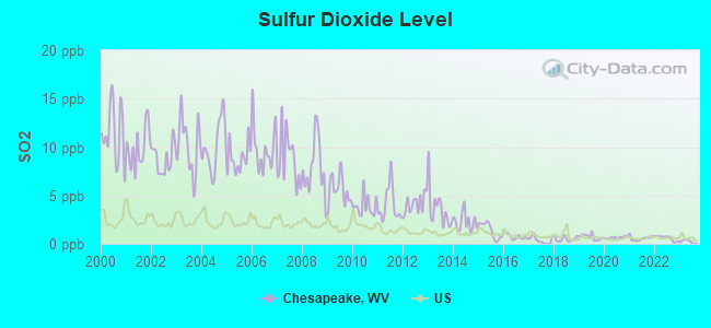
Sulfur Dioxide (SO2) [ppb] level in 2022 was 0.596. This is significantly better than average. Closest monitor was 8.8 miles away from the city center.
| City: | 0.596 |
| U.S.: | 1.515 |
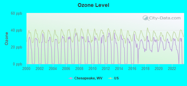
Ozone [ppb] level in 2022 was 21.7. This is significantly better than average. Closest monitor was 9.5 miles away from the city center.
| City: | 21.7 |
| U.S.: | 33.3 |
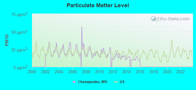
Particulate Matter (PM10) [µg/m3] level in 2015 was 11.1. This is significantly better than average. Closest monitor was 9.9 miles away from the city center.
| City: | 11.1 |
| U.S.: | 19.2 |
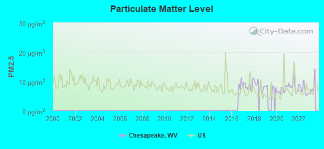
Particulate Matter (PM2.5) [µg/m3] level in 2022 was 7.21. This is about average. Closest monitor was 9.7 miles away from the city center.
| City: | 7.21 |
| U.S.: | 8.11 |
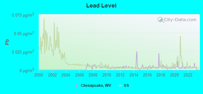
Lead (Pb) [µg/m3] level in 2022 was 0.00387. This is significantly better than average. Closest monitor was 2.3 miles away from the city center.
| City: | 0.00387 |
| U.S.: | 0.00931 |
Tornado activity:
Chesapeake-area historical tornado activity is below West Virginia state average. It is 78% smaller than the overall U.S. average.
On 4/23/1968, a category F5 (max. wind speeds 261-318 mph) tornado 54.8 miles away from the Chesapeake town center killed 7 people and injured 93 people and caused between $500,000 and $5,000,000 in damages.
On 4/4/1974, a category F3 (max. wind speeds 158-206 mph) tornado 40.6 miles away from the town center killed one person and injured 11 people and caused between $500,000 and $5,000,000 in damages.
Earthquake activity:
Chesapeake-area historical earthquake activity is significantly above West Virginia state average. It is 8% smaller than the overall U.S. average.On 8/23/2011 at 17:51:04, a magnitude 5.8 (5.8 MW, Depth: 3.7 mi, Class: Moderate, Intensity: VI - VII) earthquake occurred 197.2 miles away from Chesapeake center
On 7/27/1980 at 18:52:21, a magnitude 5.2 (5.1 MB, 4.7 MS, 5.0 UK, 5.2 UK) earthquake occurred 130.8 miles away from Chesapeake center
On 8/9/2020 at 12:07:37, a magnitude 5.1 (5.1 MW, Depth: 4.7 mi) earthquake occurred 123.3 miles away from Chesapeake center
On 9/25/1998 at 19:52:52, a magnitude 5.2 (4.8 MB, 4.3 MS, 5.2 LG, 4.5 MW, Depth: 3.1 mi) earthquake occurred 234.0 miles away from Chesapeake center
On 9/7/1988 at 02:28:09, a magnitude 4.6 (4.5 MB, 4.6 LG, Class: Light, Intensity: IV - V) earthquake occurred 127.4 miles away from Chesapeake center
On 11/2/2006 at 17:53:02, a magnitude 4.3 (4.3 MB, Depth: 0.6 mi) earthquake occurred 73.8 miles away from the city center
Magnitude types: regional Lg-wave magnitude (LG), body-wave magnitude (MB), surface-wave magnitude (MS), moment magnitude (MW)
Natural disasters:
The number of natural disasters in Kanawha County (28) is a lot greater than the US average (15).Major Disasters (Presidential) Declared: 22
Emergencies Declared: 5
Causes of natural disasters: Floods: 15, Storms: 14, Landslides: 8, Winter Storms: 5, Hurricanes: 3, Mudslides: 3, Blizzard: 1, Fire: 1, Heavy Rain: 1, Snowfall: 1, Snowstorm: 1, Tornado: 1, Wind: 1, Other: 2 (Note: some incidents may be assigned to more than one category).
Hospitals and medical centers near Chesapeake:
- HIGHLAND HOSPITAL (Hospital, about 7 miles away; CHARLESTON, WV)
- HEARTLAND OF CHARLESTON (Nursing Home, about 8 miles away; CHARLESTON, WV)
- FMS - CHARLESTON (Dialysis Facility, about 9 miles away; CHARLESTON, WV)
- AMEDISYS HOME HEALTH OF WEST VIRGINIA (Home Health Center, about 9 miles away; CHARLESTON, WV)
- EAST END GROUP HOME (Hospital, about 10 miles away; CHARLESTON, WV)
- OAK RIDGE CENTER (Nursing Home, about 10 miles away; CHARLESTON, WV)
- CHARLESTON AREA MEDICAL CENTER Acute Care Hospitals (about 10 miles away; CHARLESTON, WV)
Airports located in Chesapeake:
- Island Airport (WV08) (Runways: 1)
Amtrak stations near Chesapeake:
- 11 miles: CHARLESTON (350 MCCORKLE AVE. SE) . Services: ticket office, fully wheelchair accessible, enclosed waiting area, public restrooms, public payphones, vending machines, free short-term parking, free long-term parking, call for taxi service, public transit connection.
- 12 miles: MONTGOMERY (WASHINGTON ST. & 3RD AVE.) . Services: public payphones, free short-term parking, free long-term parking, call for taxi service, public transit connection.
Colleges/universities with over 2000 students nearest to Chesapeake:
- West Virginia State University (about 17 miles; Institute, WV; Full-time enrollment: 2,133)
- New River Community and Technical College (about 35 miles; Beckley, WV; FT enrollment: 2,234)
- Marshall University (about 51 miles; Huntington, WV; FT enrollment: 11,450)
- Concord University (about 63 miles; Athens, WV; FT enrollment: 2,698)
- Ashland Community and Technical College (about 63 miles; Ashland, KY; FT enrollment: 2,482)
- West Virginia University at Parkersburg (about 69 miles; Parkersburg, WV; FT enrollment: 2,619)
- Big Sandy Community and Technical College (about 78 miles; Prestonsburg, KY; FT enrollment: 2,660)
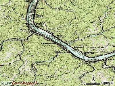
Points of interest:
Notable locations in Chesapeake: Chesapeake City Hall (A), Chesapeake Volunteer Fire Department (B). Display/hide their locations on the map
Creek: Fields Creek (A). Display/hide its location on the map
Birthplace of: Chris Massey - Football player.
| This town: | 2.2 people |
| West Virginia: | 2.4 people |
| This town: | 61.5% |
| Whole state: | 65.8% |
| This town: | 5.9% |
| Whole state: | 6.6% |
Likely homosexual households (counted as self-reported same-sex unmarried-partner households)
- Lesbian couples: 0.3% of all households
- Gay men: 0.3% of all households
| Here: | 9.3 |
| West Virginia average: | 11.1 |
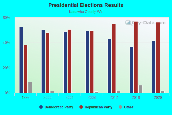
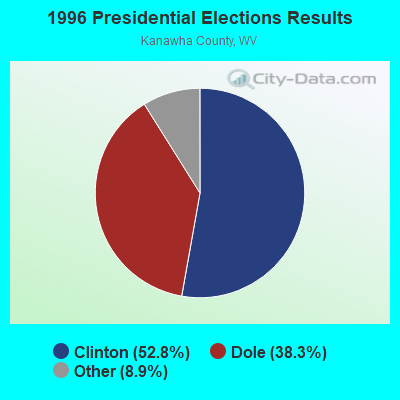
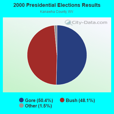
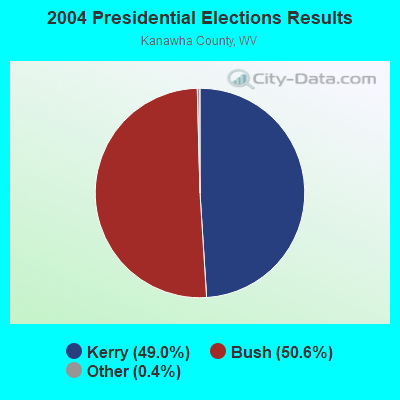
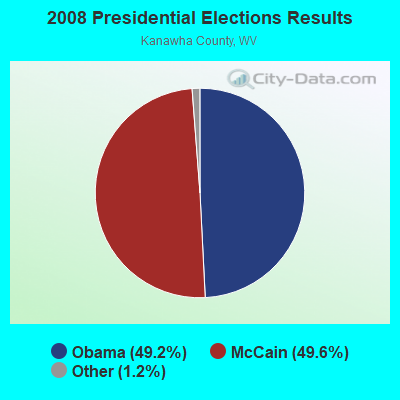
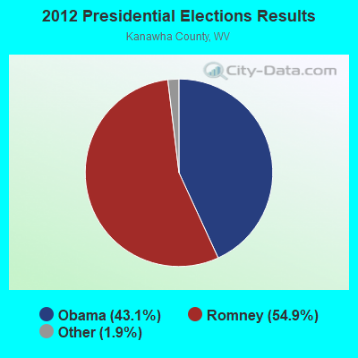
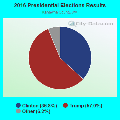
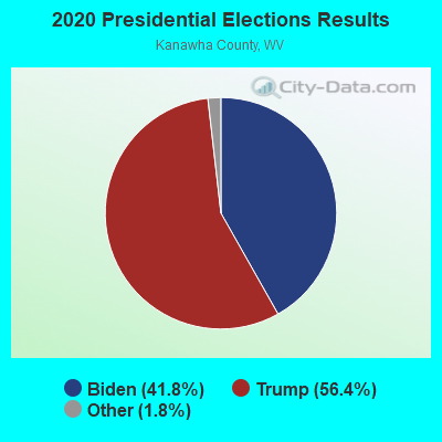
Graphs represent county-level data. Detailed 2008 Election Results
Religion statistics for Chesapeake, WV (based on Kanawha County data)
| Religion | Adherents | Congregations |
|---|---|---|
| Evangelical Protestant | 31,202 | 219 |
| Mainline Protestant | 27,583 | 114 |
| Catholic | 7,331 | 11 |
| Black Protestant | 3,114 | 12 |
| Other | 2,020 | 10 |
| Orthodox | 1,136 | 2 |
| None | 120,677 | - |
Food Environment Statistics:
| Kanawha County: | 2.46 / 10,000 pop. |
| West Virginia: | 2.41 / 10,000 pop. |
| Kanawha County: | 0.16 / 10,000 pop. |
| West Virginia: | 0.28 / 10,000 pop. |
| This county: | 0.52 / 10,000 pop. |
| State: | 1.09 / 10,000 pop. |
| Kanawha County: | 5.13 / 10,000 pop. |
| State: | 5.38 / 10,000 pop. |
| This county: | 6.90 / 10,000 pop. |
| West Virginia: | 6.22 / 10,000 pop. |
| Kanawha County: | 12.1% |
| West Virginia: | 12.2% |
| Here: | 29.6% |
| West Virginia: | 31.1% |
| This county: | 12.0% |
| West Virginia: | 13.1% |
Health and Nutrition:
| Chesapeake: | 49.2% |
| West Virginia: | 51.8% |
| This city: | 43.6% |
| State: | 49.7% |
| This city: | 29.1 |
| State: | 28.6 |
| This city: | 18.9% |
| West Virginia: | 20.4% |
| Chesapeake: | 9.4% |
| State: | 9.7% |
| Here: | 6.8 |
| West Virginia: | 6.9 |
| Chesapeake: | 30.6% |
| West Virginia: | 34.8% |
| This city: | 56.4% |
| State: | 58.4% |
| This city: | 76.3% |
| West Virginia: | 78.6% |
More about Health and Nutrition of Chesapeake, WV Residents
| Local government employment and payroll (March 2022) | |||||
| Function | Full-time employees | Monthly full-time payroll | Average yearly full-time wage | Part-time employees | Monthly part-time payroll |
|---|---|---|---|---|---|
| Solid Waste Management | 5 | $8,969 | $21,526 | 0 | $0 |
| Police Protection - Officers | 5 | $12,726 | $30,542 | 0 | $0 |
| Other Government Administration | 2 | $5,624 | $33,744 | 19 | $4,517 |
| Sewerage | 1 | $3,965 | $47,580 | 0 | $0 |
| Financial Administration | 0 | $0 | 1 | $627 | |
| Judicial and Legal | 0 | $0 | 1 | $627 | |
| Totals for Government | 13 | $31,284 | $28,878 | 21 | $5,771 |
Chesapeake government finances - Expenditure in 2021 (per resident):
- Current Operations - Sewerage: $423,000 ($326.14)
Police Protection: $220,000 ($169.62)
Central Staff Services: $61,000 ($47.03)
Financial Administration: $56,000 ($43.18)
General - Other: $32,000 ($24.67)
Regular Highways: $19,000 ($14.65)
Protective Inspection and Regulation - Other: $15,000 ($11.57)
Parks and Recreation: $11,000 ($8.48)
Miscellaneous Commercial Activities - Other: $5,000 ($3.86)
Judicial and Legal Services: $4,000 ($3.08)
Local Fire Protection: $1,000 ($0.77)
- General - Interest on Debt: $54,000 ($41.63)
- Other Capital Outlay - General Public Building: $101,000 ($77.87)
Solid Waste Management: $7,000 ($5.40)
Police Protection: $7,000 ($5.40)
- Total Salaries and Wages: $244,000 ($188.13)
Chesapeake government finances - Revenue in 2021 (per resident):
- Charges - Sewerage: $520,000 ($400.93)
Miscellaneous Commercial Activities: $14,000 ($10.79)
Other: $6,000 ($4.63)
- Miscellaneous - General Revenue - Other: $97,000 ($74.79)
Fines and Forfeits: $25,000 ($19.28)
Interest Earnings: $1,000 ($0.77)
- State Intergovernmental - General Local Government Support: $8,000 ($6.17)
- Tax - Property: $222,000 ($171.16)
Occupation and Business License - Other: $185,000 ($142.64)
Public Utilities Sales: $71,000 ($54.74)
Other License: $18,000 ($13.88)
Alcoholic Beverage Sales: $4,000 ($3.08)
Chesapeake government finances - Debt in 2021 (per resident):
- Long Term Debt - Beginning Outstanding - Unspecified Public Purpose: $2,013,000 ($1552.04)
Outstanding Unspecified Public Purpose: $1,878,000 ($1447.96)
Retired Unspecified Public Purpose: $135,000 ($104.09)
Chesapeake government finances - Cash and Securities in 2021 (per resident):
- Other Funds - Cash and Securities: $812,000 ($626.06)
- Sinking Funds - Cash and Securities: $256,000 ($197.38)
Strongest AM radio stations in Chesapeake:
- WCAW (680 AM; 10 kW; CHARLESTON, WV; Owner: WEST VIRGINIA RADIO CORPORATION OF CHARLESTON)
- WCHS (580 AM; 5 kW; CHARLESTON, WV; Owner: WEST VIRGINIA RADIO CORPORATION OF CHARLESTON)
- WVTS (950 AM; 5 kW; CHARLESTON, WV; Owner: BRISTOL BROADCASTING COMPANY, INC.)
- WSCW (1410 AM; daytime; 5 kW; SOUTH CHARLESTON, WV; Owner: L.M. COMMUNICATIONS OF KENTUCKY, LLC)
- WOAY (860 AM; 10 kW; OAK HILL, WV; Owner: COMMISSIONED COMMUNICATIONS, INC.)
- WIWS (1070 AM; daytime; 10 kW; BECKLEY, WV; Owner: SOUTHERN COMMUNICATIONS CORPORATION)
- WSWW (1490 AM; 1 kW; CHARLESTON, WV; Owner: WEST VIRGINIA RADIO CORPORATION OF CHARLESTON)
- WJLS (560 AM; 5 kW; BECKLEY, WV; Owner: FIRST MEDIA RADIO, LLC)
- WWNR (620 AM; 5 kW; BECKLEY, WV; Owner: DYNASTAR COMMUNICATIONS, INC.)
- WTVN (610 AM; 50 kW; COLUMBUS, OH; Owner: CITICASTERS LICENSES, L.P.)
- WMON (1340 AM; 1 kW; MONTGOMERY, WV; Owner: L.M. COMMUNICATIONS OF KENTUCKY, LLC)
- WBGS (1030 AM; daytime; 10 kW; POINT PLEASANT, WV; Owner: BIG RIVER RADIO, INC.)
- WBES (1240 AM; 1 kW; CHARLESTON, WV; Owner: BRISTOL BROADCASTING COMPANY, INC.)
Strongest FM radio stations in Chesapeake:
- WKAZ (107.3 FM; MIAMI, WV; Owner: WEST VIRGINIA RADIO CORPORATION OF CHARLESTON)
- WXAF (90.9 FM; CHARLESTON, WV; Owner: MARANATHA BROADCASTING, INC.)
- WKVW (93.3 FM; MONTGOMERY, WV; Owner: EDUCATIONAL MEDIA FOUNDATION)
- WVAF (99.9 FM; CHARLESTON, WV; Owner: WEST VIRGINIA RADIO CORPORATION OF CHARLESTON)
- WKWS (96.1 FM; CHARLESTON, WV; Owner: WEST VIRGINIA RADIO CORPORATION OF CHARLESTON)
- WCIR-FM (103.7 FM; BECKLEY, WV; Owner: SOUTHERN COMMUNICATIONS CORPORATION)
- WKLC-FM (105.1 FM; ST. ALBANS, WV; Owner: WKLC, INC.)
- WZAC-FM (92.5 FM; DANVILLE, WV; Owner: PRICE BROADCASTING COMPANY)
- WVSR-FM (102.7 FM; CHARLESTON, WV; Owner: BRISTOL BROADCASTING COMPANY, INC.)
- WRVZ (98.7 FM; POCATALICO, WV; Owner: WEST VIRGINIA RADIO CORPORATION OF CHARLESTON)
- WVPN (88.5 FM; CHARLESTON, WV; Owner: WEST VIRGINIA EDUCATIONAL BROADCASTING AUTHORITY)
- WQBE-FM (97.5 FM; CHARLESTON, WV; Owner: BRISTOL BROADCASTING COMPANY)
- WZJO (94.5 FM; DUNBAR, WV; Owner: BRISTOL BROADCASTING COMPANY, INC)
- WDBS (97.1 FM; SUTTON, WV; Owner: SUMMIT MEDIA BROADCASTING, L.L.C.)
- W208AK (89.5 FM; CHARLESTON, WV; Owner: LOWER OHIO VALLEY EDUCATIONAL CORP.)
- WJYP-FM (100.9 FM; SOUTH CHARLESTON, WV; Owner: L.M. COMMUNICATIONS OF KENTUCKY, LLC)
- WVWV (89.9 FM; HUNTINGTON, WV; Owner: WEST VIRGINIA EDUCATIONAL BROADCASTING AUTHORITY)
- WAMX (106.3 FM; MILTON, WV; Owner: CAPSTAR TX LIMITED PARTNERSHIP)
- WAXS (94.1 FM; OAK HILL, WV; Owner: PLATEAU BROADCASTING, INC.)
- WMTD-FM (102.3 FM; HINTON, WV; Owner: SOUTHERN COMMUNICATIONS CORPORATION)
TV broadcast stations around Chesapeake:
- WVAH-TV (Channel 11; CHARLESTON, WV; Owner: WVAH LICENSEE, LLC)
- WCHS-TV (Channel 8; CHARLESTON, WV; Owner: WCHS LICENSEE, LLC)
- WLPX-TV (Channel 29; CHARLESTON, WV; Owner: PAXSON CHARLESTON LICENSE, INC.)
- WPBY-TV (Channel 33; HUNTINGTON, WV; Owner: WEST VIRGINIA EDUCATIONAL BROADCASTING AUTHORITY)
- WSAZ-TV (Channel 3; HUNTINGTON, WV; Owner: EMMIS TELEVISION LICENSE CORPORATION)
- WOAY-TV (Channel 4; OAK HILL, WV; Owner: THOMAS BROADCASTING CO.)
- WOWK-TV (Channel 13; HUNTINGTON, WV; Owner: WEST VIRGINIA MEDIA HOLDINGS, LLC)
- W16CE (Channel 16; CHARLESTON, WV; Owner: EMMIS TELEVISION LICENSE CORPORATION)
- W31CA (Channel 31; CHARLESTON, WV; Owner: NATIONAL MINORITY T.V., INC.)
- Chesapeake, West Virginia
- Fatal accident count9
- Vehicles involved in fatal accidents12
- Fatal accidents involving drunk persons:2
- Fatalities9
- Persons involved in fatal accidents21
- Pedestrians involved in fatal accidents3
- West Virginia average
- Fatal accident count2583
- Vehicles involved in fatal accidents3736
- Fatal accidents involving drunk persons1040
- Fatalities2912
- Persons involved in fatal accidents6621
- Pedestrians involved in fatal accidents139
- National Bridge Inventory (NBI) Statistics
- 12Number of bridges
- 128ft / 38.5mTotal length
- $1,000,000Total costs
- 131,376Total average daily traffic
- 20,842Total average daily truck traffic
- New bridges - historical statistics
- 21970-1979
- 61980-1989
- 31990-1999
- 12000-2009
FCC Registered Broadcast Land Mobile Towers:
1- 12421 Venable Ave (Lat: 38.220111 Lon: -81.543167), Call Sign: WYC600,
Assigned Frequencies: 155.145 MHz, 155.745 MHz, Grant Date: 09/12/2023, Expiration Date: 11/14/2033, Registrant: Metro 911 Kanawha County Emergency Operations Center, 200 Peyton Way, Charleston, WV 25309-8627, Phone: (304) 746-7911, Fax: (304) 746-7914, Email:
FCC Registered Amateur Radio Licenses:
4- Call Sign: KC8ELD, Licensee ID: L01147287, Grant Date: 07/12/2016, Expiration Date: 07/24/2026, Certifier: Todd M Derreberry, Registrant: Todd M Derreberry, 13535 Ethel Ave, Chesapeake, WV 25315
- Call Sign: WB8OMJ, Licensee ID: L00204600, Grant Date: 04/29/1999, Expiration Date: 04/29/2009, Cancellation Date: 04/30/2011, Registrant: Dewitt Keyser, 137 22 Nancy Ave, Chesapeake, WV 25315
- Call Sign: KD8MLX, Licensee ID: L01531412, Grant Date: 11/20/2009, Expiration Date: 11/20/2019, Cancellation Date: 11/23/2021, Certifier: Joshua R Peal, Registrant: Joshua R Peal, 13 132nd Dt, Chesapeake, WV 25315
- Call Sign: KF8AFV, Licensee ID: L02749370, Grant Date: 02/22/2024, Expiration Date: 02/22/2034, Certifier: Todd S Taylor, Registrant: Todd S Taylor, 13505 Nancy Ave, Chesapeake, WV 25315-1521
| Home Mortgage Disclosure Act Aggregated Statistics For Year 2004 (Based on 1 partial tract) | ||
| C) Refinancings | ||
|---|---|---|
| Number | Average Value | |
| LOANS ORIGINATED | 0 | $0 |
| APPLICATIONS APPROVED, NOT ACCEPTED | 0 | $0 |
| APPLICATIONS DENIED | 1 | $28,980 |
| APPLICATIONS WITHDRAWN | 0 | $0 |
| FILES CLOSED FOR INCOMPLETENESS | 0 | $0 |
Detailed HMDA statistics for the following Tracts: 0122.00
2002 - 2018 National Fire Incident Reporting System (NFIRS) incidents
- Fire incident types reported to NFIRS in Chesapeake, WV
- 14763.9%Structure Fires
- 4820.9%Outside Fires
- 2812.2%Mobile Property/Vehicle Fires
- 73.0%Other
 Based on the data from the years 2002 - 2018 the average number of fire incidents per year is 14. The highest number of fire incidents - 37 took place in 2004, and the least - 0 in 2012. The data has an increasing trend.
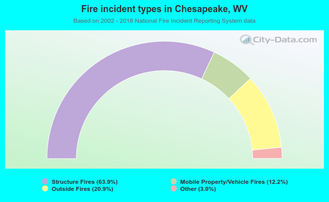 When looking into fire subcategories, the most incidents belonged to: Structure Fires (63.9%), and Outside Fires (20.9%).
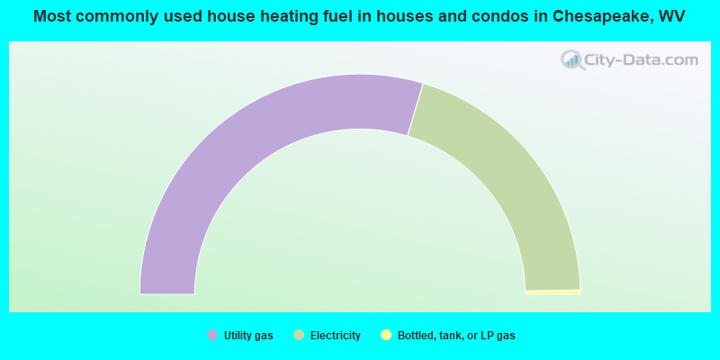
- 59.3%Utility gas
- 40.1%Electricity
- 0.6%Bottled, tank, or LP gas
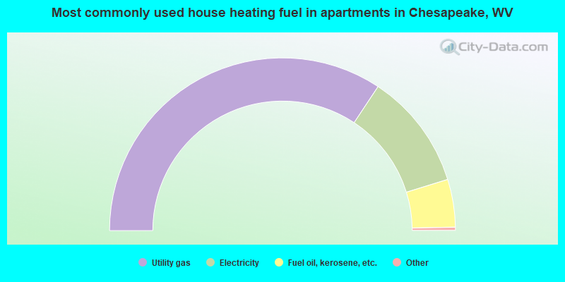
- 69.0%Utility gas
- 21.9%Electricity
- 9.0%Fuel oil, kerosene, etc.
Chesapeake compared to West Virginia state average:
- Median house value below state average.
- Black race population percentage above state average.
- Hispanic race population percentage below state average.
- Foreign-born population percentage significantly below state average.
- Length of stay since moving in significantly below state average.