Chester, Massachusetts
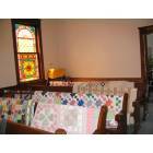
Chester: Quilt show in Chester Church
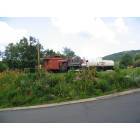
Chester: chester train station- garden by Chester Garden Club
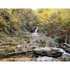
Chester: Sanderson Brook Falls
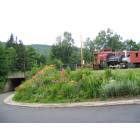
Chester: Train Depot with Garden Club garden
- add
your
Submit your own pictures of this town and show them to the world
Detailed information about poverty and poor residents in Chester, MA
Full-time law enforcement employees in 2021, including police officers: 1 (1 officers - 0 male; 1 female).
| Officers per 1,000 residents here: | 0.72 |
| Massachusetts average: | 2.53 |
 Recent articles from our blog. Our writers, many of them Ph.D. graduates or candidates, create easy-to-read articles on a wide variety of topics.
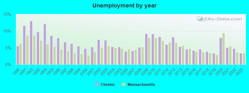
| Here: | 3.4% |
| Massachusetts: | 3.5% |
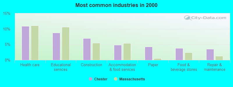
- Health care (10.9%)
- Educational services (8.7%)
- Construction (6.9%)
- Accommodation & food services (4.9%)
- Paper (4.3%)
- Food & beverage stores (3.8%)
- Repair & maintenance (3.5%)
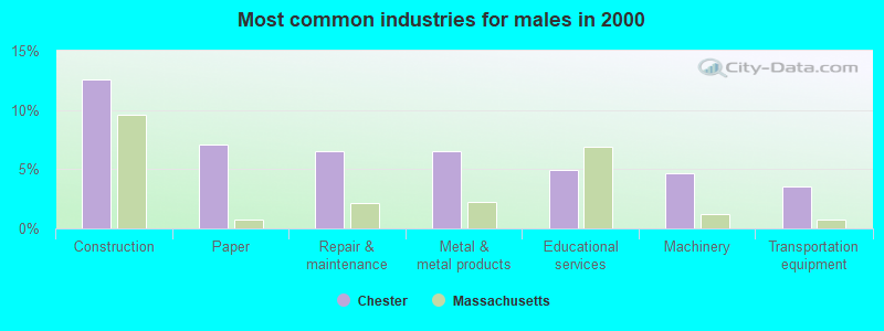
- Construction (12.5%)
- Paper (7.1%)
- Repair & maintenance (6.5%)
- Metal & metal products (6.5%)
- Educational services (4.9%)
- Machinery (4.6%)
- Transportation equipment (3.5%)
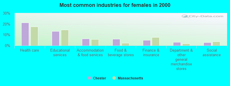
- Health care (21.3%)
- Educational services (13.2%)
- Accommodation & food services (6.5%)
- Food & beverage stores (6.1%)
- Finance & insurance (5.2%)
- Department & other general merchandise stores (3.2%)
- Social assistance (2.9%)
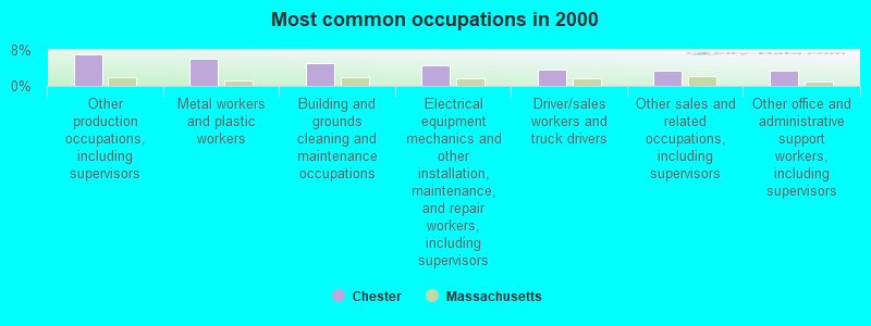
- Other production occupations, including supervisors (7.1%)
- Metal workers and plastic workers (6.1%)
- Building and grounds cleaning and maintenance occupations (5.2%)
- Electrical equipment mechanics and other installation, maintenance, and repair workers, including supervisors (4.7%)
- Driver/sales workers and truck drivers (3.5%)
- Other sales and related occupations, including supervisors (3.4%)
- Other office and administrative support workers, including supervisors (3.4%)
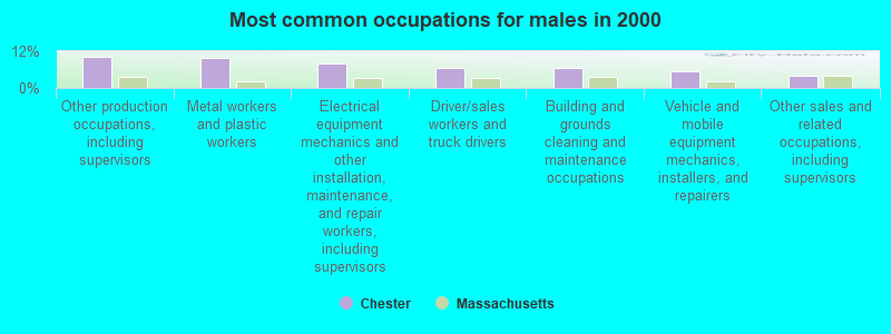
- Other production occupations, including supervisors (10.4%)
- Metal workers and plastic workers (9.8%)
- Electrical equipment mechanics and other installation, maintenance, and repair workers, including supervisors (8.2%)
- Driver/sales workers and truck drivers (6.5%)
- Building and grounds cleaning and maintenance occupations (6.5%)
- Vehicle and mobile equipment mechanics, installers, and repairers (5.4%)
- Other sales and related occupations, including supervisors (4.1%)
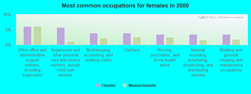
- Other office and administrative support workers, including supervisors (6.1%)
- Supervisors and other personal care and service workers, except child care workers (5.8%)
- Bookkeeping, accounting, and auditing clerks (3.9%)
- Cashiers (3.9%)
- Nursing, psychiatric, and home health aides (3.5%)
- Material recording, scheduling, dispatching, and distributing workers (3.5%)
- Building and grounds cleaning and maintenance occupations (3.5%)
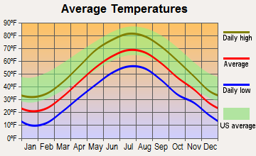
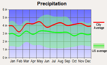
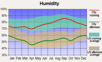
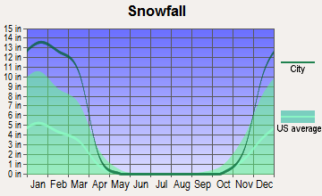
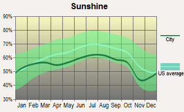
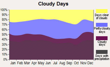
Average climate in Chester, Massachusetts
Based on data reported by over 4,000 weather stations

(lower is better)
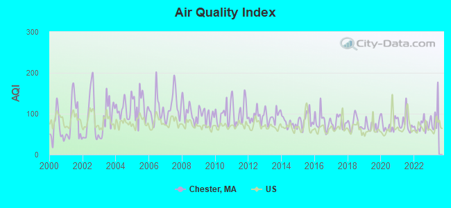
Air Quality Index (AQI) level in 2022 was 69.9. This is about average.
| City: | 69.9 |
| U.S.: | 72.6 |
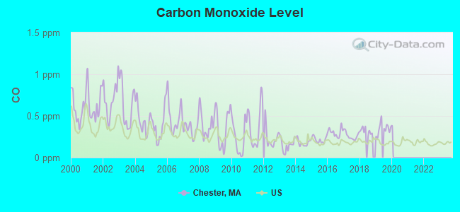
Carbon Monoxide (CO) [ppm] level in 2019 was 0.346. This is worse than average. Closest monitor was 18.3 miles away from the city center.
| City: | 0.346 |
| U.S.: | 0.251 |
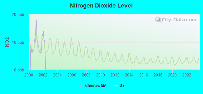
Nitrogen Dioxide (NO2) [ppb] level in 2001 was 9.83. This is significantly worse than average. Closest monitor was 16.0 miles away from the city center.
| City: | 9.83 |
| U.S.: | 5.11 |
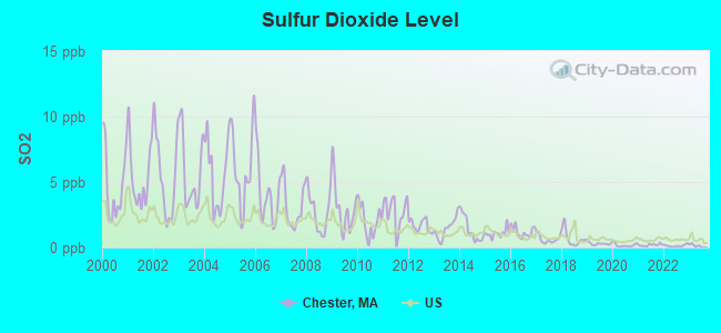
Sulfur Dioxide (SO2) [ppb] level in 2022 was 0.141. This is significantly better than average. Closest monitor was 15.9 miles away from the city center.
| City: | 0.141 |
| U.S.: | 1.515 |
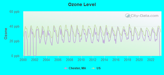
Ozone [ppb] level in 2022 was 27.9. This is about average. Closest monitor was 18.2 miles away from the city center.
| City: | 27.9 |
| U.S.: | 33.3 |
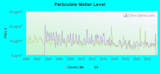
Particulate Matter (PM2.5) [µg/m3] level in 2022 was 6.81. This is about average. Closest monitor was 19.7 miles away from the city center.
| City: | 6.81 |
| U.S.: | 8.11 |
Tornado activity:
Chester-area historical tornado activity is above Massachusetts state average. It is 11% smaller than the overall U.S. average.
On 5/29/1995, a category F4 (max. wind speeds 207-260 mph) tornado 13.7 miles away from the Chester town center killed 3 people and injured 24 people and caused between $5,000,000 and $50,000,000 in damages.
On 10/3/1979, a category F4 tornado 19.8 miles away from the town center killed 3 people and injured 500 people and caused between $50,000,000 and $500,000,000 in damages.
Earthquake activity:
Chester-area historical earthquake activity is significantly above Massachusetts state average. It is 69% smaller than the overall U.S. average.On 10/7/1983 at 10:18:46, a magnitude 5.3 (5.1 MB, 5.3 LG, 5.1 ML, Class: Moderate, Intensity: VI - VII) earthquake occurred 136.0 miles away from the city center
On 4/20/2002 at 10:50:47, a magnitude 5.3 (5.3 ML, Depth: 3.0 mi) earthquake occurred 159.5 miles away from the city center
On 4/20/2002 at 10:50:47, a magnitude 5.2 (5.2 MB, 4.2 MS, 5.2 MW, 5.0 MW) earthquake occurred 158.0 miles away from Chester center
On 1/19/1982 at 00:14:42, a magnitude 4.7 (4.5 MB, 4.7 MD, 4.5 LG, Class: Light, Intensity: IV - V) earthquake occurred 108.7 miles away from the city center
On 10/16/2012 at 23:12:25, a magnitude 4.7 (4.7 ML, Depth: 10.0 mi) earthquake occurred 147.6 miles away from the city center
On 8/23/2011 at 17:51:04, a magnitude 5.8 (5.8 MW, Depth: 3.7 mi) earthquake occurred 401.0 miles away from the city center
Magnitude types: regional Lg-wave magnitude (LG), body-wave magnitude (MB), duration magnitude (MD), local magnitude (ML), surface-wave magnitude (MS), moment magnitude (MW)
Natural disasters:
The number of natural disasters in Hampden County (22) is greater than the US average (15).Major Disasters (Presidential) Declared: 12
Emergencies Declared: 9
Causes of natural disasters: Storms: 6, Floods: 5, Hurricanes: 5, Snowstorms: 4, Winter Storms: 4, Blizzards: 2, Snows: 2, Snowfall: 1, Tornado: 1, Tropical Storm: 1, Wind: 1, Other: 1 (Note: some incidents may be assigned to more than one category).
Hospitals and medical centers near Chester:
- OVERLOOK AT NORTHAMPTON (Nursing Home, about 14 miles away; LEEDS, MA)
- NORTHAMPTON VA MEDICAL CENTER (Hospital, Acute Care - Veterans Administration, about 14 miles away; LEEDS, MA)
- LINDA MANOR EXTENDED CARE FACILITY (Nursing Home, about 15 miles away; LEEDS, MA)
- NOBLE HOSPITAL Acute Care Hospitals (about 15 miles away; WESTFIELD, MA)
- NOBLE VISITING NURSE (Home Health Center, about 15 miles away; WESTFIELD, MA)
- BERKSHIRE HEALTH CARE CENTER (Nursing Home, about 15 miles away; SANDISFIELD, MA)
- GOVERNORS CENTER (Nursing Home, about 15 miles away; WESTFIELD, MA)
Colleges/universities with over 2000 students nearest to Chester:
- Westfield State University (about 13 miles; Westfield, MA; Full-time enrollment: 5,548)
- Smith College (about 16 miles; Northampton, MA; FT enrollment: 3,549)
- Holyoke Community College (about 16 miles; Holyoke, MA; FT enrollment: 4,911)
- Mount Holyoke College (about 19 miles; South Hadley, MA; FT enrollment: 2,573)
- Springfield Technical Community College (about 22 miles; Springfield, MA; FT enrollment: 4,750)
- American International College (about 23 miles; Springfield, MA; FT enrollment: 2,733)
- University of Massachusetts-Amherst (about 23 miles; Amherst, MA; FT enrollment: 26,583)
Public elementary/middle school in Chester:
- CHESTER ELEMENTARY (Students: 89, Location: 325 MIDDLEFIELD ROAD, Grades: PK-4)
Points of interest:
Notable locations in Chester: Chester Town Hall (A), Chester Fire Department Station 1 Headquarters (B). Display/hide their locations on the map
Streams, rivers, and creeks: Walker Brook (A), Austin Brook (B). Display/hide their locations on the map
Park in Chester: Chester Factory Village Historic District (1). Display/hide its location on the map
Tourist attraction: Chester Foundation (Museums; 10 Prospect Street).
Drinking water stations with addresses in Chester and their reported violations in the past:
CHESTER WATER DEPT (Population served: 750, Surface water):Past health violations:Past monitoring violations:
- MCL, Average - Between OCT-2011 and DEC-2011, Contaminant: TTHM. Follow-up actions: St AO (w/o penalty) issued (FEB-03-2012)
- MCL, Average - Between APR-2010 and JUN-2010, Contaminant: TTHM. Follow-up actions: St AO (w/penalty) issued (JUN-21-2010), St AO (w/o penalty) issued (NOV-28-2011)
- MCL, Average - Between JAN-2010 and MAR-2010, Contaminant: TTHM. Follow-up actions: St AO (w/o penalty) issued (APR-07-2010), St AO (w/penalty) issued (JUN-21-2010), St AO (w/o penalty) issued (NOV-28-2011)
- MCL, Average - Between OCT-2009 and DEC-2009, Contaminant: TTHM. Follow-up actions: St AO (w/o penalty) issued (2 times from MAR-03-2010 to APR-07-2010), St AO (w/penalty) issued (JUN-21-2010), St AO (w/o penalty) issued (NOV-28-2011)
- Follow-up Or Routine LCR Tap M/R - In JUN-01-2012, Contaminant: Lead and Copper Rule. Follow-up actions: St AO (w/o penalty) issued (JAN-18-2013)
- Record Keeping - In JUN-01-2012, Contaminant: IESWTR. Follow-up actions: St AO (w/o penalty) issued (AUG-10-2012)
- Monitoring and Reporting (DBP) - Between JUL-2009 and SEP-2009, Contaminant: Total Haloacetic Acids (HAA5). Follow-up actions: St AO (w/o penalty) issued (2 times from DEC-28-2009 to NOV-28-2011)
- 2 regular monitoring violations
| This town: | 2.5 people |
| Massachusetts: | 2.5 people |
| This town: | 68.9% |
| Whole state: | 63.0% |
| This town: | 7.6% |
| Whole state: | 7.0% |
Likely homosexual households (counted as self-reported same-sex unmarried-partner households)
- Lesbian couples: 0.2% of all households
- Gay men: 0.9% of all households
| This town: | 5.8% |
| Whole state: | 9.3% |
| This town: | 3.6% |
| Whole state: | 4.4% |
| Here: | 9.7 |
| Massachusetts average: | 13.1 |
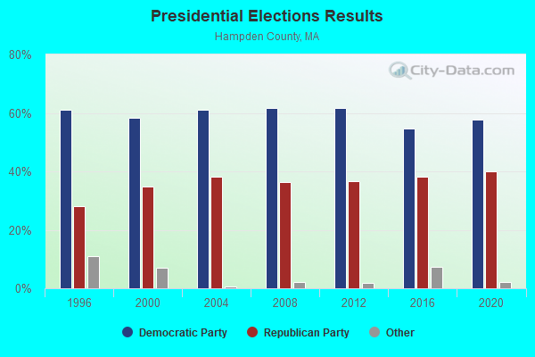
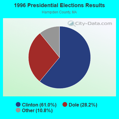
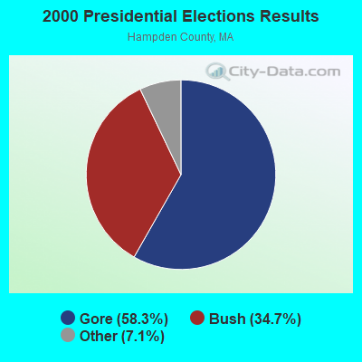
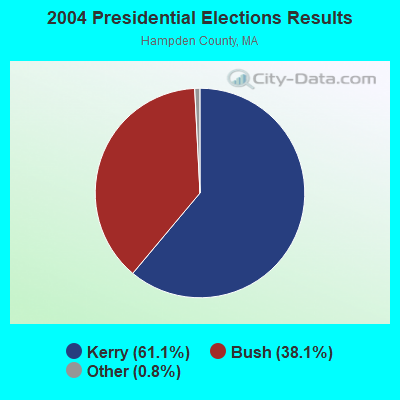
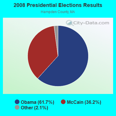
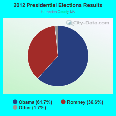
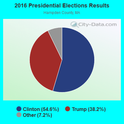
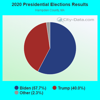
Graphs represent county-level data. Detailed 2008 Election Results
Religion statistics for Chester, MA (based on Hampden County data)
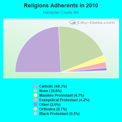
| Religion | Adherents | Congregations |
|---|---|---|
| Catholic | 223,685 | 65 |
| Mainline Protestant | 21,962 | 88 |
| Evangelical Protestant | 19,438 | 114 |
| Other | 9,140 | 31 |
| Orthodox | 3,406 | 10 |
| Black Protestant | 2,491 | 16 |
| None | 183,368 | - |
Food Environment Statistics:
| Hampden County: | 1.95 / 10,000 pop. |
| Massachusetts: | 1.98 / 10,000 pop. |
| Here: | 0.04 / 10,000 pop. |
| Massachusetts: | 0.05 / 10,000 pop. |
| Hampden County: | 1.87 / 10,000 pop. |
| Massachusetts: | 2.22 / 10,000 pop. |
| This county: | 2.43 / 10,000 pop. |
| Massachusetts: | 1.77 / 10,000 pop. |
| This county: | 7.27 / 10,000 pop. |
| Massachusetts: | 8.76 / 10,000 pop. |
| Hampden County: | 9.2% |
| Massachusetts: | 8.1% |
| Hampden County: | 25.9% |
| Massachusetts: | 22.5% |
| Hampden County: | 16.2% |
| Massachusetts: | 16.5% |
3.64% of this county's 2021 resident taxpayers lived in other counties in 2020 ($58,474 average adjusted gross income)
| Here: | 3.64% |
| Massachusetts average: | 6.35% |
0.02% of residents moved from foreign countries ($105 average AGI)
Hampden County: 0.02% Massachusetts average: 0.01%
Top counties from which taxpayers relocated into this county between 2020 and 2021:
| from Hampshire County, MA | |
| from Hartford County, CT | |
| from Worcester County, MA |
4.26% of this county's 2020 resident taxpayers moved to other counties in 2021 ($66,146 average adjusted gross income)
| Here: | 4.26% |
| Massachusetts average: | 7.18% |
0.03% of residents moved to foreign countries ($223 average AGI)
Hampden County: 0.03% Massachusetts average: 0.02%
Top counties to which taxpayers relocated from this county between 2020 and 2021:
| to Hampshire County, MA | |
| to Hartford County, CT | |
| to Worcester County, MA |
Strongest AM radio stations in Chester:
- WNNZ (640 AM; 50 kW; WESTFIELD, MA; Owner: CLEAR CHANNEL BROADCASTING LICENSES, INC.)
- WHYN (560 AM; 5 kW; SPRINGFIELD, MA; Owner: CLEAR CHANNEL BROADCASTING LICENSES, INC.)
- WTIC (1080 AM; 50 kW; HARTFORD, CT; Owner: INFINITY RADIO OPERATIONS INC.)
- WCRN (830 AM; 50 kW; WORCESTER, MA; Owner: CARTER BROADCASTING CORPORATION)
- WACE (730 AM; 5 kW; CHICOPEE, MA; Owner: CARTER BROADCASTING CORP.)
- WVNE (760 AM; daytime; 25 kW; LEICESTER, MA; Owner: BLOUNT MASSCOM, INC.)
- WGY (810 AM; 50 kW; SCHENECTADY, NY; Owner: CLEAR CHANNEL BROADCASTING LICENSES, INC.)
- WPTR (1540 AM; 50 kW; ALBANY, NY; Owner: KIMTRON, INC.)
- WUHN (1110 AM; daytime; 5 kW; PITTSFIELD, MA; Owner: WEINER BROADCASTING, INC.)
- WSPR (1270 AM; 5 kW; SPRINGFIELD, MA; Owner: ANTONIO F. AND HELENA R. GOIS, TENANTS BY THE ENTIRETY)
- WALE (990 AM; 50 kW; GREENVILLE, RI; Owner: NORTH AMERICAN BROADCASTING CO., INC.)
- WRKO (680 AM; 50 kW; BOSTON, MA; Owner: ENTERCOM BOSTON LICENSE, LLC)
- WIZZ (1520 AM; daytime; 10 kW; GREENFIELD, MA; Owner: P. & M. RADIO, LLC)
Strongest FM radio stations in Chester:
- WHYN-FM (93.1 FM; SPRINGFIELD, MA; Owner: CLEAR CHANNEL BROADCASTING LICENSES, INC.)
- WRNX (100.9 FM; AMHERST, MA; Owner: WESTERN MASSACHUSETTS RADIO COMPANY)
- WAMC-FM (90.3 FM; ALBANY, NY; Owner: WAMC)
- WAQY (102.1 FM; SPRINGFIELD, MA; Owner: SAGA COMMUNICATIONS OF NEW ENGLAND, LLC)
- WHVP (91.1 FM; HUDSON, NY; Owner: SOUND OF LIFE, INC.)
- WFCR (88.5 FM; AMHERST, MA; Owner: UNIVERSITY OF MASSACHUSETTS)
- WPKX (97.9 FM; ENFIELD, CT; Owner: CAPSTAR TX LIMITED PARTNERSHIP)
- WBEC-FM (105.5 FM; PITTSFIELD, MA; Owner: GREAT NORTHERN RADIO, LLC)
- WLZX (99.3 FM; NORTHAMPTON, MA; Owner: SAGA COMMUNICATIONS OF NEW ENGLAND, LLC)
- WAMQ (105.1 FM; GREAT BARRINGTON, MA; Owner: WAMC)
- WUPE (95.9 FM; PITTSFIELD, MA; Owner: WEINER BROADCASTING, INC.)
- WEQX (102.7 FM; MANCHESTER, VT; Owner: NORTHSHIRE COMMUNICATIONS, INC.)
- WJAN (95.1 FM; SUNDERLAND, VT; Owner: 6 JOHNSON ROAD LICENSES, INC.)
- WRCH (100.5 FM; NEW BRITAIN, CT; Owner: INFINITY RADIO OPERATIONS INC.)
- WAMH (89.3 FM; AMHERST, MA; Owner: TRUSTEES OF AMHERST COLLEGE)
- WVAY (100.7 FM; WILMINGTON, VT; Owner: GREAT NORTHERN RADIO, L.L.C.)
- WZEC (97.5 FM; HOOSICK FALLS, NY; Owner: GREAT NORTHERN RADIO, LLC)
- W246AM (97.1 FM; AMHERST, MA; Owner: GREAT NORTHERN RADIO, LLC)
- WEIB (106.3 FM; NORTHAMPTON, MA; Owner: CUTTING EDGE BROADCASTING, INC.)
- WPVQ (95.3 FM; GREENFIELD, MA; Owner: GREAT NORTHERN RADIO, L.L.C.)
TV broadcast stations around Chester:
- WTIC-TV (Channel 61; HARTFORD, CT; Owner: TRIBUNE TELEVISION COMPANY)
- W11BJ (Channel 11; HARTFORD, CT; Owner: COMMUNICATIONS SITE MANAGEMENT LLC)
- WWLP (Channel 22; SPRINGFIELD, MA; Owner: WWLP BROADCASTING, LLC)
- WUVN (Channel 18; HARTFORD, CT; Owner: ENTRAVISION HOLDINGS, LLC)
- WTXX (Channel 20; WATERBURY, CT; Owner: WTXX INC.)
- WYDN (Channel 48; WORCESTER, MA; Owner: EDUCATIONAL PUBLIC TV CORPORATION)
- W67DF (Channel 67; SPRINGFIELD, MA; Owner: TRINITY BROADCASTING NETWORK)
- WVIT (Channel 30; NEW BRITAIN, CT; Owner: OUTLET BROADCASTING, INC)
- WEDH (Channel 24; HARTFORD, CT; Owner: CONNECTICUT PUBLIC BROADCASTING, INC.)
- WGGB-TV (Channel 40; SPRINGFIELD, MA; Owner: WGGB LICENSEE, LLC)
- WGBY-TV (Channel 57; SPRINGFIELD, MA; Owner: WGBH EDUCATIONAL FOUNDATION)
- W35BK (Channel 35; PLAINFIELD, MA; Owner: LYDIA SYLVANE STOCKWELL)
- WDMR-LP (Channel 65; SPRINGFIELD, MA; Owner: ZGS HARTFORD, INC.)
- Chester, Massachusetts
- Fatal accident count10
- Vehicles involved in fatal accidents12
- Fatal accidents involving drunk persons:4
- Fatalities10
- Persons involved in fatal accidents16
- Pedestrians involved in fatal accidents0
- Massachusetts average
- Fatal accident count4454
- Vehicles involved in fatal accidents6329
- Fatal accidents involving drunk persons1617
- Fatalities4780
- Persons involved in fatal accidents10266
- Pedestrians involved in fatal accidents531
- National Bridge Inventory (NBI) Statistics
- 25Number of bridges
- 177ft / 54.2mTotal length
- $36,963,000Total costs
- 19,683Total average daily traffic
- 2,271Total average daily truck traffic
- 26,241Total future (year 2031) average daily traffic
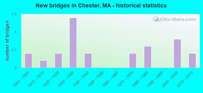
- New bridges - historical statistics
- 21900-1909
- 11910-1919
- 21920-1929
- 71930-1939
- 21940-1949
- 21970-1979
- 31980-1989
- 42000-2009
- 22010-2019
FCC Registered Microwave Towers:
2- Various Locations (Lat: 42.575083 Lon: -73.016194), Overall height: 2.4 m, Call Sign: WPNL767,
Assigned Frequencies: 956.393 MHz, Grant Date: 03/07/2003, Expiration Date: 03/30/2013, Cancellation Date: 06/01/2013, Phone: (412) 430-3974
- CHESTER FIRE, Skyline Trail (Lat: 42.324694 Lon: -72.957361), Type: Mast, Structure height: 21.9 m, Call Sign: WQNC840,
Assigned Frequencies: 6093.45 MHz, 6256.54 MHz, 10633.1 MHz, Grant Date: 09/29/2020, Expiration Date: 12/21/2030, Certifier: Charles B Sutherland, Registrant: Massachusetts, Commonwealth Of, 470 Worcester Rd, Framingham, MA 01702, Phone: (508) 820-2264, Email:
FCC Registered Amateur Radio Licenses:
10 (See the full list of FCC Registered Amateur Radio Licenses in Chester)2002 - 2018 National Fire Incident Reporting System (NFIRS) incidents
- Fire incident types reported to NFIRS in Chester, MA
- 5445.8%Structure Fires
- 4840.7%Outside Fires
- 119.3%Other
- 54.2%Mobile Property/Vehicle Fires
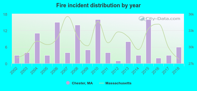 Based on the data from the years 2002 - 2018 the average number of fire incidents per year is 7. The highest number of fires - 16 took place in 2010, and the least - 1 in 2012. The data has an increasing trend.
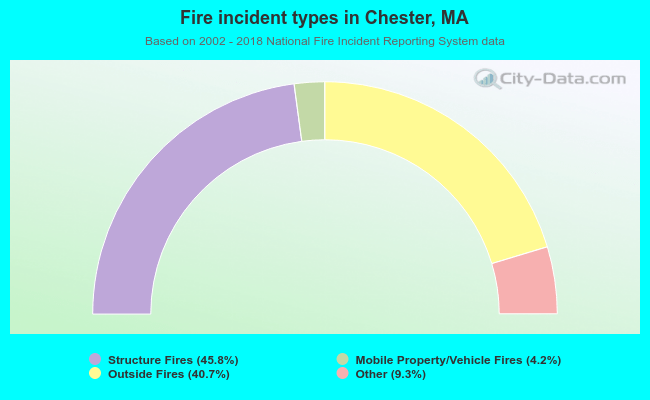 When looking into fire subcategories, the most incidents belonged to: Structure Fires (45.8%), and Outside Fires (40.7%).
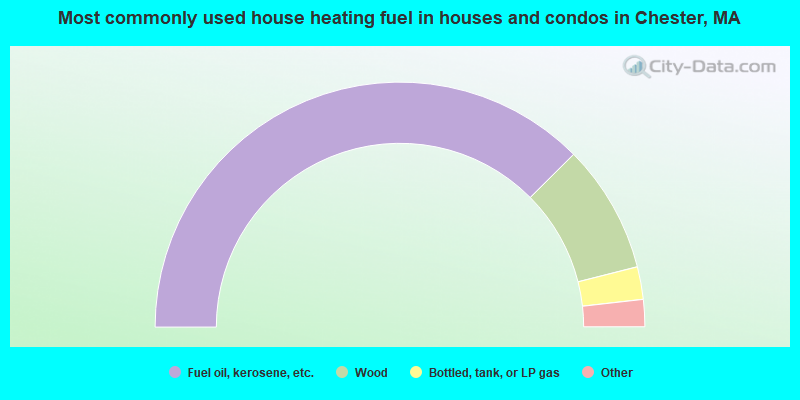
- 75.1%Fuel oil, kerosene, etc.
- 17.0%Wood
- 4.3%Bottled, tank, or LP gas
- 1.4%Electricity
- 1.2%Other fuel
- 0.5%Utility gas
- 0.5%No fuel used
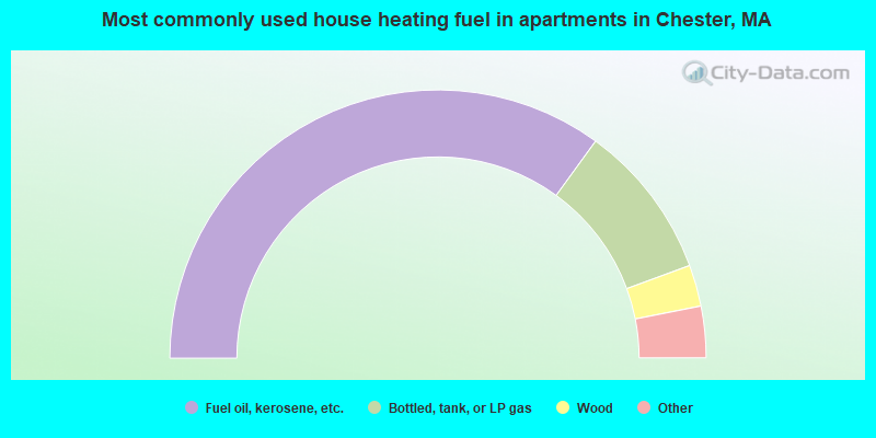
- 70.0%Fuel oil, kerosene, etc.
- 18.8%Bottled, tank, or LP gas
- 5.0%Wood
- 3.8%Other fuel
- 2.5%Electricity
Chester compared to Massachusetts state average:
- Median house value below state average.
- Unemployed percentage below state average.
- Black race population percentage significantly below state average.
- Hispanic race population percentage significantly below state average.
- Median age above state average.
- Foreign-born population percentage significantly below state average.
- Renting percentage significantly below state average.
- Length of stay since moving in significantly above state average.
- Number of rooms per house significantly below state average.
- House age significantly below state average.
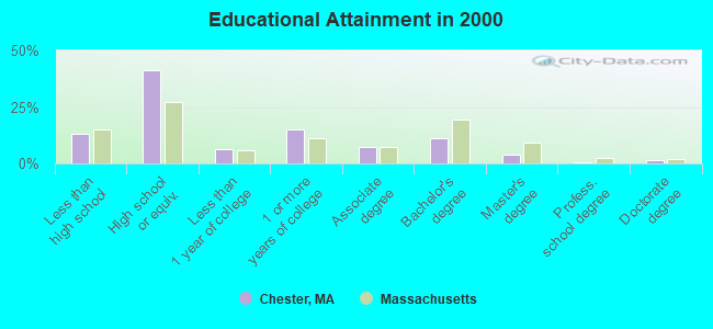
- Percentage of population with a bachelor's degree or higher below state average.

|
Total of 2 patent applications in 2008-2024.