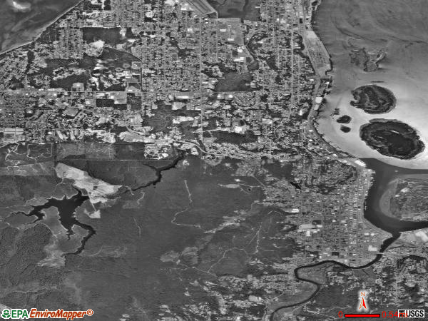
Coos Bay, Oregon
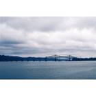
Coos Bay: Bridge
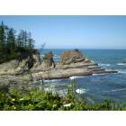
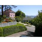
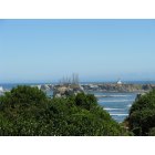
Coos Bay: Shore Acres
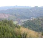
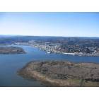
Coos Bay: Coos Bay Mountaintop View
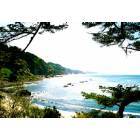
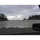
Coos Bay: Picture of coast, on the way to shore acres
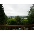
Coos Bay: View of Coos Bay looking to southwest. Taken Feb05
Coos Bay: Coos Bay Eastside
Coos Bay: Historical Downtown Coos Bay
Coos Bay: Sunset Beach in Coos Bay, OR
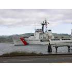
Coos Bay: coast guard in Coos Bay
Coos Bay: Cape Arago Lighthouse
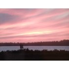
Coos Bay: Sunset at the bay
- see
21
more - add
your
Submit your own pictures of this city and show them to the world
- OSM Map
- General Map
- Google Map
- MSN Map

Population change since 2000: +3.0%
 |
| Males: 7,608 | |
| Females: 8,232 |
| Median resident age: | 43.4 years |
| Oregon median age: | 40.5 years |
Zip codes: 97459.
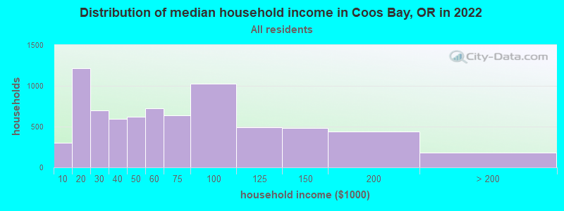
| Coos Bay: | $52,652 |
| OR: | $75,657 |
Estimated per capita income in 2022: $32,680 (it was $18,158 in 2000)
Coos Bay city income, earnings, and wages data
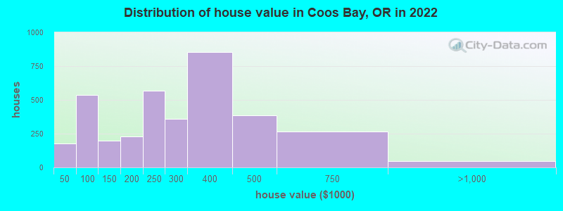
Estimated median house or condo value in 2022: $277,649 (it was $87,300 in 2000)
| Coos Bay: | $277,649 |
| OR: | $475,600 |
Mean prices in 2022: all housing units: $347,664; detached houses: $375,383; townhouses or other attached units: $364,753; in 2-unit structures: $291,799; in 3-to-4-unit structures: $330,318; in 5-or-more-unit structures: $446,164; mobile homes: $209,537; occupied boats, rvs, vans, etc.: $228,992
Median gross rent in 2022: $913.
(15.0% for White Non-Hispanic residents, 6.1% for Black residents, 6.4% for Hispanic or Latino residents, 47.4% for American Indian residents, 15.8% for two or more races residents)
Detailed information about poverty and poor residents in Coos Bay, OR


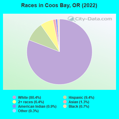
- 12,85280.4%White alone
- 1,4989.4%Hispanic
- 1,0176.4%Two or more races
- 2081.3%Asian alone
- 1500.9%American Indian alone
- 1180.7%Black alone
- 500.3%Other race alone
Races in Coos Bay detailed stats: ancestries, foreign born residents, place of birth
According to our research of Oregon and other state lists, there were 19 registered sex offenders living in Coos Bay, Oregon as of April 27, 2024.
The ratio of all residents to sex offenders in Coos Bay is 873 to 1.
Type |
2009 |
2010 |
2011 |
2012 |
2013 |
2014 |
2015 |
2016 |
2017 |
2018 |
2019 |
2020 |
2021 |
2022 |
|---|---|---|---|---|---|---|---|---|---|---|---|---|---|---|
| Murders (per 100,000) | 0 (0.0) | 0 (0.0) | 0 (0.0) | 0 (0.0) | 1 (6.3) | 0 (0.0) | 3 (18.7) | 0 (0.0) | 1 (6.1) | 0 (0.0) | 0 (0.0) | 0 (0.0) | 0 (0.0) | 1 (6.3) |
| Rapes (per 100,000) | 7 (44.6) | 9 (56.4) | 10 (62.0) | 1 (6.2) | 3 (19.0) | 9 (56.5) | 18 (112.1) | 21 (129.4) | 19 (116.2) | 7 (42.8) | 19 (115.4) | 15 (91.4) | 8 (48.8) | 13 (81.9) |
| Robberies (per 100,000) | 6 (38.2) | 10 (62.6) | 10 (62.0) | 3 (18.7) | 6 (37.9) | 10 (62.7) | 8 (49.8) | 13 (80.1) | 17 (104.0) | 8 (49.0) | 14 (85.0) | 18 (109.7) | 8 (48.8) | 12 (75.6) |
| Assaults (per 100,000) | 24 (152.8) | 45 (281.8) | 69 (427.6) | 28 (174.8) | 50 (316.1) | 33 (207.0) | 65 (404.8) | 26 (160.3) | 25 (152.9) | 31 (189.7) | 42 (255.0) | 52 (317.0) | 67 (409.1) | 72 (453.7) |
| Burglaries (per 100,000) | 107 (681.4) | 156 (977.0) | 141 (873.8) | 61 (380.9) | 166 (1,050) | 138 (865.8) | 114 (710.0) | 167 (1,029) | 201 (1,230) | 111 (679.2) | 171 (1,038) | 183 (1,116) | 142 (867.0) | 213 (1,342) |
| Thefts (per 100,000) | 509 (3,241) | 652 (4,083) | 650 (4,028) | 275 (1,717) | 745 (4,710) | 716 (4,492) | 856 (5,331) | 983 (6,059) | 874 (5,347) | 621 (3,800) | 587 (3,564) | 548 (3,341) | 527 (3,218) | 643 (4,051) |
| Auto thefts (per 100,000) | 44 (280.2) | 24 (150.3) | 24 (148.7) | 16 (99.9) | 54 (341.4) | 33 (207.0) | 33 (205.5) | 83 (511.6) | 178 (1,089) | 45 (275.3) | 36 (218.6) | 53 (323.1) | 58 (354.1) | 72 (453.7) |
| Arson (per 100,000) | 6 (38.2) | 3 (18.8) | 0 (0.0) | 1 (6.2) | 3 (19.0) | 5 (31.4) | 5 (31.1) | 7 (43.1) | 16 (97.9) | 7 (42.8) | 10 (60.7) | 39 (237.8) | 6 (36.6) | 11 (69.3) |
| City-Data.com crime index | 277.5 | 364.0 | 387.9 | 148.9 | 391.6 | 362.3 | 502.4 | 515.0 | 554.0 | 308.5 | 401.5 | 407.1 | 353.3 | 483.8 |
The City-Data.com crime index weighs serious crimes and violent crimes more heavily. Higher means more crime, U.S. average is 246.1. It adjusts for the number of visitors and daily workers commuting into cities.
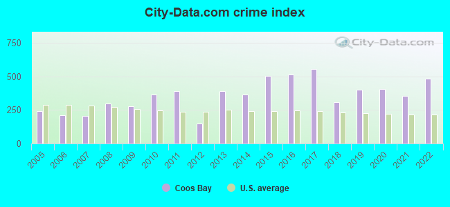
Crime rate in Coos Bay detailed stats: murders, rapes, robberies, assaults, burglaries, thefts, arson
Full-time law enforcement employees in 2021, including police officers: 39 (25 officers - 24 male; 1 female).
| Officers per 1,000 residents here: | 1.53 |
| Oregon average: | 1.48 |
 Recent articles from our blog. Our writers, many of them Ph.D. graduates or candidates, create easy-to-read articles on a wide variety of topics.

 | Coos Bay Medical Question (0 replies) |
| Coos Bay/ North Bend, Oregon living. (90 replies) |
| Coos Bay realtor? (0 replies) |
| Coos Bay Help!!! (4 replies) |
| Coos Bay vs Aberdeen WA for retirement (31 replies) |
| Need info about Coos Bay weather. Moving in Spring (45 replies) |
Latest news from Coos Bay, OR collected exclusively by city-data.com from local newspapers, TV, and radio stations
Coos Bay, OR City Guides:
Ancestries: American (13.5%), German (9.2%), Irish (8.9%), English (7.4%), European (6.9%), Scottish (2.6%).
Current Local Time: PST time zone
Elevation: 11 feet
Land area: 10.6 square miles.
Population density: 1,496 people per square mile (low).
777 residents are foreign born (3.1% Latin America, 1.1% Asia, 0.5% Europe).
| This city: | 4.9% |
| Oregon: | 9.8% |
Median real estate property taxes paid for housing units with mortgages in 2022: $2,326 (0.8%)
Median real estate property taxes paid for housing units with no mortgage in 2022: $1,935 (1.0%)
Nearest city with pop. 50,000+: Eugene, OR  (73.4 miles , pop. 137,893).
Nearest city with pop. 200,000+: Northwest Clackamas, OR (161.0 miles , pop. 224,220).
Nearest city with pop. 1,000,000+: Los Angeles, CA (715.7 miles , pop. 3,694,820).
Nearest cities:
), ), ), ), ), Latitude: 43.38 N, Longitude: 124.24 W
Daytime population change due to commuting: +3,134 (+19.6%)
Workers who live and work in this city: 4,189 (57.0%)
Area code: 541
Coos Bay, Oregon accommodation & food services, waste management - Economy and Business Data
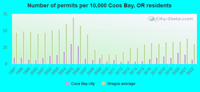
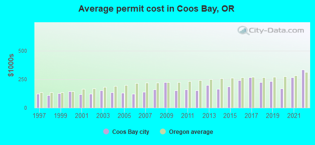
Single-family new house construction building permits:
- 2022: 11 buildings, average cost: $333,100
- 2021: 22 buildings, average cost: $264,800
- 2020: 26 buildings, average cost: $169,600
- 2019: 15 buildings, average cost: $232,200
- 2018: 18 buildings, average cost: $225,600
- 2017: 15 buildings, average cost: $267,600
- 2016: 12 buildings, average cost: $240,000
- 2015: 7 buildings, average cost: $184,600
- 2014: 6 buildings, average cost: $162,600
- 2013: 8 buildings, average cost: $196,900
- 2012: 5 buildings, average cost: $151,600
- 2011: 10 buildings, average cost: $158,800
- 2010: 6 buildings, average cost: $153,800
- 2009: 14 buildings, average cost: $224,200
- 2008: 10 buildings, average cost: $161,700
- 2007: 13 buildings, average cost: $138,200
- 2006: 42 buildings, average cost: $123,300
- 2005: 47 buildings, average cost: $131,400
- 2004: 29 buildings, average cost: $137,100
- 2003: 21 buildings, average cost: $153,500
- 2002: 20 buildings, average cost: $123,200
- 2001: 15 buildings, average cost: $119,900
- 2000: 9 buildings, average cost: $145,100
- 1999: 11 buildings, average cost: $127,700
- 1998: 15 buildings, average cost: $110,200
- 1997: 16 buildings, average cost: $123,900
| Here: | 4.7% |
| Oregon: | 3.9% |
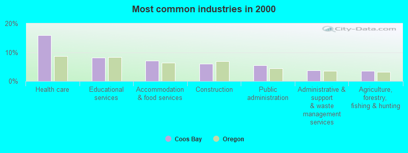
- Health care (15.9%)
- Educational services (8.2%)
- Accommodation & food services (7.0%)
- Construction (6.0%)
- Public administration (5.5%)
- Administrative & support & waste management services (3.8%)
- Agriculture, forestry, fishing & hunting (3.6%)
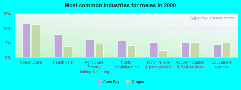
- Construction (11.5%)
- Health care (7.9%)
- Agriculture, forestry, fishing & hunting (6.2%)
- Public administration (5.7%)
- Motor vehicle & parts dealers (5.2%)
- Accommodation & food services (5.1%)
- Educational services (4.3%)
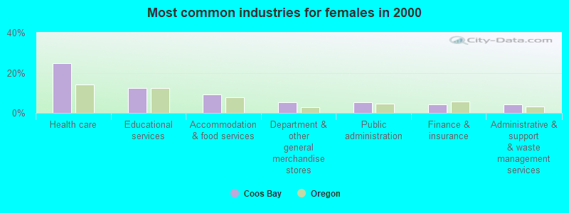
- Health care (24.8%)
- Educational services (12.4%)
- Accommodation & food services (9.1%)
- Department & other general merchandise stores (5.4%)
- Public administration (5.3%)
- Finance & insurance (4.2%)
- Administrative & support & waste management services (4.1%)
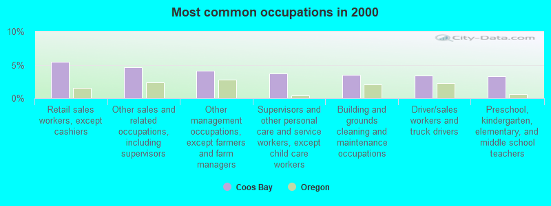
- Retail sales workers, except cashiers (5.5%)
- Other sales and related occupations, including supervisors (4.6%)
- Other management occupations, except farmers and farm managers (4.1%)
- Supervisors and other personal care and service workers, except child care workers (3.7%)
- Building and grounds cleaning and maintenance occupations (3.5%)
- Driver/sales workers and truck drivers (3.4%)
- Preschool, kindergarten, elementary, and middle school teachers (3.3%)
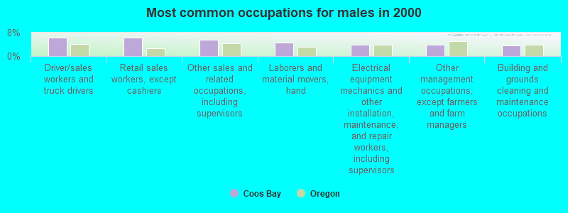
- Driver/sales workers and truck drivers (6.3%)
- Retail sales workers, except cashiers (6.2%)
- Other sales and related occupations, including supervisors (5.5%)
- Laborers and material movers, hand (4.5%)
- Electrical equipment mechanics and other installation, maintenance, and repair workers, including supervisors (3.9%)
- Other management occupations, except farmers and farm managers (3.9%)
- Building and grounds cleaning and maintenance occupations (3.7%)
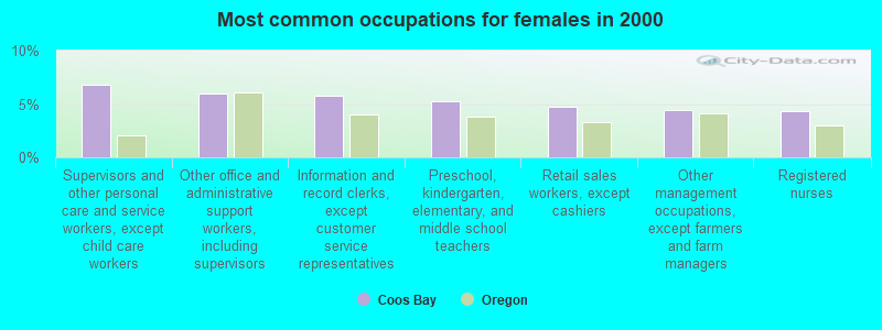
- Supervisors and other personal care and service workers, except child care workers (6.8%)
- Other office and administrative support workers, including supervisors (5.9%)
- Information and record clerks, except customer service representatives (5.7%)
- Preschool, kindergarten, elementary, and middle school teachers (5.3%)
- Retail sales workers, except cashiers (4.7%)
- Other management occupations, except farmers and farm managers (4.4%)
- Registered nurses (4.3%)
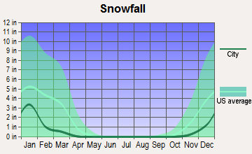
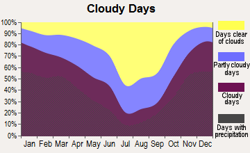
Average climate in Coos Bay, Oregon
Based on data reported by over 4,000 weather stations


|
|

(lower is better)
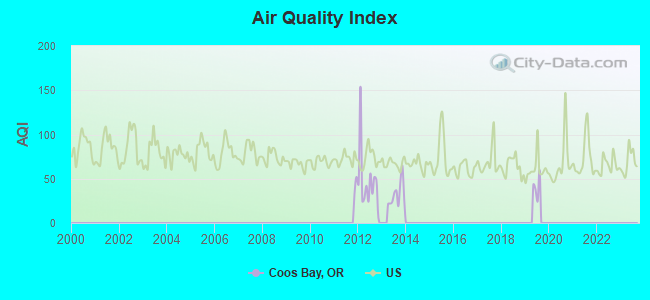
Air Quality Index (AQI) level in 2013 was 32.7. This is significantly better than average.
| City: | 32.7 |
| U.S.: | 72.6 |
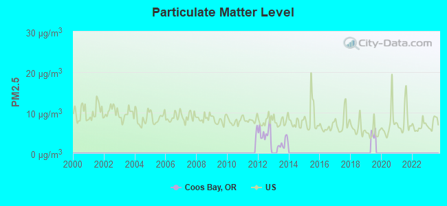
Particulate Matter (PM2.5) [µg/m3] level in 2013 was 2.39. This is significantly better than average. There were 0 monitors within city limits.
| City: | 2.39 |
| U.S.: | 8.11 |
Earthquake activity:
Coos Bay-area historical earthquake activity is significantly above Oregon state average. It is 2394% greater than the overall U.S. average.On 1/31/1922 at 13:17:28, a magnitude 7.6 (7.6 UK, Class: Major, Intensity: VIII - XII) earthquake occurred 197.1 miles away from Coos Bay center
On 8/17/1991 at 22:17:14, a magnitude 7.1 (6.2 MB, 7.1 MS, 7.1 MW, 6.8 ML, Depth: 8.4 mi) earthquake occurred 131.9 miles away from Coos Bay center
On 11/8/1980 at 10:27:34, a magnitude 7.2 (6.2 MB, 7.2 MS, 7.2 MW, 7.0 ML) earthquake occurred 156.8 miles away from Coos Bay center
On 6/15/2005 at 02:50:54, a magnitude 7.2 (7.2 MW, Depth: 9.9 mi) earthquake occurred 168.8 miles away from the city center
On 6/15/2005 at 02:50:54, a magnitude 7.2 (6.1 MB, 7.1 MS, 7.2 MW, 7.1 MW) earthquake occurred 175.0 miles away from Coos Bay center
On 7/13/1991 at 02:50:14, a magnitude 6.9 (6.2 MB, 6.9 MS, 6.8 MW, 6.7 ML, Depth: 6.8 mi, Class: Strong, Intensity: VII - IX) earthquake occurred 112.1 miles away from the city center
Magnitude types: body-wave magnitude (MB), local magnitude (ML), surface-wave magnitude (MS), moment magnitude (MW)
Natural disasters:
The number of natural disasters in Coos County (16) is near the US average (15).Major Disasters (Presidential) Declared: 13
Emergencies Declared: 1
Causes of natural disasters: Floods: 11, Storms: 7, Landslides: 5, Mudslides: 5, Winter Storms: 4, Winds: 3, Fire: 1, Heavy Rain: 1, Hurricane: 1, Snow: 1, Tsunami Wave: 1, Other: 1 (Note: some incidents may be assigned to more than one category).

Hospitals and medical centers in Coos Bay:
- BAY AREA HOSPITAL (Government - Hospital District or Authority, provides emergency services, 1775 THOMPSON ROAD)
- SOUTH COAST HOSPICE (1620 THOMPSON ROAD)
- AVAMERE REHABILITATION OF COOS BAY (2625 KOOS BAY BLVD)
- HEARTHSIDE CARE CENTER (2625 KOOS BAY BLVD)
- LIFE CARE CTR OF COOS BAY (2890 OCEAN BLVD)
- FMC COOS BAY (1971 THOMPSON RD)
- PACIFIC HOME HEALTH AND HOSPICE (455 SOUTH 4TH, SUITE 3)
Heliports located in Coos Bay:
College/University in Coos Bay:
Colleges/universities with over 2000 students nearest to Coos Bay:
- University of Oregon (about 75 miles; Eugene, OR; Full-time enrollment: 23,329)
- Lane Community College (about 75 miles; Eugene, OR; FT enrollment: 6,373)
- Rogue Community College (about 80 miles; Grants Pass, OR; FT enrollment: 3,600)
- Oregon State University (about 96 miles; Corvallis, OR; FT enrollment: 23,206)
- Linn-Benton Community College (about 101 miles; Albany, OR; FT enrollment: 4,511)
- Western Oregon University (about 114 miles; Monmouth, OR; FT enrollment: 5,131)
- Southern Oregon University (about 114 miles; Ashland, OR; FT enrollment: 4,650)
Public high schools in Coos Bay:
- MARSHFIELD SENIOR HIGH SCHOOL (Students: 1,074, Location: 10TH & INGERSOLL, Grades: 8-12)
- DESTINATIONS ACADEMY (Students: 50, Location: 755 S 7TH ST, Grades: 7-12)
- RESOURCE LINK CHARTER SCHOOL (Students: 50, Location: 755 S 7TH ST, Grades: KG-12, Charter school)
Private high school in Coos Bay:
- ALTERNATIVE YOUTH ACTIVITIES (Students: 42, Location: 575 S MAIN ST, Grades: 8-12)
Public elementary/middle schools in Coos Bay:
- BLOSSOM GULCH ELEMENTARY SCHOOL (Students: 508, Location: 333 S 10TH, Grades: KG-3)
- SUNSET SCHOOL (Students: 508, Location: 245 S CAMMANN, Grades: 4-7)
- MADISON ELEMENTARY SCHOOL (Students: 423, Location: 400 MADISON ST, Grades: KG-3)
- MILLICOMA SCHOOL (Location: 260 SECOND AVE, Grades: 4-7)
Private elementary/middle schools in Coos Bay:
Libraries in Coos Bay:
- COOS BAY PUBLIC LIBRARY (Operating income: $961,065; Location: 525 ANDERSON; 119,299 books; 9,336 audio materials; 5,986 video materials; 2 local licensed databases; 27 state licensed databases; 6 other licensed databases; 254 print serial subscriptions; 1 electronic serial subscriptions)
- COOS COUNTY LIBRARY SERVICE DISTRICT (Operating income: $450,257; Location: 1988 NEWMARK, TIOGA 3RD FLOOR; 3,862 books; 405 audio materials; 1,027 video materials; 27 state licensed databases; 6 other licensed databases; 17 print serial subscriptions; 1 electronic serial subscriptions)
Points of interest:
Notable locations in Coos Bay: Southwestern Oregon Community College Poets Eye Outdoor Theatre (A), Coos Bay Wastewater Treatment Plant (B), Coos Bay Empire Sewage Treatment Plant (C), Coos Bay City Dock North (D), John Topits Empire Middle Lake Boat Ramp (E), Empire Boat Ramp (F), Greyhound Station (G), John Topits Empire Lower Lake Boat Ramp (H), Coos Bay City Dock South (I), Eastside Boat Ramp (J), Coos Bay Post Office (K), Southwestern Oregon Community College Library (L), Coos Bay Fire Department Central Station 1 (M), Coos Bay Fire Department Empire Station (N), Coos Bay Municipal Court (O), Coos Bay Public Works (P), KYNG - AM (Q), Coos Bay Public Library (R), Oregon Coast Historical Railways (S), Coos Art Museum (T). Display/hide their locations on the map
Churches in Coos Bay include: Coos Bay Foursquare Church (A), Saint Monicas Catholic Church (B). Display/hide their locations on the map
Cemeteries: Empire Cemetery (1), Independent Order of Odd Fellows Cemetery (2), Ocean View Memorial Gardens (3). Display/hide their locations on the map
Lakes and reservoirs: Upper Empire Lake (A), Empire Lakes (B), Mingus Park Lake (C), Middle Empire Lake (D), Upper Pony Creek Reservoir (E), Lake Merritt (F), Lower Empire Lake (G). Display/hide their locations on the map
Streams, rivers, and creeks: Chickses Creek (A), First Creek (B), Isthmus Slough (C), Mingus Park Creek (D). Display/hide their locations on the map
Parks in Coos Bay include: 10th Street Park (1), Boardwalk Park (2), Eastside Park (3), Taylor/Wasson Park (4), John Topits Park (5), Mingus Park (6). Display/hide their locations on the map
Tourist attractions: Coos Art Museum - Office (235 Anderson Avenue) (1), Coos Art Museum - Education (235 Anderson Avenue) (2), Martin Dodd Amusement (Amusement & Theme Parks; 815 South Broadway) (3), Charleston Tourist Info Center (89814 Cape Arago Highway) (4), Porter's R.V. (971 S. Broadway) (5), Chamber of Commerce - Coos Bay-Charleston-North Bend (50 Central Avenue) (6), Coos Bay City - Tourist Information (50 Central Avenue) (7), Wavecrest Discoveries (Recreational Trips & Guides; PO Box 1795) (8). Display/hide their approximate locations on the map
Hotels: Bayshore Motel (1685 North Bayshore Drive) (1), Motel 6 (1445 North Bayshore Drive) (2), Edgewater Inn (275 East Johnson Avenue) (3), Best Western Holiday Motel (411 North Bayshore Drive) (4), Blackberry Inn (843 Central Avenue) (5), Miller Clarence L (92630 Cape Arago Hwy) (6), Duerksen Motel (155 South Empire Boulevard) (7), Capt Johns Motel (63360 Kingfisher Rd) (8), Plainview Motel & RV Park (91904 Cape Arago Hwy) (9). Display/hide their approximate locations on the map
Birthplace of: Steve Prefontaine - Long-distance runner, Claire Falkenstein - Artist, Gerald Strebendt - Martial artist, Mel Counts - Basketball player, Pat Fitzsimons - Professional golfer, Brian Clem - Politician, Bruce Anderson (American football) - Football player, Lauren Newton (singer) - Opera singer.
Drinking water stations with addresses in Coos Bay and their reported violations in the past:
COOS BAY NORTH BEND WTR BRD (Population served: 38,000, Surface water):Past monitoring violations:MT TERRACE MHP (Population served: 45, Groundwater):
- 2 routine major monitoring violations
- One minor monitoring violation
Past health violations:WATSON RANCH GOLF (Population served: 30, Groundwater):Past monitoring violations:
- MCL, Monthly (TCR) - In SEP-2009, Contaminant: Coliform. Follow-up actions: St Public Notif requested (OCT-14-2009), St Violation/Reminder Notice (OCT-19-2009), St Compliance achieved (FEB-01-2010), St Public Notif received (MAY-03-2010)
- MCL, Monthly (TCR) - In NOV-2008, Contaminant: Coliform. Follow-up actions: St Compliance achieved (DEC-31-2008)
- Failure to Conduct Assessment Monitoring - Between JAN-2013 and DEC-2013, Contaminant: COLIPHAGE
- Failure to Conduct Assessment Monitoring - Between JAN-2013 and DEC-2013, Contaminant: COLIPHAGE
- Follow-up Or Routine LCR Tap M/R - In JAN-01-2011, Contaminant: Lead and Copper Rule. Follow-up actions: St Violation/Reminder Notice (FEB-22-2011), St Compliance achieved (NOV-02-2011)
- Treatment Technique No Certif. Operator - In MAR-19-2010, Contaminant: DBP Stage 1. Follow-up actions: St Violation/Reminder Notice (APR-26-2010), St AO (w/o penalty) issued (NOV-03-2010), St Compliance achieved (OCT-20-2011)
- Monitoring, Repeat Major (TCR) - In JUL-2006, Contaminant: Coliform (TCR). Follow-up actions: St Compliance achieved (2 times from JUL-13-2007 to DEC-06-2007)
- 24 routine major monitoring violations
- 2 minor monitoring violations
- 89 regular monitoring violations
- 5 other older monitoring violations
Past health violations:Past monitoring violations:
- MCL, Monthly (TCR) - Between APR-2010 and JUN-2010, Contaminant: Coliform. Follow-up actions: St Public Notif requested (MAY-18-2010), St Violation/Reminder Notice (MAY-24-2010), St Compliance achieved (JUL-02-2010)
- Monitoring of Treatment (SWTR-Unfilt/GWR) - In JUN-2014, Contaminant: GROUNDWATER RULE
- Monitoring of Treatment (SWTR-Unfilt/GWR) - In MAY-2014, Contaminant: GROUNDWATER RULE
- Monitoring of Treatment (SWTR-Unfilt/GWR) - In APR-2014, Contaminant: GROUNDWATER RULE
- Monitoring of Treatment (SWTR-Unfilt/GWR) - In MAR-2014, Contaminant: GROUNDWATER RULE
- Monitoring of Treatment (SWTR-Unfilt/GWR) - In FEB-2014, Contaminant: GROUNDWATER RULE
- 11 routine major monitoring violations
- 4 minor monitoring violations
- 4 regular monitoring violations
- 25 other older monitoring violations
| This city: | 2.3 people |
| Oregon: | 2.5 people |
| This city: | 57.4% |
| Whole state: | 63.4% |
| This city: | 8.7% |
| Whole state: | 8.0% |
Likely homosexual households (counted as self-reported same-sex unmarried-partner households)
- Lesbian couples: 0.3% of all households
- Gay men: 0.4% of all households
People in group quarters in Coos Bay in 2010:
- 97 people in nursing facilities/skilled-nursing facilities
- 67 people in other noninstitutional facilities
- 27 people in emergency and transitional shelters (with sleeping facilities) for people experiencing homelessness
- 26 people in group homes intended for adults
- 8 people in workers' group living quarters and job corps centers
People in group quarters in Coos Bay in 2000:
- 173 people in college dormitories (includes college quarters off campus)
- 131 people in other group homes
- 98 people in nursing homes
- 32 people in other noninstitutional group quarters
- 12 people in homes for abused, dependent, and neglected children
- 12 people in homes for the mentally retarded
- 8 people in hospitals/wards and hospices for chronically ill
- 8 people in hospices or homes for chronically ill
- 7 people in homes or halfway houses for drug/alcohol abuse
- 6 people in homes for the mentally ill
Banks with branches in Coos Bay (2011 data):
- Sterling Savings Bank: Empire Branch at 150 South Wall Street, branch established on 1955/11/14; Coos Bay Branch at 212 South Fifth Street, branch established on 1969/06/02. Info updated 2012/03/21: Bank assets: $9,207.8 mil, Deposits: $6,454.1 mil, headquarters in Spokane, WA, positive income, Commercial Lending Specialization, 192 total offices, Holding Company: Sterling Financial Corporation
- JPMorgan Chase Bank, National Association: Coos Bay Consumer Finance Branch at 290 South 4th Street, branch established on 1996/01/31. Info updated 2011/11/10: Bank assets: $1,811,678.0 mil, Deposits: $1,190,738.0 mil, headquarters in Columbus, OH, positive income, International Specialization, 5577 total offices, Holding Company: Jpmorgan Chase & Co.
- Wells Fargo Bank, National Association: Coos Bay Branch at 200 North Broadway, branch established on 1900/01/01. Info updated 2011/04/05: Bank assets: $1,161,490.0 mil, Deposits: $905,653.0 mil, headquarters in Sioux Falls, SD, positive income, 6395 total offices, Holding Company: Wells Fargo & Company
- Umpqua Bank: Coos Bay Branch at 700 South Broadway, Suite 100, branch established on 1919/08/29. Info updated 2011/09/02: Bank assets: $11,556.7 mil, Deposits: $9,325.3 mil, headquarters in Roseburg, OR, positive income, Commercial Lending Specialization, 193 total offices, Holding Company: Umpqua Holdings Corporation
- U.S. Bank National Association: Coos Bay Branch at 400 West Anderson, branch established on 1956/01/23. Info updated 2012/01/30: Bank assets: $330,470.8 mil, Deposits: $236,091.5 mil, headquarters in Cincinnati, OH, positive income, 3121 total offices, Holding Company: U.S. Bancorp
- Oregon Pacific Banking Company dba Oregon Pacific Bank: Coos Bay Branch Oregon Pacific Bk Co at 915 S. First St., branch established on 2002/06/03. Info updated 2006/11/03: Bank assets: $174.0 mil, Deposits: $143.1 mil, headquarters in Florence, OR, positive income, Commercial Lending Specialization, 5 total offices, Holding Company: Oregon Pacific Bancorp
For population 15 years and over in Coos Bay:
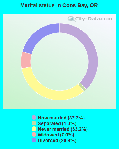
- Never married: 33.2%
- Now married: 37.7%
- Separated: 1.3%
- Widowed: 7.0%
- Divorced: 20.8%
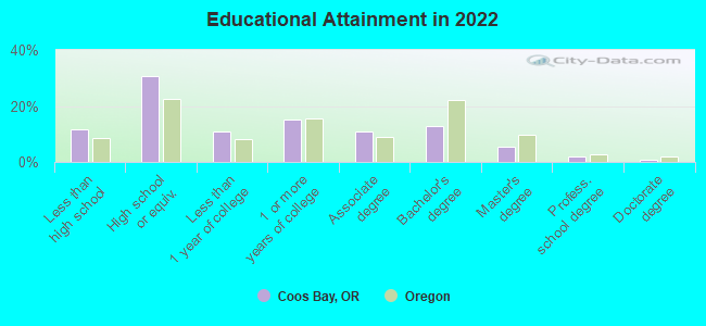
For population 25 years and over in Coos Bay:
- High school or higher: 88.0%
- Bachelor's degree or higher: 20.2%
- Graduate or professional degree: 7.4%
- Unemployed: 9.4%
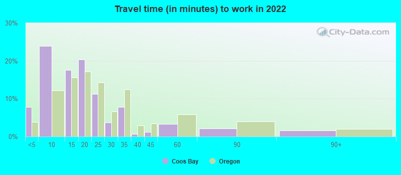
- Mean travel time to work (commute): 13.6 minutes
| Here: | 10.5 |
| Oregon average: | 11.6 |
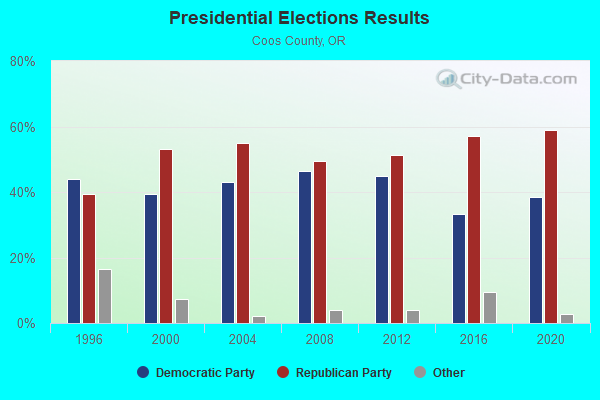
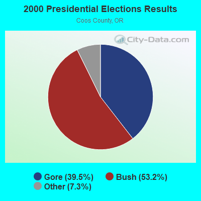
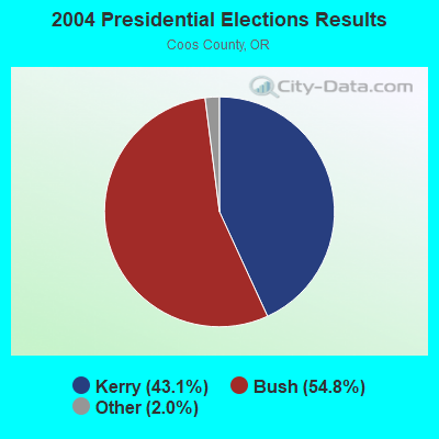
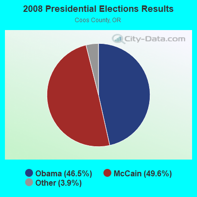
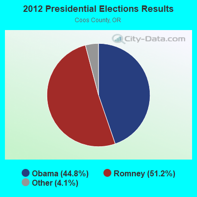
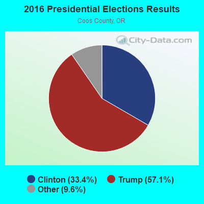
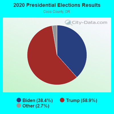
Graphs represent county-level data. Detailed 2008 Election Results
Religion statistics for Coos Bay, OR (based on Coos County data)
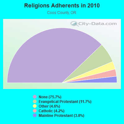
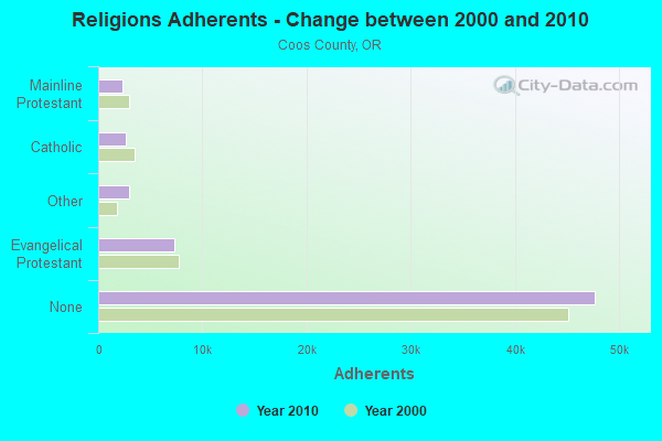
| Religion | Adherents | Congregations |
|---|---|---|
| Evangelical Protestant | 7,351 | 63 |
| Other | 2,931 | 15 |
| Catholic | 2,658 | 5 |
| Mainline Protestant | 2,380 | 18 |
| None | 47,723 | - |
Food Environment Statistics:
| Coos County: | 3.47 / 10,000 pop. |
| State: | 2.03 / 10,000 pop. |
| Coos County: | 0.63 / 10,000 pop. |
| State: | 0.33 / 10,000 pop. |
| Coos County: | 2.05 / 10,000 pop. |
| State: | 2.01 / 10,000 pop. |
| Coos County: | 1.58 / 10,000 pop. |
| Oregon: | 1.69 / 10,000 pop. |
| Coos County: | 11.35 / 10,000 pop. |
| Oregon: | 9.93 / 10,000 pop. |
| Coos County: | 10.5% |
| Oregon: | 7.4% |
| This county: | 29.7% |
| Oregon: | 25.6% |
| This county: | 17.1% |
| Oregon: | 14.2% |
Health and Nutrition:
| Coos Bay: | 50.0% |
| State: | 49.6% |
| Coos Bay: | 46.4% |
| State: | 46.8% |
| Coos Bay: | 28.6 |
| Oregon: | 28.5 |
| Coos Bay: | 21.8% |
| Oregon: | 21.2% |
| Here: | 10.3% |
| State: | 10.1% |
| Coos Bay: | 6.9 |
| State: | 6.8 |
| This city: | 34.6% |
| State: | 33.3% |
| Coos Bay: | 55.4% |
| State: | 56.5% |
| Coos Bay: | 76.7% |
| State: | 78.7% |
More about Health and Nutrition of Coos Bay, OR Residents
| Local government employment and payroll (March 2022) | |||||
| Function | Full-time employees | Monthly full-time payroll | Average yearly full-time wage | Part-time employees | Monthly part-time payroll |
|---|---|---|---|---|---|
| Police Protection - Officers | 23 | $183,204 | $95,585 | 1 | $1,257 |
| Other and Unallocable | 19 | $108,799 | $68,715 | 0 | $0 |
| Police - Other | 17 | $116,893 | $82,513 | 0 | $0 |
| Sewerage | 16 | $78,005 | $58,504 | 0 | $0 |
| Firefighters | 15 | $114,159 | $91,327 | 0 | $0 |
| Local Libraries | 12 | $54,686 | $54,686 | 5 | $10,210 |
| Other Government Administration | 6 | $48,178 | $96,356 | 0 | $0 |
| Streets and Highways | 5 | $25,551 | $61,322 | 0 | $0 |
| Parks and Recreation | 3 | $15,825 | $63,300 | 0 | $0 |
| Financial Administration | 3 | $18,633 | $74,532 | 0 | $0 |
| Fire - Other | 1 | $10,697 | $128,364 | 0 | $0 |
| Judicial and Legal | 1 | $8,798 | $105,576 | 0 | $0 |
| Totals for Government | 121 | $783,428 | $77,695 | 6 | $11,467 |
Coos Bay government finances - Expenditure in 2021 (per resident):
- Construction - Sewerage: $17,375,000 ($1096.91)
General - Other: $5,857,000 ($369.76)
Parks and Recreation: $54,000 ($3.41)
- Current Operations - Police Protection: $5,611,000 ($354.23)
Sewerage: $4,530,000 ($285.98)
Local Fire Protection: $2,968,000 ($187.37)
Libraries: $1,942,000 ($122.60)
General - Other: $1,313,000 ($82.89)
Central Staff Services: $1,296,000 ($81.82)
Regular Highways: $1,167,000 ($73.67)
Parks and Recreation: $547,000 ($34.53)
Protective Inspection and Regulation - Other: $409,000 ($25.82)
Financial Administration: $245,000 ($15.47)
Judicial and Legal Services: $67,000 ($4.23)
- Other Capital Outlay - Sewerage: $425,000 ($26.83)
General - Other: $354,000 ($22.35)
Parks and Recreation: $73,000 ($4.61)
Regular Highways: $64,000 ($4.04)
- Total Salaries and Wages: $8,969,000 ($566.22)
- Water Utilities - Interest on Debt: $714,000 ($45.08)
Coos Bay government finances - Revenue in 2021 (per resident):
- Charges - Sewerage: $6,112,000 ($385.86)
Other: $360,000 ($22.73)
- Federal Intergovernmental - Other: $141,000 ($8.90)
- Local Intergovernmental - General Local Government Support: $1,434,000 ($90.53)
Sewerage: $464,000 ($29.29)
Other: $283,000 ($17.87)
- Miscellaneous - Sale of Property: $672,000 ($42.42)
Interest Earnings: $397,000 ($25.06)
General Revenue - Other: $228,000 ($14.39)
Rents: $130,000 ($8.21)
Fines and Forfeits: $103,000 ($6.50)
Donations From Private Sources: $36,000 ($2.27)
Special Assessments: $2,000 ($0.13)
- State Intergovernmental - General Local Government Support: $2,270,000 ($143.31)
Other: $217,000 ($13.70)
- Tax - Property: $9,014,000 ($569.07)
Public Utilities Sales: $2,637,000 ($166.48)
Other Selective Sales: $789,000 ($49.81)
Other License: $492,000 ($31.06)
Occupation and Business License - Other: $119,000 ($7.51)
Alcoholic Beverage License: $2,000 ($0.13)
Amusements License: $2,000 ($0.13)
Coos Bay government finances - Debt in 2021 (per resident):
- Long Term Debt - Beginning Outstanding - Unspecified Public Purpose: $13,365,000 ($843.75)
Outstanding Unspecified Public Purpose: $9,285,000 ($586.17)
Retired Unspecified Public Purpose: $4,080,000 ($257.58)
Coos Bay government finances - Cash and Securities in 2021 (per resident):
- Other Funds - Cash and Securities: $27,425,000 ($1731.38)
- Sinking Funds - Cash and Securities: $7,605,000 ($480.11)
| Businesses in Coos Bay, OR | ||||
| Name | Count | Name | Count | |
|---|---|---|---|---|
| 7-Eleven | 2 | McDonald's | 2 | |
| AT&T | 1 | Motel 6 | 1 | |
| Arby's | 1 | Nike | 1 | |
| Best Western | 1 | Sprint Nextel | 1 | |
| Burger King | 2 | Staples | 1 | |
| Curves | 1 | Subway | 1 | |
| Dairy Queen | 2 | Super 8 | 1 | |
| Decora Cabinetry | 1 | Taco Bell | 1 | |
| Domino's Pizza | 1 | Toyota | 1 | |
| FedEx | 3 | True Value | 1 | |
| Ford | 1 | U-Haul | 2 | |
| H&R Block | 2 | U.S. Cellular | 1 | |
| Honda | 1 | UPS | 2 | |
| Kmart | 1 | Vons | 2 | |
| Kroger | 2 | Walmart | 1 | |
| Lane Furniture | 1 | Wendy's | 1 | |
| MasterBrand Cabinets | 10 | |||
Strongest AM radio stations in Coos Bay:
- KMHS (1420 AM; 1 kW; COOS BAY, OR; Owner: COOS BAY SCHOOL DISTRICT 9)
- KDUN (1030 AM; 50 kW; REEDSPORT, OR; Owner: PAMPLIN BROADCASTING-OREGON, INC.)
- KHSN (1230 AM; 1 kW; COOS BAY, OR; Owner: NEW NORTHWEST BROADCASTERS LLC)
- KBBR (1340 AM; 1 kW; NORTH BEND, OR; Owner: NEW NORTHWEST BROADCASTERS, LLC)
- KWRO (630 AM; 5 kW; COQUILLE, OR; Owner: COQUILLE RIVER BROADCASTERS, INC.)
- KGRV (700 AM; 25 kW; WINSTON, OR; Owner: PACIFIC CASCADE COMMUNICATIONS CORP.)
- KPNW (1120 AM; 50 kW; EUGENE, OR; Owner: CAPSTAR TX LIMITED PARTNERSHIP)
- KPOJ (620 AM; 50 kW; PORTLAND, OR; Owner: CITICASTERS LICENSES, L.P.)
- KZTU (660 AM; 10 kW; JUNCTION CITY, OR; Owner: PAMPLIN BROADCASTING-OREGON, INC.)
- KXL (750 AM; 50 kW; PORTLAND, OR; Owner: ROSE CITY RADIO CORPORATION)
- KPAM (860 AM; 50 kW; TROUTDALE, OR; Owner: PAMPLIN BROADCASTING-OREGON, INC.)
- KTBR (950 AM; 3 kW; ROSEBURG, OR; Owner: JPR FOUNDATION INC.)
- KEX (1190 AM; 50 kW; PORTLAND, OR; Owner: CITICASTERS LICENSES, L.P.)
Strongest FM radio stations in Coos Bay:
- K210DM (89.9 FM; COOS BAY, OR; Owner: CALVARY CHAPEL OF TWIN FALLS, INC.)
- KYSJ (105.9 FM; COOS BAY, OR; Owner: LIGHTHOUSE RADIO GROUP, A OREGON P/S)
- KDCQ (93.5 FM; COOS BAY, OR; Owner: BAY CITIES BUILDING COMPANY, INC.)
- KOOS (94.9 FM; NORTH BEND, OR; Owner: NEW NORTHWEST BROADCASTERS, LLC)
- KSBA (88.5 FM; COOS BAY, OR; Owner: OREGON ST. BOARD OF HIGHER EDUCATION)
- K219CK (91.7 FM; COOS BAY, OR; Owner: FAMILY STATIONS, INC.)
- KSHR-FM (97.3 FM; COQUILLE, OR; Owner: COQUILLE RIVER BROADCASTERS, INC.)
- K299AA (107.7 FM; NORTH BEND COOS BAY, OR; Owner: NEW NORTHWEST BROADCASTERS, LLC)
- KACW (107.3 FM; NORTH BEND, OR; Owner: NEW NORTHWEST BROADCASTERS, LLC)
- K217CW (91.3 FM; COOS BAY, OR; Owner: PENSACOLA CHRISTIAN COLLEGE, INC.)
- KLOV-FM (89.3 FM; WINCHESTER, OR; Owner: EDUCATIONAL MEDIA FOUNDATION)
- KOOZ (94.1 FM; MYRTLE POINT, OR; Owner: JPR FOUNDATION INC.)
- KBDN (96.5 FM; BANDON, OR; Owner: COQUILLE RIVER BROADCASTERS, INC.)
- KRSB-FM (103.1 FM; ROSEBURG, OR; Owner: BROOKE COMMUNICATIONS, INC.)
- KAVJ (101.1 FM; SUTHERLIN, OR; Owner: BROOKE COMMUNICATIONS, INC.)
- K261BF (100.1 FM; BLACK BUTTE, ETC., OR; Owner: FAMILY STATIONS, INC.)
- K205DM (88.9 FM; GLIDE, OR; Owner: CALVARY CHAPEL OF TWIN FALLS, INC.)
- KWVZ (91.5 FM; FLORENCE, OR; Owner: OREGON STATE BOARD OF HIGHER ED.)
- KSOR (90.1 FM; ASHLAND, OR; Owner: OREGON STATE BOARD OF HIGHER EDUC.)
- K222AF (92.3 FM; AZALEA, OR; Owner: FAMILY LIFE BROADCASTING, INC.)
TV broadcast stations around Coos Bay:
- K30BN (Channel 30; COOS BAY, OR; Owner: CALIFORNIA OREGON BROADCASTING, INC.)
- K44FH (Channel 44; COOS BAY, OR; Owner: BETTER LIFE TELEVISION)
- K63DO (Channel 63; COOS BAY, OR; Owner: CALIFORNIA OREGON BROADCASTING, INC.)
- K33AO (Channel 33; COOS BAY, OR; Owner: TRINITY BROADCASTING NETWORK)
- K49DM (Channel 49; COOS BAY, OR; Owner: WATCHTV, INC.)
- KCBY-TV (Channel 11; COOS BAY, OR; Owner: FISHER BROADCASTING - OREGON TV, L.L.C.)
- KMTZ (Channel 23; COOS BAY, OR; Owner: ACKERLEY MEDIA GROUP, INC.)
- K27CL (Channel 27; COOS BAY, OR; Owner: KEZI, INC.)
- K46AS (Channel 46; COOS BAY, OR; Owner: ACKERLEY MEDIA GROUP, INC.)
- K13JQ (Channel 13; NORTH BEND, EMPIRE, OR; Owner: CALIFORNIA OREGON BROADCASTING, INC.)
- K36BX (Channel 36; COOS BAY, OR; Owner: CALIFORNIA OREGON BROADCASTING, INC.)
- K17AA (Channel 17; COOS BAY, ETC., OR; Owner: OREGON PUBLIC BROADCASTING)
- National Bridge Inventory (NBI) Statistics
- 12Number of bridges
- 302ft / 92.4mTotal length
- $6,558,000Total costs
- 52,735Total average daily traffic
- 6,190Total average daily truck traffic
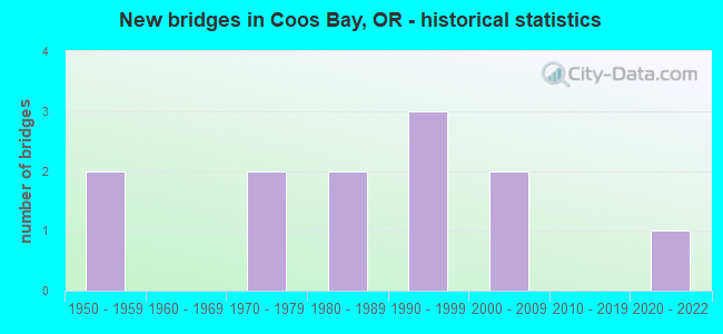
- New bridges - historical statistics
- 21950-1959
- 21970-1979
- 21980-1989
- 31990-1999
- 22000-2009
- 12020-2022
FCC Registered Antenna Towers: 151 (See the full list of FCC Registered Antenna Towers)
FCC Registered Commercial Land Mobile Towers: 2 (See the full list of FCC Registered Commercial Land Mobile Towers in Coos Bay, OR)
FCC Registered Private Land Mobile Towers: 6 (See the full list of FCC Registered Private Land Mobile Towers)
FCC Registered Broadcast Land Mobile Towers: 25 (See the full list of FCC Registered Broadcast Land Mobile Towers)
FCC Registered Microwave Towers: 65 (See the full list of FCC Registered Microwave Towers in this town)
FCC Registered Paging Towers: 9 (See the full list of FCC Registered Paging Towers)
FCC Registered Maritime Coast & Aviation Ground Towers: 11 (See the full list of FCC Registered Maritime Coast & Aviation Ground Towers)
FCC Registered Amateur Radio Licenses: 335 (See the full list of FCC Registered Amateur Radio Licenses in Coos Bay)
FAA Registered Aircraft: 30 (See the full list of FAA Registered Aircraft in Coos Bay)
2002 - 2018 National Fire Incident Reporting System (NFIRS) incidents
- Fire incident types reported to NFIRS in Coos Bay, OR
- 39943.2%Structure Fires
- 32435.1%Outside Fires
- 15416.7%Mobile Property/Vehicle Fires
- 475.1%Other
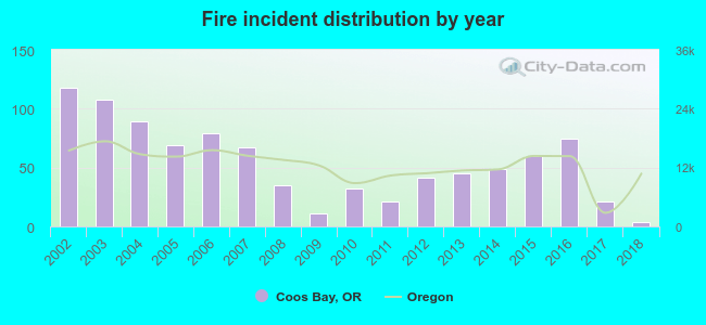 According to the data from the years 2002 - 2018 the average number of fires per year is 54. The highest number of fire incidents - 118 took place in 2002, and the least - 4 in 2018. The data has a decreasing trend.
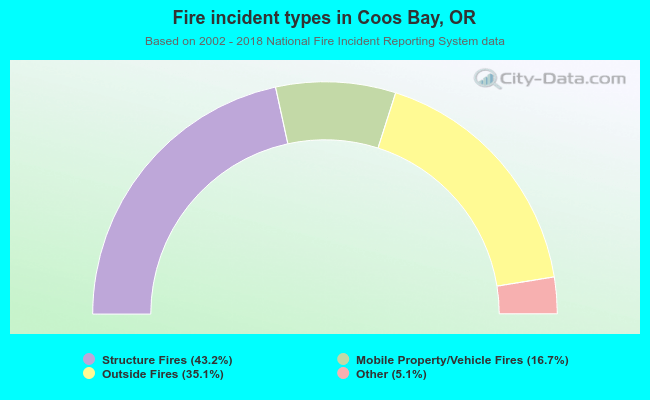 When looking into fire subcategories, the most reports belonged to: Structure Fires (43.2%), and Outside Fires (35.1%).
Fire-safe hotels and motels in Coos Bay, Oregon:
- Red Lion Hotel Coos Bay, 1313 N Bayshore Dr, Coos Bay, Oregon 97420 , Phone: (541) 267-4141, Fax: (541) 267-2884
- Best Western Holiday Motel, 411 N Bayshore Dr, Coos Bay, Oregon 97420 , Phone: (800) 228-8655, Fax: (541) 269-5381
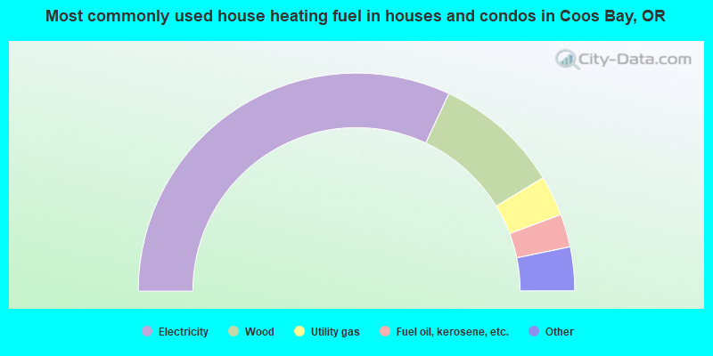
- 64.0%Electricity
- 18.7%Wood
- 6.0%Utility gas
- 4.9%Fuel oil, kerosene, etc.
- 3.5%Other fuel
- 1.6%Bottled, tank, or LP gas
- 0.8%Solar energy
- 0.5%No fuel used
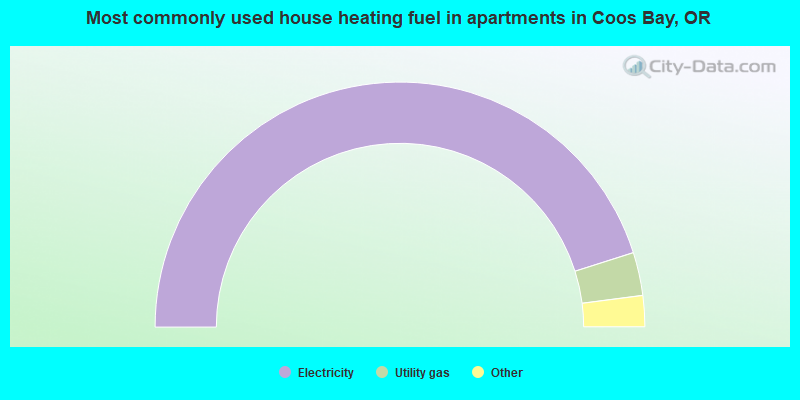
- 90.2%Electricity
- 5.7%Utility gas
- 3.0%Wood
- 0.5%Bottled, tank, or LP gas
- 0.3%Other fuel
- 0.2%No fuel used
Coos Bay compared to Oregon state average:
- Median house value below state average.
- Black race population percentage below state average.
- Median age above state average.
- Foreign-born population percentage below state average.
- Length of stay since moving in significantly above state average.
Coos Bay on our top lists:
- #87 on the list of "Top 101 cities with largest percentage of males in occupations: personal care and service occupations (population 5,000+)"
- #98 on the list of "Top 101 cities with the largest percentage of people in hospices or homes for chronically ill (population 1,000+)"
- #10 on the list of "Top 101 counties with the highest number of deaths per 1000 residents 2007-2013 (pop. 50,000+)"
- #23 on the list of "Top 101 counties with highest percentage of residents voting for 3rd party candidates in the 2012 Presidential Election (pop. 50,000+)"
- #101 on the list of "Top 101 counties with the smallest number of children under 18 without health insurance coverage in 2000 (pop. 50,000+)"

|
|
Total of 21 patent applications in 2008-2024.