Danville, West Virginia
Submit your own pictures of this town and show them to the world
(27.9% for White Non-Hispanic residents, 100.0% for Black residents)
Detailed information about poverty and poor residents in Danville, WV
Full-time law enforcement employees in 2020, including police officers: 2 (2 officers - 2 male; 0 female).
| Officers per 1,000 residents here: | 3.37 |
| West Virginia average: | 2.32 |
 Recent articles from our blog. Our writers, many of them Ph.D. graduates or candidates, create easy-to-read articles on a wide variety of topics.
| Here: | 4.5% |
| West Virginia: | 4.0% |
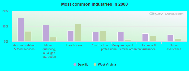
- Accommodation & food services (15.5%)
- Mining, quarrying, oil & gas extraction (11.1%)
- Health care (7.1%)
- Construction (6.2%)
- Religious, grantmaking, civic, professional, similar organizations (6.2%)
- Finance & insurance (5.3%)
- Social assistance (4.4%)
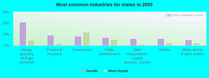
- Mining, quarrying, oil & gas extraction (20.8%)
- Finance & insurance (9.4%)
- Construction (8.3%)
- Public administration (7.3%)
- Other transportation, support activities, couriers (6.2%)
- Utilities (6.2%)
- Motor vehicle & parts dealers (5.2%)

- Accommodation & food services (23.8%)
- Health care (12.3%)
- Religious, grantmaking, civic, professional, similar organizations (10.8%)
- Social assistance (7.7%)
- Other direct selling establishments (6.9%)
- Professional, scientific, technical services (6.9%)
- Gasoline stations (6.2%)
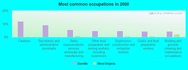
- Cashiers (11.9%)
- Secretaries and administrative assistants (9.3%)
- Sales representatives, services, wholesale and manufacturing (5.8%)
- Other food preparation and serving workers, including supervisors (4.9%)
- Supervisors, construction and extraction workers (4.9%)
- Cooks and food preparation workers (4.4%)
- Building and grounds cleaning and maintenance occupations (4.4%)
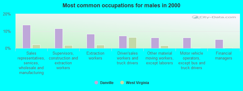
- Sales representatives, services, wholesale and manufacturing (13.5%)
- Supervisors, construction and extraction workers (11.5%)
- Extraction workers (8.3%)
- Driver/sales workers and truck drivers (7.3%)
- Other material moving workers, except laborers (6.2%)
- Motor vehicle operators, except bus and truck drivers (6.2%)
- Financial managers (5.2%)
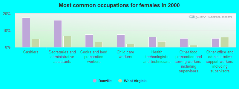
- Cashiers (17.7%)
- Secretaries and administrative assistants (16.2%)
- Cooks and food preparation workers (7.7%)
- Child care workers (7.7%)
- Health technologists and technicians (6.2%)
- Other food preparation and serving workers, including supervisors (5.4%)
- Other office and administrative support workers, including supervisors (5.4%)
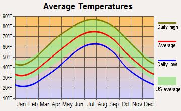
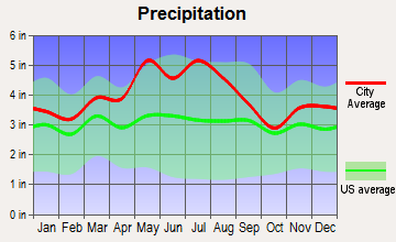
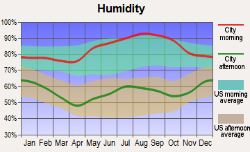
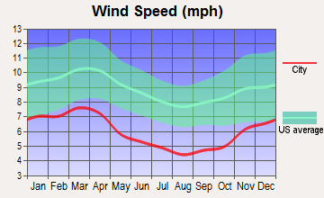
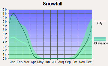
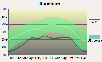
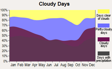
Average climate in Danville, West Virginia
Based on data reported by over 4,000 weather stations
(lower is better)
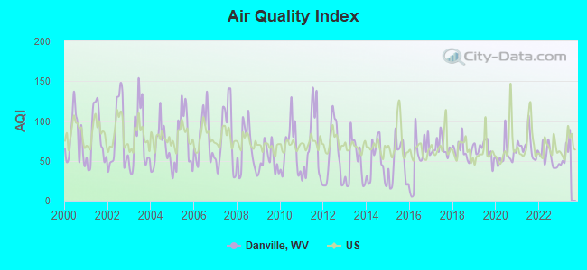
Air Quality Index (AQI) level in 2022 was 54.5. This is better than average.
| City: | 54.5 |
| U.S.: | 72.6 |
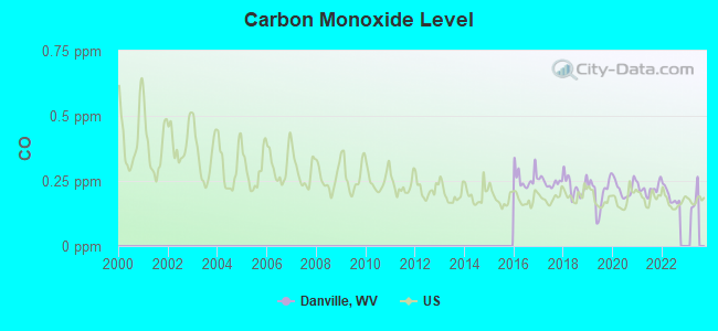
Carbon Monoxide (CO) [ppm] level in 2022 was 0.193. This is better than average. Closest monitor was 21.8 miles away from the city center.
| City: | 0.193 |
| U.S.: | 0.251 |
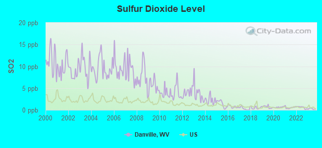
Sulfur Dioxide (SO2) [ppb] level in 2022 was 0.596. This is significantly better than average. Closest monitor was 19.4 miles away from the city center.
| City: | 0.596 |
| U.S.: | 1.515 |
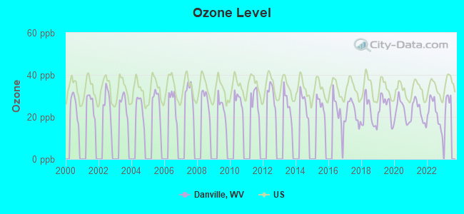
Ozone [ppb] level in 2022 was 21.7. This is significantly better than average. Closest monitor was 21.7 miles away from the city center.
| City: | 21.7 |
| U.S.: | 33.3 |
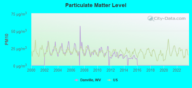
Particulate Matter (PM10) [µg/m3] level in 2015 was 11.1. This is significantly better than average. Closest monitor was 21.4 miles away from the city center.
| City: | 11.1 |
| U.S.: | 19.2 |
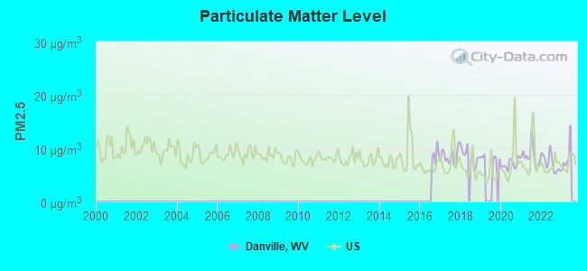
Particulate Matter (PM2.5) [µg/m3] level in 2022 was 7.21. This is about average. Closest monitor was 21.4 miles away from the city center.
| City: | 7.21 |
| U.S.: | 8.11 |
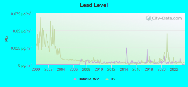
Lead (Pb) [µg/m3] level in 2022 was 0.00387. This is significantly better than average. Closest monitor was 18.7 miles away from the city center.
| City: | 0.00387 |
| U.S.: | 0.00931 |
Tornado activity:
Danville-area historical tornado activity is below West Virginia state average. It is 77% smaller than the overall U.S. average.
On 4/23/1968, a category F5 (max. wind speeds 261-318 mph) tornado 55.0 miles away from the Danville town center killed 7 people and injured 93 people and caused between $500,000 and $5,000,000 in damages.
On 4/8/1965, a category F3 (max. wind speeds 158-206 mph) tornado 41.1 miles away from the town center injured 3 people and caused between $50,000 and $500,000 in damages.
Earthquake activity:
Danville-area historical earthquake activity is significantly above West Virginia state average. It is 1% smaller than the overall U.S. average.On 8/23/2011 at 17:51:04, a magnitude 5.8 (5.8 MW, Depth: 3.7 mi, Class: Moderate, Intensity: VI - VII) earthquake occurred 212.9 miles away from Danville center
On 7/27/1980 at 18:52:21, a magnitude 5.2 (5.1 MB, 4.7 MS, 5.0 UK, 5.2 UK) earthquake occurred 115.0 miles away from the city center
On 8/9/2020 at 12:07:37, a magnitude 5.1 (5.1 MW, Depth: 4.7 mi) earthquake occurred 118.1 miles away from Danville center
On 9/7/1988 at 02:28:09, a magnitude 4.6 (4.5 MB, 4.6 LG, Class: Light, Intensity: IV - V) earthquake occurred 111.2 miles away from the city center
On 11/2/2006 at 17:53:02, a magnitude 4.3 (4.3 MB, Depth: 0.6 mi) earthquake occurred 60.9 miles away from the city center
On 11/23/2006 at 10:42:57, a magnitude 4.3 (4.3 MB) earthquake occurred 64.1 miles away from the city center
Magnitude types: regional Lg-wave magnitude (LG), body-wave magnitude (MB), surface-wave magnitude (MS), moment magnitude (MW)
Natural disasters:
The number of natural disasters in Boone County (23) is greater than the US average (15).Major Disasters (Presidential) Declared: 17
Emergencies Declared: 5
Causes of natural disasters: Floods: 11, Storms: 9, Landslides: 7, Winter Storms: 4, Hurricanes: 3, Mudslides: 3, Blizzard: 1, Fire: 1, Heavy Rain: 1, Snowfall: 1, Snowstorm: 1, Wind: 1, Other: 2 (Note: some incidents may be assigned to more than one category).

Hospitals and medical centers in Danville:
Colleges/universities with over 2000 students nearest to Danville:
- West Virginia State University (about 22 miles; Institute, WV; Full-time enrollment: 2,133)
- New River Community and Technical College (about 39 miles; Beckley, WV; FT enrollment: 2,234)
- Marshall University (about 41 miles; Huntington, WV; FT enrollment: 11,450)
- Ashland Community and Technical College (about 52 miles; Ashland, KY; FT enrollment: 2,482)
- Big Sandy Community and Technical College (about 59 miles; Prestonsburg, KY; FT enrollment: 2,660)
- Concord University (about 65 miles; Athens, WV; FT enrollment: 2,698)
- Shawnee State University (about 78 miles; Portsmouth, OH; FT enrollment: 4,160)
Public high school in Danville:
Public elementary/middle school in Danville:
- RAMAGE ELEMENTARY (Students: 268, Location: 15908 SPRUCE RIVER RD, Grades: PK-5)
Points of interest:
Notable locations in Danville: Boone County Ambulance Authority Medic Station 20 (A), West Virginia Division of Forestry Boone County Field Office (B), Danville Volunteer Fire Department (C). Display/hide their locations on the map
Streams, rivers, and creeks: Price Branch (A), Turtle Creek (B). Display/hide their locations on the map
Drinking water stations with addresses in Danville and their reported violations in the past:
LITTLE COAL RIVER CAMPGROUND (Population served: 25, Groundwater):Past monitoring violations:
- Monitoring of Treatment (SWTR-Unfilt/GWR) - In OCT-2013, Contaminant: GROUNDWATER RULE. Follow-up actions: St Compliance achieved (NOV-30-2013), St Public Notif requested (DEC-07-2013), St Formal NOV issued (DEC-07-2013)
- Monitoring of Treatment (SWTR-Unfilt/GWR) - In MAY-2012, Contaminant: GROUNDWATER RULE. Follow-up actions: St Compliance achieved (JUN-30-2012), St Public Notif requested (JUL-10-2012), St Formal NOV issued (JUL-10-2012), St Public Notif received (APR-10-2013)
- Monitoring of Treatment (SWTR-Unfilt/GWR) - In APR-2011, Contaminant: GROUNDWATER RULE. Follow-up actions: St Compliance achieved (MAY-01-2011), St Public Notif requested (JUN-08-2011), St Formal NOV issued (JUN-08-2011), St Public Notif received (NOV-01-2011)
- Monitoring of Treatment (SWTR-Unfilt/GWR) - In OCT-2010, Contaminant: GROUNDWATER RULE. Follow-up actions: St Public Notif requested (DEC-23-2010), St Formal NOV issued (DEC-23-2010), St Public Notif received (OCT-07-2011), St Compliance achieved (OCT-31-2011)
- 6 routine major monitoring violations
- 4 regular monitoring violations
| This town: | 2.0 people |
| West Virginia: | 2.4 people |
| This town: | 49.5% |
| Whole state: | 65.8% |
| This town: | 7.6% |
| Whole state: | 6.6% |
No gay or lesbian households reported
Banks with branches in Danville (2011 data):
- Branch Banking and Trust Company: Danville Wv Main Branch at 1447 Smoot Avenue, branch established on 1902/03/17. Info updated 2010/03/29: Bank assets: $168,867.6 mil, Deposits: $127,549.5 mil, headquarters in Winston Salem, NC, positive income, Commercial Lending Specialization, 1793 total offices, Holding Company: Bb&T Corporation
- United Bank: Danville Branch at 1661 Smoot Ave, branch established on 1934/01/01. Info updated 2007/09/20: Bank assets: $3,625.4 mil, Deposits: $3,023.8 mil, headquarters in Parkersburg, WV, positive income, Commercial Lending Specialization, 56 total offices, Holding Company: United Bankshares, Inc.
| Here: | 8.5 |
| West Virginia average: | 11.1 |
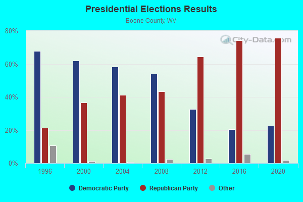
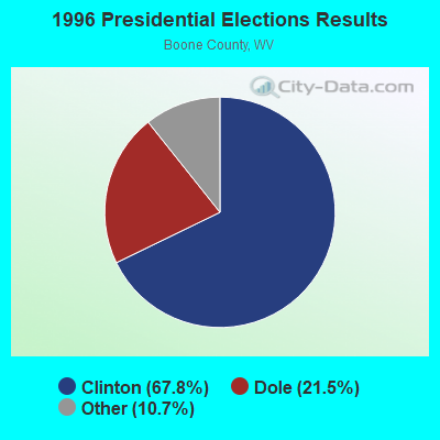
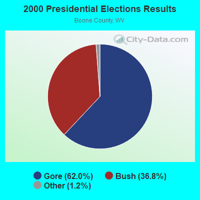
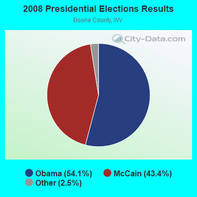
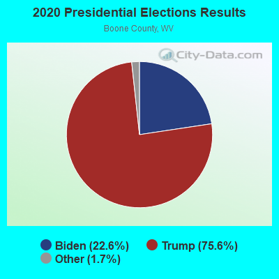
Graphs represent county-level data. Detailed 2008 Election Results
Religion statistics for Danville, WV (based on Boone County data)
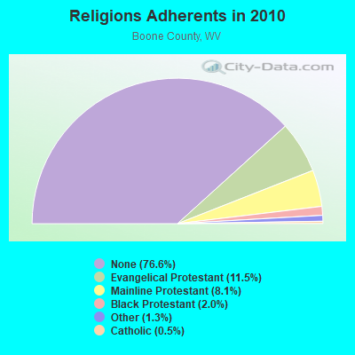
| Religion | Adherents | Congregations |
|---|---|---|
| Evangelical Protestant | 2,837 | 43 |
| Mainline Protestant | 1,993 | 17 |
| Black Protestant | 487 | 3 |
| Other | 310 | 3 |
| Catholic | 132 | 2 |
| None | 18,870 | - |
Food Environment Statistics:
| Boone County: | 4.76 / 10,000 pop. |
| West Virginia: | 2.41 / 10,000 pop. |
| This county: | 2.38 / 10,000 pop. |
| West Virginia: | 1.09 / 10,000 pop. |
| Boone County: | 6.35 / 10,000 pop. |
| State: | 5.38 / 10,000 pop. |
| Boone County: | 3.57 / 10,000 pop. |
| State: | 6.22 / 10,000 pop. |
| Here: | 15.9% |
| West Virginia: | 12.2% |
| Boone County: | 33.6% |
| West Virginia: | 31.1% |
| Boone County: | 15.9% |
| State: | 13.1% |
| Local government employment and payroll (March 2022) | |||||
| Function | Full-time employees | Monthly full-time payroll | Average yearly full-time wage | Part-time employees | Monthly part-time payroll |
|---|---|---|---|---|---|
| Streets and Highways | 4 | $14,446 | $43,338 | 0 | $0 |
| Police Protection - Officers | 2 | $8,138 | $48,828 | 4 | $4,343 |
| Financial Administration | 1 | $4,609 | $55,308 | 0 | $0 |
| Totals for Government | 7 | $27,193 | $46,617 | 4 | $4,343 |
Danville government finances - Expenditure in 2017 (per resident):
- Current Operations - Financial Administration: $212,000 ($325.15)
Police Protection: $107,000 ($164.11)
Central Staff Services: $106,000 ($162.58)
Regular Highways: $91,000 ($139.57)
Parks and Recreation: $3,000 ($4.60)
Judicial and Legal Services: $3,000 ($4.60)
- Total Salaries and Wages: $233,000 ($357.36)
Danville government finances - Revenue in 2017 (per resident):
- Charges - Other: $77,000 ($118.10)
- Miscellaneous - Donations From Private Sources: $20,000 ($30.67)
Fines and Forfeits: $5,000 ($7.67)
General Revenue - Other: $5,000 ($7.67)
Interest Earnings: $1,000 ($1.53)
- State Intergovernmental - Other: $6,000 ($9.20)
General Local Government Support: $1,000 ($1.53)
- Tax - Occupation and Business License - Other: $183,000 ($280.67)
Property: $145,000 ($222.39)
Alcoholic Beverage Sales: $37,000 ($56.75)
Other: $24,000 ($36.81)
Public Utilities Sales: $23,000 ($35.28)
Other License: $4,000 ($6.13)
Danville government finances - Cash and Securities in 2017 (per resident):
- Other Funds - Cash and Securities: $172,000 ($263.80)
| Businesses in Danville, WV | ||||
| Name | Count | Name | Count | |
|---|---|---|---|---|
| Advance Auto Parts | 1 | Rite Aid | 1 | |
| Ford | 1 | Subway | 1 | |
| H&R Block | 1 | True Value | 1 | |
| KFC | 1 | U-Haul | 1 | |
| Kroger | 1 | UPS | 1 | |
| Pizza Hut | 1 | Wendy's | 1 | |
Strongest AM radio stations in Danville:
- WCAW (680 AM; 10 kW; CHARLESTON, WV; Owner: WEST VIRGINIA RADIO CORPORATION OF CHARLESTON)
- WCHS (580 AM; 5 kW; CHARLESTON, WV; Owner: WEST VIRGINIA RADIO CORPORATION OF CHARLESTON)
- WVOW (1290 AM; 5 kW; LOGAN, WV; Owner: LOGAN BROADCASTING CORPORATION)
- WVTS (950 AM; 5 kW; CHARLESTON, WV; Owner: BRISTOL BROADCASTING COMPANY, INC.)
- WOAY (860 AM; 10 kW; OAK HILL, WV; Owner: COMMISSIONED COMMUNICATIONS, INC.)
- WSCW (1410 AM; daytime; 5 kW; SOUTH CHARLESTON, WV; Owner: L.M. COMMUNICATIONS OF KENTUCKY, LLC)
- WIWS (1070 AM; daytime; 10 kW; BECKLEY, WV; Owner: SOUTHERN COMMUNICATIONS CORPORATION)
- WTVN (610 AM; 50 kW; COLUMBUS, OH; Owner: CITICASTERS LICENSES, L.P.)
- WWNR (620 AM; 5 kW; BECKLEY, WV; Owner: DYNASTAR COMMUNICATIONS, INC.)
- WJLS (560 AM; 5 kW; BECKLEY, WV; Owner: FIRST MEDIA RADIO, LLC)
- WZZW (1600 AM; 5 kW; MILTON, WV; Owner: CAPSTAR TX LIMITED PARTNERSHIP)
- WVHU (800 AM; 5 kW; HUNTINGTON, WV; Owner: CAPSTAR TX LIMITED PARTNERSHIP)
- WBGS (1030 AM; daytime; 10 kW; POINT PLEASANT, WV; Owner: BIG RIVER RADIO, INC.)
Strongest FM radio stations in Danville:
- WZAC-FM (92.5 FM; DANVILLE, WV; Owner: PRICE BROADCASTING COMPANY)
- WKLC-FM (105.1 FM; ST. ALBANS, WV; Owner: WKLC, INC.)
- WVOW-FM (101.9 FM; LOGAN, WV; Owner: LOGAN BROADCASTING CORP.)
- WCIR-FM (103.7 FM; BECKLEY, WV; Owner: SOUTHERN COMMUNICATIONS CORPORATION)
- WKAZ (107.3 FM; MIAMI, WV; Owner: WEST VIRGINIA RADIO CORPORATION OF CHARLESTON)
- WXAF (90.9 FM; CHARLESTON, WV; Owner: MARANATHA BROADCASTING, INC.)
- WVWV (89.9 FM; HUNTINGTON, WV; Owner: WEST VIRGINIA EDUCATIONAL BROADCASTING AUTHORITY)
- WKVW (93.3 FM; MONTGOMERY, WV; Owner: EDUCATIONAL MEDIA FOUNDATION)
- WAMX (106.3 FM; MILTON, WV; Owner: CAPSTAR TX LIMITED PARTNERSHIP)
- WKWS (96.1 FM; CHARLESTON, WV; Owner: WEST VIRGINIA RADIO CORPORATION OF CHARLESTON)
- WVAF (99.9 FM; CHARLESTON, WV; Owner: WEST VIRGINIA RADIO CORPORATION OF CHARLESTON)
- WZJO (94.5 FM; DUNBAR, WV; Owner: BRISTOL BROADCASTING COMPANY, INC)
- WQBE-FM (97.5 FM; CHARLESTON, WV; Owner: BRISTOL BROADCASTING COMPANY)
- WVKM (106.7 FM; MATEWAN, WV; Owner: THREE STATES BROADCASTING CO., INC.)
- WVSR-FM (102.7 FM; CHARLESTON, WV; Owner: BRISTOL BROADCASTING COMPANY, INC.)
- WRVZ (98.7 FM; POCATALICO, WV; Owner: WEST VIRGINIA RADIO CORPORATION OF CHARLESTON)
- WVPN (88.5 FM; CHARLESTON, WV; Owner: WEST VIRGINIA EDUCATIONAL BROADCASTING AUTHORITY)
- WJYP-FM (100.9 FM; SOUTH CHARLESTON, WV; Owner: L.M. COMMUNICATIONS OF KENTUCKY, LLC)
TV broadcast stations around Danville:
- WVAH-TV (Channel 11; CHARLESTON, WV; Owner: WVAH LICENSEE, LLC)
- WCHS-TV (Channel 8; CHARLESTON, WV; Owner: WCHS LICENSEE, LLC)
- WPBY-TV (Channel 33; HUNTINGTON, WV; Owner: WEST VIRGINIA EDUCATIONAL BROADCASTING AUTHORITY)
- WLPX-TV (Channel 29; CHARLESTON, WV; Owner: PAXSON CHARLESTON LICENSE, INC.)
- WSAZ-TV (Channel 3; HUNTINGTON, WV; Owner: EMMIS TELEVISION LICENSE CORPORATION)
- WOWK-TV (Channel 13; HUNTINGTON, WV; Owner: WEST VIRGINIA MEDIA HOLDINGS, LLC)
- Danville, West Virginia
- Fatal accident count19
- Vehicles involved in fatal accidents31
- Fatal accidents involving drunk persons:2
- Fatalities23
- Persons involved in fatal accidents49
- Pedestrians involved in fatal accidents2
- West Virginia average
- Fatal accident count4764
- Vehicles involved in fatal accidents6997
- Fatal accidents involving drunk persons1424
- Fatalities5253
- Persons involved in fatal accidents10985
- Pedestrians involved in fatal accidents408
- National Bridge Inventory (NBI) Statistics
- 28Number of bridges
- 725ft / 221mTotal length
- $9,900,000Total costs
- 113,189Total average daily traffic
- 9,680Total average daily truck traffic
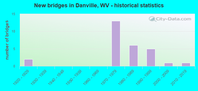
- New bridges - historical statistics
- 21920-1929
- 131970-1979
- 61980-1989
- 51990-1999
- 12000-2009
- 12010-2019
FCC Registered Broadcast Land Mobile Towers: 9 (See the full list of FCC Registered Broadcast Land Mobile Towers in Danville, WV)
FCC Registered Microwave Towers: 9 (See the full list of FCC Registered Microwave Towers in this town)
FCC Registered Paging Towers: 1 (See the full list of FCC Registered Paging Towers)
FCC Registered Amateur Radio Licenses: 44 (See the full list of FCC Registered Amateur Radio Licenses in Danville)
2003 - 2018 National Fire Incident Reporting System (NFIRS) incidents
- Fire incident types reported to NFIRS in Danville, WV
- 35657.4%Structure Fires
- 12720.5%Outside Fires
- 11318.2%Mobile Property/Vehicle Fires
- 243.9%Other
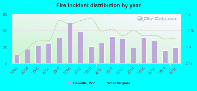 Based on the data from the years 2003 - 2018 the average number of fire incidents per year is 39. The highest number of fires - 74 took place in 2008, and the least - 16 in 2003. The data has a rising trend.
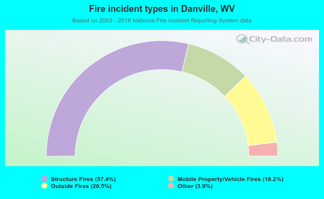 When looking into fire subcategories, the most incidents belonged to: Structure Fires (57.4%), and Outside Fires (20.5%).
| Most common first names in Danville, WV among deceased individuals | ||
| Name | Count | Lived (average) |
|---|---|---|
| James | 42 | 71.3 years |
| William | 24 | 72.0 years |
| John | 15 | 70.2 years |
| Mary | 14 | 76.6 years |
| Robert | 13 | 72.2 years |
| George | 13 | 75.5 years |
| Virginia | 11 | 63.5 years |
| Howard | 10 | 78.0 years |
| Carl | 10 | 68.1 years |
| Edith | 10 | 75.4 years |
| Most common last names in Danville, WV among deceased individuals | ||
| Last name | Count | Lived (average) |
|---|---|---|
| Miller | 69 | 74.3 years |
| Ball | 32 | 71.9 years |
| Hager | 31 | 73.6 years |
| Thompson | 26 | 73.7 years |
| Barker | 23 | 72.3 years |
| Chambers | 22 | 81.9 years |
| Price | 22 | 77.1 years |
| White | 21 | 74.7 years |
| Smith | 19 | 76.8 years |
| Berry | 19 | 66.6 years |
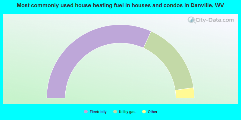
- 64.2%Electricity
- 32.1%Utility gas
- 2.2%Fuel oil, kerosene, etc.
- 1.5%Bottled, tank, or LP gas
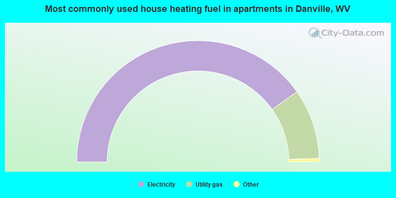
- 81.1%Electricity
- 18.9%Utility gas
Danville compared to West Virginia state average:
- Median household income below state average.
- Median house value below state average.
- Unemployed percentage significantly below state average.
- Hispanic race population percentage significantly below state average.
- Median age significantly above state average.
- Foreign-born population percentage significantly below state average.
- Renting percentage above state average.
- Length of stay since moving in above state average.
- Institutionalized population percentage significantly above state average.
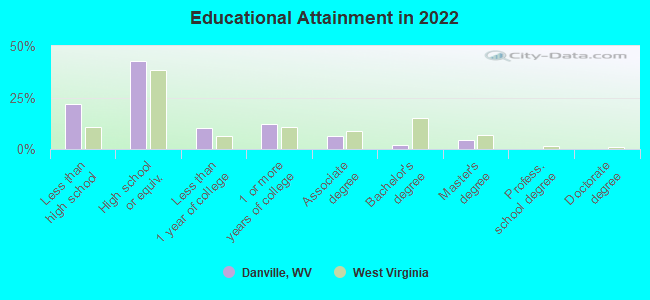
- Percentage of population with a bachelor's degree or higher significantly below state average.