Dee, Oregon
Submit your own pictures of this place and show them to the world
- OSM Map
- General Map
- Google Map
- MSN Map

| Males: 541 | |
| Females: 517 |
| Median resident age: | 33.3 years |
| Oregon median age: | 36.3 years |
Zip code: 97041
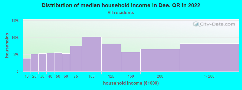
| Dee: | $75,588 |
| OR: | $75,657 |
Estimated per capita income in 2022: $36,232 (it was $14,712 in 2000)
Dee CCD income, earnings, and wages data
Estimated median house or condo value in 2022: $651,026 (it was $177,100 in 2000)
| Dee: | $651,026 |
| OR: | $475,600 |
Detailed information about poverty and poor residents in Dee, OR
Compare current foreclosures near Dee, OR:
| Photo | Address | Area | Beds / Baths | Price | Details |
|---|---|---|---|---|---|

|
#1
Alpine Ln
Carson, WA 98610
|
1,592 sq. feet
|
2 baths 3 beds |
show details | |

|
#2
Dee Hwy
Hood River, OR 97031
|
1,448 sq. feet
|
2 baths 2 beds |
show details | |

|
#3
Foster Ct
Hood River, OR 97031
|
1,819 sq. feet
|
2 baths 3 beds |
show details | |

|
#4
22nd St
Hood River, OR 97031
|
2,289 sq. feet
|
2 baths 4 beds |
show details | |

|
#5
Maxs Pl
Hood River, OR 97031
|
1,868 sq. feet
|
2 baths 3 beds |
show details | |

|
#6
Kelly Henke Rd
Stevenson, WA 98648
|
1,296 sq. feet
|
2 baths 3 beds |
show details | |

|
#7
22nd St
Hood River, OR 97031
|
1,929 sq. feet
|
2 baths 3 beds |
show details | |

|
#8
State St
Hood River, OR 97031
|
1,912 sq. feet
|
2 baths 5 beds |
show details | |

|
#9
3rd Ave Unit 68
Mosier, OR 97040
|
- sq. feet
|
2 baths 2 beds |
show details | |

|
#10
Red Hill Dr
Mount Hood Parkdale, OR 97041
|
- sq. feet
|
- baths - beds |
show details |
| Photo | Address | Area | Beds / Baths | Price | Details |
|---|---|---|---|---|---|

|
#11
Frankton Rd
Hood River, OR 97031
|
- sq. feet
|
- baths - beds |
show details | |

|
#12
Cascade Ave Apt 103
Hood River, OR 97031
|
- sq. feet
|
- baths - beds |
show details | |

|
#13
Eugene St Apt 1
Hood River, OR 97031
|
- sq. feet
|
- baths - beds |
show details | |

|
#14
SW Brislawn Loop Rd
White Salmon, WA 98672
|
- sq. feet
|
- baths - beds |
show details | |

|
#15
N Elm St
Bingen, WA 98605
|
- sq. feet
|
- baths - beds |
show details | |

|
Check over 1 million property listings on Foreclosure.com!
|
browse all offers | |||

- 66364.7%White alone
- 29228.5%Hispanic
- 373.6%Asian alone
- 141.4%Two or more races
- 131.3%American Indian alone
- 40.4%Other race alone
- 10.10%Native Hawaiian and Other
Pacific Islander alone

Races in Dee detailed stats: ancestries, foreign born residents, place of birth
 Recent articles from our blog. Our writers, many of them Ph.D. graduates or candidates, create easy-to-read articles on a wide variety of topics.
Current Local Time: PST time zone
Elevation: 2000 feet
Land area: 127.6 square miles.
Population density: 8.3 people per square mile (very low).

| Dee CCD: | 0.7% ($1,309) |
| Oregon: | 1.2% ($1,687) |
Nearest city with pop. 50,000+: Gresham, OR  (36.3 miles , pop. 90,205).
Nearest city with pop. 200,000+: Portland, OR (46.0 miles , pop. 529,121).
Nearest city with pop. 1,000,000+: Los Angeles, CA (811.6 miles , pop. 3,694,820).
Nearest cities:
), ), Latitude: 45.54 N, Longitude: 121.69 W
Area code commonly used in this area: 541

| Here: | 3.0% |
| Oregon: | 3.9% |
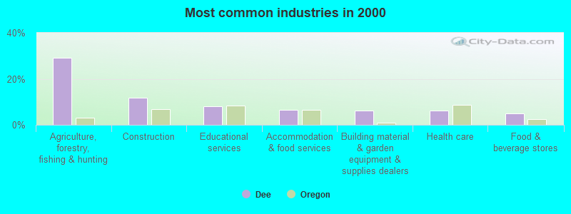
- Agriculture, forestry, fishing & hunting (29.3%)
- Construction (11.8%)
- Educational services (8.2%)
- Accommodation & food services (6.5%)
- Building material & garden equipment & supplies dealers (6.3%)
- Health care (6.1%)
- Food & beverage stores (4.8%)
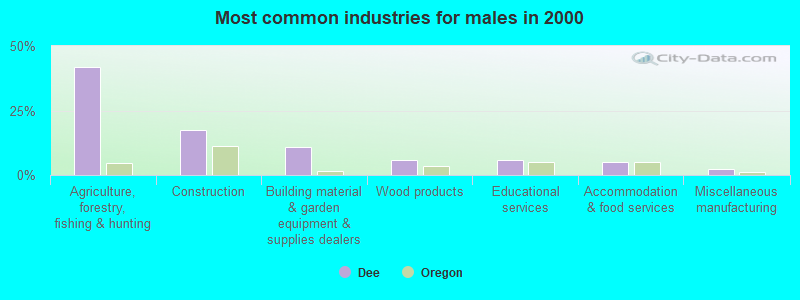
- Agriculture, forestry, fishing & hunting (41.9%)
- Construction (17.6%)
- Building material & garden equipment & supplies dealers (10.8%)
- Wood products (5.7%)
- Educational services (5.7%)
- Accommodation & food services (5.0%)
- Miscellaneous manufacturing (2.5%)
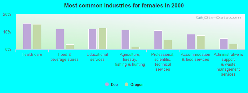
- Health care (14.8%)
- Food & beverage stores (11.7%)
- Educational services (11.7%)
- Agriculture, forestry, fishing & hunting (11.2%)
- Professional, scientific, technical services (10.7%)
- Accommodation & food services (8.7%)
- Administrative & support & waste management services (6.1%)
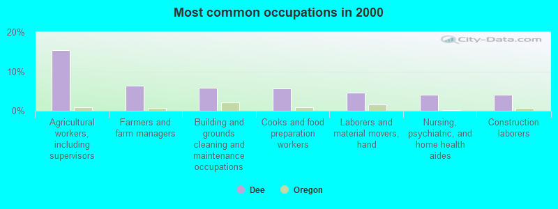
- Agricultural workers, including supervisors (15.4%)
- Farmers and farm managers (6.3%)
- Building and grounds cleaning and maintenance occupations (5.9%)
- Cooks and food preparation workers (5.7%)
- Laborers and material movers, hand (4.6%)
- Nursing, psychiatric, and home health aides (4.0%)
- Construction laborers (4.0%)
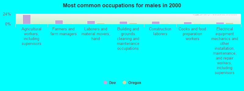
- Agricultural workers, including supervisors (22.2%)
- Farmers and farm managers (9.3%)
- Laborers and material movers, hand (7.9%)
- Building and grounds cleaning and maintenance occupations (6.8%)
- Construction laborers (6.8%)
- Cooks and food preparation workers (5.0%)
- Electrical equipment mechanics and other installation, maintenance, and repair workers, including supervisors (4.7%)
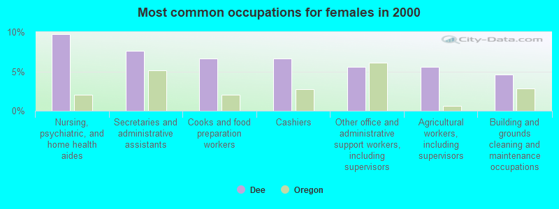
- Nursing, psychiatric, and home health aides (9.7%)
- Secretaries and administrative assistants (7.7%)
- Cooks and food preparation workers (6.6%)
- Cashiers (6.6%)
- Other office and administrative support workers, including supervisors (5.6%)
- Agricultural workers, including supervisors (5.6%)
- Building and grounds cleaning and maintenance occupations (4.6%)
Average climate in Dee, Oregon
Based on data reported by over 4,000 weather stations


(lower is better)
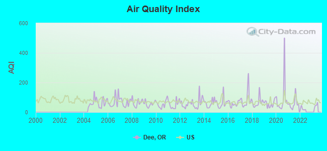
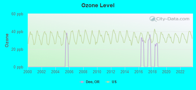
Air Quality Index (AQI) level in 2021 was 58.0. This is better than average.
| City: | 58.0 |
| U.S.: | 72.6 |
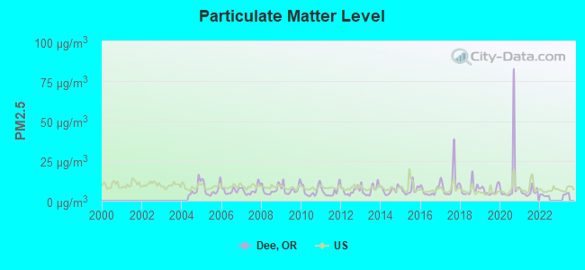
Particulate Matter (PM2.5) [µg/m3] level in 2021 was 5.57. This is significantly better than average. Closest monitor was 14.0 miles away from the city center.
| City: | 5.57 |
| U.S.: | 8.11 |
Earthquake activity:
Dee-area historical earthquake activity is significantly above Oregon state average. It is 1511% greater than the overall U.S. average.On 4/13/1949 at 19:55:42, a magnitude 7.0 (7.0 UK, Class: Major, Intensity: VIII - XII) earthquake occurred 124.2 miles away from the city center, causing $80,000,000 total damage
On 2/28/2001 at 18:54:32, a magnitude 6.8 (6.5 MB, 6.6 MS, 6.8 MW, Class: Strong, Intensity: VII - IX) earthquake occurred 115.1 miles away from Dee center, causing $2,000,000,000 total damage and $305,000,000 insured losses
On 2/28/2001 at 18:54:32, a magnitude 6.8 (6.8 MD, Depth: 32.2 mi) earthquake occurred 121.5 miles away from the city center
On 4/29/1965 at 15:28:43, a magnitude 6.6 (6.6 UK) earthquake occurred 126.4 miles away from Dee center, causing $28,000,000 total damage
On 1/31/1922 at 13:17:28, a magnitude 7.6 (7.6 UK) earthquake occurred 387.5 miles away from Dee center
On 10/3/1915 at 06:52:48, a magnitude 7.6 (7.6 UK) earthquake occurred 408.1 miles away from Dee center
Magnitude types: body-wave magnitude (MB), duration magnitude (MD), surface-wave magnitude (MS), moment magnitude (MW)
Natural disasters:
The number of natural disasters in Hood River County (11) is smaller than the US average (15).Major Disasters (Presidential) Declared: 7
Emergencies Declared: 1
Causes of natural disasters: Floods: 6, Landslides: 3, Mudslides: 3, Storms: 3, Winter Storms: 3, Fires: 2, Heavy Rain: 1, Hurricane: 1, Snow: 1, Other: 1 (Note: some incidents may be assigned to more than one category).
Hospitals and medical centers near Dee:
- HOOD RIVER CARE CENTER (Nursing Home, about 13 miles away; HOOD RIVER, OR)
- PROVIDENCE HOOD RIVER MEMORIAL HOSPITAL Critical Access Hospitals (about 14 miles away; HOOD RIVER, OR)
- RAY YASUI DIALYSIS CENTER (Dialysis Facility, about 14 miles away; HOOD RIVER, OR)
- HEART OF HOSPICE, LLC (Hospital, about 15 miles away; HOOD RIVER, OR)
Amtrak stations near Dee:
Colleges/universities with over 2000 students nearest to Dee:
- Mt Hood Community College (about 35 miles; Gresham, OR; Full-time enrollment: 11,847)
- Clackamas Community College (about 46 miles; Oregon City, OR; FT enrollment: 4,261)
- Concordia University-Portland (about 46 miles; Portland, OR; FT enrollment: 3,996)
- Clark College (about 47 miles; Vancouver, WA; FT enrollment: 9,330)
- Lewis & Clark College (about 48 miles; Portland, OR; FT enrollment: 2,864)
- Portland State University (about 49 miles; Portland, OR; FT enrollment: 21,450)
- University of Portland (about 51 miles; Portland, OR; FT enrollment: 4,030)
Points of interest:
Notable locations in Dee: Trout Creek (A), Dee Flat Guard Station (B), Hood River Hatchery (C), Wahtum Lake Guard Station (D), Lost Lake Recreation Site (E), Reservoir Campground (F), Ladd Creek Campground (G), Dee Flat Seed Orchard (H), Winans (I), Lost Lake Boat Ramp (J), Red Hill Guard Station (K), Parkdale Sewer Treatment Plant (L), Bald Mountain Shelter (M), Dee Rural Fire Protection District (N), Lost Lake Ranger Station (O). Display/hide their locations on the map
Church in Dee: Parkdale Baptist Church (A). Display/hide its location on the map
Lakes and reservoirs: Lost Lake (A), Scout Lake (B), Perry Lake (C), Ottertail Lake (D), Black Lake (E), Searra Casa Reservoir (F). Display/hide their locations on the map
Streams, rivers, and creeks: Lake Branch (A), Ladd Creek (B), Shingle Creek (C), Cedar Branch (D), Midget Creek (E), Jones Creek (F), Inlet Creek (G), Indian Creek (H), Green Point Creek (I). Display/hide their locations on the map
Park in Dee: Kingsley Reservoir County Park (1). Display/hide its location on the map
| This place: | 2.7 people |
| Oregon: | 2.5 people |
| This place: | 71.5% |
| Whole state: | 63.4% |
| This place: | 7.3% |
| Whole state: | 8.0% |
Likely homosexual households (counted as self-reported same-sex unmarried-partner households)
- Lesbian couples: 0.5% of all households
- Gay men: 0.8% of all households
| This place: | 15.0% |
| Whole state: | 11.6% |
| This place: | 8.2% |
| Whole state: | 5.0% |
60 people in agriculture workers' dormitories on farms in 2000
8 people in unknown juvenile institutions in 2000
For population 15 years and over in Dee:
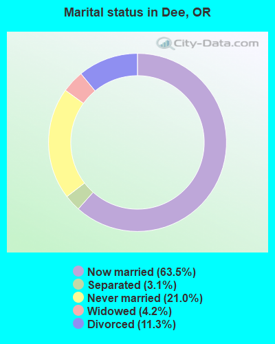
- Never married: 21.0%
- Now married: 63.5%
- Separated: 3.1%
- Widowed: 4.2%
- Divorced: 11.3%
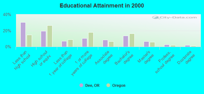
For population 25 years and over in Dee:
- High school or higher: 69.7%
- Bachelor's degree or higher: 24.5%
- Graduate or professional degree: 11.0%
- Unemployed: 6.7%
- Mean travel time to work (commute): 23.7 minutes
| Here: | 19.9 |
| Oregon average: | 11.5 |
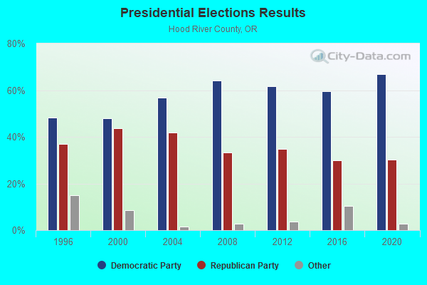
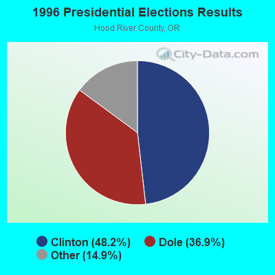
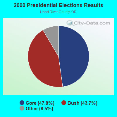
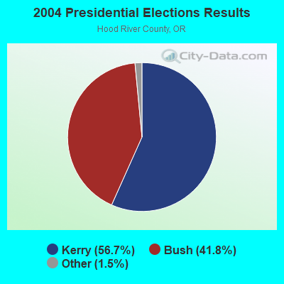
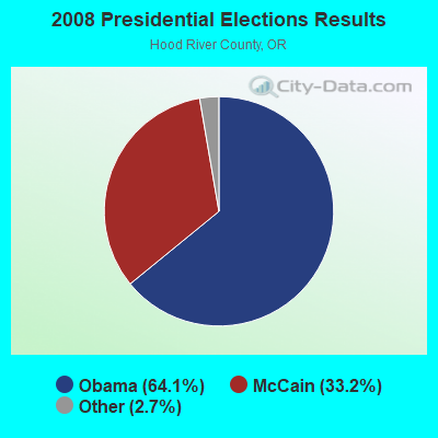
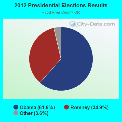
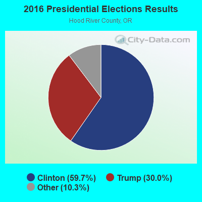
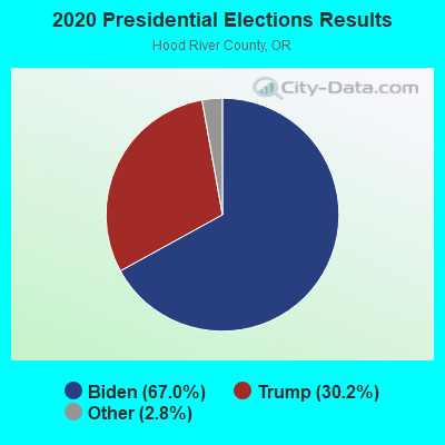
Graphs represent county-level data. Detailed 2008 Election Results
Religion statistics for Dee, OR (based on Hood River County data)
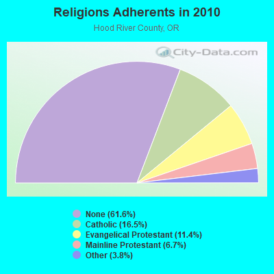
| Religion | Adherents | Congregations |
|---|---|---|
| Catholic | 3,693 | 1 |
| Evangelical Protestant | 2,545 | 24 |
| Mainline Protestant | 1,505 | 7 |
| Other | 844 | 3 |
| None | 13,759 | - |
Food Environment Statistics:
| Here: | 3.77 / 10,000 pop. |
| Oregon: | 2.03 / 10,000 pop. |
| Hood River County: | 1.42 / 10,000 pop. |
| Oregon: | 2.01 / 10,000 pop. |
| This county: | 4.25 / 10,000 pop. |
| Oregon: | 1.69 / 10,000 pop. |
| Hood River County: | 13.68 / 10,000 pop. |
| Oregon: | 9.93 / 10,000 pop. |
| This county: | 6.8% |
| Oregon: | 7.4% |
| Hood River County: | 27.3% |
| Oregon: | 25.6% |
| Hood River County: | 13.8% |
| State: | 14.2% |
Strongest AM radio stations in Dee:
- KXL (750 AM; 50 kW; PORTLAND, OR; Owner: ROSE CITY RADIO CORPORATION)
- KPOJ (620 AM; 50 kW; PORTLAND, OR; Owner: CITICASTERS LICENSES, L.P.)
- KPAM (860 AM; 50 kW; TROUTDALE, OR; Owner: PAMPLIN BROADCASTING-OREGON, INC.)
- KOTK (1080 AM; 50 kW; PORTLAND, OR; Owner: FISHER BROADCASTING - PORTLAND RADIO, L.L.C.)
- KEX (1190 AM; 50 kW; PORTLAND, OR; Owner: CITICASTERS LICENSES, L.P.)
- KKAD (1550 AM; 50 kW; VANCOUVER, WA; Owner: PAMPLIN BROADCASTING-WASHINGTON, INC)
- KKSN (1520 AM; 50 kW; OREGON CITY, OR; Owner: ENTERCOM PORTLAND LICENSE, LLC)
- KFXX (910 AM; 10 kW; VANCOUVER, WA; Owner: ENTERCOM PORTLAND LICENSE, LLC (DE))
- KODL (1440 AM; 5 kW; THE DALLES, OR; Owner: LARSON-WYNN, INC.)
- KIHR (1340 AM; 1 kW; HOOD RIVER, OR; Owner: COLUMBIA GORGE BROADCASTERS, INC.)
- KKSL (1290 AM; 10 kW; LAKE OSWEGO, OR; Owner: ABC, INC.)
- KIRO (710 AM; 50 kW; SEATTLE, WA; Owner: ENTERCOM SEATTLE LICENSE, LLC)
- KGUY (1010 AM; daytime; 4 kW; MILWAUKIE, OR; Owner: NORTHWEST RADIO BROADCASTING COMPANY)
Strongest FM radio stations in Dee:
- KLVP-FM (88.7 FM; CHERRYVILLE, OR; Owner: EDUCATIONAL MEDIA FOUNDATION)
- KZRI (90.3 FM; WELCHES, OR; Owner: EDUCATIONAL MEDIA FOUNDATION)
- KBNO-FM (89.3 FM; WHITE SALMON, WA; Owner: WORLD RADIO NETWORK, INC.)
- KQHR (90.1 FM; HOOD RIVER, OR; Owner: KBPS PUBLIC RADIO FOUNDATION)
- KMCQ (104.5 FM; THE DALLES, OR; Owner: MID-COLUMBIA BROADCASTING, INC.)
- K215CR (90.9 FM; THE DALLES, OR; Owner: EDUCATIONAL MEDIA FOUNDATION)
- K256AC (99.1 FM; THE DALLES, OR; Owner: CATHOLIC BROADCASTING NORTHWEST, INC)
- K273AJ (102.5 FM; ELWOOD, OR; Owner: CALVARY CHAPEL OF TWIN FALLS, INC.)
- KYYT (102.3 FM; GOLDENDALE, WA; Owner: HAYSTACK BROADCASTING, INC.)
- KACI-FM (97.7 FM; THE DALLES, OR; Owner: COLUMBIA GORGE BROADCASTERS, INC.)
- KMSW (92.7 FM; THE DALLES, OR; Owner: M.S.W. COMMUNICATIONS, L.L.C..)
- KRSK (105.1 FM; MOLALLA, OR; Owner: ENTERCOM PORTLAND LICENSE, LLC)
- KINK (101.9 FM; PORTLAND, OR; Owner: INFINITY RADIO OPERATIONS INC.)
- KKCW (103.3 FM; BEAVERTON, OR; Owner: CITICASTERS LICENSES, L.P.)
- K273AI (102.5 FM; ARIEL, WA; Owner: CALVARY CHAPEL OF TWIN FALLS, INC.)
- KOPB-FM (91.5 FM; PORTLAND, OR; Owner: OREGON PUBLIC BROADCASTING)
- KPDQ-FM (93.7 FM; PORTLAND, OR; Owner: SALEM MEDIA OF OREGON, INC.)
- KRVO (105.9 FM; VANCOUVER, WA; Owner: CITICASTERS LICENSES, L.P.)
- KKRZ (100.3 FM; PORTLAND, OR; Owner: CITICASTERS LICENSES, L.P.)
- KUFO-FM (101.1 FM; PORTLAND, OR; Owner: INFINITY RADIO OPERATIONS INC.)
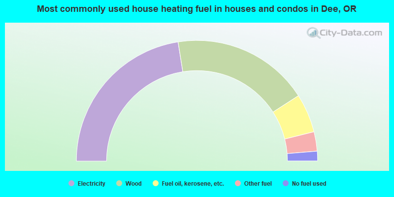
- 45.0%Electricity
- 36.8%Wood
- 10.4%Fuel oil, kerosene, etc.
- 5.2%Other fuel
- 2.6%No fuel used
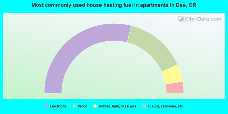
- 58.0%Electricity
- 28.6%Wood
- 8.0%Bottled, tank, or LP gas
- 5.4%Fuel oil, kerosene, etc.
Dee compared to Oregon state average:
- Unemployed percentage below state average.
- Black race population percentage significantly below state average.
- Hispanic race population percentage above state average.
- Foreign-born population percentage significantly below state average.
- Length of stay since moving in significantly above state average.
- Number of rooms per house significantly below state average.
- House age significantly below state average.
- Number of college students significantly below state average.
Dee on our top lists:
- #13 on the list of "Top 101 cities with the largest percentage of people in agriculture workers' dormitories on farms (population 1,000+)"
- #46 on the list of "Top 101 cities with the largest percentage of people in unknown juvenile institutions (population 1,000+)"
- #87 on the list of "Top 101 cities with the most residents born in Panama (population 500+)"