East Kern, California
Submit your own pictures of this place and show them to the world
- OSM Map
- General Map
- Google Map
- MSN Map

| Males: 41,768 | |
| Females: 40,562 |
| Median resident age: | 34.0 years |
| California median age: | 33.3 years |
Zip code: 93505
| East Kern: | $78,298 |
| CA: | $91,551 |
Estimated per capita income in 2022: $34,709 (it was $19,149 in 2000)
East Kern CCD income, earnings, and wages data
Estimated median house or condo value in 2022: $267,248 (it was $72,400 in 2000)
| East Kern: | $267,248 |
| CA: | $715,900 |
Mean prices in 2022: all housing units: $366,187; detached houses: $384,471; townhouses or other attached units: $303,616; in 2-unit structures: $562,075; in 3-to-4-unit structures: $224,286; in 5-or-more-unit structures: $262,914; mobile homes: $180,289; occupied boats, rvs, vans, etc.: $173,886
Detailed information about poverty and poor residents in East Kern, CA


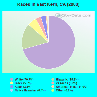
- 49,24570.7%White alone
- 10,99515.8%Hispanic
- 3,8675.6%Black alone
- 2,2453.2%Two or more races
- 2,1803.1%Asian alone
- 6861.0%American Indian alone
- 2470.4%Native Hawaiian and Other
Pacific Islander alone - 1490.2%Other race alone
 Recent articles from our blog. Our writers, many of them Ph.D. graduates or candidates, create easy-to-read articles on a wide variety of topics.
Current Local Time: PST time zone
Land area: 1809.0 square miles.
Population density: 46 people per square mile (very low).

| East Kern CCD: | 1.2% ($875) |
| California: | 0.8% ($1,564) |
Nearest city with pop. 200,000+: Bakersfield, CA  (61.3 miles , pop. 247,057).
Nearest city with pop. 1,000,000+: Los Angeles, CA (78.9 miles , pop. 3,694,820).
Nearest cities:
), ), Latitude: 35.18 N, Longitude: 117.97 W
Area code commonly used in this area: 760

| Here: | 8.7% |
| California: | 5.1% |
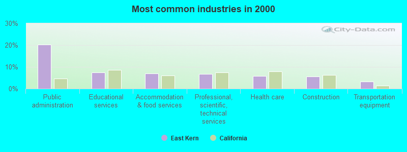
- Public administration (20.2%)
- Educational services (7.4%)
- Accommodation & food services (6.9%)
- Professional, scientific, technical services (6.8%)
- Health care (5.8%)
- Construction (5.6%)
- Transportation equipment (3.2%)
- Public administration (23.7%)
- Construction (8.5%)
- Professional, scientific, technical services (7.5%)
- Accommodation & food services (5.2%)
- Transportation equipment (5.0%)
- Mining, quarrying, oil & gas extraction (4.7%)
- Administrative & support & waste management services (3.3%)
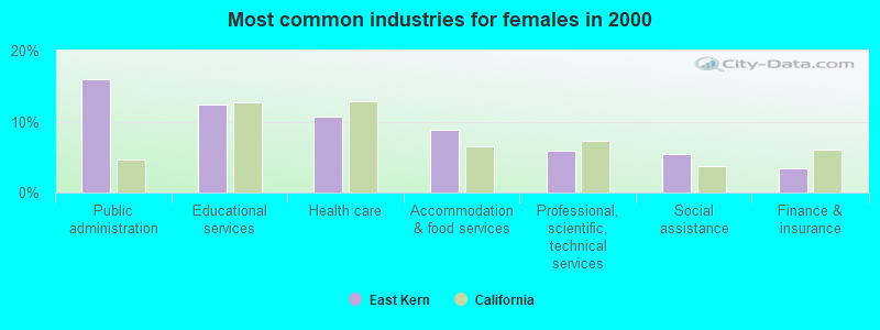
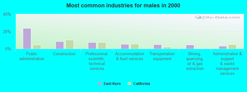
- Public administration (16.0%)
- Educational services (12.4%)
- Health care (10.7%)
- Accommodation & food services (8.9%)
- Professional, scientific, technical services (5.9%)
- Social assistance (5.4%)
- Finance & insurance (3.4%)
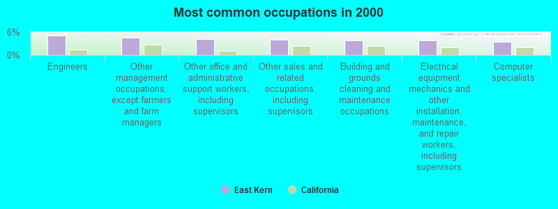
- Engineers (5.1%)
- Other management occupations, except farmers and farm managers (4.5%)
- Other office and administrative support workers, including supervisors (4.2%)
- Other sales and related occupations, including supervisors (3.9%)
- Building and grounds cleaning and maintenance occupations (3.9%)
- Electrical equipment mechanics and other installation, maintenance, and repair workers, including supervisors (3.8%)
- Computer specialists (3.4%)
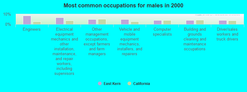
- Engineers (8.5%)
- Electrical equipment mechanics and other installation, maintenance, and repair workers, including supervisors (6.7%)
- Other management occupations, except farmers and farm managers (4.9%)
- Vehicle and mobile equipment mechanics, installers, and repairers (4.8%)
- Computer specialists (4.0%)
- Building and grounds cleaning and maintenance occupations (3.8%)
- Driver/sales workers and truck drivers (3.8%)
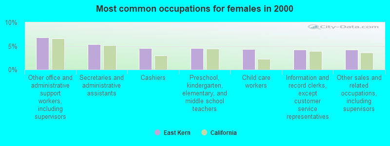
- Other office and administrative support workers, including supervisors (6.8%)
- Secretaries and administrative assistants (5.4%)
- Cashiers (4.6%)
- Preschool, kindergarten, elementary, and middle school teachers (4.5%)
- Child care workers (4.3%)
- Information and record clerks, except customer service representatives (4.3%)
- Other sales and related occupations, including supervisors (4.2%)
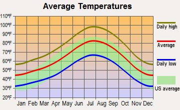
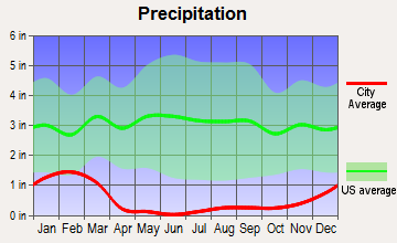
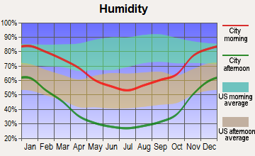
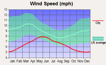
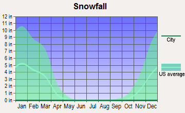
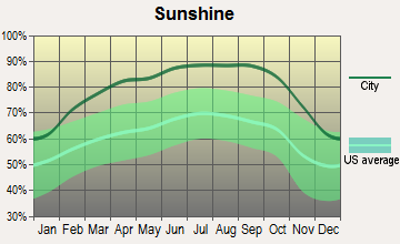
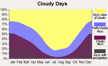
Average climate in East Kern, California
Based on data reported by over 4,000 weather stations
(lower is better)
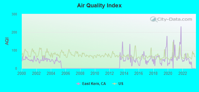
Air Quality Index (AQI) level in 2022 was 49.1. This is significantly better than average.
| City: | 49.1 |
| U.S.: | 72.6 |
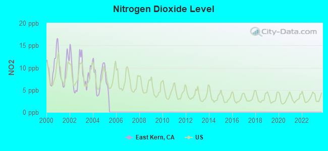
Nitrogen Dioxide (NO2) [ppb] level in 2004 was 7.76. This is significantly worse than average. Closest monitor was 13.4 miles away from the city center.
| City: | 7.76 |
| U.S.: | 5.11 |
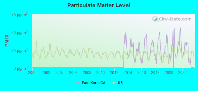
Particulate Matter (PM10) [µg/m3] level in 2022 was 24.9. This is worse than average. Closest monitor was 12.8 miles away from the city center.
| City: | 24.9 |
| U.S.: | 19.2 |
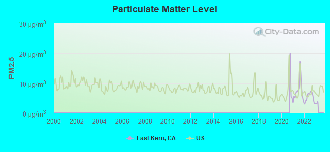
Particulate Matter (PM2.5) [µg/m3] level in 2022 was 5.28. This is significantly better than average. Closest monitor was 13.4 miles away from the city center.
| City: | 5.28 |
| U.S.: | 8.11 |
Earthquake activity:
East Kern-area historical earthquake activity is significantly above California state average. It is 7922% greater than the overall U.S. average.On 7/21/1952 at 11:52:14, a magnitude 7.7 (7.7 UK, Class: Major, Intensity: VIII - XII) earthquake occurred 59.6 miles away from the city center, causing $50,000,000 total damage
On 6/28/1992 at 11:57:34, a magnitude 7.6 (6.2 MB, 7.6 MS, 7.3 MW, Depth: 0.7 mi) earthquake occurred 106.8 miles away from the city center, causing 3 deaths (1 shaking deaths, 2 other deaths) and 400 injuries, causing $100,000,000 total damage and $40,000,000 insured losses
On 10/16/1999 at 09:46:44, a magnitude 7.4 (6.3 MB, 7.4 MS, 7.2 MW, 7.3 ML) earthquake occurred 98.4 miles away from East Kern center
On 11/4/1927 at 13:51:53, a magnitude 7.5 (7.5 UK) earthquake occurred 174.3 miles away from the city center
On 6/28/1992 at 15:05:30, a magnitude 6.9 (6.3 MB, 6.7 MS, 6.5 MW, 6.9 ME, Depth: 3.1 mi, Class: Strong, Intensity: VII - IX) earthquake occurred 89.8 miles away from the city center
On 1/17/1994 at 12:30:55, a magnitude 6.8 (6.4 MB, 6.8 MS, 6.7 MW, Depth: 11.4 mi) earthquake occurred 78.6 miles away from East Kern center, causing 60 deaths (60 shaking deaths) and 7000 injuries
Magnitude types: body-wave magnitude (MB), energy magnitude (ME), local magnitude (ML), surface-wave magnitude (MS), moment magnitude (MW)
Natural disasters:
The number of natural disasters in Kern County (29) is a lot greater than the US average (15).Major Disasters (Presidential) Declared: 14
Emergencies Declared: 3
Causes of natural disasters: Fires: 12, Floods: 12, Storms: 7, Winter Storms: 5, Mudslides: 4, Landslides: 3, Freezes: 2, Drought: 1, Heavy Rain: 1, Hurricane: 1, Snow: 1, Tornado: 1, Wind: 1, Other: 1 (Note: some incidents may be assigned to more than one category).
Colleges/universities with over 2000 students nearest to East Kern:
- Cerro Coso Community College (about 32 miles; Ridgecrest, CA; Full-time enrollment: 2,420)
- Antelope Valley College (about 37 miles; Lancaster, CA; FT enrollment: 9,206)
- Barstow Community College (about 58 miles; Barstow, CA; FT enrollment: 2,120)
- Bakersfield College (about 59 miles; Bakersfield, CA; FT enrollment: 10,325)
- Victor Valley College (about 64 miles; Victorville, CA; FT enrollment: 7,630)
- College of the Canyons (about 64 miles; Santa Clarita, CA; FT enrollment: 11,307)
- Los Angeles Mission College (about 65 miles; Sylmar, CA; FT enrollment: 4,825)
Points of interest:
Notable locations in East Kern: Holland Camp (A), Desert Empire Fairgrounds (B), North Gate (C), Owens Camp (D), Cudahy Camp (E), Schmidt Camp (F), South Gate (G), Edwards Siding (H), Thundering Herd Ranch (I), Colorado Camp (J), Wagon Wheel Ranch (K), West Antelope Station (L), Yellow Aster Mill (M), Willow Springs Transportation Technical Center (N), Muroc Golf Course (O), John Hartman Garage Area (P), Tierra del Sol Championship Golf Course (Q), Silver Saddle Ranch and Country Club (R), California City Public Golf Course (S), Freeman (T). Display/hide their locations on the map
Shopping Centers: Boron Shopping Center (1), Aspen Mall Shopping Center (2), Tivoli Centre Shopping Center (3), Sierra Vista Shopping Center (4), Ridgecrest Plaza Shopping Center (5), Heritage Square Shopping Center (6). Display/hide their locations on the map
Churches in East Kern include: Bethel Missionary Baptist Church (A), Desert Christian Center (B), Family Bible Church (C), First Baptist Church of Ridgecrest (D), First Church of Christ Scientist (E), Immanuel Southern Baptist Church (F), Inyokern Baptist Church (G), Inyokern Church of Christ (H), Inyokern Community Methodist Church (I). Display/hide their locations on the map
Lakes and reservoirs: Satellite Lake (A), Buckhorn Lake (B), Rogers Lake (C), Central Park Lake (D), Watershed Reservoir (E). Display/hide their locations on the map
Streams, rivers, and creeks: Cottonwood Creek (A), Little Dixie Wash (B), Cache Creek (C), Oak Creek (D). Display/hide their locations on the map
Parks in East Kern include: Red Rock Canyon State Park (1), Borax Bill Park (2), Branch Memorial Park (3), Central Park (4), Desert Memorial Park (5), Galileo Park (6), Hellmers Park (7), Kern County Park (8), Kern County Regional Park (9). Display/hide their locations on the map
| This place: | 2.7 people |
| California: | 2.9 people |
| This place: | 68.6% |
| Whole state: | 68.7% |
| This place: | 7.3% |
| Whole state: | 7.2% |
Likely homosexual households (counted as self-reported same-sex unmarried-partner households)
- Lesbian couples: 0.3% of all households
- Gay men: 0.3% of all households
| This place: | 13.9% |
| Whole state: | 14.2% |
| This place: | 6.0% |
| Whole state: | 6.3% |
People in group quarters in East Kern in 2010:
- 2,614 people in federal prisons
- 329 people in military barracks and dormitories (nondisciplinary)
- 87 people in nursing facilities/skilled-nursing facilities
- 10 people in group homes intended for adults
- 4 people in emergency and transitional shelters (with sleeping facilities) for people experiencing homelessness
People in group quarters in East Kern in 2000:
- 733 people in military barracks, etc.
- 87 people in nursing homes
- 57 people in other noninstitutional group quarters
- 53 people in federal prisons and detention centers
- 9 people in military transient quarters for temporary residents
- 5 people in homes for the mentally ill
- 2 people in state prisons
For population 15 years and over in East Kern:
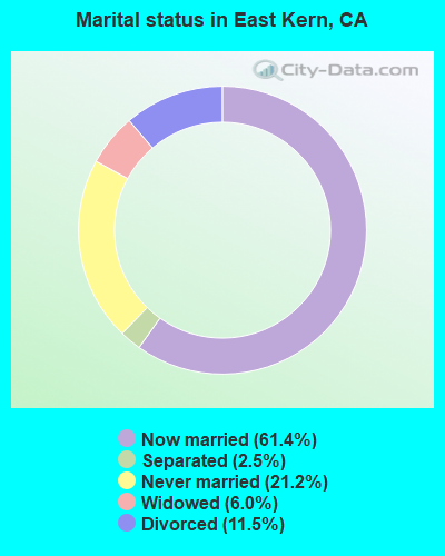
- Never married: 21.2%
- Now married: 61.4%
- Separated: 2.5%
- Widowed: 6.0%
- Divorced: 11.5%
For population 25 years and over in East Kern:
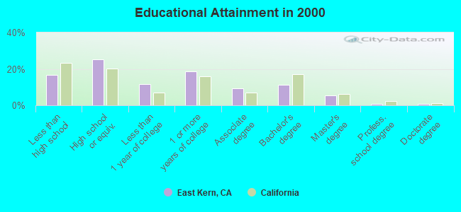
- High school or higher: 83.1%
- Bachelor's degree or higher: 18.2%
- Graduate or professional degree: 7.1%
- Unemployed: 8.8%
- Mean travel time to work (commute): 21.3 minutes
| Here: | 11.1 |
| California average: | 16.1 |
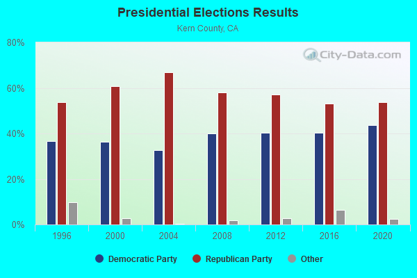
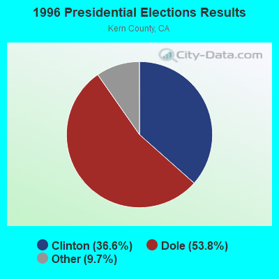
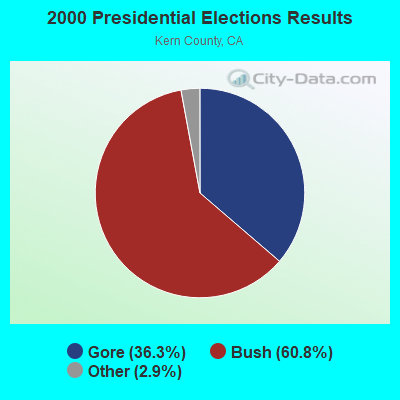
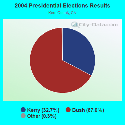
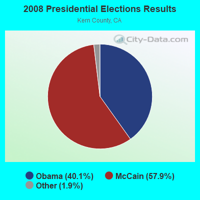
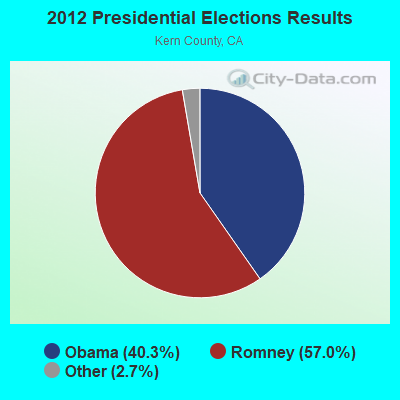
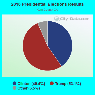
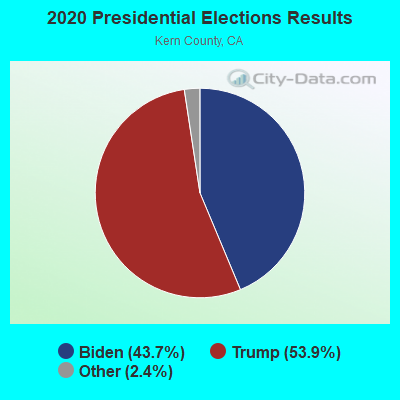
Graphs represent county-level data. Detailed 2008 Election Results
Religion statistics for East Kern, CA (based on Kern County data)
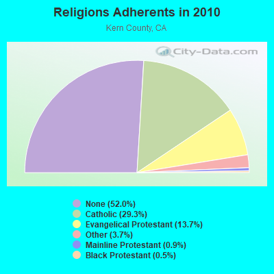
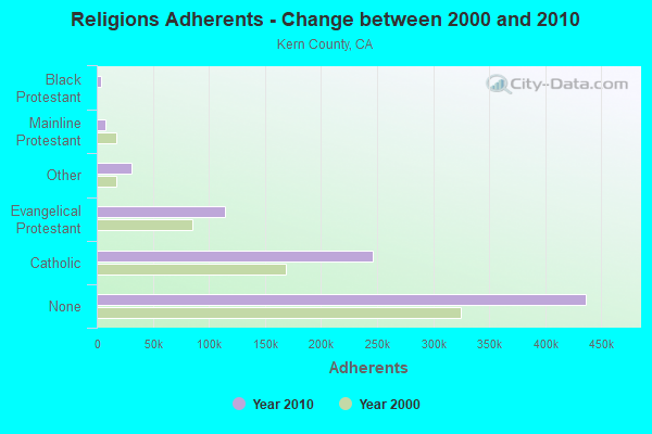
| Religion | Adherents | Congregations |
|---|---|---|
| Catholic | 245,836 | 30 |
| Evangelical Protestant | 114,724 | 436 |
| Other | 30,687 | 83 |
| Mainline Protestant | 7,459 | 38 |
| Black Protestant | 4,026 | 25 |
| Orthodox | 450 | 3 |
| None | 436,449 | - |
Food Environment Statistics:
| Kern County: | 2.41 / 10,000 pop. |
| California: | 2.14 / 10,000 pop. |
| Kern County: | 0.04 / 10,000 pop. |
| California: | 0.04 / 10,000 pop. |
| This county: | 0.80 / 10,000 pop. |
| State: | 0.62 / 10,000 pop. |
| Kern County: | 2.10 / 10,000 pop. |
| California: | 1.49 / 10,000 pop. |
| Here: | 4.60 / 10,000 pop. |
| State: | 7.42 / 10,000 pop. |
| Here: | 8.0% |
| California: | 7.3% |
| This county: | 29.4% |
| California: | 21.3% |
| Kern County: | 15.9% |
| California: | 17.9% |
4.83% of this county's 2021 resident taxpayers lived in other counties in 2020 ($47,246 average adjusted gross income)
| Here: | 4.83% |
| California average: | 5.19% |
0.03% of residents moved from foreign countries ($334 average AGI)
Kern County: 0.03% California average: 0.03%
Top counties from which taxpayers relocated into this county between 2020 and 2021:
| from Los Angeles County, CA | |
| from San Bernardino County, CA | |
| from Tulare County, CA |
4.56% of this county's 2020 resident taxpayers moved to other counties in 2021 ($61,654 average adjusted gross income)
| Here: | 4.56% |
| California average: | 6.14% |
0.03% of residents moved to foreign countries ($342 average AGI)
Kern County: 0.03% California average: 0.02%
Top counties to which taxpayers relocated from this county between 2020 and 2021:
| to Los Angeles County, CA | |
| to Tulare County, CA | |
| to San Diego County, CA |
Strongest AM radio stations in East Kern:
- KIRN (670 AM; 35 kW; SIMI VALLEY, CA; Owner: LOTUS OXNARD CORP.)
- KLAC (570 AM; 50 kW; LOS ANGELES, CA; Owner: AMFM RADIO LICENSES, L.L.C.)
- KSPN (710 AM; 50 kW; LOS ANGELES, CA; Owner: KABC-AM RADIO, INC.)
- KFI (640 AM; 50 kW; LOS ANGELES, CA; Owner: CAPSTAR TX LIMITED PARTNERSHIP)
- KFWB (980 AM; 50 kW; LOS ANGELES, CA; Owner: INFINITY BROADCASTING OPERATIONS, INC.)
- KDIS (1110 AM; 50 kW; PASADENA, CA; Owner: ABC,INC.)
- KTNQ (1020 AM; 50 kW; LOS ANGELES, CA; Owner: KTNQ-AM LICENSE CORP.)
- KPLS (830 AM; 50 kW; ORANGE, CA; Owner: CRN LICENSES, LLC)
- KXTA (1150 AM; 50 kW; LOS ANGELES, CA; Owner: CITICASTERS LICENSES, L.P.)
- KERI (1180 AM; 50 kW; WASCO-GREENACRES, CA; Owner: KWSO, INC.)
- KAVL (610 AM; 5 kW; LANCASTER, CA; Owner: CITICASTERS LICENSES, L.P.)
- KMPC (1540 AM; 50 kW; LOS ANGELES, CA; Owner: ROSE CITY RADIO CORPORATION)
- KBLA (1580 AM; 50 kW; SANTA MONICA, CA)
Strongest FM radio stations in East Kern:
- K266AH (101.1 FM; BENA, CA; Owner: CALVARY CHAPEL OF TWIN FALLS, INC.)
- KTQX (90.1 FM; BAKERSFIELD, CA; Owner: RADIO BILINGUE, INC.)
- KKZQ (100.1 FM; TEHACHAPI, CA; Owner: HIGH DESERT BROADCASTING LLC)
- KCRY (88.1 FM; MOJAVE, CA; Owner: SANTA MONICA COMMUNITY COLLEGE DISTRICT)
- KMYX-FM (92.5 FM; ARVIN, CA; Owner: FARMWORKER EDUC. RADIO NETWORK, INC.)
- KLOA-FM (104.9 FM; RIDGECREST, CA; Owner: ADELMAN COMMUNICATIONS, INC.)
- KCEL (106.9 FM; CALIFORNIA CITY, CA; Owner: KCEL RADIO, LLC)
- KRAJ (100.9 FM; JOHANNESBURG, CA; Owner: ADELMAN BROADCASTING INC.)
- KGBM (89.7 FM; RANDSBURG, CA; Owner: EDUCATIONAL MEDIA FOUNDATION)
- KCBS-FM (93.1 FM; LOS ANGELES, CA; Owner: INFINITY BROADCASTING OPERATIONS, INC.)
- KSCA (101.9 FM; GLENDALE, CA; Owner: HBC LICENSE CORPORATION)
- K212FA (90.3 FM; TEMPLE CITY, CA; Owner: EDUCATIONAL MEDIA FOUNDATION)
- KLOS (95.5 FM; LOS ANGELES, CA; Owner: KLOS-FM RADIO, INC.)
- KOST (103.5 FM; LOS ANGELES, CA; Owner: CAPSTAR TX LIMITED PARTNERSHIP)
- KLVE (107.5 FM; LOS ANGELES, CA; Owner: KLVE-FM LICENSE CORP.)
- KIIS-FM (102.7 FM; LOS ANGELES, CA; Owner: CITICASTERS LICENSES, L.P.)
- KZIQ-FM (92.7 FM; RIDGECREST, CA; Owner: JAMES KNUDSEN & DONNA KNUDSEN)
- K202DJ (88.3 FM; PALMDALE, CA; Owner: SANTA MONICA COMMUNITY COLLEGE DIST.)
- KPCC (89.3 FM; PASADENA, CA; Owner: PASADENA AREA COMMUNITY COLLEGE DISTRICT)
- KHHT (92.3 FM; LOS ANGELES, CA; Owner: AMFM RADIO LICENSES, L.L.C.)
TV broadcast stations around East Kern:
- KTRO-LP (Channel 50; LANCASTER, CA; Owner: ROBERT D. ADELMAN)
- KHIZ (Channel 64; BARSTOW, CA; Owner: SUNBELT TELEVISION, INC.)
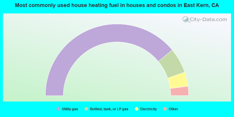
- 78.0%Utility gas
- 11.4%Bottled, tank, or LP gas
- 6.4%Electricity
- 3.4%Wood
- 0.6%Other fuel
- 0.1%No fuel used
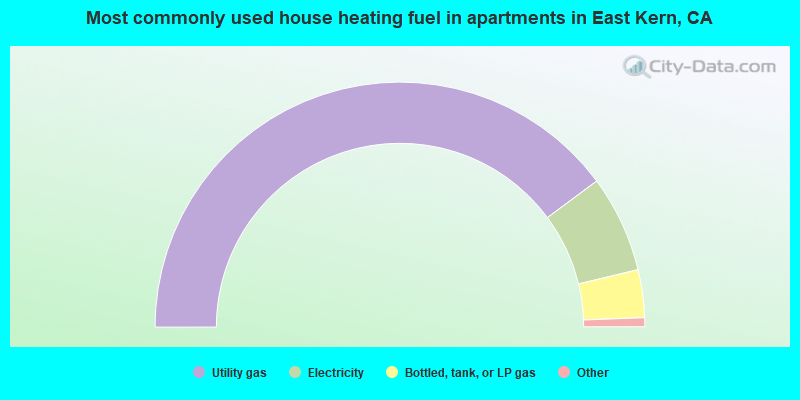
- 79.6%Utility gas
- 12.8%Electricity
- 6.3%Bottled, tank, or LP gas
- 0.4%Wood
- 0.3%Other fuel
- 0.2%Fuel oil, kerosene, etc.
- 0.2%Coal or coke
East Kern compared to California state average:
- Median house value significantly below state average.
- Unemployed percentage below state average.
- Hispanic race population percentage below state average.
- Foreign-born population percentage significantly below state average.
- Length of stay since moving in significantly above state average.
- Number of rooms per house significantly below state average.
- House age significantly below state average.
- Institutionalized population percentage above state average.
East Kern on our top lists:
- #1 on the list of "Top 101 cities with largest percentage of males in occupations: extraction workers (population 50,000+)"
- #1 on the list of "Top 101 cities with largest percentage of males in occupations: drafters, engineering, and mapping technicians (population 50,000+)"
- #1 on the list of "Top 101 cities with largest percentage of females in occupations: child care workers (population 50,000+)"
- #2 on the list of "Top 101 cities with largest percentage of females in industries: office supplies and stationery stores (population 50,000+)"
- #2 on the list of "Top 101 cities with largest percentage of females in industries: motor vehicle and parts dealers (population 50,000+)"
- #2 on the list of "Top 101 cities with largest percentage of males in industries: gasoline stations (population 50,000+)"
- #2 on the list of "Top 101 cities with largest percentage of females in occupations: librarians, curators, and archivists (population 50,000+)"
- #3 on the list of "Top 101 cities with largest percentage of males in industries: public administration (population 50,000+)"
- #3 on the list of "Top 101 cities with largest percentage of females in occupations: drafters, engineering, and mapping technicians (population 50,000+)"
- #3 on the list of "Top 100 cities with largest land areas (pop. 50,000+)"
- #3 on the list of "Top 101 cities with largest percentage of females in industries: gasoline stations (population 50,000+)"
- #4 on the list of "Top 101 cities with largest percentage of males in occupations: engineers (population 50,000+)"
- #4 on the list of "Top 101 cities with largest percentage of females in industries: social assistance (population 50,000+)"
- #6 on the list of "Top 101 cities with largest percentage of males in industries: recyclable material merchant wholesalers (population 50,000+)"
- #7 on the list of "Top 101 cities with largest percentage of females in industries: public administration (population 50,000+)"
- #8 on the list of "Top 101 cities with largest percentage of females in industries: rail transportation (population 50,000+)"
- #10 on the list of "Top 101 cities with largest percentage of females in industries: building material and garden equipment and supplies dealers (population 50,000+)"
- #11 on the list of "Top 100 cities with the largest percentage of males (pop. 50,000+)"
- #12 on the list of "Top 101 cities with largest percentage of females in industries: warehousing and storage (population 50,000+)"
- #12 on the list of "Top 101 cities with largest percentage of males in industries: chemicals (population 50,000+)"
- #59 (93505) on the list of "Top 101 zip codes with the lowest 2012 average net capital gain/loss (pop 5,000+)"
- #6 on the list of "Top 101 counties with the highest Particulate Matter (PM10) Annual air pollution readings in 2012 (µg/m3)"
- #13 on the list of "Top 101 counties with the highest carbon monoxide air pollution readings in 2012 (ppm)"
- #13 on the list of "Top 101 counties with the highest lead air pollution readings in 2012 (µg/m3)"
- #13 on the list of "Top 101 counties with the lowest lead air pollution readings in 2012 (µg/m3)"
- #17 on the list of "Top 101 counties with the highest ground withdrawal of fresh water for public supply"