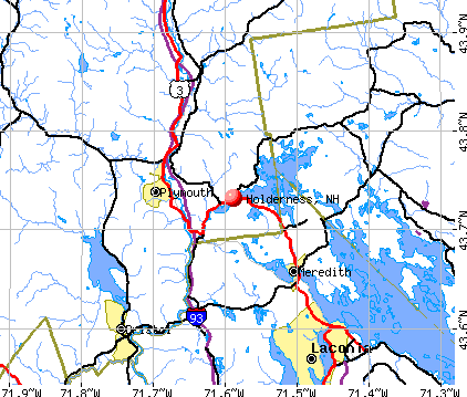
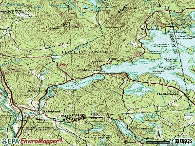
Holderness, New Hampshire
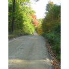
Holderness: A non-paved street in the mountains.
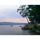
Holderness: Squam Lake in Holderness, NH
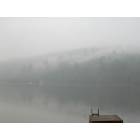
Holderness: Squam Lake after a heavy T-storm
- add
your
Submit your own pictures of this town and show them to the world
- OSM Map
- General Map
- Google Map
- MSN Map
Population change since 2000: +9.2%
 |
| Males: 1,064 | |
| Females: 1,044 |
| Median resident age: | 46.9 years |
| New Hampshire median age: | 43.9 years |
Zip codes: 03264.
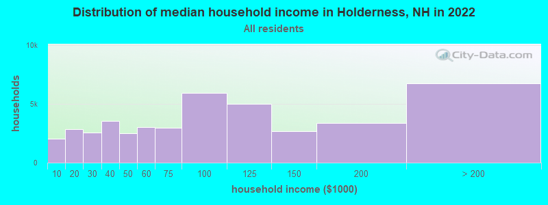
| Holderness: | $93,645 |
| NH: | $89,992 |
Estimated per capita income in 2022: $63,274 (it was $27,825 in 2000)
Holderness town income, earnings, and wages data
Estimated median house or condo value in 2022: $458,339 (it was $143,400 in 2000)
| Holderness: | $458,339 |
| NH: | $384,700 |
Mean prices in 2022: all housing units: $486,096; detached houses: $533,852; townhouses or other attached units: $375,744; in 2-unit structures: $230,260; in 3-to-4-unit structures: $242,363; in 5-or-more-unit structures: $588,257; mobile homes: $127,035
Detailed information about poverty and poor residents in Holderness, NH


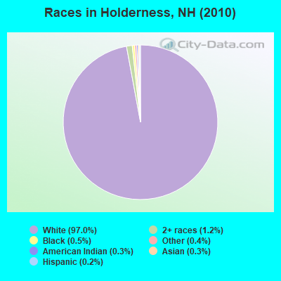
- 2,04597.0%White alone
- 261.2%Two or more races
- 100.5%Black alone
- 90.4%Other race alone
- 70.3%American Indian alone
- 70.3%Asian alone
- 40.2%Hispanic
Races in Holderness detailed stats: ancestries, foreign born residents, place of birth
According to our research of New Hampshire and other state lists, there was 1 registered sex offender living in Holderness, New Hampshire as of April 25, 2024.
The ratio of all residents to sex offenders in Holderness is 2,108 to 1.
The ratio of registered sex offenders to all residents in this city is much lower than the state average.
Type |
2015 |
2016 |
2017 |
2018 |
2019 |
2020 |
2021 |
2022 |
|---|---|---|---|---|---|---|---|---|
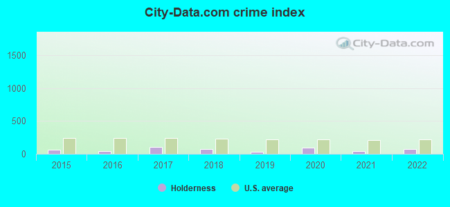
| Murders (per 100,000) | 0 (0.0) | 0 (0.0) | 0 (0.0) | 0 (0.0) | 0 (0.0) | 0 (0.0) | 0 (0.0) | 0 (0.0) |
| Rapes (per 100,000) | 0 (0.0) | 0 (0.0) | 1 (47.8) | 0 (0.0) | 0 (0.0) | 1 (47.5) | 0 (0.0) | 0 (0.0) |
| Robberies (per 100,000) | 0 (0.0) | 0 (0.0) | 1 (47.8) | 1 (47.8) | 0 (0.0) | 0 (0.0) | 0 (0.0) | 0 (0.0) |
| Assaults (per 100,000) | 2 (94.9) | 0 (0.0) | 0 (0.0) | 1 (47.8) | 0 (0.0) | 2 (95.0) | 1 (46.9) | 4 (196.4) |
| Burglaries (per 100,000) | 5 (237.3) | 3 (143.2) | 4 (191.4) | 1 (47.8) | 2 (94.8) | 5 (237.4) | 0 (0.0) | 1 (49.1) |
| Thefts (per 100,000) | 13 (617.0) | 15 (716.0) | 18 (861.2) | 22 (1,052) | 11 (521.6) | 10 (474.8) | 10 (468.8) | 10 (490.9) |
| Auto thefts (per 100,000) | 1 (47.5) | 0 (0.0) | 1 (47.8) | 1 (47.8) | 1 (47.4) | 0 (0.0) | 3 (140.6) | 3 (147.3) |
| Arson (per 100,000) | 0 (0.0) | 1 (47.7) | 0 (0.0) | 0 (0.0) | 0 (0.0) | 1 (47.5) | 0 (0.0) | 0 (0.0) |
| City-Data.com crime index | 64.1 | 38.7 | 104.3 | 73.2 | 31.3 | 92.6 | 39.4 | 74.1 |
The City-Data.com crime index weighs serious crimes and violent crimes more heavily. Higher means more crime, U.S. average is 246.1. It adjusts for the number of visitors and daily workers commuting into cities.
Crime rate in Holderness detailed stats: murders, rapes, robberies, assaults, burglaries, thefts, arson
Full-time law enforcement employees in 2021, including police officers: 6 (6 officers - 5 male; 1 female).
| Officers per 1,000 residents here: | 2.81 |
| New Hampshire average: | 2.14 |
 Recent articles from our blog. Our writers, many of them Ph.D. graduates or candidates, create easy-to-read articles on a wide variety of topics.

 | Relocation suggestions (30 replies) |
| Concord, NH weather? (18 replies) |
| Possible Relocation to New Hampshire (30 replies) |
| Move to NH - Suggested Areas & Towns? (108 replies) |
| Bad weather: do they know something we don't? (7 replies) |
| What's it like to live in or near Plymouth? (6 replies) |
Latest news from Holderness, NH collected exclusively by city-data.com from local newspapers, TV, and radio stations
Ancestries: English (23.4%), Irish (16.2%), German (13.8%), Scottish (7.6%), French (6.8%), French Canadian (6.6%).
Current Local Time: EST time zone
Incorporated in 1761
Elevation: 575 feet
Land area: 30.4 square miles.
Population density: 69 people per square mile (very low).
43 residents are foreign born (1.4% Europe, 0.4% Latin America).
| This town: | 2.2% |
| New Hampshire: | 4.4% |
| Holderness town: | 1.7% ($2,456) |
| New Hampshire: | 2.3% ($2,946) |
Nearest city with pop. 50,000+: Manchester, NH  (52.6 miles , pop. 107,006).
Nearest city with pop. 200,000+: Boston, MA (101.3 miles , pop. 589,141).
Nearest city with pop. 1,000,000+: Bronx, NY (231.7 miles , pop. 1,332,650).
Nearest cities:
Latitude: 43.74 N, Longitude: 71.59 W
Area code commonly used in this area: 603

Holderness tourist attractions:
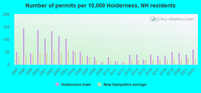
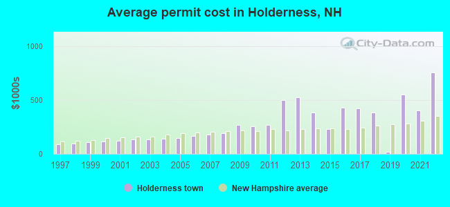
Single-family new house construction building permits:
- 2022: 12 buildings, average cost: $754,800
- 2021: 8 buildings, average cost: $400,000
- 2020: 9 buildings, average cost: $548,300
- 2019: 10 buildings, average cost: $21,200
- 2018: 7 buildings, average cost: $380,500
- 2017: 7 buildings, average cost: $419,300
- 2016: 8 buildings, average cost: $431,300
- 2015: 4 buildings, average cost: $232,500
- 2014: 8 buildings, average cost: $385,800
- 2013: 8 buildings, average cost: $520,600
- 2012: 2 buildings, average cost: $500,000
- 2011: 3 buildings, average cost: $266,700
- 2010: 6 buildings, average cost: $252,800
- 2009: 2 buildings, average cost: $270,500
- 2008: 6 buildings, average cost: $192,500
- 2007: 7 buildings, average cost: $181,500
- 2006: 10 buildings, average cost: $166,800
- 2005: 11 buildings, average cost: $149,200
- 2004: 20 buildings, average cost: $138,600
- 2003: 22 buildings, average cost: $132,800
- 2002: 26 buildings, average cost: $130,700
- 2001: 20 buildings, average cost: $121,400
- 2000: 27 buildings, average cost: $118,000
- 1999: 9 buildings, average cost: $109,200
- 1998: 28 buildings, average cost: $95,700
- 1997: 10 buildings, average cost: $87,400
| Here: | 1.6% |
| New Hampshire: | 2.5% |
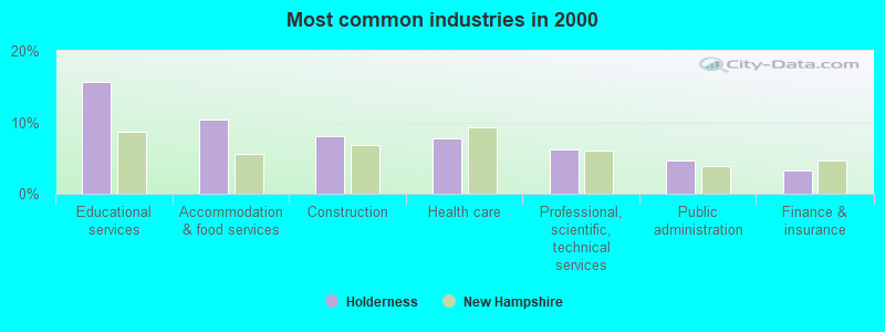
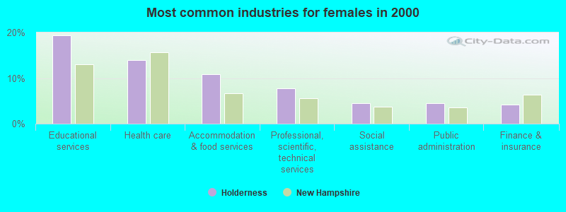
- Educational services (15.7%)
- Accommodation & food services (10.4%)
- Construction (8.1%)
- Health care (7.8%)
- Professional, scientific, technical services (6.2%)
- Public administration (4.6%)
- Finance & insurance (3.2%)
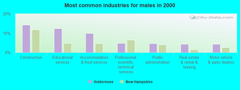
- Construction (14.3%)
- Educational services (12.5%)
- Accommodation & food services (10.0%)
- Professional, scientific, technical services (4.8%)
- Public administration (4.6%)
- Real estate & rental & leasing (4.3%)
- Motor vehicle & parts dealers (4.3%)
- Educational services (19.3%)
- Health care (14.0%)
- Accommodation & food services (10.8%)
- Professional, scientific, technical services (7.7%)
- Social assistance (4.5%)
- Public administration (4.5%)
- Finance & insurance (4.1%)
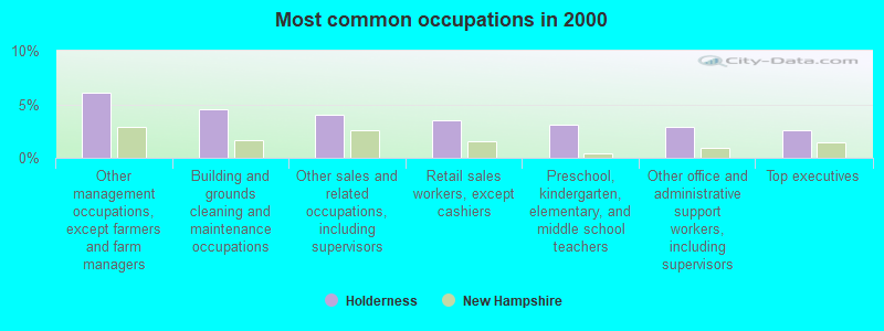
- Other management occupations, except farmers and farm managers (6.1%)
- Building and grounds cleaning and maintenance occupations (4.5%)
- Other sales and related occupations, including supervisors (4.0%)
- Retail sales workers, except cashiers (3.5%)
- Preschool, kindergarten, elementary, and middle school teachers (3.1%)
- Other office and administrative support workers, including supervisors (2.9%)
- Top executives (2.6%)
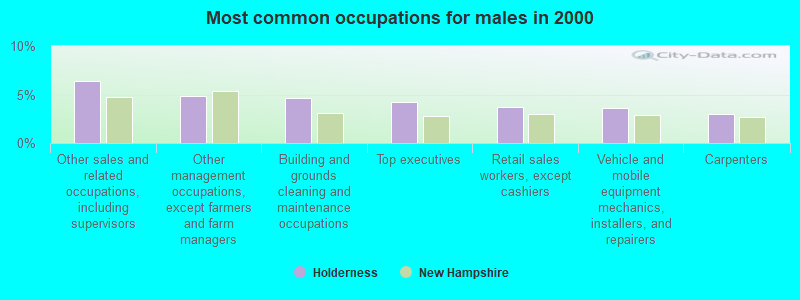
- Other sales and related occupations, including supervisors (6.4%)
- Other management occupations, except farmers and farm managers (4.8%)
- Building and grounds cleaning and maintenance occupations (4.6%)
- Top executives (4.3%)
- Retail sales workers, except cashiers (3.7%)
- Vehicle and mobile equipment mechanics, installers, and repairers (3.6%)
- Carpenters (3.0%)

- Other management occupations, except farmers and farm managers (7.5%)
- Secretaries and administrative assistants (5.1%)
- Financial clerks, except bookkeeping, accounting and auditing clerks (4.9%)
- Preschool, kindergarten, elementary, and middle school teachers (4.5%)
- Registered nurses (4.3%)
- Building and grounds cleaning and maintenance occupations (4.3%)
- Other office and administrative support workers, including supervisors (3.7%)
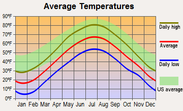
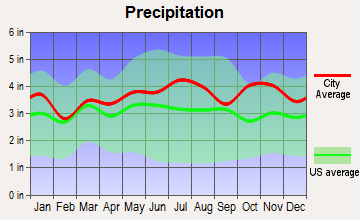
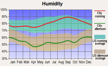
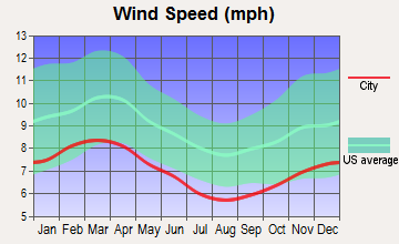
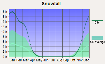
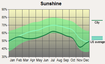
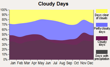
Average climate in Holderness, New Hampshire
Based on data reported by over 4,000 weather stations
(lower is better)
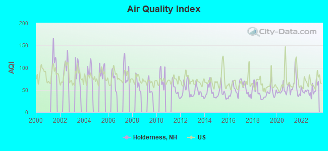
Air Quality Index (AQI) level in 2022 was 46.9. This is significantly better than average.
| City: | 46.9 |
| U.S.: | 72.6 |
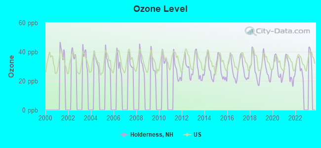
Ozone [ppb] level in 2022 was 29.8. This is about average. Closest monitor was 8.6 miles away from the city center.
| City: | 29.8 |
| U.S.: | 33.3 |
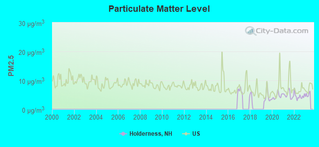
Particulate Matter (PM2.5) [µg/m3] level in 2022 was 4.52. This is significantly better than average. Closest monitor was 5.0 miles away from the city center.
| City: | 4.52 |
| U.S.: | 8.11 |
Tornado activity:
Holderness-area historical tornado activity is slightly below New Hampshire state average. It is 67% smaller than the overall U.S. average.
On 5/11/1973, a category F2 (max. wind speeds 113-157 mph) tornado 21.5 miles away from the Holderness town center .
On 7/18/1963, a category F2 tornado 21.8 miles away from the town center caused between $5000 and $50,000 in damages.
Earthquake activity:
Holderness-area historical earthquake activity is significantly above New Hampshire state average. It is 71% smaller than the overall U.S. average.On 4/20/2002 at 10:50:47, a magnitude 5.3 (5.3 ML, Depth: 3.0 mi, Class: Moderate, Intensity: VI - VII) earthquake occurred 117.5 miles away from the city center
On 10/7/1983 at 10:18:46, a magnitude 5.3 (5.1 MB, 5.3 LG, 5.1 ML) earthquake occurred 138.1 miles away from Holderness center
On 4/20/2002 at 10:50:47, a magnitude 5.2 (5.2 MB, 4.2 MS, 5.2 MW, 5.0 MW) earthquake occurred 117.6 miles away from the city center
On 1/19/1982 at 00:14:42, a magnitude 4.7 (4.5 MB, 4.7 MD, 4.5 LG, Class: Light, Intensity: IV - V) earthquake occurred 16.6 miles away from Holderness center
On 10/16/2012 at 23:12:25, a magnitude 4.7 (4.7 ML, Depth: 10.0 mi) earthquake occurred 47.8 miles away from the city center
On 8/21/1996 at 07:54:14, a magnitude 3.8 (3.8 LG, 3.6 LG, Depth: 6.2 mi, Class: Light, Intensity: II - III) earthquake occurred 32.9 miles away from Holderness center
Magnitude types: regional Lg-wave magnitude (LG), body-wave magnitude (MB), duration magnitude (MD), local magnitude (ML), surface-wave magnitude (MS), moment magnitude (MW)
Natural disasters:
The number of natural disasters in Grafton County (32) is a lot greater than the US average (15).Major Disasters (Presidential) Declared: 20
Emergencies Declared: 9
Causes of natural disasters: Floods: 16, Storms: 16, Hurricanes: 3, Snows: 3, Winter Storms: 3, Tropical Storms: 2, Blizzard: 1, Heavy Rain: 1, Ice Storm: 1, Landslide: 1, Snowfall: 1, Snowstorm: 1, Wind: 1, Other: 1 (Note: some incidents may be assigned to more than one category).
Hospitals and medical centers near Holderness:
- SPEARE MEMORIAL HOSPITAL Critical Access Hospitals (about 6 miles away; PLYMOUTH, NH)
- MOULTONBORO VNS (Home Health Center, about 10 miles away; MOULTONBOROUGH, NH)
- NEWFOUND AREA NURSING ASSN (Home Health Center, about 13 miles away; BRISTOL, NH)
- BELKNAP COUNTY NURSING HOME (Nursing Home, about 15 miles away; LACONIA, NH)
- LACONIA CENTER, GENESIS HEALTHCARE (Nursing Home, about 15 miles away; LACONIA, NH)
- COMMUNITY HEALTH AND HOSPICE (Home Health Center, about 16 miles away; LACONIA, NH)
- CENTRAL NEW HAMPSHIRE KIDNEY CENTER (Dialysis Facility, about 16 miles away; LACONIA, NH)
Colleges/universities with over 2000 students nearest to Holderness:
- Plymouth State University (about 6 miles; Plymouth, NH; Full-time enrollment: 4,838)
- Dartmouth College (about 36 miles; Hanover, NH; FT enrollment: 6,030)
- NHTI-Concord's Community College (about 36 miles; Concord, NH; FT enrollment: 2,865)
- Southern New Hampshire University (about 49 miles; Manchester, NH; FT enrollment: 16,552)
- Saint Anselm College (about 53 miles; Manchester, NH; FT enrollment: 2,059)
- University of New Hampshire-Main Campus (about 54 miles; Durham, NH; FT enrollment: 15,243)
- Mount Washington College (about 54 miles; Manchester, NH; FT enrollment: 2,187)
Private high school in Holderness:
Public elementary/middle school in Holderness:
- HOLDERNESS CENTRAL SCHOOL (Students: 212, Location: 3 SCHOOL RD., Grades: KG-8)
Points of interest:
Notable locations in Holderness: Camp Winnetaska (A), Squam Lake Science Center (B), Holderness Fire Department (C), Holderness Free Library (D). Display/hide their locations on the map
Churches in Holderness include: Holderness Community Church (A), Saint Peters Church (B), Trinity Church (C). Display/hide their locations on the map
Cemeteries: Squam Bridge Cemetery (1), Trinity Church Yard Cemetery (2). Display/hide their locations on the map
Lakes and reservoirs: Little Squam Lake (A), White Oak Pond (B). Display/hide their locations on the map
Streams, rivers, and creeks: West Brook (A), Bennett Brook (B), Carr Brook (C). Display/hide their locations on the map
Hotels: Inn At Bethel Woods (Route 3) (1), Pressed Petals Inn (Shepard Hill Road) (2). Display/hide their approximate locations on the map
Drinking water stations with addresses in Holderness and their reported violations in the past:
ROCKYWOLD CAMP (Population served: 350, Groundwater):Past monitoring violations:SQUAM LAKESIDE FARM/UPPER (Population served: 183, Groundwater):
- One routine major monitoring violation
Past health violations:SQUAM LAKESIDE FARM/LOWER (Population served: 115, Groundwater):Past monitoring violations:
- MCL, Monthly (TCR) - Between JUL-2008 and SEP-2008, Contaminant: Coliform. Follow-up actions: St Public Notif requested (AUG-15-2008), St Violation/Reminder Notice (AUG-15-2008), St Public Notif received (AUG-29-2008), St Compliance achieved (SEP-09-2009)
- Monitoring, Repeat Major (TCR) - Between APR-2007 and JUN-2007, Contaminant: Coliform (TCR). Follow-up actions: St Public Notif requested (JUL-05-2007), St Violation/Reminder Notice (JUL-05-2007), St Public Notif received (JUL-19-2007), St Compliance achieved (MAY-07-2008)
Past monitoring violations:SQUAM LAKE SCIENCE CENTER (Population served: 75, Groundwater):
- Monitoring, Repeat Major (TCR) - Between APR-2008 and JUN-2008, Contaminant: Coliform (TCR). Follow-up actions: St Violation/Reminder Notice (JUL-08-2008), St Compliance achieved (FEB-09-2009)
Past health violations:PLYMOUTH ELKS LODGE NO 2312 (Population served: 75, Groundwater):Past monitoring violations:
- MCL, Monthly (TCR) - Between JUL-2007 and SEP-2007, Contaminant: Coliform. Follow-up actions: St Public Notif requested (AUG-23-2007), St Violation/Reminder Notice (AUG-23-2007), St Public Notif received (SEP-07-2007), St Formal NOV issued (SEP-25-2007), St Compliance achieved (SEP-23-2008)
- Monitoring, Source Water (GWR) - Between AUG-14-2013 and SEP-14-2013, Contaminant: E. COLI. Follow-up actions: St Public Notif requested (OCT-04-2013), St Violation/Reminder Notice (OCT-04-2013), St Compliance achieved (OCT-07-2013), St Public Notif received (OCT-11-2013)
- Monitoring, Repeat Major (TCR) - Between JUL-2013 and SEP-2013, Contaminant: Coliform (TCR). Follow-up actions: St Public Notif requested (OCT-04-2013), St Violation/Reminder Notice (OCT-04-2013), St Compliance achieved (OCT-07-2013), St Public Notif received (OCT-11-2013)
- 3 routine major monitoring violations
Past health violations:WALTERS BASIN (Population served: 60, Groundwater):Past monitoring violations:
- MCL, Monthly (TCR) - Between JAN-2010 and MAR-2010, Contaminant: Coliform. Follow-up actions: St Public Notif requested (FEB-11-2010), St Violation/Reminder Notice (FEB-11-2010), St Public Notif received (MAR-03-2010), St Compliance achieved (AUG-27-2010)
- MCL, Monthly (TCR) - Between JAN-2008 and MAR-2008, Contaminant: Coliform. Follow-up actions: St Public Notif requested (FEB-11-2008), St Violation/Reminder Notice (FEB-11-2008), St Public Notif received (FEB-25-2008), St Formal NOV issued (FEB-29-2008), St Compliance achieved (SEP-19-2008)
- MCL, Monthly (TCR) - Between OCT-2007 and DEC-2007, Contaminant: Coliform. Follow-up actions: St Public Notif requested (JAN-28-2008), St Violation/Reminder Notice (JAN-28-2008), St Formal NOV issued (FEB-29-2008), St Public Notif received (APR-07-2008), St Compliance achieved (SEP-19-2008)
- Monitoring, Repeat Major (TCR) - In MAY-2008, Contaminant: Coliform (TCR). Follow-up actions: St Public Notif requested (JUL-08-2008), St Violation/Reminder Notice (JUL-08-2008), St Public Notif received (JUL-30-2008), St Compliance achieved (JAN-05-2009)
- Monitoring, Repeat Major (TCR) - Between OCT-2007 and DEC-2007, Contaminant: Coliform (TCR). Follow-up actions: St Public Notif requested (JAN-11-2008), St Violation/Reminder Notice (JAN-11-2008), St Public Notif received (JAN-28-2008), St Compliance achieved (SEP-17-2008)
- One routine major monitoring violation
Past health violations:SQUAM LAKE MARKET PLACE (Population served: 25, Groundwater):Past monitoring violations:
- MCL, Monthly (TCR) - Between APR-2011 and JUN-2011, Contaminant: Coliform. Follow-up actions: St Public Notif requested (JUL-14-2011), St Violation/Reminder Notice (JUL-14-2011), St Public Notif received (JUL-22-2011), St Compliance achieved (FEB-24-2012)
- 4 routine major monitoring violations
- 2 regular monitoring violations
Past monitoring violations:
- 5 routine major monitoring violations
- One regular monitoring violation
Drinking water stations with addresses in Holderness that have no violations reported:
- WHITE OAK MOTEL (Population served: 70, Primary Water Source Type: Groundwater)
- SQUAM LAKE INN (Population served: 52, Primary Water Source Type: Groundwater)
- YANKEE TRAIL MOTEL (Population served: 45, Primary Water Source Type: Groundwater)
- SLNSC/TRAILHD GALRY/WBSTR BLDG (Population served: 25, Primary Water Source Type: Groundwater)
| This town: | 2.4 people |
| New Hampshire: | 2.5 people |
| This town: | 69.2% |
| Whole state: | 66.3% |
| This town: | 6.4% |
| Whole state: | 8.3% |
Likely homosexual households (counted as self-reported same-sex unmarried-partner households)
- Lesbian couples: 0.6% of all households
- Gay men: 0.0% of all households
| This town: | 4.9% |
| Whole state: | 6.5% |
| This town: | 3.0% |
| Whole state: | 2.8% |
2 people in college/university student housing in 2010
People in group quarters in Holderness in 2000:
- 10 people in college dormitories (includes college quarters off campus)
- 7 people in other noninstitutional group quarters
- 5 people in other nonhousehold living situations
For population 15 years and over in Holderness:
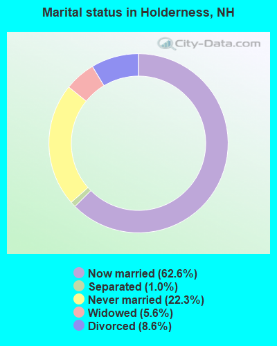
- Never married: 22.3%
- Now married: 62.6%
- Separated: 1.0%
- Widowed: 5.6%
- Divorced: 8.6%
For population 25 years and over in Holderness:
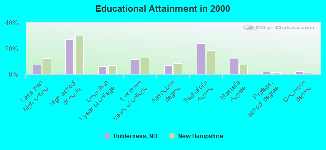
- High school or higher: 92.6%
- Bachelor's degree or higher: 40.4%
- Graduate or professional degree: 16.4%
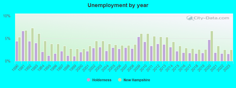
- Unemployed: 2.6%
- Mean travel time to work (commute): 25.5 minutes
| Here: | 10.5 |
| New Hampshire average: | 10.9 |


Graphs represent county-level data. Detailed 2008 Election Results
Religion statistics for Holderness, NH (based on Grafton County data)


| Religion | Adherents | Congregations |
|---|---|---|
| Catholic | 9,503 | 12 |
| Mainline Protestant | 7,832 | 57 |
| Evangelical Protestant | 1,494 | 29 |
| Other | 1,320 | 11 |
| None | 68,969 | - |
Food Environment Statistics:
| Grafton County: | 3.87 / 10,000 pop. |
| State: | 2.14 / 10,000 pop. |
| This county: | 0.23 / 10,000 pop. |
| New Hampshire: | 0.15 / 10,000 pop. |
| Grafton County: | 1.29 / 10,000 pop. |
| New Hampshire: | 1.78 / 10,000 pop. |
| Grafton County: | 6.45 / 10,000 pop. |
| New Hampshire: | 4.02 / 10,000 pop. |
| Here: | 14.41 / 10,000 pop. |
| New Hampshire: | 9.70 / 10,000 pop. |
| Grafton County: | 7.2% |
| New Hampshire: | 7.6% |
| Grafton County: | 22.9% |
| New Hampshire: | 24.4% |
| Grafton County: | 15.9% |
| New Hampshire: | 15.9% |
Businesses in Holderness, NH
- Circle K: 1
Strongest AM radio stations in Holderness:
- WPNH (1300 AM; 5 kW; PLYMOUTH, NH; Owner: NORTHEAST COMMUNICATIONS CORPORATION)
- WEZS (1350 AM; 5 kW; LACONIA, NH; Owner: GARY W. HAMMOND)
- WRKO (680 AM; 50 kW; BOSTON, MA; Owner: ENTERCOM BOSTON LICENSE, LLC)
- WASR (1420 AM; 5 kW; WOLFEBORO, NH; Owner: RADIO WOLFEBORO, INC.)
- WNTK (1020 AM; 10 kW; NEWPORT, NH; Owner: KOOR COMMUNICATIONS, INC.)
- WEEI (850 AM; 50 kW; BOSTON, MA; Owner: ENTERCOM BOSTON LICENSE, LLC)
- WCRN (830 AM; 50 kW; WORCESTER, MA; Owner: CARTER BROADCASTING CORPORATION)
- WGIN (930 AM; 10 kW; ROCHESTER, NH; Owner: CAPSTAR TX LIMITED PARTNERSHIP)
- WNNZ (640 AM; 50 kW; WESTFIELD, MA; Owner: CLEAR CHANNEL BROADCASTING LICENSES, INC.)
- WBZ (1030 AM; 50 kW; BOSTON, MA; Owner: INFINITY BROADCASTING OPERATIONS, INC.)
- WKOX (1200 AM; 50 kW; FRAMINGHAM, MA; Owner: CAPSTAR TX LIMITED PARTNERSHIP)
- WMTW (870 AM; 10 kW; GORHAM, ME; Owner: RADIO PARTNERS OF MAINE, L.P.)
- WBIX (1060 AM; 40 kW; NATICK, MA; Owner: LANGER BROADCASTING CORPORATION)
Strongest FM radio stations in Holderness:
- WSCY (106.9 FM; MOULTONBOROUGH, NH; Owner: NORTHEAST COMMUNICATIONS CORPORATION)
- WPNH-FM (100.1 FM; PLYMOUTH, NH; Owner: NORTHEAST COMMUNICATIONS CORPORATION)
- WVFM (105.7 FM; CAMPTON, NH; Owner: DEVON BROADCASTING COMPANY, INC.)
- WPKQ (103.7 FM; NORTH CONWAY, NH; Owner: CITADEL BROADCASTING COMPANY)
- WHOM (94.9 FM; MT. WASHINGTON, NH; Owner: CITADEL BROADCASTING COMPANY)
- WLKZ (104.9 FM; WOLFEBORO, NH; Owner: TELE-MEDIA COMPANY OF NEW HAMPSHIRE, L.L.C.)
- WLNH-FM (98.3 FM; LACONIA, NH; Owner: WLNH RADIO, INC)
- WHDQ (106.1 FM; CLAREMONT, NH; Owner: GREAT NORTHERN RADIO, L.L.C.)
- WNHI (93.3 FM; BELMONT, NH; Owner: CONCORD BROADCASTING, L.L.C.)
- WEVH (91.3 FM; HANOVER, NH; Owner: NEW HAMPSHIRE PUBLIC RADIO INC)
- WBHG (101.5 FM; MEREDITH, NH; Owner: WLNH RADIO, INC)
- WVPR (89.5 FM; WINDSOR, VT; Owner: VERMONT PUBLIC RADIO)
- WMEA (90.1 FM; PORTLAND, ME; Owner: MAINE PUBLIC BROADCASTING CORPORATION)
- WJJR (98.1 FM; RUTLAND, VT; Owner: 6 JOHNSON ROAD LICENSES, INC.)
- WZRT (97.1 FM; RUTLAND, VT; Owner: CAPSTAR TX LIMITED PARTNERSHIP)
- WEBK (105.3 FM; KILLINGTON, VT; Owner: 6 JOHNSON ROAD LICENSES, INC.)
- WFTN-FM (94.1 FM; FRANKLIN, NH; Owner: NORTHEAST COMMUNICATIONS CORPORATION)
- WGLV (91.7 FM; WOODSTOCK, VT; Owner: CHRISTIAN MINISTRIES INC)
- WHDQ-FM1 (106.1 FM; RUTLAND, VT; Owner: GREAT NORTHERN RADIO, L.L.C.)
- WGMT (97.7 FM; LYNDON, VT; Owner: VERMONT BROADCAST ASSOCIATES, INC.)
TV broadcast stations around Holderness:
- WMTW-TV (Channel 8; POLAND SPRING, ME; Owner: WMTW BROADCAST GROUP, LLC)
- WMEA-TV (Channel 26; BIDDEFORD, ME; Owner: MAINE PUBLIC BROADCASTING CORP.)
- WCSH (Channel 6; PORTLAND, ME; Owner: PACIFIC AND SOUTHERN COMPANY, INC.)
- W15BK (Channel 15; HANOVER, NH; Owner: UNIVERSITY OF NEW HAMPSHIRE)
- Holderness, New Hampshire
- Fatal accident count9
- Vehicles involved in fatal accidents14
- Fatal accidents involving drunk persons:6
- Fatalities10
- Persons involved in fatal accidents23
- Pedestrians involved in fatal accidents2
- New Hampshire average
- Fatal accident count1066
- Vehicles involved in fatal accidents1530
- Fatal accidents involving drunk persons348
- Fatalities1154
- Persons involved in fatal accidents2427
- Pedestrians involved in fatal accidents124
- National Bridge Inventory (NBI) Statistics
- 4Number of bridges
- 69ft / 20.6mTotal length
- $12,568,000Total costs
- 30,738Total average daily traffic
- 2,282Total average daily truck traffic
- 45,489Total future (year 2042) average daily traffic
FCC Registered Cell Phone Towers:
1 (See the full list of FCC Registered Cell Phone Towers in Holderness)FCC Registered Antenna Towers:
10 (See the full list of FCC Registered Antenna Towers)FCC Registered Broadcast Land Mobile Towers:
2- Rt 25 Fire Sta (Lat: 43.730639 Lon: -71.591472), Call Sign: KRB415, Licensee ID: L00047784,
Assigned Frequencies: 33.9000 MHz, Grant Date: 11/17/1998, Expiration Date: 02/13/2004, Cancellation Date: 11/12/2003, Registrant: Holderness, Town Of, Fire Dept, Holderness, NH 03245, Phone: (603) 536-3391
- Fire Station Rt 3 (Lat: 43.718139 Lon: -71.590917), Call Sign: KGX951, Licensee ID: L00008549,
Assigned Frequencies: 31.9000 MHz, Grant Date: 08/08/2001, Expiration Date: 09/18/2011, Cancellation Date: 11/19/2003, Registrant: The State Of New Hampshire, Department Of Resources And Economic Development, 172 Pembroke Road, Concord, NH 03302-1856, Phone: (603) 271-2217, Fax: (603) 271-6488, Email:
FCC Registered Amateur Radio Licenses:
15 (See the full list of FCC Registered Amateur Radio Licenses in Holderness)FAA Registered Aircraft:
3- Aircraft: NORTH AMERICAN/AERO CLASSICS P-51D (Category: Land, Weight: Up to 12,499 Pounds, Speed: 277 mph), Engine: ROLLS-ROYC V-1650-7 (1180 HP) (Reciprocating)
N-Number: 251BP, N251BP, N-251BP, Serial Number: 4484753, Year manufactured: 1944, Airworthiness Date: 06/23/2009, Certificate Issue Date: 12/04/2009
Registrant (LLC): Cielos LLC, Po Box 683, Holderness, NH 03245 - Aircraft: PIPER PA-31-325 (Category: Land, Engines: 2, Seats: 8, Weight: Up to 12,499 Pounds, Speed: 162 mph), Engine: LYCOMING TI0-540 SER (310 HP) (Reciprocating)
N-Number: 800DK, N800DK, N-800DK, Serial Number: 31-7612110, Year manufactured: 1976, Airworthiness Date: 11/03/1976, Certificate Issue Date: 11/02/2016
Registrant (LLC): Influent Medical LLC, Po Box 452, Holderness, NH 03245 - Aircraft: PIPER PA-32-301 (Category: Land, Seats: 7, Weight: Up to 12,499 Pounds), Engine: LYCOMING IO-540 SER (300 HP) (Reciprocating)
N-Number: 8461C, N8461C, N-8461C, Serial Number: 32-8206006, Year manufactured: 1981, Airworthiness Date: 10/15/1981, Certificate Issue Date: 03/27/2015
Registrant (Individual): Max L Dannis, 313 Mount Prospect Rd, Holderness, NH 03245
2002 - 2018 National Fire Incident Reporting System (NFIRS) incidents
- Fire incident types reported to NFIRS in Holderness, NH
- 13656.7%Structure Fires
- 7029.2%Outside Fires
- 2510.4%Mobile Property/Vehicle Fires
- 93.8%Other
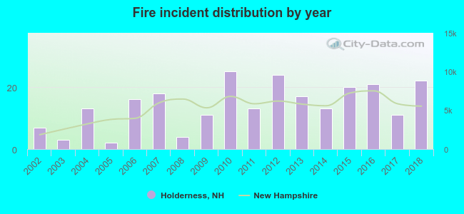 According to the data from the years 2002 - 2018 the average number of fires per year is 14. The highest number of fires - 25 took place in 2010, and the least - 2 in 2005. The data has a growing trend.
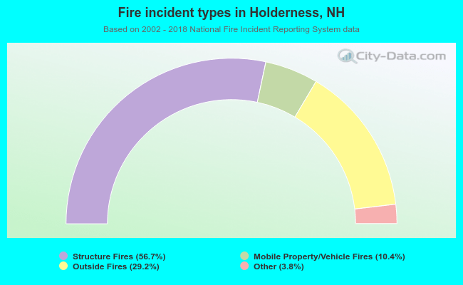 When looking into fire subcategories, the most reports belonged to: Structure Fires (56.7%), and Outside Fires (29.2%).
- 75.4%Fuel oil, kerosene, etc.
- 13.1%Wood
- 6.9%Bottled, tank, or LP gas
- 3.6%Electricity
- 0.7%Utility gas
- 0.3%Other fuel
- 69.3%Fuel oil, kerosene, etc.
- 14.7%Bottled, tank, or LP gas
- 10.4%Electricity
- 4.3%Wood
- 1.2%Coal or coke
Holderness compared to New Hampshire state average:
- Unemployed percentage significantly below state average.
- Black race population percentage below state average.
- Hispanic race population percentage significantly below state average.
- Foreign-born population percentage significantly below state average.
- Length of stay since moving in significantly above state average.
- Number of rooms per house significantly below state average.
- House age significantly below state average.

|
|
Total of 16 patent applications in 2008-2024.