Hunting Valley, Ohio
Submit your own pictures of this village and show them to the world
(3.4% for White Non-Hispanic residents, 14.3% for other race residents, 14.4% for two or more races residents)
Detailed information about poverty and poor residents in Hunting Valley, OH
Full-time law enforcement employees in 2020, including police officers: 11 (11 officers - 11 male; 0 female).
| Officers per 1,000 residents here: | 15.36 |
| Ohio average: | 2.24 |
 Recent articles from our blog. Our writers, many of them Ph.D. graduates or candidates, create easy-to-read articles on a wide variety of topics.
| Here: | 3.2% |
| Ohio: | 3.1% |
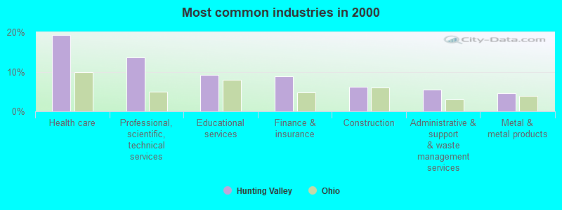
- Health care (19.2%)
- Professional, scientific, technical services (13.7%)
- Educational services (9.1%)
- Finance & insurance (8.8%)
- Construction (6.2%)
- Administrative & support & waste management services (5.5%)
- Metal & metal products (4.6%)
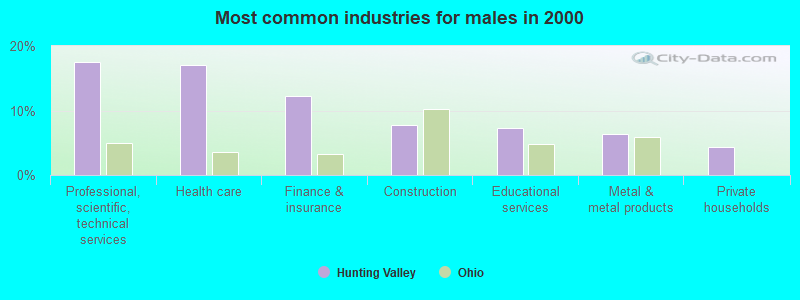
- Professional, scientific, technical services (17.6%)
- Health care (17.1%)
- Finance & insurance (12.2%)
- Construction (7.8%)
- Educational services (7.3%)
- Metal & metal products (6.3%)
- Private households (4.4%)
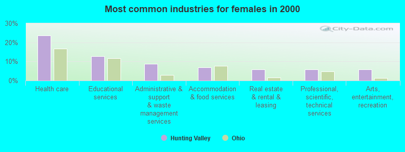
- Health care (23.5%)
- Educational services (12.7%)
- Administrative & support & waste management services (8.8%)
- Accommodation & food services (6.9%)
- Real estate & rental & leasing (5.9%)
- Professional, scientific, technical services (5.9%)
- Arts, entertainment, recreation (5.9%)
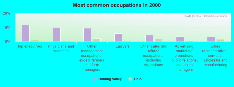
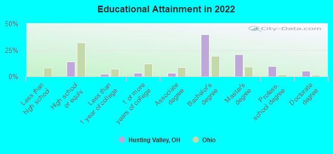
- Top executives (11.7%)
- Physicians and surgeons (10.1%)
- Other management occupations, except farmers and farm managers (9.4%)
- Lawyers (5.9%)
- Other sales and related occupations, including supervisors (4.6%)
- Advertising, marketing, promotions, public relations, and sales managers (3.6%)
- Sales representatives, services, wholesale and manufacturing (3.3%)
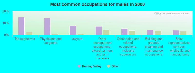
- Top executives (15.1%)
- Physicians and surgeons (14.1%)
- Lawyers (7.8%)
- Other management occupations, except farmers and farm managers (7.3%)
- Other sales and related occupations, including supervisors (5.4%)
- Building and grounds cleaning and maintenance occupations (4.4%)
- Sales representatives, services, wholesale and manufacturing (3.9%)
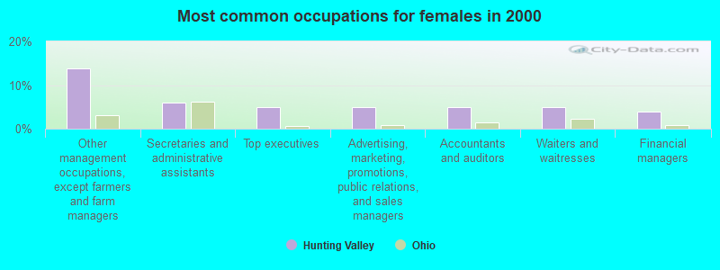
- Other management occupations, except farmers and farm managers (13.7%)
- Secretaries and administrative assistants (5.9%)
- Top executives (4.9%)
- Advertising, marketing, promotions, public relations, and sales managers (4.9%)
- Accountants and auditors (4.9%)
- Waiters and waitresses (4.9%)
- Financial managers (3.9%)
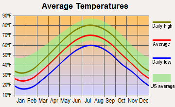
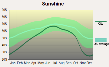
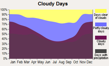
Average climate in Hunting Valley, Ohio
Based on data reported by over 4,000 weather stations
(lower is better)
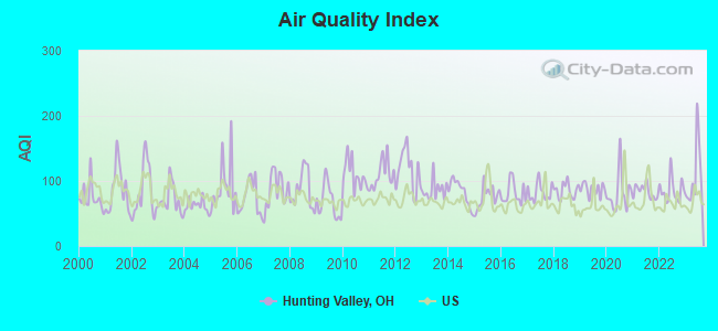
Air Quality Index (AQI) level in 2023 was 108. This is significantly worse than average.
| City: | 108 |
| U.S.: | 73 |
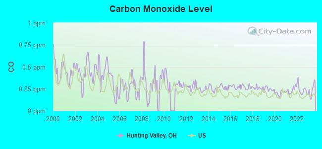
Carbon Monoxide (CO) [ppm] level in 2023 was 0.235. This is about average. Closest monitor was 9.3 miles away from the city center.
| City: | 0.235 |
| U.S.: | 0.251 |
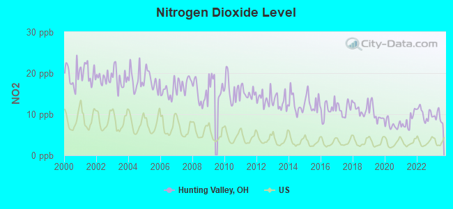
Nitrogen Dioxide (NO2) [ppb] level in 2023 was 9.32. This is significantly worse than average. Closest monitor was 5.0 miles away from the city center.
| City: | 9.32 |
| U.S.: | 5.11 |
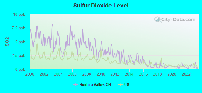
Sulfur Dioxide (SO2) [ppb] level in 2023 was 0.491. This is significantly better than average. Closest monitor was 5.0 miles away from the city center.
| City: | 0.491 |
| U.S.: | 1.515 |
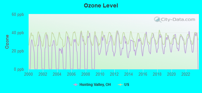
Ozone [ppb] level in 2023 was 34.1. This is about average. Closest monitor was 10.5 miles away from the city center.
| City: | 34.1 |
| U.S.: | 33.3 |
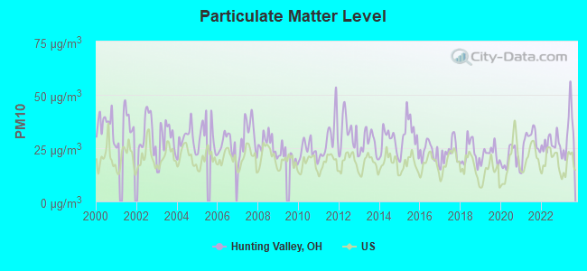
Particulate Matter (PM10) [µg/m3] level in 2023 was 32.2. This is significantly worse than average. Closest monitor was 13.2 miles away from the city center.
| City: | 32.2 |
| U.S.: | 19.2 |
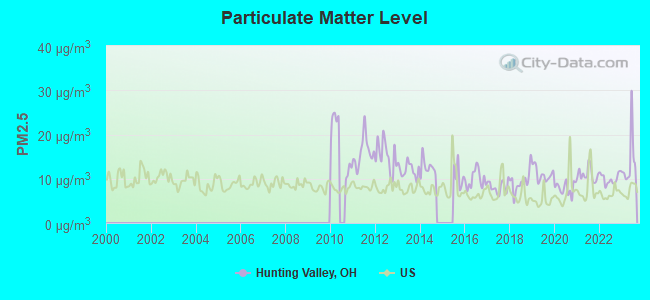
Particulate Matter (PM2.5) [µg/m3] level in 2023 was 13.9. This is significantly worse than average. Closest monitor was 9.3 miles away from the city center.
| City: | 13.9 |
| U.S.: | 8.1 |
Tornado activity:
Hunting Valley-area historical tornado activity is slightly below Ohio state average. It is 7% smaller than the overall U.S. average.
On 5/31/1985, a category F5 (max. wind speeds 261-318 mph) tornado 23.1 miles away from the Hunting Valley village center killed 18 people and injured 310 people and caused between $50,000,000 and $500,000,000 in damages.
On 6/8/1953, a category F4 (max. wind speeds 207-260 mph) tornado 16.6 miles away from the village center killed 17 people and injured 379 people.
Earthquake activity:
Hunting Valley-area historical earthquake activity is significantly above Ohio state average. It is 52% smaller than the overall U.S. average.On 9/25/1998 at 19:52:52, a magnitude 5.2 (4.8 MB, 4.3 MS, 5.2 LG, 4.5 MW, Depth: 3.1 mi, Class: Moderate, Intensity: VI - VII) earthquake occurred 52.1 miles away from the city center
On 1/31/1986 at 16:46:43, a magnitude 5.0 (5.0 MB) earthquake occurred 15.2 miles away from the city center
On 8/23/2011 at 17:51:04, a magnitude 5.8 (5.8 MW, Depth: 3.7 mi) earthquake occurred 307.9 miles away from Hunting Valley center
On 6/10/2019 at 14:50:45, a magnitude 4.0 (4.0 MB, Depth: 1.2 mi, Class: Light, Intensity: IV - V) earthquake occurred 14.4 miles away from Hunting Valley center
On 7/27/1980 at 18:52:21, a magnitude 5.2 (5.1 MB, 4.7 MS, 5.0 UK, 5.2 UK) earthquake occurred 263.4 miles away from the city center
On 12/31/2011 at 20:05:01, a magnitude 4.0 (4.0 ML, Depth: 3.1 mi) earthquake occurred 44.6 miles away from the city center
Magnitude types: regional Lg-wave magnitude (LG), body-wave magnitude (MB), local magnitude (ML), surface-wave magnitude (MS), moment magnitude (MW)
Natural disasters:
The number of natural disasters in Cuyahoga County (16) is near the US average (15).Major Disasters (Presidential) Declared: 12
Emergencies Declared: 3
Causes of natural disasters: Storms: 9, Floods: 8, Tornadoes: 7, Winds: 3, Hurricanes: 2, Blizzard: 1, Heavy Rain: 1, Power Outage: 1, Snowstorm: 1, Tropical Storm: 1, Other: 1 (Note: some incidents may be assigned to more than one category).
Hospitals and medical centers near Hunting Valley:
- WINDSOR HOSPITAL (Hospital, about 3 miles away; CHAGRIN FALLS, OH)
- HAMLET MANOR (Nursing Home, about 4 miles away; CHAGRIN FALLS, OH)
- VERITACARE (Home Health Center, about 4 miles away; MAYFIELD HEIGHTS, OH)
- METZENBAUM RESIDENCE (Hospital, about 4 miles away; CHESTERLAND, OH)
- SAINT ANGELA CENTER (Nursing Home, about 4 miles away; PEPPER PIKE, OH)
- HILLCREST HOSPITAL Acute Care Hospitals (about 4 miles away; MAYFIELD HEIGHTS, OH)
- MANORCARE HEALTH SERVICES-MAYFIELD HTS (Nursing Home, about 4 miles away; MAYFIELD HEIGHTS, OH)
Amtrak station near Hunting Valley:
Colleges/universities with over 2000 students nearest to Hunting Valley:
- John Carroll University (about 7 miles; University Heights, OH; Full-time enrollment: 3,546)
- Case Western Reserve University (about 11 miles; Cleveland, OH; FT enrollment: 7,034)
- Lakeland Community College (about 12 miles; Kirtland, OH; FT enrollment: 6,170)
- Cuyahoga Community College District (about 14 miles; Cleveland, OH; FT enrollment: 20,271)
- Cleveland State University (about 15 miles; Cleveland, OH; FT enrollment: 14,161)
- Kent State University at Kent (about 23 miles; Kent, OH; FT enrollment: 25,431)
- Baldwin Wallace University (about 25 miles; Berea, OH; FT enrollment: 3,699)
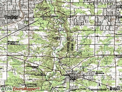
Points of interest:
Notable locations in Hunting Valley: Daisy Hill Greenhouses (A), Hunting Valley Village Hall (B). Display/hide their locations on the map
Creeks: Griswold Creek (A), Creek Chub Run (B). Display/hide their locations on the map
Park in Hunting Valley: Chagrin State Scenic River (1). Display/hide its location on the map
| This village: | 2.5 people |
| Ohio: | 2.4 people |
| This village: | 78.0% |
| Whole state: | 65.0% |
| This village: | 2.2% |
| Whole state: | 6.8% |
Likely homosexual households (counted as self-reported same-sex unmarried-partner households)
- Lesbian couples: 0.0% of all households
- Gay men: 0.7% of all households
| Here: | 8.8 |
| Ohio average: | 11.0 |
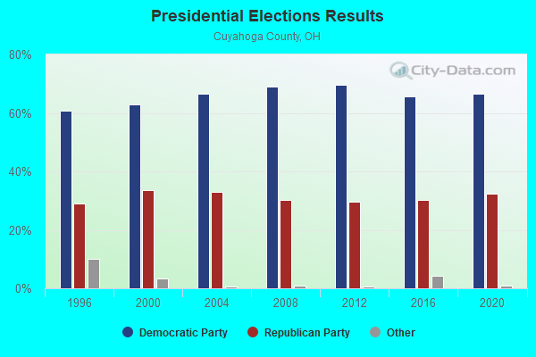
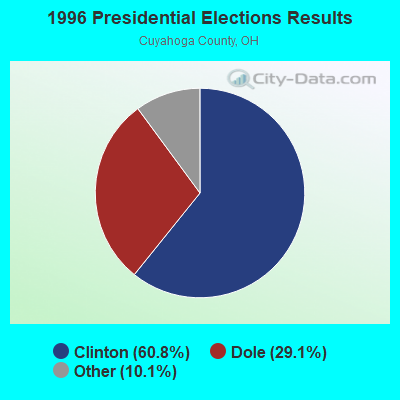
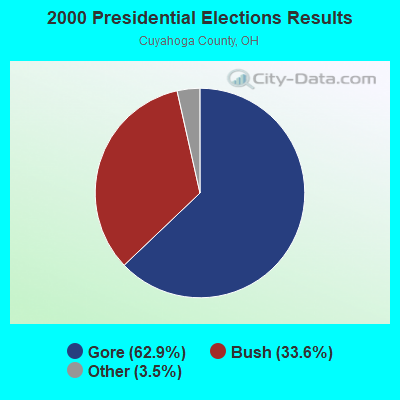
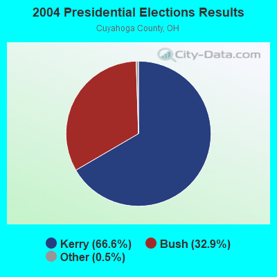
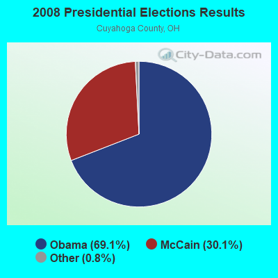
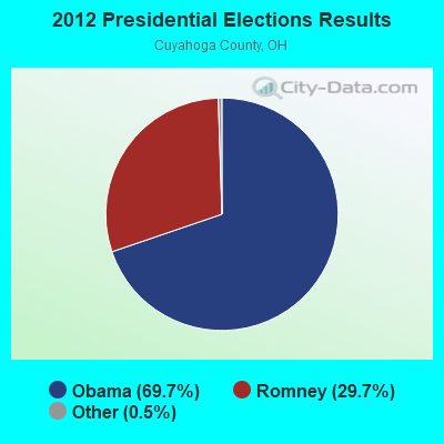
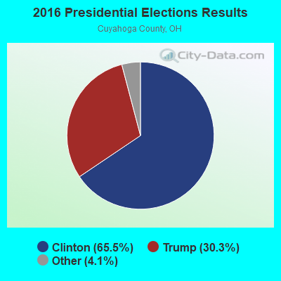
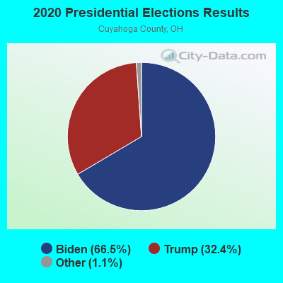
Graphs represent county-level data. Detailed 2008 Election Results
Political contributions by individuals in Hunting Valley, OH
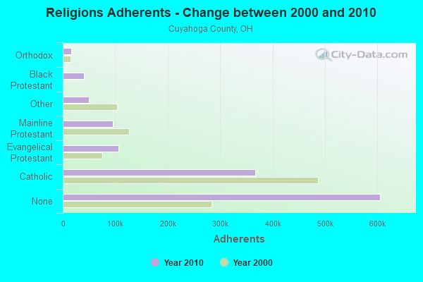
Religion statistics for Hunting Valley, OH (based on Cuyahoga County data)
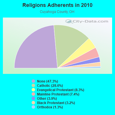
| Religion | Adherents | Congregations |
|---|---|---|
| Catholic | 366,464 | 110 |
| Evangelical Protestant | 106,477 | 326 |
| Mainline Protestant | 94,977 | 233 |
| Other | 49,641 | 126 |
| Black Protestant | 40,776 | 129 |
| Orthodox | 16,456 | 31 |
| None | 605,331 | - |
Food Environment Statistics:
| Here: | 2.33 / 10,000 pop. |
| State: | 1.89 / 10,000 pop. |
| Cuyahoga County: | 0.05 / 10,000 pop. |
| State: | 0.13 / 10,000 pop. |
| Cuyahoga County: | 1.68 / 10,000 pop. |
| State: | 1.25 / 10,000 pop. |
| Here: | 2.26 / 10,000 pop. |
| State: | 2.93 / 10,000 pop. |
| Cuyahoga County: | 6.88 / 10,000 pop. |
| State: | 6.25 / 10,000 pop. |
| Cuyahoga County: | 10.8% |
| State: | 10.3% |
| Cuyahoga County: | 28.3% |
| Ohio: | 29.1% |
| This county: | 10.4% |
| Ohio: | 11.9% |
Health and Nutrition:
| Hunting Valley: | 62.7% |
| Ohio: | 50.4% |
| Hunting Valley: | 63.6% |
| Ohio: | 47.8% |
| This city: | 27.7 |
| State: | 28.7 |
| Hunting Valley: | 14.9% |
| Ohio: | 20.6% |
| Hunting Valley: | 5.2% |
| State: | 10.4% |
| Hunting Valley: | 7.1 |
| State: | 6.8 |
| This city: | 36.8% |
| Ohio: | 34.3% |
| This city: | 66.3% |
| Ohio: | 57.0% |
| Hunting Valley: | 79.5% |
| State: | 79.1% |
More about Health and Nutrition of Hunting Valley, OH Residents
| Local government employment and payroll (March 2022) | |||||
| Function | Full-time employees | Monthly full-time payroll | Average yearly full-time wage | Part-time employees | Monthly part-time payroll |
|---|---|---|---|---|---|
| Police Protection - Officers | 11 | $85,200 | $92,945 | 4 | $3,332 |
| Streets and Highways | 4 | $25,166 | $75,498 | 1 | $376 |
| Other Government Administration | 3 | $20,878 | $83,512 | 0 | $0 |
| Judicial and Legal | 0 | $0 | 1 | $1,757 | |
| Financial Administration | 0 | $0 | 1 | $1,731 | |
| Totals for Government | 18 | $131,243 | $87,495 | 7 | $7,196 |
Hunting Valley government finances - Expenditure in 2017 (per resident):
- Construction - Natural Resources - Other: $207,000 ($271.30)
Regular Highways: $101,000 ($132.37)
Solid Waste Management: $66,000 ($86.50)
- Current Operations - Police Protection: $1,592,000 ($2086.50)
Regular Highways: $759,000 ($994.76)
Financial Administration: $293,000 ($384.01)
Central Staff Services: $234,000 ($306.68)
Protective Inspection and Regulation - Other: $210,000 ($275.23)
General Public Buildings: $207,000 ($271.30)
Local Fire Protection: $205,000 ($268.68)
Solid Waste Management: $137,000 ($179.55)
General - Other: $18,000 ($23.59)
Parks and Recreation: $13,000 ($17.04)
Health - Other: $1,000 ($1.31)
- General - Interest on Debt: $57,000 ($74.71)
- Intergovernmental to Local - Other - Police Protection: $103,000 ($134.99)
Other - Financial Administration: $45,000 ($58.98)
Other - Health - Other: $10,000 ($13.11)
Other - Judicial and Legal Services: $3,000 ($3.93)
Other - Central Staff Services: $2,000 ($2.62)
Other - Correctional Institutions: $1,000 ($1.31)
- Intergovernmental to State - Police Protection: $1,000 ($1.31)
- Other Capital Outlay - Natural Resources - Other: $98,000 ($128.44)
Police Protection: $69,000 ($90.43)
Central Staff Services: $26,000 ($34.08)
General Public Building: $23,000 ($30.14)
Regular Highways: $9,000 ($11.80)
Financial Administration: $2,000 ($2.62)
- Total Salaries and Wages: $1,603,000 ($2100.92)
Hunting Valley government finances - Revenue in 2017 (per resident):
- Charges - Other: $53,000 ($69.46)
- Local Intergovernmental - Other: $3,232,000 ($4235.91)
General Local Government Support: $32,000 ($41.94)
Highways: $7,000 ($9.17)
- Miscellaneous - Rents: $123,000 ($161.21)
Interest Earnings: $110,000 ($144.17)
General Revenue - Other: $87,000 ($114.02)
Fines and Forfeits: $4,000 ($5.24)
- State Intergovernmental - Highways: $12,000 ($15.73)
General Local Government Support: $3,000 ($3.93)
- Tax - Property: $1,034,000 ($1355.18)
Alcoholic Beverage License: $116,000 ($152.03)
Hunting Valley government finances - Cash and Securities in 2017 (per resident):
- Other Funds - Cash and Securities: $12,020,000 ($15753.60)
4.02% of this county's 2021 resident taxpayers lived in other counties in 2020 ($66,006 average adjusted gross income)
| Here: | 4.02% |
| Ohio average: | 5.68% |
0.02% of residents moved from foreign countries ($135 average AGI)
Cuyahoga County: 0.02% Ohio average: 0.01%
Top counties from which taxpayers relocated into this county between 2020 and 2021:
| from Lorain County, OH | |
| from Summit County, OH | |
| from Lake County, OH |
5.02% of this county's 2020 resident taxpayers moved to other counties in 2021 ($88,842 average adjusted gross income)
| Here: | 5.02% |
| Ohio average: | 5.79% |
0.01% of residents moved to foreign countries ($120 average AGI)
Cuyahoga County: 0.01% Ohio average: 0.01%
Top counties to which taxpayers relocated from this county between 2020 and 2021:
| to Lorain County, OH | |
| to Summit County, OH | |
| to Lake County, OH |
Strongest AM radio stations in Hunting Valley:
- WTAM (1100 AM; 50 kW; CLEVELAND, OH; Owner: JACOR BROADCASTING CORPORATION)
- WKNR (850 AM; 50 kW; CLEVELAND, OH; Owner: CARON BROADCASTING, INC.)
- WHK (1220 AM; 50 kW; CLEVELAND, OH; Owner: CARON BROADCASTING, INC.)
- WWMK (1260 AM; 10 kW; CLEVELAND, OH; Owner: ABC, INC.)
- WRMR (1420 AM; 5 kW; CLEVELAND, OH; Owner: CLEVELAND CLASSICAL RADIO, LLC)
- WCUE (1150 AM; 5 kW; CUYAHOGA FALLS, OH; Owner: FAMILY STATIONS, INC.)
- WERE (1300 AM; 5 kW; CLEVELAND, OH)
- WHLO (640 AM; 5 kW; AKRON, OH; Owner: CLEAR CHANNEL BROADCASTING LICENSES, INC.)
- WTOU (1350 AM; 5 kW; AKRON, OH)
- WHBC (1480 AM; 15 kW; CANTON, OH; Owner: NM LICENSING, LLC)
- WJMO (1490 AM; 1 kW; CLEVELAND HEIGHTS, OH; Owner: BLUE CHIP BROADCASTING LICENSES, LTD.)
- WJR (760 AM; 50 kW; DETROIT, MI; Owner: ABC, INC.)
- KDKA (1020 AM; 50 kW; PITTSBURGH, PA; Owner: INFINITY BROADCASTING OPERATIONS, INC.)
Strongest FM radio stations in Hunting Valley:
- WENZ (107.9 FM; CLEVELAND, OH; Owner: RADIO ONE LICENSES, LLC)
- WFHM-FM (95.5 FM; CLEVELAND, OH; Owner: SCA LICENSE CORPORATION)
- WXTM (92.3 FM; CLEVELAND HEIGHTS, OH; Owner: INFINITY RADIO OPERATIONS INC.)
- WKHR (91.5 FM; BAINBRIDGE, OH; Owner: KENSTON LOCAL SCHOOL DISTRICT)
- WMJI (105.7 FM; CLEVELAND, OH; Owner: CITICASTERS LICENSES, L.P.)
- WJCU (88.7 FM; UNIVERSITY HEIGHTS, OH; Owner: JOHN CARROLL UNIVERSITY)
- WDOK (102.1 FM; CLEVELAND, OH; Owner: INFINITY RADIO OPERATIONS INC.)
- WQAL (104.1 FM; CLEVELAND, OH; Owner: INFINITY RADIO OPERATIONS INC.)
- WMVX (106.5 FM; CLEVELAND, OH; Owner: JACOR BROADCASTING CORPORATION)
- WNCX (98.5 FM; CLEVELAND, OH; Owner: INFINITY RADIO OF CLEVELAND INC.)
- WMMS (100.7 FM; CLEVELAND, OH; Owner: CITICASTERS LICENSES, L.P.)
- WCRF-FM (103.3 FM; CLEVELAND, OH; Owner: THE MOODY BIBLE INSTITUTE OF CHICAGO)
- WRUW-FM (91.1 FM; CLEVELAND, OH; Owner: CASE WESTERN RESERVE UNIVERSITY)
- WZAK (93.1 FM; CLEVELAND, OH; Owner: RADIO ONE LICENSES, LLC)
- WAKS (96.5 FM; AKRON, OH; Owner: CAPSTAR TX LIMITED PARTNERSHIP)
- WCPN (90.3 FM; CLEVELAND, OH; Owner: IDEASTREAM)
- WGAR-FM (99.5 FM; CLEVELAND, OH; Owner: CITICASTERS LICENSES, L.P.)
- WKSU-FM (89.7 FM; KENT, OH; Owner: KENT STATE UNIVERSITY)
- WONE-FM (97.5 FM; AKRON, OH; Owner: RUBBER CITY RADIO GROUP, INC.)
- WQMX (94.9 FM; MEDINA, OH; Owner: RUBBER CITY RADIO GROUP, INC)
TV broadcast stations around Hunting Valley:
- WXOX-LP (Channel 65; CLEVELAND, OH; Owner: VENTURE TECHNOLOGIES GROUP, LLC)
- W53AX (Channel 53; CLEVELAND, OH; Owner: WORD OF GOD FELLOWSHIP, INC.)
- W51BI (Channel 51; KIRTLAND, OH; Owner: TRINITY BROADCASTING NETWORK)
- WKYC-TV (Channel 3; CLEVELAND, OH; Owner: WKYC-TV, INC.)
- WOIO (Channel 19; SHAKER HEIGHTS, OH; Owner: RAYCOM NATIONAL, INC.)
- WBNX-TV (Channel 55; AKRON, OH; Owner: WINSTON BROADCASTING NETWORK, INC.)
- W35AX (Channel 35; CLEVELAND, OH; Owner: MEDIA-COM TELEVISION, INC.)
- WQHS-TV (Channel 61; CLEVELAND, OH; Owner: UNIVISION CLEVELAND LLC)
- WEWS-TV (Channel 5; CLEVELAND, OH; Owner: SCRIPPS HOWARD BROADCASTING COMPANY)
- WRAP-CA (Channel 32; CLEVELAND, OH; Owner: COMMERCIAL BROADCASTING CORP.)
- WUAB (Channel 43; LORAIN, OH; Owner: RAYCOM NATIONAL, INC.)
- WJW (Channel 8; CLEVELAND, OH; Owner: WJW LICENSE, INC.)
- WVIZ (Channel 25; CLEVELAND, OH; Owner: IDEASTREAM)
- WVPX (Channel 23; AKRON, OH; Owner: PAXSON AKRON LICENSE, INC.)
- WEAO (Channel 49; AKRON, OH; Owner: NORTHEASTERN EDUCATIONAL TELEVISION OF OHIO, INC.)
- WKBN-TV (Channel 27; YOUNGSTOWN, OH; Owner: PIEDMONT TELEVISION OF YOUNGSTOWN LICENSE LLC)
- WAKN-LP (Channel 11; AKRON, OH; Owner: AKRON TELEVISION, INC.)
- WDLI (Channel 17; CANTON, OH; Owner: TRINITY BROADCASTING NETWORK, INC.)
- WOAC (Channel 67; CANTON, OH; Owner: WRAY, INC.)
- WAOH-LP (Channel 29; AKRON, OH; Owner: MEDIA-COM TELEVISION, INC.)
Hunting Valley fatal accident list:
Sep 30, 2014 01:33 PM, Sr-87 South Woodland Rd, Lat: 41.459542, Lon: -81.396297, Vehicles: 2, Persons: 3, Fatalities: 1
Sep 16, 2008 12:50 AM, Chagrin-River, Lat: 41.470190, Lon: -81.408950, Vehicles: 1, Persons: 1, Fatalities: 1
Oct 24, 2002 05:01 PM, Chagrin River Rd, Vehicles: 1, Persons: 1, Fatalities: 1
Dec 9, 1996 07:00 AM, Som Center, Vehicles: 2, Persons: 3, Fatalities: 1
May 20, 1983 01:09 PM, 91, Vehicles: 1, Persons: 3, Fatalities: 2
- National Bridge Inventory (NBI) Statistics
- 8Number of bridges
- 59ft / 18.2mTotal length
- $233,000Total costs
- 34,212Total average daily traffic
- 1,926Total average daily truck traffic
- 47,486Total future (year 2035) average daily traffic
FCC Registered Cell Phone Towers:
1- 38251 Fairmont Boulevard (Lat: 41.492111 Lon: -81.407139), Type: Pole, Structure height: 57.9 m, Overall height: 60.7 m, Call Sign: KNKA248
Assigned Frequencies: 880.020 MHz, 880.020 MHz, 880.020 MHz, 835.020 MHz, 835.020 MHz, 835.020 MHz, 891.510 MHz, 891.510 MHz, 891.510 MHz, 846.510 MHz, 846.510 MHz, 846.510 MHzGrant Date: 05/01/2015, Expiration Date: 05/15/2025, Certifier: Gregory M RomanoRegistrant: Verizon Wireless, 5055 North Point Pkwy, Np2ne Network Engineering, Alpharetta, GA 30022, Phone: (770) 797-1070, Fax: (202) 783-5851, Email:
FCC Registered Microwave Towers:
3- CLE0511, 38251a Fairmount Rd. (Lat: 41.491806 Lon: -81.407167), Type: Tower, Structure height: 57.9 m, Call Sign: WQBJ815, Licensee ID: L00608820,
Assigned Frequencies: 17880.0 MHz, 18120.0 MHz, Grant Date: 10/21/2004, Expiration Date: 10/21/2014, Cancellation Date: 05/26/2006, Certifier: Eric M Botto, Registrant: Fibertower Corporation, 185 Berry Street, Suite 4800, San Francisco, CA 94107, Phone: (415) 659-3500, Fax: (415) 659-0007, Email:
- CLE0512, 44505 B South Woodland (Lat: 41.458083 Lon: -81.404639), Type: Tower, Structure height: 54.9 m, Call Sign: WQBL529, Licensee ID: L00608820,
Assigned Frequencies: 19680.0 MHz, Grant Date: 11/01/2004, Expiration Date: 11/01/2014, Cancellation Date: 04/17/2006, Certifier: Eric M Botto, Registrant: Fibertower Corporation, 185 Berry Street, Suite 4800, San Francisco, CA 94107, Phone: (415) 659-3500, Fax: (415) 659-0007, Email:
- HUNTING VLY, 38251 Fairmont Blvd (Lat: 41.491778 Lon: -81.407167), Type: Mtower, Structure height: 54.6 m, Overall height: 57.6 m, Call Sign: WQQM250, Licensee ID: L00061544,
Assigned Frequencies: 10835.0 MHz, 10835.0 MHz, 10835.0 MHz, 10835.0 MHz, Grant Date: 01/04/2023, Expiration Date: 01/24/2033, Certifier: Brad A Handke, Registrant: City Of Cleveland, 1300 Lakeside Ave E., Cleveland, OH 44114, Phone: (216) 664-3259, Fax: (216) 664-3996, Email:
FCC Registered Amateur Radio Licenses:
6- Call Sign: K8RAC, Previous Call Sign: N8GHX, Licensee ID: L00245475, Grant Date: 08/03/2017, Expiration Date: 10/14/2027, Registrant: Randall A Cole, 14230 County Line Rd, Hunting Valley, OH 44022
- Call Sign: N8DJX, Licensee ID: L00873047, Grant Date: 06/04/2014, Expiration Date: 08/30/2024, Certifier: Bruce M Bacik, Registrant: Bruce M Bacik, 35200 Fairmount Blvd, Hunting Valley, OH 44022
- Call Sign: N8NGX, Previous Call Sign: KB8KUP, Grant Date: 01/22/1991, Expiration Date: 01/22/2001, Cancellation Date: 01/23/2003, Registrant: Herbert J Venables, 36000 Shaker Blvd, Hunting Valley, OH 44022
- Call Sign: W8JVO, Licensee ID: L00261775, Grant Date: 08/14/1996, Expiration Date: 08/14/2006, Cancellation Date: 08/04/2000, Registrant: Robert M Zollinger Jr, 13650 County Line Rd, Hunting Valley, OH 44022
- Call Sign: KD8BWF, Licensee ID: L01041096, Grant Date: 07/15/2005, Expiration Date: 07/15/2015, Cancellation Date: 07/18/2017, Certifier: Tamas Geczy, Registrant: Tamas Geczy, 38075 Shaker Blvd, Hunting Valley, OH 44022
- Call Sign: KE8OUN, Licensee ID: L02350889, Grant Date: 07/02/2020, Expiration Date: 07/02/2030, Certifier: Harry P Hawkes Iii, Registrant: Harry P Hawkes Iii, 14975 County Line Rd, Hunting Valley, OH 44022-6801
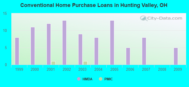
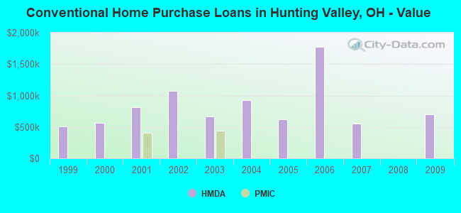
| Home Mortgage Disclosure Act Aggregated Statistics For Year 2009 (Based on 1 full tract) | ||||||||
| B) Conventional Home Purchase Loans | C) Refinancings | D) Home Improvement Loans | F) Non-occupant Loans on < 5 Family Dwellings (A B C & D) | |||||
|---|---|---|---|---|---|---|---|---|
| Number | Average Value | Number | Average Value | Number | Average Value | Number | Average Value | |
| LOANS ORIGINATED | 5 | $695,800 | 13 | $503,462 | 0 | $0 | 0 | $0 |
| APPLICATIONS APPROVED, NOT ACCEPTED | 1 | $417,000 | 2 | $999,500 | 0 | $0 | 0 | $0 |
| APPLICATIONS DENIED | 2 | $760,000 | 5 | $765,600 | 1 | $2,000,000 | 0 | $0 |
| APPLICATIONS WITHDRAWN | 2 | $1,040,000 | 2 | $330,500 | 0 | $0 | 1 | $250,000 |
| FILES CLOSED FOR INCOMPLETENESS | 0 | $0 | 0 | $0 | 0 | $0 | 0 | $0 |
Detailed HMDA statistics for the following Tracts: 1947.00
| Private Mortgage Insurance Companies Aggregated Statistics For Year 2003 (Based on 1 full tract) | ||
| A) Conventional Home Purchase Loans | ||
|---|---|---|
| Number | Average Value | |
| LOANS ORIGINATED | 1 | $437,000 |
| APPLICATIONS APPROVED, NOT ACCEPTED | 0 | $0 |
| APPLICATIONS DENIED | 0 | $0 |
| APPLICATIONS WITHDRAWN | 0 | $0 |
| FILES CLOSED FOR INCOMPLETENESS | 0 | $0 |
Detailed PMIC statistics for the following Tracts: 1947.00
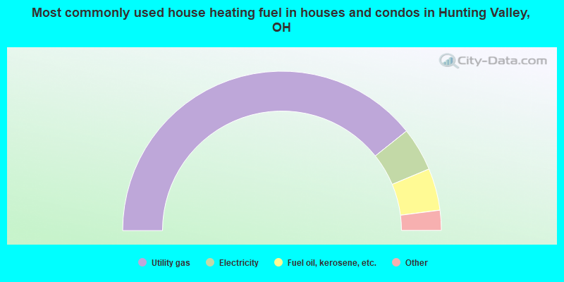
- 79.1%Utility gas
- 8.9%Electricity
- 8.6%Fuel oil, kerosene, etc.
- 3.1%Bottled, tank, or LP gas
- 0.3%No fuel used
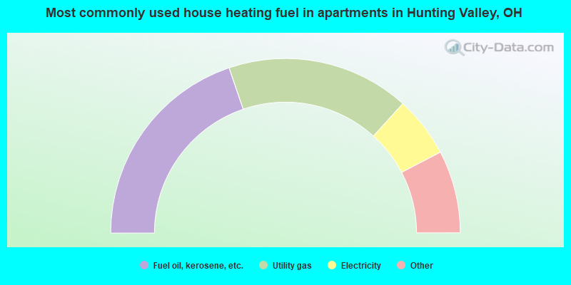
- 46.7%Fuel oil, kerosene, etc.
- 40.0%Utility gas
- 13.3%Electricity
Hunting Valley compared to Ohio state average:
- Median household income significantly above state average.
- Median house value significantly above state average.
- Unemployed percentage significantly below state average.
- Black race population percentage significantly below state average.
- Median age significantly above state average.
- Renting percentage below state average.
- Length of stay since moving in above state average.
- Number of rooms per house significantly above state average.
- Percentage of population with a bachelor's degree or higher significantly above state average.
Hunting Valley on our top lists:
- #17 on the list of "Top 100 cities with highest median household income"
- #21 on the list of "Top 101 cities with the most residents born in Southern Africa (population 500+)"
- #22 on the list of "Top 101 cities with the most residents born in South Africa (population 500+)"
- #42 on the list of "Top 100 best educated cities (highest percentage of bachelor degree holding residents)"
- #51 on the list of "Top 101 cities with the most residents born in Chile (population 500+)"
- #52 on the list of "Top 101 cities with the most people having professional degrees (population 500+)"
- #55 on the list of "Top 101 cities with the most residents born in Australia (population 500+)"
- #63 on the list of "Top 100 cities with biggest houses"
- #91 on the list of "Top 101 cities with the most residents born in Australia and New Zealand Subregion (population 500+)"
- #97 (44022) on the list of "Top 101 zip codes with the largest percentage of Hungarian first ancestries (pop 5,000+)"
- #5 on the list of "Top 101 counties with the most Orthodox congregations"
- #9 on the list of "Top 101 counties with the most Catholic congregations"
- #9 on the list of "Top 101 counties with the most Orthodox adherents"
- #10 on the list of "Top 101 counties with the most Black Protestant congregations"
- #11 on the list of "Top 101 counties with the most Mainline Protestant congregations (pop. 50,000+)"

|
|
Total of 28 patent applications in 2008-2024.