Lyman, Maine

Submit your own pictures of this town and show them to the world
- OSM Map
- Google Map
- MSN Map
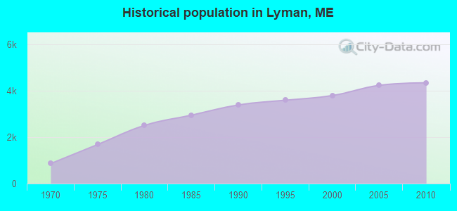
Population change since 2000: +14.5%
 |
| Males: 2,156 | |
| Females: 2,188 |
| Median resident age: | 43.3 years |
| Maine median age: | 43.0 years |
Zip codes: 04002.
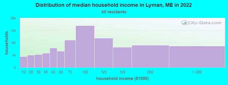
| Lyman: | $89,871 |
| ME: | $69,543 |
Estimated per capita income in 2022: $41,101 (it was $20,203 in 2000)
Lyman town income, earnings, and wages data
Estimated median house or condo value in 2022: $349,120 (it was $109,300 in 2000)
| Lyman: | $349,120 |
| ME: | $290,600 |
Mean prices in 2022: all housing units: $451,552; detached houses: $470,451; townhouses or other attached units: $577,335; in 2-unit structures: $383,179; in 3-to-4-unit structures: $310,696; in 5-or-more-unit structures: $252,113; mobile homes: $105,501
Detailed information about poverty and poor residents in Lyman, ME


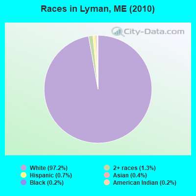
- 4,22497.2%White alone
- 561.3%Two or more races
- 310.7%Hispanic
- 180.4%Asian alone
- 80.2%Black alone
- 70.2%American Indian alone
Races in Lyman detailed stats: ancestries, foreign born residents, place of birth
According to our research of Maine and other state lists, there were 12 registered sex offenders living in Lyman, Maine as of April 27, 2024.
The ratio of all residents to sex offenders in Lyman is 362 to 1.
 Recent articles from our blog. Our writers, many of them Ph.D. graduates or candidates, create easy-to-read articles on a wide variety of topics.
Lyman, ME City Guides:
Ancestries: French (21.6%), English (19.1%), French Canadian (16.9%), Irish (12.4%), United States (10.9%), Italian (6.3%).
Current Local Time: EST time zone
Incorporated on 03/11/1778
Land area: 38.9 square miles.
Population density: 112 people per square mile (very low).
128 residents are foreign born (2.6% North America, 0.4% Europe).
| This town: | 3.4% |
| Maine: | 2.9% |
| Lyman town: | 1.2% ($1,261) |
| Maine: | 1.5% ($1,417) |
Nearest city with pop. 50,000+: Portland, ME  (21.6 miles , pop. 64,249).
Nearest city with pop. 200,000+: Boston, MA (85.0 miles , pop. 589,141).
Nearest city with pop. 1,000,000+: Bronx, NY (247.5 miles , pop. 1,332,650).
Nearest cities:
), ), ), )Latitude: 43.51 N, Longitude: 70.64 W
Area code commonly used in this area: 207
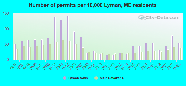
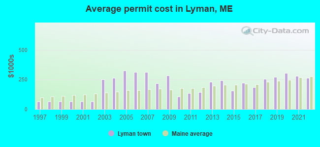
Single-family new house construction building permits:
- 2022: 21 buildings, average cost: $263,000
- 2021: 30 buildings, average cost: $279,600
- 2020: 17 buildings, average cost: $306,200
- 2019: 12 buildings, average cost: $271,600
- 2018: 21 buildings, average cost: $254,700
- 2017: 21 buildings, average cost: $187,000
- 2016: 17 buildings, average cost: $224,000
- 2015: 17 buildings, average cost: $159,400
- 2014: 7 buildings, average cost: $242,600
- 2013: 8 buildings, average cost: $232,800
- 2012: 6 buildings, average cost: $146,400
- 2011: 6 buildings, average cost: $136,400
- 2010: 7 buildings, average cost: $107,100
- 2009: 11 buildings, average cost: $282,700
- 2008: 8 buildings, average cost: $220,200
- 2007: 28 buildings, average cost: $314,300
- 2006: 35 buildings, average cost: $312,000
- 2005: 54 buildings, average cost: $325,000
- 2004: 49 buildings, average cost: $265,300
- 2003: 52 buildings, average cost: $250,000
- 2002: 27 buildings, average cost: $64,500
- 2001: 25 buildings, average cost: $64,500
- 2000: 25 buildings, average cost: $64,500
- 1999: 24 buildings, average cost: $64,500
- 1998: 23 buildings, average cost: $64,500
- 1997: 19 buildings, average cost: $64,800
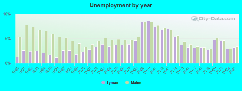
| Here: | 3.2% |
| Maine: | 3.4% |
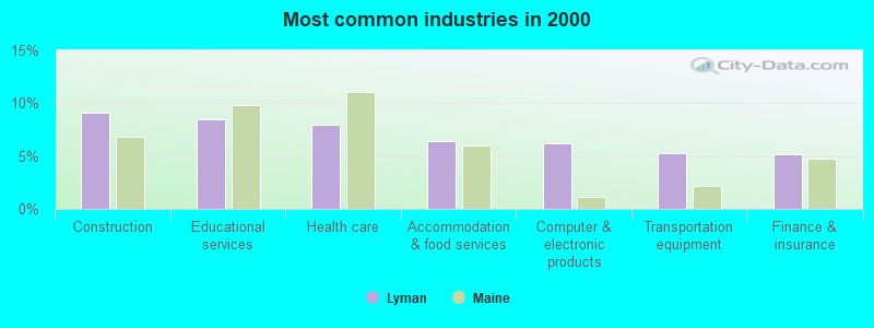
- Construction (9.1%)
- Educational services (8.4%)
- Health care (8.0%)
- Accommodation & food services (6.4%)
- Computer & electronic products (6.2%)
- Transportation equipment (5.3%)
- Finance & insurance (5.2%)
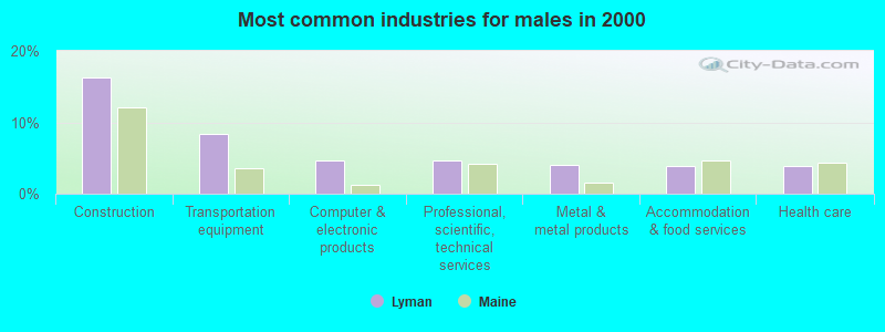
- Construction (16.4%)
- Transportation equipment (8.3%)
- Computer & electronic products (4.6%)
- Professional, scientific, technical services (4.6%)
- Metal & metal products (4.0%)
- Accommodation & food services (3.9%)
- Health care (3.9%)
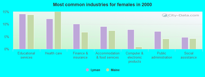
- Educational services (14.1%)
- Health care (12.2%)
- Finance & insurance (10.1%)
- Accommodation & food services (9.1%)
- Computer & electronic products (7.9%)
- Public administration (7.2%)
- Social assistance (4.8%)
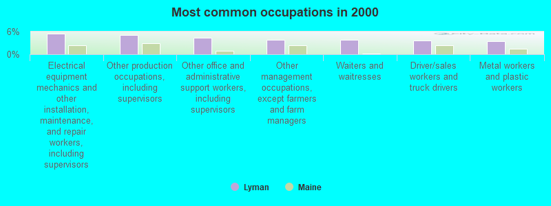
- Electrical equipment mechanics and other installation, maintenance, and repair workers, including supervisors (5.4%)
- Other production occupations, including supervisors (5.1%)
- Other office and administrative support workers, including supervisors (4.4%)
- Other management occupations, except farmers and farm managers (3.9%)
- Waiters and waitresses (3.8%)
- Driver/sales workers and truck drivers (3.7%)
- Metal workers and plastic workers (3.5%)
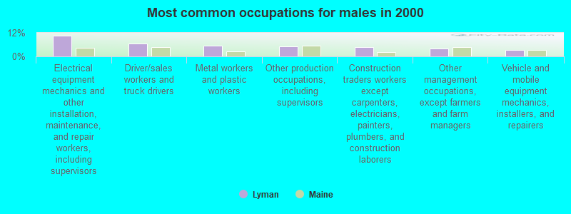
- Electrical equipment mechanics and other installation, maintenance, and repair workers, including supervisors (10.5%)
- Driver/sales workers and truck drivers (6.4%)
- Metal workers and plastic workers (5.3%)
- Other production occupations, including supervisors (5.0%)
- Construction traders workers except carpenters, electricians, painters, plumbers, and construction laborers (4.6%)
- Other management occupations, except farmers and farm managers (4.1%)
- Vehicle and mobile equipment mechanics, installers, and repairers (3.4%)

- Waiters and waitresses (7.1%)
- Information and record clerks, except customer service representatives (6.5%)
- Other office and administrative support workers, including supervisors (6.3%)
- Other production occupations, including supervisors (5.2%)
- Registered nurses (5.0%)
- Secretaries and administrative assistants (4.7%)
- Child care workers (4.3%)
Average climate in Lyman, Maine
Based on data reported by over 4,000 weather stations


(lower is better)
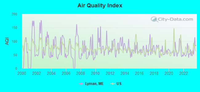
Air Quality Index (AQI) level in 2023 was 70.4. This is about average.
| City: | 70.4 |
| U.S.: | 72.6 |
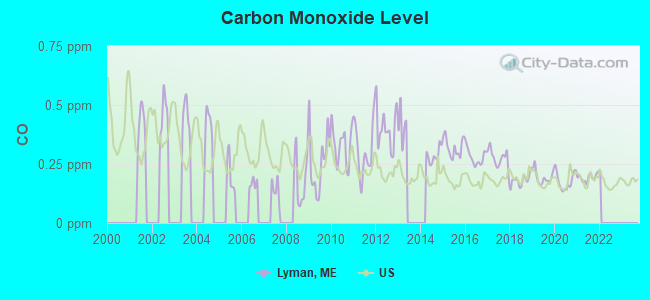
Carbon Monoxide (CO) [ppm] level in 2021 was 0.192. This is better than average. Closest monitor was 21.4 miles away from the city center.
| City: | 0.192 |
| U.S.: | 0.251 |
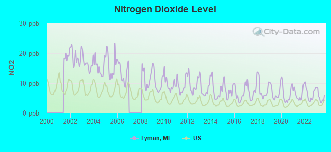
Nitrogen Dioxide (NO2) [ppb] level in 2023 was 5.47. This is about average. Closest monitor was 14.0 miles away from the city center.
| City: | 5.47 |
| U.S.: | 5.11 |
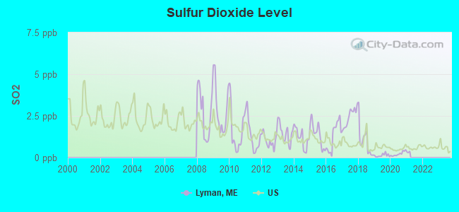
Sulfur Dioxide (SO2) [ppb] level in 2020 was 0.222. This is significantly better than average. Closest monitor was 7.1 miles away from the city center.
| City: | 0.222 |
| U.S.: | 1.515 |
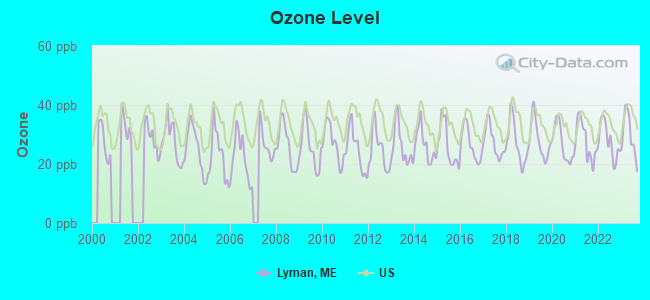
Ozone [ppb] level in 2023 was 29.8. This is about average. Closest monitor was 6.2 miles away from the city center.
| City: | 29.8 |
| U.S.: | 33.3 |
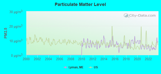
Particulate Matter (PM2.5) [µg/m3] level in 2023 was 6.47. This is better than average. Closest monitor was 9.9 miles away from the city center.
| City: | 6.47 |
| U.S.: | 8.11 |
Tornado activity:
Lyman-area historical tornado activity is significantly above Maine state average. It is 69% smaller than the overall U.S. average.
On 10/10/1966, a category F2 (max. wind speeds 113-157 mph) tornado 8.8 miles away from the Lyman town center caused between $5000 and $50,000 in damages.
On 6/9/1953, a category F3 (max. wind speeds 158-206 mph) tornado 40.6 miles away from the town center injured 5 people and caused between $5000 and $50,000 in damages.
Earthquake activity:
Lyman-area historical earthquake activity is significantly above Maine state average. It is 74% smaller than the overall U.S. average.On 10/16/2012 at 23:12:25, a magnitude 4.7 (4.7 ML, Depth: 10.0 mi, Class: Light, Intensity: IV - V) earthquake occurred 6.4 miles away from the city center
On 4/20/2002 at 10:50:47, a magnitude 5.3 (5.3 ML, Depth: 3.0 mi, Class: Moderate, Intensity: VI - VII) earthquake occurred 167.3 miles away from Lyman center
On 1/19/1982 at 00:14:42, a magnitude 4.7 (4.5 MB, 4.7 MD, 4.5 LG) earthquake occurred 48.2 miles away from the city center
On 10/7/1983 at 10:18:46, a magnitude 5.3 (5.1 MB, 5.3 LG, 5.1 ML) earthquake occurred 187.6 miles away from Lyman center
On 4/20/2002 at 10:50:47, a magnitude 5.2 (5.2 MB, 4.2 MS, 5.2 MW, 5.0 MW) earthquake occurred 167.6 miles away from the city center
On 8/21/1996 at 07:54:14, a magnitude 3.8 (3.8 LG, 3.6 LG, Depth: 6.2 mi, Class: Light, Intensity: II - III) earthquake occurred 58.9 miles away from the city center
Magnitude types: regional Lg-wave magnitude (LG), body-wave magnitude (MB), duration magnitude (MD), local magnitude (ML), surface-wave magnitude (MS), moment magnitude (MW)
Natural disasters:
The number of natural disasters in York County (31) is a lot greater than the US average (15).Major Disasters (Presidential) Declared: 23
Emergencies Declared: 8
Causes of natural disasters: Floods: 21, Storms: 16, Winter Storms: 6, Snows: 5, Winds: 3, Heavy Rains: 2, Hurricanes: 2, Blizzard: 1, Ice Storm: 1, Mudslide: 1, Snowfall: 1, Snowstorm: 1, Tornado: 1, Tropical Storm: 1 (Note: some incidents may be assigned to more than one category).
Hospitals and medical centers near Lyman:
- SOUTHERN MAINE MEDICAL CENTER Acute Care Hospitals (about 8 miles away; BIDDEFORD, ME)
- SANFORD HEALTH CARE FACILITY (Nursing Home, about 9 miles away; SANFORD, ME)
- KINDRED TRANSITIONAL CARE AND REHAB-KENNEBUNK (Nursing Home, about 9 miles away; KENNEBUNK, ME)
- TRULL NURSING HOME (Nursing Home, about 9 miles away; BIDDEFORD, ME)
- SOUTHRIDGE REHAB AND LIVING CTR (Nursing Home, about 9 miles away; BIDDEFORD, ME)
- GREENWOOD CENTER (Nursing Home, about 9 miles away; SANFORD, ME)
- MAINE STAY NURSING HOME (Nursing Home, about 9 miles away; SANFORD, ME)
located in Lyman:
Colleges/universities with over 2000 students nearest to Lyman:
- University of New England (about 14 miles; Biddeford, ME; Full-time enrollment: 4,539)
- University of Southern Maine (about 22 miles; Portland, ME; FT enrollment: 6,647)
- Southern Maine Community College (about 23 miles; South Portland, ME; FT enrollment: 4,666)
- Saint Joseph's College of Maine (about 24 miles; Standish, ME; FT enrollment: 2,010)
- University of New Hampshire-Main Campus (about 30 miles; Durham, NH; FT enrollment: 15,243)
- NHTI-Concord's Community College (about 49 miles; Concord, NH; FT enrollment: 2,865)
- Southern New Hampshire University (about 53 miles; Manchester, NH; FT enrollment: 16,552)
Public elementary/middle school in Lyman:
- LYMAN ELEMENTARY SCHOOL (Location: 39 SCHOOLHOUSE ROAD, Grades: KG-5)
Points of interest:
Notable locations in Lyman: Scotts Cove Camping Area (A), Goodwins Mills Fire and Rescue Department (B). Display/hide their locations on the map
Cemetery: Chadbourne Cemetery (1). Display/hide its location on the map
Lakes and reservoirs: Wadley Pond (A), Bunganut Pond (B), Kennebunk Pond (C), Parker Pond (D), Roberts Pond (E), Round Pond (F), Swan Pond (G), Tarwater Pond (H). Display/hide their locations on the map
Streams, rivers, and creeks: Lords Brook (A), Springy Brook (B), West Outlet (C), Sunken Branch Brook (D), East Outlet (E), Carlisle Brook (F), Bartlett Brook (G). Display/hide their locations on the map
Drinking water stations with addresses in Lyman and their reported violations in the past:
SCOTTS COVE CAMPING AREA (Population served: 125, Groundwater):Past health violations:OAKWOOD HOMEOWNERS ASSOCIATION-2 (Population served: 95, Groundwater):Past monitoring violations:
- MCL, Monthly (TCR) - In AUG-2007, Contaminant: Coliform. Follow-up actions: St Public Notif requested (SEP-06-2007), St Formal NOV issued (SEP-06-2007), St Public Notif received (SEP-24-2007), St Compliance achieved (JUL-31-2009)
- 3 routine major monitoring violations
- 2 regular monitoring violations
Past monitoring violations:BRIARWOOD CHILDRENS HOUSE (Population served: 95, Groundwater):
- One routine major monitoring violation
Past health violations:OAKWOOD HOMEOWNERS ASSOCIATION (Population served: 95, Groundwater):Past monitoring violations:
- MCL, Monthly (TCR) - In AUG-2011, Contaminant: Coliform. Follow-up actions: St Public Notif requested (AUG-16-2011), St Formal NOV issued (AUG-16-2011), St Public Notif received (SEP-19-2011), St Compliance achieved (OCT-05-2012)
- MCL, Monthly (TCR) - In JUL-2011, Contaminant: Coliform. Follow-up actions: St Public Notif requested (JUL-22-2011), St Formal NOV issued (JUL-22-2011), St Public Notif received (AUG-16-2011), St Compliance achieved (OCT-05-2012)
- MCL, Monthly (TCR) - In JUN-2011, Contaminant: Coliform. Follow-up actions: St Public Notif requested (JUL-05-2011), St Formal NOV issued (JUL-05-2011), St Public Notif received (JUL-26-2011), St Compliance achieved (OCT-05-2012)
- MCL, Monthly (TCR) - In OCT-2008, Contaminant: Coliform. Follow-up actions: St Public Notif requested (NOV-25-2008), St Formal NOV issued (NOV-25-2008), St Public Notif received (MAR-03-2009), St Compliance achieved (SEP-07-2011), St Intentional no-action (SEP-09-2011)
- MCL, Monthly (TCR) - In AUG-2008, Contaminant: Coliform. Follow-up actions: St Public Notif requested (SEP-04-2008), St Formal NOV issued (SEP-04-2008), St Public Notif received (OCT-02-2008), St Compliance achieved (SEP-07-2011), St Intentional no-action (SEP-09-2011)
- Follow-up Or Routine LCR Tap M/R - In JUL-01-2012, Contaminant: Lead and Copper Rule. Follow-up actions: St Public Notif requested (AUG-07-2012), St Formal NOV issued (AUG-07-2012), St Compliance achieved (AUG-27-2012), St Public Notif received (SEP-11-2012)
- Water Quality Parameter M/R - Between OCT-2009 and DEC-2009, Contaminant: Lead and Copper Rule. Follow-up actions: St Public Notif requested (MAY-05-2010), St Formal NOV issued (MAY-05-2010), St Compliance achieved (JUL-22-2011), St Intentional no-action (SEP-15-2011)
- Water Quality Parameter M/R - Between JUL-2009 and SEP-2009, Contaminant: Lead and Copper Rule. Follow-up actions: St Public Notif requested (MAY-05-2010), St Formal NOV issued (MAY-05-2010), St Compliance achieved (JUL-22-2011), St Intentional no-action (SEP-15-2011)
- Water Quality Parameter M/R - Between APR-2009 and JUN-2009, Contaminant: Lead and Copper Rule. Follow-up actions: St Public Notif requested (MAY-05-2010), St Formal NOV issued (MAY-05-2010), St Compliance achieved (JUL-22-2011), St Intentional no-action (SEP-15-2011)
- Water Quality Parameter M/R - Between JAN-2009 and MAR-2009, Contaminant: Lead and Copper Rule. Follow-up actions: St Public Notif requested (MAY-05-2010), St Formal NOV issued (MAY-05-2010), St Compliance achieved (JUL-22-2011), St Intentional no-action (SEP-15-2011)
- 2 routine major monitoring violations
Past health violations:ALLAGASH ASHLEYS (Population served: 87, Groundwater):Past monitoring violations:
- OCCT/SOWT Study/Recommendation - In MAR-07-2006, Contaminant: Lead and Copper Rule. Follow-up actions: St Violation/Reminder Notice (MAR-17-2006), St Compliance achieved (MAY-12-2006)
- Public Education - In NOV-18-2005, Contaminant: Lead and Copper Rule. Follow-up actions: St Violation/Reminder Notice (MAR-17-2006), St Compliance achieved (MAR-30-2006)
- Follow-up Or Routine LCR Tap M/R - In JAN-01-2009, Contaminant: Lead and Copper Rule. Follow-up actions: St Public Notif requested (FEB-13-2009), St Formal NOV issued (FEB-13-2009), St Public Notif received (MAR-10-2009), St Compliance achieved (AUG-29-2011)
- Follow-up Or Routine LCR Tap M/R - In JUL-01-2008, Contaminant: Lead and Copper Rule. Follow-up actions: St Public Notif requested (SEP-29-2008), St Formal NOV issued (SEP-29-2008), St Public Notif received (OCT-14-2008), St Compliance achieved (AUG-29-2011)
- Follow-up Or Routine LCR Tap M/R - In JAN-01-2007, Contaminant: Lead and Copper Rule. Follow-up actions: St Public Notif requested (FEB-20-2007), St Violation/Reminder Notice (FEB-20-2007), St Public Notif received (MAR-01-2007), St Compliance achieved (AUG-29-2011)
- Follow-up Or Routine LCR Tap M/R - In JUL-01-2006, Contaminant: Lead and Copper Rule. Follow-up actions: St Public Notif requested (OCT-23-2006), St Violation/Reminder Notice (OCT-23-2006), St Public Notif received (NOV-22-2006), St Compliance achieved (AUG-29-2011)
- Initial, Follow-up, or Routine Source Water M/R - In MAR-17-2006, Contaminant: Lead and Copper Rule. Follow-up actions: St Violation/Reminder Notice (MAR-17-2006)
- 5 routine major monitoring violations
- One minor monitoring violation
- One other older monitoring violation
Past health violations:Past monitoring violations:
- MCL, Monthly (TCR) - In SEP-2011, Contaminant: Coliform. Follow-up actions: St Public Notif requested (OCT-06-2011), St Formal NOV issued (OCT-06-2011), St Public Notif received (DEC-02-2011), St Compliance achieved (FEB-03-2012)
- Monitoring, Repeat Major (TCR) - In AUG-2005, Contaminant: Coliform (TCR). Follow-up actions: St Public Notif requested (SEP-12-2005), St Violation/Reminder Notice (SEP-12-2005), St Compliance achieved (SEP-28-2005), St Intentional no-action (AUG-03-2011)
- 4 routine major monitoring violations
- 2 regular monitoring violations
| This town: | 2.6 people |
| Maine: | 2.3 people |
| This town: | 76.4% |
| Whole state: | 62.9% |
| This town: | 7.8% |
| Whole state: | 9.4% |
Likely homosexual households (counted as self-reported same-sex unmarried-partner households)
- Lesbian couples: 0.2% of all households
- Gay men: 0.7% of all households
| This town: | 4.3% |
| Whole state: | 10.9% |
| This town: | 1.5% |
| Whole state: | 4.1% |
For population 15 years and over in Lyman:
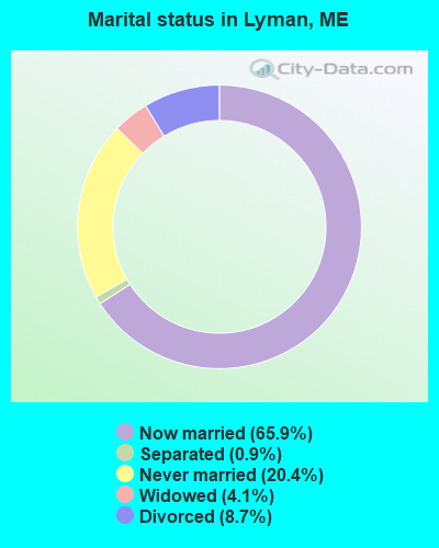
- Never married: 20.4%
- Now married: 65.9%
- Separated: 0.9%
- Widowed: 4.1%
- Divorced: 8.7%
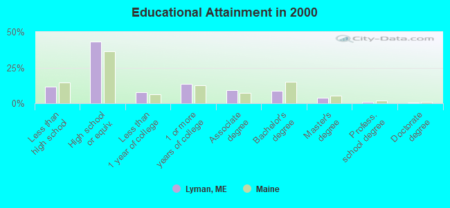
For population 25 years and over in Lyman:
- High school or higher: 88.4%
- Bachelor's degree or higher: 14.0%
- Graduate or professional degree: 5.3%
- Unemployed: 2.4%
- Mean travel time to work (commute): 29.6 minutes
| Here: | 9.6 |
| Maine average: | 11.2 |


Graphs represent county-level data. Detailed 2008 Election Results
Religion statistics for Lyman, ME (based on York County data)
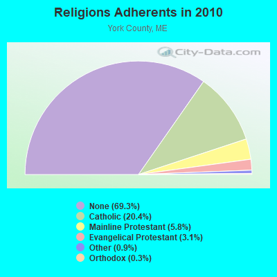

| Religion | Adherents | Congregations |
|---|---|---|
| Catholic | 40,283 | 16 |
| Mainline Protestant | 11,480 | 64 |
| Evangelical Protestant | 6,086 | 51 |
| Other | 1,847 | 18 |
| Orthodox | 625 | 3 |
| Black Protestant | 119 | 1 |
| None | 136,691 | - |
Food Environment Statistics:
| Here: | 2.24 / 10,000 pop. |
| Maine: | 2.80 / 10,000 pop. |
| York County: | 0.05 / 10,000 pop. |
| Maine: | 0.14 / 10,000 pop. |
| This county: | 2.09 / 10,000 pop. |
| State: | 2.20 / 10,000 pop. |
| York County: | 4.23 / 10,000 pop. |
| Maine: | 5.75 / 10,000 pop. |
| This county: | 12.53 / 10,000 pop. |
| State: | 11.02 / 10,000 pop. |
| This county: | 7.7% |
| State: | 8.2% |
| York County: | 24.0% |
| Maine: | 25.0% |
Businesses in Lyman, ME
- Dunkin Donuts: 1
- FedEx: 1
- U-Haul: 1
Strongest AM radio stations in Lyman:
- WMTW (870 AM; 10 kW; GORHAM, ME; Owner: RADIO PARTNERS OF MAINE, L.P.)
- WGIN (930 AM; 10 kW; ROCHESTER, NH; Owner: CAPSTAR TX LIMITED PARTNERSHIP)
- WGAN (560 AM; 5 kW; PORTLAND, ME; Owner: SAGA COMMUNICATIONS OF NEW ENGLAND, LLC)
- WZAN (970 AM; 5 kW; PORTLAND, ME; Owner: SAGA COMMUNICATIONS OF NEW ENGLAND, LLC)
- WPHX (1220 AM; 1 kW; SANFORD, ME; Owner: FNX BROADCASTING L.L.C.)
- WRKO (680 AM; 50 kW; BOSTON, MA; Owner: ENTERCOM BOSTON LICENSE, LLC)
- WIDE (1400 AM; 1 kW; BIDDEFORD, ME; Owner: SACO BAY COMMUNICATIONS GROUP INC)
- WJAE (1440 AM; 5 kW; WESTBROOK, ME; Owner: ALTANTIC COAST RADIO, LLC)
- WLOB (1310 AM; 5 kW; PORTLAND, ME; Owner: ATLANTIC COAST RADIO, LLC)
- WEEI (850 AM; 50 kW; BOSTON, MA; Owner: ENTERCOM BOSTON LICENSE, LLC)
- WBZ (1030 AM; 50 kW; BOSTON, MA; Owner: INFINITY BROADCASTING OPERATIONS, INC.)
- WTSN (1270 AM; 5 kW; DOVER, NH; Owner: GARRISON CITY BROADCASTING, INC.)
- WWZN (1510 AM; 50 kW; BOSTON, MA; Owner: ROSE CITY RADIO CORPORATION)
Strongest FM radio stations in Lyman:
- WPHX-FM (92.1 FM; SANFORD, ME; Owner: FNX BROADCASTING LLC)
- WSEW (88.5 FM; SANFORD, ME; Owner: WORD RADIO EDUCATIONAL FOUNDATION)
- WMEA (90.1 FM; PORTLAND, ME; Owner: MAINE PUBLIC BROADCASTING CORPORATION)
- WCYY (94.3 FM; BIDDEFORD, ME; Owner: CITADEL BROADCASTING COMPANY)
- WSCY (106.9 FM; MOULTONBOROUGH, NH; Owner: NORTHEAST COMMUNICATIONS CORPORATION)
- WRED (95.9 FM; SACO, ME; Owner: ATLANTIC COAST RADIO, LLC)
- WPKQ (103.7 FM; NORTH CONWAY, NH; Owner: CITADEL BROADCASTING COMPANY)
- WBLM (102.9 FM; PORTLAND, ME; Owner: CITADEL BROADCASTING COMPANY)
- WHOM (94.9 FM; MT. WASHINGTON, NH; Owner: CITADEL BROADCASTING COMPANY)
- WUBB (95.3 FM; YORK CENTER, ME; Owner: CAPSTAR TX LIMITED PARTNERSHIP)
- WQEZ (104.7 FM; KENNEBUNKPORT, ME; Owner: MARINER BROADCASTING L.P.)
- WBQQ (99.3 FM; KENNEBUNK, ME; Owner: MARINER BROADCASTING L.P.)
- WJBQ (97.9 FM; PORTLAND, ME; Owner: CITADEL BROADCASTING COMPANY)
- WVFM (105.7 FM; CAMPTON, NH; Owner: DEVON BROADCASTING COMPANY, INC.)
- WPOR (101.9 FM; PORTLAND, ME; Owner: SAGA COMMUNICATIONS OF NEW ENGLAND, LLC)
- WMEX (106.5 FM; FARMINGTON, NH; Owner: WIMMEX, LLC)
- WLKZ (104.9 FM; WOLFEBORO, NH; Owner: TELE-MEDIA COMPANY OF NEW HAMPSHIRE, L.L.C.)
- WBQW (106.3 FM; SCARBOROUGH, ME; Owner: MARINER BROADCASTING LIMITED PARTNER)
- WTHT (107.5 FM; LEWISTON, ME; Owner: RADIO PARTNERS OF MAINE, L.P.)
- WMSJ (89.3 FM; FREEPORT, ME; Owner: DOWNEAST CHRISTIAN COMMUNICATIONS)
TV broadcast stations around Lyman:
- WMEA-TV (Channel 26; BIDDEFORD, ME; Owner: MAINE PUBLIC BROADCASTING CORP.)
- WMTW-TV (Channel 8; POLAND SPRING, ME; Owner: WMTW BROADCAST GROUP, LLC)
- WCSH (Channel 6; PORTLAND, ME; Owner: PACIFIC AND SOUTHERN COMPANY, INC.)
- WGME-TV (Channel 13; PORTLAND, ME; Owner: WGME LICENSEE, LLC)
- WPXT (Channel 51; PORTLAND, ME; Owner: HMW, INC.)
- WPME (Channel 35; LEWISTON, ME; Owner: KB PRIME MEDIA LLC)
- W32CA (Channel 32; PORTLAND, ME; Owner: NATIONAL MINORITY T.V., INC.)
- National Bridge Inventory (NBI) Statistics
- 2Number of bridges
- 7ft / 1.6mTotal length
- 9,671Total average daily traffic
- 483Total average daily truck traffic
- 13,619Total future (year 2036) average daily traffic
FCC Registered Antenna Towers:
31 (See the full list of FCC Registered Antenna Towers in Lyman)FCC Registered Private Land Mobile Towers:
2- Clarkes Wood Rd 7/8 Mi W From Int Of S Waterboro Rd (Lat: 43.521750 Lon: -70.663111), Structure height: 58 m, Call Sign: WNHA469,
Assigned Frequencies: 862.112 MHz, 863.112 MHz, 864.112 MHz, 865.112 MHz, Grant Date: 04/13/2010, Expiration Date: 05/03/2020, Cancellation Date: 09/12/2019, Registrant: Sprint Corporation, 12502 Sunrise Valley Drive, M/S: Varesa-0209, Reston, VA 20196, Phone: (800) 572-8256, Fax: (703) 433-4483, Email:
- Clark Road (Lat: 43.521389 Lon: -70.665833), Type: Tower, Structure height: 48.8 m, Overall height: 54.9 m, Call Sign: WPSU762,
Assigned Frequencies: 854.012 MHz, 854.237 MHz, 855.587 MHz, 857.012 MHz, 857.387 MHz, 858.387 MHz, Grant Date: 08/09/2011, Expiration Date: 08/03/2021, Cancellation Date: 01/09/2014, Certifier: Robin J Glenny, Registrant: Sprint Nextel Corporation, 12502 Sunrise Valley Drive, Reston, VA 20191, Phone: (703) 433-4000, Fax: (703) 433-4483
FCC Registered Broadcast Land Mobile Towers:
4- 481 Goodwins Mills Road (Lat: 43.509528 Lon: -70.582278), Type: Pole, Structure height: 18.9 m, Overall height: 23.4 m, Call Sign: KNFS315, Licensee ID: L00603150,
Assigned Frequencies: 154.250 MHz, 154.310 MHz, Grant Date: 05/10/2022, Expiration Date: 06/30/2032, Registrant: Lyman, Town Of
- Clark Woods Rd 2.75 Ese Of Waterboro (Lat: 43.520639 Lon: -70.664778), Call Sign: WDL64,
Assigned Frequencies: 154.463 MHz, Grant Date: 05/27/2015, Expiration Date: 08/03/2025, Registrant: Utilities Telecom Council, 1129 20th Street Nw, Suite 350, Washington, DC 20036, Phone: (202) 872-0030, Fax: (202) 872-1331, Email:
- Lat: 43.521389 Lon: -70.665278, Call Sign: WQQM943,
Assigned Frequencies: 457.275 MHz, Grant Date: 12/02/2022, Expiration Date: 01/30/2033, Certifier: Paul Beaulieu, Registrant: Utilities Technology Council, 2550 South Clark St., Suite 960, Arlington, VA 22202, Phone: (202) 833-6818, Email:
- MOB, Lat: 43.490222 Lon: -70.630028, Call Sign: WQYI627,
Assigned Frequencies: 451.312 MHz, 452.837 MHz, 456.587 MHz, 457.812 MHz, 462.312 MHz, Grant Date: 10/11/2016, Expiration Date: 10/11/2026, Certifier: Wendy Szymczycha, Registrant: Bearcom Operating LLC, Dallas, TX 75355-9001, Phone: (800) 458-9887, Email:
FCC Registered Microwave Towers:
5- Clark Woods Rd (Lat: 43.521444 Lon: -70.665333), Overall height: 94.5 m, Call Sign: WPJD487,
Assigned Frequencies: 928.418 MHz, 952.418 MHz, 928.831 MHz, 952.831 MHz, Grant Date: 01/31/2001, Expiration Date: 02/22/2011, Cancellation Date: 04/30/2011, Phone: (202) 331-9495
- BROCK ROAD, Us Rte. 202 & Brock Road (Lat: 43.515806 Lon: -70.712389), Type: Pole, Structure height: 57.9 m, Overall height: 60.3 m, Call Sign: WQTB314,
Assigned Frequencies: 19560.0 MHz, Grant Date: 12/23/2013, Expiration Date: 12/23/2023, Cancellation Date: 06/01/2015, Certifier: John E Monday, Registrant: At&t Mobility LLC, 2200 N. Greenville Ave #1w, Richardson, TX 75082, Phone: (972) 234-7003, Fax: (972) 301-6893, Email:
- MESA N LYMAN, 20 Deering Ridge Rd (Lat: 43.573944 Lon: -70.645889), Type: Mtower, Structure height: 59.4 m, Overall height: 60.7 m, Call Sign: WQUG400,
Assigned Frequencies: 10935.0 MHz, Grant Date: 06/30/2014, Expiration Date: 06/30/2024, Certifier: John E Monday, Registrant: At&t Services, Inc., 208 S Akard St, 20f, Dallas, TX 75202, Phone: (855) 699-7073, Fax: (214) 746-6410, Email:
- 387 BROCK ROAD, 387 Brock Road (Lat: 43.515806 Lon: -70.712389), Type: Mtower, Structure height: 57.9 m, Overall height: 60.4 m, Call Sign: WQXK613,
Assigned Frequencies: 19560.0 MHz, Grant Date: 03/31/2016, Expiration Date: 03/31/2026, Certifier: John E Monday, Registrant: At&t Services, Inc., 208 S Akard St, 20f, Dallas, TX 75202, Phone: (855) 699-7073, Fax: (202) 457-3073, Email:
- WATERBORO, Clark Woods Rd (Lat: 43.521389 Lon: -70.665278), Type: Gtower, Structure height: 91 m, Overall height: 91.5 m, Call Sign: KBY73,
Assigned Frequencies: 6605.00 MHz, 6675.00 MHz, 6073.68 MHz, 6605.00 MHz, 6130.51 MHz, Grant Date: 07/11/2018, Expiration Date: 08/05/2028, Registrant: Central Maine Power Company, 57 Old Winthrop Road, Augusta, ME 04330, Phone: (207) 626-9480, Fax: (207) 626-9484, Email:
FCC Registered Paging Towers:
1- Clarkes Wood Road, 7/8 Mi W. Of Intersection Of South Waterb (Lat: 43.521722 Lon: -70.663111), Call Sign: KDS296, Licensee ID: L01422065,
Assigned Frequencies: 454.450 MHz, 454.450 MHz, Grant Date: 05/05/2009, Expiration Date: 04/01/2019, Cancellation Date: 07/13/2010, Certifier: Shawn E Endsley, Registrant: Usa Mobility Wireless, Inc., 3000 Technology Dr. #400, Plano, TX 75074, Phone: (972) 801-0000, Fax: (972) 801-1699, Email:
FCC Registered Amateur Radio Licenses:
26 (See the full list of FCC Registered Amateur Radio Licenses in Lyman)FAA Registered Aircraft Manufacturers and Dealers:
1 (See the full list of FAA Registered Manufacturers and Dealers in Lyman)FAA Registered Aircraft:
7 (See the full list of FAA Registered Aircraft)2003 - 2018 National Fire Incident Reporting System (NFIRS) incidents
- Fire incident types reported to NFIRS in Lyman, ME
- 23148.8%Outside Fires
- 19641.4%Structure Fires
- 398.2%Mobile Property/Vehicle Fires
- 71.5%Other
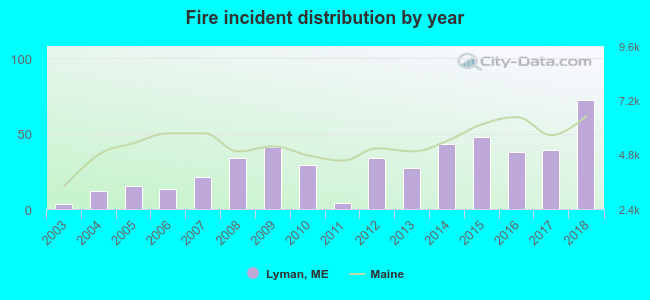 According to the data from the years 2003 - 2018 the average number of fires per year is 30. The highest number of reported fires - 72 took place in 2018, and the least - 3 in 2003. The data has an increasing trend.
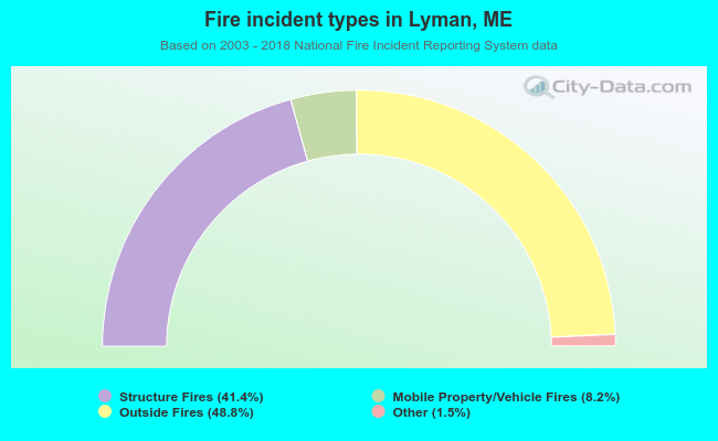 When looking into fire subcategories, the most reports belonged to: Outside Fires (48.8%), and Structure Fires (41.4%).
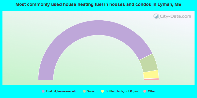
- 85.4%Fuel oil, kerosene, etc.
- 9.2%Wood
- 4.4%Bottled, tank, or LP gas
- 0.5%Electricity
- 0.5%Solar energy
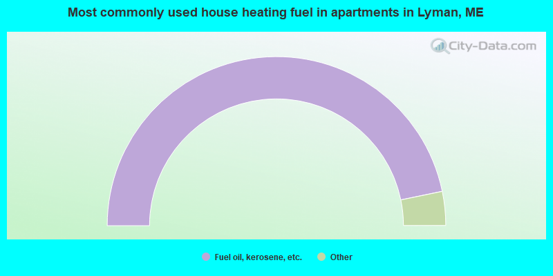
- 93.5%Fuel oil, kerosene, etc.
- 3.3%Bottled, tank, or LP gas
- 3.3%Wood
Lyman compared to Maine state average:
- Unemployed percentage significantly below state average.
- Black race population percentage significantly below state average.
- Hispanic race population percentage below state average.
- Renting percentage significantly below state average.
- Length of stay since moving in significantly above state average.
- Number of rooms per house significantly below state average.
- House age significantly below state average.
- Percentage of population with a bachelor's degree or higher below state average.

|
|
Total of 15 patent applications in 2008-2024.