Manhattan, Kansas
Manhattan: Calvin Hall, KSU Campus
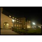
Manhattan: Hale Library, KSU Campus

Manhattan: The Konza Prairie near Manhattan
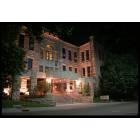
Manhattan: Anderson Hall
Manhattan: Anderson Hall - KANSAS STATE UNIVERSITY
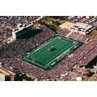
Manhattan: KSU STADIUM - KANSAS STATE UNIVERSITY
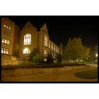
Manhattan: Hale Library, KSU Campus
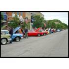
Manhattan: Spring Car Show on Poyntz
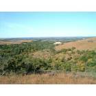
Manhattan: Manhattan, Kansas: Flint Hills
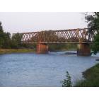
Manhattan: Bridge off hwy 24

Manhattan: Lee sketching the Beach Museum
- see
33
more - add
your
Submit your own pictures of this city and show them to the world
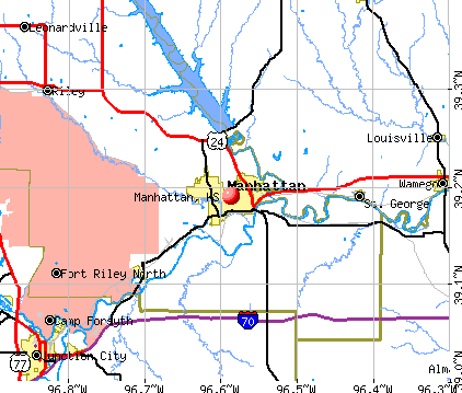
- OSM Map
- General Map
- Google Map
- MSN Map
Population change since 2000: +20.1%
 |
| Males: 27,380 | |
| Females: 26,449 |
| Median resident age: | 25.3 years |
| Kansas median age: | 37.6 years |
Zip codes: 66502, 66503, 66506.
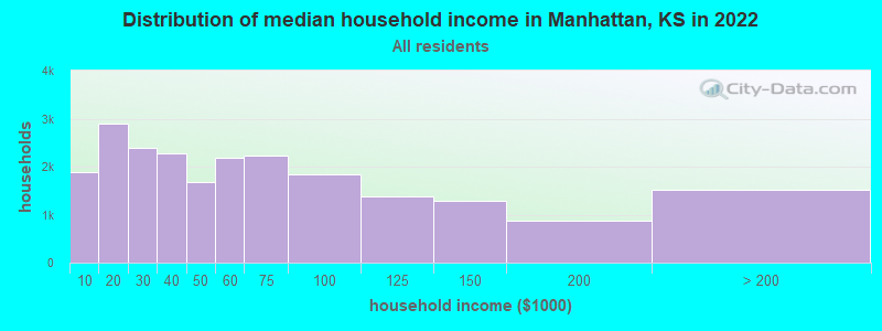
Manhattan Zip Code Map| Manhattan: | $52,091 |
| KS: | $68,925 |
Estimated per capita income in 2022: $34,861 (it was $16,566 in 2000)
Manhattan city income, earnings, and wages data
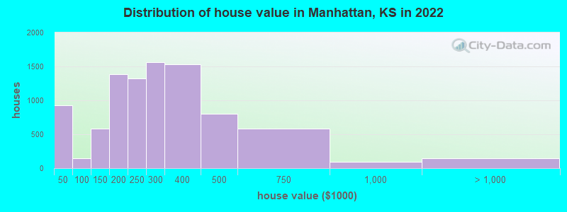
Estimated median house or condo value in 2022: $228,559 (it was $93,700 in 2000)
| Manhattan: | $228,559 |
| KS: | $206,600 |
Mean prices in 2022: all housing units: $308,869; detached houses: $332,040; townhouses or other attached units: $281,862; in 2-unit structures: $102,090; in 3-to-4-unit structures: $109,526; in 5-or-more-unit structures: $46,164; mobile homes: $56,093
Median gross rent in 2022: $919.
(25.3% for White Non-Hispanic residents, 39.7% for Black residents, 29.7% for Hispanic or Latino residents, 24.5% for American Indian residents, 30.7% for other race residents, 27.4% for two or more races residents)
Detailed information about poverty and poor residents in Manhattan, KS


Compare current foreclosures near Manhattan, KS:
| Photo | Address | Area | Beds / Baths | Price | Details |
|---|---|---|---|---|---|

|
#1
Roever Rd
Manhattan, KS 66503
|
1,092 sq. feet
|
1 baths 3 beds |
show details | |

|
#2
Kearney St
Manhattan, KS 66502
|
1,614 sq. feet
|
2 baths 3 beds |
show details | |

|
#3
Strong Ave
Manhattan, KS 66502
|
974 sq. feet
|
1 baths 3 beds |
show details | |

|
#4
Leavenworth St
Manhattan, KS 66502
|
3,239 sq. feet
|
1 baths 4 beds |
show details | |

|
#5
Casement Rd
Manhattan, KS 66502
|
1,652 sq. feet
|
1 baths 2 beds |
show details | |

|
#6
Conrow Dr
Manhattan, KS 66503
|
1,216 sq. feet
|
2 baths 3 beds |
show details | |

|
#7
Foxridge Dr
Manhattan, KS 66502
|
1,588 sq. feet
|
2 baths 3 beds |
show details | |

|
#8
Brookway Dr
Manhattan, KS 66502
|
1,486 sq. feet
|
2 baths 3 beds |
show details | |

|
#9
Shady Valley Dr
Manhattan, KS 66502
|
1,881 sq. feet
|
2 baths 3 beds |
show details | |

|
#10
Northfield Rd
Manhattan, KS 66502
|
1,525 sq. feet
|
2 baths 3 beds |
show details |
| Photo | Address | Area | Beds / Baths | Price | Details |
|---|---|---|---|---|---|

|
#11
Eagles Landing Dr
Manhattan, KS 66502
|
2,252 sq. feet
|
3 baths 6 beds |
show details | |

|
#12
Willowood Cir
Manhattan, KS 66502
|
- sq. feet
|
- baths - beds |
show details | |

|
#13
Stone Dr Apt 1115
Manhattan, KS 66503
|
- sq. feet
|
- baths - beds |
show details | |

|
#14
Tuttle Creek Blvd Lot 112
Manhattan, KS 66502
|
- sq. feet
|
- baths - beds |
show details | |

|
#15
Tuttle Creek Blvd Lot 88
Manhattan, KS 66502
|
- sq. feet
|
- baths - beds |
show details | |

|
#16
N 4th St Apt 112
Manhattan, KS 66502
|
- sq. feet
|
- baths - beds |
show details | |

|
#17
Tuttle Creek Blvd Lot 550
Manhattan, KS 66502
|
- sq. feet
|
- baths - beds |
show details | |

|
#18
Farm Bureau Rd Lot 119
Manhattan, KS 66502
|
- sq. feet
|
- baths - beds |
show details | |

|
#19
Pebblebrook Cir # 8
Manhattan, KS 66503
|
- sq. feet
|
- baths - beds |
show details | |

|
#20
Bertrand St Apt D
Manhattan, KS 66502
|
- sq. feet
|
- baths - beds |
show details |
| Photo | Address | Area | Beds / Baths | Price | Details |
|---|---|---|---|---|---|

|
#21
Rio Hondo Way, Apt 301
Manhattan, KS 66502
|
- sq. feet
|
- baths - beds |
show details | |

|
#22
Allen Rd
Manhattan, KS 66502
|
- sq. feet
|
- baths - beds |
show details | |

|
#23
Pebblebrook Cir Apt 6
Manhattan, KS 66503
|
- sq. feet
|
- baths - beds |
show details | |

|
#24
Walters Dr Apt 104
Manhattan, KS 66502
|
- sq. feet
|
- baths - beds |
show details | |

|
#25
Tuttle Creek Blvd Lot 323
Manhattan, KS 66502
|
- sq. feet
|
- baths - beds |
show details | |

|
#26
Stagg Hill Rd
Manhattan, KS 66502
|
- sq. feet
|
- baths - beds |
show details | |

|
#27
W 61st Ave
Manhattan, KS 66502
|
- sq. feet
|
- baths - beds |
show details | |

|
#28
Highway K18
Manhattan, KS 66502
|
- sq. feet
|
- baths - beds |
show details | |

|
#29
14th St
Ogden, KS 66517
|
- sq. feet
|
- baths - beds |
$39,900
|
show details |

|
#30
Lilac Ln
Wamego, KS 66547
|
864 sq. feet
|
1 baths 2 beds |
show details |
| Photo | Address | Area | Beds / Baths | Price | Details |
|---|---|---|---|---|---|

|
#31
Smith Rd
Junction City, KS 66441
|
532 sq. feet
|
2 baths 3 beds |
show details | |

|
#32
Fuller Cir
Junction City, KS 66441
|
1,884 sq. feet
|
2 baths 4 beds |
show details | |

|
#33
Spencer St
Wamego, KS 66547
|
1,326 sq. feet
|
2 baths 4 beds |
show details | |

|
#34
N Noble St
Riley, KS 66531
|
1,176 sq. feet
|
2 baths 2 beds |
show details | |

|
#35
Vine St
Wamego, KS 66547
|
1,392 sq. feet
|
1 baths 3 beds |
show details | |

|
#36
N Walnut St
Westmoreland, KS 66549
|
2,052 sq. feet
|
3 baths 3 beds |
show details | |

|
#37
Blackjack Rd
Saint George, KS 66535
|
1,200 sq. feet
|
1 baths 2 beds |
show details | |

|
#38
Bluebird Rd
Wamego, KS 66547
|
1,937 sq. feet
|
3 baths 3 beds |
show details | |

|
#39
Cedar Meadows Rd
Wamego, KS 66547
|
- sq. feet
|
- baths - beds |
show details | |

|
#40
Palomino Ln
Ogden, KS 66517
|
- sq. feet
|
- baths - beds |
show details |
| Photo | Address | Area | Beds / Baths | Price | Details |
|---|---|---|---|---|---|

|
#41
Dry Creek Rd
Olsburg, KS 66520
|
- sq. feet
|
- baths - beds |
show details | |

|
#42
W 17th St Apt 4
Junction City, KS 66441
|
- sq. feet
|
- baths - beds |
show details | |

|
#43
Legion Dr
Saint George, KS 66535
|
- sq. feet
|
- baths - beds |
show details | |

|
#44
Mariposa Dr
Fort Riley, KS 66442
|
- sq. feet
|
- baths - beds |
show details | |

|
#45
Carriage St Apt 1
Fort Riley, KS 66442
|
- sq. feet
|
- baths - beds |
show details | |

|
#46
Flush Rd
Saint George, KS 66535
|
- sq. feet
|
- baths - beds |
show details | |

|
#47
Center St
Wamego, KS 66547
|
- sq. feet
|
- baths - beds |
show details | |

|
#48
7th St, Apt B
Ogden, KS 66517
|
- sq. feet
|
- baths - beds |
show details | |

|
#49
Ash St Lot 3
Wamego, KS 66547
|
- sq. feet
|
- baths - beds |
show details | |

|
Check over 1 million property listings on Foreclosure.com!
|
browse all offers | |||


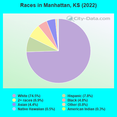
- 39,87074.5%White alone
- 4,1947.8%Hispanic
- 3,6976.9%Two or more races
- 2,5964.8%Black alone
- 2,3824.4%Asian alone
- 4500.8%Other race alone
- 2800.5%Native Hawaiian and Other
Pacific Islander alone - 1660.3%American Indian alone
Races in Manhattan detailed stats: ancestries, foreign born residents, place of birth
According to our research of Kansas and other state lists, there were 76 registered sex offenders living in Manhattan, Kansas as of April 27, 2024.
The ratio of all residents to sex offenders in Manhattan is 738 to 1.
The ratio of registered sex offenders to all residents in this city is much lower than the state average.
 Recent articles from our blog. Our writers, many of them Ph.D. graduates or candidates, create easy-to-read articles on a wide variety of topics.


Latest news from Manhattan, KS collected exclusively by city-data.com from local newspapers, TV, and radio stations
Ancestries: German (19.5%), American (15.1%), English (5.9%), Irish (5.0%), European (4.4%), Italian (2.9%).
Current Local Time: CST time zone
Incorporated in 1857
Elevation: 1020 feet
Land area: 15.0 square miles.
Population density: 3,583 people per square mile (average).
4,291 residents are foreign born (4.2% Asia, 2.2% Latin America).
| This city: | 8.0% |
| Kansas: | 7.1% |
Median real estate property taxes paid for housing units with mortgages in 2022: $3,670 (1.4%)
Median real estate property taxes paid for housing units with no mortgage in 2022: $3,045 (1.7%)
Nearest city with pop. 50,000+: Topeka, KS  (49.3 miles , pop. 122,377).
Nearest city with pop. 200,000+: Kansas City, MO (109.3 miles , pop. 441,545).
Nearest city with pop. 1,000,000+: Dallas, TX (442.2 miles , pop. 1,188,580).
Nearest cities:
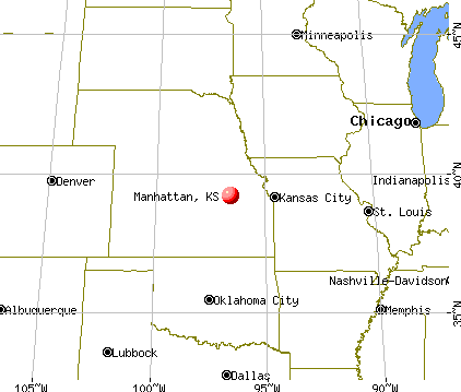
), ), )Latitude: 39.19 N, Longitude: 96.59 W
Daytime population change due to commuting: +6,431 (+12.0%)
Workers who live and work in this city: 23,495 (80.9%)
Area code: 785

Manhattan, Kansas accommodation & food services, waste management - Economy and Business Data
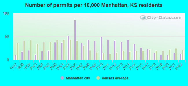
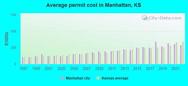
Single-family new house construction building permits:
- 2022: 57 buildings, average cost: $293,400
- 2021: 66 buildings, average cost: $308,300
- 2020: 43 buildings, average cost: $320,800
- 2019: 48 buildings, average cost: $269,700
- 2018: 64 buildings, average cost: $345,300
- 2017: 103 buildings, average cost: $255,900
- 2016: 120 buildings, average cost: $264,100
- 2015: 151 buildings, average cost: $252,800
- 2014: 193 buildings, average cost: $215,700
- 2013: 173 buildings, average cost: $229,800
- 2012: 186 buildings, average cost: $208,200
- 2011: 197 buildings, average cost: $197,400
- 2010: 220 buildings, average cost: $195,600
- 2009: 179 buildings, average cost: $199,300
- 2008: 193 buildings, average cost: $184,900
- 2007: 160 buildings, average cost: $164,800
- 2006: 381 buildings, average cost: $151,800
- 2005: 231 buildings, average cost: $156,500
- 2004: 165 buildings, average cost: $127,000
- 2003: 168 buildings, average cost: $122,300
- 2002: 88 buildings, average cost: $132,300
- 2001: 82 buildings, average cost: $124,000
- 2000: 51 buildings, average cost: $155,500
- 1999: 92 buildings, average cost: $122,000
- 1998: 81 buildings, average cost: $108,100
- 1997: 45 buildings, average cost: $109,000
| Here: | 1.6% |
| Kansas: | 2.0% |
Population change in the 1990s: +1,692 (+3.9%).
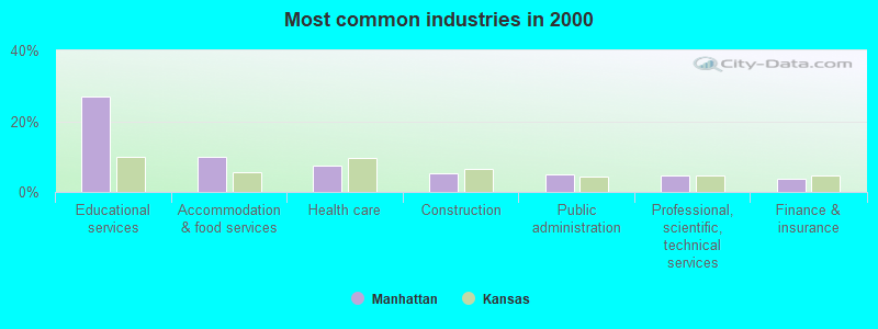
- Educational services (27.1%)
- Accommodation & food services (9.8%)
- Health care (7.6%)
- Construction (5.2%)
- Public administration (4.8%)
- Professional, scientific, technical services (4.6%)
- Finance & insurance (3.9%)

- Educational services (24.1%)
- Construction (9.4%)
- Accommodation & food services (9.4%)
- Public administration (5.6%)
- Professional, scientific, technical services (4.9%)
- Administrative & support & waste management services (3.9%)
- Health care (3.8%)
- Educational services (30.3%)
- Health care (11.6%)
- Accommodation & food services (10.3%)
- Finance & insurance (5.0%)
- Professional, scientific, technical services (4.2%)
- Public administration (4.0%)
- Social assistance (3.7%)
- Postsecondary teachers (7.6%)
- Other office and administrative support workers, including supervisors (5.2%)
- Retail sales workers, except cashiers (4.8%)
- Other management occupations, except farmers and farm managers (4.6%)
- Cooks and food preparation workers (3.3%)
- Building and grounds cleaning and maintenance occupations (3.3%)
- Waiters and waitresses (2.9%)
- Postsecondary teachers (9.2%)
- Cooks and food preparation workers (5.0%)
- Other management occupations, except farmers and farm managers (5.0%)
- Retail sales workers, except cashiers (4.7%)
- Building and grounds cleaning and maintenance occupations (3.9%)
- Computer specialists (3.9%)
- Electrical equipment mechanics and other installation, maintenance, and repair workers, including supervisors (3.8%)
- Other office and administrative support workers, including supervisors (7.8%)
- Postsecondary teachers (5.9%)
- Secretaries and administrative assistants (5.2%)
- Waiters and waitresses (4.8%)
- Retail sales workers, except cashiers (4.8%)
- Information and record clerks, except customer service representatives (4.6%)
- Other management occupations, except farmers and farm managers (4.2%)
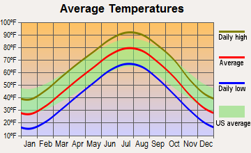
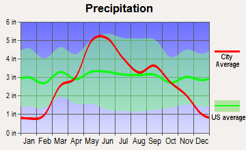
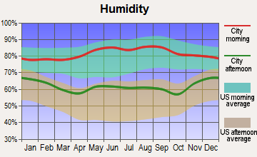
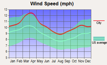
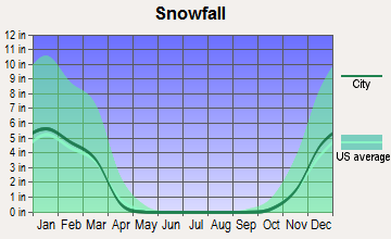
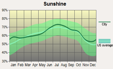
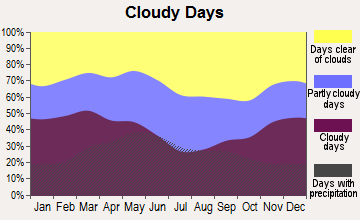
Average climate in Manhattan, Kansas
Based on data reported by over 4,000 weather stations
|
|


Tornado activity:
Manhattan-area historical tornado activity is near Kansas state average. It is 83% greater than the overall U.S. average.
On 6/11/2008, a category F4 (max. wind speeds 207-260 mph) tornado 7.8 miles away from the Manhattan city center caused $66 million in damages.
On 5/19/1960, a category F4 tornado 14.0 miles away from the city center injured 12 people and caused between $5,000,000 and $50,000,000 in damages.
Earthquake activity:
Manhattan-area historical earthquake activity is significantly above Kansas state average. It is 584% greater than the overall U.S. average.On 9/3/2016 at 12:02:44, a magnitude 5.8 (5.8 MW, Depth: 3.5 mi, Class: Moderate, Intensity: VI - VII) earthquake occurred 192.2 miles away from Manhattan center
On 11/6/2011 at 03:53:10, a magnitude 5.7 (5.7 MW, Depth: 3.2 mi) earthquake occurred 253.2 miles away from Manhattan center
On 11/12/2014 at 21:40:00, a magnitude 4.9 (4.9 MW, Depth: 2.5 mi, Class: Light, Intensity: IV - V) earthquake occurred 144.1 miles away from the city center
On 2/13/2016 at 17:07:06, a magnitude 5.1 (5.1 MW, Depth: 5.2 mi) earthquake occurred 219.8 miles away from the city center
On 1/19/2020 at 19:08:42, a magnitude 4.5 (4.5 MW, Depth: 3.1 mi) earthquake occurred 110.1 miles away from the city center
On 11/7/2016 at 01:44:24, a magnitude 5.0 (5.0 MW, Depth: 2.8 mi) earthquake occurred 221.6 miles away from Manhattan center
Magnitude types: moment magnitude (MW)
Natural disasters:
The number of natural disasters in Riley County (13) is near the US average (15).Major Disasters (Presidential) Declared: 8
Emergencies Declared: 2
Causes of natural disasters: Storms: 8, Floods: 7, Tornadoes: 6, Winds: 3, Winter Storms: 3, Hurricane: 1, Landslide: 1, Mudslide: 1, Snowstorm: 1, Other: 1 (Note: some incidents may be assigned to more than one category).
Main business address for: LANDMARK BANCORP INC (NATIONAL COMMERCIAL BANKS).
Hospitals and medical centers in Manhattan:
- MANHATTAN SURGICAL HOSPITAL LLC (Physician, provides emergency services, 1829 COLLEGE AVENUE)
- MEMORIAL HOSPITAL (1105 SUNSET AVE)
- MERCY REGIONAL HEALTH CENTER (Voluntary non-profit - Church, 1823 COLLEGE AVE)
- MEADOWLARK HILLS (2121 MEADOWLARK RD)
- STONEYBROOK RETIREMENT COMMUNITY (2025 LITTLE KITTEN AVE)
- VIA CHRISTI VILLAGE MANHATTAN INC (2800 WILLOW GROVE RD)
- WHARTON MANOR (2101 CLAFLIN RD)
- FLINT HILLS DIALYSIS LLC (1133 COLLEGE AVE.)
- HOMECARE AND HOSPICE INC (3801 VANESTA DRIVE)
- MEADOWLARK HOME HEALTH (2121 MEADOWLARK RD)
Airports and heliports located in Manhattan:
- Manhattan Regional Airport (MHK) (Runways: 2, Commercial Ops: 3,480, Itinerant Ops: 9,915, Local Ops: 8,750, Military Ops: 1,638)
- N & N Airport (49KS) (Runways: 1)
- Smith Airport (43KS) (Runways: 1)
- Sunshine Ranch Airport (SN92) (Runways: 1)
- Tracy Airport (5KS6) (Runways: 1)
- Mercy Regional Health Center Heliport (3KS6)
Colleges/Universities in Manhattan:
- Kansas State University (Full-time enrollment: 20,703; Location: Anderson Hall; Public; Website: www.k-state.edu; Offers Doctor's degree)
- Manhattan Area Technical College (Full-time enrollment: 629; Location: 3136 Dickens Ave; Public; Website: www.manhattantech.edu)
- Marinello Schools of Beauty-Manhattan (Full-time enrollment: 292; Location: 512 Poyntz Ave; Private, for-profit; Website: www.marinello.com)
- Manhattan Christian College (Full-time enrollment: 279; Location: 1415 Anderson Ave; Private, not-for-profit; Website: www.mccks.edu)
- Bellus Academy (Full-time enrollment: 258; Location: 1130 Westloop Place; Private, for-profit; Website: www.bellusacademy.edu)
Other colleges/universities with over 2000 students near Manhattan:
- Washburn University (about 49 miles; Topeka, KS; Full-time enrollment: 5,092)
- Emporia State University (about 59 miles; Emporia, KS; FT enrollment: 4,687)
- University of Kansas (about 74 miles; Lawrence, KS; FT enrollment: 22,788)
- Baker University (about 81 miles; Baldwin City, KS; FT enrollment: 2,752)
- Highland Community College (about 85 miles; Highland, KS; FT enrollment: 2,148)
- Butler Community College (about 98 miles; El Dorado, KS; FT enrollment: 6,676)
- Kansas City Kansas Community College (about 99 miles; Kansas City, KS; FT enrollment: 4,718)
Public high school in Manhattan:
- MANHATTAN HIGH SCHOOL WEST/EAST CAMPUS (Students: 1,916, Location: 2100 POYNTZ AVENUE, Grades: 9-12)
Private high school in Manhattan:
Biggest public elementary/middle schools in Manhattan:
- FRANK V BERGMAN ELEM (Students: 449, Location: 3430 LOMBARD, Grades: PK-6)
- NORTHVIEW ELEM (Students: 440, Location: 300 GRIFFITH DR, Grades: PK-6)
- AMANDA ARNOLD ELEM (Students: 418, Location: 1435 HUDSON, Grades: PK-6)
- MARLATT ELEM (Students: 405, Location: 2715 HOBBS, Grades: PK-6)
- SUSAN B ANTHONY MIDDLE SCHOOL (Students: 379, Location: 2501 BROWNING, Grades: PK-8)
- DWIGHT D EISENHOWER MIDDLE SCHOOL (Students: 365, Location: 800 WALTERS DR, Grades: 7-8)
- WOODROW WILSON ELEM (Students: 341, Location: 312 N JULIETTE AVENUE, Grades: PK-6)
- THEO ROOSEVELT ELEM (Students: 310, Location: 1401 HOUSTON STREET, Grades: PK-6)
- LEE ELEM (Students: 258, Location: 701 LEE STREET, Grades: PK-6)
- BLUEMONT ELEMENTARY SCHOOL (Location: 714 BLUEMONT AVE., Grades: PK-6)
Private elementary/middle school in Manhattan:
Points of interest:
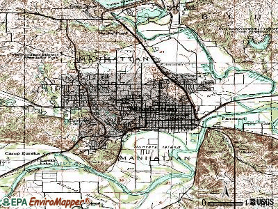
Notable locations in Manhattan: Manhattan Country Club (A), Colbert Hills Golf Course (B), Kansas State University Manhattan Campus Visitor Center Garden (C), Kansas State University Manhattan Campus Conservatory Garden (D), Sunset Zoo (E), Larry Norvell Band Shell (F), City Splash Park (G), Rebekah IOOF Home (H), Stagg Hill Golf Course (I), Kansas State University Manhattan Campus Bramlage Coliseum (J), Kansas State University Manhattan Campus Bill Snyder Family Stadium (K), Kansas State University Manhattan Campus President's Residence (L), Kansas State University Manhattan Campus Power Plant (M), Kansas State University Triga Mark II Reactor Facility (N), Riley County Fairgrounds (O), Village Plaza (P), First United Methodist Church - Harris Activity Center (Q), First United Methodist Church - Alan Lee Center (R), Kansas State University Manhattan Campus Beach Art Museum (S), Kansas State University Manhattan Campus Hale Library (T). Display/hide their locations on the map
Shopping Centers: Manhattan Town Center Shopping Center (1), West Loop Shopping Center (2), Boulevard Bend Shopping Center (3), Aggieville Shopping Center (4). Display/hide their locations on the map
Main business address in Manhattan: LANDMARK BANCORP INC (A). Display/hide its location on the map
Churches in Manhattan include: Kansas State University Manhattan Campus All Faiths Chapel (A), Kansas State University Manhattan Campus Danforth Chapel (B), Kingdom Hall of Jehovah's Witnesses (C), Seven Dolors Catholic Church (D), Bethel African Methodist Episcopal Church (E), Pilgrim Baptist Church (F), Blue Valley Memorial United Methodist Church (G), Community of Christ (H), College Avenue United Methodist Church (I). Display/hide their locations on the map
Cemetery: Sunset Cemetery (1). Display/hide its location on the map
Lake: Sand Lake (A). Display/hide its location on the map
Parks in Manhattan include: CiCo Park (1), Frank Anneberg Park (2), Goodnow Park (3), Longs Park (4), Northview Park (5), Pioneer Park (6), Warner Memorial Park (7), Westwood Park (8), Memorial Stadium (9). Display/hide their locations on the map
Tourist attractions: Beach Museum of Art (701 Beach Lane) (1), Kansas State University - Libraries (Cultural Attractions- Events- & Facilities; 2610 Claflin Road) (2), Riley County Historical Museum (Cultural Attractions- Events- & Facilities; 2309 Claflin Road) (3), Zoo Sunset (Recreation Areas; 2333 Oak Drive) (4), Aladdin's Castle (Amusement & Theme Parks; 100 Manhattan Town Centre) (5), Bird Music & Amusement Inc (Amusement & Theme Parks; 2505 Stagg Hill Road) (6), Chamber of Commerce (501 Poyntz Avenue) (7), Wonder Workshop Children's Museum (1006 Leavenworth Street) (8), Wolf House Museum (630 Fremont Street) (9). Display/hide their approximate locations on the map
Hotels: Noble Hospitality (1641 Anderson Avenue) (1), Days Inn (1501 Tuttle Creek Blvd) (2), Regency Inn (419 Holiday Drive) (3), Westchester Park Apartments (2100 Westchester Drive) (4), Hampton Inn Manhattan (501 East Poyntz) (5), Comfort Inn Manhattan (150 East Poyntz Avenue) (6), Motel 6 (510 Tuttle Creek Boulevard) (7), Burgundy's Restaurant Club (530 Richards Drive) (8), Ramada Plaza Hotel (N 17th St AT Anderson Ave) (9). Display/hide their approximate locations on the map
Courts: Riley-County - District Court- District Court Clerk (100 Courthouse Plaza) (1), Riley-County - District Court- Juvenile Intake & Attendant Care (115 North 4th Street) (2), Riley-County - District Court- Jury Clerk (100 Courthouse Plaza) (3), Riley-County - District Court- District Judges- Division Iii- (100 Courthouse Plaza) (4), Riley-County - District Court- District Judges- Division Ii- (100 Courthouse Plaza) (5), Riley-County - District Court- District Judges- Division I- (100 Courthouse Plaza) (6), Riley-County - District Court- District Court Clerk- Domestic Division (110 Courthouse Plaza) (7), Manhattan City - City Prosecutor Traffic- Legal Department- Municipal C (610 Colorado Street) (8), Riley-County - District Court- Court Services-Probation (100 Courthouse Plaza) (9). Display/hide their approximate locations on the map
Birthplace of: Del Close - Actor, Earl Woods - Army Colonel, Bob Anderson (runner) - Photographer, Bobby Douglass - Football player, Damon Runyon - (1884-1947), author, Elvira - horror actress, Jeremy Bates (American football) - Football coach, Jon McGraw - 2005 NFL player (Detroit Lions, born: Apr 2, 1979), Jordy Nelson - College football player, Philip Fox (astronomer) - Astronomer and Army officer.
Drinking water stations with addresses in Manhattan and their reported violations in the past:
KONZA VALLEY WATER BENEFIT DISTRICT (Population served: 345, Purch groundwater):Past health violations:BLUE RIVER HILLS IMPVMT DISTRICT (Population served: 89, Groundwater under infl of surface water):
- MCL, Average - Between JAN-2008 and MAR-2008, Contaminant: Tetrachloroethylene. Follow-up actions: St Public Notif requested (MAR-06-2008), St Violation/Reminder Notice (MAR-06-2008), St Public Notif received (MAR-25-2008), St Compliance achieved (SEP-30-2008)
- MCL, Average - Between OCT-2007 and DEC-2007, Contaminant: Tetrachloroethylene. Follow-up actions: St Public Notif requested (DEC-03-2007), St Violation/Reminder Notice (DEC-03-2007), St Public Notif received (DEC-07-2007), St Compliance achieved (SEP-30-2008)
- MCL, Average - Between JUL-2007 and SEP-2007, Contaminant: Tetrachloroethylene. Follow-up actions: St Public Notif requested (AUG-25-2007), St Violation/Reminder Notice (AUG-25-2007), St Public Notif received (AUG-30-2007), St Compliance achieved (SEP-30-2008)
Past health violations:TUTTLE CREEK RESERVOIR COE STOCKDALE PRK (Population served: 25, Groundwater):Past monitoring violations:
- MCL, Monthly (TCR) - In MAY-2014, Contaminant: Coliform. Follow-up actions: St Public Notif requested (JUN-03-2014), St Violation/Reminder Notice (JUN-03-2014), St Compliance achieved (JUN-30-2014)
- MCL, Monthly (TCR) - In JUN-2008, Contaminant: Coliform. Follow-up actions: St Violation/Reminder Notice (JUL-07-2008), St Compliance achieved (JUL-31-2008), St Violation/Reminder Notice (FEB-05-2010), St Public Notif received (APR-15-2010)
- Monitoring of Treatment (SWTR-Filter) - In JUL-2012. Follow-up actions: St Compliance achieved (AUG-21-2012), St Public Notif requested (AUG-24-2012), St Violation/Reminder Notice (AUG-24-2012), St Public Notif received (MAR-04-2013)
- Monitoring of Treatment (SWTR-Filter) - In JUL-2012. Follow-up actions: St Compliance achieved (AUG-21-2012), St Public Notif requested (AUG-24-2012), St Violation/Reminder Notice (AUG-24-2012), St Public Notif received (MAR-04-2013)
- Monitoring of Treatment (SWTR-Filter) - In FEB-2012. Follow-up actions: St Compliance achieved (APR-05-2012), St Public Notif requested (APR-12-2012), St Violation/Reminder Notice (APR-12-2012)
- Monitoring of Treatment (SWTR-Filter) - In FEB-2012. Follow-up actions: St Compliance achieved (APR-05-2012), St Public Notif requested (APR-12-2012), St Violation/Reminder Notice (APR-12-2012)
- 7 minor monitoring violations
Past monitoring violations:
- 3 minor monitoring violations
Drinking water stations with addresses in Manhattan that have no violations reported:
- MANHATTAN, CITY OF (Population served: 56,069, Primary Water Source Type: Groundwater)
- HUNTERS ISLAND WATER DISTRICT (Population served: 600, Primary Water Source Type: Purch groundwater)
- STAGG HILL GOLF CLUB, INC (Population served: 50, Primary Water Source Type: Groundwater)
| This city: | 2.3 people |
| Kansas: | 2.5 people |
| This city: | 47.3% |
| Whole state: | 66.0% |
| This city: | 5.7% |
| Whole state: | 5.8% |
Likely homosexual households (counted as self-reported same-sex unmarried-partner households)
- Lesbian couples: 0.4% of all households
- Gay men: 0.2% of all households
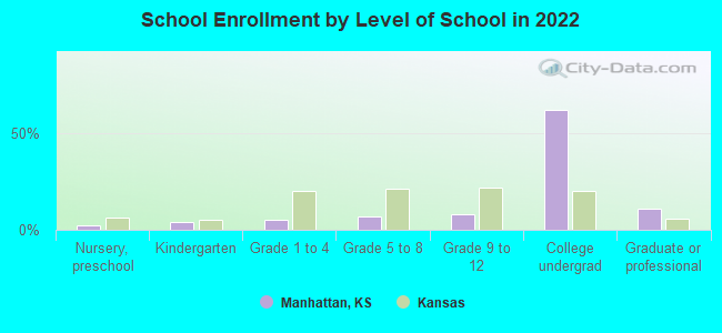
People in group quarters in Manhattan in 2010:
- 5,439 people in college/university student housing
- 306 people in nursing facilities/skilled-nursing facilities
- 255 people in workers' group living quarters and job corps centers
- 95 people in local jails and other municipal confinement facilities
- 56 people in group homes intended for adults
- 49 people in other noninstitutional facilities
- 27 people in emergency and transitional shelters (with sleeping facilities) for people experiencing homelessness
People in group quarters in Manhattan in 2000:
- 5,091 people in college dormitories (includes college quarters off campus)
- 294 people in nursing homes
- 125 people in military transient quarters for temporary residents
- 90 people in military barracks, etc.
- 78 people in homes for the mentally retarded
- 44 people in mental (psychiatric) hospitals or wards
- 32 people in other noninstitutional group quarters
- 31 people in local jails and other confinement facilities (including police lockups)
- 8 people in homes for the mentally ill
Banks with most branches in Manhattan (2011 data):
- Kansas State Bank of Manhattan: Poyntz Avenue Branch, Highway 24 Branch, Kansas State Bank Of Manhattan, Drive-In Facility. Info updated 2006/11/03: Bank assets: $798.5 mil, Deposits: $672.2 mil, local headquarters, positive income, Commercial Lending Specialization, 6 total offices, Holding Company: Manhattan Banking Corporation
- Commerce Bank: K-State Student Union Branch, Manhattan Main Branch, Manhattan Westport Commons Branch. Info updated 2011/07/07: Bank assets: $20,493.6 mil, Deposits: $16,805.3 mil, headquarters in Kansas City, MO, positive income, 206 total offices, Holding Company: Commerce Bancshares, Inc.
- UMB National Bank of America: Manhattan Branch at 529 Humboldt Street, branch established on 1905/01/01; Anderson Avenue Branch at 2700 Anderson Avenue, branch established on 1976/01/21. Info updated 2006/11/03: Bank assets: $825.6 mil, Deposits: $401.1 mil, headquarters in Salina, KS, positive income, Agricultural Specialization, 15 total offices, Holding Company: Umb Financial Corporation
- Community First National Bank: Tuttle Creek Branch at 210 Tuttle Creek Boulevard, branch established on 2003/08/25; at 215 South Seth Child Road, branch established on 2001/02/01. Info updated 2006/11/03: Bank assets: $152.2 mil, Deposits: $138.1 mil, local headquarters, positive income, Commercial Lending Specialization, 2 total offices, Holding Company: Ttac Corp.
- United Bank & Trust: Tuttle Creek Blvd Branch at 2000 N. Tuttle Creek Blvd, branch established on 2007/01/08; Claflin Road Branch at 1800 Claflin Road, branch established on 2005/08/15. Info updated 2010/09/28: Bank assets: $503.4 mil, Deposits: $384.3 mil, headquarters in Marysville, KS, positive income, Agricultural Specialization, 15 total offices, Holding Company: Ubt Bancshares, Inc.
- Central National Bank: Manhattan Wal-Mart Branch at 101 East Bluemont Avenue, branch established on 2004/03/17; Manhattan Branch at 1403 College Avenue, branch established on 2005/08/01. Info updated 2006/11/03: Bank assets: $889.7 mil, Deposits: $775.7 mil, headquarters in Junction City, KS, positive income, Agricultural Specialization, 35 total offices, Holding Company: Central Of Kansas, Inc.
- Landmark National Bank: at 701 Poyntz Avenue, branch established on 1919/05/02; Anderson Ave Branch at 3005 Anderson Avenue, branch established on 1992/03/01. Info updated 2009/05/13: Bank assets: $596.4 mil, Deposits: $456.0 mil, local headquarters, positive income, Commercial Lending Specialization, 21 total offices, Holding Company: Landmark Bancorp, Inc.
- Sunflower Bank, National Association: Manhattan Main Branch at 2710 Anderson, branch established on 1921/01/01; Manhattan Supermarket Branch at 130 Sarber Lane, branch established on 1994/01/26. Info updated 2011/09/20: Bank assets: $1,733.8 mil, Deposits: $1,299.6 mil, headquarters in Salina, KS, positive income, Commercial Lending Specialization, 34 total offices, Holding Company: Sunflower Financial, Inc.
- Capitol Federal Savings Bank: Manhattan Branch at 1401 Poyntz Ave, branch established on 1893/01/01; West Manhattan Branch at 705 Commons Pl, branch established on 2004/10/04. Info updated 2011/07/21: Bank assets: $9,167.4 mil, Deposits: $4,742.9 mil, headquarters in Topeka, KS, positive income, Mortgage Lending Specialization, 46 total offices
- 6 other banks with 7 local branches
For population 15 years and over in Manhattan:
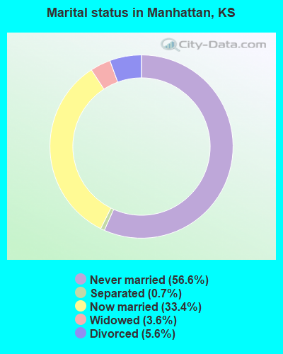
- Never married: 56.6%
- Now married: 33.4%
- Separated: 0.7%
- Widowed: 3.6%
- Divorced: 5.6%
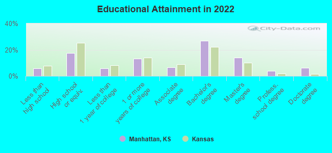
For population 25 years and over in Manhattan:
- High school or higher: 95.2%
- Bachelor's degree or higher: 52.6%
- Graduate or professional degree: 25.0%
- Unemployed: 7.4%
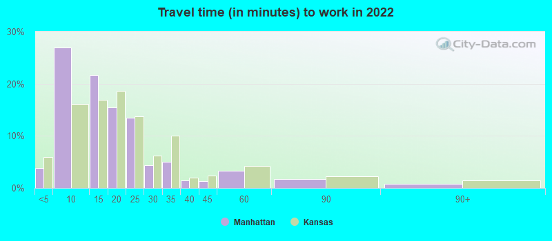
- Mean travel time to work (commute): 13.2 minutes
| Here: | 12.2 |
| Kansas average: | 11.5 |
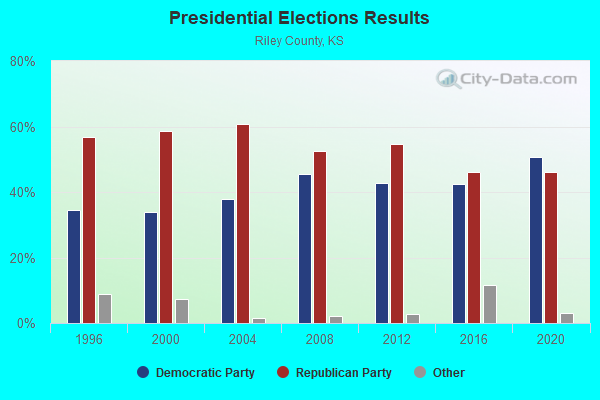
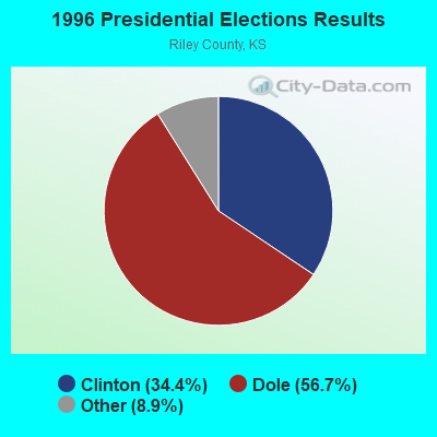
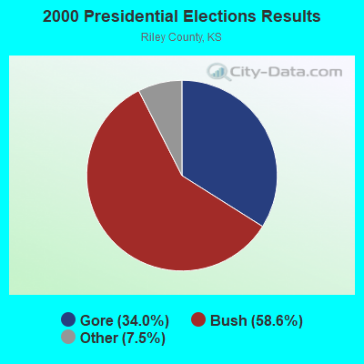
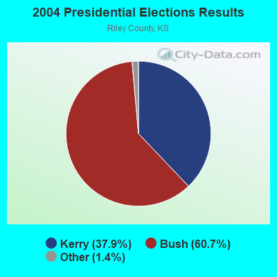
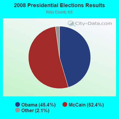
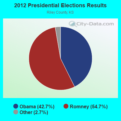
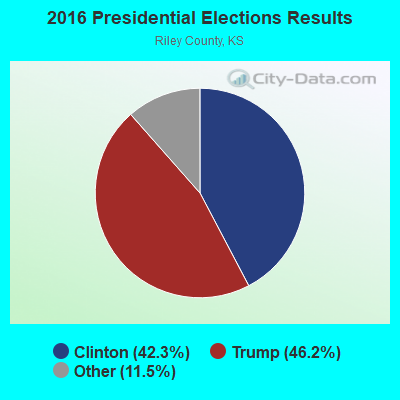
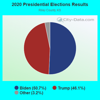
Graphs represent county-level data. Detailed 2008 Election Results
Religion statistics for Manhattan, KS (based on Riley County data)
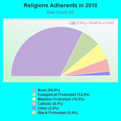
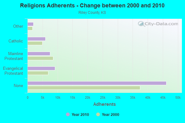
| Religion | Adherents | Congregations |
|---|---|---|
| Evangelical Protestant | 9,144 | 45 |
| Mainline Protestant | 7,522 | 22 |
| Catholic | 5,964 | 4 |
| Other | 1,979 | 9 |
| Black Protestant | 301 | 3 |
| Orthodox | 25 | 1 |
| None | 46,180 | - |
Food Environment Statistics:
| This county: | 0.72 / 10,000 pop. |
| Kansas: | 1.96 / 10,000 pop. |
| This county: | 0.14 / 10,000 pop. |
| Kansas: | 0.51 / 10,000 pop. |
| Riley County: | 3.61 / 10,000 pop. |
| Kansas: | 3.84 / 10,000 pop. |
| This county: | 6.50 / 10,000 pop. |
| Kansas: | 7.33 / 10,000 pop. |
| Riley County: | 5.9% |
| State: | 8.1% |
| Riley County: | 26.4% |
| State: | 27.9% |
| Riley County: | 9.8% |
| Kansas: | 13.4% |
Health and Nutrition:
| Manhattan: | 50.2% |
| State: | 49.2% |
| Manhattan: | 51.4% |
| State: | 46.3% |
| This city: | 27.5 |
| Kansas: | 28.6 |
| Manhattan: | 18.3% |
| State: | 21.2% |
| Manhattan: | 9.7% |
| State: | 10.5% |
| This city: | 6.9 |
| State: | 6.8 |
| Here: | 27.5% |
| Kansas: | 33.5% |
| This city: | 61.1% |
| Kansas: | 56.0% |
| This city: | 82.8% |
| Kansas: | 78.6% |
More about Health and Nutrition of Manhattan, KS Residents
| Local government employment and payroll (March 2022) | |||||
| Function | Full-time employees | Monthly full-time payroll | Average yearly full-time wage | Part-time employees | Monthly part-time payroll |
|---|---|---|---|---|---|
| Parks and Recreation | 78 | $349,195 | $53,722 | 93 | $48,798 |
| Firefighters | 70 | $412,858 | $70,776 | 3 | $3,209 |
| Sewerage | 52 | $243,848 | $56,273 | 0 | $0 |
| Streets and Highways | 49 | $245,383 | $60,094 | 0 | $0 |
| Water Supply | 40 | $186,297 | $55,889 | 0 | $0 |
| Other Government Administration | 23 | $138,090 | $72,047 | 7 | $3,941 |
| Financial Administration | 21 | $100,819 | $57,611 | 2 | $1,291 |
| Fire - Other | 20 | $105,517 | $63,310 | 0 | $0 |
| Airports | 17 | $75,067 | $52,988 | 0 | $0 |
| Judicial and Legal | 16 | $95,750 | $71,813 | 0 | $0 |
| Other and Unallocable | 12 | $55,822 | $55,822 | 0 | $0 |
| Housing and Community Development (Local) | 8 | $47,857 | $71,786 | 2 | $1,284 |
| Health | 8 | $27,284 | $40,926 | 3 | $2,662 |
| Totals for Government | 414 | $2,083,787 | $60,400 | 110 | $61,185 |
Manhattan government finances - Expenditure in 2021 (per resident):
- Current Operations - General - Other: $23,845,000 ($442.98)
Water Utilities: $11,561,000 ($214.77)
Sewerage: $8,750,000 ($162.55)
Parks and Recreation: $6,770,000 ($125.77)
Local Fire Protection: $6,180,000 ($114.81)
Regular Highways: $4,111,000 ($76.37)
Libraries: $3,468,000 ($64.43)
Judicial and Legal Services: $1,318,000 ($24.48)
Financial Administration: $1,034,000 ($19.21)
Central Staff Services: $1,003,000 ($18.63)
Housing and Community Development: $938,000 ($17.43)
Protective Inspection and Regulation - Other: $883,000 ($16.40)
Health - Other: $523,000 ($9.72)
General Public Buildings: $354,000 ($6.58)
- General - Interest on Debt: $7,888,000 ($146.54)
- Intergovernmental to Local - Other - Police Protection: $35,362,000 ($656.93)
- Intergovernmental to State - Regular Highways: $134,000 ($2.49)
- Other Capital Outlay - Regular Highways: $1,993,000 ($37.02)
Sewerage: $966,000 ($17.95)
Water Utilities: $447,000 ($8.30)
Miscellaneous Commercial Activities - Other: $123,000 ($2.29)
Judicial and Legal Services: $45,000 ($0.84)
Parks and Recreation: $25,000 ($0.46)
Protective Inspection and Regulation - Other: $2,000 ($0.04)
- Total Salaries and Wages: $23,189,000 ($430.79)
Manhattan government finances - Revenue in 2021 (per resident):
- Charges - Sewerage: $14,467,000 ($268.76)
Air Transportation: $516,000 ($9.59)
Other: $499,000 ($9.27)
Parks and Recreation: $188,000 ($3.49)
Miscellaneous Commercial Activities: $123,000 ($2.29)
- Federal Intergovernmental - Other: $2,999,000 ($55.71)
Natural Resources: $1,182,000 ($21.96)
Air Transportation: $1,108,000 ($20.58)
Sewerage: $802,000 ($14.90)
Housing and Community Development: $674,000 ($12.52)
- Local Intergovernmental - Highways: $1,576,000 ($29.28)
General Local Government Support: $72,000 ($1.34)
- Miscellaneous - Special Assessments: $8,352,000 ($155.16)
General Revenue - Other: $2,005,000 ($37.25)
Donations From Private Sources: $2,001,000 ($37.17)
Rents: $922,000 ($17.13)
Fines and Forfeits: $633,000 ($11.76)
Interest Earnings: $285,000 ($5.29)
Sale of Property: $193,000 ($3.59)
- Revenue - Water Utilities: $11,235,000 ($208.72)
- State Intergovernmental - Highways: $2,941,000 ($54.64)
General Local Government Support: $1,088,000 ($20.21)
- Tax - Property: $31,158,000 ($578.83)
General Sales and Gross Receipts: $24,087,000 ($447.47)
Other Selective Sales: $4,796,000 ($89.10)
Other License: $436,000 ($8.10)
Public Utilities Sales: $211,000 ($3.92)
Occupation and Business License - Other: $78,000 ($1.45)
Alcoholic Beverage License: $22,000 ($0.41)
Manhattan government finances - Debt in 2021 (per resident):
- Long Term Debt - Beginning Outstanding - Unspecified Public Purpose: $139,990,000 ($2600.64)
Outstanding Unspecified Public Purpose: $133,291,000 ($2476.19)
Outstanding Nonguaranteed - Industrial Revenue: $59,649,000 ($1108.12)
Beginning Outstanding - Public Debt for Private Purpose: $57,200,000 ($1062.62)
Retired Unspecified Public Purpose: $22,362,000 ($415.43)
Issue, Unspecified Public Purpose: $15,663,000 ($290.98)
Issue, Nonguaranteed - Public Debt for Private Purpose: $7,696,000 ($142.97)
Retired Nonguaranteed - Public Debt for Private Purpose: $5,247,000 ($97.48)
- Short Term Debt Outstanding - End of Fiscal Year: $76,880,000 ($1428.23)
Beginning: $41,940,000 ($779.13)
Manhattan government finances - Cash and Securities in 2021 (per resident):
- Other Funds - Cash and Securities: $66,916,000 ($1243.12)
- Sinking Funds - Cash and Securities: $62,369,000 ($1158.65)
14.39% of this county's 2021 resident taxpayers lived in other counties in 2020 ($48,204 average adjusted gross income)
| Here: | 14.39% |
| Kansas average: | 6.64% |
0.32% of residents moved from foreign countries ($1,145 average AGI)
Riley County: 0.32% Kansas average: 0.04%
Top counties from which taxpayers relocated into this county between 2020 and 2021:
| from Geary County, KS | |
| from Pottawatomie County, KS | |
| from Sedgwick County, KS |
16.20% of this county's 2020 resident taxpayers moved to other counties in 2021 ($49,359 average adjusted gross income)
| Here: | 16.20% |
| Kansas average: | 6.88% |
0.17% of residents moved to foreign countries ($682 average AGI)
Riley County: 0.17% Kansas average: 0.03%
Top counties to which taxpayers relocated from this county between 2020 and 2021:
| to Geary County, KS | |
| to Pottawatomie County, KS | |
| to Johnson County, KS |
| Businesses in Manhattan, KS | ||||
| Name | Count | Name | Count | |
|---|---|---|---|---|
| ALDI | 1 | Kroger | 3 | |
| AT&T | 2 | La-Z-Boy | 1 | |
| Ace Hardware | 1 | Lane Furniture | 1 | |
| Aeropostale | 1 | Little Caesars Pizza | 1 | |
| American Eagle Outfitters | 1 | Long John Silver's | 1 | |
| Applebee's | 1 | Marriott | 1 | |
| Arby's | 2 | MasterBrand Cabinets | 2 | |
| Ashley Furniture | 1 | Maurices | 1 | |
| AutoZone | 1 | Mazda | 1 | |
| Baskin-Robbins | 1 | McDonald's | 2 | |
| Bath & Body Works | 1 | Motel 6 | 1 | |
| Bed Bath & Beyond | 1 | New Balance | 3 | |
| Best Western | 1 | Nike | 11 | |
| Blockbuster | 1 | Nissan | 1 | |
| Buffalo Wild Wings | 1 | Olive Garden | 1 | |
| Burger King | 2 | Pac Sun | 1 | |
| Caribou Coffee | 2 | Panda Express | 1 | |
| Chevrolet | 1 | Panera Bread | 1 | |
| Chick-Fil-A | 1 | Papa John's Pizza | 1 | |
| Clarion | 1 | Payless | 1 | |
| Cold Stone Creamery | 1 | Penske | 1 | |
| Comfort Suites | 1 | Pier 1 Imports | 1 | |
| Curves | 1 | Pizza Hut | 3 | |
| DHL | 1 | Quality | 1 | |
| Dairy Queen | 2 | Quiznos | 2 | |
| Domino's Pizza | 1 | RadioShack | 1 | |
| Dressbarn | 1 | Rue21 | 1 | |
| FedEx | 7 | SAS Shoes | 1 | |
| Finish Line | 1 | SONIC Drive-In | 2 | |
| Firestone Complete Auto Care | 1 | Sears | 3 | |
| Foot Locker | 1 | Spencer Gifts | 1 | |
| Ford | 1 | Sprint Nextel | 2 | |
| GNC | 2 | Staples | 1 | |
| GameStop | 2 | Starbucks | 2 | |
| Gap | 1 | Subway | 6 | |
| H&R Block | 3 | Super 8 | 1 | |
| Hilton | 1 | T-Mobile | 4 | |
| Hobby Lobby | 1 | Taco Bell | 2 | |
| Holiday Inn | 1 | Target | 1 | |
| Hollister Co. | 1 | Toyota | 1 | |
| Home Depot | 1 | Toys"R"Us | 1 | |
| Honda | 1 | True Value | 2 | |
| Hot Topic | 1 | U-Haul | 3 | |
| Houlihan's | 1 | U.S. Cellular | 2 | |
| IHOP | 1 | UPS | 10 | |
| JCPenney | 1 | Vans | 2 | |
| Jimmy Jazz | 2 | Verizon Wireless | 2 | |
| Jimmy John's | 1 | Victoria's Secret | 1 | |
| Journeys | 1 | Walgreens | 2 | |
| Justice | 1 | Walmart | 1 | |
| Kmart | 1 | Wendy's | 2 | |
Strongest AM radio stations in Manhattan:
- KMAN (1350 AM; 0 kW; MANHATTAN, KS; Owner: MANHATTAN BROADCASTING CO., INC.)
- WHB (810 AM; 50 kW; KANSAS CITY, MO; Owner: UNION BROADCASTING, INC.)
- WIBW (580 AM; 5 kW; TOPEKA, KS; Owner: MCC RADIO, LLC)
- KOIL (1020 AM; 50 kW; PLATTSMOUTH, NE; Owner: WAITT RADIO, INC.)
- KJCK (1420 AM; 1 kW; JUNCTION CITY, KS; Owner: PLATINUM BROADCASTING CO., INC.)
- KFAB (1110 AM; 50 kW; OMAHA, NE; Owner: CAPSTAR TX LIMITED PARTNERSHIP)
- KFRM (550 AM; 5 kW; SALINA, KS; Owner: TAYLOR COMMUNICATIONS, INC.)
- KKAR (1290 AM; 50 kW; OMAHA, NE; Owner: WAITT RADIO, INC.)
- KRVN (880 AM; 50 kW; LEXINGTON, NE; Owner: NEBRASKA RURAL RADIO ASSOCIATION)
- KKHK (1250 AM; 25 kW; KANSAS CITY, KS)
- KSAL (1150 AM; 5 kW; SALINA, KS; Owner: EBC INC.)
- KRMG (740 AM; 50 kW; TULSA, OK; Owner: CXR HOLDINGS, INC.)
- KMAJ (1440 AM; 5 kW; TOPEKA, KS; Owner: CUMULUS LICENSING CORP.)
Strongest FM radio stations in Manhattan:
- KACZ (96.3 FM; RILEY, KS; Owner: MANHATTAN BROADCASTING CO., INC.)
- KQLA (103.5 FM; OGDEN, KS; Owner: PLATINUM BROADCASTING COMPANY)
- KSDB-FM (91.9 FM; MANHATTAN, KS; Owner: KANSAS STATE UNIVERSITY)
- KMKF (101.5 FM; MANHATTAN, KS; Owner: MANHATTAN BROADCASTING CO., INC.)
- KXBZ (104.7 FM; MANHATTAN, KS; Owner: MANHATTAN BROADCASTING CO., INC.)
- KJCK-FM (97.5 FM; JUNCTION CITY, KS; Owner: PLATINUM BROADCASTING CO., INC.)
- KHCA (95.3 FM; WAMEGO, KS; Owner: KHCA, INC.)
- WIBW-FM (94.5 FM; TOPEKA, KS; Owner: MCC RADIO, LLC)
- KMAJ-FM (107.7 FM; TOPEKA, KS; Owner: CUMULUS LICENSING CORP.)
- KTPK (106.9 FM; TOPEKA, KS; Owner: KANSAS CAPITAL BROADCASTING, INC.)
- KBLS (102.5 FM; NORTH FORT RILEY, KS; Owner: EBC, INC.)
- KBUZ (90.3 FM; TOPEKA, KS; Owner: AMERICAN FAMILY ASSOCIATION, INC.)
- KDVV (100.3 FM; TOPEKA, KS; Owner: CUMULUS LICENSING CORP.)
- KANV (91.3 FM; OLSBURG, KS; Owner: THE UNIVERSITY OF KANSAS)
- K214CZ (90.7 FM; MANHATTAN, KS; Owner: PENSACOLA CHRISTIAN COLLEGE, INC.)
TV broadcast stations around Manhattan:
- KKSU-LP (Channel 21; MANHATTAN, KS; Owner: KANSAS STATE UNIVERSITY)
- K31BW (Channel 31; MANHATTAN, KS; Owner: TRINITY BROADCASTING NETWORK)
- KMJT-CA (Channel 15; OGDEN, KS; Owner: MONTGOMERY COMMUNICATIONS, INC.)
- WIBW-TV (Channel 13; TOPEKA, KS; Owner: GRAY MIDAMERICA TV LICENSEE CORP.)
- KTKA-TV (Channel 49; TOPEKA, KS; Owner: NORTHEAST KANSAS BROADCAST SERVICE, INC.)
- K25DS (Channel 25; JUNCTION CITY, KS; Owner: TRINITY BROADCASTING NETWORK)
- K39BR (Channel 39; JUNCTION CITY, KS; Owner: NORTHEAST KANSAS B/CST.SERVICE,INC.)
- KSNT (Channel 27; TOPEKA, KS; Owner: EMMIS TELEVISION LICENSE CORPORATION OF TOPEKA)
- KTLJ-CA (Channel 6; JUNCTION CITY, KS; Owner: MONTGOMERY COMMUNICATIONS, INC.)
- National Bridge Inventory (NBI) Statistics
- 70Number of bridges
- 945ft / 288mTotal length
- $4,947,000Total costs
- 292,179Total average daily traffic
- 10,732Total average daily truck traffic
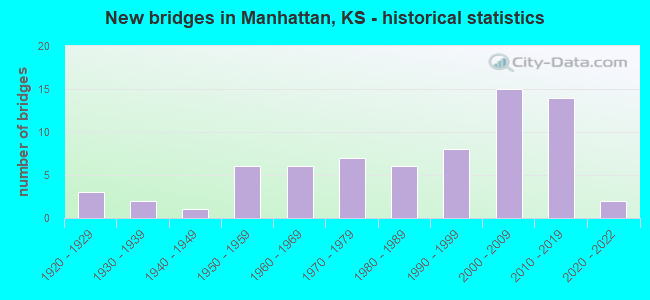
- New bridges - historical statistics
- 31920-1929
- 21930-1939
- 11940-1949
- 61950-1959
- 61960-1969
- 71970-1979
- 61980-1989
- 81990-1999
- 152000-2009
- 142010-2019
- 22020-2022
FCC Registered Antenna Towers: 205 (See the full list of FCC Registered Antenna Towers)
FCC Registered Commercial Land Mobile Towers: 5 (See the full list of FCC Registered Commercial Land Mobile Towers in Manhattan, KS)
FCC Registered Private Land Mobile Towers: 4 (See the full list of FCC Registered Private Land Mobile Towers)
FCC Registered Broadcast Land Mobile Towers: 37 (See the full list of FCC Registered Broadcast Land Mobile Towers)
FCC Registered Microwave Towers: 58 (See the full list of FCC Registered Microwave Towers in this town)
FCC Registered Paging Towers: 6 (See the full list of FCC Registered Paging Towers)
FCC Registered Maritime Coast & Aviation Ground Towers: 8 (See the full list of FCC Registered Maritime Coast & Aviation Ground Towers)
FCC Registered Amateur Radio Licenses: 324 (See the full list of FCC Registered Amateur Radio Licenses in Manhattan)
FAA Registered Aircraft Manufacturers and Dealers: 1 (See the full list of FAA Registered Manufacturers and Dealers in Manhattan)
FAA Registered Aircraft: 81 (See the full list of FAA Registered Aircraft)
| Home Mortgage Disclosure Act Aggregated Statistics For Year 2009 (Based on 5 full and 9 partial tracts) | ||||||||||||||
| A) FHA, FSA/RHS & VA Home Purchase Loans | B) Conventional Home Purchase Loans | C) Refinancings | D) Home Improvement Loans | E) Loans on Dwellings For 5+ Families | F) Non-occupant Loans on < 5 Family Dwellings (A B C & D) | G) Loans On Manufactured Home Dwelling (A B C & D) | ||||||||
|---|---|---|---|---|---|---|---|---|---|---|---|---|---|---|
| Number | Average Value | Number | Average Value | Number | Average Value | Number | Average Value | Number | Average Value | Number | Average Value | Number | Average Value | |
| LOANS ORIGINATED | 97 | $166,963 | 163 | $134,519 | 425 | $165,417 | 65 | $75,060 | 16 | $706,901 | 180 | $146,157 | 10 | $21,605 |
| APPLICATIONS APPROVED, NOT ACCEPTED | 2 | $146,565 | 15 | $131,492 | 37 | $161,504 | 3 | $59,430 | 0 | $0 | 7 | $121,430 | 2 | $30,990 |
| APPLICATIONS DENIED | 8 | $150,216 | 21 | $4,870,883 | 81 | $157,479 | 8 | $64,166 | 1 | $660,000 | 9 | $11,228,130 | 9 | $42,473 |
| APPLICATIONS WITHDRAWN | 3 | $186,103 | 9 | $106,469 | 56 | $157,162 | 3 | $134,760 | 2 | $1,634,000 | 5 | $117,554 | 0 | $0 |
| FILES CLOSED FOR INCOMPLETENESS | 0 | $0 | 0 | $0 | 8 | $176,888 | 0 | $0 | 0 | $0 | 0 | $0 | 0 | $0 |
Detailed mortgage data for all 11 tracts in Manhattan, KS
| Private Mortgage Insurance Companies Aggregated Statistics For Year 2009 (Based on 5 full and 9 partial tracts) | ||||||
| A) Conventional Home Purchase Loans | B) Refinancings | C) Non-occupant Loans on < 5 Family Dwellings (A & B) | ||||
|---|---|---|---|---|---|---|
| Number | Average Value | Number | Average Value | Number | Average Value | |
| LOANS ORIGINATED | 37 | $170,668 | 20 | $176,250 | 2 | $114,500 |
| APPLICATIONS APPROVED, NOT ACCEPTED | 5 | $138,612 | 3 | $229,743 | 0 | $0 |
| APPLICATIONS DENIED | 7 | $173,013 | 2 | $167,290 | 1 | $107,280 |
| APPLICATIONS WITHDRAWN | 1 | $121,060 | 3 | $148,823 | 0 | $0 |
| FILES CLOSED FOR INCOMPLETENESS | 2 | $137,500 | 0 | $0 | 0 | $0 |
2002 - 2018 National Fire Incident Reporting System (NFIRS) incidents
- Fire incident types reported to NFIRS in Manhattan, KS
- 1,81253.4%Outside Fires
- 99629.3%Structure Fires
- 53615.8%Mobile Property/Vehicle Fires
- 511.5%Other
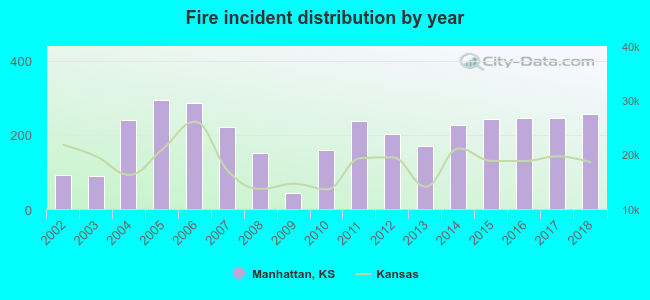 According to the data from the years 2002 - 2018 the average number of fire incidents per year is 200. The highest number of fires - 293 took place in 2005, and the least - 42 in 2009. The data has a growing trend.
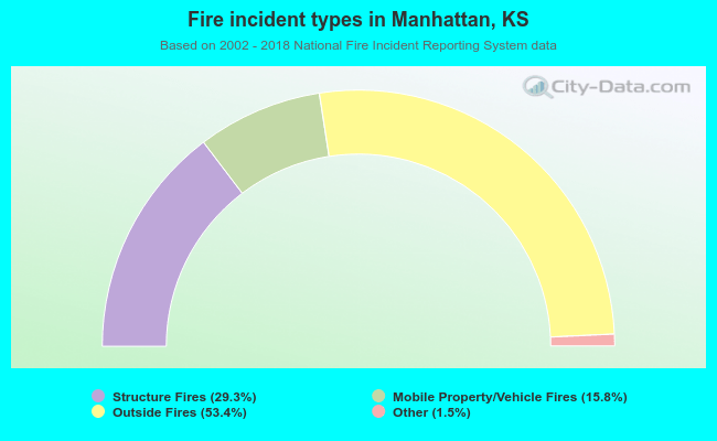 When looking into fire subcategories, the most incidents belonged to: Outside Fires (53.4%), and Structure Fires (29.3%).
Fire-safe hotels and motels in Manhattan, Kansas:
- Four Points by Sheraton Manhattan Kansas, 530 Richards Dr, Manhattan, Kansas 66502 , Phone: (785) 539-5311, Fax: (785) 539-8368
- Super 8 Motel - Manhattan, 200 Tuttle Creek Blvd, Manhattan, Kansas 66502 , Phone: (785) 537-8468, Fax: (785) 537-9216
- Fairfield Inn, 300 Colorado St, Manhattan, Kansas 66502 , Phone: (785) 539-2400, Fax: (785) 539-1483
- Americas Best Value Inn, 1501 Tuttle Creek Blvd, Manhattan, Kansas 66502 , Phone: (785) 539-5391, Fax: (785) 539-0847
- Best Western Manhattan Inn, 601 E Poyntz Ave, Manhattan, Kansas 66502 , Phone: (785) 537-8300, Fax: (785) 537-8303
- Hilton Garden Inn, 410 S 3rd St, Manhattan, Kansas 66502 , Phone: (785) 532-9116, Fax: (785) 532-9136
- Parkwood Inn & Suites, 505 S 17th St, Manhattan, Kansas 66502 , Phone: (785) 320-5440, Fax: (785) 320-5448
- Candlewood Suites Manhattan, 210 Blue Earth Pl, Manhattan, Kansas 66502 , Phone: (785) 320-7995, Fax: (785) 320-7994
- 2 other hotels and motels
| Most common first names in Manhattan, KS among deceased individuals | ||
| Name | Count | Lived (average) |
|---|---|---|
| William | 153 | 77.5 years |
| John | 150 | 77.7 years |
| Mary | 146 | 81.6 years |
| Robert | 109 | 72.8 years |
| Charles | 108 | 75.7 years |
| James | 105 | 73.3 years |
| Helen | 95 | 81.6 years |
| Ruth | 85 | 83.5 years |
| Dorothy | 80 | 80.7 years |
| George | 75 | 79.8 years |
| Most common last names in Manhattan, KS among deceased individuals | ||
| Last name | Count | Lived (average) |
|---|---|---|
| Smith | 78 | 78.0 years |
| Johnson | 72 | 76.3 years |
| Nelson | 48 | 78.3 years |
| Miller | 45 | 81.0 years |
| Wilson | 42 | 77.4 years |
| Brown | 41 | 80.8 years |
| Anderson | 40 | 77.8 years |
| Jones | 33 | 77.0 years |
| Thompson | 31 | 78.0 years |
| Taylor | 30 | 82.7 years |
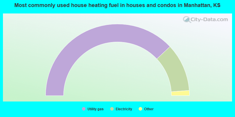
- 76.1%Utility gas
- 21.7%Electricity
- 1.2%Bottled, tank, or LP gas
- 0.4%No fuel used
- 0.4%Wood
- 0.2%Other fuel
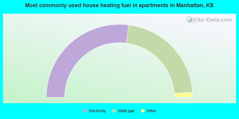
- 54.0%Electricity
- 43.8%Utility gas
- 1.5%Bottled, tank, or LP gas
- 0.6%Other fuel
- 0.1%No fuel used
Manhattan compared to Kansas state average:
- Unemployed percentage below state average.
- Median age significantly below state average.
- Renting percentage above state average.
- Length of stay since moving in above state average.
- Number of college students significantly above state average.
- Percentage of population with a bachelor's degree or higher above state average.
Manhattan on our top lists:
- #4 on the list of "Top 100 cities with highest percentage of college students (pop. 50,000+)"
- #5 on the list of "Top 101 cities with largest percentage of workers with very short commute times (9 minutes or less) (population 50,000+)"
- #5 on the list of "Top 101 cities with largest percentage of females in industries: educational services (population 50,000+)"
- #9 on the list of "Top 100 cities with youngest residents (pop. 50,000+)"
- #9 on the list of "Top 100 cities with shortest commuting times (pop. 50,000+)"
- #14 on the list of "Top 101 cities with largest percentage of females in occupations: education, training, and library occupations (population 50,000+)"
- #14 on the list of "Top 101 cities with largest percentage of males in industries: educational services (population 50,000+)"
- #16 on the list of "Top 101 cities with largest percentage of males in occupations: education, training, and library occupations (population 50,000+)"
- #27 on the list of "Top 101 cities with the most people having Doctorate degrees (population 50,000+)"
- #30 on the list of "Top 101 cities with largest percentage of males in occupations: life, physical, and social science occupations (population 50,000+)"
- #32 on the list of "Top 101 cities where the highest percentage of males (15+ years) which never married (with at least 10,000 males in this group)"
- #34 on the list of "Top 101 cities where the highest percentage of females (15+ years) which never married (with at least 10,000 females in this group)"
- #41 on the list of "Top 100 cities with the largest percentage of males (pop. 50,000+)"
- #42 on the list of "Top 101 cities with the largest percentage of people in military transient quarters for temporary residents (population 1,000+)"
- #46 on the list of "Top 101 cities with largest percentage of females in occupations: farming, fishing, and forestry occupations (population 50,000+)"
- #51 on the list of "Top 101 cities with largest percentage of females in industries: agriculture, forestry, fishing and hunting (population 50,000+)"
- #55 on the list of "Top 100 cities with highest percentage of renters (pop. 50,000+)"
- #58 on the list of "Top 101 cities with the largest temperature differences during a year (population 50,000+)"
- #60 on the list of "Top 100 cities with strongest arts, entertainment, recreation, accommodation and food services industries (pop. 50,000+)"
- #67 on the list of "Top 101 cities with largest percentage of females in occupations: food preparation and serving related occupations (population 50,000+)"
- #6 on the list of "Top 101 counties with the lowest percentage of residents that smoked 100+ cigarettes in their lives"
- #12 on the list of "Top 101 counties with the highest percentage of residents relocating from other counties between 2010 and 2011"
- #13 on the list of "Top 101 counties with the highest percentage of residents relocating to other counties in 2011"
- #15 on the list of "Top 101 counties with the lowest number of deaths per 1000 residents 2007-2013 (pop. 50,000+)"
- #18 on the list of "Top 101 counties with the highest percentage of residents relocating to foreign countries in 2011 (pop. 50,000+)"

|
|
Total of 328 patent applications in 2008-2024.