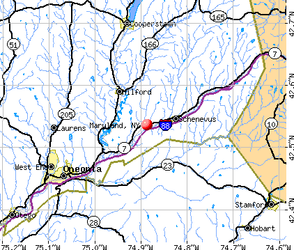
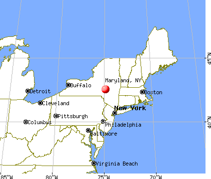
Maryland, New York
Submit your own pictures of this town and show them to the world
- OSM Map
- General Map
- Google Map
- MSN Map
Population change since 2000: -1.2%
 |
| Males: 937 | |
| Females: 960 |
| Median resident age: | 45.4 years |
| New York median age: | 40.7 years |
Zip codes: 12116.
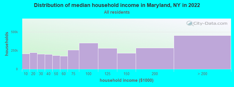
| Maryland: | $65,025 |
| NY: | $79,557 |
Estimated per capita income in 2022: $33,336 (it was $16,120 in 2000)
Maryland town income, earnings, and wages data
Estimated median house or condo value in 2022: $160,502 (it was $68,800 in 2000)
| Maryland: | $160,502 |
| NY: | $400,400 |
Mean prices in 2022: all housing units: $228,779; detached houses: $247,959; townhouses or other attached units: $313,844; in 2-unit structures: $212,590; in 3-to-4-unit structures: $357,277; in 5-or-more-unit structures: $928,498; mobile homes: $87,717
Detailed information about poverty and poor residents in Maryland, NY


- 1,80395.0%White alone
- 492.6%Hispanic
- 251.3%Two or more races
- 170.9%Black alone
- 30.2%Asian alone
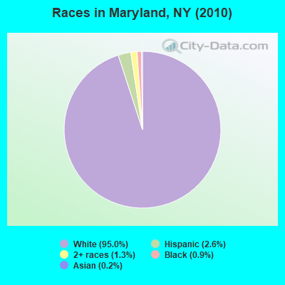
Races in Maryland detailed stats: ancestries, foreign born residents, place of birth
According to our research of New York and other state lists, there were 2 registered sex offenders living in Maryland, New York as of April 27, 2024.
The ratio of all residents to sex offenders in Maryland is 949 to 1.
The ratio of registered sex offenders to all residents in this city is near the state average.
 Recent articles from our blog. Our writers, many of them Ph.D. graduates or candidates, create easy-to-read articles on a wide variety of topics.


Latest news from Maryland, NY collected exclusively by city-data.com from local newspapers, TV, and radio stations
Ancestries: German (20.5%), Irish (14.9%), English (14.2%), Italian (10.4%), United States (8.2%), French (4.2%).
Current Local Time: EST time zone
Elevation: 1220 feet
Land area: 51.8 square miles.
Population density: 37 people per square mile (very low).
51 residents are foreign born (1.7% Europe, 0.6% North America, 0.3% Asia).
| This town: | 2.7% |
| New York: | 20.4% |
| Maryland town: | 2.1% ($1,428) |
| New York: | 1.9% ($2,847) |
Nearest city with pop. 50,000+: Utica, NY  (42.9 miles , pop. 60,651).
Nearest city with pop. 200,000+: Bronx, NY (127.7 miles , pop. 1,332,650).
Nearest cities:
), ), ), ), ), ), )Latitude: 42.54 N, Longitude: 74.86 W
Area code commonly used in this area: 607

| Here: | 4.7% |
| New York: | 4.4% |
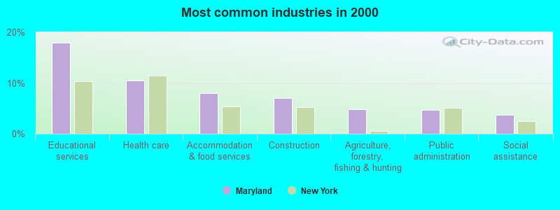
- Educational services (18.0%)
- Health care (10.5%)
- Accommodation & food services (8.0%)
- Construction (7.0%)
- Agriculture, forestry, fishing & hunting (4.8%)
- Public administration (4.7%)
- Social assistance (3.8%)
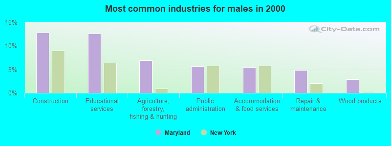
- Construction (12.8%)
- Educational services (12.6%)
- Agriculture, forestry, fishing & hunting (6.9%)
- Public administration (5.7%)
- Accommodation & food services (5.5%)
- Repair & maintenance (4.8%)
- Wood products (2.9%)
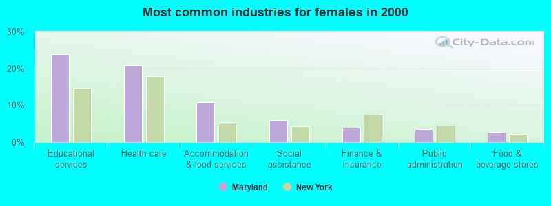
- Educational services (23.9%)
- Health care (20.9%)
- Accommodation & food services (10.8%)
- Social assistance (5.9%)
- Finance & insurance (4.0%)
- Public administration (3.5%)
- Food & beverage stores (2.8%)
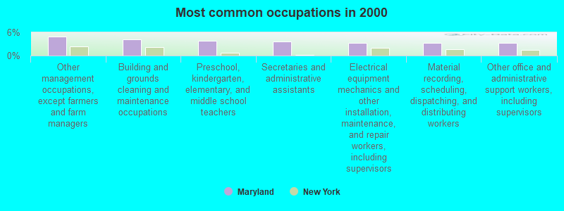
- Other management occupations, except farmers and farm managers (5.0%)
- Building and grounds cleaning and maintenance occupations (4.2%)
- Preschool, kindergarten, elementary, and middle school teachers (3.8%)
- Secretaries and administrative assistants (3.7%)
- Electrical equipment mechanics and other installation, maintenance, and repair workers, including supervisors (3.3%)
- Material recording, scheduling, dispatching, and distributing workers (3.3%)
- Other office and administrative support workers, including supervisors (3.2%)
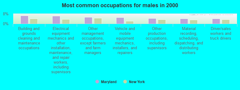
- Building and grounds cleaning and maintenance occupations (6.5%)
- Electrical equipment mechanics and other installation, maintenance, and repair workers, including supervisors (6.3%)
- Other management occupations, except farmers and farm managers (5.3%)
- Vehicle and mobile equipment mechanics, installers, and repairers (5.1%)
- Other production occupations, including supervisors (4.4%)
- Material recording, scheduling, dispatching, and distributing workers (4.2%)
- Driver/sales workers and truck drivers (4.2%)

- Secretaries and administrative assistants (7.7%)
- Preschool, kindergarten, elementary, and middle school teachers (6.1%)
- Other office and administrative support workers, including supervisors (6.1%)
- Other management occupations, except farmers and farm managers (4.7%)
- Health technologists and technicians (4.7%)
- Waiters and waitresses (4.7%)
- Other teachers, instructors, education, training, and library occupations (4.2%)
Average climate in Maryland, New York
Based on data reported by over 4,000 weather stations


Tornado activity:
Maryland-area historical tornado activity is near New York state average. It is 63% smaller than the overall U.S. average.
On 7/10/1989, a category F4 (max. wind speeds 207-260 mph) tornado 26.0 miles away from the Maryland town center injured 20 people and caused between $5,000,000 and $50,000,000 in damages.
On 5/31/1998, a category F3 (max. wind speeds 158-206 mph) tornado 4.6 miles away from the town center injured 3 people and caused $800,000 in damages.
Earthquake activity:
Maryland-area historical earthquake activity is significantly above New York state average. It is 67% smaller than the overall U.S. average.On 10/7/1983 at 10:18:46, a magnitude 5.3 (5.1 MB, 5.3 LG, 5.1 ML, Class: Moderate, Intensity: VI - VII) earthquake occurred 101.0 miles away from Maryland center
On 4/20/2002 at 10:50:47, a magnitude 5.3 (5.3 ML, Depth: 3.0 mi) earthquake occurred 148.2 miles away from the city center
On 4/20/2002 at 10:50:47, a magnitude 5.2 (5.2 MB, 4.2 MS, 5.2 MW, 5.0 MW) earthquake occurred 146.2 miles away from the city center
On 6/17/1991 at 08:53:16, a magnitude 4.1 (4.0 MB, 4.0 LG, Depth: 3.1 mi, Class: Light, Intensity: IV - V) earthquake occurred 11.0 miles away from Maryland center
On 8/23/2011 at 17:51:04, a magnitude 5.8 (5.8 MW, Depth: 3.7 mi) earthquake occurred 359.2 miles away from Maryland center
On 1/19/1982 at 00:14:42, a magnitude 4.7 (4.5 MB, 4.7 MD, 4.5 LG) earthquake occurred 177.5 miles away from Maryland center
Magnitude types: regional Lg-wave magnitude (LG), body-wave magnitude (MB), duration magnitude (MD), local magnitude (ML), surface-wave magnitude (MS), moment magnitude (MW)
Natural disasters:
The number of natural disasters in Otsego County (22) is greater than the US average (15).Major Disasters (Presidential) Declared: 13
Emergencies Declared: 7
Causes of natural disasters: Storms: 10, Floods: 8, Hurricanes: 3, Snowstorms: 2, Tropical Storms: 2, Blizzard: 1, Ice Storm: 1, Power Outage: 1, Tornado: 1, Wind: 1, Winter Storm: 1, Other: 2 (Note: some incidents may be assigned to more than one category).
Hospitals and medical centers near Maryland:
- OTSEGO MANOR (Nursing Home, about 10 miles away; COOPERSTOWN, NY)
- MARY IMOGENE BASSETT HOSPITAL (Dialysis Facility, about 12 miles away; COOPERSTOWN, NY)
- CATSKILL AREA HOSPICE AND PALLIATIVE CARE INC (Hospital, about 12 miles away; ONEONTA, NY)
- A O FOX NH (Nursing Home, about 12 miles away; ONEONTA, NY)
- AT HOME CARE INC CHHA (Home Health Center, about 12 miles away; ONEONTA, NY)
- CHESTNUT PARK AND REHABILITATION NURSING CENTER (Nursing Home, about 14 miles away; ONEONTA, NY)
- BASSETT HEALTHCARE (Dialysis Facility, about 14 miles away; ONEONTA, NY)
Colleges/universities with over 2000 students nearest to Maryland:
- SUNY Oneonta (about 12 miles; Oneonta, NY; Full-time enrollment: 6,081)
- SUNY College of Technology at Delhi (about 20 miles; Delhi, NY; FT enrollment: 2,911)
- SUNY College of Agriculture and Technology at Cobleskill (about 20 miles; Cobleskill, NY; FT enrollment: 2,455)
- Herkimer County Community College (about 35 miles; Herkimer, NY; FT enrollment: 2,774)
- Colgate University (about 40 miles; Hamilton, NY; FT enrollment: 3,094)
- Mohawk Valley Community College (about 42 miles; Utica, NY; FT enrollment: 5,693)
- Fulton-Montgomery Community College (about 42 miles; Johnstown, NY; FT enrollment: 2,043)
Points of interest:
Notable locations in Maryland: Jamaica Dream Farm (A), C H Graham Hose Company (B). Display/hide their locations on the map
Churches in Maryland include: Maryland Baptist Church (A), Word of Faith Church (B). Display/hide their locations on the map
Cemeteries: Bliven Cemetery (1), Spencer Cemetery (2), Maryland Cemetery (3), Elk Creek Cemetery (4), Schenevus Cemetery (5), Platt Cemetery (6), McKown Cemetery (7). Display/hide their locations on the map
Lakes: Mud Lake (A), Seward Lake (B). Display/hide their locations on the map
Streams, rivers, and creeks: Palmer Creek (A), Whitney Brook (B), Potato Creek (C), Elk Creek (D), Sparrowhawk Brook (E), Morehouse Brook (F). Display/hide their locations on the map
Drinking water stations with addresses in Maryland and their reported violations in the past:
REDWOOD INN AND SUITES (Population served: 25, Groundwater):Past monitoring violations:
- One routine major monitoring violation
| This town: | 2.4 people |
| New York: | 2.6 people |
| This town: | 65.7% |
| Whole state: | 63.5% |
| This town: | 10.2% |
| Whole state: | 6.8% |
Likely homosexual households (counted as self-reported same-sex unmarried-partner households)
- Lesbian couples: 0.3% of all households
- Gay men: 0.1% of all households
| This town: | 12.6% |
| Whole state: | 14.6% |
| This town: | 5.0% |
| Whole state: | 7.4% |
For population 15 years and over in Maryland:
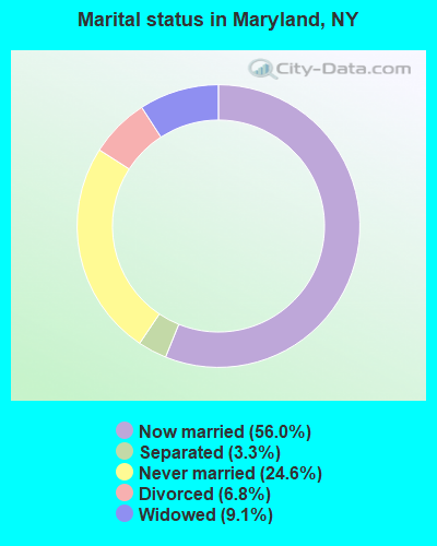
- Never married: 24.6%
- Now married: 56.0%
- Separated: 3.3%
- Widowed: 9.1%
- Divorced: 6.8%
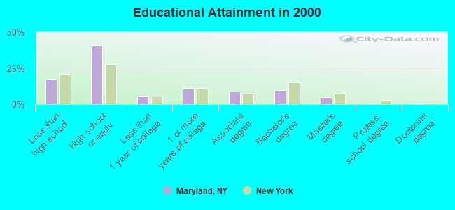
For population 25 years and over in Maryland:
- High school or higher: 82.3%
- Bachelor's degree or higher: 15.6%
- Graduate or professional degree: 5.7%
- Unemployed: 6.4%
- Mean travel time to work (commute): 26.5 minutes
| Here: | 10.8 |
| New York average: | 14.2 |
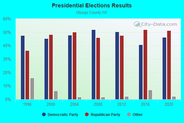
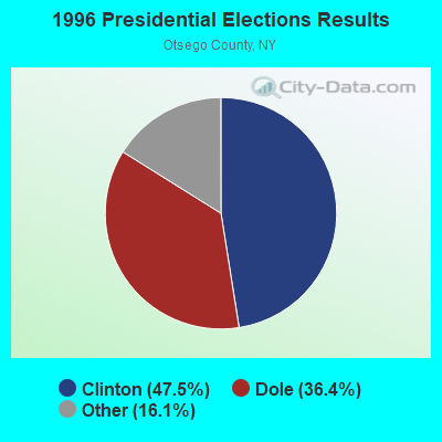
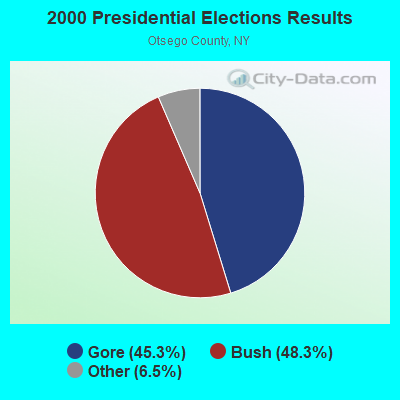
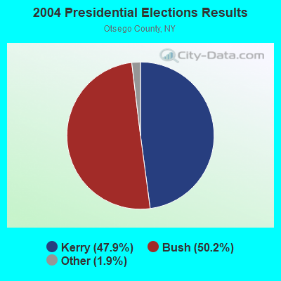
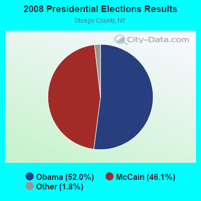
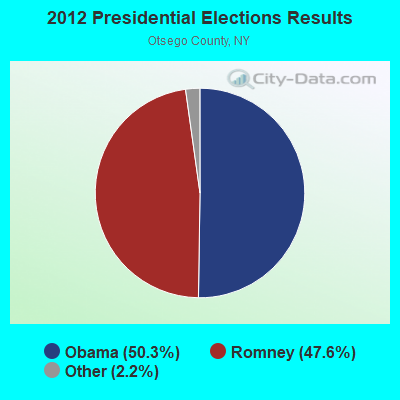
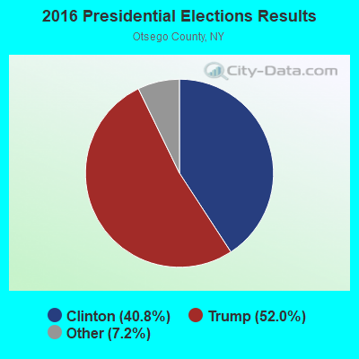
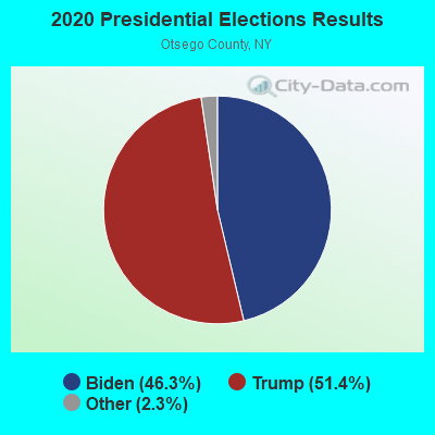
Graphs represent county-level data. Detailed 2008 Election Results
Religion statistics for Maryland, NY (based on Otsego County data)
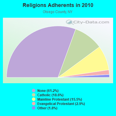
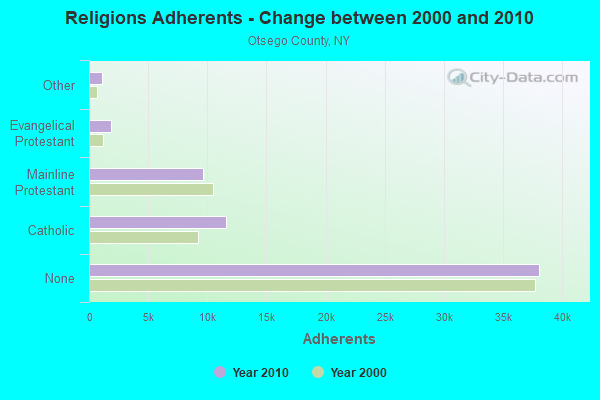
| Religion | Adherents | Congregations |
|---|---|---|
| Catholic | 11,599 | 6 |
| Mainline Protestant | 9,637 | 69 |
| Evangelical Protestant | 1,829 | 26 |
| Other | 1,094 | 9 |
| Orthodox | 25 | 1 |
| None | 38,075 | - |
Food Environment Statistics:
| Here: | 2.89 / 10,000 pop. |
| New York: | 4.13 / 10,000 pop. |
| Here: | 0.32 / 10,000 pop. |
| New York: | 0.06 / 10,000 pop. |
| Otsego County: | 0.96 / 10,000 pop. |
| State: | 0.92 / 10,000 pop. |
| Otsego County: | 5.62 / 10,000 pop. |
| New York: | 1.68 / 10,000 pop. |
| Here: | 9.96 / 10,000 pop. |
| New York: | 8.82 / 10,000 pop. |
| Here: | 7.7% |
| New York: | 8.2% |
| Here: | 24.6% |
| New York: | 23.8% |
| Otsego County: | 15.6% |
| State: | 15.6% |
Strongest AM radio stations in Maryland:
- WGY (810 AM; 50 kW; SCHENECTADY, NY; Owner: CLEAR CHANNEL BROADCASTING LICENSES, INC.)
- WDOS (730 AM; 1 kW; ONEONTA, NY; Owner: ULTIMATE B/CASTING NETWORK, INC.)
- WPTR (1540 AM; 50 kW; ALBANY, NY; Owner: KIMTRON, INC.)
- WNNZ (640 AM; 50 kW; WESTFIELD, MA; Owner: CLEAR CHANNEL BROADCASTING LICENSES, INC.)
- WMCA (570 AM; 50 kW; NEW YORK, NY; Owner: SALEM MEDIA OF NEW YORK, LLC)
- WDLA (1270 AM; 5 kW; WALTON, NY; Owner: BANJO COMMUNICATIONS GROUP, INC.)
- WFAN (660 AM; 50 kW; NEW YORK, NY; Owner: INFINITY BROADCASTING OPERATIONS, INC.)
- WABC (770 AM; 50 kW; NEW YORK, NY; Owner: WABC-AM RADIO, INC.)
- WOR (710 AM; 50 kW; NEW YORK, NY; Owner: BUCKLEY BROADCASTING CORPORATION)
- WCBS (880 AM; 50 kW; NEW YORK, NY; Owner: INFINITY BROADCASTING OPERATIONS, INC.)
- WTIC (1080 AM; 50 kW; HARTFORD, CT; Owner: INFINITY RADIO OPERATIONS INC.)
- WWJZ (640 AM; 50 kW; MOUNT HOLLY, NJ; Owner: ABC, INC.)
- WINS (1010 AM; 50 kW; NEW YORK, NY; Owner: INFINITY BROADCASTING OPERATIONS, INC.)
Strongest FM radio stations in Maryland:
- WGKR (105.3 FM; GRAND GORGE, NY; Owner: SOUND OF LIFE, INC.)
- WDHI (100.3 FM; DELHI, NY; Owner: BANJO COMMUNICATIONS GROUP, INC.)
- WJIV (101.9 FM; CHERRY VALLEY, NY; Owner: CHRISTIAN BROADCASTING SYSTEM, LTD.)
- WSQC-FM (91.7 FM; ONEONTA, NY; Owner: WSKG PUBLIC TELECOMM. COUNCIL)
- WSRK (103.9 FM; ONEONTA, NY; Owner: ULTIMATE B/CASTING NETWORK, INC.)
- WZOZ (103.1 FM; ONEONTA, NY; Owner: BANJO COMMUNICATIONS GROUP, INC)
- WRIP (97.9 FM; WINDHAM, NY; Owner: RIP RADIO, LLC)
- WMYY (97.3 FM; SCHOHARIE, NY; Owner: CAPITAL MEDIA CORPORATION)
- WAMK (90.9 FM; KINGSTON, NY; Owner: W A M C)
- WFGB (89.7 FM; KINGSTON, NY; Owner: SOUND OF LIFE, INC.)
- WBUG-FM (101.1 FM; FORT PLAIN, NY; Owner: ROSER COMMUNICATIONS NETWORK, INC.)
- WAJZ (96.3 FM; VOORHEESVILLE, NY; Owner: 6 JOHNSON ROAD LICENSES, INC.)
- WBKT (95.3 FM; NORWICH, NY; Owner: BANJO COMMUNICATIONS GROUP, INC)
- WDLA-FM (92.1 FM; WALTON, NY; Owner: BANJO COMMUNICATIONS GROUP, INC.)
- WZMR (104.9 FM; ALTAMONT, NY; Owner: 6 JOHNSON ROAD LICENSES, INC.)
- WYJB (95.5 FM; ALBANY, NY; Owner: 6 JOHNSON ROAD LICENSES, INC.)
- WKXZ (93.9 FM; NORWICH, NY; Owner: BANJO COMMUNICATIONS GROUP, INC)
- WGNA-FM (107.7 FM; ALBANY, NY; Owner: REGENT LICENSEE OF MANSFIELD, INC.)
- WCDO-FM (100.9 FM; SIDNEY, NY; Owner: CDO BROADCASTING, INC.)
TV broadcast stations around Maryland:
- WKTV (Channel 2; UTICA, NY; Owner: SMITH TELEVISION OF NEW YORK LICENSE HOLDINGS, INC.)
- WISF-LP (Channel 15; ONEONTA, NY; Owner: RASTUS BROADCAST)
- W29BJ (Channel 29; BURLINGTON, NY; Owner: KEVIN O'KANE)
Maryland fatal accident list:
Jul 15, 2010 12:20 AM, Sr-7, Lat: 42.520919, Lon: -74.914586, Vehicles: 2, Persons: 2, Fatalities: 1
Jul 8, 2002 00:05 AM, Sr-7, Vehicles: 1, Persons: 3, Fatalities: 2, Drunk persons involved: 1
Jun 30, 2000 03:30 PM, Dog Hill Rd., Vehicles: 1, Persons: 1, Fatalities: 1
Feb 8, 1999 08:02 AM, Cr-34, Vehicles: 2, Persons: 2, Fatalities: 1
Apr 24, 1998 06:40 AM, I-88, Vehicles: 1, Persons: 3, Fatalities: 1
- National Bridge Inventory (NBI) Statistics
- 34Number of bridges
- 276ft / 84.3mTotal length
- $53,569,000Total costs
- 47,959Total average daily traffic
- 3,932Total average daily truck traffic
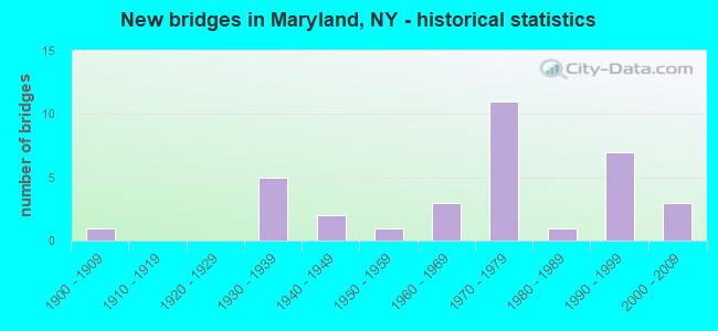
- New bridges - historical statistics
- 11900-1909
- 51930-1939
- 21940-1949
- 11950-1959
- 31960-1969
- 111970-1979
- 11980-1989
- 71990-1999
- 32000-2009
FCC Registered Broadcast Land Mobile Towers:
1- Lat: 42.521028 Lon: -74.909472, Call Sign: WQPH502, Licensee ID: L00063551,
Assigned Frequencies: 160.425 MHz, 161.257 MHz, Grant Date: 05/18/2012, Expiration Date: 05/18/2022, Cancellation Date: 10/06/2015, Certifier: Tom Byers, Registrant: Delaware & Hudson Railway, 120 South 6th Street, Minneapolis, MN 55402, Phone: (612) 904-6093, Fax: (612) 851-5688, Email:
FCC Registered Microwave Towers:
3- HOOKER MT, Dog Hill Road (Lat: 42.597306 Lon: -74.859611), Type: Tower, Structure height: 44.2 m, Call Sign: WML907, Licensee ID: L00128694,
Assigned Frequencies: 2112.00 MHz, Grant Date: 03/15/2011, Expiration Date: 02/01/2021, Cancellation Date: 09/20/2011, Certifier: Michael P Goggin, Registrant: New Cingular Wireless Pcs, LLC
- Linda Pasquale CPE, Lat: 42.533083 Lon: -74.935111, Type: Building, Structure height: 4.8 m, Call Sign: WQJU320,
Assigned Frequencies: 3650.00 MHz, Grant Date: 01/06/2009, Expiration Date: 01/06/2019, Cancellation Date: 03/09/2019, Certifier: Joseph M Lalley, Registrant: Clarity Connect, Inc., 200 Pleasant Grove Road, Ithaca, NY 14850, Phone: (607) 227-5500, Email:
- HOOKER MT, Dog Hill Road (Lat: 42.597222 Lon: -74.860000), Type: Gtower, Structure height: 36.6 m, Call Sign: WQQY215,
Assigned Frequencies: 6785.00 MHz, Grant Date: 03/22/2013, Expiration Date: 03/22/2023, Cancellation Date: 02/16/2016, Certifier: John E Monday, Registrant: At&t Mobility LLC, 3300 E. Renner Road, B3132, Richardson, TX 75082, Phone: (855) 699-7073, Fax: (972) 907-1131, Email:
FCC Registered Amateur Radio Licenses:
12 (See the full list of FCC Registered Amateur Radio Licenses in Maryland)FAA Registered Aircraft:
9 (See the full list of FAA Registered Aircraft in Maryland)| Most common first names in Maryland, NY among deceased individuals | ||
| Name | Count | Lived (average) |
|---|---|---|
| John | 14 | 73.9 years |
| Mary | 13 | 76.0 years |
| William | 12 | 78.3 years |
| George | 12 | 74.7 years |
| Donald | 8 | 72.0 years |
| Frances | 8 | 81.4 years |
| Mildred | 8 | 81.5 years |
| Dorothy | 7 | 77.9 years |
| Helen | 7 | 87.6 years |
| Kenneth | 7 | 75.9 years |
| Most common last names in Maryland, NY among deceased individuals | ||
| Last name | Count | Lived (average) |
|---|---|---|
| Smith | 7 | 75.2 years |
| Miller | 6 | 71.7 years |
| Wilkens | 4 | 78.0 years |
| Johnson | 4 | 74.5 years |
| Dulkis | 4 | 65.7 years |
| Houghton | 4 | 71.0 years |
| Cole | 4 | 79.2 years |
| Hubbard | 4 | 82.2 years |
| Scott | 4 | 74.3 years |
| Yager | 4 | 82.5 years |
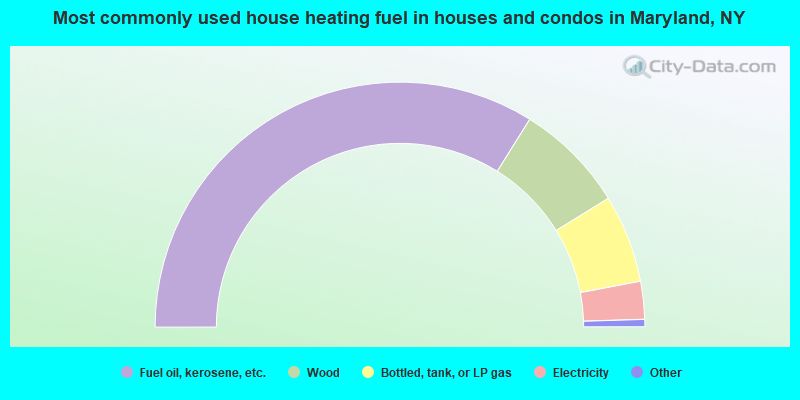
- 67.8%Fuel oil, kerosene, etc.
- 14.6%Wood
- 11.6%Bottled, tank, or LP gas
- 5.0%Electricity
- 0.7%Other fuel
- 0.3%Utility gas
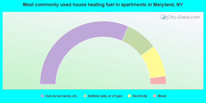
- 63.2%Fuel oil, kerosene, etc.
- 16.4%Bottled, tank, or LP gas
- 16.4%Electricity
- 4.1%Wood
Maryland compared to New York state average:
- Median house value significantly below state average.
- Unemployed percentage below state average.
- Black race population percentage significantly below state average.
- Hispanic race population percentage significantly below state average.
- Median age above state average.
- Foreign-born population percentage significantly below state average.
- Renting percentage significantly below state average.
- Length of stay since moving in significantly above state average.
- Number of rooms per house significantly below state average.
- House age significantly below state average.
- Number of college students below state average.
- Percentage of population with a bachelor's degree or higher below state average.