Newton, Georgia
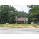
Newton: Newton City Hall
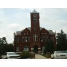
Newton: Historic Baker County Courthouse
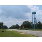
Newton: Looking south down Ga 91
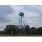
Newton: Newton Water Tower
- add
your
Submit your own pictures of this city and show them to the world
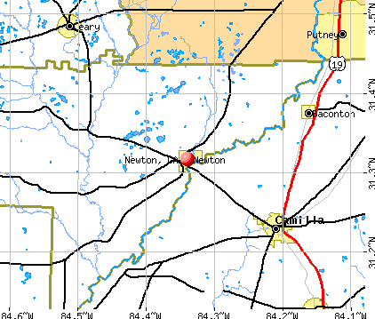
- OSM Map
- General Map
- Google Map
- MSN Map
Population change since 2000: -32.0%
| Males: 273 | |
| Females: 306 |
| Median resident age: | 41.4 years |
| Georgia median age: | 37.6 years |
Zip codes: 39870.
| Newton: | $32,058 |
| GA: | $72,837 |
Estimated per capita income in 2022: $23,484 (it was $13,832 in 2000)
Newton city income, earnings, and wages data
Estimated median house or condo value in 2022: $109,938 (it was $33,800 in 2000)
| Newton: | $109,938 |
| GA: | $297,400 |
Mean prices in 2022: all housing units: $113,104; detached houses: $121,533; mobile homes: $101,630
Median gross rent in 2022: $443.
(8.5% for White Non-Hispanic residents, 84.2% for Black residents, 100.0% for Hispanic or Latino residents)
Detailed information about poverty and poor residents in Newton, GA
Compare current foreclosures near Newton, GA:
| Photo | Address | Area | Beds / Baths | Price | Details |
|---|---|---|---|---|---|

|
#1
Hawkinstown Rd
Newton, GA 39870
|
- sq. feet
|
- baths - beds |
show details | |

|
#2
Jericho Rd
Newton, GA 39870
|
- sq. feet
|
- baths - beds |
show details | |

|
#3
Grace Miller Rd
Newton, GA 39870
|
- sq. feet
|
- baths - beds |
show details | |

|
#4
Newton Hwy
Newton, GA 39870
|
1,470 sq. feet
|
- baths - beds |
show details | |

|
#5
Newton Hwy
Newton, GA 39870
|
1,232 sq. feet
|
- baths - beds |
show details | |

|
#6
John C Durham Rd
Newton, GA 39870
|
- sq. feet
|
- baths - beds |
show details | |

|
#7
Bryant Cir NW
Newton, GA 39870
|
- sq. feet
|
- baths - beds |
show details | |

|
#8
Trice Rd
Newton, GA 39870
|
- sq. feet
|
- baths - beds |
show details | |

|
#9
Oak Haven Dr
Albany, GA 31721
|
1,749 sq. feet
|
2 baths 3 beds |
$31,200
|
show details |

|
#10
Newton Hwy
Newton, GA 39870
|
- sq. feet
|
- baths - beds |
show details |
| Photo | Address | Area | Beds / Baths | Price | Details |
|---|---|---|---|---|---|

|
#11
Coakley Ave
Albany, GA 31721
|
2,133 sq. feet
|
1 baths 3 beds |
show details | |

|
#12
E Broad St
Camilla, GA 31730
|
2,599 sq. feet
|
3 baths 4 beds |
show details | |

|
#13
Strout Ave
Albany, GA 31705
|
1,578 sq. feet
|
2 baths 3 beds |
show details | |

|
#14
Newton Rd
Albany, GA 31721
|
1,698 sq. feet
|
2 baths 3 beds |
show details | |

|
#15
Roland Rd
Albany, GA 31705
|
2,218 sq. feet
|
1 baths 3 beds |
show details | |

|
#16
Pinyon Dr
Albany, GA 31721
|
1,723 sq. feet
|
2 baths 3 beds |
show details | |

|
#17
Nelms Rd
Albany, GA 31705
|
3,097 sq. feet
|
2 baths 4 beds |
show details | |

|
#18
Coakley Ave
Albany, GA 31721
|
2,133 sq. feet
|
1 baths 3 beds |
show details | |

|
#19
Homestead Ave
Albany, GA 31721
|
1,515 sq. feet
|
1 baths 3 beds |
show details | |

|
#20
Aristedes Rd
Albany, GA 31721
|
1,125 sq. feet
|
1 baths 3 beds |
show details |
| Photo | Address | Area | Beds / Baths | Price | Details |
|---|---|---|---|---|---|

|
#21
Shelton Dr
Albany, GA 31705
|
1,415 sq. feet
|
2 baths 3 beds |
show details | |

|
#22
Lily Pond Rd
Albany, GA 31701
|
2,038 sq. feet
|
2 baths 4 beds |
show details | |

|
#23
Leary Rd
Albany, GA 31721
|
2,519 sq. feet
|
2 baths 4 beds |
show details | |

|
#24
Shelton Dr
Albany, GA 31705
|
1,826 sq. feet
|
2 baths 3 beds |
show details | |

|
#25
Wacaser Rd # A
Colquitt, GA 39837
|
1,812 sq. feet
|
1 baths 3 beds |
show details | |

|
#26
Wacaser Rd
Colquitt, GA 39837
|
1,596 sq. feet
|
1 baths 3 beds |
show details | |

|
#27
Stagecoach Rd
Albany, GA 31705
|
1,470 sq. feet
|
1 baths 3 beds |
show details | |

|
#28
Nichols St
Albany, GA 31705
|
1,425 sq. feet
|
1 baths 3 beds |
show details | |

|
#29
Stagecoach Rd
Albany, GA 31705
|
1,392 sq. feet
|
2 baths 3 beds |
show details | |

|
#30
Cooper St
Albany, GA 31705
|
1,125 sq. feet
|
1 baths 3 beds |
show details |
| Photo | Address | Area | Beds / Baths | Price | Details |
|---|---|---|---|---|---|

|
#31
Kennedy St
Camilla, GA 31730
|
960 sq. feet
|
1 baths - beds |
show details | |

|
#32
Ga Highway 65
Pelham, GA 31779
|
1,800 sq. feet
|
1 baths - beds |
show details | |

|
#33
Old Newton Rd
Camilla, GA 31730
|
1,440 sq. feet
|
1 baths - beds |
show details | |

|
#34
Pipeline Rd
Camilla, GA 31730
|
1,350 sq. feet
|
1 baths - beds |
show details | |

|
#35
Ga Highway 37
Camilla, GA 31730
|
2,428 sq. feet
|
1 baths - beds |
show details | |

|
#36
Newton Rd
Camilla, GA 31730
|
1,127 sq. feet
|
1 baths - beds |
show details | |

|
#37
Shady Rd # 1
Baconton, GA 31716
|
1,056 sq. feet
|
1 baths - beds |
show details | |

|
#38
Dogwood St
Camilla, GA 31730
|
1,080 sq. feet
|
1 baths - beds |
show details | |

|
#39
Jerusalem Church Rd
Camilla, GA 31730
|
996 sq. feet
|
1 baths - beds |
show details | |

|
#40
Wiregrass Rd
Camilla, GA 31730
|
1,633 sq. feet
|
1 baths - beds |
show details |
| Photo | Address | Area | Beds / Baths | Price | Details |
|---|---|---|---|---|---|

|
#41
Hollingsworth St NE
Pelham, GA 31779
|
1,025 sq. feet
|
1 baths - beds |
show details | |

|
#42
Hilltop Cir
Camilla, GA 31730
|
1,844 sq. feet
|
1 baths - beds |
show details | |

|
#43
Bradley Ln
Baconton, GA 31716
|
1,375 sq. feet
|
1 baths - beds |
show details | |

|
#44
Shiver Dr
Camilla, GA 31730
|
1,232 sq. feet
|
1 baths - beds |
show details | |

|
#45
N Jackson St
Baconton, GA 31716
|
1,062 sq. feet
|
1 baths - beds |
show details | |

|
#46
Goodson Rd
Camilla, GA 31730
|
988 sq. feet
|
1 baths - beds |
show details | |

|
#47
Cedar Ln
Camilla, GA 31730
|
1,374 sq. feet
|
1 baths - beds |
show details | |

|
#48
Pine St
Camilla, GA 31730
|
1,300 sq. feet
|
1 baths - beds |
show details | |

|
#49
Thomas St
Camilla, GA 31730
|
1,566 sq. feet
|
1 baths - beds |
show details | |

|
Check over 1 million property listings on Foreclosure.com!
|
browse all offers | |||


- 29357.2%White alone
- 19237.5%Black alone
- 81.6%Two or more races
- 71.4%Asian alone
- 40.8%Hispanic
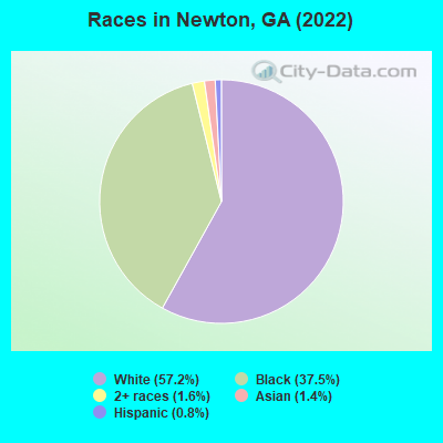
Races in Newton detailed stats: ancestries, foreign born residents, place of birth
According to our research of Georgia and other state lists, there were 19 registered sex offenders living in Newton, Georgia as of April 28, 2024.
The ratio of all residents to sex offenders in Newton is 42 to 1.
Type |
2009 |
2010 |
2011 |
2012 |
2013 |
2014 |
2018 |
|---|---|---|---|---|---|---|---|
| Murders (per 100,000) | 0 (0.0) | 0 (0.0) | 0 (0.0) | 0 (0.0) | 1 (159.2) | 0 (0.0) | 0 (0.0) |
| Rapes (per 100,000) | 0 (0.0) | 0 (0.0) | 0 (0.0) | 0 (0.0) | 0 (0.0) | 0 (0.0) | 0 (0.0) |
| Robberies (per 100,000) | 0 (0.0) | 1 (152.9) | 1 (150.8) | 0 (0.0) | 0 (0.0) | 0 (0.0) | 0 (0.0) |
| Assaults (per 100,000) | 0 (0.0) | 0 (0.0) | 1 (150.8) | 7 (1,184) | 1 (159.2) | 2 (322.6) | 0 (0.0) |
| Burglaries (per 100,000) | 6 (755.7) | 0 (0.0) | 5 (754.1) | 3 (507.6) | 1 (159.2) | 2 (322.6) | 0 (0.0) |
| Thefts (per 100,000) | 0 (0.0) | 3 (458.7) | 0 (0.0) | 8 (1,354) | 9 (1,433) | 4 (645.2) | 1 (168.6) |
| Auto thefts (per 100,000) | 0 (0.0) | 0 (0.0) | 0 (0.0) | 0 (0.0) | 0 (0.0) | 0 (0.0) | 0 (0.0) |
| Arson (per 100,000) | 0 (0.0) | 0 (0.0) | 0 (0.0) | 0 (0.0) | 0 (0.0) | 0 (0.0) | 0 (0.0) |
| City-Data.com crime index | 52.9 | 64.2 | 128.2 | 326.6 | 418.8 | 112.9 | 6.7 |
The City-Data.com crime index weighs serious crimes and violent crimes more heavily. Higher means more crime, U.S. average is 246.1. It adjusts for the number of visitors and daily workers commuting into cities.
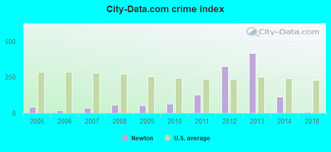
Crime rate in Newton detailed stats: murders, rapes, robberies, assaults, burglaries, thefts, arson
Full-time law enforcement employees in 2021, including police officers: 1 (1 officers - 1 male; 0 female).
| Officers per 1,000 residents here: | 1.82 |
| Georgia average: | 2.45 |
 Recent articles from our blog. Our writers, many of them Ph.D. graduates or candidates, create easy-to-read articles on a wide variety of topics.

 | Former Blackhall studios owner purchases 1,500 acres in Newton County to build a studio for his new streaming service (0 replies) |
| Facebook Newton County Expansion (1 reply) |
| Blue Geogia (219 replies) |
| Is migration to exurbs real (120 replies) |
| Atlanta suburb relocation advice (274 replies) |
| As of 2021, what are your opinions on the 2nd and 3rd tier GA cities? (69 replies) |
Latest news from Newton, GA collected exclusively by city-data.com from local newspapers, TV, and radio stations
Ancestries: English (6.9%), German (5.5%), American (4.8%), African (1.7%).
Current Local Time: EST time zone
Elevation: 150 feet
Land area: 2.91 square miles.
Population density: 199 people per square mile (very low).
2 residents are foreign born
| This city: | 0.4% |
| Georgia: | 10.4% |
| Newton city: | 1.5% ($503) |
| Georgia: | 0.9% ($919) |
Nearest city with pop. 50,000+: West Dougherty, GA (19.9 miles  , pop. 59,680).
Nearest city with pop. 200,000+: Montgomery, AL (134.9 miles , pop. 201,568).
Nearest city with pop. 1,000,000+: Houston, TX (666.3 miles , pop. 1,953,631).
Nearest cities:
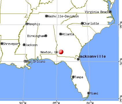
), ), )Latitude: 31.32 N, Longitude: 84.34 W
Area code: 229
| Here: | 3.9% |
| Georgia: | 2.9% |
- Health care (14.1%)
- Public administration (12.6%)
- Agriculture, forestry, fishing & hunting (8.6%)
- Educational services (6.3%)
- Gasoline stations (5.9%)
- Food (5.6%)
- Food & beverage stores (3.7%)
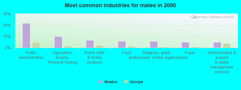
- Public administration (21.7%)
- Agriculture, forestry, fishing & hunting (10.0%)
- Textile mills & textile products (6.7%)
- Food (5.8%)
- Religious, grantmaking, civic, professional, similar organizations (5.8%)
- Paper (5.0%)
- Administrative & support & waste management services (5.0%)
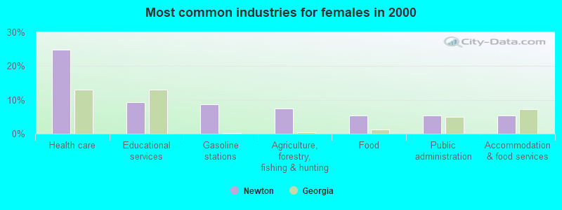
- Health care (24.8%)
- Educational services (9.4%)
- Gasoline stations (8.7%)
- Agriculture, forestry, fishing & hunting (7.4%)
- Food (5.4%)
- Public administration (5.4%)
- Accommodation & food services (5.4%)
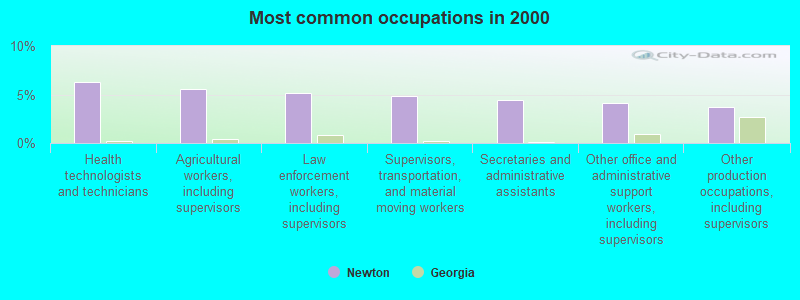
- Health technologists and technicians (6.3%)
- Agricultural workers, including supervisors (5.6%)
- Law enforcement workers, including supervisors (5.2%)
- Supervisors, transportation, and material moving workers (4.8%)
- Secretaries and administrative assistants (4.5%)
- Other office and administrative support workers, including supervisors (4.1%)
- Other production occupations, including supervisors (3.7%)
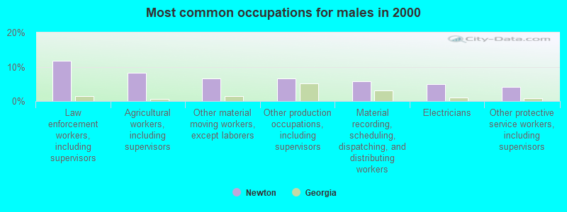
- Law enforcement workers, including supervisors (11.7%)
- Agricultural workers, including supervisors (8.3%)
- Other material moving workers, except laborers (6.7%)
- Other production occupations, including supervisors (6.7%)
- Material recording, scheduling, dispatching, and distributing workers (5.8%)
- Electricians (5.0%)
- Other protective service workers, including supervisors (4.2%)
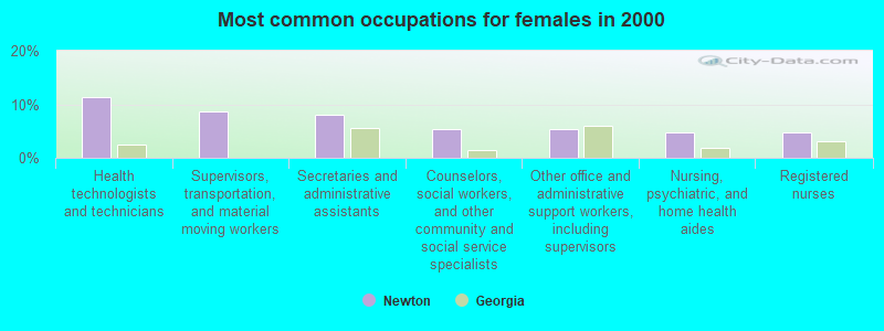
- Health technologists and technicians (11.4%)
- Supervisors, transportation, and material moving workers (8.7%)
- Secretaries and administrative assistants (8.1%)
- Counselors, social workers, and other community and social service specialists (5.4%)
- Other office and administrative support workers, including supervisors (5.4%)
- Nursing, psychiatric, and home health aides (4.7%)
- Registered nurses (4.7%)
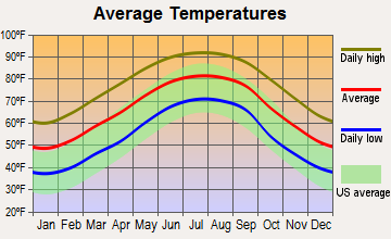
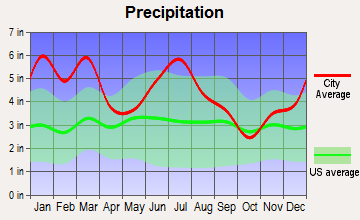
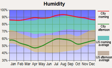
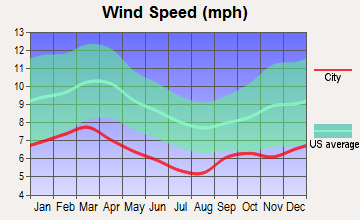
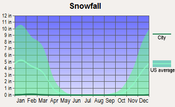
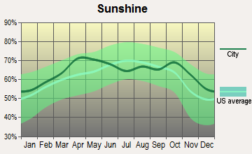
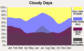
Average climate in Newton, Georgia
Based on data reported by over 4,000 weather stations
(lower is better)
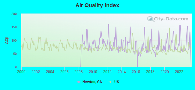
Air Quality Index (AQI) level in 2023 was 101. This is worse than average.
| City: | 101 |
| U.S.: | 73 |
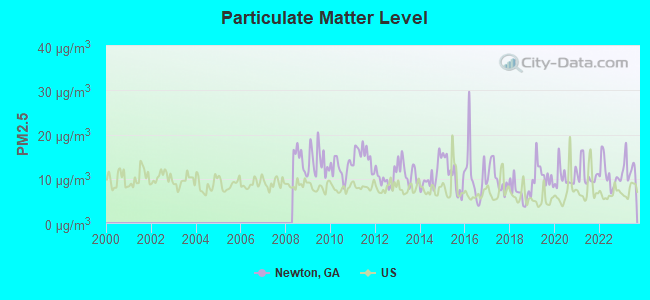
Particulate Matter (PM2.5) [µg/m3] level in 2023 was 12.4. This is significantly worse than average. Closest monitor was 22.9 miles away from the city center.
| City: | 12.4 |
| U.S.: | 8.1 |
Tornado activity:
Newton-area historical tornado activity is slightly above Georgia state average. It is 46% greater than the overall U.S. average.
On 3/20/2003, a category F3 (max. wind speeds 158-206 mph) tornado 10.3 miles away from the Newton city center killed 6 people and injured 200 people and caused $7 million in damages.
On 2/13/2000, a category F3 tornado 11.0 miles away from the city center killed 11 people and injured 175 people and caused $20 million in damages.
Earthquake activity:
Newton-area historical earthquake activity is significantly above Georgia state average. It is 12% smaller than the overall U.S. average.On 10/24/1997 at 08:35:17, a magnitude 4.9 (4.8 MB, 4.2 MS, 4.9 LG, Depth: 6.2 mi, Class: Light, Intensity: IV - V) earthquake occurred 174.0 miles away from Newton center
On 8/2/1974 at 08:52:09, a magnitude 4.9 (4.3 MB, 4.9 LG) earthquake occurred 207.1 miles away from the city center
On 4/29/2003 at 08:59:39, a magnitude 4.9 (4.4 MB, 4.6 MW, 4.9 LG) earthquake occurred 232.2 miles away from the city center
On 1/18/1999 at 07:00:53, a magnitude 4.8 (4.8 MB, 4.0 LG, Depth: 0.6 mi) earthquake occurred 223.3 miles away from the city center
On 4/29/2003 at 08:59:39, a magnitude 4.6 (4.6 MW, Depth: 12.3 mi) earthquake occurred 232.2 miles away from Newton center
On 11/22/1974 at 05:25:55, a magnitude 4.7 (4.7 MB) earthquake occurred 269.0 miles away from Newton center
Magnitude types: regional Lg-wave magnitude (LG), body-wave magnitude (MB), surface-wave magnitude (MS), moment magnitude (MW)
Natural disasters:
The number of natural disasters in Baker County (13) is near the US average (15).Major Disasters (Presidential) Declared: 9
Emergencies Declared: 2
Causes of natural disasters: Floods: 6, Storms: 6, Tornadoes: 6, Hurricanes: 2, Tropical Storms: 2, Winds: 2, Drought: 1, Heavy Rain: 1, Other: 1 (Note: some incidents may be assigned to more than one category).
Colleges/universities with over 2000 students nearest to Newton:
- Albany Technical College (about 20 miles; Albany, GA; Full-time enrollment: 3,707)
- Darton State College (about 20 miles; Albany, GA; FT enrollment: 5,000)
- Albany State University (about 22 miles; Albany, GA; FT enrollment: 3,662)
- Bainbridge State College (about 32 miles; Bainbridge, GA; FT enrollment: 2,308)
- Abraham Baldwin Agricultural College (about 50 miles; Tifton, GA; FT enrollment: 2,564)
- Georgia Southwestern State University (about 52 miles; Americus, GA; FT enrollment: 2,689)
- Tallahassee Community College (about 61 miles; Tallahassee, FL; FT enrollment: 10,904)
Public high school in Newton:
- BAKER COUNTY K12 SCHOOL (Students: 422, Location: 260 GA HIGHWAY 37 SW, Grades: PK-12)
Points of interest:
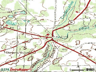
Notable locations in Newton: Newton Volunteer Fire Department (A), Baker County Courthouse (B). Display/hide their locations on the map
Creek: Cooleewahee Creek (A). Display/hide its location on the map
Courts: Baker Co Superion Court Clerks (167 Baker Place), Baker County - Clerk's Superior Court Ofc (Main Street), Baker County - Magistrate Court (Main Street).
Birthplace of: Bob Trice - Baseball player.
| This city: | 2.5 people |
| Georgia: | 2.6 people |
| This city: | 59.7% |
| Whole state: | 68.5% |
| This city: | 7.6% |
| Whole state: | 5.9% |
No gay or lesbian households reported
Banks with branches in Newton (2011 data):
- Southwest Georgia Bank: Baker County Branch at Highways 91 And 200, branch established on 1906/10/15. Info updated 2006/11/03: Bank assets: $305.0 mil, Deposits: $249.5 mil, headquarters in Moultrie, GA, positive income, Commercial Lending Specialization, 6 total offices, Holding Company: Southwest Georgia Financial Corporation
For population 15 years and over in Newton:
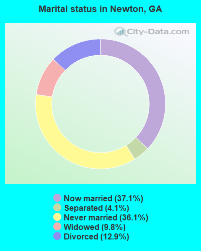
- Never married: 36.1%
- Now married: 37.1%
- Separated: 4.1%
- Widowed: 9.8%
- Divorced: 12.9%
For population 25 years and over in Newton:
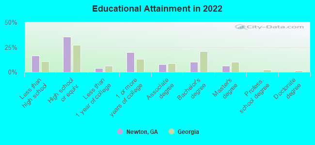
- High school or higher: 82.3%
- Bachelor's degree or higher: 15.7%
- Graduate or professional degree: 5.7%
- Unemployed: 14.3%
- Mean travel time to work (commute): 27.4 minutes
| Here: | 11.4 |
| Georgia average: | 12.2 |
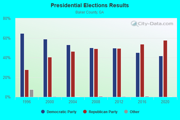
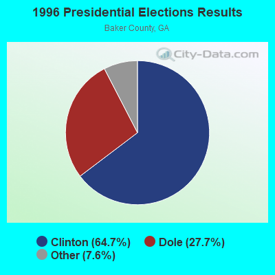
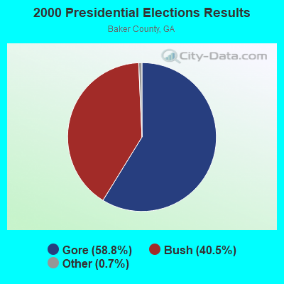
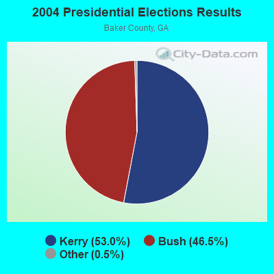
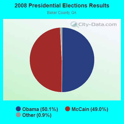
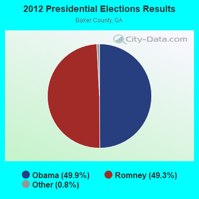
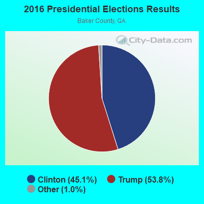

Graphs represent county-level data. Detailed 2008 Election Results
Religion statistics for Newton, GA (based on Baker County data)
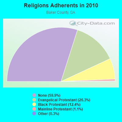
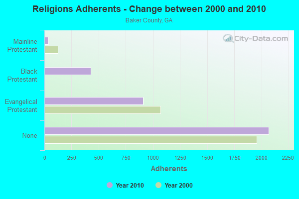
| Religion | Adherents | Congregations |
|---|---|---|
| Evangelical Protestant | 909 | 10 |
| Black Protestant | 427 | 3 |
| Mainline Protestant | 37 | 2 |
| Other | 10 | - |
| Catholic | - | - |
| None | 2,068 | - |
Food Environment Statistics:
| Baker County: | 2.65 / 10,000 pop. |
| Georgia: | 1.91 / 10,000 pop. |
| Baker County: | 2.65 / 10,000 pop. |
| State: | 5.12 / 10,000 pop. |
| This county: | 5.30 / 10,000 pop. |
| State: | 7.41 / 10,000 pop. |
| Here: | 13.1% |
| Georgia: | 10.4% |
| Here: | 32.5% |
| State: | 27.8% |
| Here: | 13.4% |
| Georgia: | 14.6% |
Health and Nutrition:
| Newton: | 46.0% |
| Georgia: | 48.9% |
| Newton: | 41.3% |
| Georgia: | 46.5% |
| Newton: | 29.4 |
| State: | 28.9 |
| This city: | 21.8% |
| Georgia: | 20.4% |
| This city: | 12.5% |
| State: | 10.8% |
| Newton: | 6.7 |
| State: | 6.7 |
| This city: | 34.2% |
| Georgia: | 33.5% |
| Here: | 51.0% |
| Georgia: | 56.2% |
| Newton: | 79.5% |
| Georgia: | 80.8% |
More about Health and Nutrition of Newton, GA Residents
| Local government employment and payroll (March 2022) | |||||
| Function | Full-time employees | Monthly full-time payroll | Average yearly full-time wage | Part-time employees | Monthly part-time payroll |
|---|---|---|---|---|---|
| Financial Administration | 3 | $6,800 | $27,200 | 4 | $2,693 |
| Judicial and Legal | 0 | $0 | 3 | $2,622 | |
| Other Government Administration | 0 | $0 | 5 | $300 | |
| Totals for Government | 3 | $6,800 | $27,200 | 12 | $5,615 |
Newton government finances - Expenditure in 2017 (per resident):
- Current Operations - Police Protection: $188,000 ($324.70)
Central Staff Services: $82,000 ($141.62)
Solid Waste Management: $61,000 ($105.35)
Regular Highways: $60,000 ($103.63)
Water Utilities: $32,000 ($55.27)
Sewerage: $25,000 ($43.18)
General - Other: $18,000 ($31.09)
Local Fire Protection: $9,000 ($15.54)
Health - Other: $6,000 ($10.36)
Judicial and Legal Services: $5,000 ($8.64)
General Public Buildings: $4,000 ($6.91)
- Other Capital Outlay - Police Protection: $25,000 ($43.18)
Regular Highways: $4,000 ($6.91)
- Total Salaries and Wages: $149,000 ($257.34)
Newton government finances - Revenue in 2017 (per resident):
- Charges - Solid Waste Management: $94,000 ($162.35)
Sewerage: $32,000 ($55.27)
- Federal Intergovernmental - General Local Government Support: $21,000 ($36.27)
- Local Intergovernmental - Other: $56,000 ($96.72)
General Local Government Support: $26,000 ($44.91)
- Miscellaneous - Fines and Forfeits: $60,000 ($103.63)
General Revenue - Other: $3,000 ($5.18)
Sale of Property: $1,000 ($1.73)
- Revenue - Water Utilities: $31,000 ($53.54)
- Tax - Property: $88,000 ($151.99)
Alcoholic Beverage Sales: $37,000 ($63.90)
Occupation and Business License - Other: $15,000 ($25.91)
Public Utilities Sales: $5,000 ($8.64)
Newton government finances - Cash and Securities in 2017 (per resident):
- Other Funds - Cash and Securities: $106,000 ($183.07)
Strongest AM radio stations in Newton:
- WSTT (730 AM; 25 kW; THOMASVILLE, GA; Owner: MARION R. WILLIAMS)
- WJYZ (960 AM; 5 kW; ALBANY, GA; Owner: CLEAR CHANNEL BROADCASTING LICENSES, INC.)
- WJEP (1020 AM; daytime; 10 kW; OCHLOCKNEE, GA; Owner: LIFELINE MINISTRIES, INCORPORATED)
- WMGA (1130 AM; 10 kW; MOULTRIE, GA; Owner: RADIO MOULTRIE, INC.)
- WHGH (840 AM; daytime; 10 kW; THOMASVILLE, GA; Owner: H. G. H INVESTMENT CORP.)
- WALG (1590 AM; 5 kW; ALBANY, GA; Owner: CUMULUS LICENSING CORP.)
- WMGR (930 AM; 5 kW; BAINBRIDGE, GA; Owner: DECATUR BROADCASTING, INC.)
- WMAC (940 AM; 50 kW; MACON, GA; Owner: CUMULUS LICENSING CORP.)
- WFVR (910 AM; 50 kW; VALDOSTA, GA; Owner: RAMA COMMUNICATIONS, INC.)
- WMTM (1300 AM; 5 kW; MOULTRIE, GA; Owner: COLQUITT BROADCASTING COMPANY, LLC)
- WOKV (690 AM; 50 kW; JACKSONVILLE, FL; Owner: COX RADIO, INC.)
- WGST (640 AM; 50 kW; ATLANTA, GA; Owner: CITICASTERS LICENSES, L.P.)
- WFRF (1070 AM; daytime; 10 kW; TALLAHASSEE, FL; Owner: FAITH RADIO NETWORK, INC.)
Strongest FM radio stations in Newton:
- WRAK-FM (97.3 FM; BAINBRIDGE, GA; Owner: CLEAR CHANNEL BROADCASTING LICENSES, INC.)
- WKAK (104.5 FM; ALBANY, GA; Owner: CUMULUS LICENSING CORP.)
- WQVE (105.5 FM; CAMILLA, GA; Owner: CUMULUS LICENSING CORP.)
- WOBB (100.3 FM; TIFTON, GA; Owner: CLEAR CHANNEL BROADCASTING LICENSES, INC.)
- WKVH (91.9 FM; MONTICELLO, FL; Owner: EDUCATIONAL MEDIA FOUNDATION)
- WJAD (103.5 FM; LEESBURG, GA; Owner: CUMULUS LICENSING CORP.)
- WJIZ-FM (96.3 FM; ALBANY, GA; Owner: CLEAR CHANNEL BROADCASTING LICENSES, INC.)
- WWXC (90.7 FM; ALBANY, GA; Owner: LAMAD MINISTRIES, INC.)
- WEGC (107.7 FM; SASSER, GA; Owner: CUMULUS LICENSING CORP.)
- W273AE (102.5 FM; ALBANY, GA; Owner: BIBLE BROADCASTING NETWORK, INC.)
- WNUQ (101.7 FM; ALBANY, GA; Owner: CUMULUS LICENSING CORP.)
TV broadcast stations around Newton:
- WABW-TV (Channel 14; PELHAM, GA; Owner: GEORGIA PUBLIC TELECOMMUNICATIONS COMMISSION)
- WTLH (Channel 49; BAINBRIDGE, GA; Owner: WTLH LICENSE CORP.)
- WALB (Channel 10; ALBANY, GA; Owner: LIBCO, INC.)
- WTWC-TV (Channel 40; TALLAHASSEE, FL; Owner: WTWC LICENSEE, LLC)
- W19CP (Channel 19; MOULTRIE, GA; Owner: TIFT AREA TV)
- WFXL (Channel 31; ALBANY, GA; Owner: WAITT LICENSE COMPANY OF GEORGIA, L.L.C.)
- WCTV (Channel 6; THOMASVILLE, GA; Owner: WCTV LICENSEE CORP.)
- W02CE (Channel 2; CAMILLA, GA; Owner: MITCHELL COUNTY TELEVISION)
- WTXL-TV (Channel 27; TALLAHASSEE, FL; Owner: MEDIA VENTURE MANAGEMENT, INC.)
- W34CZ (Channel 34; ALBANY, GA; Owner: TRINITY BROADCASTING NETWORK)
- W08DM (Channel 8; COLQUITT, GA; Owner: MS COMMUNICATIONS, LLC)
- W69DO (Channel 69; COLQUITT, GA; Owner: MS COMMUNICATIONS, LLC)
- WACS-TV (Channel 25; DAWSON, GA; Owner: GEORGIA PUBLIC TELECOMMUNICATIONS COMMISSION)
- W26BM (Channel 26; COLQUITT, GA; Owner: MS COMMUNICATIONS, LLC)
- WBKL-LP (Channel 35; ALBANY, GA; Owner: GWENDOLYN BOONE)
- W45BL (Channel 45; COLQUITT, GA; Owner: MS COMMUNICATIONS, LLC)
- W51CQ (Channel 51; COLQUITT, GA; Owner: MS COMMUNICATIONS, LLC)
- Newton, Georgia
- Fatal accident count18
- Vehicles involved in fatal accidents27
- Fatal accidents involving drunk persons:5
- Fatalities20
- Persons involved in fatal accidents41
- Pedestrians involved in fatal accidents0
- Georgia average
- Fatal accident count21553
- Vehicles involved in fatal accidents32302
- Fatal accidents involving drunk persons6850
- Fatalities24181
- Persons involved in fatal accidents54576
- Pedestrians involved in fatal accidents1371
- National Bridge Inventory (NBI) Statistics
- 2Number of bridges
- 144ft / 43.7mTotal length
- $8,404,000Total costs
- 6,420Total average daily traffic
- 537Total average daily truck traffic
- 9,630Total future (year 2031) average daily traffic
FCC Registered Cell Phone Towers:
1 (See the full list of FCC Registered Cell Phone Towers in Newton)FCC Registered Antenna Towers:
68 (See the full list of FCC Registered Antenna Towers)FCC Registered Broadcast Land Mobile Towers:
5- 6.5 Mi Ne On Hwy 91 (Lat: 31.356278 Lon: -84.266861), Type: Tower, Structure height: 50 m, Call Sign: WNUX996,
Assigned Frequencies: 458.562 MHz, Grant Date: 12/17/2015, Expiration Date: 11/30/2025, Registrant: Albany Communications, Inc., Albany, GA 31708, Phone: (229) 432-9301, Fax: (229) 436-3189, Email:
- Ga 216 11 Mi Nw (Lat: 31.355722 Lon: -84.503528), Call Sign: KIB218, Licensee ID: L00011952,
Assigned Frequencies: 151.280 MHz, 159.360 MHz, 159.390 MHz, Grant Date: 09/22/1998, Expiration Date: 10/03/2003, Cancellation Date: 08/23/2002, Registrant: State Of Georgia, 200 Piedmont Ave1402 West, Atlanta, GA 30334-9010, Phone: (404) 656-2042
- 6 1/2 Mi Ne On Hwy 91 (Lat: 31.356278 Lon: -84.266861), Call Sign: KNHQ230,
Assigned Frequencies: 451.725 MHz, 451.725 MHz, Grant Date: 10/14/2023, Expiration Date: 10/19/2033, Registrant: Mobile Communications Of America, 3303 Gillionville Road, Albany, GA 31721, Phone: (229) 432-9301, Fax: (229) 436-3189, Email:
- Approx 9 Mi W On Old Dam Rd (Lat: 31.299611 Lon: -84.492417), Call Sign: WYL768, Licensee ID: L00418117,
Assigned Frequencies: 152.990 MHz, Grant Date: 04/13/1999, Expiration Date: 04/14/2004, Cancellation Date: 06/19/2004, Registrant: Burch Farms, Rt 1 Box 1785, Newton, GA 31770
- Lat: 31.306278 Lon: -84.405556, Call Sign: WRJN710,
Assigned Frequencies: 452.762 MHz, 457.762 MHz, Grant Date: 09/30/2020, Expiration Date: 09/30/2030, Certifier: Allen Thridge, Registrant: Mobile Communications Of America, 3303 Gillionville Road, Albany, GA 31721, Phone: (229) 432-9301, Email:
FCC Registered Microwave Towers:
1- NEWTON (GA), Off Newton Highway (Lat: 31.303444 Lon: -84.344222), Type: Gtower, Structure height: 121.9 m, Overall height: 128 m, Call Sign: WRMW565,
Assigned Frequencies: 11465.0 MHz, 11505.0 MHz, 11465.0 MHz, 11505.0 MHz, 11465.0 MHz, 11505.0 MHz, 11465.0 MHz, 11505.0 MHz, 11465.0 MHz, 11505.0 MHz... (+6 more), Grant Date: 06/15/2021, Expiration Date: 06/15/2031, Certifier: Larry F Butts, Registrant: Southern Company Services, 600 N. 18th St / Bin 5n-5409, Birmingham, AL 35203, Phone: (205) 257-7600, Fax: (205) 257-2134, Email:
FCC Registered Amateur Radio Licenses:
3- Call Sign: KD4MFN, Licensee ID: L00442770, Grant Date: 01/06/2012, Expiration Date: 03/31/2022, Certifier: Robert L Andrews, Registrant: Robert L Andrews, Newton, GA 31770
- Call Sign: KJ4KE, Grant Date: 07/05/1995, Expiration Date: 07/05/2005, Cancellation Date: 07/06/2007, Registrant: Ernest A Iler Jr, Rt 1 Box 2051, Newton, GA 31770-9801
- Call Sign: KF5NKY, Licensee ID: L01673245, Grant Date: 10/28/2021, Expiration Date: 11/17/2031, Certifier: Andrew C Parker, Registrant: Andrew C Parker, 919 Pretoria Rd, Newton, GA 39870
FAA Registered Aircraft:
4- Aircraft: CHAMPION 7EC (Category: Land, Seats: 2, Weight: Up to 12,499 Pounds, Speed: 90 mph), Engine: CONT MOTOR C90-12F (95 HP) (Reciprocating)
N-Number: 8969R, N8969R, N-8969R, Serial Number: 7EC-728, Year manufactured: 1960, Airworthiness Date: 03/21/2008, Certificate Issue Date: 09/14/2019
Registrant (Individual): Richard B Etchells, 2221 John C Durham Rd, Newton, GA 39870 - Aircraft: CESSNA 150M (Category: Land, Seats: 2, Weight: Up to 12,499 Pounds, Speed: 81 mph), Engine: CONT MOTOR 0-200 SERIES (100 HP) (4 Cycle)
N-Number: 9460U, N9460U, N-9460U, Serial Number: 15078408, Year manufactured: 1976, Airworthiness Date: 05/26/1989, Certificate Issue Date: 04/04/2006
Registrant (Individual): Richard B Etchells, 2221 John C Durham Rd, Newton, GA 39870 - Aircraft: CESSNA A188B (Category: Land, Weight: Up to 12,499 Pounds, Speed: 108 mph), Engine: CONT MOTOR IO 520 SERIES (285 HP) (Reciprocating)
N-Number: 4845R, N4845R, N-4845R, Serial Number: 18802364T, Year manufactured: 1975, Airworthiness Date: 10/10/1975, Certificate Issue Date: 09/06/2011
Registrant (Individual): Charles Wesley Allen, 3383 Travelers Rest Rd, Newton, GA 39870
Deregistered: Cancel Date: 04/18/2018 - Aircraft: CESSNA A188B (Category: Land, Weight: Up to 12,499 Pounds, Speed: 108 mph), Engine: CONT MOTOR IO-520-D (300 HP) (Reciprocating)
N-Number: 1097R, N1097R, N-1097R, Serial Number: 18802129T, Year manufactured: 1975, Airworthiness Date: 06/26/2008, Certificate Issue Date: 09/18/2001
Registrant (Individual): Charles W Dba Allen, Po Box 402, Newton, GA 31770, Other Owners: Flying Service Allen
Deregistered: Cancel Date: 07/17/2017
2004 - 2018 National Fire Incident Reporting System (NFIRS) incidents
- Fire incident types reported to NFIRS in Newton, GA
- 6243.1%Outside Fires
- 4329.9%Structure Fires
- 3927.1%Mobile Property/Vehicle Fires
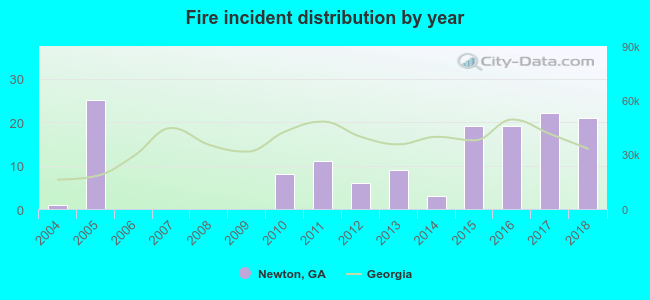 Based on the data from the years 2004 - 2018 the average number of fire incidents per year is 10. The highest number of reported fire incidents - 25 took place in 2005, and the least - 0 in 2006. The data has an increasing trend.
 When looking into fire subcategories, the most incidents belonged to: Outside Fires (43.1%), and Structure Fires (29.9%).
| Most common first names in Newton, GA among deceased individuals | ||
| Name | Count | Lived (average) |
|---|---|---|
| James | 16 | 75.3 years |
| Willie | 14 | 65.4 years |
| John | 14 | 70.3 years |
| William | 13 | 74.2 years |
| Charlie | 11 | 74.4 years |
| Thomas | 10 | 66.0 years |
| Annie | 10 | 78.9 years |
| Henry | 9 | 73.6 years |
| Robert | 8 | 62.6 years |
| Mary | 8 | 87.5 years |
| Most common last names in Newton, GA among deceased individuals | ||
| Last name | Count | Lived (average) |
|---|---|---|
| Hawkins | 22 | 73.0 years |
| Edwards | 15 | 73.5 years |
| Hall | 12 | 72.5 years |
| Williams | 12 | 62.2 years |
| Davis | 9 | 77.0 years |
| Collins | 9 | 75.4 years |
| Butler | 9 | 66.5 years |
| Jones | 9 | 78.8 years |
| Parker | 8 | 71.0 years |
| Irvin | 8 | 78.0 years |
Newton compared to Georgia state average:
- Median household income significantly below state average.
- Median house value significantly below state average.
- Hispanic race population percentage significantly below state average.
- Median age below state average.
- Foreign-born population percentage significantly below state average.
- Length of stay since moving in significantly above state average.
- Number of rooms per house below state average.
- Number of college students below state average.