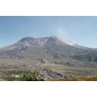
Patterson, Idaho
Submit your own pictures of this place and show them to the world
- OSM Map
- General Map
- Google Map
- MSN Map

| Males: 260 | |
| Females: 235 |
| Median resident age: | 52.0 years |
| Idaho median age: | 33.2 years |
Zip code: 83467
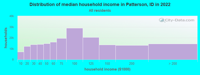
| Patterson: | $33,381 |
| ID: | $72,785 |
Estimated per capita income in 2022: $26,382 (it was $12,655 in 2000)
Patterson CCD income, earnings, and wages data
Estimated median house or condo value in 2022: $298,479 (it was $82,000 in 2000)
| Patterson: | $298,479 |
| ID: | $432,500 |
Mean prices in 2022: all housing units: $407,354; detached houses: $436,876; townhouses or other attached units: $342,524; mobile homes: $221,567
Detailed information about poverty and poor residents in Patterson, ID
Compare current foreclosures near your location:
| Photo | Address | Area | Beds / Baths | Price | Details |
|---|---|---|---|---|---|

|
#1
E 21st Ave
Columbus, OH 43211
|
1,061 sq. feet
|
1 baths 3 beds |
$179,900
|
show details |

|
#2
S High St
Columbus, OH 43207
|
1,678 sq. feet
|
2 baths 4 beds |
$31,900
|
show details |

|
#3
Bayberry Cir
Columbus, OH 43207
|
1,564 sq. feet
|
1 baths 3 beds |
$127,500
|
show details |

|
#4
Armada Rd
Columbus, OH 43232
|
1,028 sq. feet
|
1 baths 4 beds |
show details | |

|
#5
Grasmere Ave
Columbus, OH 43211
|
720 sq. feet
|
1 baths 2 beds |
show details | |

|
#6
Safford Ave
Columbus, OH 43223
|
784 sq. feet
|
1 baths 2 beds |
show details | |

|
#7
Scottwood Rd
Columbus, OH 43227
|
1,008 sq. feet
|
1 baths 3 beds |
show details | |

|
#8
Summertree Ln
Westerville, OH 43081
|
2,496 sq. feet
|
2 baths 3 beds |
show details | |

|
#9
Derrer Rd -872
Columbus, OH 43204
|
1,667 sq. feet
|
2 baths 5 beds |
show details | |

|
#10
Wrexham Ave
Columbus, OH 43223
|
1,235 sq. feet
|
1 baths 3 beds |
show details |
| Photo | Address | Area | Beds / Baths | Price | Details |
|---|---|---|---|---|---|

|
#11
Lehner Rd
Columbus, OH 43224
|
1,628 sq. feet
|
2 baths 4 beds |
show details | |

|
#12
Fahlander Dr N
Columbus, OH 43229
|
1,338 sq. feet
|
2 baths 3 beds |
show details | |

|
#13
High Free Pike
West Jefferson, OH 43162
|
1,216 sq. feet
|
2 baths 4 beds |
show details | |

|
#14
S Richardson Ave
Columbus, OH 43204
|
1,520 sq. feet
|
2 baths 3 beds |
show details | |

|
#15
Brookstone Dr
Westerville, OH 43082
|
1,783 sq. feet
|
3 baths 3 beds |
show details | |

|
#16
E Howard Rd
Columbus, OH 43207
|
1,056 sq. feet
|
1 baths 3 beds |
show details | |

|
#17
Midland Ave
Columbus, OH 43223
|
1,518 sq. feet
|
1 baths 2 beds |
show details | |

|
#18
Marshrun Dr
Grove City, OH 43123
|
2,036 sq. feet
|
2 baths 4 beds |
show details | |

|
#19
N Roys Ave
Columbus, OH 43204
|
1,248 sq. feet
|
2 baths 3 beds |
show details | |

|
#20
Meadowbrook Dr
Columbus, OH 43207
|
1,752 sq. feet
|
2 baths 4 beds |
show details |
| Photo | Address | Area | Beds / Baths | Price | Details |
|---|---|---|---|---|---|

|
#21
Stoneybrook Blvd # 21a
Hilliard, OH 43026
|
1,231 sq. feet
|
2 baths 3 beds |
show details | |

|
#22
Mink St SW
Pataskala, OH 43062
|
1,442 sq. feet
|
1 baths 3 beds |
show details | |

|
#23
London Groveport Rd
Grove City, OH 43123
|
816 sq. feet
|
1 baths 2 beds |
show details | |

|
#24
Glenmate Ct
Columbus, OH 43223
|
1,050 sq. feet
|
1 baths 3 beds |
show details | |

|
#25
Gladys Rd
Columbus, OH 43228
|
832 sq. feet
|
1 baths 3 beds |
show details | |

|
#26
Striebel Ct
Columbus, OH 43227
|
925 sq. feet
|
1 baths 3 beds |
show details | |

|
#27
N 18th St
Columbus, OH 43203
|
1,690 sq. feet
|
1 baths 4 beds |
show details | |

|
#28
Fergus Rd
Grove City, OH 43123
|
3,312 sq. feet
|
2 baths 4 beds |
show details | |

|
#29
Chester Rd
Columbus, OH 43221
|
3,300 sq. feet
|
4 baths 5 beds |
show details | |

|
#30
Sleeping Meadow Dr
New Albany, OH 43054
|
3,211 sq. feet
|
2 baths 4 beds |
show details |
| Photo | Address | Area | Beds / Baths | Price | Details |
|---|---|---|---|---|---|

|
#31
E Welch Ave
Columbus, OH 43207
|
1,864 sq. feet
|
2 baths 4 beds |
show details | |

|
#32
Kingsglen Dr
Grove City, OH 43123
|
1,635 sq. feet
|
2 baths 4 beds |
show details | |

|
#33
S Hague Ave
Columbus, OH 43204
|
979 sq. feet
|
1 baths 2 beds |
show details | |

|
#34
Ashgrove Dr
Grove City, OH 43123
|
1,772 sq. feet
|
2 baths 4 beds |
show details | |

|
#35
Chidley St
Galloway, OH 43119
|
1,502 sq. feet
|
1 baths 3 beds |
show details | |

|
#36
Hildreth Ave
Columbus, OH 43203
|
1,798 sq. feet
|
2 baths 4 beds |
show details | |

|
#37
Fairfield Ave
Columbus, OH 43203
|
984 sq. feet
|
1 baths 2 beds |
show details | |

|
#38
Ratify Blvd
Columbus, OH 43207
|
1,356 sq. feet
|
2 baths 3 beds |
show details | |

|
#39
Andrus Ave
Columbus, OH 43227
|
1,264 sq. feet
|
1 baths 3 beds |
show details | |

|
#40
Berrywood Dr
Columbus, OH 43220
|
1,182 sq. feet
|
1 baths 2 beds |
show details |
| Photo | Address | Area | Beds / Baths | Price | Details |
|---|---|---|---|---|---|

|
#41
Simpson Dr
Columbus, OH 43227
|
1,104 sq. feet
|
1 baths 3 beds |
show details | |

|
#42
Nantucket Ave
Columbus, OH 43235
|
1,864 sq. feet
|
2 baths 3 beds |
show details | |

|
#43
Bostwick Rd
Columbus, OH 43227
|
1,284 sq. feet
|
1 baths 4 beds |
show details | |

|
#44
Messner Dr
Hilliard, OH 43026
|
832 sq. feet
|
1 baths 2 beds |
show details | |

|
#45
Camhurst Ct
Galloway, OH 43119
|
1,969 sq. feet
|
2 baths 3 beds |
show details | |

|
#46
Illinois Ave
Westerville, OH 43081
|
1,120 sq. feet
|
1 baths 3 beds |
show details | |

|
#47
Renford Ct
Powell, OH 43065
|
1,795 sq. feet
|
1 baths 3 beds |
show details | |

|
#48
Casa Blvd
Grove City, OH 43123
|
1,002 sq. feet
|
1 baths 2 beds |
show details | |

|
#49
Mango Ln
Hilliard, OH 43026
|
1,024 sq. feet
|
1 baths 2 beds |
show details | |

|
Check over 1 million property listings on Foreclosure.com!
|
browse all offers | |||

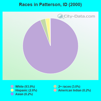
- 46393.9%White alone
- 153.0%Two or more races
- 132.6%Hispanic
- 10.2%American Indian alone
- 10.2%Asian alone
Races in Patterson detailed stats: ancestries, foreign born residents, place of birth
 Recent articles from our blog. Our writers, many of them Ph.D. graduates or candidates, create easy-to-read articles on a wide variety of topics.
Current Local Time: MST time zone
Elevation: 6000 feet
Land area: 620.3 square miles.
Population density: 0.8 people per square mile (very low).

| Patterson CCD: | 0.7% ($541) |
| Idaho: | 1.0% ($1,007) |
Nearest city with pop. 50,000+: Idaho Falls, ID  (130.8 miles , pop. 50,730).
Nearest city with pop. 200,000+: Northwest Clackamas, OR (425.6 miles , pop. 224,220).
Nearest city with pop. 1,000,000+: Los Angeles, CA (777.5 miles , pop. 3,694,820).
Nearest cities:
), ), )Latitude: 44.80 N, Longitude: 113.94 W
Area code commonly used in this area: 208

| Here: | 4.4% |
| Idaho: | 3.1% |
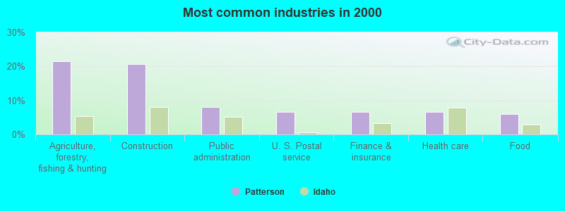
- Agriculture, forestry, fishing & hunting (21.5%)
- Construction (20.7%)
- Public administration (8.1%)
- U. S. Postal service (6.7%)
- Finance & insurance (6.7%)
- Health care (6.7%)
- Food (5.9%)
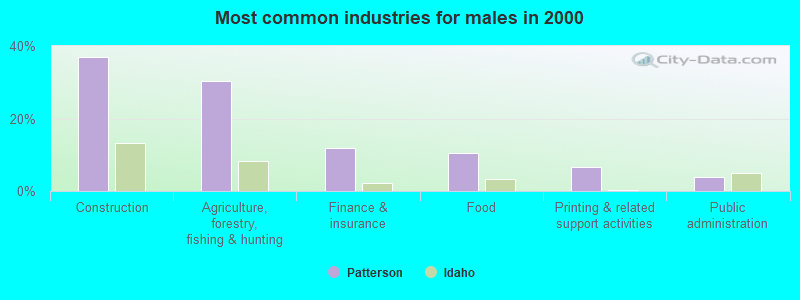
- Construction (36.8%)
- Agriculture, forestry, fishing & hunting (30.3%)
- Finance & insurance (11.8%)
- Food (10.5%)
- Printing & related support activities (6.6%)
- Public administration (3.9%)
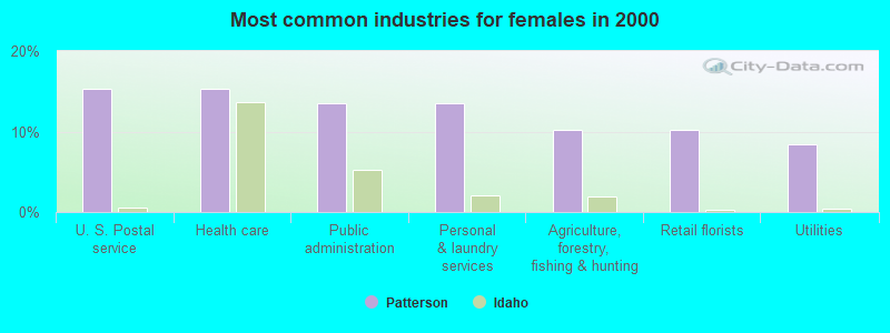
- U. S. Postal service (15.3%)
- Health care (15.3%)
- Public administration (13.6%)
- Personal & laundry services (13.6%)
- Agriculture, forestry, fishing & hunting (10.2%)
- Retail florists (10.2%)
- Utilities (8.5%)
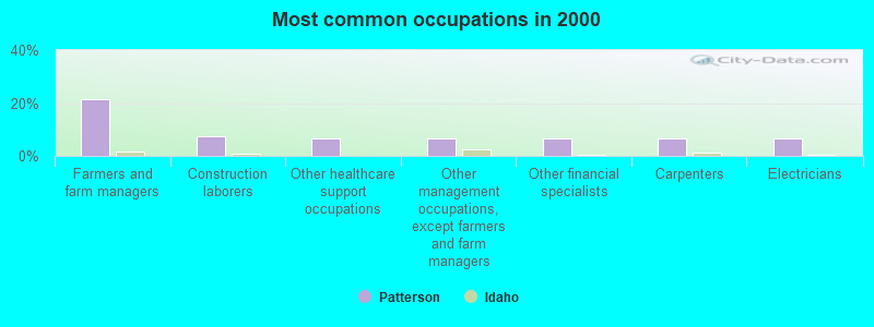
- Farmers and farm managers (21.5%)
- Construction laborers (7.4%)
- Other healthcare support occupations (6.7%)
- Other management occupations, except farmers and farm managers (6.7%)
- Other financial specialists (6.7%)
- Carpenters (6.7%)
- Electricians (6.7%)
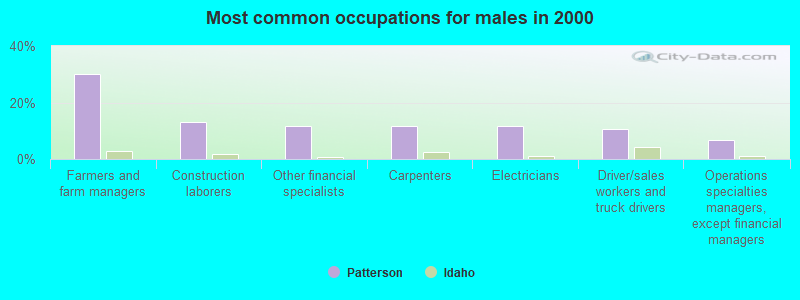
- Farmers and farm managers (30.3%)
- Construction laborers (13.2%)
- Other financial specialists (11.8%)
- Carpenters (11.8%)
- Electricians (11.8%)
- Driver/sales workers and truck drivers (10.5%)
- Operations specialties managers, except financial managers (6.6%)
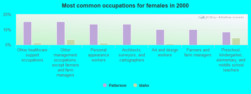
- Other healthcare support occupations (15.3%)
- Other management occupations, except farmers and farm managers (15.3%)
- Personal appearance workers (13.6%)
- Architects, surveyors, and cartographers (13.6%)
- Art and design workers (10.2%)
- Farmers and farm managers (10.2%)
- Preschool, kindergarten, elementary, and middle school teachers (8.5%)
Average climate in Patterson, Idaho
Based on data reported by over 4,000 weather stations


Earthquake activity:
Patterson-area historical earthquake activity is significantly above Idaho state average. It is 1135% greater than the overall U.S. average.On 10/28/1983 at 14:06:06, a magnitude 7.3 (6.2 MB, 7.3 MS, 7.0 MW, Class: Major, Intensity: VIII - XII) earthquake occurred 50.3 miles away from the city center, causing 2 deaths (2 shaking deaths) and 3 injuries, causing $15,000,000 total damage
On 8/18/1959 at 06:37:13, a magnitude 7.7 (7.7 UK) earthquake occurred 162.3 miles away from Patterson center, causing $26,000,000 total damage
On 3/31/2020 at 23:52:30, a magnitude 6.5 (6.5 MW, Depth: 7.5 mi, Class: Strong, Intensity: VII - IX) earthquake occurred 62.4 miles away from Patterson center
On 10/3/1915 at 06:52:48, a magnitude 7.6 (7.6 UK) earthquake occurred 348.0 miles away from the city center
On 8/22/1984 at 09:46:30, a magnitude 5.8 (5.0 MB, 5.1 MS, 5.8 ML, Class: Moderate, Intensity: VI - VII) earthquake occurred 21.4 miles away from the city center
On 10/29/1983 at 23:29:11, a magnitude 5.8 (5.4 MB, 5.0 MS, 5.8 ML) earthquake occurred 33.3 miles away from the city center
Magnitude types: body-wave magnitude (MB), local magnitude (ML), surface-wave magnitude (MS), moment magnitude (MW)
Natural disasters:
The number of natural disasters in Lemhi County (4) is a lot smaller than the US average (15).Major Disasters (Presidential) Declared: 2
Emergencies Declared: 1
Causes of natural disasters: Fire: 1, Flood: 1, Hurricane: 1, Other: 1 (Note: some incidents may be assigned to more than one category).
Colleges/universities with over 2000 students nearest to Patterson:
- Brigham Young University-Idaho (about 127 miles; Rexburg, ID; Full-time enrollment: 30,522)
- Boise State University (about 140 miles; Boise, ID; FT enrollment: 16,774)
- The University of Montana (about 143 miles; Missoula, MT; FT enrollment: 13,602)
- College of Western Idaho (about 152 miles; Nampa, ID; FT enrollment: 6,300)
- Montana State University (about 154 miles; Bozeman, MT; FT enrollment: 12,942)
- Idaho State University (about 154 miles; Pocatello, ID; FT enrollment: 10,350)
- College of Southern Idaho (about 156 miles; Twin Falls, ID; FT enrollment: 5,051)
Public elementary/middle school in Patterson:
- THREE CREEK ELEM-JR HI SCHOOL (Students: 4, Location: 49909 THREE CREEK RD, Grades: PK-8)
Points of interest:
Notable locations in Patterson: Lake Creek Ranch (A), Lime Creek Access Area (B), Deer Gulch Access Area (C), Camp Creek Access Area (D), Pahsimeroi Rearing Ponds (E), Pahsimeroi Hatchery (F), Big Creek Campground (G), Peterson Ranch (H), Williams Lake Recreation Site (I), Iron Lake Campground (J), Twin Peaks Ranch (K), Williams Creek Ranger Station (L), Cougar Point Recreation Site (M), Elk Bend Fire Protection District Station 1 (N), Pahsimeroi Volunteer Fire Department (O), Elk Bend Fire Protection District Station 4 (P), Elk Bend Fire Protection District Station 2 (Q). Display/hide their locations on the map
Lakes: Williams Lake (A), Goat Lake (B), Hat Creek Lakes (C). Display/hide their locations on the map
Streams, rivers, and creeks: Camp Creek (A), Cabin Creek (B), Buck Lake (C), Birch Creek (D), Park Creek (E), Park Fork (F), Peel Tree Creek (G), North Fork Williams Creek (H), Phantom Creek (I). Display/hide their locations on the map
| This place: | 1.9 people |
| Idaho: | 2.7 people |
| This place: | 57.9% |
| Whole state: | 69.6% |
| This place: | 5.9% |
| Whole state: | 6.3% |
No gay or lesbian households reported
| This place: | 23.6% |
| Whole state: | 11.8% |
| This place: | 5.6% |
| Whole state: | 4.6% |
For population 15 years and over in Patterson:
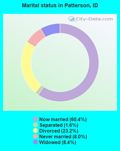
- Never married: 8.0%
- Now married: 60.4%
- Separated: 1.6%
- Widowed: 8.4%
- Divorced: 23.2%
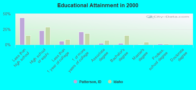
For population 25 years and over in Patterson:
- High school or higher: 56.2%
- Bachelor's degree or higher: 4.3%
- Graduate or professional degree: 2.0%
- Unemployed: 17.2%
- Mean travel time to work (commute): 20.7 minutes
| Here: | 12.6 |
| Idaho average: | 11.1 |
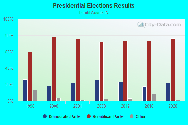

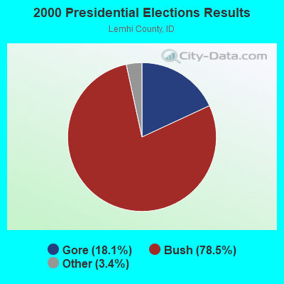


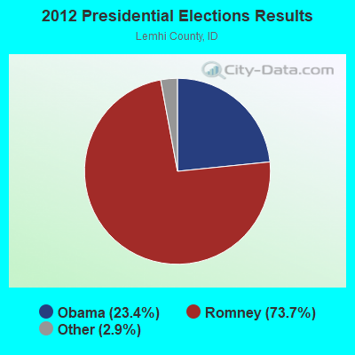
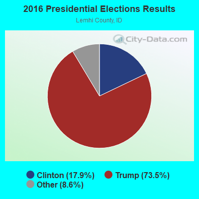
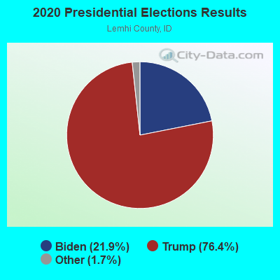
Graphs represent county-level data. Detailed 2008 Election Results
Religion statistics for Patterson, ID (based on Lemhi County data)
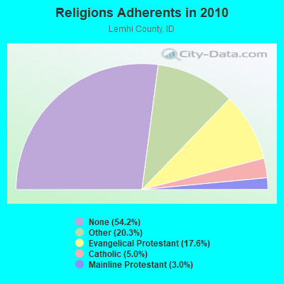
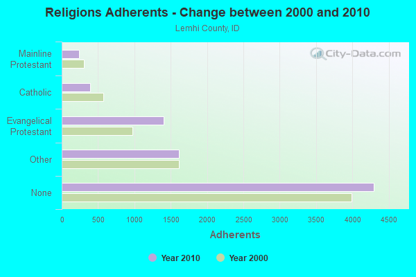
| Religion | Adherents | Congregations |
|---|---|---|
| Other | 1,609 | 5 |
| Evangelical Protestant | 1,398 | 12 |
| Catholic | 394 | 2 |
| Mainline Protestant | 237 | 4 |
| None | 4,298 | - |
Food Environment Statistics:
| This county: | 7.80 / 10,000 pop. |
| Idaho: | 1.88 / 10,000 pop. |
| Here: | 1.30 / 10,000 pop. |
| Idaho: | 0.53 / 10,000 pop. |
| Lemhi County: | 7.80 / 10,000 pop. |
| State: | 3.87 / 10,000 pop. |
| Lemhi County: | 13.00 / 10,000 pop. |
| Idaho: | 7.75 / 10,000 pop. |
| Here: | 7.8% |
| State: | 7.7% |
| This county: | 26.1% |
| State: | 25.7% |
| This county: | 7.6% |
| Idaho: | 11.7% |
Strongest AM radio stations in Patterson:
- KBOI (670 AM; 50 kW; BOISE, ID; Owner: CITADEL BROADCASTING COMPANY)
- KWEI (1260 AM; 50 kW; WEISER, ID; Owner: TREASURE VALLEY BROADCASTING CO.)
- KERR (750 AM; 50 kW; POLSON, MT; Owner: ANDERSON RADIO BROADCASTING, INC.)
- KSRA (960 AM; 1 kW; SALMON, ID; Owner: SALMON RIVER COMMUNICATIONS, INC.)
- KBSU (730 AM; 15 kW; BOISE, ID; Owner: IDAHO STATE BOARD OF EDUCATION)
- KALL (700 AM; 50 kW; NORTH SALT LAKE CITY, UT; Owner: CITICASTERS LICENSES, L.P.)
- KOFI (1180 AM; 50 kW; KALISPELL, MT; Owner: KOFI, INC.)
- KBOW (550 AM; 5 kW; BUTTE, MT; Owner: BUTTE BROADCASTING INCORPORATED)
- KZNR (690 AM; 10 kW; BLACKFOOT, ID; Owner: WESTERN COMMUNICATIONS, INC.)
- KGVW (640 AM; 10 kW; BELGRADE, MT; Owner: GALLATIN VALLEY WITNESS, INC.)
- KTBI (810 AM; daytime; 50 kW; EPHRATA, WA; Owner: TACOMA BROADCASTERS, INCORPORATED)
- KIQN (1010 AM; 50 kW; TOOELE, UT)
- KGA (1510 AM; 50 kW; SPOKANE, WA; Owner: CITADEL BROADCASTING COMPANY)
Strongest FM radio stations in Patterson:
- K204CC (88.7 FM; CHALLIS, ETC., ID; Owner: CHALLIS MISSION CHURCH)
TV broadcast stations around Patterson:
- K07SZ (Channel 7; ELK BEND, ID; Owner: ELK BEND TV, UNINC. ASSOC.)
- K12IP (Channel 12; ELK BEND, ID; Owner: ELK BEND T.V. UNINCORPORATED ASS)
FCC Registered Microwave Towers:
1- SUMMIT LAKE, Summit Lake Ridge 19 Mi Se Of (Lat: 44.306056 Lon: -113.484278), Type: Ltower, Structure height: 18.3 m, Overall height: 24.4 m, Call Sign: WBB781,
Assigned Frequencies: 6034.15 MHz, 6093.45 MHz, 6034.15 MHz, 6093.45 MHz, 6093.45 MHz, 6034.15 MHz, 6093.45 MHz, 6093.45 MHz, 6034.15 MHz, 6093.45 MHz... (+21 more), Grant Date: 08/02/2022, Expiration Date: 08/18/2032, Registrant: State Of Idaho, 700 South Stratford Drive, Building 6, Boise, ID 83720, Phone: (208) 288-4000, Fax: (208) 288-2605, Email:
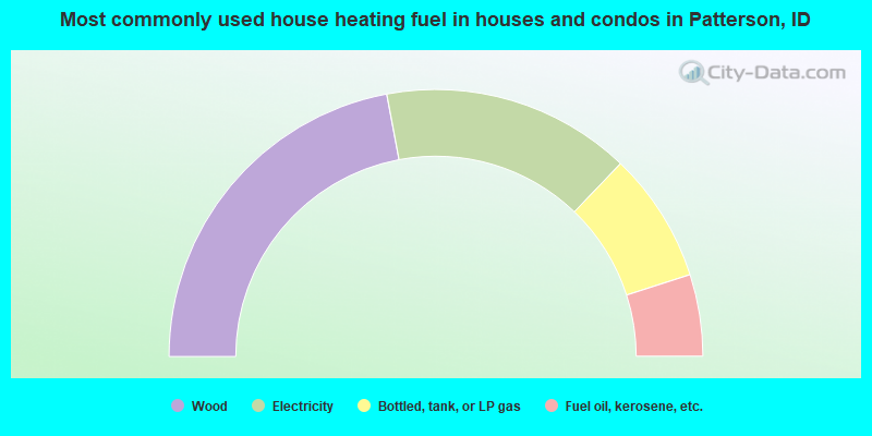
- 44.1%Wood
- 30.2%Electricity
- 15.8%Bottled, tank, or LP gas
- 9.9%Fuel oil, kerosene, etc.
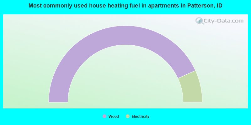
- 86.4%Wood
- 13.6%Electricity
Patterson compared to Idaho state average:
- Median household income below state average.
- Black race population percentage significantly below state average.
- Hispanic race population percentage significantly below state average.
- Median age significantly above state average.
- Foreign-born population percentage significantly below state average.
- Renting percentage below state average.
- Length of stay since moving in significantly above state average.
- Number of rooms per house significantly below state average.
- House age significantly below state average.
- Number of college students significantly below state average.
- Percentage of population with a bachelor's degree or higher significantly below state average.