Perryville, Kentucky
Submit your own pictures of this city and show them to the world
(4.3% for White Non-Hispanic residents, 47.2% for Black residents)
Detailed information about poverty and poor residents in Perryville, KY
Full-time law enforcement employees in 2010, including police officers: 1 (1 officers - 1 male; 0 female).
| Officers per 1,000 residents here: | 1.33 |
| Kentucky average: | 1.96 |
 Recent articles from our blog. Our writers, many of them Ph.D. graduates or candidates, create easy-to-read articles on a wide variety of topics.
| Here: | 4.1% |
| Kentucky: | 3.8% |
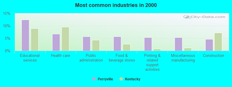
- Educational services (12.5%)
- Health care (6.8%)
- Public administration (5.7%)
- Food & beverage stores (5.7%)
- Printing & related support activities (5.3%)
- Miscellaneous manufacturing (5.3%)
- Construction (4.6%)
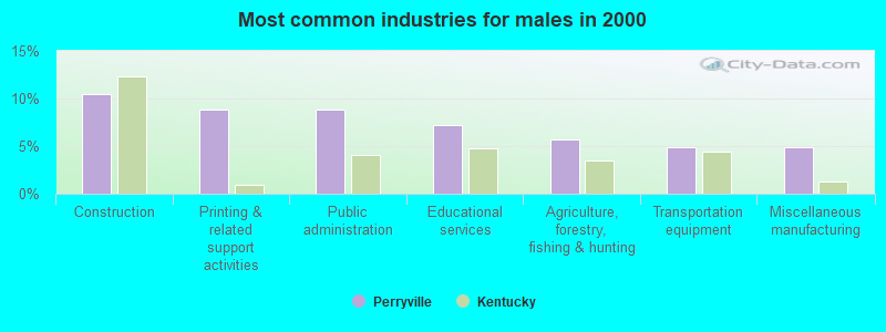
- Construction (10.5%)
- Printing & related support activities (8.9%)
- Public administration (8.9%)
- Educational services (7.3%)
- Agriculture, forestry, fishing & hunting (5.6%)
- Transportation equipment (4.8%)
- Miscellaneous manufacturing (4.8%)
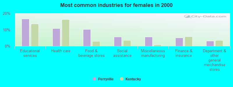
- Educational services (16.6%)
- Health care (10.8%)
- Food & beverage stores (10.2%)
- Social assistance (5.7%)
- Miscellaneous manufacturing (5.7%)
- Finance & insurance (5.1%)
- Department & other general merchandise stores (3.2%)
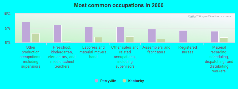
- Other production occupations, including supervisors (7.1%)
- Preschool, kindergarten, elementary, and middle school teachers (6.0%)
- Laborers and material movers, hand (5.3%)
- Other sales and related occupations, including supervisors (5.3%)
- Assemblers and fabricators (4.6%)
- Registered nurses (4.3%)
- Material recording, scheduling, dispatching, and distributing workers (3.9%)
- Other production occupations, including supervisors (12.9%)
- Laborers and material movers, hand (8.1%)
- Other sales and related occupations, including supervisors (7.3%)
- Agricultural workers, including supervisors (7.3%)
- Metal workers and plastic workers (7.3%)
- Other management occupations, except farmers and farm managers (4.8%)
- Preschool, kindergarten, elementary, and middle school teachers (4.0%)
- Preschool, kindergarten, elementary, and middle school teachers (7.6%)
- Registered nurses (7.6%)
- Assemblers and fabricators (7.0%)
- Cashiers (5.7%)
- Other office and administrative support workers, including supervisors (4.5%)
- Secretaries and administrative assistants (4.5%)
- Food and beverage serving workers, except waiters and waitresses (4.5%)
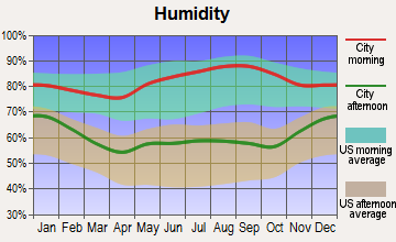
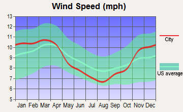
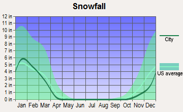
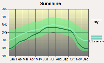
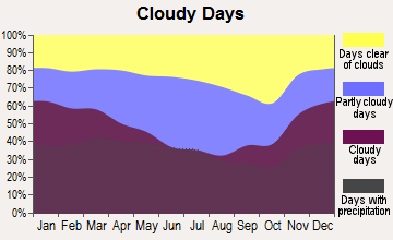
Average climate in Perryville, Kentucky
Based on data reported by over 4,000 weather stations
Tornado activity:
Perryville-area historical tornado activity is near Kentucky state average. It is 38% greater than the overall U.S. average.
On 4/3/1974, a category F4 (max. wind speeds 207-260 mph) tornado 22.2 miles away from the Perryville city center injured 56 people and caused between $500,000 and $5,000,000 in damages.
On 4/3/1974, a category F4 tornado 25.1 miles away from the city center killed 7 people and injured 28 people.
Earthquake activity:
Perryville-area historical earthquake activity is significantly above Kentucky state average. It is 95% greater than the overall U.S. average.On 7/27/1980 at 18:52:21, a magnitude 5.2 (5.1 MB, 4.7 MS, 5.0 UK, 5.2 UK, Class: Moderate, Intensity: VI - VII) earthquake occurred 67.0 miles away from the city center
On 4/18/2008 at 09:36:59, a magnitude 5.4 (5.1 MB, 4.8 MS, 5.4 MW, 5.2 MW) earthquake occurred 169.2 miles away from the city center
On 4/18/2008 at 09:36:59, a magnitude 5.2 (5.2 MW, Depth: 8.9 mi) earthquake occurred 169.2 miles away from the city center
On 9/7/1988 at 02:28:09, a magnitude 4.6 (4.5 MB, 4.6 LG, Class: Light, Intensity: IV - V) earthquake occurred 67.7 miles away from Perryville center
On 6/18/2002 at 17:37:15, a magnitude 5.0 (4.3 MB, 4.6 MW, 5.0 LG) earthquake occurred 156.4 miles away from the city center
On 6/10/1987 at 23:48:54, a magnitude 5.1 (4.9 MB, 4.4 MS, 4.6 MS, 5.1 LG) earthquake occurred 178.8 miles away from Perryville center
Magnitude types: regional Lg-wave magnitude (LG), body-wave magnitude (MB), surface-wave magnitude (MS), moment magnitude (MW)
Natural disasters:
The number of natural disasters in Boyle County (15) is near the US average (15).Major Disasters (Presidential) Declared: 11
Emergencies Declared: 3
Causes of natural disasters: Floods: 7, Storms: 6, Tornadoes: 5, Winter Storms: 5, Mudslides: 3, Blizzard: 1, Freeze: 1, Hurricane: 1, Landslide: 1, Snow: 1, Snowfall: 1, Snowstorm: 1, Other: 1 (Note: some incidents may be assigned to more than one category).
Hospitals and medical centers near Perryville:
- GOLDEN LIVINGCENTER-STANFORD (Nursing Home, about 7 miles away; STANFORD, KY)
- DCI - DANVILLE (Dialysis Facility, about 9 miles away; DANVILLE, KY)
- HAGGIN HOME HEALTH (Home Health Center, about 10 miles away; HARRODSBURG, KY)
- THE JAMES B. HAGGIN MEMORIAL HOSPITAL (Nursing Home, about 10 miles away; HARRODSBURG, KY)
- FMC - DANVILLE (Dialysis Facility, about 10 miles away; DANVILLE, KY)
- CHARLESTON HEALTH CARE CENTER (Nursing Home, about 11 miles away; DANVILLE, KY)
- MCDOWELL HOME HEALTH AGENCY (Home Health Center, about 11 miles away; DANVILLE, KY)
Colleges/universities with over 2000 students nearest to Perryville:
- Campbellsville University (about 31 miles; Campbellsville, KY; Full-time enrollment: 2,948)
- Bluegrass Community and Technical College (about 36 miles; Lexington, KY; FT enrollment: 8,560)
- University of Kentucky (about 36 miles; Lexington, KY; FT enrollment: 23,517)
- Eastern Kentucky University (about 37 miles; Richmond, KY; FT enrollment: 13,525)
- Kentucky State University (about 39 miles; Frankfort, KY; FT enrollment: 2,112)
- Lindsey Wilson College (about 43 miles; Columbia, KY; FT enrollment: 2,552)
- Somerset Community College (about 45 miles; Somerset, KY; FT enrollment: 4,698)
Public elementary/middle school in Perryville:
- PERRYVILLE ELEMENTARY SCHOOL (Students: 259, Location: 418 WEST FOURTH ST, Grades: PK-5)
Points of interest:
Notable location: Perryville Volunteer Fire Department (A). Display/hide its location on the map
Cemetery: Hillcrest Cemetery (1). Display/hide its location on the map
Tourist attractions: Perryville Community Center (Museums; 216 South Buell Street), Perryville Battlefield Historic Site (Cultural Attractions- Events- & Facilities; Mackville Road).
Hotel: Elmwood Inn (205 East 4th Street).
| This city: | 2.3 people |
| Kentucky: | 2.5 people |
| This city: | 65.6% |
| Whole state: | 66.9% |
| This city: | 5.2% |
| Whole state: | 6.4% |
No gay or lesbian households reported
Banks with branches in Perryville (2011 data):
- The Farmers National Bank of Danville: Perryville Branch at 309 East Second Street, branch established on 1986/12/15. Info updated 2006/11/03: Bank assets: $479.5 mil, Deposits: $412.6 mil, headquarters in Danville, KY, positive income, 11 total offices, Holding Company: Boyle Bancorp, Inc.
| Here: | 8.6 |
| Kentucky average: | 11.7 |
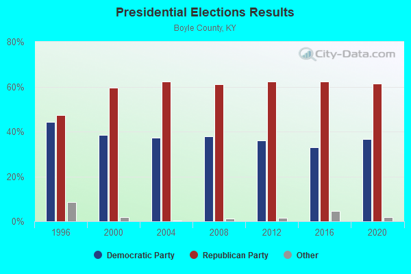

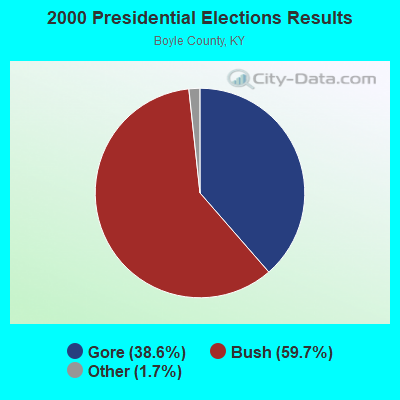
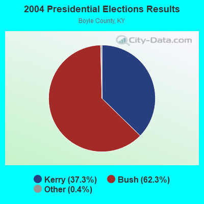
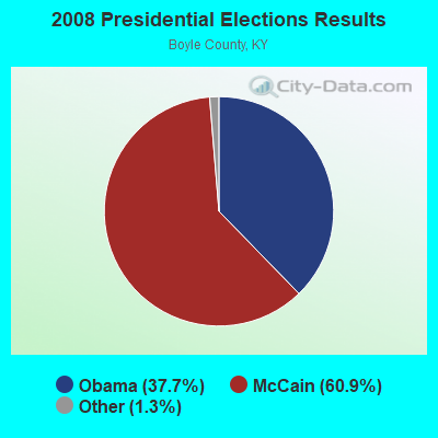
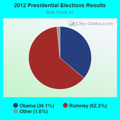
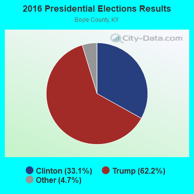
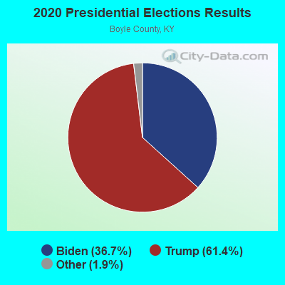
Graphs represent county-level data. Detailed 2008 Election Results
Religion statistics for Perryville, KY (based on Boyle County data)
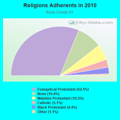
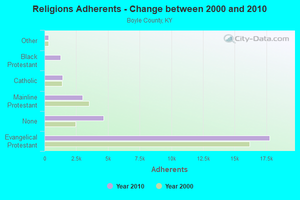
| Religion | Adherents | Congregations |
|---|---|---|
| Evangelical Protestant | 17,762 | 51 |
| Mainline Protestant | 2,992 | 11 |
| Catholic | 1,439 | 2 |
| Black Protestant | 1,253 | 3 |
| Other | 323 | 3 |
| None | 4,663 | - |
Food Environment Statistics:
| Here: | 2.44 / 10,000 pop. |
| Kentucky: | 2.19 / 10,000 pop. |
| Boyle County: | 0.35 / 10,000 pop. |
| Kentucky: | 0.25 / 10,000 pop. |
| This county: | 0.35 / 10,000 pop. |
| Kentucky: | 0.74 / 10,000 pop. |
| This county: | 5.93 / 10,000 pop. |
| Kentucky: | 4.36 / 10,000 pop. |
| Boyle County: | 8.02 / 10,000 pop. |
| Kentucky: | 5.74 / 10,000 pop. |
| Boyle County: | 10.9% |
| Kentucky: | 11.0% |
| Here: | 28.8% |
| Kentucky: | 30.0% |
| Boyle County: | 17.3% |
| State: | 15.9% |
Health and Nutrition:
| Perryville: | 49.6% |
| State: | 49.9% |
| Perryville: | 43.2% |
| Kentucky: | 47.0% |
| Perryville: | 29.0 |
| Kentucky: | 28.6 |
| Perryville: | 17.5% |
| Kentucky: | 21.0% |
| This city: | 8.7% |
| Kentucky: | 10.1% |
| Perryville: | 6.8 |
| Kentucky: | 6.8 |
| This city: | 29.1% |
| State: | 33.8% |
| Perryville: | 57.5% |
| Kentucky: | 56.8% |
| This city: | 75.5% |
| Kentucky: | 78.9% |
More about Health and Nutrition of Perryville, KY Residents
| Local government employment and payroll (March 2022) | |||||
| Function | Full-time employees | Monthly full-time payroll | Average yearly full-time wage | Part-time employees | Monthly part-time payroll |
|---|---|---|---|---|---|
| Police Protection - Officers | 1 | $2,622 | $31,464 | 2 | $2,229 |
| Streets and Highways | 1 | $2,317 | $27,804 | 0 | $0 |
| Other Government Administration | 0 | $0 | 1 | $672 | |
| Firefighters | 0 | $0 | 1 | $834 | |
| Totals for Government | 2 | $4,939 | $29,634 | 4 | $3,735 |
Perryville government finances - Expenditure in 2017 (per resident):
- Current Operations - Central Staff Services: $121,000 ($152.78)
Solid Waste Management: $41,000 ($51.77)
Police Protection: $39,000 ($49.24)
Local Fire Protection: $18,000 ($22.73)
Financial Administration: $6,000 ($7.58)
Regular Highways: $3,000 ($3.79)
- General - Interest on Debt: $15,000 ($18.94)
- Other Capital Outlay - Local Fire Protection: $26,000 ($32.83)
- Total Salaries and Wages: $88,000 ($111.11)
Perryville government finances - Revenue in 2017 (per resident):
- Local Intergovernmental - General Local Government Support: $4,000 ($5.05)
- Miscellaneous - Rents: $12,000 ($15.15)
Interest Earnings: $3,000 ($3.79)
Donations From Private Sources: $1,000 ($1.26)
- State Intergovernmental - Other: $25,000 ($31.57)
Highways: $15,000 ($18.94)
- Tax - Property: $114,000 ($143.94)
Insurance Premiums Sales: $82,000 ($103.54)
Individual Income: $33,000 ($41.67)
Public Utilities Sales: $19,000 ($23.99)
Occupation and Business License - Other: $1,000 ($1.26)
Perryville government finances - Debt in 2017 (per resident):
- Long Term Debt - Beginning Outstanding - Unspecified Public Purpose: $376,000 ($474.75)
Outstanding Unspecified Public Purpose: $368,000 ($464.65)
Retired Unspecified Public Purpose: $8,000 ($10.10)
Perryville government finances - Cash and Securities in 2017 (per resident):
- Other Funds - Cash and Securities: $368,000 ($464.65)
Businesses in Perryville, KY
- Lane Furniture: 1
Strongest AM radio stations in Perryville:
- WHAS (840 AM; 50 kW; LOUISVILLE, KY; Owner: CLEAR CHANNEL BROADCASTING LICENSES, INC.)
- WDFB (1170 AM; daytime; 1 kW; JUNCTION CITY, KY; Owner: ALUM SPRINGS VISION & OUTREACH CORP)
- WHIR (1230 AM; 1 kW; DANVILLE, KY; Owner: HOMETOWN B/CSTNG OF DANVILLE, INC.)
- WHBN (1420 AM; 1 kW; HARRODSBURG, KY; Owner: MORTENSON BROADCASTING COMPANY OF KE)
- WVLK (590 AM; 5 kW; LEXINGTON, KY; Owner: CUMULUS LICENSING CORP.)
- WLW (700 AM; 50 kW; CINCINNATI, OH; Owner: JACOR BROADCASTING CORPORATION)
- WLAP (630 AM; 5 kW; LEXINGTON, KY; Owner: CITICASTERS LICENSES, L.P.)
- WXRA (1580 AM; 10 kW; GEORGETOWN, KY; Owner: CITICASTERS LICENSES, L.P.)
- WKVL (850 AM; daytime; 50 kW; KNOXVILLE, TN; Owner: HORNE RADIO, LLC)
- WSAI (1530 AM; 50 kW; CINCINNATI, OH; Owner: JACOR BROADCASTING CORPORATION)
- WSM (650 AM; 50 kW; NASHVILLE, TN; Owner: GAYLORD ENTERTAINMENT COMPANY)
- WXXA (790 AM; 5 kW; LOUISVILLE, KY)
- WTVN (610 AM; 50 kW; COLUMBUS, OH; Owner: CITICASTERS LICENSES, L.P.)
Strongest FM radio stations in Perryville:
- WXKY-FM (96.3 FM; STANFORD, KY; Owner: LINCOLN-GARRARD BROADCASTING CO.,INC)
- WDFB-FM (88.1 FM; DANVILLE, KY; Owner: ALUM SPRINGS EDUCATIONAL CORPORATION)
- WHIR-FM (107.1 FM; DANVILLE, KY; Owner: CLEAR CHANNEL BROADCASTING LICENSES, INC.)
- WJMM-FM (99.3 FM; HARRODSBURG, KY; Owner: MORTENSON BROADCASTING COMPANY OF CENTRAL KENTUCKY, LLC)
- WUKY (91.3 FM; LEXINGTON, KY; Owner: BD. OF TRUSTEES UNIV. OF KENTUCKY)
- WVLC (99.9 FM; MANNSVILLE, KY; Owner: PATRICIA RODGERS)
- WAKY-FM (102.7 FM; SPRINGFIELD, KY; Owner: WASHINGTON COUNTY CBC, INC.)
- WLSK (100.9 FM; LEBANON, KY; Owner: CBC OF MARION COUNTY, INC)
- WVLK-FM (92.9 FM; LEXINGTON, KY; Owner: CUMULUS LICENSING CORP.)
- WRNZ (105.1 FM; LANCASTER, KY; Owner: HOMETOWN BROADCASTING OF LANCASTER, INC.)
- WEKU (88.9 FM; RICHMOND, KY; Owner: EASTERN KENTUCKY UNIVERSITY)
TV broadcast stations around Perryville:
- WDKY-TV (Channel 56; DANVILLE, KY; Owner: WDKY LICENSEE, LLC)
- WBKI-TV (Channel 34; CAMPBELLSVILLE, KY; Owner: LOUISVILLE COMMUNICATIONS, LLC)
- WKSO-TV (Channel 29; SOMERSET, KY; Owner: KENTUCKY AUTHORITY FOR EDUCATIONAL TV)
- WKYT-TV (Channel 27; LEXINGTON, KY; Owner: WKYT LICENSEE CORP.)
- WKLE (Channel 46; LEXINGTON, KY; Owner: KENTUCKY AUTHORITY FOR EDUCATIONAL TV)
- WTVQ-TV (Channel 36; LEXINGTON, KY; Owner: MEDIA GENERAL COMMUNICATIONS, INC.)
Perryville fatal accident list:
Jul 19, 2014 10:35 AM, Us-68, Lat: 37.650400, Lon: -84.951450, Vehicles: 1, Persons: 1, Fatalities: 1
Mar 31, 2000 01:00 PM, Us-150, Vehicles: 2, Persons: 5, Fatalities: 2
Jan 2, 1988 09:33 AM, 150, Vehicles: 1, Persons: 2, Fatalities: 1
- National Bridge Inventory (NBI) Statistics
- 24Number of bridges
- 112ft / 34.5mTotal length
- $708,000Total costs
- 8,549Total average daily traffic
- 597Total average daily truck traffic
- 10,658Total future (year 2026) average daily traffic
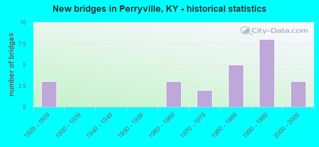
- New bridges - historical statistics
- 31920-1929
- 31960-1969
- 21970-1979
- 51980-1989
- 81990-1999
- 32000-2009
FCC Registered Cell Phone Towers:
2 (See the full list of FCC Registered Cell Phone Towers in Perryville)FCC Registered Antenna Towers:
14 (See the full list of FCC Registered Antenna Towers)FCC Registered Broadcast Land Mobile Towers:
3- 100 Ft Off Hwy 442 4.85 Mi Nw (Lat: 37.662583 Lon: -85.036917), Call Sign: KNBG482, Licensee ID: L00003833,
Assigned Frequencies: 47.9400 MHz, Grant Date: 06/21/2001, Expiration Date: 08/29/2011, Cancellation Date: 06/20/2011, Registrant: East Kentucky Power Cooperative Inc, 4775 Lexington Road, Winchester, KY 40392-0707, Phone: (859) 745-9391, Fax: (859) 744-6008, Email:
- 9445 Perryville Rd (Lat: 37.653167 Lon: -84.940028), Type: Pole, Structure height: 6 m, Call Sign: WQPY201,
Assigned Frequencies: 4945.00 MHz, Grant Date: 08/30/2022, Expiration Date: 09/14/2032, Certifier: Bernie Hunstad, Registrant: City Of Danville, 445 W. Main St., Danville, KY 40422, Phone: (859) 238-1200, Email:
- Lat: 37.648583 Lon: -84.956111, Call Sign: WQWA911,
Assigned Frequencies: 159.990 MHz, 159.840 MHz, 159.825 MHz, 160.140 MHz, 151.790 MHz, Grant Date: 07/06/2015, Expiration Date: 07/06/2025, Certifier: Terressa Barker, Registrant: Rcs Communications, 4445 Robards Lane, Louisville, KY 40218, Phone: (859) 254-0443, Email:
FCC Registered Microwave Towers:
6- Various Locations (Lat: 37.662556 Lon: -85.036889), Overall height: 6.1 m, Call Sign: WPNI438,
Assigned Frequencies: 956.343 MHz, Grant Date: 01/06/2023, Expiration Date: 03/20/2033, Registrant: Keller And Heckman LLP, 1001 G Street Nw, Suite 500 West, Washington, DC 20001, Phone: (202) 434-4100, Fax: (202) 434-4646, Email:
- Beech Grove, Off Ky Hwy 442, 4.8 Mi Nw Of (Lat: 37.662556 Lon: -85.036889), Type: Tower, Structure height: 48.8 m, Overall height: 49.4 m, Call Sign: WPWE989,
Assigned Frequencies: 6226.89 MHz, 6404.79 MHz, Grant Date: 11/01/2002, Expiration Date: 11/01/2012, Cancellation Date: 04/27/2013, Certifier: Terry E Estes, Registrant: Utility Telecom Consulting Group, Inc., 1554 St. Paul Street, Denver, CO 80206, Phone: (303) 840-2878, Fax: (303) 840-1028, Email:
- Beech Grove, Off Ky Hwy 442, 4.8 Mi Nw Of Perryville, Ky (Lat: 37.659778 Lon: -85.036889), Type: Gtower, Structure height: 48.8 m, Overall height: 49.4 m, Call Sign: WQQW779,
Assigned Frequencies: 6226.89 MHz, 6404.79 MHz, Grant Date: 03/18/2013, Expiration Date: 09/14/2013, Cancellation Date: 11/16/2013, Certifier: Jason Witt, Registrant: Greenberg Traurig, LLP, 2101 L Street, Nw, Suite 1000, Washington, DC 20037, Phone: (202) 331-3194, Fax: (202) 331-0310, Email:
- Beech Grove, Off Ky Hwy 442, 4.8 Miles Nw Of (Lat: 37.662556 Lon: -85.036889), Type: Gtower, Structure height: 48.8 m, Overall height: 49.4 m, Call Sign: WQRR416,
Assigned Frequencies: 6226.89 MHz, 6404.79 MHz, Grant Date: 07/11/2023, Expiration Date: 07/12/2033, Certifier: Terry E Estes, Registrant: Utility Telecom Consulting Group, Inc., 9850 S Maryland Pkwy Ste A5-108, Las Vegas, NV 89183, Phone: (702) 340-1706, Email:
- Beech Grove, 100 Ft W Of Hwy Ky 442 1.1 Mi N Hwy Us 150 (Lat: 37.662583 Lon: -85.037028), Type: Ltower, Structure height: 68.6 m, Overall height: 71.7 m, Call Sign: KIP33,
Assigned Frequencies: 6785.00 MHz, 6845.00 MHz, 6197.24 MHz, 6286.19 MHz, 6315.84 MHz, 6345.49 MHz, Grant Date: 10/27/2022, Expiration Date: 01/20/2033, Registrant: Keller And Heckman LLP, 1001 G Street Nw, Suite 500 West, Washington, DC 20001, Phone: (202) 434-4100, Fax: (202) 434-4646, Email:
- STATION, 100 Ft Off Ky Hwy 442 4.85 Nw Of (Lat: 37.662556 Lon: -85.036889), Overall height: 49.4 m, Call Sign: WIA449,
Assigned Frequencies: 6815.00 MHz, 6795.00 MHz, Grant Date: 09/17/1999, Expiration Date: 11/10/2009, Cancellation Date: 04/04/2008, Phone: (606) 744-4812
FCC Registered Amateur Radio Licenses:
6- Call Sign: KC4PQS, Licensee ID: L00494954, Grant Date: 04/03/2002, Expiration Date: 06/30/2012, Cancellation Date: 07/01/2014, Certifier: Terry A Reynolds, Registrant: Terry A Reynolds, 151 Southern Dr, Perryville, KY 40468
- Call Sign: KE4IJD, Licensee ID: L00747172, Grant Date: 09/24/2013, Expiration Date: 12/21/2023, Certifier: Jesse W Purdy, Registrant: Jesse W Purdy, Perryville, KY 40468
- Call Sign: N4EOX, Licensee ID: L00273260, Grant Date: 09/01/2020, Expiration Date: 10/02/2030, Certifier: Lawrence E Lovely, Registrant: Lawrence E Lovely, 401 Buckner St., Perryville, KY 40468
- Call Sign: W4UTC, Grant Date: 08/21/1995, Expiration Date: 08/21/2005, Cancellation Date: 08/22/2007, Registrant: George R Sandidge Jr, 111 Stewart Rd, Perryville, KY 40468
- Call Sign: KJ4BMB, Licensee ID: L01361076, Grant Date: 01/05/2018, Expiration Date: 01/22/2028, Certifier: Baruch A Myers, Registrant: Baruch A Myers, 107a S Braxton St, Perryville, KY 40468
- Call Sign: KJ4LJY, Licensee ID: L01484796, Grant Date: 04/21/2009, Expiration Date: 04/21/2019, Cancellation Date: 04/22/2021, Certifier: David W Hastings Jr, Registrant: David W Hastings Jr, 506 East Third St, Perryville, KY 40468
FAA Registered Aircraft:
1- Aircraft: WILKE MARK CHALLENGER II STANDA (Category: Land, Seats: 2, Weight: Up to 12,499 Pounds), Engine: BOMBARDIER ROTAX (ALL) (Reciprocating)
N-Number: 5056W, N5056W, N-5056W, Serial Number: CH212951435, Year manufactured: 1996, Airworthiness Date: 04/25/1998, Certificate Issue Date: 02/10/2020
Registrant (Individual): Wayne R Collins, 533 S Buell St, Perryville, KY 40468
2002 - 2018 National Fire Incident Reporting System (NFIRS) incidents
- Fire incident types reported to NFIRS in Perryville, KY
- 5743.5%Structure Fires
- 4735.9%Outside Fires
- 1612.2%Mobile Property/Vehicle Fires
- 118.4%Other
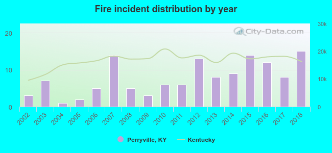 According to the data from the years 2002 - 2018 the average number of fires per year is 8. The highest number of reported fire incidents - 15 took place in 2018, and the least - 1 in 2004. The data has a rising trend.
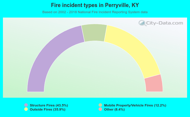 When looking into fire subcategories, the most reports belonged to: Structure Fires (43.5%), and Outside Fires (35.9%).
| Most common first names in Perryville, KY among deceased individuals | ||
| Name | Count | Lived (average) |
|---|---|---|
| William | 22 | 73.4 years |
| Mary | 17 | 69.1 years |
| John | 17 | 79.2 years |
| James | 16 | 75.9 years |
| George | 11 | 77.1 years |
| Robert | 10 | 76.5 years |
| Charles | 8 | 65.2 years |
| Hazel | 6 | 82.5 years |
| Helen | 6 | 72.0 years |
| Margaret | 6 | 78.0 years |
| Most common last names in Perryville, KY among deceased individuals | ||
| Last name | Count | Lived (average) |
|---|---|---|
| Harmon | 16 | 81.4 years |
| Gibson | 16 | 79.8 years |
| Crain | 15 | 80.5 years |
| Webb | 14 | 73.1 years |
| Bottoms | 13 | 74.4 years |
| Carpenter | 13 | 76.2 years |
| Coyle | 13 | 81.7 years |
| White | 11 | 83.3 years |
| Reynolds | 11 | 72.5 years |
| Arnold | 10 | 76.4 years |
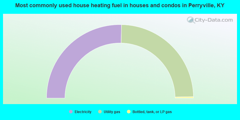
- 50.6%Electricity
- 48.7%Utility gas
- 0.6%Bottled, tank, or LP gas
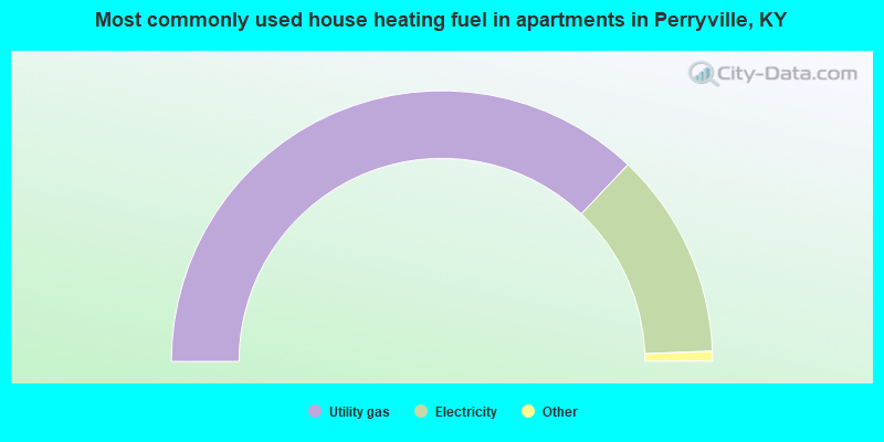
- 75.0%Utility gas
- 25.0%Electricity
Perryville compared to Kentucky state average:
- Median house value below state average.
- Unemployed percentage significantly below state average.
- Hispanic race population percentage significantly below state average.
- Foreign-born population percentage significantly below state average.
- Length of stay since moving in significantly below state average.
- House age above state average.
- Number of college students below state average.
- Percentage of population with a bachelor's degree or higher above state average.

|
Total of 6 patent applications in 2008-2024.