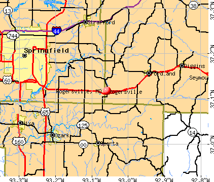
Rogersville, Missouri

Rogersville: An ex-Amish man makes use of his last Amish clothes to protect his raised gardens
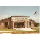
Rogersville: ROGERSVILLE, MO POST OFFICE
- add
your
Submit your own pictures of this city and show them to the world
- OSM Map
- General Map
- Google Map
- MSN Map
Population change since 2000: +223.9%
| Males: 2,558 | |
| Females: 2,326 |
| Median resident age: | 29.2 years |
| Missouri median age: | 39.1 years |
Zip codes: 65742.
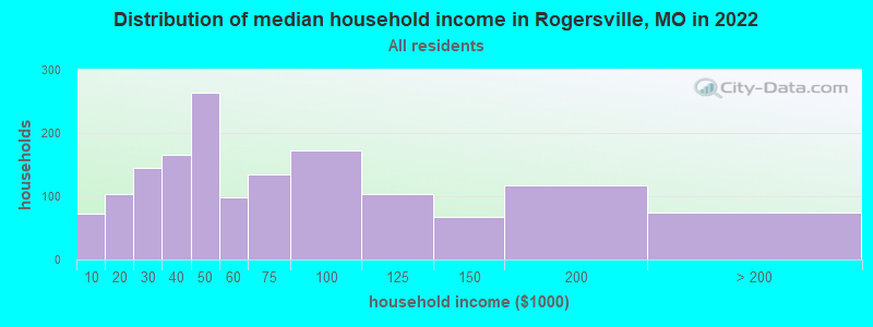
| Rogersville: | $49,728 |
| MO: | $64,811 |
Estimated per capita income in 2022: $27,444 (it was $16,173 in 2000)
Rogersville city income, earnings, and wages data
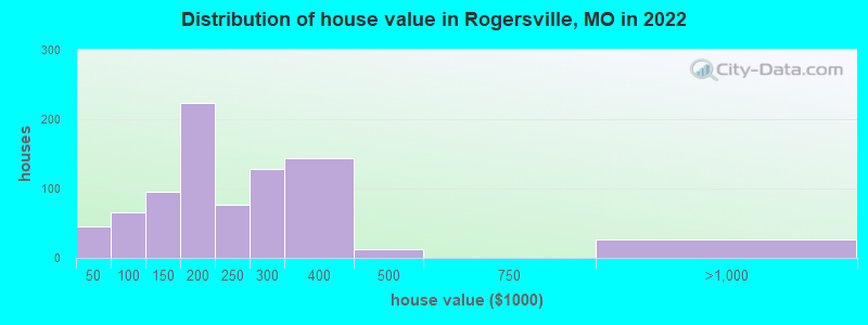
Estimated median house or condo value in 2022: $190,250 (it was $77,200 in 2000)
| Rogersville: | $190,250 |
| MO: | $221,200 |
Mean prices in 2022: all housing units: $224,932; detached houses: $224,218; townhouses or other attached units: $254,023
Median gross rent in 2022: $792.
Detailed information about poverty and poor residents in Rogersville, MO


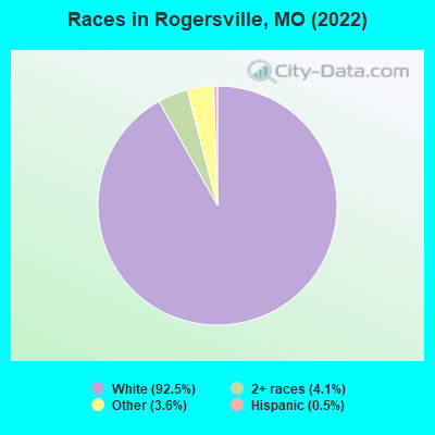
- 4,01692.5%White alone
- 1764.1%Two or more races
- 1583.6%Other race alone
- 210.5%Hispanic
Races in Rogersville detailed stats: ancestries, foreign born residents, place of birth
According to our research of Missouri and other state lists, there were 30 registered sex offenders living in Rogersville, Missouri as of April 27, 2024.
The ratio of all residents to sex offenders in Rogersville is 121 to 1.
Type |
2009 |
2010 |
2011 |
2012 |
2013 |
2014 |
2015 |
2016 |
2017 |
2018 |
2019 |
2020 |
2021 |
2022 |
|---|---|---|---|---|---|---|---|---|---|---|---|---|---|---|
| Murders (per 100,000) | 0 (0.0) | 1 (32.5) | 0 (0.0) | 1 (32.2) | 0 (0.0) | 0 (0.0) | 0 (0.0) | 0 (0.0) | 1 (27.8) | 0 (0.0) | 0 (0.0) | 0 (0.0) | 0 (0.0) | 0 (0.0) |
| Rapes (per 100,000) | 1 (30.5) | 0 (0.0) | 0 (0.0) | 0 (0.0) | 0 (0.0) | 0 (0.0) | 1 (29.7) | 1 (29.1) | 0 (0.0) | 0 (0.0) | 0 (0.0) | 0 (0.0) | 2 (49.4) | 4 (80.5) |
| Robberies (per 100,000) | 0 (0.0) | 0 (0.0) | 1 (32.4) | 0 (0.0) | 0 (0.0) | 0 (0.0) | 0 (0.0) | 0 (0.0) | 0 (0.0) | 0 (0.0) | 0 (0.0) | 1 (25.3) | 0 (0.0) | 0 (0.0) |
| Assaults (per 100,000) | 3 (91.5) | 7 (227.8) | 3 (97.3) | 3 (96.7) | 1 (30.6) | 4 (120.7) | 4 (118.8) | 5 (145.5) | 4 (111.2) | 3 (80.2) | 4 (102.9) | 5 (126.3) | 14 (345.6) | 7 (140.8) |
| Burglaries (per 100,000) | 18 (549.1) | 17 (553.2) | 16 (518.8) | 13 (419.2) | 12 (367.4) | 15 (452.6) | 18 (534.4) | 7 (203.7) | 10 (277.9) | 16 (427.9) | 9 (231.5) | 6 (151.5) | 9 (222.2) | 11 (221.2) |
| Thefts (per 100,000) | 72 (2,196) | 100 (3,254) | 68 (2,205) | 79 (2,548) | 87 (2,664) | 46 (1,388) | 51 (1,514) | 86 (2,503) | 69 (1,918) | 30 (802.4) | 40 (1,029) | 46 (1,162) | 39 (962.7) | 27 (543.0) |
| Auto thefts (per 100,000) | 6 (183.0) | 5 (162.7) | 1 (32.4) | 4 (129.0) | 5 (153.1) | 4 (120.7) | 4 (118.8) | 7 (203.7) | 11 (305.7) | 7 (187.2) | 5 (128.6) | 4 (101.0) | 4 (98.7) | 4 (80.5) |
| Arson (per 100,000) | 0 (0.0) | 0 (0.0) | 0 (0.0) | 3 (96.7) | 0 (0.0) | 0 (0.0) | 0 (0.0) | 0 (0.0) | 0 (0.0) | 0 (0.0) | 0 (0.0) | 0 (0.0) | 0 (0.0) | 1 (20.1) |
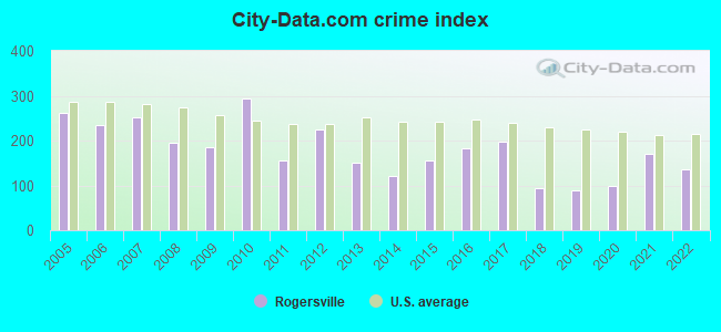
| City-Data.com crime index | 183.6 | 292.5 | 156.3 | 225.4 | 150.6 | 121.0 | 155.0 | 183.1 | 198.4 | 93.1 | 88.2 | 98.0 | 170.6 | 136.2 |
The City-Data.com crime index weighs serious crimes and violent crimes more heavily. Higher means more crime, U.S. average is 246.1. It adjusts for the number of visitors and daily workers commuting into cities.
Crime rate in Rogersville detailed stats: murders, rapes, robberies, assaults, burglaries, thefts, arson
Full-time law enforcement employees in 2020, including police officers: 10 (10 officers - 10 male; 0 female).
| Officers per 1,000 residents here: | 2.53 |
| Missouri average: | 2.53 |
 Recent articles from our blog. Our writers, many of them Ph.D. graduates or candidates, create easy-to-read articles on a wide variety of topics.

 | Springfield, MO Crime Rate (Is it Really That Bad?) (24 replies) |
| How Bad Is Branson Traffic If You Live There? (8 replies) |
| Worth exploring Springfield? (24 replies) |
| Rogersville, Mo...Need Info... (4 replies) |
| Rural areas around Springfield (16 replies) |
| Young family considering a move to a town nearby (7 replies) |
Latest news from Rogersville, MO collected exclusively by city-data.com from local newspapers, TV, and radio stations
Ancestries: German (22.1%), Irish (15.5%), English (12.9%), American (7.8%), Scottish (5.5%), European (4.9%).
Current Local Time: CST time zone
Incorporated in 1945
Elevation: 1450 feet
Land area: 1.14 square miles.
Population density: 4,270 people per square mile (average).
15 residents are foreign born
| This city: | 0.3% |
| Missouri: | 4.2% |
| Rogersville city: | 0.6% ($499) |
| Missouri: | 1.0% ($851) |
Nearest city with pop. 50,000+: Springfield, MO  (13.7 miles , pop. 151,580).
Nearest city with pop. 200,000+: Kansas City, MO (158.1 miles , pop. 441,545).
Nearest city with pop. 1,000,000+: Dallas, TX (365.8 miles , pop. 1,188,580).
Nearest cities:
), Latitude: 37.12 N, Longitude: 93.06 W
Area code: 417
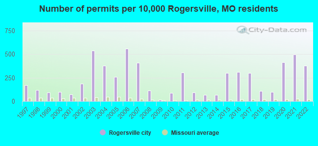
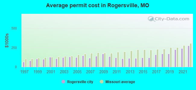
Single-family new house construction building permits:
- 2022: 57 buildings, average cost: $274,000
- 2021: 75 buildings, average cost: $238,500
- 2020: 62 buildings, average cost: $225,700
- 2019: 15 buildings, average cost: $170,600
- 2018: 16 buildings, average cost: $170,600
- 2017: 45 buildings, average cost: $160,400
- 2016: 47 buildings, average cost: $122,300
- 2015: 45 buildings, average cost: $122,300
- 2014: 10 buildings, average cost: $112,000
- 2013: 10 buildings, average cost: $112,000
- 2012: 14 buildings, average cost: $109,300
- 2011: 46 buildings, average cost: $120,000
- 2010: 13 buildings, average cost: $137,300
- 2009: 2 buildings, average cost: $170,000
- 2008: 17 buildings, average cost: $140,500
- 2007: 61 buildings, average cost: $117,400
- 2006: 84 buildings, average cost: $149,000
- 2005: 39 buildings, average cost: $123,900
- 2004: 57 buildings, average cost: $129,600
- 2003: 81 buildings, average cost: $122,900
- 2002: 28 buildings, average cost: $107,500
- 2001: 11 buildings, average cost: $125,800
- 2000: 15 buildings, average cost: $99,900
- 1999: 14 buildings, average cost: $105,000
- 1998: 18 buildings, average cost: $82,700
- 1997: 26 buildings, average cost: $65,400
| Here: | 2.3% |
| Missouri: | 2.8% |
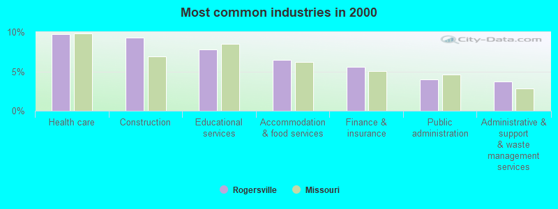
- Health care (9.7%)
- Construction (9.3%)
- Educational services (7.8%)
- Accommodation & food services (6.5%)
- Finance & insurance (5.6%)
- Public administration (4.0%)
- Administrative & support & waste management services (3.7%)
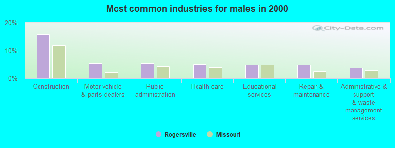
- Construction (15.8%)
- Motor vehicle & parts dealers (5.5%)
- Public administration (5.5%)
- Health care (5.2%)
- Educational services (4.9%)
- Repair & maintenance (4.9%)
- Administrative & support & waste management services (3.8%)
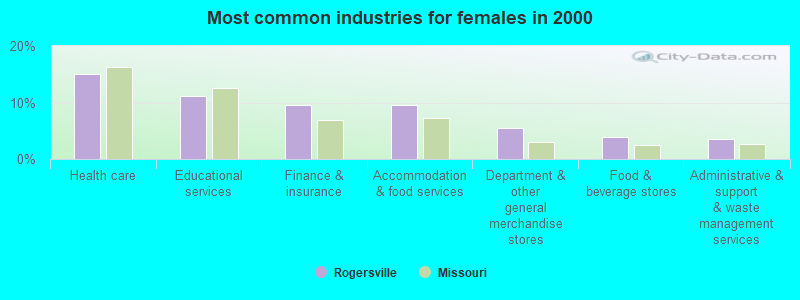
- Health care (15.0%)
- Educational services (11.2%)
- Finance & insurance (9.6%)
- Accommodation & food services (9.6%)
- Department & other general merchandise stores (5.4%)
- Food & beverage stores (3.8%)
- Administrative & support & waste management services (3.5%)
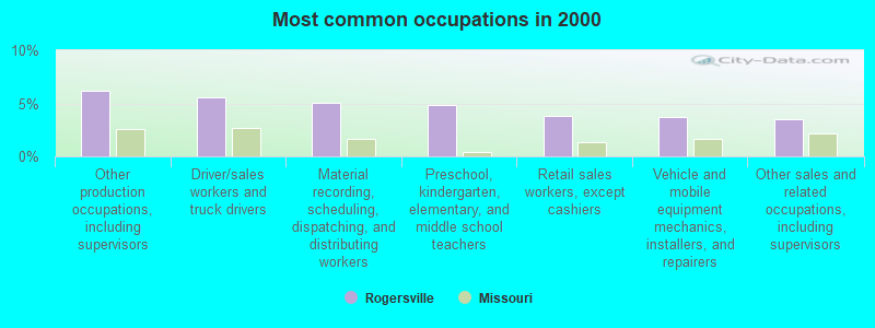
- Other production occupations, including supervisors (6.2%)
- Driver/sales workers and truck drivers (5.6%)
- Material recording, scheduling, dispatching, and distributing workers (5.0%)
- Preschool, kindergarten, elementary, and middle school teachers (4.9%)
- Retail sales workers, except cashiers (3.8%)
- Vehicle and mobile equipment mechanics, installers, and repairers (3.7%)
- Other sales and related occupations, including supervisors (3.5%)
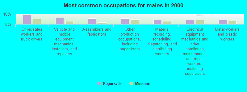
- Driver/sales workers and truck drivers (9.0%)
- Vehicle and mobile equipment mechanics, installers, and repairers (6.3%)
- Assemblers and fabricators (5.7%)
- Other production occupations, including supervisors (5.7%)
- Material recording, scheduling, dispatching, and distributing workers (4.6%)
- Electrical equipment mechanics and other installation, maintenance, and repair workers, including supervisors (4.6%)
- Metal workers and plastic workers (4.1%)
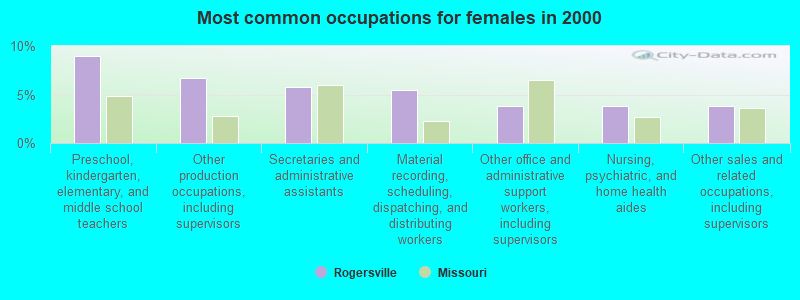
- Preschool, kindergarten, elementary, and middle school teachers (8.9%)
- Other production occupations, including supervisors (6.7%)
- Secretaries and administrative assistants (5.8%)
- Material recording, scheduling, dispatching, and distributing workers (5.4%)
- Other office and administrative support workers, including supervisors (3.8%)
- Nursing, psychiatric, and home health aides (3.8%)
- Other sales and related occupations, including supervisors (3.8%)
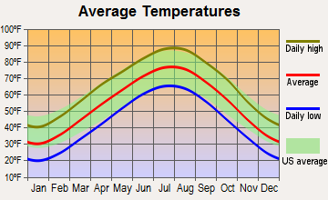
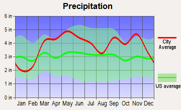
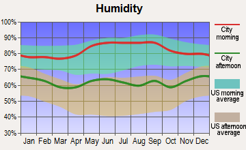
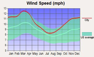
Average climate in Rogersville, Missouri
Based on data reported by over 4,000 weather stations
|
|

(lower is better)
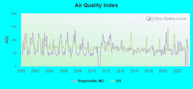
Air Quality Index (AQI) level in 2022 was 70.1. This is about average.
| City: | 70.1 |
| U.S.: | 72.6 |
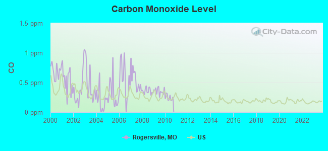
Carbon Monoxide (CO) [ppm] level in 2010 was 0.246. This is about average. Closest monitor was 12.1 miles away from the city center.
| City: | 0.246 |
| U.S.: | 0.251 |
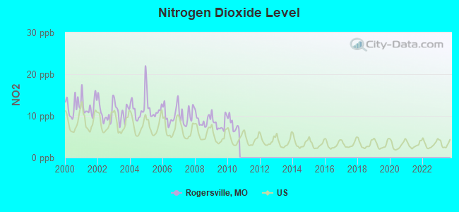
Nitrogen Dioxide (NO2) [ppb] level in 2010 was 7.97. This is significantly worse than average. Closest monitor was 12.1 miles away from the city center.
| City: | 7.97 |
| U.S.: | 5.11 |
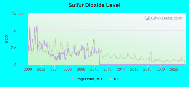
Sulfur Dioxide (SO2) [ppb] level in 2010 was 1.84. This is worse than average. Closest monitor was 10.9 miles away from the city center.
| City: | 1.84 |
| U.S.: | 1.51 |
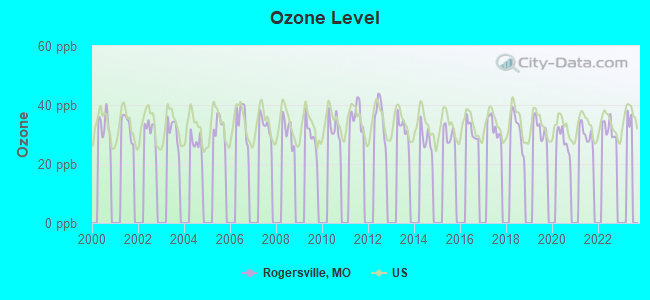
Ozone [ppb] level in 2022 was 31.8. This is about average. Closest monitor was 11.3 miles away from the city center.
| City: | 31.8 |
| U.S.: | 33.3 |
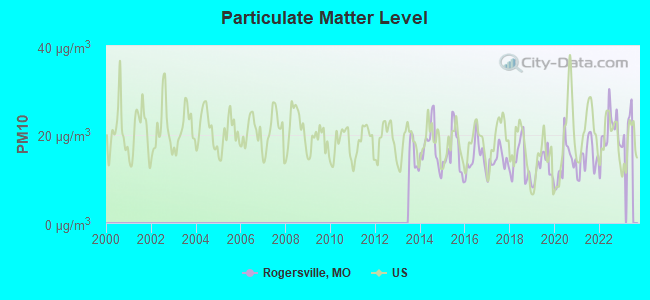
Particulate Matter (PM10) [µg/m3] level in 2022 was 20.4. This is about average. Closest monitor was 13.7 miles away from the city center.
| City: | 20.4 |
| U.S.: | 19.2 |
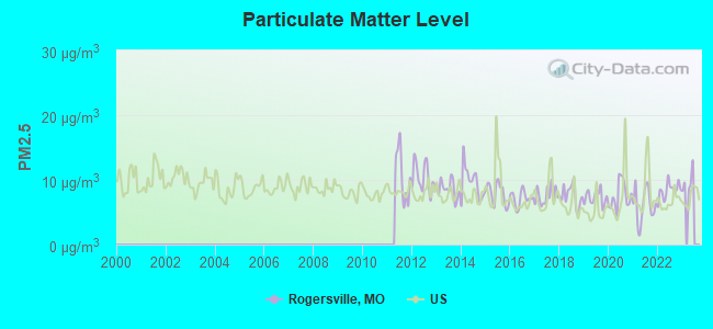
Particulate Matter (PM2.5) [µg/m3] level in 2022 was 8.38. This is about average. Closest monitor was 13.7 miles away from the city center.
| City: | 8.38 |
| U.S.: | 8.11 |
Tornado activity:
Rogersville-area historical tornado activity is slightly below Missouri state average. It is 34% greater than the overall U.S. average.
On 11/29/1991, a category F4 (max. wind speeds 207-260 mph) tornado 10.6 miles away from the Rogersville city center killed 2 people and injured 64 people and caused between $5,000,000 and $50,000,000 in damages.
On 9/26/1959, a category F4 tornado 26.8 miles away from the city center caused between $50,000 and $500,000 in damages.
Earthquake activity:
Rogersville-area historical earthquake activity is significantly above Missouri state average. It is 545% greater than the overall U.S. average.On 9/3/2016 at 12:02:44, a magnitude 5.8 (5.8 MW, Depth: 3.5 mi, Class: Moderate, Intensity: VI - VII) earthquake occurred 219.7 miles away from Rogersville center
On 11/6/2011 at 03:53:10, a magnitude 5.7 (5.7 MW, Depth: 3.2 mi) earthquake occurred 233.8 miles away from the city center
On 5/4/1991 at 01:18:54, a magnitude 5.0 (4.4 MB, 4.6 LG, 5.0 LG, Depth: 3.1 mi) earthquake occurred 183.1 miles away from Rogersville center
On 3/25/1976 at 00:41:20, a magnitude 5.0 (4.9 MB, 5.0 LG) earthquake occurred 183.3 miles away from the city center
On 2/28/2011 at 05:00:50, a magnitude 4.7 (4.7 MW, Depth: 2.0 mi, Class: Light, Intensity: IV - V) earthquake occurred 133.8 miles away from the city center
On 9/26/1990 at 13:18:51, a magnitude 5.0 (4.7 MB, 4.8 LG, 5.0 LG, Depth: 7.7 mi) earthquake occurred 194.3 miles away from Rogersville center
Magnitude types: regional Lg-wave magnitude (LG), body-wave magnitude (MB), moment magnitude (MW)
Natural disasters:
The number of natural disasters in Webster County (28) is a lot greater than the US average (15).Major Disasters (Presidential) Declared: 19
Emergencies Declared: 6
Causes of natural disasters: Floods: 21, Storms: 19, Tornadoes: 14, Winds: 6, Winter Storms: 5, Drought: 1, Heavy Rain: 1, Hurricane: 1, Other: 1 (Note: some incidents may be assigned to more than one category).
Hospitals and medical centers near Rogersville:
- JAMES RIVER CARE AND REHABILITATION CENTER, INC (Nursing Home, about 10 miles away; SPRINGFIELD, MO)
- CHRISTIAN HEALTH AND REHAB OF SPRINGFIELD EAST (Nursing Home, about 10 miles away; SPRINGFIELD, MO)
- OZARK NURSING AND CARE CENTER (Nursing Home, about 11 miles away; OZARK, MO)
- OZARK NURSING AND CARE CTR (Nursing Home, about 11 miles away; OZARK, MO)
- OZARK RIVERVIEW MANOR (Nursing Home, about 11 miles away; OZARK, MO)
- STRAFFORD CARE CENTER (Nursing Home, about 12 miles away; STRAFFORD, MO)
- HOSPICE AND PALLIATIVE CARE OF SPRINGFIELD LLC (Hospital, about 12 miles away; SPRINGFIELD, MO)
Airports and heliports located in Rogersville:
See details about Airports and heliports located in Rogersville, MOColleges/universities with over 2000 students nearest to Rogersville:
- Missouri State University-Springfield (about 14 miles; Springfield, MO; Full-time enrollment: 16,660)
- Evangel University (about 14 miles; Springfield, MO; FT enrollment: 2,036)
- Ozarks Technical Community College (about 15 miles; Springfield, MO; FT enrollment: 10,356)
- Drury University (about 15 miles; Springfield, MO; FT enrollment: 3,902)
- Southwest Baptist University (about 39 miles; Bolivar, MO; FT enrollment: 2,783)
- Crowder College (about 76 miles; Neosho, MO; FT enrollment: 3,675)
- Missouri Southern State University (about 78 miles; Joplin, MO; FT enrollment: 4,456)
Public high school in Rogersville:
- LOGAN-ROGERSVILLE HIGH (Students: 648, Location: 4700 S STATE HIGHWAY 125, Grades: 9-12)
Public elementary/middle schools in Rogersville:
- LOGAN-ROGERSVILLE UPPER ELEM. (Students: 616, Location: 306 S MILL ST, Grades: 4-6)
- LOGAN-ROGERSVILLE MIDDLE (Students: 479, Location: 8225 E FARM ROAD 174, Grades: 7-8)
- LOGAN-ROGERSVILLE PRIMARY (Students: 302, Location: 512 S SENTRY DR, Grades: PK-1)
- LOGAN-ROGERSVILLE ELEMENTARY (Location: 7297 E FARM ROAD 164, Grades: 2-3)
Points of interest:
Notable location: Logan - Rogersville Fire Protection District Station 6 (A). Display/hide its location on the map
Birthplace of: Chester S. Barnard - Football player and coach, Drew Richards - College basketball player (Missouri State Bears).
Drinking water stations with addresses in Rogersville and their reported violations in the past:
THE SUMMIT CHURCH (Population served: 125, Groundwater):Past health violations:EASTBOUROUGH SUBD (Population served: 100, Groundwater):Past monitoring violations:
- MCL, Monthly (TCR) - In MAY-2013, Contaminant: Coliform. Follow-up actions: St Public Notif requested (JUN-07-2013), St Formal NOV issued (JUN-07-2013), St Violation/Reminder Notice (2 times from JUN-12-2013 to JUN-18-2013), St Public Notif received (JUN-18-2013), St Compliance achieved (NOV-20-2013)
- MCL, Acute (TCR) - In MAY-2013, Contaminant: Coliform. Follow-up actions: St Boil Water Order (JUN-07-2013), St Public Notif received (JUN-18-2013), St Public Notif requested (JUN-21-2013), St Formal NOV issued (JUN-21-2013), St Other (AUG-26-2013), St Compliance achieved (NOV-20-2013)
- MCL, Monthly (TCR) - In DEC-2009, Contaminant: Coliform. Follow-up actions: St Public Notif requested (JAN-15-2010), St Violation/Reminder Notice (JAN-15-2010), St Public Notif received (FEB-16-2010), St Compliance achieved (SEP-30-2010)
- MCL, Monthly (TCR) - In NOV-2009, Contaminant: Coliform. Follow-up actions: St Public Notif requested (DEC-16-2009), St Violation/Reminder Notice (DEC-16-2009), St Public Notif received (JAN-29-2010), St Compliance achieved (SEP-30-2010)
- MCL, Monthly (TCR) - In AUG-2009, Contaminant: Coliform. Follow-up actions: St Public Notif requested (SEP-14-2009), St Violation/Reminder Notice (SEP-14-2009), St Public Notif received (OCT-21-2009), St Compliance achieved (2 times from SEP-30-2010 to JAN-24-2011)
- MCL, Monthly (TCR) - In JUL-2009, Contaminant: Coliform. Follow-up actions: St Public Notif requested (AUG-11-2009), St Violation/Reminder Notice (AUG-11-2009), St Public Notif received (SEP-18-2009), St Compliance achieved (2 times from SEP-30-2010 to JAN-24-2011)
- MCL, Monthly (TCR) - In JUN-2009, Contaminant: Coliform. Follow-up actions: St Public Notif requested (JUL-14-2009), St Violation/Reminder Notice (JUL-14-2009), St Public Notif received (AUG-20-2009), St Compliance achieved (2 times from SEP-30-2010 to JAN-24-2011)
- Monitoring, Source Water (GWR) - In MAY-01-2013, Contaminant: E. COLI. Follow-up actions: St Public Notif requested (MAY-20-2013), St Violation/Reminder Notice (2 times from MAY-20-2013 to JUN-12-2013), St Public Notif received (JUN-18-2013), St Violation/Reminder Notice (JUN-18-2013), St Compliance achieved (NOV-20-2013)
- Monitoring, Repeat Major (TCR) - In APR-2013, Contaminant: Coliform (TCR). Follow-up actions: St Public Notif requested (MAY-20-2013), St Violation/Reminder Notice (3 times from MAY-20-2013 to JUN-18-2013), St Compliance achieved (NOV-20-2013), St Public Notif received (JUN-18-2014)
- Failure To Address Deficiency - In FEB-28-2010, Contaminant: GROUNDWATER RULE. Follow-up actions: St Compliance achieved (APR-14-2010)
- 2 routine major monitoring violations
- 2 minor monitoring violations
Past health violations:CROSS ROADS ACRES (Population served: 60, Groundwater):Past monitoring violations:
- MCL, Monthly (TCR) - In MAY-2014, Contaminant: Coliform. Follow-up actions: St Formal NOV issued (MAY-23-2014), St Public Notif requested (MAY-23-2014)
- MCL, Monthly (TCR) - In OCT-2007, Contaminant: Coliform. Follow-up actions: St Public Notif requested (OCT-16-2007), St Violation/Reminder Notice (OCT-16-2007), St Public Notif received (NOV-13-2007), St Compliance achieved (DEC-03-2010)
- Follow-up Or Routine LCR Tap M/R - In OCT-01-2011, Contaminant: Lead and Copper Rule. Follow-up actions: St Public Notif requested (DEC-01-2011), St Violation/Reminder Notice (DEC-01-2011), St Public Notif received (JUL-01-2012)
- 2 regular monitoring violations
Past health violations:SUNSHINE VALLEY FARM CAFE (Population served: 30, Groundwater):Past monitoring violations:
- MCL, Monthly (TCR) - In JUL-2013, Contaminant: Coliform. Follow-up actions: St Public Notif requested (AUG-06-2013), St Formal NOV issued (AUG-06-2013), St Compliance achieved (JAN-22-2014), St Public Notif received (MAR-20-2014)
- MCL, Monthly (TCR) - In MAR-2010, Contaminant: Coliform. Follow-up actions: St Public Notif requested (MAR-26-2010), St Violation/Reminder Notice (MAR-26-2010), St Public Notif received (APR-19-2010), St Compliance achieved (JAN-22-2014)
- MCL, Monthly (TCR) - In MAY-2008, Contaminant: Coliform. Follow-up actions: St Public Notif requested (MAY-16-2008), St Violation/Reminder Notice (MAY-16-2008), St Public Notif received (JUN-24-2008), St Compliance achieved (JAN-22-2014)
- MCL, Monthly (TCR) - In APR-2008, Contaminant: Coliform. Follow-up actions: St Public Notif requested (APR-29-2008), St Violation/Reminder Notice (APR-29-2008), St Public Notif received (MAY-14-2008), St Compliance achieved (JAN-22-2014)
- MCL, Monthly (TCR) - In JUL-2007, Contaminant: Coliform. Follow-up actions: St Public Notif requested (AUG-03-2007), St Violation/Reminder Notice (AUG-03-2007), St Public Notif received (SEP-10-2007), St Compliance achieved (JAN-22-2014)
- MCL, Monthly (TCR) - In MAY-2007, Contaminant: Coliform. Follow-up actions: St Violation/Reminder Notice (JUN-01-2007), St Public Notif requested (JUN-01-2007), St Public Notif received (JUN-18-2007), St Compliance achieved (JAN-22-2014)
- 3 minor monitoring violations
Past monitoring violations:ROUTE 66 TAVERN (Population served: 25, Groundwater):
- One minor monitoring violation
Past health violations:JD LEE & SONS FUNERAL HOME (Population served: 25, Groundwater):Past monitoring violations:
- Treatment Technique (SWTR and GWR) - In AUG-2012, Contaminant: GROUNDWATER RULE. Follow-up actions: St Public Notif requested (SEP-26-2012), St Formal NOV issued (SEP-26-2012), St Compliance achieved (DEC-31-2012), St Public Notif received (SEP-09-2013), St AO (w/penalty) issued (SEP-19-2013)
- MCL, Acute (TCR) - In MAY-2012, Contaminant: Coliform. Follow-up actions: St Boil Water Order (JUN-04-2012), St Public Notif issued (JUN-05-2012), St Formal NOV issued (JUN-08-2012), St Public Notif requested (JUN-08-2012), St Other (AUG-07-2012), St Public Notif issued (AUG-21-2012), St Other (SEP-14-2012), St Compliance achieved (DEC-31-2012), St AO (w/penalty) issued (SEP-19-2013)
- MCL, Monthly (TCR) - In MAY-2012, Contaminant: Coliform. Follow-up actions: St Violation/Reminder Notice (JUN-01-2012), St Public Notif requested (JUN-01-2012), St Public Notif received (JUN-09-2012), St Public Notif issued (AUG-21-2012), St Other (SEP-14-2012), St Compliance achieved (DEC-31-2012), St AO (w/penalty) issued (SEP-19-2013)
- MCL, Monthly (TCR) - In MAR-2008, Contaminant: Coliform. Follow-up actions: St Public Notif requested (APR-11-2008), St Violation/Reminder Notice (APR-11-2008), St Compliance achieved (FEB-21-2012), St Public Notif issued (AUG-21-2012)
- MCL, Monthly (TCR) - In FEB-2008, Contaminant: Coliform. Follow-up actions: St Public Notif requested (FEB-20-2008), St Violation/Reminder Notice (FEB-20-2008), St Compliance achieved (FEB-21-2012), St Public Notif issued (AUG-21-2012)
- MCL, Monthly (TCR) - In FEB-2007, Contaminant: Coliform. Follow-up actions: St Public Notif requested (MAR-14-2007), St Violation/Reminder Notice (MAR-14-2007), St Public Notif received (APR-11-2007), St Compliance achieved (FEB-21-2012), St Public Notif issued (AUG-21-2012)
- 3 other older health violations
- Monitoring of Treatment (SWTR-Unfilt/GWR) - In AUG-2013, Contaminant: GROUNDWATER RULE. Follow-up actions: St AO (w/penalty) issued (SEP-19-2013), St Public Notif requested (OCT-08-2013), St Violation/Reminder Notice (OCT-08-2013)
- Monitoring of Treatment (SWTR-Unfilt/GWR) - In JUL-2013, Contaminant: GROUNDWATER RULE. Follow-up actions: St Public Notif requested (AUG-29-2013), St Violation/Reminder Notice (AUG-29-2013), St AO (w/penalty) issued (SEP-19-2013)
- Monitoring, Repeat Major (TCR) - In DEC-2010, Contaminant: Coliform (TCR). Follow-up actions: St Public Notif requested (JAN-20-2011), St Violation/Reminder Notice (JAN-20-2011), St Compliance achieved (MAY-04-2011), St Violation/Reminder Notice (JUL-21-2011), St Compliance achieved (FEB-21-2012), St Public Notif issued (AUG-21-2012)
- Monitoring, Source Water (GWR) - In DEC-01-2010, Contaminant: E. COLI. Follow-up actions: St Public Notif requested (JAN-19-2011), St Violation/Reminder Notice (JAN-19-2011), St Compliance achieved (FEB-21-2012)
- Monitoring, Repeat Major (TCR) - In JUN-2010, Contaminant: Coliform (TCR). Follow-up actions: St Public Notif requested (JUL-21-2010), St Violation/Reminder Notice (JUL-21-2010), St Compliance achieved (MAY-04-2011), St Violation/Reminder Notice (JUL-21-2011), St Compliance achieved (FEB-21-2012), St Public Notif issued (AUG-21-2012)
- 13 routine major monitoring violations
- 5 minor monitoring violations
- One regular monitoring violation
- 3 other older monitoring violations
Past health violations:Past monitoring violations:
- MCL, Monthly (TCR) - In MAY-2013, Contaminant: Coliform. Follow-up actions: St Public Notif requested (JUN-11-2013), St Formal NOV issued (JUN-11-2013), St Public Notif received (OCT-15-2013), St Compliance achieved (JAN-17-2014)
- MCL, Monthly (TCR) - In AUG-2010, Contaminant: Coliform. Follow-up actions: St Public Notif requested (SEP-01-2010), St Violation/Reminder Notice (SEP-01-2010), St Public Notif received (OCT-13-2010), St Compliance achieved (MAY-04-2011), St Violation/Reminder Notice (JUL-25-2011)
- MCL, Monthly (TCR) - In OCT-2008, Contaminant: Coliform. Follow-up actions: St Violation/Reminder Notice (OCT-21-2008), St Public Notif requested (OCT-21-2008), St Public Notif received (APR-06-2009), St Compliance achieved (JAN-22-2014)
- MCL, Monthly (TCR) - In AUG-2008, Contaminant: Coliform. Follow-up actions: St Public Notif requested (SEP-16-2008), St Violation/Reminder Notice (SEP-16-2008), St Public Notif received (APR-06-2009), St Compliance achieved (APR-06-2009)
- Failure To Address Deficiency - In FEB-20-2010, Contaminant: GROUNDWATER RULE. Follow-up actions: St Compliance achieved (AUG-01-2010), St Public Notif requested (MAR-22-2011), St Violation/Reminder Notice (MAR-22-2011)
- 8 routine major monitoring violations
| This city: | 2.7 people |
| Missouri: | 2.5 people |
| This city: | 73.2% |
| Whole state: | 65.3% |
| This city: | 8.5% |
| Whole state: | 6.7% |
Likely homosexual households (counted as self-reported same-sex unmarried-partner households)
- Lesbian couples: 0.5% of all households
- Gay men: 0.1% of all households
Banks with branches in Rogersville (2011 data):
- Citizens Bank of Rogersville: East Highway 60 Facility at 4225 East Highway 60, branch established on 1992/01/02; Citizens Bank Of Rogersville at 1001 West Center Street, branch established on 1908/01/01. Info updated 2006/11/03: Bank assets: $57.3 mil, Deposits: $52.2 mil, local headquarters, positive income, Commercial Lending Specialization, 2 total offices, Holding Company: Cbr Bancshares Corporation
- Peoples Bank of the Ozarks: Rogersville Branch at 317 South Main, branch established on 1996/04/24. Info updated 2006/11/03: Bank assets: $284.8 mil, Deposits: $237.1 mil, headquarters in Nixa, MO, negative income in the last year, Commercial Lending Specialization, 11 total offices, Holding Company: Peoples Service Company
- The Seymour Bank: Rogersville Branch at Intersection Of Highway Vvand Mimosa, branch established on 1996/08/19. Info updated 2006/11/03: Bank assets: $138.3 mil, Deposits: $114.6 mil, headquarters in Seymour, MO, positive income, Agricultural Specialization, 2 total offices, Holding Company: Cottonrudy Investment Company
- Legacy Bank & Trust Company: at 175 Johnstown Drive, branch established on 1907/10/17. Info updated 2009/02/27: Bank assets: $123.2 mil, Deposits: $100.7 mil, local headquarters, positive income, Agricultural Specialization, 4 total offices, Holding Company: Century Bancshares, Inc.
For population 15 years and over in Rogersville:
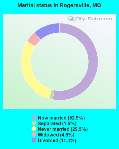
- Never married: 29.5%
- Now married: 52.9%
- Separated: 1.5%
- Widowed: 4.8%
- Divorced: 11.3%
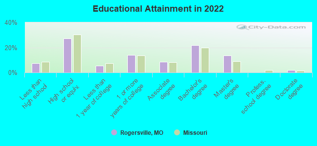
For population 25 years and over in Rogersville:
- High school or higher: 92.3%
- Bachelor's degree or higher: 36.2%
- Graduate or professional degree: 15.1%
- Unemployed: 6.0%
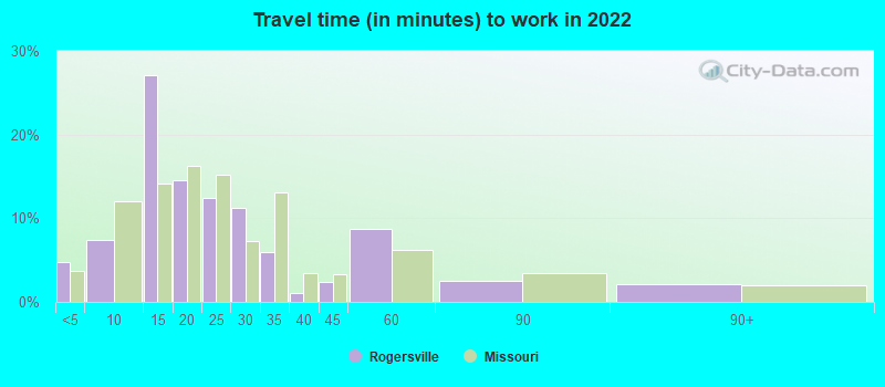
- Mean travel time to work (commute): 21.3 minutes
| Here: | 10.3 |
| Missouri average: | 11.1 |
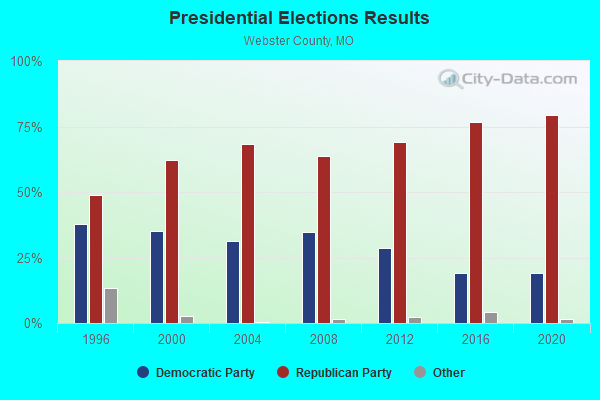
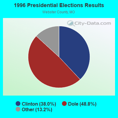
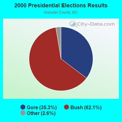
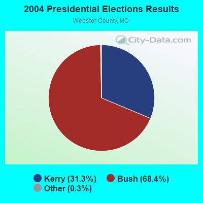
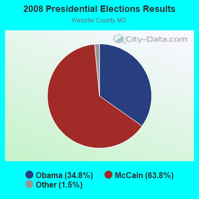

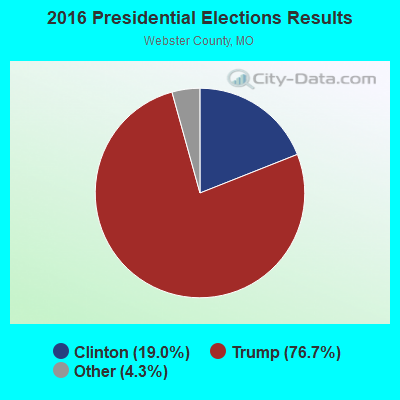
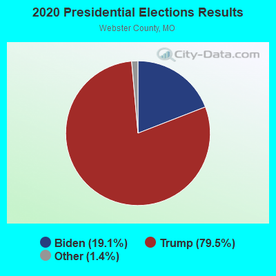
Graphs represent county-level data. Detailed 2008 Election Results
Religion statistics for Rogersville, MO (based on Webster County data)
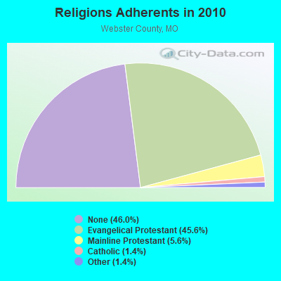
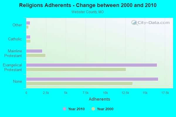
| Religion | Adherents | Congregations |
|---|---|---|
| Evangelical Protestant | 16,507 | 81 |
| Mainline Protestant | 2,035 | 13 |
| Catholic | 504 | 1 |
| Other | 491 | 1 |
| Orthodox | 2 | 1 |
| None | 16,663 | - |
Food Environment Statistics:
| Webster County: | 1.11 / 10,000 pop. |
| Missouri: | 1.88 / 10,000 pop. |
| This county: | 0.56 / 10,000 pop. |
| State: | 0.60 / 10,000 pop. |
| This county: | 5.85 / 10,000 pop. |
| Missouri: | 4.34 / 10,000 pop. |
| Webster County: | 3.90 / 10,000 pop. |
| State: | 7.37 / 10,000 pop. |
| This county: | 7.9% |
| Missouri: | 8.8% |
| Webster County: | 29.0% |
| Missouri: | 29.6% |
| This county: | 11.3% |
| Missouri: | 13.5% |
Health and Nutrition:
| This city: | 50.6% |
| State: | 50.9% |
| Here: | 48.7% |
| Missouri: | 48.6% |
| Here: | 28.8 |
| State: | 28.7 |
| Rogersville: | 20.9% |
| Missouri: | 20.6% |
| This city: | 10.2% |
| Missouri: | 10.1% |
| Here: | 6.9 |
| Missouri: | 6.8 |
| Rogersville: | 32.1% |
| Missouri: | 34.3% |
| Here: | 59.5% |
| State: | 57.5% |
| This city: | 80.1% |
| Missouri: | 79.3% |
More about Health and Nutrition of Rogersville, MO Residents
| Local government employment and payroll (March 2022) | |||||
| Function | Full-time employees | Monthly full-time payroll | Average yearly full-time wage | Part-time employees | Monthly part-time payroll |
|---|---|---|---|---|---|
| Police Protection - Officers | 11 | $40,578 | $44,267 | 0 | $0 |
| Water Supply | 3 | $12,356 | $49,424 | 0 | $0 |
| Other and Unallocable | 3 | $10,230 | $40,920 | 0 | $0 |
| Other Government Administration | 2 | $9,710 | $58,260 | 0 | $0 |
| Sewerage | 2 | $8,248 | $49,488 | 0 | $0 |
| Judicial and Legal | 1 | $3,259 | $39,108 | 0 | $0 |
| Streets and Highways | 1 | $3,454 | $41,448 | 0 | $0 |
| Parks and Recreation | 0 | $0 | 12 | $2,430 | |
| Totals for Government | 23 | $87,835 | $45,827 | 12 | $2,430 |
Rogersville government finances - Expenditure in 2017 (per resident):
- Construction - Regular Highways: $739,000 ($151.31)
Water Utilities: $74,000 ($15.15)
Police Protection: $25,000 ($5.12)
Parks and Recreation: $6,000 ($1.23)
Financial Administration: $4,000 ($0.82)
Sewerage: $2,000 ($0.41)
- Current Operations - Police Protection: $477,000 ($97.67)
Water Utilities: $454,000 ($92.96)
Sewerage: $454,000 ($92.96)
Solid Waste Management: $128,000 ($26.21)
Financial Administration: $123,000 ($25.18)
Central Staff Services: $121,000 ($24.77)
Regular Highways: $112,000 ($22.93)
Parks and Recreation: $74,000 ($15.15)
Protective Inspection and Regulation - Other: $33,000 ($6.76)
Judicial and Legal Services: $10,000 ($2.05)
- Total Salaries and Wages: $695,000 ($142.30)
- Water Utilities - Interest on Debt: $257,000 ($52.62)
Rogersville government finances - Revenue in 2017 (per resident):
- Charges - Sewerage: $510,000 ($104.42)
Solid Waste Management: $149,000 ($30.51)
Parks and Recreation: $46,000 ($9.42)
- Local Intergovernmental - Highways: $3,000 ($0.61)
- Miscellaneous - Fines and Forfeits: $50,000 ($10.24)
Interest Earnings: $14,000 ($2.87)
Rents: $8,000 ($1.64)
General Revenue - Other: $3,000 ($0.61)
Special Assessments: $1,000 ($0.20)
Sale of Property: $1,000 ($0.20)
- Revenue - Water Utilities: $510,000 ($104.42)
- State Intergovernmental - Highways: $123,000 ($25.18)
Sewerage: $38,000 ($7.78)
Water Utilities: $34,000 ($6.96)
Public Welfare: $22,000 ($4.50)
- Tax - General Sales and Gross Receipts: $751,000 ($153.77)
Property: $270,000 ($55.28)
Other License: $163,000 ($33.37)
Public Utilities Sales: $115,000 ($23.55)
Occupation and Business License - Other: $5,000 ($1.02)
Public Utility License: $4,000 ($0.82)
Alcoholic Beverage License: $3,000 ($0.61)
Rogersville government finances - Debt in 2017 (per resident):
- Long Term Debt - Beginning Outstanding - Unspecified Public Purpose: $6,417,000 ($1313.88)
Outstanding Unspecified Public Purpose: $6,303,000 ($1290.54)
Retired Unspecified Public Purpose: $113,000 ($23.14)
Rogersville government finances - Cash and Securities in 2017 (per resident):
- Other Funds - Cash and Securities: $1,409,000 ($288.49)
- Sinking Funds - Cash and Securities: $281,000 ($57.53)
| Businesses in Rogersville, MO | ||||
| Name | Count | Name | Count | |
|---|---|---|---|---|
| Curves | 1 | McDonald's | 1 | |
| H&R Block | 1 | Subway | 1 | |
| Hardee's | 1 | Taco Bell | 1 | |
| KFC | 1 | U-Haul | 1 | |
| MasterBrand Cabinets | 1 | UPS | 2 | |
Strongest AM radio stations in Rogersville:
- KWTO (560 AM; 5 kW; SPRINGFIELD, MO; Owner: KWTO, INC.)
- KMRF (1510 AM; daytime; 5 kW; MARSHFIELD, MO; Owner: NEW LIFE EVANGELISTIC CENTER, INC.)
- KLFJ (1550 AM; 5 kW; SPRINGFIELD, MO; Owner: 127, INC.)
- KSGF (1260 AM; 5 kW; SPRINGFIELD, MO; Owner: JOURNAL BROADCAST CORPORATION)
- KIDS (1340 AM; 1 kW; SPRINGFIELD, MO; Owner: THIRTEEN FORTY PRODUCTIONS INC.)
- KBNN (750 AM; daytime; 5 kW; LEBANON, MO; Owner: OZARK BROADCASTING, INC.)
- KGMY (1400 AM; 1 kW; SPRINGFIELD, MO; Owner: CLEAR CHANNEL BROADCASTING LICENSES, INC.)
- WHB (810 AM; 50 kW; KANSAS CITY, MO; Owner: UNION BROADCASTING, INC.)
- KTOZ (1060 AM; daytime; 0 kW; SPRINGFIELD, MO; Owner: THE ENTERTAINMENT NETWORK, INC.)
- KGHT (880 AM; 50 kW; SHERIDAN, AR; Owner: METROPOLITAN RADIO GROUP, INC.)
- KRMG (740 AM; 50 kW; TULSA, OK; Owner: CXR HOLDINGS, INC.)
- KRMS (1150 AM; 10 kW; OSAGE BEACH, MO; Owner: VIPER COMMUNICATIONS, INC)
- KFAQ (1170 AM; 50 kW; TULSA, OK; Owner: JOURNAL BROADCAST CORPORATION)
Strongest FM radio stations in Rogersville:
- KXUS (97.3 FM; SPRINGFIELD, MO; Owner: CLEAR CHANNEL BROADCASTING LICENSES, INC.)
- KTXR (101.3 FM; SPRINGFIELD, MO; Owner: STEREO BROADCASTING, INC.)
- KSPW (96.5 FM; SPARTA, MO; Owner: JOURNAL BROADCAST CORPORATION)
- KWFC (89.1 FM; SPRINGFIELD, MO; Owner: BAPTIST BIBLE COLLEGE, INC.)
- KWND (88.3 FM; SPRINGFIELD, MO; Owner: RADIO TRAINING NETWORK, INC)
- KTTS-FM (94.7 FM; SPRINGFIELD, MO; Owner: JOURNAL BROADCAST CORPORATION)
- KKLH (104.7 FM; MARSHFIELD, MO; Owner: MW SPRINGMO, INC.)
- KWTO-FM (98.7 FM; SPRINGFIELD, MO; Owner: KWTO, INC.)
- KSCV (90.1 FM; SPRINGFIELD, MO; Owner: COMMUNITY BROADCASTING, INC.)
- KSMU (91.1 FM; SPRINGFIELD, MO; Owner: BD OF REGENTS FOR SW MO ST UNIV)
- KJEL (103.7 FM; LEBANON, MO; Owner: OZARK BROADCASTING, INC.)
- KGMY-FM (100.5 FM; AURORA, MO; Owner: CLEAR CHANNEL BROADCASTING LICENSES, INC.)
- KRZK (106.3 FM; BRANSON, MO; Owner: TURTLE BROADCASTING CO. OF BRANSON)
- KGBX-FM (105.9 FM; NIXA, MO; Owner: CLEAR CHANNEL BROADCASTING LICENSES, INC.)
- KOMG (92.9 FM; OZARK, MO; Owner: MW SPRINGMO, INC.)
- KTOZ-FM (95.5 FM; PLEASANT HOPE, MO; Owner: CLEAR CHANNEL BROADCASTING LICENSES, INC.)
- KNLM (91.9 FM; MARSHFIELD, MO; Owner: NEW LIFE EVANGELISTIC CENTER, INC.)
- KADI (99.5 FM; REPUBLIC, MO; Owner: VISION COMMUNICATIONS, INCORPORATED)
- KBFL (99.9 FM; BUFFALO, MO; Owner: MEYER-BALDRIDGE, INC.)
- KOSP (105.1 FM; WILLARD, MO; Owner: MW SPRINGMO, INC.)
TV broadcast stations around Rogersville:
- KYTV (Channel 3; SPRINGFIELD, MO; Owner: KY3, INC.)
- KOZK (Channel 21; SPRINGFIELD, MO; Owner: BD. OF GOVERNORS OF SW MISSOURI STATE UNIVERSITY)
- KSPR (Channel 33; SPRINGFIELD, MO; Owner: PIEDMONT TELEVISION OF SPRINGFIELD LICENSE LLC)
- KOLR (Channel 10; SPRINGFIELD, MO; Owner: VHR SPRINGFIELD LICENSE, INC.)
- KDEB-TV (Channel 27; SPRINGFIELD, MO; Owner: QUORUM OF MISSOURI LICENSE, LLC)
- K41FQ (Channel 41; SPRINGFIELD, MO; Owner: TRINITY BROADCASTING NETWORK)
- KWBS-LP (Channel 56; SPRINGFIELD, MO; Owner: EQUITY BROADCASTING CORPORATION)
- K68EL (Channel 68; MARSHFIELD, MO; Owner: NEW LIFE EVANGELISTIC CENTER, INC.)
- K15CZ (Channel 15; SPRINGFIELD, MO; Owner: KY3, INC.)
- KWBM (Channel 31; HARRISON, AR; Owner: R.S. COMMUNICATIONS LTD. PARTNERSHIP)
- K08MA (Channel 8; SPRINGFIELD, MO; Owner: METROPOLITAN RADIO GROUP, INC.)
- K49DG (Channel 49; SPRINGFIELD, MO; Owner: TRINITY BROADCASTING NETWORK)
- K54FX (Channel 54; SPRINGFIELD, MO; Owner: NEW LIFE EVANGELISTIC CENTER, INC.)
- KBNS-CA (Channel 38; BRANSON, MO; Owner: THE VACATION CHANNEL, INC.)
- Rogersville, Missouri
- Fatal accident count12
- Vehicles involved in fatal accidents22
- Fatal accidents involving drunk persons:3
- Fatalities14
- Persons involved in fatal accidents36
- Pedestrians involved in fatal accidents0
- Missouri average
- Fatal accident count8913
- Vehicles involved in fatal accidents13556
- Fatal accidents involving drunk persons2668
- Fatalities9945
- Persons involved in fatal accidents21728
- Pedestrians involved in fatal accidents802
- National Bridge Inventory (NBI) Statistics
- 34Number of bridges
- 279ft / 85.2mTotal length
- $1,171,000Total costs
- 100,806Total average daily traffic
- 17,973Total average daily truck traffic
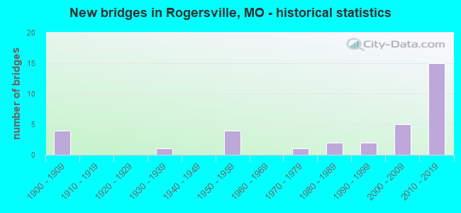
- New bridges - historical statistics
- 41900-1909
- 11930-1939
- 41950-1959
- 11970-1979
- 21980-1989
- 21990-1999
- 52000-2009
- 152010-2019
FCC Registered Cell Phone Towers:
4 (See the full list of FCC Registered Cell Phone Towers in Rogersville)FCC Registered Antenna Towers:
71 (See the full list of FCC Registered Antenna Towers)FCC Registered Private Land Mobile Towers:
1- Us Hwy 60 3 Km E (Lat: 37.117556 Lon: -93.013778), Type: Tower, Structure height: 92 m, Call Sign: WPHB598,
Assigned Frequencies: 929.012 MHz, Grant Date: 03/25/1996, Expiration Date: 03/25/2001, Cancellation Date: 01/31/2001, Certifier: Kenneth Goldstein, Registrant: Fiorio Communications Consulting, 10451 Twin Rivers Rd Ste 207, Columbia, MD 21044-2333, Fax: (301) 596-1121
FCC Registered Broadcast Land Mobile Towers:
6- Lat: 37.113111 Lon: -93.056000, Call Sign: WNWS838,
Assigned Frequencies: 451.337 MHz, 451.762 MHz, 456.612 MHz, 456.362 MHz, 457.512 MHz, Grant Date: 04/13/2021, Expiration Date: 07/09/2031, Registrant: Logan-Rogersville R-8 School District, 100 E. Front St., Rogesville, MO 65742, Phone: (417) 753-2891, Fax: (417) 887-1434, Email:
- 159 Endeavor Dr (Lat: 37.115278 Lon: -93.035722), Type: Bant, Structure height: 6.1 m, Overall height: 12.2 m, Call Sign: WQIP264,
Assigned Frequencies: 463.362 MHz, 452.600 MHz, Grant Date: 03/27/2018, Expiration Date: 04/02/2028, Certifier: Michelle Williams, Registrant: Rayfield Communications, Inc, 2018 W. Woodland, Springfield, MO 65807, Phone: (417) 887-4663, Fax: (417) 887-1434, Email:
- ROGERSVILLE HLCS HBD, Bnsf Ls1001 Mp 215.8 Rogersville Hlcs Hbd (Lat: 37.146278 Lon: -93.101111), Type: Building, Structure height: 3.4 m, Overall height: 7.3 m, Call Sign: WQIY951,
Assigned Frequencies: 44.5800 MHz, Grant Date: 04/05/2018, Expiration Date: 06/25/2028, Certifier: Robert Leedham, Registrant: Bnsf Railway Co., 4515 Kansas Ave, Kansas City, KS 66106, Phone: (913) 551-4015, Fax: (913) 551-4053, Email:
- Lat: 37.140000 Lon: -93.176111, Call Sign: WQNT694,
Assigned Frequencies: 456.562 MHz, 457.400 MHz, 456.537 MHz, 457.412 MHz, 457.812 MHz, Grant Date: 05/20/2011, Expiration Date: 05/20/2021, Cancellation Date: 07/24/2021, Certifier: Josh Metsker, Registrant: Radiophone Engineering, Inc., 534 West Walnut, Springfield, MO 65806, Phone: (417) 862-6653, Fax: (417) 862-6768, Email:
- ROGERSVILLE S. WIU, Bnsf Ls1001 Mp 219.1 Rogersville S. Wiu (Lat: 37.118000 Lon: -93.057278), Type: Building, Structure height: 4.6 m, Overall height: 7 m, Call Sign: WQTB946,
Assigned Frequencies: 160.965 MHz, Grant Date: 10/17/2023, Expiration Date: 12/31/2033, Certifier: Michael Murphy, Registrant: Bnsf Railway Co., 4515 Kansas Ave, Kansas City, KS 66106, Phone: (913) 551-4015, Email:
- Warren Ave (Lat: 37.113083 Lon: -93.052528), Type: Tank, Structure height: 39.6 m, Overall height: 42.7 m, Call Sign: WRCH978,
Assigned Frequencies: 451.381 MHz, Grant Date: 10/06/2018, Expiration Date: 10/06/2028, Certifier: Charlie Montelongo, Registrant: Master Meter Inc., 101 Regency Parkway, Mansfield, TX 76063-5093, Phone: (817) 842-8000, Fax: (817) 842-8030, Email:
FCC Registered Microwave Towers:
8 (See the full list of FCC Registered Microwave Towers in this town)FCC Registered Amateur Radio Licenses:
80 (See the full list of FCC Registered Amateur Radio Licenses in Rogersville)FAA Registered Aircraft Manufacturers and Dealers:
1 (See the full list of FAA Registered Manufacturers and Dealers in Rogersville)FAA Registered Aircraft:
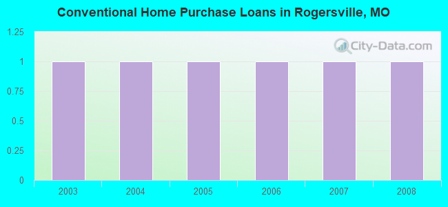
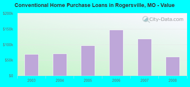
10 (See the full list of FAA Registered Aircraft)| Home Mortgage Disclosure Act Aggregated Statistics For Year 2009 (Based on 1 partial tract) | ||
| C) Refinancings | ||
|---|---|---|
| Number | Average Value | |
| LOANS ORIGINATED | 2 | $128,245 |
| APPLICATIONS APPROVED, NOT ACCEPTED | 0 | $0 |
| APPLICATIONS DENIED | 1 | $80,560 |
| APPLICATIONS WITHDRAWN | 0 | $0 |
| FILES CLOSED FOR INCOMPLETENESS | 0 | $0 |
Detailed HMDA statistics for the following Tracts: 9703.00
2002 - 2018 National Fire Incident Reporting System (NFIRS) incidents
- Fire incident types reported to NFIRS in Rogersville, MO
- 53846.6%Structure Fires
- 47341.0%Outside Fires
- 1119.6%Mobile Property/Vehicle Fires
- 322.8%Other
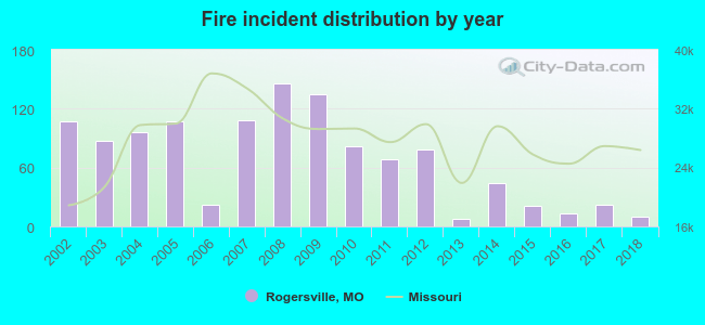 According to the data from the years 2002 - 2018 the average number of fire incidents per year is 68. The highest number of fires - 146 took place in 2008, and the least - 8 in 2013. The data has a dropping trend.
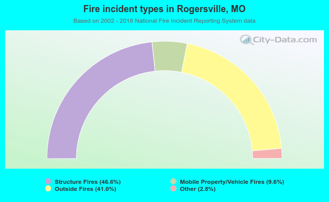 When looking into fire subcategories, the most incidents belonged to: Structure Fires (46.6%), and Outside Fires (41.0%).
| Most common first names in Rogersville, MO among deceased individuals | ||
| Name | Count | Lived (average) |
|---|---|---|
| William | 41 | 74.2 years |
| John | 37 | 77.0 years |
| Mary | 35 | 81.0 years |
| Robert | 31 | 71.9 years |
| James | 28 | 76.4 years |
| George | 22 | 75.7 years |
| Charles | 20 | 70.7 years |
| Ruth | 15 | 77.2 years |
| Joe | 15 | 68.6 years |
| Paul | 14 | 76.9 years |
| Most common last names in Rogersville, MO among deceased individuals | ||
| Last name | Count | Lived (average) |
|---|---|---|
| Smith | 30 | 74.8 years |
| Williams | 18 | 77.4 years |
| Miller | 14 | 81.6 years |
| Davis | 14 | 77.5 years |
| Johnson | 13 | 81.4 years |
| Scott | 13 | 80.3 years |
| Moore | 12 | 73.6 years |
| Watts | 10 | 77.1 years |
| Barnard | 10 | 80.5 years |
| Swearengin | 9 | 80.2 years |
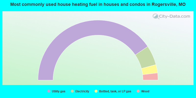
- 81.0%Utility gas
- 10.6%Electricity
- 4.5%Bottled, tank, or LP gas
- 3.8%Wood
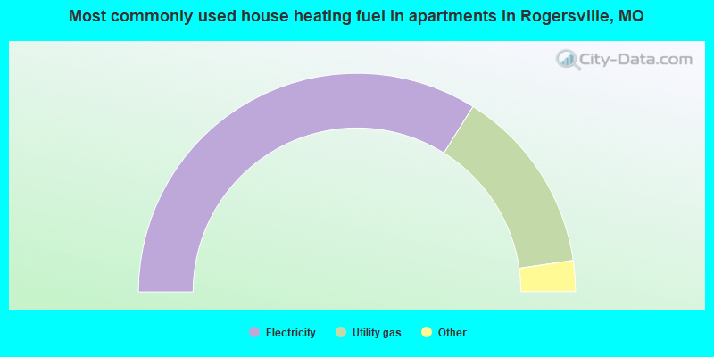
- 67.9%Electricity
- 27.6%Utility gas
- 3.8%Bottled, tank, or LP gas
- 0.7%No fuel used
Rogersville compared to Missouri state average:
- Unemployed percentage below state average.
- Black race population percentage significantly below state average.
- Hispanic race population percentage significantly below state average.
- Median age below state average.
- Foreign-born population percentage significantly below state average.
- Length of stay since moving in below state average.
- House age below state average.
- Percentage of population with a bachelor's degree or higher above state average.

|
|
Total of 25 patent applications in 2008-2024.