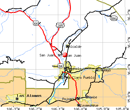
San Juan, New Mexico
Submit your own pictures of this place and show them to the world
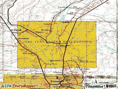
- OSM Map
- General Map
- Google Map
- MSN Map
| Males: 271 | |
| Females: 314 |
| Median resident age: | 31.8 years |
| New Mexico median age: | 34.6 years |
Zip codes: 87566.
| San Juan: | $47,954 |
| NM: | $59,726 |
Estimated per capita income in 2022: $21,446 (it was $10,568 in 2000)
San Juan CDP income, earnings, and wages data
Estimated median house or condo value in 2022: $142,659 (it was $52,800 in 2000)
| San Juan: | $142,659 |
| NM: | $243,100 |
Detailed information about poverty and poor residents in San Juan, NM


- 40768.8%American Indian alone
- 16027.0%Hispanic
- 122.0%White alone
- 101.7%Two or more races
- 20.3%Black alone
- 10.2%Asian alone
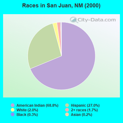
Races in San Juan detailed stats: ancestries, foreign born residents, place of birth
According to our research of New Mexico and other state lists, there was 1 registered sex offender living in San Juan, New Mexico as of May 08, 2024.
The ratio of all residents to sex offenders in San Juan is 585 to 1.
 Recent articles from our blog. Our writers, many of them Ph.D. graduates or candidates, create easy-to-read articles on a wide variety of topics.

 | Is New Mexico (and the southwest in general) not viable anymore because of water? (31 replies) |
| San Juan River best place to live nearby (0 replies) |
| New Mexico Covid-19 discussion (429 replies) |
| Carson NF outdoor recreation (1 reply) |
| Is there a pueblo where one can see real old-way lifestyle of the locals? (60 replies) |
| Shiprock, NM...info please (13 replies) |
Latest news from San Juan, NM collected exclusively by city-data.com from local newspapers, TV, and radio stations
Current Local Time: MST time zone
Land area: 0.57 square miles.
Population density: 1,024 people per square mile (low).
3 residents are foreign born
| This place: | 0.5% |
| New Mexico: | 8.2% |
| San Juan CDP: | 0.6% ($343) |
| New Mexico: | 0.7% ($699) |
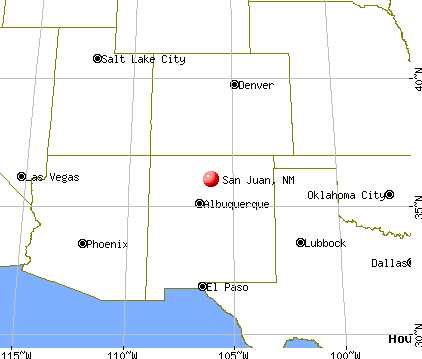
Nearest city with pop. 50,000+: Santa Fe, NM  (27.3 miles , pop. 62,203).
Nearest city with pop. 200,000+: Albuquerque, NM (71.9 miles , pop. 448,607).
Nearest city with pop. 1,000,000+: Phoenix, AZ (383.2 miles , pop. 1,321,045).
Nearest cities:
), ), ), ), ), )Latitude: 36.05 N, Longitude: 106.07 W
| Here: | 3.3% |
| New Mexico: | 3.6% |
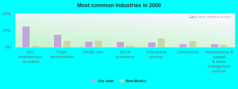
- Arts, entertainment, recreation (25.2%)
- Public administration (15.3%)
- Health care (7.2%)
- Social assistance (6.8%)
- Educational services (5.9%)
- Construction (4.1%)
- Administrative & support & waste management services (4.1%)
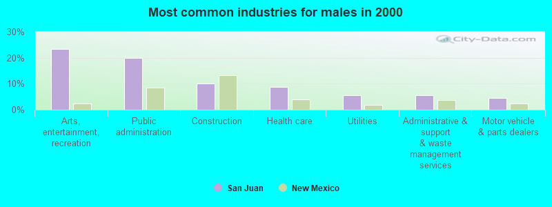
- Arts, entertainment, recreation (23.3%)
- Public administration (20.0%)
- Construction (10.0%)
- Health care (8.9%)
- Utilities (5.6%)
- Administrative & support & waste management services (5.6%)
- Motor vehicle & parts dealers (4.4%)
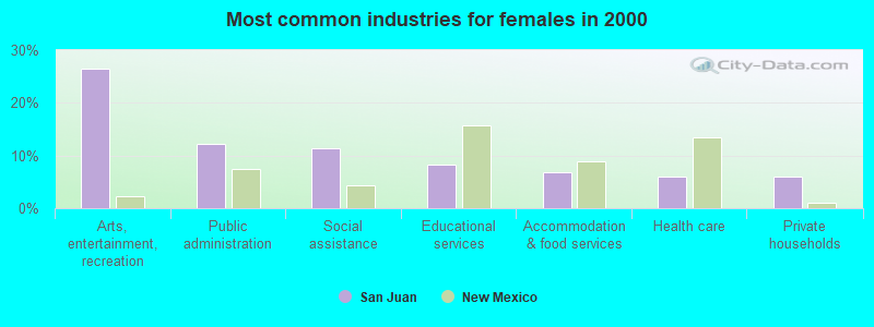
- Arts, entertainment, recreation (26.5%)
- Public administration (12.1%)
- Social assistance (11.4%)
- Educational services (8.3%)
- Accommodation & food services (6.8%)
- Health care (6.1%)
- Private households (6.1%)
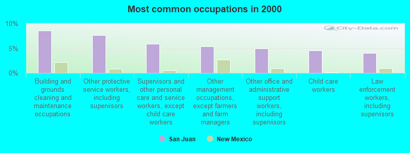
- Building and grounds cleaning and maintenance occupations (8.6%)
- Other protective service workers, including supervisors (7.7%)
- Supervisors and other personal care and service workers, except child care workers (5.9%)
- Other management occupations, except farmers and farm managers (5.4%)
- Other office and administrative support workers, including supervisors (5.0%)
- Child care workers (4.5%)
- Law enforcement workers, including supervisors (4.1%)
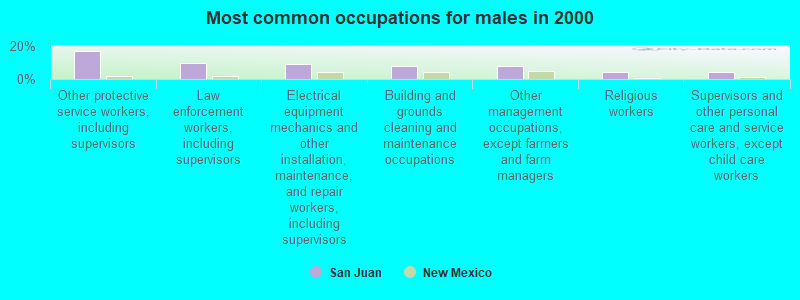
- Other protective service workers, including supervisors (16.7%)
- Law enforcement workers, including supervisors (10.0%)
- Electrical equipment mechanics and other installation, maintenance, and repair workers, including supervisors (8.9%)
- Building and grounds cleaning and maintenance occupations (7.8%)
- Other management occupations, except farmers and farm managers (7.8%)
- Religious workers (4.4%)
- Supervisors and other personal care and service workers, except child care workers (4.4%)
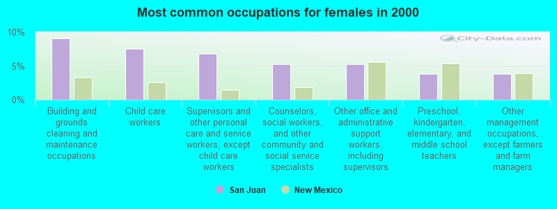
- Building and grounds cleaning and maintenance occupations (9.1%)
- Child care workers (7.6%)
- Supervisors and other personal care and service workers, except child care workers (6.8%)
- Counselors, social workers, and other community and social service specialists (5.3%)
- Other office and administrative support workers, including supervisors (5.3%)
- Preschool, kindergarten, elementary, and middle school teachers (3.8%)
- Other management occupations, except farmers and farm managers (3.8%)
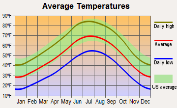
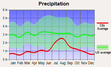
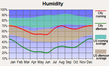
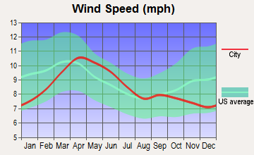
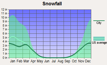
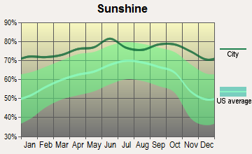
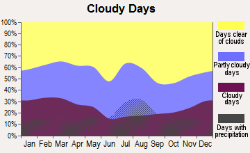
Average climate in San Juan, New Mexico
Based on data reported by over 4,000 weather stations
Earthquake activity:
San Juan-area historical earthquake activity is significantly above New Mexico state average. It is 782% greater than the overall U.S. average.On 8/23/2011 at 05:46:18, a magnitude 5.3 (5.3 MW, Depth: 2.5 mi, Class: Moderate, Intensity: VI - VII) earthquake occurred 103.2 miles away from the city center
On 8/10/2005 at 22:08:22, a magnitude 5.0 (5.0 MW, Depth: 3.1 mi) earthquake occurred 92.4 miles away from San Juan center
On 8/10/2005 at 22:08:22, a magnitude 5.0 (5.0 MB, 4.7 MS, 5.0 MW) earthquake occurred 94.0 miles away from San Juan center
On 6/28/1992 at 11:57:34, a magnitude 7.6 (6.2 MB, 7.6 MS, 7.3 MW, Depth: 0.7 mi, Class: Major, Intensity: VIII - XII) earthquake occurred 605.6 miles away from San Juan center, causing 3 deaths (1 shaking deaths, 2 other deaths) and 400 injuries, causing $100,000,000 total damage and $40,000,000 insured losses
On 1/29/1990 at 13:16:10, a magnitude 4.8 (4.5 MB, 4.8 LG, Depth: 7.5 mi, Class: Light, Intensity: IV - V) earthquake occurred 119.1 miles away from the city center
On 8/22/2011 at 23:30:19, a magnitude 4.7 (4.7 MW, Depth: 3.1 mi) earthquake occurred 108.0 miles away from San Juan center
Magnitude types: regional Lg-wave magnitude (LG), body-wave magnitude (MB), surface-wave magnitude (MS), moment magnitude (MW)
Natural disasters:
The number of natural disasters in Rio Arriba County (13) is near the US average (15).Major Disasters (Presidential) Declared: 7
Emergencies Declared: 3
Causes of natural disasters: Floods: 5, Storms: 5, Fires: 4, Snows: 2, Drought: 1, Hurricane: 1, Mudslide: 1, Winter Storm: 1, Other: 1 (Note: some incidents may be assigned to more than one category).
Colleges/universities with over 2000 students nearest to San Juan:
- Santa Fe Community College (about 33 miles; Santa Fe, NM; Full-time enrollment: 3,047)
- New Mexico Highlands University (about 57 miles; Las Vegas, NM; FT enrollment: 2,931)
- University of Phoenix-Albuquerque Campus (about 66 miles; Albuquerque, NM; FT enrollment: 2,335)
- University of New Mexico-Main Campus (about 74 miles; Albuquerque, NM; FT enrollment: 23,042)
- Central New Mexico Community College (about 75 miles; Albuquerque, NM; FT enrollment: 19,398)
- Adams State University (about 100 miles; Alamosa, CO; FT enrollment: 2,805)
- San Juan College (about 127 miles; Farmington, NM; FT enrollment: 5,112)
Points of interest:
Notable location: San Juan Pueblo Community Library (A). Display/hide its location on the map
Parks in San Juan include: Pueblo of San Juan Historical Marker (1), San Gabriel on the Camino Real Historical Marker (2). Display/hide their locations on the map
| This place: | 3.1 people |
| New Mexico: | 2.6 people |
| This place: | 78.8% |
| Whole state: | 69.2% |
| This place: | 14.5% |
| Whole state: | 6.4% |
Likely homosexual households (counted as self-reported same-sex unmarried-partner households)
- Lesbian couples: 0.0% of all households
- Gay men: 0.5% of all households
| This place: | 25.6% |
| Whole state: | 18.4% |
| This place: | 13.9% |
| Whole state: | 7.8% |
For population 15 years and over in San Juan:
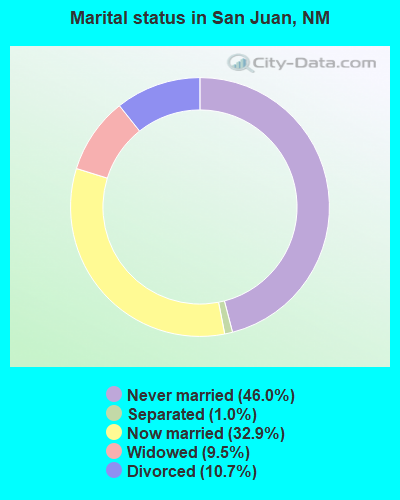
- Never married: 46.0%
- Now married: 32.9%
- Separated: 1.0%
- Widowed: 9.5%
- Divorced: 10.7%
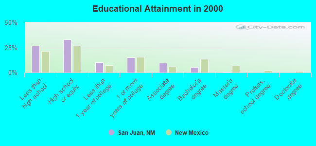
For population 25 years and over in San Juan:
- High school or higher: 73.4%
- Bachelor's degree or higher: 5.5%
- Graduate or professional degree: 0.3%
- Unemployed: 11.9%
- Mean travel time to work (commute): 21.4 minutes
| Here: | 10.1 |
| New Mexico average: | 14.5 |
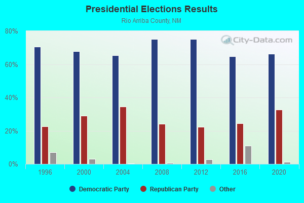
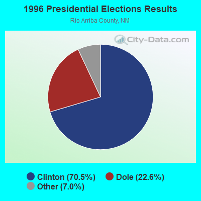
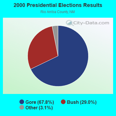
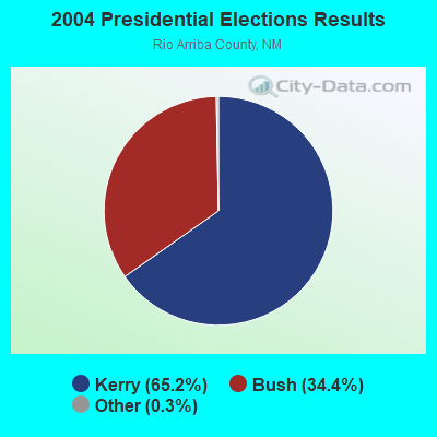
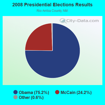
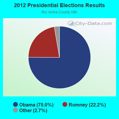
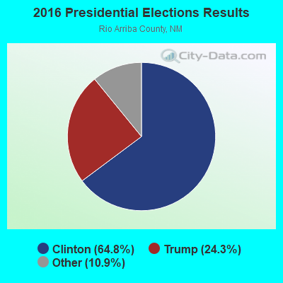
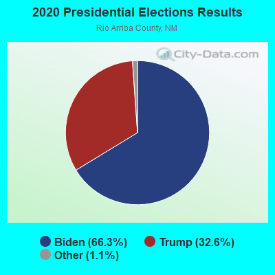
Graphs represent county-level data. Detailed 2008 Election Results
Religion statistics for San Juan, NM (based on Rio Arriba County data)
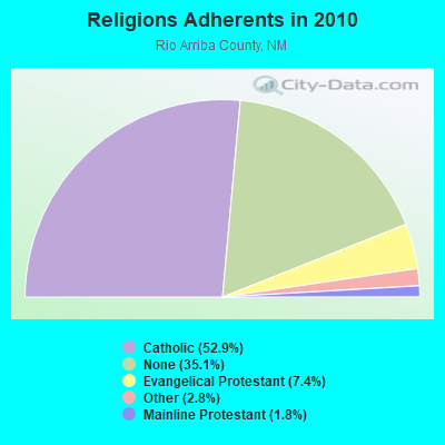
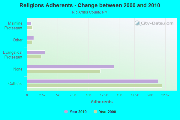
| Religion | Adherents | Congregations |
|---|---|---|
| Catholic | 21,305 | 41 |
| Evangelical Protestant | 2,960 | 29 |
| Other | 1,114 | 6 |
| Mainline Protestant | 722 | 9 |
| Orthodox | 5 | 1 |
| None | 14,140 | - |
Food Environment Statistics:
| This county: | 1.72 / 10,000 pop. |
| New Mexico: | 1.44 / 10,000 pop. |
| Rio Arriba County: | 0.25 / 10,000 pop. |
| New Mexico: | 0.21 / 10,000 pop. |
| Rio Arriba County: | 0.74 / 10,000 pop. |
| New Mexico: | 0.32 / 10,000 pop. |
| Rio Arriba County: | 5.16 / 10,000 pop. |
| New Mexico: | 4.06 / 10,000 pop. |
| This county: | 5.65 / 10,000 pop. |
| New Mexico: | 7.12 / 10,000 pop. |
| Rio Arriba County: | 5.9% |
| State: | 6.4% |
| This county: | 21.0% |
| State: | 22.1% |
Strongest AM radio stations in San Juan:
- KDCE (950 AM; 4 kW; ESPANOLA, NM; Owner: RICHARD L. GARCIA BROADCASTING, INC.)
- KKOB (770 AM; 50 kW; ALBUQUERQUE, NM; Owner: CITADEL BROADCASTING COMPANY)
- KSWV (810 AM; 5 kW; SANTA FE, NM; Owner: LA VOZ BROADCASTING CO., INC.)
- KTRC (1260 AM; 5 kW; SANTA FE, NM; Owner: AGM NEVADA, LLC)
- KRSN (1490 AM; 1 kW; LOS ALAMOS, NM; Owner: REAL RADIO, L.L.C.)
- KTNN (660 AM; 50 kW; WINDOW ROCK, AZ; Owner: THE NAVAJO NATION)
- KNMX (540 AM; 5 kW; LAS VEGAS, NM; Owner: SANGRE DE CRISTO B/DCASTING CO, INC)
- KKIM (1000 AM; 10 kW; ALBUQUERQUE, NM; Owner: AGM-NEVADA, LLC)
- KHAC (880 AM; 43 kW; TSE BONITO, NM; Owner: WESTERN INDIAN MINISTRIES, INC.)
- KXKS (1190 AM; 10 kW; ALBUQUERQUE, NM; Owner: CLEAR CHANNEL BROADCASTING LICENSES, INC.)
- KANM (1600 AM; 10 kW; ALBUQUERQUE, NM; Owner: ARAGON BROADCASTING COMPANY, L.L.C.)
- KICA (980 AM; 50 kW; CLOVIS, NM; Owner: BROADCAST ENTERTAINMENT CORPORATION)
- KNML (610 AM; 5 kW; ALBUQUERQUE, NM; Owner: CITADEL BROADCASTING COMPANY)
Strongest FM radio stations in San Juan:
- KBOM (94.7 FM; SANTA FE, NM; Owner: AGM NEVADA, LLC)
- KQBA (107.5 FM; LOS ALAMOS, NM; Owner: HUTTON MEDIA, L.L.C.)
- KSFQ (101.1 FM; WHITE ROCK, NM; Owner: CLEAR CHANNEL BROADCASTING LICENSES, INC.)
- KZNM (106.7 FM; LOS ALAMOS, NM; Owner: AGM NEVADA, LLC)
- KTAO (101.9 FM; TAOS, NM; Owner: TAOS COMMUNICATIONS CORPORATION)
- KAJZ (105.1 FM; SANTA FE, NM; Owner: HBC LICENSE CORPORATION)
- KRZY-FM (105.9 FM; SANTA FE, NM; Owner: ENTRAVISION HOLDINGS, LLC)
- KABG (98.5 FM; LOS ALAMOS, NM; Owner: AGM-NEVADA, L.L.C.)
- KBAC (104.1 FM; SANTA FE, NM; Owner: CITICASTERS LICENSES, L.P.)
- KKSS (97.3 FM; SANTA FE, NM; Owner: HBC LICENSE CORPORATION)
- KHFM (95.5 FM; SANTA FE, NM; Owner: AGM-NEVADA L.L.C)
- KYBR (92.9 FM; ESPANOLA, NM; Owner: RIO CHAMA BROADCASTING COMPANY)
- KTZO (103.3 FM; ALBUQUERQUE, NM; Owner: CITADEL BROADCASTING COMPANY)
- KLYT (88.3 FM; ALBUQUERQUE, NM; Owner: CONNECTION COMMUNICATIONS ASSOCIATION, INC.)
- KRST (92.3 FM; ALBUQUERQUE, NM; Owner: CITADEL BROADCASTING COMPANY)
- KUNM (89.9 FM; ALBUQUERQUE, NM; Owner: BOARD OF REGENTS UNIV. OF NEW MEXICO)
- KANW (89.1 FM; ALBUQUERQUE, NM; Owner: BD. OF EDUC. CITY OF ALBUQUERQUE, NM)
- KKOB-FM (93.3 FM; ALBUQUERQUE, NM; Owner: CITADEL BROADCASTING COMPANY)
- KBZU (96.3 FM; ALBUQUERQUE, NM; Owner: CITADEL BROADCASTING COMPANY)
- KMGA (99.5 FM; ALBUQUERQUE, NM; Owner: CITADEL BROADCASTING COMPANY)
San Juan fatal accident list:
Nov 17, 2002 00:40 AM, Sr-74, Lat: 36.055185, Lon: -106.072459, Vehicles: 1, Persons: 1, Fatalities: 1, Drunk persons involved: 1
FCC Registered Antenna Towers:
4- Lisa M Minney, Hwy 44 Thriftway 44 Country Store 1-23 & Road 44 (Lat: 36.242833 Lon: -107.704194), Type: 78.6, Overall height: 76.2 m, Registrant: Crown Atlantic Company, LLC, Regulatory.Department@crowncastle.Com, , Canon-sburg, Phone: (724) 416-2000
- Lisa M Minney, Section 7e 1/2 Ne 1/4,N 1/2 Se 1/4 Bernallilo & Road 44 (Lat: 36.499917 Lon: -107.937222), Type: 78.6, Overall height: 76.2 m, Registrant: Crown Atlantic Company, LLC, Regulatory.Deaprtment@crowncastle.Com, , Canon-sburg, Phone: (724) 416-2000
- David L McCann, Hwy 44 Thriftway 44 Country Store 1-23 & Road 44 (Lat: 36.242833 Lon: -107.704194), Type: 78.6, Overall height: 76.2 m, Registrant: Crown Atlantic Company, LLC, Regulatory.Department@crowncastle.Com, , Canon-sburg, Phone: (724) 416-2000
- David L McCann, Section 7e 1/2 Ne 1/4,N 1/2 Se 1/4 Bernallilo & Road 44 (Lat: 36.499917 Lon: -107.937222), Type: 78.6, Overall height: 76.2 m, Registrant: Crown Atlantic Company, LLC, Regulatory.Deaprtment@crowncastle.Com, , Canon-sburg, Phone: (724) 416-2000
FCC Registered Broadcast Land Mobile Towers:
1- Lat: 36.589444 Lon: -108.061667, Call Sign: WPUJ491,
Assigned Frequencies: 463.525 MHz, Grant Date: 03/15/2002, Expiration Date: 03/15/2012, Cancellation Date: 05/19/2012, Certifier: Vickie Mariano, Registrant: Lindsay Manufacturing Co, Lindsay, NE 68644, Phone: (402) 428-7231, Fax: (402) 428-7341, Email:
FCC Registered Microwave Towers:
3- Int Of Cr 1768 And Hwy 511 (Lat: 36.850278 Lon: -107.623361), Structure height: 10.7 m, Overall height: 11.6 m, Call Sign: WPNI939,
Assigned Frequencies: 957.150 MHz, Grant Date: 01/29/2003, Expiration Date: 01/29/2013, Cancellation Date: 04/08/2013, Phone: (505) 327-9624
- VCN/Navajo Bisti Nor, 1 Aps Access Road (Lat: 36.687833 Lon: -108.469639), Type: Gtower, Structure height: 18.3 m, Call Sign: WRQB956,
Assigned Frequencies: 11155.0 MHz, 11155.0 MHz, 11155.0 MHz, 11155.0 MHz, 11155.0 MHz, 11155.0 MHz, 11155.0 MHz, 11155.0 MHz, 11155.0 MHz, 11155.0 MHz... (+12 more), Grant Date: 04/19/2022, Expiration Date: 04/19/2032, Certifier: Preston Schilling, Registrant: Micronet Communications, Inc., 812 Lexington Dr, Plano, TX 75075, Phone: (972) 422-7200, Email:
- Mount Huerfano (Lat: 36.415000 Lon: -107.844778), Overall height: 44.2 m, Call Sign: WLD210,
Assigned Frequencies: 2059.00 MHz, Grant Date: 12/18/1989, Expiration Date: 04/01/2006, Cancellation Date: 10/18/2004, Registrant: Southwest Colorado Tv Translator Association, Cortez, CO 81321, Phone: (970) 565-2121, Email:
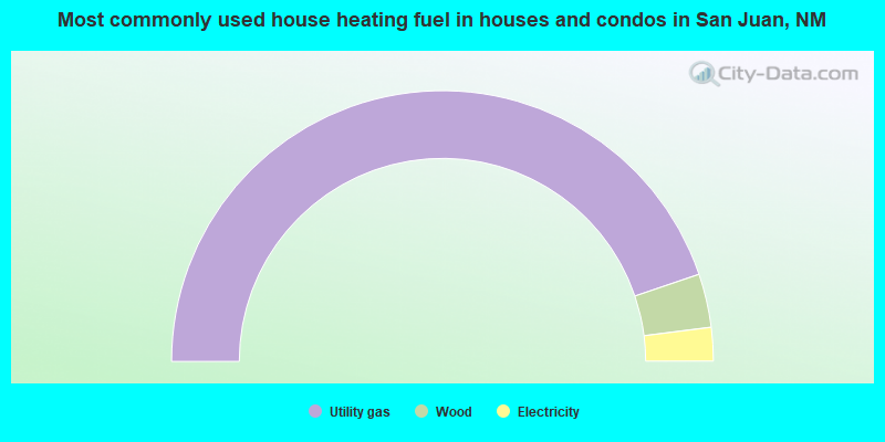
- 89.6%Utility gas
- 6.4%Wood
- 4.0%Electricity
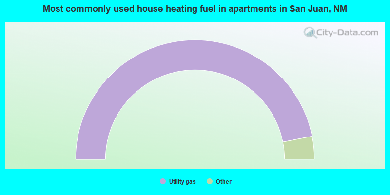
- 93.8%Utility gas
- 3.1%Wood
- 3.1%No fuel used
San Juan compared to New Mexico state average:
- Median house value below state average.
- Black race population percentage significantly below state average.
- Hispanic race population percentage below state average.
- Median age below state average.
- Foreign-born population percentage significantly below state average.
- Renting percentage significantly below state average.
- Length of stay since moving in significantly above state average.
- Number of rooms per house significantly below state average.
- House age significantly below state average.
- Number of college students below state average.
- Percentage of population with a bachelor's degree or higher significantly below state average.