South Kingstown, Rhode Island
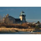
South Kingstown: Snug Harbor lighthouse
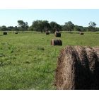
South Kingstown: Matunuck
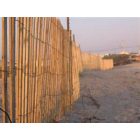
South Kingstown: Matunuck Beach Rd
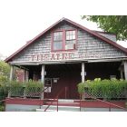
South Kingstown: Theatre by the Sea
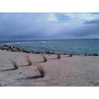
South Kingstown: South Kingstown Town Beach winter
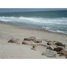
South Kingstown: East Matunuck
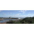
South Kingstown: Coast in SK
- add
your
Submit your own pictures of this town and show them to the world
- OSM Map
- Google Map
- MSN Map
Population change since 2000: +9.7%
 |
| Males: 14,557 | |
| Females: 16,082 |
| Median resident age: | 35.7 years |
| Rhode Island median age: | 42.3 years |
Zip codes: 02879.
| South Kingstown: | $106,554 |
| RI: | $81,854 |
Estimated per capita income in 2022: $48,937 (it was $23,827 in 2000)
South Kingstown town income, earnings, and wages data
Estimated median house or condo value in 2022: $537,245 (it was $171,100 in 2000)
| South Kingstown: | $537,245 |
| RI: | $383,900 |
Mean prices in 2022: all housing units: $576,051; detached houses: $602,530; townhouses or other attached units: $477,043; in 2-unit structures: $442,161; in 3-to-4-unit structures: $386,238; in 5-or-more-unit structures: $205,983; mobile homes: $109,666; occupied boats, rvs, vans, etc.: over $1,000,000
South Kingstown, RI residents, houses, and apartments details
Detailed information about poverty and poor residents in South Kingstown, RI


Compare current foreclosures near South Kingstown, RI:
| Photo | Address | Area | Beds / Baths | Price | Details |
|---|---|---|---|---|---|

|
#1
Hallville Rd
Exeter, RI 02822
|
943 sq. feet
|
1 baths 2 beds |
$69,900
|
show details |

|
#2
Sherman St
Newport, RI 02840
|
1,368 sq. feet
|
1 baths 3 beds |
show details | |

|
#3
Liberty St
Pawcatuck, CT 06379
|
1,880 sq. feet
|
2 baths 4 beds |
show details | |

|
#4
Tomaquag Rd
Ashaway, RI 02804
|
2,368 sq. feet
|
2 baths 4 beds |
show details | |

|
#5
A South County Trail
East Greenwich, RI 02818
|
1,748 sq. feet
|
1 baths 2 beds |
show details | |

|
#6
Red Oak Dr
Wyoming, RI 02898
|
1,132 sq. feet
|
1 baths 3 beds |
show details | |

|
#7
Crestwood Dr
Hope Valley, RI 02832
|
1,320 sq. feet
|
2 baths 3 beds |
show details | |

|
#8
Coventry Dr
Coventry, RI 02816
|
1,560 sq. feet
|
1 baths 3 beds |
show details | |

|
#9
Exchange Rd
West Warwick, RI 02893
|
1,976 sq. feet
|
1 baths 3 beds |
show details | |

|
#10
E Greenwich Ave
West Warwick, RI 02893
|
2,496 sq. feet
|
2 baths 4 beds |
show details |
| Photo | Address | Area | Beds / Baths | Price | Details |
|---|---|---|---|---|---|

|
#11
Longfellow Dr
Coventry, RI 02816
|
1,318 sq. feet
|
1 baths 3 beds |
show details | |

|
#12
Howland Rd
East Greenwich, RI 02818
|
2,642 sq. feet
|
2 baths 2 beds |
show details | |

|
#13
Clarks Falls Rd
North Stonington, CT 06359
|
1,638 sq. feet
|
2 baths 4 beds |
show details | |

|
#14
E Greenwich Ave
West Warwick, RI 02893
|
1,998 sq. feet
|
2 baths 3 beds |
show details | |

|
#15
Sachuest Way
Middletown, RI 02842
|
1,640 sq. feet
|
1 baths 4 beds |
show details | |

|
#16
Samson Ln
Middletown, RI 02842
|
2,626 sq. feet
|
3 baths 3 beds |
show details | |

|
#17
Clemente Dr
East Greenwich, RI 02818
|
1,170 sq. feet
|
1 baths 3 beds |
show details | |

|
#18
Fletcher Rd
North Kingstown, RI 02852
|
2,226 sq. feet
|
2 baths 4 beds |
show details | |

|
#19
Dinonsie Way
Wakefield, RI 02879
|
2,048 sq. feet
|
2 baths 3 beds |
show details | |

|
#20
Top St
Westerly, RI 02891
|
1,118 sq. feet
|
1 baths 3 beds |
show details |
| Photo | Address | Area | Beds / Baths | Price | Details |
|---|---|---|---|---|---|

|
#21
Mulberry Dr
Wakefield, RI 02879
|
2,930 sq. feet
|
2 baths 3 beds |
show details | |

|
#22
Timber Walk
West Warwick, RI 02893
|
2,038 sq. feet
|
2 baths 3 beds |
show details | |

|
#23
Kenneth Ave
Portsmouth, RI 02871
|
936 sq. feet
|
1 baths 3 beds |
show details | |

|
#24
Salem St
Coventry, RI 02816
|
1,560 sq. feet
|
1 baths 3 beds |
show details | |

|
#25
Perkins St
West Warwick, RI 02893
|
1,664 sq. feet
|
1 baths 4 beds |
show details | |

|
#26
Lockwood St
West Warwick, RI 02893
|
1,390 sq. feet
|
1 baths 3 beds |
show details | |

|
#27
Barnold St
West Warwick, RI 02893
|
1,530 sq. feet
|
1 baths 3 beds |
show details | |

|
#28
Vale Ct
West Greenwich, RI 02817
|
1,944 sq. feet
|
2 baths 3 beds |
show details | |

|
#29
Chickadee Ln
Westerly, RI 02891
|
1,915 sq. feet
|
2 baths 3 beds |
show details | |

|
#30
Arlington St
Westerly, RI 02891
|
1,056 sq. feet
|
1 baths 2 beds |
show details |
| Photo | Address | Area | Beds / Baths | Price | Details |
|---|---|---|---|---|---|

|
#31
Quaker Ln Apt 42
West Warwick, RI 02893
|
1,140 sq. feet
|
1 baths 2 beds |
show details | |

|
#32
E Shore Rd
Jamestown, RI 02835
|
1,535 sq. feet
|
2 baths 3 beds |
show details | |

|
#33
Quaker Ln Apt 31
West Warwick, RI 02893
|
1,288 sq. feet
|
1 baths 2 beds |
show details | |

|
#34
Lonsdale St
West Warwick, RI 02893
|
1,560 sq. feet
|
2 baths 3 beds |
show details | |

|
#35
Twin Lakes Ave
Coventry, RI 02816
|
832 sq. feet
|
1 baths 3 beds |
show details | |

|
#36
Winnisquam Dr
Warwick, RI 02886
|
2,192 sq. feet
|
2 baths 4 beds |
show details | |

|
#37
Lawnwood Rd
Coventry, RI 02816
|
1,304 sq. feet
|
1 baths 3 beds |
show details | |

|
#38
E Greenwich Ave, Bldg 2
West Warwick, RI 02893
|
1,264 sq. feet
|
2 baths 2 beds |
show details | |

|
#39
Setian Ln
West Warwick, RI 02893
|
1,648 sq. feet
|
1 baths 3 beds |
show details | |

|
#40
Canal St
Westerly, RI 02891
|
878 sq. feet
|
1 baths 2 beds |
show details |
| Photo | Address | Area | Beds / Baths | Price | Details |
|---|---|---|---|---|---|

|
#41
Torch Ln
Coventry, RI 02816
|
840 sq. feet
|
2 baths 2 beds |
show details | |

|
#42
Bosworth Ct
Newport, RI 02840
|
1,250 sq. feet
|
1 baths 2 beds |
show details | |

|
#43
Cole Dr
North Kingstown, RI 02852
|
1,483 sq. feet
|
1 baths 3 beds |
show details | |

|
#44
Old Post Rd
Wakefield, RI 02879
|
988 sq. feet
|
1 baths 3 beds |
show details | |

|
#45
High St
Wakefield, RI 02879
|
2,400 sq. feet
|
3 baths 5 beds |
show details | |

|
#46
Andre Ave
Wakefield, RI 02879
|
1,306 sq. feet
|
1 baths 3 beds |
show details | |

|
#47
Oak Hill Rd
Wakefield, RI 02879
|
2,100 sq. feet
|
2 baths 4 beds |
show details | |

|
#48
Old Rose Hill Rd
Wakefield, RI 02879
|
1,132 sq. feet
|
3 baths 3 beds |
show details | |

|
#49
Frank Ave
West Kingston, RI 02892
|
3,029 sq. feet
|
2 baths 5 beds |
show details | |

|
Check over 1 million property listings on Foreclosure.com!
|
browse all offers | |||

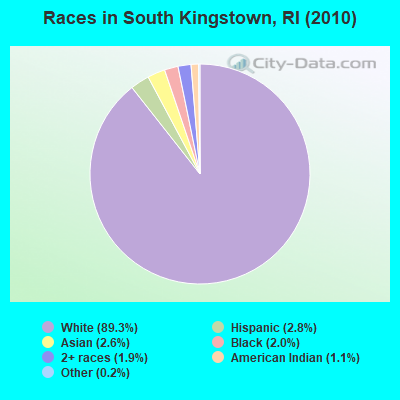
- 27,35289.3%White alone
- 8692.8%Hispanic
- 8092.6%Asian alone
- 6162.0%Black alone
- 5831.9%Two or more races
- 3381.1%American Indian alone
- 660.2%Other race alone
- 60.02%Native Hawaiian and Other
Pacific Islander alone
Races in South Kingstown detailed stats: ancestries, foreign born residents, place of birth
According to our research of Rhode Island and other state lists, there were 8 registered sex offenders living in South Kingstown, Rhode Island as of April 28, 2024.
The ratio of all residents to sex offenders in South Kingstown is 3,830 to 1.
The ratio of registered sex offenders to all residents in this city is much lower than the state average.
Type |
2009 |
2010 |
2011 |
2012 |
2013 |
2014 |
2015 |
2016 |
2017 |
2018 |
2019 |
2020 |
2021 |
2022 |
|---|---|---|---|---|---|---|---|---|---|---|---|---|---|---|
| Murders (per 100,000) | 0 (0.0) | 0 (0.0) | 0 (0.0) | 0 (0.0) | 0 (0.0) | 0 (0.0) | 0 (0.0) | 0 (0.0) | 0 (0.0) | 0 (0.0) | 0 (0.0) | 0 (0.0) | 0 (0.0) | 0 (0.0) |
| Rapes (per 100,000) | 3 (10.2) | 2 (6.5) | 5 (16.3) | 4 (13.1) | 7 (23.1) | 5 (16.3) | 4 (13.0) | 2 (6.5) | 4 (13.0) | 8 (26.0) | 8 (26.1) | 4 (13.2) | 5 (15.9) | 12 (37.4) |
| Robberies (per 100,000) | 1 (3.4) | 4 (13.1) | 4 (13.1) | 6 (19.7) | 2 (6.6) | 1 (3.3) | 2 (6.5) | 1 (3.2) | 2 (6.5) | 2 (6.5) | 1 (3.3) | 1 (3.3) | 0 (0.0) | 0 (0.0) |
| Assaults (per 100,000) | 7 (23.9) | 11 (35.9) | 16 (52.3) | 16 (52.4) | 12 (39.6) | 8 (26.0) | 15 (48.7) | 10 (32.4) | 8 (26.0) | 7 (22.7) | 10 (32.6) | 10 (33.1) | 11 (34.9) | 3 (9.4) |
| Burglaries (per 100,000) | 70 (239.2) | 103 (336.2) | 99 (323.5) | 67 (219.5) | 77 (254.0) | 73 (237.6) | 65 (211.1) | 63 (204.1) | 46 (149.2) | 34 (110.3) | 31 (101.1) | 21 (69.4) | 26 (82.4) | 11 (34.3) |
| Thefts (per 100,000) | 242 (826.8) | 253 (825.7) | 264 (862.7) | 197 (645.4) | 211 (696.2) | 199 (647.7) | 199 (646.4) | 170 (550.7) | 147 (476.9) | 161 (522.5) | 172 (561.1) | 107 (353.9) | 92 (291.7) | 117 (365.1) |
| Auto thefts (per 100,000) | 13 (44.4) | 12 (39.2) | 9 (29.4) | 9 (29.5) | 10 (33.0) | 8 (26.0) | 8 (26.0) | 16 (51.8) | 5 (16.2) | 8 (26.0) | 11 (35.9) | 7 (23.1) | 9 (28.5) | 10 (31.2) |
| Arson (per 100,000) | 4 (13.7) | 3 (9.8) | 2 (6.5) | 5 (16.4) | 1 (3.3) | 5 (16.3) | 0 (0.0) | 2 (6.5) | 2 (6.5) | 0 (0.0) | 1 (3.3) | 0 (0.0) | 0 (0.0) | 2 (6.2) |
| City-Data.com crime index | 67.4 | 76.0 | 87.0 | 70.4 | 76.6 | 63.8 | 64.8 | 53.1 | 48.3 | 58.0 | 60.8 | 39.1 | 39.4 | 51.3 |
The City-Data.com crime index weighs serious crimes and violent crimes more heavily. Higher means more crime, U.S. average is 246.1. It adjusts for the number of visitors and daily workers commuting into cities.
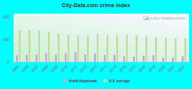
Crime rate in South Kingstown detailed stats: murders, rapes, robberies, assaults, burglaries, thefts, arson
Full-time law enforcement employees in 2021, including police officers: 69 (54 officers - 50 male; 4 female).
| Officers per 1,000 residents here: | 1.71 |
| Rhode Island average: | 2.27 |
 Recent articles from our blog. Our writers, many of them Ph.D. graduates or candidates, create easy-to-read articles on a wide variety of topics.
Ancestries: Irish (23.9%), English (18.6%), Italian (16.5%), French (9.1%), German (8.5%), Polish (4.9%).
Current Local Time: EST time zone
Incorporated in 1723
Land area: 57.1 square miles.
Population density: 537 people per square mile (low).
1,605 residents are foreign born (2.9% Asia, 1.8% Europe).
| This town: | 5.7% |
| Rhode Island: | 11.4% |
| South Kingstown town: | 1.7% ($2,888) |
| Rhode Island: | 1.9% ($2,507) |
Nearest city with pop. 50,000+: Warwick, RI  (19.6 miles , pop. 85,808).
Nearest city with pop. 200,000+: Boston, MA (64.5 miles , pop. 589,141).
Nearest city with pop. 1,000,000+: Bronx, NY (129.1 miles , pop. 1,332,650).
Nearest cities:
), ), Latitude: 41.45 N, Longitude: 71.53 W
Area code commonly used in this area: 401
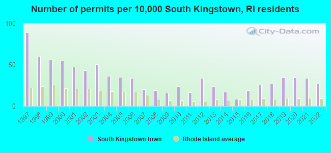
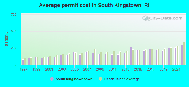
Single-family new house construction building permits:
- 2022: 75 buildings, average cost: $298,700
- 2021: 94 buildings, average cost: $263,400
- 2020: 96 buildings, average cost: $250,300
- 2019: 97 buildings, average cost: $211,500
- 2018: 78 buildings, average cost: $226,200
- 2017: 73 buildings, average cost: $234,100
- 2016: 53 buildings, average cost: $210,700
- 2015: 24 buildings, average cost: $224,800
- 2014: 48 buildings, average cost: $268,000
- 2013: 67 buildings, average cost: $173,300
- 2012: 95 buildings, average cost: $158,100
- 2011: 46 buildings, average cost: $156,100
- 2010: 68 buildings, average cost: $164,800
- 2009: 45 buildings, average cost: $159,100
- 2008: 54 buildings, average cost: $175,500
- 2007: 57 buildings, average cost: $186,700
- 2006: 95 buildings, average cost: $156,200
- 2005: 98 buildings, average cost: $187,300
- 2004: 102 buildings, average cost: $151,200
- 2003: 141 buildings, average cost: $143,100
- 2002: 121 buildings, average cost: $116,200
- 2001: 133 buildings, average cost: $112,400
- 2000: 154 buildings, average cost: $105,000
- 1999: 158 buildings, average cost: $112,100
- 1998: 169 buildings, average cost: $101,900
- 1997: 248 buildings, average cost: $76,500
| Here: | 2.5% |
| Rhode Island: | 3.3% |
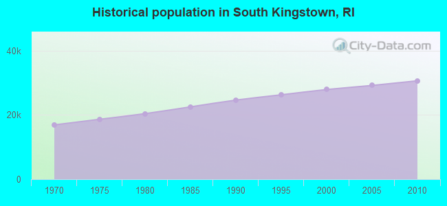
Population change in the 1990s: +3,223 (+13.0%).
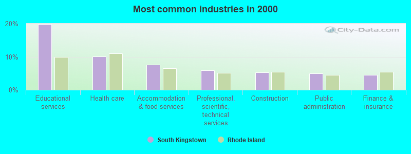
- Educational services (19.8%)
- Health care (10.0%)
- Accommodation & food services (7.6%)
- Professional, scientific, technical services (5.9%)
- Construction (5.3%)
- Public administration (5.0%)
- Finance & insurance (4.5%)
- Educational services (16.0%)
- Construction (9.4%)
- Professional, scientific, technical services (6.8%)
- Accommodation & food services (6.5%)
- Public administration (6.3%)
- Health care (4.8%)
- Finance & insurance (4.7%)
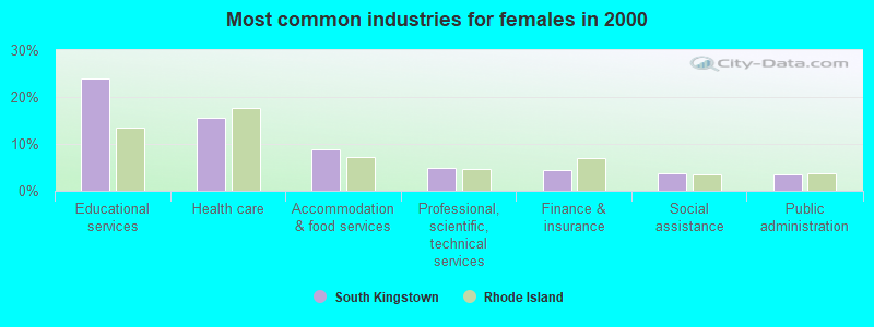
- Educational services (24.0%)
- Health care (15.6%)
- Accommodation & food services (8.9%)
- Professional, scientific, technical services (4.8%)
- Finance & insurance (4.3%)
- Social assistance (3.7%)
- Public administration (3.6%)
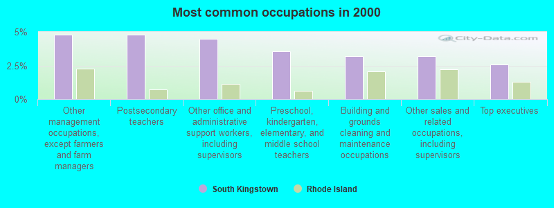
- Other management occupations, except farmers and farm managers (4.8%)
- Postsecondary teachers (4.8%)
- Other office and administrative support workers, including supervisors (4.5%)
- Preschool, kindergarten, elementary, and middle school teachers (3.5%)
- Building and grounds cleaning and maintenance occupations (3.2%)
- Other sales and related occupations, including supervisors (3.2%)
- Top executives (2.6%)
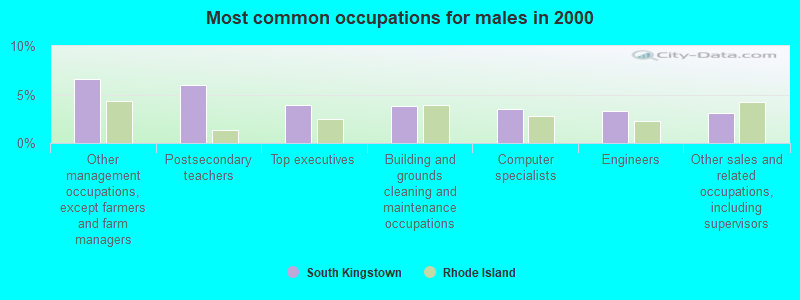
- Other management occupations, except farmers and farm managers (6.6%)
- Postsecondary teachers (5.9%)
- Top executives (3.9%)
- Building and grounds cleaning and maintenance occupations (3.8%)
- Computer specialists (3.6%)
- Engineers (3.3%)
- Other sales and related occupations, including supervisors (3.0%)

- Other office and administrative support workers, including supervisors (6.5%)
- Preschool, kindergarten, elementary, and middle school teachers (6.0%)
- Secretaries and administrative assistants (4.7%)
- Counselors, social workers, and other community and social service specialists (3.8%)
- Waiters and waitresses (3.7%)
- Postsecondary teachers (3.5%)
- Other sales and related occupations, including supervisors (3.3%)
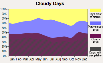
Average climate in South Kingstown, Rhode Island
Based on data reported by over 4,000 weather stations


(lower is better)
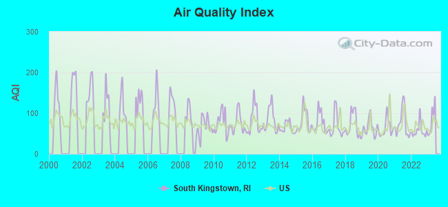
Air Quality Index (AQI) level in 2022 was 56.9. This is better than average.
| City: | 56.9 |
| U.S.: | 72.6 |
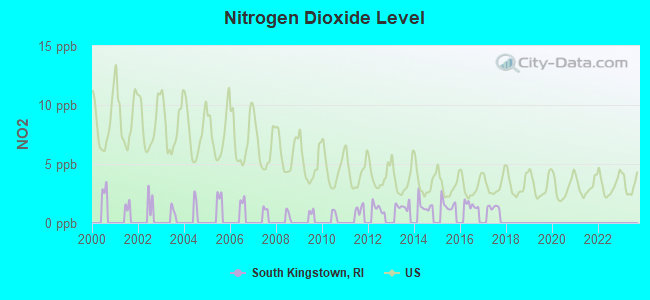
Nitrogen Dioxide (NO2) [ppb] level in 2017 was 1.35. This is significantly better than average. Closest monitor was 3.4 miles away from the city center.
| City: | 1.35 |
| U.S.: | 5.11 |
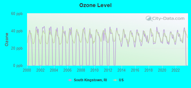
Ozone [ppb] level in 2022 was 32.7. This is about average. Closest monitor was 6.3 miles away from the city center.
| City: | 32.7 |
| U.S.: | 33.3 |
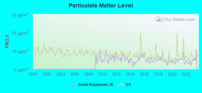
Particulate Matter (PM2.5) [µg/m3] level in 2022 was 3.76. This is significantly better than average. Closest monitor was 6.3 miles away from the city center.
| City: | 3.76 |
| U.S.: | 8.11 |
Tornado activity:
South Kingstown-area historical tornado activity is slightly below Rhode Island state average. It is 64% smaller than the overall U.S. average.
On 6/9/1953, a category F4 (max. wind speeds 207-260 mph) tornado 59.0 miles away from the South Kingstown town center killed 90 people and injured 1228 people and caused between $50,000,000 and $500,000,000 in damages.
On 6/9/1953, a category F3 (max. wind speeds 158-206 mph) tornado 45.0 miles away from the town center injured 17 people and caused between $500,000 and $5,000,000 in damages.
Earthquake activity:
South Kingstown-area historical earthquake activity is significantly above Rhode Island state average. It is 74% smaller than the overall U.S. average.On 10/7/1983 at 10:18:46, a magnitude 5.3 (5.1 MB, 5.3 LG, 5.1 ML, Class: Moderate, Intensity: VI - VII) earthquake occurred 224.7 miles away from the city center
On 4/20/2002 at 10:50:47, a magnitude 5.3 (5.3 ML, Depth: 3.0 mi) earthquake occurred 238.7 miles away from South Kingstown center
On 4/20/2002 at 10:50:47, a magnitude 5.2 (5.2 MB, 4.2 MS, 5.2 MW, 5.0 MW) earthquake occurred 237.7 miles away from the city center
On 1/19/1982 at 00:14:42, a magnitude 4.7 (4.5 MB, 4.7 MD, 4.5 LG, Class: Light, Intensity: IV - V) earthquake occurred 142.0 miles away from South Kingstown center
On 8/22/1992 at 12:20:32, a magnitude 4.8 (4.8 MB, 3.8 MS, 4.7 LG, Depth: 6.2 mi) earthquake occurred 174.0 miles away from South Kingstown center
On 10/16/2012 at 23:12:25, a magnitude 4.7 (4.7 ML, Depth: 10.0 mi) earthquake occurred 155.2 miles away from the city center
Magnitude types: regional Lg-wave magnitude (LG), body-wave magnitude (MB), duration magnitude (MD), local magnitude (ML), surface-wave magnitude (MS), moment magnitude (MW)
Natural disasters:
The number of natural disasters in Washington County (17) is near the US average (15).Major Disasters (Presidential) Declared: 8
Emergencies Declared: 9
Causes of natural disasters: Hurricanes: 6, Snowstorms: 4, Blizzards: 3, Floods: 2, Storms: 2, Winter Storms: 2, Snow: 1, Snowfall: 1, Tropical Storm: 1, Wind: 1, Other: 1 (Note: some incidents may be assigned to more than one category).
Hospitals and medical centers in South Kingstown:
Other hospitals and medical centers near South Kingstown:
- WAKEFIELD DIALYSIS CENTER (Dialysis Facility, about 2 miles away; WAKEFIELD, RI)
- SOUTH BAY MANOR (Nursing Home, about 2 miles away; WAKEFIELD, RI)
- SOUTH COUNTY HOSPITAL INC Acute Care Hospitals (about 3 miles away; WAKEFIELD, RI)
- HOSPICE OF WASHINGTON COUNTY, INC (Hospital, about 3 miles away; WAKEFIELD, RI)
- VNS HOME HEALTH SERVICES (Home Health Center, about 3 miles away; NARRAGANSETT, RI)
- HOSPICE OF VNS WASH CO AND JAMESTOWN (Hospital, about 3 miles away; NARRAGANSETT, RI)
- SOUTH KINGSTOWN AND NURSING REHABILITATION CENTER (Nursing Home, about 5 miles away; WEST KINGSTON, RI)
Amtrak stations near South Kingstown:
- 4 miles: KINGSTON (WEST KINGSTON, FAIRGROUNDS RD.) . Services: ticket office, enclosed waiting area, public restrooms, public payphones, free short-term parking, free long-term parking, call for car rental service, call for taxi service, public transit connection.
- 17 miles: WESTERLY (14 RAILROAD AVE.) . Services: ticket office, enclosed waiting area, public restrooms, public payphones, vending machines, paid short-term parking, call for car rental service, call for taxi service, public transit connection.
Colleges/universities with over 2000 students nearest to South Kingstown:
- University of Rhode Island (about 3 miles; Kingston, RI; Full-time enrollment: 14,656)
- Salve Regina University (about 12 miles; Newport, RI; FT enrollment: 2,349)
- New England Institute of Technology (about 15 miles; East Greenwich, RI; FT enrollment: 3,183)
- Community College of Rhode Island (about 19 miles; Warwick, RI; FT enrollment: 10,500)
- Roger Williams University (about 20 miles; Bristol, RI; FT enrollment: 4,375)
- Johnson & Wales University-Providence (about 27 miles; Providence, RI; FT enrollment: 10,898)
- Rhode Island School of Design (about 27 miles; Providence, RI; FT enrollment: 2,714)
Points of interest:
Notable locations in South Kingstown: Kingston Fairgrounds (A), Laurel Lane Golf Course (B), Cards Camp (C), Saint Savios Boys Center (D), Burlingame Brook (E), Peace Dale Museum of Primitive Culture and Nineteenth Century Mill Village (F), Perryville State Trout Hatchery (G), Camp Hoffman (H), Richmond Grange (I), Camp Fuller (J), Browning Beach (K), Camp Saugatucket (L), Bedrock Farm (M), Carpenters Grist Mill (N), Kenyon Grist Mill (O), South Kingston Town Hall (P), South Kingstown Public Library (Q), Robert Beverly Hale Memorial Library (R), University of Rhode Island Emergency Medical Services Headquarters (S), South Kingstown Emergency Medical Services (T). Display/hide their locations on the map
Shopping Centers: Colonial Shopping Center (1), Belmont Shoppers Park Shopping Center (2), The Wakefield Mall Shopping Center (3), Dale Carlia Shopping Center (4). Display/hide their locations on the map
Churches in South Kingstown include: Christ United Methodist Church (A), Christ the King Church (B), Lutheran Church of the Good Shepherd (C), Kingston Congregational Church (D), Saint Augustines Church (E), Unitarian Universalist Congregation of South County (F), Wakefield Baptist Church (G), West Kingston Baptist Church (H), Perryville Baptist Church (I). Display/hide their locations on the map
Cemeteries: Tower Hill Cemetery (1), Fernwood Cemetery (2), Riverside Cemetery (3). Display/hide their locations on the map
Lakes, reservoirs, and swamps: Yawgoo Pond (A), Thirty Acre Pond (B), Card Ponds (C), Barber Pond (D), Hundred Acre Pond (E), Indian Lake (F), Saugatucket Pond (G), Silver Lake (H). Display/hide their locations on the map
Streams, rivers, and creeks: Glen Rock Brook (A), Saugatucket River (B), Chipuxet River (C), Indian Run (D), Mink Brook (E), Rake Factory Brook (F), White Horn Brook (G), Genesee Brook (H), Sherman Brook (I). Display/hide their locations on the map
Parks in South Kingstown include: Succotash Marsh State Management Area (1), South Shore Management Area (2), Great Swamp Wildlife Reservation (3), Peace Dale Historic District (4), Kingston Village Historic District (5), Old Mountain Field (6), Truston Pond National Wildlife Refuge (7), Great Swamp Fight Site (8). Display/hide their locations on the map
Beaches: Roy Carpenters Beach (A), Willow Dell Beach (B), East Matunuck State Beach (C). Display/hide their locations on the map
Court: Rhode Island State - Courts- Supreme Court- Domestic Violence Training & Monitoring (250 Benefit Prov 02903) (1). Display/hide its approximate location on the map
Birthplace of: Oliver Hazard Perry - Naval Officer, Isaac P. Rodman - Union Army general, Aaron Rossi - Drummer, Sean Maloney (baseball) - Baseball player.
| This town: | 2.4 people |
| Rhode Island: | 2.4 people |
| This town: | 64.4% |
| Whole state: | 62.8% |
| This town: | 6.4% |
| Whole state: | 7.6% |
Likely homosexual households (counted as self-reported same-sex unmarried-partner households)
- Lesbian couples: 0.5% of all households
- Gay men: 0.4% of all households
| This town: | 5.3% |
| Whole state: | 11.9% |
| This town: | 2.1% |
| Whole state: | 5.4% |
People in group quarters in South Kingstown in 2010:
- 5,125 people in college/university student housing
- 274 people in nursing facilities/skilled-nursing facilities
- 83 people in workers' group living quarters and job corps centers
- 43 people in group homes intended for adults
- 18 people in emergency and transitional shelters (with sleeping facilities) for people experiencing homelessness
- 12 people in other noninstitutional facilities
- 7 people in group homes for juveniles (non-correctional)
People in group quarters in South Kingstown in 2000:
- 3,915 people in college dormitories (includes college quarters off campus)
- 177 people in nursing homes
- 64 people in homes for the mentally retarded
- 16 people in other noninstitutional group quarters
- 8 people in other workers' dormitories
Banks with branches in South Kingstown (2011 data):
- The Washington Trust Company of Westerly: Wakefield Branch at 730 Kingstown Road, branch established on 1995/10/23. Info updated 2006/11/03: Bank assets: $3,059.8 mil, Deposits: $2,127.5 mil, headquarters in Westerly, RI, positive income, Commercial Lending Specialization, 19 total offices, Holding Company: Washington Trust Bancorp, Inc.
For population 15 years and over in South Kingstown:
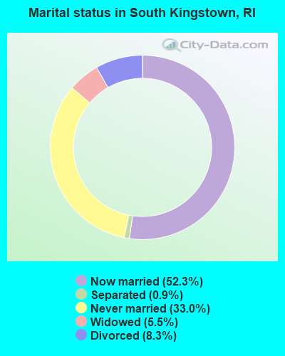
- Never married: 33.0%
- Now married: 52.3%
- Separated: 0.9%
- Widowed: 5.5%
- Divorced: 8.3%
For population 25 years and over in South Kingstown:
- High school or higher: 91.3%
- Bachelor's degree or higher: 46.8%
- Graduate or professional degree: 19.9%
- Unemployed: 8.8%
- Mean travel time to work (commute): 22.8 minutes
| Here: | 11.7 |
| Rhode Island average: | 14.0 |
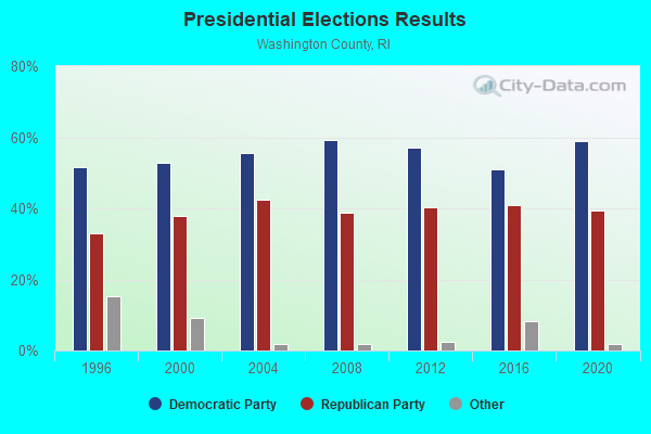
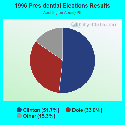
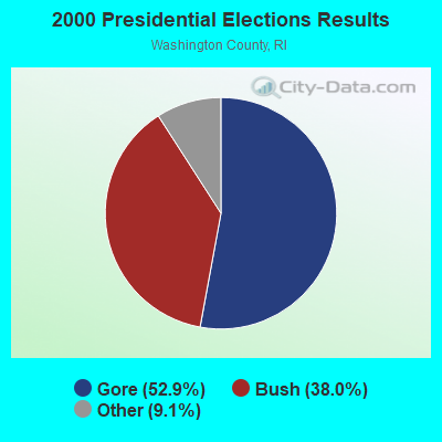
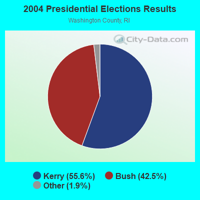
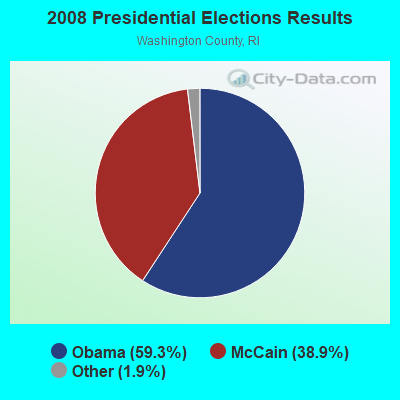
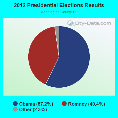
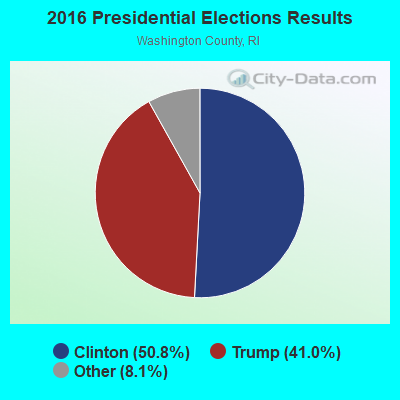

Graphs represent county-level data. Detailed 2008 Election Results
Political contributions by individuals in South Kingstown, RI
Religion statistics for South Kingstown, RI (based on Washington County data)
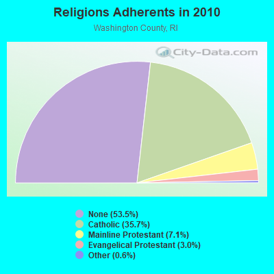
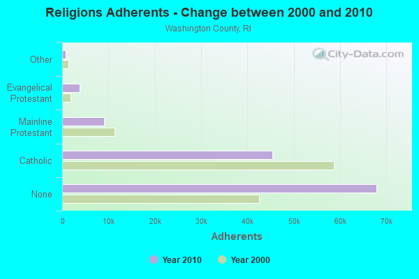
| Religion | Adherents | Congregations |
|---|---|---|
| Catholic | 45,382 | 17 |
| Mainline Protestant | 9,057 | 34 |
| Evangelical Protestant | 3,841 | 33 |
| Other | 796 | 8 |
| None | 67,903 | - |
Food Environment Statistics:
| Here: | 2.45 / 10,000 pop. |
| State: | 1.92 / 10,000 pop. |
| This county: | 0.08 / 10,000 pop. |
| Rhode Island: | 0.05 / 10,000 pop. |
| Washington County: | 1.34 / 10,000 pop. |
| Rhode Island: | 1.42 / 10,000 pop. |
| Washington County: | 2.21 / 10,000 pop. |
| State: | 2.24 / 10,000 pop. |
| Washington County: | 12.41 / 10,000 pop. |
| Rhode Island: | 9.75 / 10,000 pop. |
| Washington County: | 6.8% |
| State: | 7.9% |
| Here: | 19.8% |
| State: | 22.6% |
| Washington County: | 14.2% |
| Rhode Island: | 16.3% |
Businesses in South Kingstown, RI
- Dunkin Donuts: 1
- Hilton: 1
- Holiday Inn: 1
Strongest AM radio stations in South Kingstown:
- WALE (990 AM; 50 kW; GREENVILLE, RI; Owner: NORTH AMERICAN BROADCASTING CO., INC.)
- WCRN (830 AM; 50 kW; WORCESTER, MA; Owner: CARTER BROADCASTING CORPORATION)
- WEEI (850 AM; 50 kW; BOSTON, MA; Owner: ENTERCOM BOSTON LICENSE, LLC)
- WRKO (680 AM; 50 kW; BOSTON, MA; Owner: ENTERCOM BOSTON LICENSE, LLC)
- WKOX (1200 AM; 50 kW; FRAMINGHAM, MA; Owner: CAPSTAR TX LIMITED PARTNERSHIP)
- WPRO (630 AM; 5 kW; PROVIDENCE, RI; Owner: CITADEL BROADCASTING COMPANY)
- WNNZ (640 AM; 50 kW; WESTFIELD, MA; Owner: CLEAR CHANNEL BROADCASTING LICENSES, INC.)
- WBIX (1060 AM; 40 kW; NATICK, MA; Owner: LANGER BROADCASTING CORPORATION)
- WBZ (1030 AM; 50 kW; BOSTON, MA; Owner: INFINITY BROADCASTING OPERATIONS, INC.)
- WJJF (1180 AM; daytime; 2 kW; HOPE VALLEY, RI; Owner: CHARLES RIVER BROADCASTING WJJF LICENSE CORPORATION)
- WRNI (1290 AM; 10 kW; PROVIDENCE, RI; Owner: WRNI FOUNDATION)
- WTIC (1080 AM; 50 kW; HARTFORD, CT; Owner: INFINITY RADIO OPERATIONS INC.)
- WAMG (890 AM; 25 kW; DEDHAM, MA; Owner: MEGA COMMUNICATIONS OF DEDHAM LICENSEE, LLC)
Strongest FM radio stations in South Kingstown:
- WRIU (90.3 FM; KINGSTON, RI; Owner: UNIVERSITY OF RHODE ISLAND)
- WAKX (102.7 FM; NARRAGANSETT PIER, RI; Owner: AAA ENTERTAINMENT LICENSING LLC)
- WSKO-FM (99.7 FM; WAKEFIELD-PEACEDALE, RI; Owner: CITADEL BROADCASTING COMPANY)
- WKKB (100.3 FM; MIDDLETOWN, RI; Owner: CITADEL BROADCASTING COMPANY)
- WWRX-FM (103.7 FM; WESTERLY, RI; Owner: FNX BROADCASTING OF RHODE ISLAND, LLC)
- WWBB (101.5 FM; PROVIDENCE, RI; Owner: CLEAR CHANNEL BROADCASTING LICENSES, INC.)
- WHJM (107.7 FM; PAWCATUCK, CT; Owner: FULLER BROADCASTING INTERNATIONAL, LLC)
- WXLM (102.3 FM; STONINGTON, CT; Owner: CITADEL BROADCASTING COMPANY)
- WPRO-FM (92.3 FM; PROVIDENCE, RI; Owner: CITADEL BROADCASTING COMPANY)
- WWLI (105.1 FM; PROVIDENCE, RI; Owner: CITADEL BROADCASTING COMPANY)
- W243AI (96.5 FM; NEWPORT, RI; Owner: DAVID P. MAXSON)
- WSNE-FM (93.3 FM; TAUNTON, MA; Owner: CAPSTAR TX LIMITED PARTNERSHIP)
- WBMW (106.5 FM; LEDYARD, CT; Owner: RED WOLF BROADCASTING CORPORATION)
- WBRU (95.5 FM; PROVIDENCE, RI; Owner: BROWN BROADCASTING SERVICE, INC.)
- WHJY (94.1 FM; PROVIDENCE, RI; Owner: CAPSTAR TX LIMITED PARTNERSHIP)
- WADK-FM (99.3 FM; BLOCK ISLAND, RI; Owner: ASTRO TELE-COMMUNICATIONS CORP.)
- WCRI (95.9 FM; BLOCK ISLAND, RI; Owner: CHARLES RIVER BROADCASTING WCRI LICENSE CORP.)
TV broadcast stations around South Kingstown:
- WPXQ (Channel 69; BLOCK ISLAND, RI; Owner: OCEAN STATE TELEVISION, L.L.C.)
- WHPX (Channel 26; NEW LONDON, CT; Owner: PAXSON HARTFORD LICENSE, INC.)
- WNAC-TV (Channel 64; PROVIDENCE, RI; Owner: WNAC, LLC)
- WLNE-TV (Channel 6; NEW BEDFORD, MA; Owner: FREEDOM BROADCASTING OF SOUTHERN NEW ENGLAND, INC.)
- WPRI-TV (Channel 12; PROVIDENCE, RI; Owner: TVL BROADCASTING OF RHODE ISLAND, LLC)
- WJAR (Channel 10; PROVIDENCE, RI; Owner: OUTLET BROADCASTING, INC.)
- WSBE-TV (Channel 36; PROVIDENCE, RI; Owner: RHODE ISLAND PUBLIC TELECOM. AUTHORITY)
- WRIW-LP (Channel 50; PROVIDENCE, RI; Owner: ZGS PROVIDENCE, INC.)
- National Bridge Inventory (NBI) Statistics
- 23Number of bridges
- 151ft / 46.0mTotal length
- $28,096,000Total costs
- 167,188Total average daily traffic
- 8,923Total average daily truck traffic
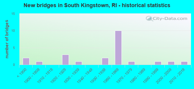
- New bridges - historical statistics
- 2Before 1900
- 11900-1909
- 31920-1929
- 11930-1939
- 21950-1959
- 101960-1969
- 11970-1979
- 11990-1999
- 12000-2009
- 12010-2019
FCC Registered Cell Phone Towers:
1- 2935 Tower Hill Road (Lat: 41.498167 Lon: -71.458639), Type: Ltower, Structure height: 55.8 m, Call Sign: KNKA292
Assigned Frequencies: 869.040 MHz, 869.040 MHz, 869.040 MHz, 824.040 MHz, 824.040 MHz, 824.040 MHz, 890.010 MHz, 890.010 MHz, 890.010 MHz, 845.010 MHz, 845.010 MHz, 845.010 MHzGrant Date: 09/07/2016, Expiration Date: 10/01/2026, Certifier: David C JatlowRegistrant: At&t Services, Inc., 208 S Akard St, 20f, Dallas, TX 75202, Phone: (855) 699-7073, Fax: (214) 746-6410, Email:
FCC Registered Antenna Towers:
4- Douglas I Brandon, 509 Commodore Perry Highway (Lat: 41.429861 Lon: -71.497417), Type: 76.2, Overall height: 76.2 m, Registrant: Town Of South Kingstown, Wakef-ield, Phone: (401) 443-1003
- Douglas I Brandon, 509 Commodore Perry Highway (Lat: 41.429861 Lon: -71.497417), Type: 76.2, Overall height: 76.2 m, Registrant: Town Of South Kingstown, Wakef-ield, Phone: (401) 443-1003
- Edward G Roach, 104 Rose Hill Road (Ri11716-S) (Lat: 41.469361 Lon: -71.497556), Type: 48.5, Structure height: 44009 m, Overall height: 45.7 m, Registrant: Sba Towers Ii LLC, Eroach@sbasite.Com, , Boca -Raton, Phone: (561) 995-7670
- Edward G Roach, 104 Rose Hill Road (Ri11716-S) (Lat: 41.469361 Lon: -71.497556), Type: 48.5, Structure height: 44009 m, Overall height: 45.7 m, Registrant: Sba Towers Ii LLC, Eroach@sbasite.Com, , Boca -Raton, Phone: (561) 995-7670
FCC Registered Private Land Mobile Towers:
2- 385 Tower Hill Rd (Lat: 41.497333 Lon: -71.457556), Type: Tower, Structure height: 30 m, Call Sign: WPFI544,
Assigned Frequencies: 929.287 MHz, 929.562 MHz, 929.612 MHz, Grant Date: 12/27/2000, Expiration Date: 09/06/2010, Cancellation Date: 06/28/2001, Registrant: Paging Network Of America, Inc., 1500 International Pkwy, Suite 300, Richardson, TX 75081, Phone: (972) 801-0304, Fax: (972) 801-0330
- 385 Tower Hill Rd (Lat: 41.497333 Lon: -71.457556), Type: Tower, Structure height: 30 m, Call Sign: WPGR951, Licensee ID: L00120834,
Assigned Frequencies: 929.987 MHz, Grant Date: 03/08/2000, Expiration Date: 03/08/2010, Cancellation Date: 04/29/2003, Registrant: Map Paging Co Inc, 840 Greenbrier Cir Ste 202, Chesapeake, VA 23320, Phone: (757) 424-1191
FCC Registered Broadcast Land Mobile Towers:
2- Ri Fish & Wildlife Great Swamp Wildlife Reservation Off Liberty Lane (Lat: 41.477333 Lon: -71.580611), Call Sign: KCO360, Licensee ID: L00003672,
Assigned Frequencies: 31.5400 MHz, 31.6200 MHz, 31.7400 MHz, Grant Date: 01/08/2002, Expiration Date: 01/08/2012, Cancellation Date: 03/10/2012, Registrant: State Of Rhode Island, Box 218, West Kingston, RI 02892, Phone: (401) 789-0281
- 4124 Tower Hill Rd (Lat: 41.466139 Lon: -71.463083), Type: Ltower, Structure height: 21.3 m, Overall height: 24.4 m, Call Sign: KBO581,
Assigned Frequencies: 453.450 MHz, 453.487 MHz, 453.600 MHz, 453.800 MHz, 453.950 MHz, 460.075 MHz, 460.112 MHz, 460.312 MHz, 460.437 MHz, Grant Date: 07/10/2014, Expiration Date: 08/25/2024, Certifier: Andre Boisvert, Registrant: Marcus Communications, 33 Mitchell Dr, Manchester, CT 06045, Phone: (860) 646-1839, Email:
FCC Registered Microwave Towers:
7- S KINGSTOWN, 2935 Tower Hill Rd (Lat: 41.498167 Lon: -71.458639), Type: Mast, Structure height: 55.8 m, Call Sign: WMR347,
Assigned Frequencies: 10667.5 MHz, 6645.00 MHz, Grant Date: 01/11/2011, Expiration Date: 02/01/2021, Cancellation Date: 07/22/2016, Certifier: Carol L Tacker, Registrant: At&t Mobility LLC, 1120 20th Street, Nw - Suite 1000, Washington, DC 20036, Phone: (202) 457-2055, Fax: (202) 457-3073, Email:
- GREEN HILL, Green Hill Site, 295 Shannock Road (Lat: 41.403472 Lon: -71.604417), Type: Mast, Structure height: 76.5 m, Overall height: 91.4 m, Call Sign: WPNN448,
Assigned Frequencies: 6585.62 MHz, Grant Date: 05/06/2008, Expiration Date: 06/18/2018, Cancellation Date: 09/29/2014, Certifier: Carol L Tacker, Registrant: At&t Mobility LLC, 1120 20th Street, Nw - Suite 1000, Washington, DC 20036, Phone: (202) 457-2055, Fax: (202) 457-3073, Email:
- PD STATION, 1790 Kingstown Road (Lat: 41.462611 Lon: -71.511167), Type: Tower, Structure height: 34 m, Overall height: 40 m, Call Sign: WQEX766,
Assigned Frequencies: 956.750 MHz, Grant Date: 05/12/2006, Expiration Date: 05/12/2016, Cancellation Date: 02/24/2016, Certifier: Brian Ballou, Registrant: Cyber Communications, 90 Colorado Avenue, Warwick, RI 02888, Phone: (401) 738-1470, Fax: (401) 738-8695
- TEFT HILL, 430 Chestnut Hill Road (Lat: 41.463889 Lon: -71.537500), Type: Tank, Structure height: 34 m, Call Sign: WQEX767,
Assigned Frequencies: 953.150 MHz, Grant Date: 05/12/2006, Expiration Date: 05/12/2016, Cancellation Date: 02/24/2016, Certifier: Brian Ballou, Registrant: Cyber Communications, 90 Colorado Avenue, Warwick, RI 02888, Phone: (401) 738-1470, Fax: (401) 738-8695
- UNION FIRE S, 4124 Tower Hill Rd (Lat: 41.466111 Lon: -71.463056), Type: Building, Structure height: 24.3 m, Call Sign: WRWM403,
Assigned Frequencies: 17790.0 MHz, 18090.0 MHz, 17790.0 MHz, 18090.0 MHz, 17790.0 MHz, 18090.0 MHz, 17790.0 MHz, 18090.0 MHz, 17790.0 MHz, 18090.0 MHz... (+12 more), Grant Date: 03/07/2023, Expiration Date: 03/07/2033, Certifier: Lance Whaley, Registrant: Marcus Communications, 33 Mitchell Dr, Manchester, CT 06045, Phone: (860) 646-1839, Email:
- TEFT HILL, 430 Chestnut Hill Rd (Lat: 41.462972 Lon: -71.537778), Type: Tank, Structure height: 34 m, Call Sign: WRWM407,
Assigned Frequencies: 17850.0 MHz, 17910.0 MHz, 18030.0 MHz, 17850.0 MHz, 17910.0 MHz, 18030.0 MHz, 17850.0 MHz, 17910.0 MHz, 18030.0 MHz, 17850.0 MHz... (+34 more), Grant Date: 03/07/2023, Expiration Date: 03/07/2033, Certifier: Lance Whaley, Registrant: Marcus Communications, 33 Mitchell Dr, Manchester, CT 06045, Phone: (860) 646-1839, Email:
- S KINGSTOWN, Rt 1 (Lat: 41.496778 Lon: -71.458667), Type: Tower, Structure height: 60.7 m, Call Sign: WLV801,
Assigned Frequencies: 10633.1 MHz, 10795.0 MHz, Grant Date: 01/25/2011, Expiration Date: 02/01/2021, Cancellation Date: 08/05/2015, Registrant: Verizon Wireless, 1120 Sanctuary Pkwy, #150 Gasa5reg, Alpharetta, GA 30009-7630, Phone: (770) 797-1070, Fax: (770) 797-1036, Email:
FCC Registered Amateur Radio Licenses:
8 (See the full list of FCC Registered Amateur Radio Licenses in South Kingstown)2007 - 2018 National Fire Incident Reporting System (NFIRS) incidents
- Fire incident types reported to NFIRS in South Kingstown, RI
- 25356.1%Structure Fires
- 11124.6%Outside Fires
- 5412.0%Mobile Property/Vehicle Fires
- 337.3%Other
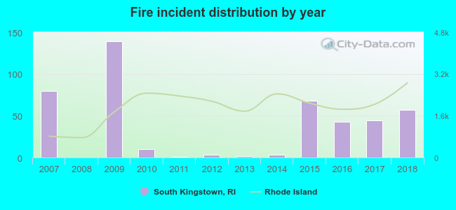 According to the data from the years 2007 - 2018 the average number of fires per year is 38. The highest number of fire incidents - 139 took place in 2009, and the least - 0 in 2008. The data has a decreasing trend.
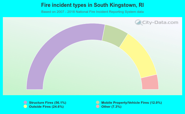 When looking into fire subcategories, the most incidents belonged to: Structure Fires (56.1%), and Outside Fires (24.6%).
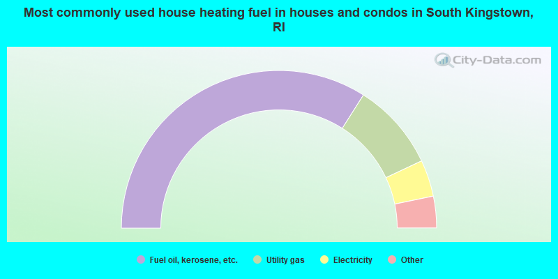
- 68.0%Fuel oil, kerosene, etc.
- 18.0%Utility gas
- 7.5%Electricity
- 3.6%Wood
- 2.3%Bottled, tank, or LP gas
- 0.2%Solar energy
- 0.2%Coal or coke
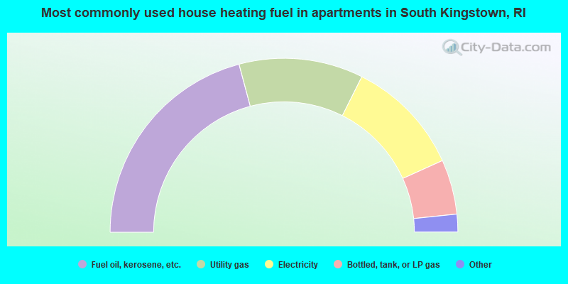
- 41.7%Fuel oil, kerosene, etc.
- 23.1%Utility gas
- 21.7%Electricity
- 10.2%Bottled, tank, or LP gas
- 2.5%Wood
- 0.8%Other fuel
South Kingstown compared to Rhode Island state average:
- Black race population percentage below state average.
- Hispanic race population percentage significantly below state average.
- Median age below state average.
- Foreign-born population percentage significantly below state average.
- Length of stay since moving in significantly above state average.
- Number of rooms per house significantly below state average.
- House age significantly below state average.
- Number of college students above state average.
- Percentage of population with a bachelor's degree or higher above state average.
South Kingstown on our top lists:
- #7 on the list of "Top 101 cities with largest percentage of males in occupations: postsecondary teachers (population 5,000+)"
- #17 on the list of "Top 101 cities with largest percentage of females in occupations: postsecondary teachers (population 5,000+)"
- #42 on the list of "Top 101 cities with largest percentage of females in occupations: counselors, social workers, and other community and social service specialists (population 5,000+)"
- #66 on the list of "Top 101 cities with largest percentage of females in industries: water transportation (population 5,000+)"
- #81 on the list of "Top 101 cities with largest percentage of males in occupations: fishing and hunting, and forest and logging workers (population 5,000+)"
- #83 on the list of "Top 101 cities with largest percentage of females in industries: electrical equipment, appliances, and components (population 5,000+)"
- #84 on the list of "Top 101 cities with largest percentage of females in occupations: air transportation workers (population 5,000+)"
- #98 on the list of "Top 101 cities with largest percentage of females in occupations: social scientists and related workers (population 5,000+)"
- #100 on the list of "Top 101 cities with largest percentage of males in industries: data processing, libraries, and other information services (population 5,000+)"
- #2 on the list of "Top 101 counties with the highest percentage of residents that visited a dentist within the past year"
- #4 on the list of "Top 101 counties with the lowest number of births per 1000 residents 2007-2013"
- #7 on the list of "Top 101 counties with the largest decrease in the number of births per 1000 residents 2000-2006 to 2007-2013 (pop 50,000+)"
- #17 on the list of "Top 101 counties with the best general health status score of residents (1-5), 3 years of data"
- #44 on the list of "Top 101 counties with the highest percentage of residents that smoked 100+ cigarettes in their lives"

|
|
Total of 44 patent applications in 2008-2024.