Southeast Comanche, Oklahoma
Submit your own pictures of this place and show them to the world
- OSM Map
- General Map
- Google Map
- MSN Map

| Males: 7,930 | |
| Females: 6,290 |
| Median resident age: | 34.0 years |
| Oklahoma median age: | 35.5 years |
Zip code: 73501
| Southeast Comanche: | $74,471 |
| OK: | $59,673 |
Estimated per capita income in 2022: $33,386 (it was $17,841 in 2000)
Southeast Comanche CCD income, earnings, and wages data
Estimated median house or condo value in 2022: $171,856 (it was $83,500 in 2000)
| Southeast Comanche: | $171,856 |
| OK: | $191,700 |
Mean prices in 2022: all housing units: $215,611; detached houses: $222,809; townhouses or other attached units: $217,695; in 2-unit structures: $139,102; in 3-to-4-unit structures: $139,086; mobile homes: $99,844; occupied boats, rvs, vans, etc.: $5,461
Southeast Comanche, OK residents, houses, and apartments details
Detailed information about poverty and poor residents in Southeast Comanche, OK


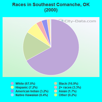
- 9,54267.0%White alone
- 2,40516.9%Black alone
- 1,0297.2%Hispanic
- 4723.3%Two or more races
- 4613.2%American Indian alone
- 2431.7%Asian alone
- 640.4%Native Hawaiian and Other
Pacific Islander alone - 260.2%Other race alone
Races in Southeast Comanche detailed stats: ancestries, foreign born residents, place of birth
 Recent articles from our blog. Our writers, many of them Ph.D. graduates or candidates, create easy-to-read articles on a wide variety of topics.
Current Local Time: CST time zone
Land area: 162.8 square miles.
Population density: 87 people per square mile (very low).

| Southeast Comanche CCD: | 0.7% ($607) |
| Oklahoma: | 0.8% ($523) |
Nearest city with pop. 50,000+: Lawton, OK  (7.4 miles , pop. 92,757).
Nearest city with pop. 200,000+: Oklahoma City, OK (75.3 miles , pop. 506,132).
Nearest city with pop. 1,000,000+: Dallas, TX (150.9 miles , pop. 1,188,580).
Nearest cities:
), ), ), ), Latitude: 34.59 N, Longitude: 98.29 W
Area code commonly used in this area: 580

| Here: | 3.9% |
| Oklahoma: | 3.2% |

- Health care (14.0%)
- Educational services (12.9%)
- Public administration (9.9%)
- Construction (6.2%)
- Accommodation & food services (4.8%)
- Professional, scientific, technical services (4.8%)
- Plastics & rubber products (3.6%)
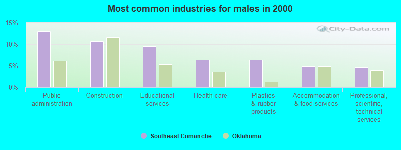
- Public administration (13.0%)
- Construction (10.7%)
- Educational services (9.6%)
- Health care (6.4%)
- Plastics & rubber products (6.4%)
- Accommodation & food services (4.9%)
- Professional, scientific, technical services (4.7%)
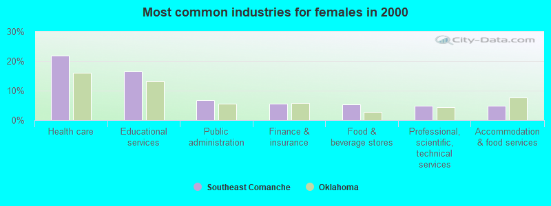
- Health care (21.8%)
- Educational services (16.4%)
- Public administration (6.7%)
- Finance & insurance (5.7%)
- Food & beverage stores (5.3%)
- Professional, scientific, technical services (4.8%)
- Accommodation & food services (4.8%)
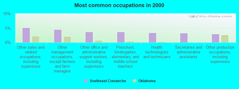
- Other sales and related occupations, including supervisors (5.2%)
- Other management occupations, except farmers and farm managers (4.5%)
- Other office and administrative support workers, including supervisors (3.8%)
- Preschool, kindergarten, elementary, and middle school teachers (3.7%)
- Health technologists and technicians (3.4%)
- Secretaries and administrative assistants (3.3%)
- Other production occupations, including supervisors (3.0%)
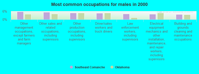
- Other management occupations, except farmers and farm managers (5.9%)
- Other sales and related occupations, including supervisors (5.5%)
- Other production occupations, including supervisors (5.0%)
- Driver/sales workers and truck drivers (4.7%)
- Law enforcement workers, including supervisors (4.2%)
- Electrical equipment mechanics and other installation, maintenance, and repair workers, including supervisors (4.0%)
- Building and grounds cleaning and maintenance occupations (3.9%)
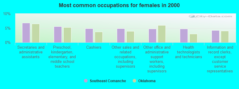
- Secretaries and administrative assistants (6.8%)
- Preschool, kindergarten, elementary, and middle school teachers (5.6%)
- Cashiers (4.9%)
- Other sales and related occupations, including supervisors (4.8%)
- Other office and administrative support workers, including supervisors (4.8%)
- Health technologists and technicians (4.7%)
- Information and record clerks, except customer service representatives (4.2%)
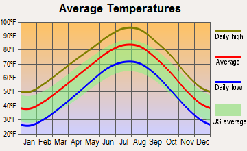
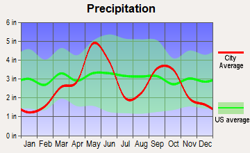
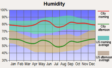
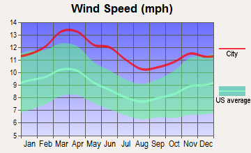
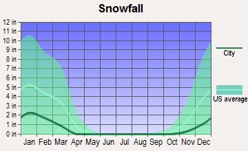
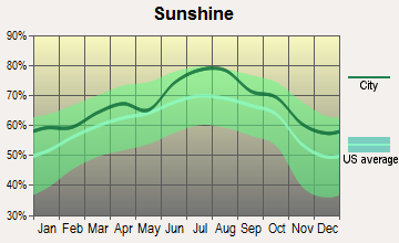
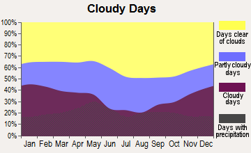
Average climate in Southeast Comanche, Oklahoma
Based on data reported by over 4,000 weather stations
(lower is better)
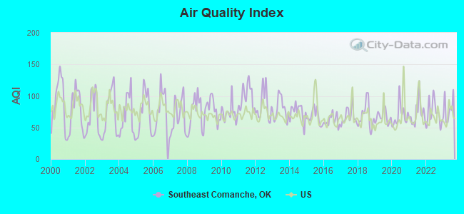
Air Quality Index (AQI) level in 2023 was 79.1. This is about average.
| City: | 79.1 |
| U.S.: | 72.6 |
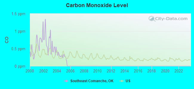
Carbon Monoxide (CO) [ppm] level in 2004 was 0.314. This is worse than average. Closest monitor was 5.9 miles away from the city center.
| City: | 0.314 |
| U.S.: | 0.251 |
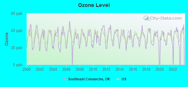
Ozone [ppb] level in 2022 was 35.1. This is about average. Closest monitor was 5.9 miles away from the city center.
| City: | 35.1 |
| U.S.: | 33.3 |
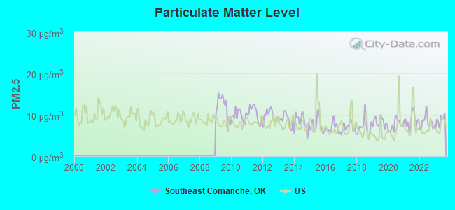
Particulate Matter (PM2.5) [µg/m3] level in 2023 was 8.60. This is about average. Closest monitor was 8.2 miles away from the city center.
| City: | 8.60 |
| U.S.: | 8.11 |
Tornado activity:
Southeast Comanche-area historical tornado activity is near Oklahoma state average. It is 175% greater than the overall U.S. average.
On 5/24/1957, a category F4 (max. wind speeds 207-260 mph) tornado 6.3 miles away from the Southeast Comanche place center killed 4 people and injured 5 people and caused between $50,000 and $500,000 in damages.
On 5/26/1962, a category F4 tornado 21.8 miles away from the place center injured one person and caused between $50,000 and $500,000 in damages.
Earthquake activity:
Southeast Comanche-area historical earthquake activity is significantly above Oklahoma state average. It is 693% greater than the overall U.S. average.On 11/6/2011 at 03:53:10, a magnitude 5.7 (5.7 MW, Depth: 3.2 mi, Class: Moderate, Intensity: VI - VII) earthquake occurred 108.3 miles away from the city center
On 9/3/2016 at 12:02:44, a magnitude 5.8 (5.8 MW, Depth: 3.5 mi) earthquake occurred 148.5 miles away from the city center
On 2/13/2016 at 17:07:06, a magnitude 5.1 (5.1 MW, Depth: 5.2 mi) earthquake occurred 133.7 miles away from Southeast Comanche center
On 6/16/1978 at 11:46:54, a magnitude 5.3 (4.4 MB, 4.6 UK, 5.3 ML) earthquake occurred 178.4 miles away from Southeast Comanche center
On 11/7/2016 at 01:44:24, a magnitude 5.0 (5.0 MW, Depth: 2.8 mi) earthquake occurred 128.4 miles away from the city center
On 11/8/2011 at 02:46:57, a magnitude 4.8 (4.8 MW, Depth: 3.1 mi, Class: Light, Intensity: IV - V) earthquake occurred 107.3 miles away from the city center
Magnitude types: body-wave magnitude (MB), local magnitude (ML), moment magnitude (MW)
Natural disasters:
The number of natural disasters in Comanche County (30) is a lot greater than the US average (15).Major Disasters (Presidential) Declared: 20
Emergencies Declared: 5
Causes of natural disasters: Floods: 13, Storms: 13, Winter Storms: 10, Tornadoes: 7, Fires: 4, Hurricane: 1, Ice Storm: 1, Wind: 1, Other: 1 (Note: some incidents may be assigned to more than one category).
Hospitals and medical centers near Southeast Comanche:
- FMCNA - LAWTON EAST (Dialysis Facility, about 3 miles away; LAWTON, OK)
- SOUTHWESTERN HOME HEALTH, INC (Home Health Center, about 5 miles away; LAWTON, OK)
- USPHS LAWTON INDIAN HOSPITAL Acute Care Hospitals (about 6 miles away; LAWTON, OK)
- AGAPE HOME HEALTH AGENCY (Home Health Center, about 6 miles away; LAWTON, OK)
- ARLINGTON MANOR (Nursing Home, about 7 miles away; LAWTON, OK)
- CEDAR CREST MANOR (Nursing Home, about 8 miles away; LAWTON, OK)
- CREST VIEW LIFE CENTER (Nursing Home, about 8 miles away; LAWTON, OK)
Colleges/universities with over 2000 students nearest to Southeast Comanche:
- Cameron University (about 9 miles; Lawton, OK; Full-time enrollment: 4,695)
- Midwestern State University (about 51 miles; Wichita Falls, TX; FT enrollment: 4,901)
- Western Oklahoma State College (about 60 miles; Altus, OK; FT enrollment: 2,054)
- University of Oklahoma-Norman Campus (about 65 miles; Norman, OK; FT enrollment: 22,496)
- Vernon College (about 66 miles; Vernon, TX; FT enrollment: 2,216)
- Mid-America Christian University (about 67 miles; Oklahoma City, OK; FT enrollment: 2,869)
- Oklahoma City Community College (about 69 miles; Oklahoma City, OK; FT enrollment: 8,904)
Points of interest:
Notable locations in Southeast Comanche: Pumpkin Center (A), Lawton Downs (B), Flower Mound Volunteer Fire Department (C), Coxs Store Volunteer Fire Department (D), Lawton Fire Department Station 6 (E), Hulen Volunteer Fire Department (F), Bethel Road Fire Department (G). Display/hide their locations on the map
Churches in Southeast Comanche include: Church of Christ (A), Carriage Hills Church (B), Aldersgate Church (C), East Church (D), Trinity Assembly of God Church (E), Skyline Missionary Baptist Church (F), Locust Grove Baptist Church (G), Jehovahs Witnesses East Congregation (H), Cornerstone Fellowship Church (I). Display/hide their locations on the map
Cemeteries: Allendale Cemetery (1), Letitia Community Cemetery (2), Flower Mound Community Cemetery (3), Devine Cemetery (4). Display/hide their locations on the map
Reservoirs: Oknoname 031006 Reservoir (A), Oknoname 031004 Reservoir (B), Oknoname 031005 Reservoir (C), Oknoname 031014 Reservoir (D), Oknoname 031027 Reservoir (E), Oknoname 031028 Reservoir (F), Oknoname 031029 Reservoir (G), Oknoname 031030 Reservoir (H). Display/hide their locations on the map
Creeks: Armstrong Creek (A), Ninemile Creek (B), Ninemile Beaver Creek (C), Wrattan Creek (D), Dry Beaver Creek (E). Display/hide their locations on the map
| This place: | 2.6 people |
| Oklahoma: | 2.5 people |
| This place: | 71.9% |
| Whole state: | 66.8% |
| This place: | 4.3% |
| Whole state: | 5.9% |
Likely homosexual households (counted as self-reported same-sex unmarried-partner households)
- Lesbian couples: 0.2% of all households
- Gay men: 0.3% of all households
| This place: | 6.9% |
| Whole state: | 14.7% |
| This place: | 3.1% |
| Whole state: | 6.1% |
People in group quarters in Southeast Comanche in 2010:
- 2,488 people in state prisons
- 199 people in nursing facilities/skilled-nursing facilities
- 8 people in local jails and other municipal confinement facilities
111 people in nursing homes in 2000
For population 15 years and over in Southeast Comanche:
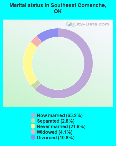
- Never married: 21.9%
- Now married: 63.2%
- Separated: 2.8%
- Widowed: 4.1%
- Divorced: 10.8%
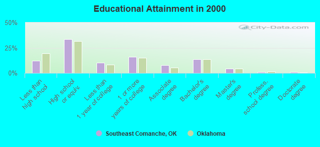
For population 25 years and over in Southeast Comanche:
- High school or higher: 87.7%
- Bachelor's degree or higher: 20.0%
- Graduate or professional degree: 6.4%
- Unemployed: 3.3%
- Mean travel time to work (commute): 19.6 minutes
| Here: | 9.7 |
| Oklahoma average: | 11.7 |
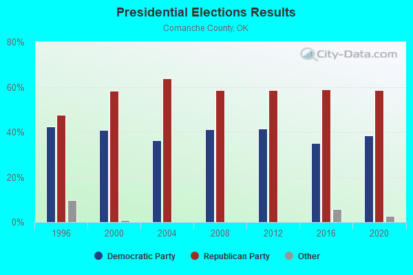
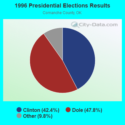
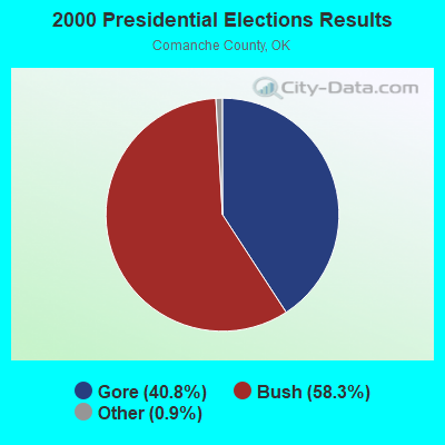
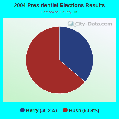
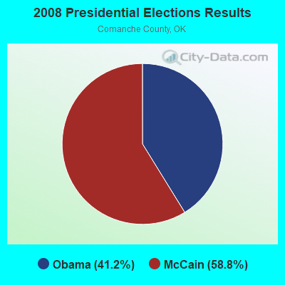
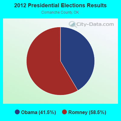
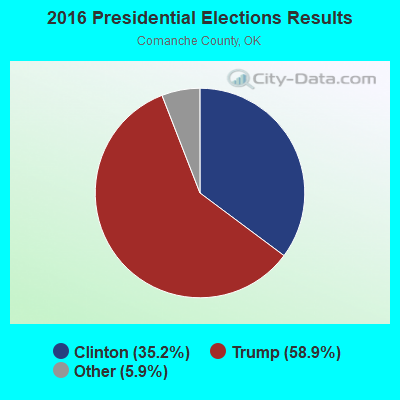
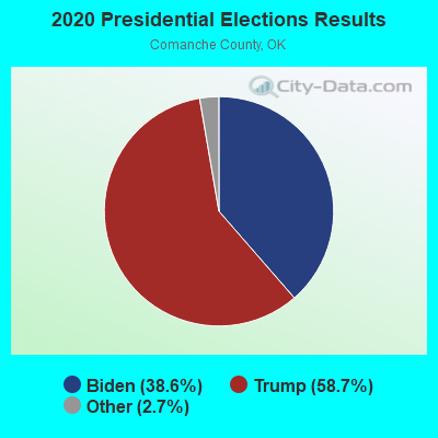
Graphs represent county-level data. Detailed 2008 Election Results
Religion statistics for Southeast Comanche, OK (based on Comanche County data)
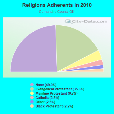
| Religion | Adherents | Congregations |
|---|---|---|
| Evangelical Protestant | 44,224 | 131 |
| Mainline Protestant | 8,366 | 34 |
| Catholic | 4,748 | 3 |
| Other | 3,173 | 9 |
| Black Protestant | 2,714 | 11 |
| Orthodox | 15 | 1 |
| None | 60,858 | - |
Food Environment Statistics:
| Comanche County: | 0.79 / 10,000 pop. |
| Oklahoma: | 1.97 / 10,000 pop. |
| Comanche County: | 0.26 / 10,000 pop. |
| Oklahoma: | 0.20 / 10,000 pop. |
| Comanche County: | 0.53 / 10,000 pop. |
| Oklahoma: | 0.76 / 10,000 pop. |
| Comanche County: | 4.48 / 10,000 pop. |
| Oklahoma: | 4.35 / 10,000 pop. |
| Here: | 5.62 / 10,000 pop. |
| Oklahoma: | 6.89 / 10,000 pop. |
| Comanche County: | 9.4% |
| Oklahoma: | 10.3% |
| Comanche County: | 28.7% |
| Oklahoma: | 29.2% |
10.74% of this county's 2021 resident taxpayers lived in other counties in 2020 ($41,310 average adjusted gross income)
| Here: | 10.74% |
| Oklahoma average: | 8.28% |
0.53% of residents moved from foreign countries ($2,477 average AGI)
Comanche County: 0.53% Oklahoma average: 0.04%
Top counties from which taxpayers relocated into this county between 2020 and 2021:
| from Oklahoma County, OK | |
| from El Paso County, TX | |
| from Bell County, TX |
10.41% of this county's 2020 resident taxpayers moved to other counties in 2021 ($47,448 average adjusted gross income)
| Here: | 10.41% |
| Oklahoma average: | 7.66% |
0.42% of residents moved to foreign countries ($2,168 average AGI)
Comanche County: 0.42% Oklahoma average: 0.03%
Top counties to which taxpayers relocated from this county between 2020 and 2021:
| to Oklahoma County, OK | |
| to Cleveland County, OK | |
| to Stephens County, OK |
Strongest AM radio stations in Southeast Comanche:
- KPTK (1380 AM; 1 kW; LAWTON, OK; Owner: PERRY BROADCASTING OF SOUTHWEST OKLAHOMA, INC.)
- KKRX (1050 AM; 0 kW; LAWTON, OK; Owner: PERRY BROADCASTING OF LAWTON, INC.)
- KOMA (1520 AM; 50 kW; OKLAHOMA CITY, OK; Owner: RENDA BROADCASTING CORP. OF NEVADA)
- KCAF (990 AM; 10 kW; FARMERSVILLE, TX; Owner: RENAISSANCE RADIO, INC.)
- KJON (850 AM; daytime; 5 kW; ANADARKO, OK; Owner: CARROLLTON BROADCASTING OF TEXAS, LP)
- KRMG (740 AM; 50 kW; TULSA, OK; Owner: CXR HOLDINGS, INC.)
- WBAP (820 AM; 50 kW; FORT WORTH, TX; Owner: WBAP-KSCS OPERATING, LTD.)
- KAHZ (1360 AM; 50 kW; HURST, TX)
- KRLD (1080 AM; 50 kW; DALLAS, TX; Owner: TEXAS INFINITY BROADCASTING L.P.)
- KESS (1270 AM; 50 kW; FORT WORTH, TX; Owner: KESS-AM LICENSE CORP.)
- KWFS (1290 AM; 5 kW; WICHITA FALLS, TX; Owner: CCB TEXAS LICENSES, L.P.)
- WWLS (640 AM; 5 kW; MOORE, OK; Owner: CITADEL BROADCASTING COMPANY)
- KFXR (1190 AM; 50 kW; DALLAS, TX; Owner: CLEAR CHANNEL BROADCASTING LICENSES, INC.)
Strongest FM radio stations in Southeast Comanche:
- KCCU (89.3 FM; LAWTON, OK; Owner: CAMERON UNIVERSITY)
- KFXI (92.1 FM; MARLOW, OK; Owner: DFWU, INC.)
- KZCD (94.1 FM; LAWTON, OK; Owner: CAPSTAR TX LIMITED PARTNERSHIP)
- KLAW (101.3 FM; LAWTON, OK; Owner: CAPSTAR TX LIMITED PARTNERSHIP)
- KNIN-FM (92.9 FM; WICHITA FALLS, TX; Owner: CCB TEXAS LICENSES, L.P.)
- KVRW (107.3 FM; LAWTON, OK; Owner: PAT-TOWER, INC.)
- KJRF (91.1 FM; LAWTON, OK; Owner: THE CHRISTIAN CENTER INC)
- KBZQ (99.5 FM; LAWTON, OK; Owner: WILLIAM R. FRITSCH, JR.)
- KMGZ (95.3 FM; LAWTON, OK; Owner: BROADCO OF TEXAS, INC.)
- KSYY (105.3 FM; KINGFISHER, OK; Owner: CITADEL BROADCASTING COMPANY)
- KRMP (103.5 FM; ANADARKO, OK; Owner: PERRY BROADCASTING OF SOUTHWEST OKLAHOMA, INC.)
- KKNG-FM (93.3 FM; NEWCASTLE, OK; Owner: TYLER BROADCASTING CORPORATION)
- KKEN (97.1 FM; DUNCAN, OK; Owner: PERRY BROADCASTING OF SOUTHWEST OKLAHOMA, INC.)
- K275AE (102.9 FM; LAWTON, OK; Owner: CAMERON UNIVERSITY)
- KJMZ (98.1 FM; LAWTON, OK; Owner: PERRY BROADCASTING OF LAWTON, INC.)
- KVRS (90.3 FM; LAWTON, OK; Owner: LAWTON EDUCATIONAL BROADCASTING SERVICES)
- KDDQ (105.3 FM; COMANCHE, OK; Owner: PERRY BROADCASTING OF SOUTHWEST OKLAHOMA, INC.)
TV broadcast stations around Southeast Comanche:
- K49GC (Channel 49; LAWTON, OK; Owner: TRINITY BROADCASTING NETWORK)
- K38GL (Channel 38; LAWTON, OK; Owner: THREE ANGELS BROADCASTING NETWORK)
- K21DC (Channel 21; LAWTON, OK; Owner: LOCKE SUPPLY CO.)
- K53DS (Channel 53; LAWTON, OK; Owner: MISSION BROADCASTING, INC.)
- KSWO-TV (Channel 7; LAWTON, OK; Owner: KSWO TELEVISION COMPANY, INC.)
- KJTL (Channel 18; WICHITA FALLS, TX; Owner: MISSION BROADCASTING, INC.)
- K36AB (Channel 36; LAWTON, OK; Owner: OKLAHOMA EDUC. TELEVISION AUTH.)
- K47DK (Channel 47; GRANDFIELD, OK; Owner: MISSION BROADCASTING, INC.)
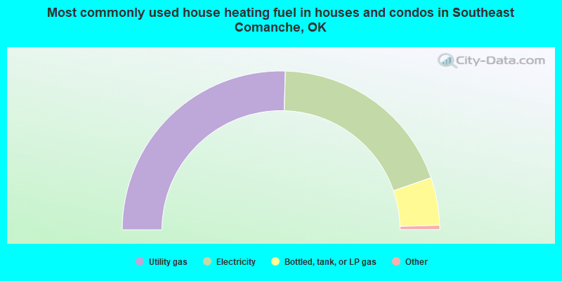
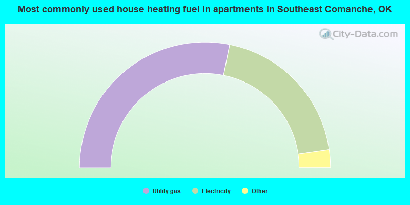
- 50.9%Utility gas
- 38.5%Electricity
- 9.7%Bottled, tank, or LP gas
- 0.3%Fuel oil, kerosene, etc.
- 0.2%Wood
- 0.2%Solar energy
- 0.2%Other fuel
- 56.4%Utility gas
- 39.1%Electricity
- 3.5%Bottled, tank, or LP gas
- 1.1%Wood
Southeast Comanche compared to Oklahoma state average:
- Unemployed percentage significantly below state average.
- Black race population percentage above state average.
- Foreign-born population percentage significantly below state average.
- Length of stay since moving in significantly above state average.
- Number of rooms per house significantly below state average.
- House age significantly below state average.
- Institutionalized population percentage significantly above state average.
Southeast Comanche on our top lists:
- #12 on the list of "Top 101 cities with largest percentage of males in industries: plastics and rubber products (population 5,000+)"
- #13 on the list of "Top 101 cities with largest percentage of males in occupations: other healthcare support occupations (population 5,000+)"
- #15 on the list of "Top 101 cities with largest percentage of males in occupations: other teachers and instructors, education, training, and library occupations (population 5,000+)"
- #32 on the list of "Top 101 cities with largest percentage of males in occupations: occupational and physical therapist assistants and aides (population 5,000+)"
- #53 on the list of "Top 101 cities with largest percentage of females in industries: religious, grantmaking, civic, professional, and similar organizations (population 5,000+)"
- #69 on the list of "Top 101 cities with largest percentage of males in industries: farm product raw materials merchant wholesalers (population 5,000+)"
- #92 on the list of "Top 101 cities with largest percentage of females in industries: health care (population 5,000+)"
- #94 on the list of "Top 101 cities with largest percentage of males in occupations: cooks and food preparation workers (population 5,000+)"
- #13 on the list of "Top 101 counties with the highest percentage of residents relocating to foreign countries in 2011"
- #14 on the list of "Top 101 counties with the highest percentage of residents that smoked 100+ cigarettes in their lives"
- #16 on the list of "Top 101 counties with the highest percentage of residents relocating to other counties in 2011 (pop. 50,000+)"
- #20 on the list of "Top 101 counties with the highest percentage of residents relocating from foreign countries between 2010 and 2011"
- #27 on the list of "Top 101 counties with the worst general health status score of residents (1-5), 3 years of data"