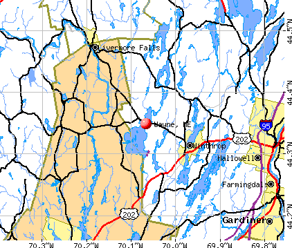
Wayne, Maine
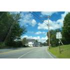
Wayne: On the road into wayne, Maine

Wayne: Pocasset Lake, Wayne

Wayne: In the woods of Wayne

Wayne: Ducks at Wayne Dam

Wayne: wilson pond

Wayne: wilson pond

Wayne: wilson pond

Wayne: wilson pond
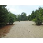
Wayne: This is the Wayne Desert.

Wayne: wilson pond
- add
your
Submit your own pictures of this town and show them to the world
- OSM Map
- General Map
- Google Map
- MSN Map
Population change since 2000: +6.9%
 |
| Males: 600 | |
| Females: 589 |
| Median resident age: | 49.1 years |
| Maine median age: | 43.0 years |
Zip codes: 04284.
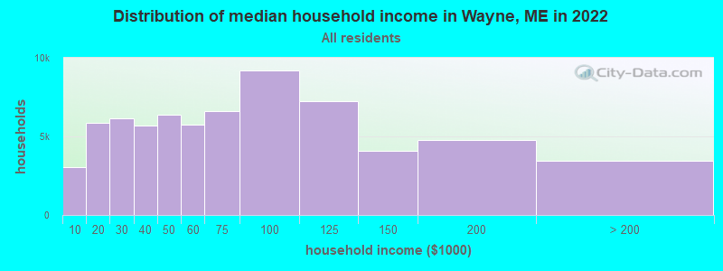
| Wayne: | $78,683 |
| ME: | $69,543 |
Estimated per capita income in 2022: $52,234 (it was $26,015 in 2000)
Wayne town income, earnings, and wages data
Estimated median house or condo value in 2022: $342,263 (it was $125,900 in 2000)
| Wayne: | $342,263 |
| ME: | $290,600 |
Mean prices in 2022: all housing units: $236,573; detached houses: $257,878; townhouses or other attached units: $279,624; in 2-unit structures: $165,218; in 3-to-4-unit structures: $152,679; in 5-or-more-unit structures: $182,239; mobile homes: $91,490
Detailed information about poverty and poor residents in Wayne, ME


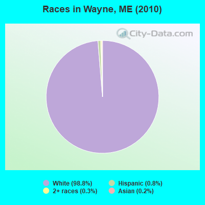
- 1,17598.8%White alone
- 90.8%Hispanic
- 30.3%Two or more races
- 20.2%Asian alone
Races in Wayne detailed stats: ancestries, foreign born residents, place of birth
According to our research of Maine and other state lists, there were 2 registered sex offenders living in Wayne, Maine as of April 27, 2024.
The ratio of all residents to sex offenders in Wayne is 595 to 1.
The ratio of registered sex offenders to all residents in this city is near the state average.
 Recent articles from our blog. Our writers, many of them Ph.D. graduates or candidates, create easy-to-read articles on a wide variety of topics.

 | Mass shooting in Lewiston (161 replies) |
| Maine weather thread (3207 replies) |
| Bill submitted to allow Maine gun owners to carry concealed without permit (296 replies) |
| Constitutional Carry Enacted (102 replies) |
| Bangor to Declare War? (76 replies) |
| Will a bear eat me if I move to Maine? (60 replies) |
Latest news from Wayne, ME collected exclusively by city-data.com from local newspapers, TV, and radio stations
Ancestries: English (32.7%), Irish (13.5%), French (12.4%), German (10.4%), Scottish (8.1%), French Canadian (6.1%).
Current Local Time: EST time zone
Incorporated on 02/12/1798
Elevation: 291 feet
Land area: 19.2 square miles.
Population density: 62 people per square mile (very low).
23 residents are foreign born (1.0% Europe, 0.5% North America).
| This town: | 2.1% |
| Maine: | 2.9% |
| Wayne town: | 1.5% ($1,937) |
| Maine: | 1.5% ($1,417) |
Nearest city with pop. 50,000+: Portland, ME  (48.5 miles , pop. 64,249).
Nearest city with pop. 200,000+: Boston, MA (149.6 miles , pop. 589,141).
Nearest city with pop. 1,000,000+: Bronx, NY (310.5 miles , pop. 1,332,650).
Nearest cities:
), ), ), ), Latitude: 44.35 N, Longitude: 70.06 W
Area code commonly used in this area: 207

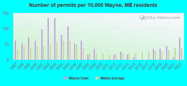
Single-family new house construction building permits:
- 2022: 8 buildings, average cost: $250,000
- 2021: 1 building, cost: $180,000
- 2020: 5 buildings, average cost: $208,800
- 2019: 4 buildings, average cost: $208,800
- 2018: 4 buildings, average cost: $208,800
- 2015: 1 building, cost: $210,000
- 2014: 2 buildings, average cost: $210,000
- 2013: 3 buildings, average cost: $156,700
- 2012: 2 buildings, average cost: $172,500
- 2009: 4 buildings, average cost: $196,300
- 2008: 2 buildings, average cost: $199,000
- 2007: 7 buildings, average cost: $344,300
- 2006: 6 buildings, average cost: $221,200
- 2005: 12 buildings, average cost: $152,900
- 2004: 9 buildings, average cost: $191,100
- 2003: 15 buildings, average cost: $115,100
- 2002: 15 buildings, average cost: $90,800
- 2001: 11 buildings, average cost: $95,200
- 2000: 7 buildings, average cost: $111,900
- 1999: 8 buildings, average cost: $77,500
- 1998: 6 buildings, average cost: $81,700
- 1997: 7 buildings, average cost: $65,100

| Here: | 3.6% |
| Maine: | 3.4% |


- Educational services (20.4%)
- Health care (12.5%)
- Professional, scientific, technical services (8.6%)
- Public administration (7.9%)
- Construction (6.1%)
- Agriculture, forestry, fishing & hunting (3.2%)
- Utilities (3.0%)

- Educational services (14.3%)
- Construction (11.4%)
- Public administration (9.6%)
- Professional, scientific, technical services (7.9%)
- Health care (5.7%)
- Agriculture, forestry, fishing & hunting (5.0%)
- Paper (3.6%)

- Educational services (26.4%)
- Health care (19.3%)
- Professional, scientific, technical services (9.3%)
- Public administration (6.1%)
- Utilities (3.2%)
- Real estate & rental & leasing (2.9%)
- Accommodation & food services (2.5%)

- Preschool, kindergarten, elementary, and middle school teachers (9.6%)
- Other management occupations, except farmers and farm managers (6.4%)
- Other sales and related occupations, including supervisors (5.5%)
- Counselors, social workers, and other community and social service specialists (4.8%)
- Computer specialists (3.4%)
- Other office and administrative support workers, including supervisors (3.4%)
- Physicians and surgeons (3.0%)

- Other management occupations, except farmers and farm managers (7.5%)
- Computer specialists (5.4%)
- Preschool, kindergarten, elementary, and middle school teachers (4.3%)
- Other sales and related occupations, including supervisors (4.3%)
- Top executives (3.9%)
- Physicians and surgeons (3.9%)
- Teachers, secondary school (3.2%)

- Preschool, kindergarten, elementary, and middle school teachers (15.0%)
- Counselors, social workers, and other community and social service specialists (6.8%)
- Other sales and related occupations, including supervisors (6.8%)
- Other management occupations, except farmers and farm managers (5.4%)
- Other office and administrative support workers, including supervisors (5.0%)
- Registered nurses (4.6%)
- Other teachers, instructors, education, training, and library occupations (3.2%)
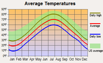
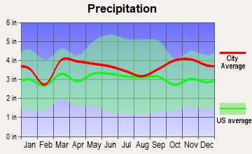
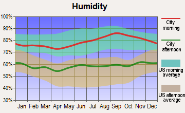
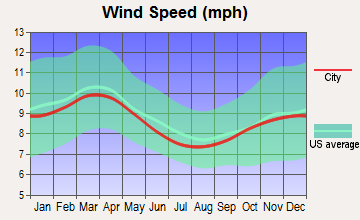
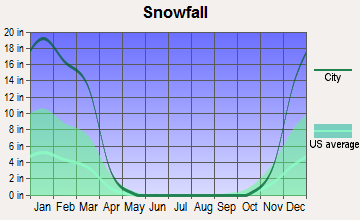
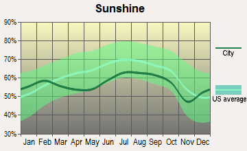
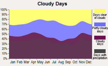
Average climate in Wayne, Maine
Based on data reported by over 4,000 weather stations
(lower is better)
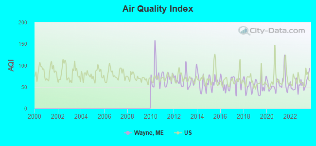
Air Quality Index (AQI) level in 2023 was 63.3. This is about average.
| City: | 63.3 |
| U.S.: | 72.6 |

Nitrogen Dioxide (NO2) [ppb] level in 2019 was 2.80. This is significantly better than average. Closest monitor was 12.3 miles away from the city center.
| City: | 2.80 |
| U.S.: | 5.11 |
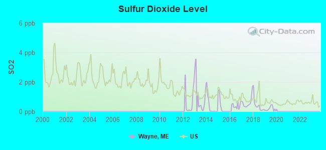
Sulfur Dioxide (SO2) [ppb] level in 2019 was 0.185. This is significantly better than average. Closest monitor was 10.3 miles away from the city center.
| City: | 0.185 |
| U.S.: | 1.515 |
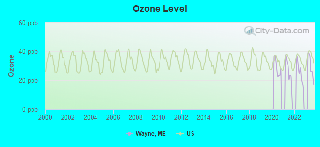
Ozone [ppb] level in 2023 was 29.5. This is about average. Closest monitor was 12.3 miles away from the city center.
| City: | 29.5 |
| U.S.: | 33.3 |
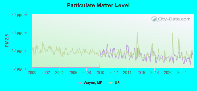
Particulate Matter (PM2.5) [µg/m3] level in 2023 was 5.89. This is better than average. Closest monitor was 13.6 miles away from the city center.
| City: | 5.89 |
| U.S.: | 8.11 |
Earthquake activity:
Wayne-area historical earthquake activity is significantly above Maine state average. It is 76% smaller than the overall U.S. average.On 4/20/2002 at 10:50:47, a magnitude 5.3 (5.3 ML, Depth: 3.0 mi, Class: Moderate, Intensity: VI - VII) earthquake occurred 180.1 miles away from the city center
On 10/16/2012 at 23:12:25, a magnitude 4.7 (4.7 ML, Depth: 10.0 mi, Class: Light, Intensity: IV - V) earthquake occurred 60.0 miles away from Wayne center
On 4/20/2002 at 10:50:47, a magnitude 5.2 (5.2 MB, 4.2 MS, 5.2 MW, 5.0 MW) earthquake occurred 181.1 miles away from the city center
On 10/7/1983 at 10:18:46, a magnitude 5.3 (5.1 MB, 5.3 LG, 5.1 ML) earthquake occurred 214.4 miles away from Wayne center
On 1/19/1982 at 00:14:42, a magnitude 4.7 (4.5 MB, 4.7 MD, 4.5 LG) earthquake occurred 96.8 miles away from Wayne center
On 2/26/1999 at 03:38:43, a magnitude 3.8 (3.8 LG, Depth: 2.0 mi, Class: Light, Intensity: II - III) earthquake occurred 28.0 miles away from Wayne center
Magnitude types: regional Lg-wave magnitude (LG), body-wave magnitude (MB), duration magnitude (MD), local magnitude (ML), surface-wave magnitude (MS), moment magnitude (MW)
Natural disasters:
The number of natural disasters in Kennebec County (21) is greater than the US average (15).Major Disasters (Presidential) Declared: 16
Emergencies Declared: 4
Causes of natural disasters: Floods: 13, Storms: 11, Snows: 5, Hurricanes: 3, Heavy Rains: 2, Blizzard: 1, Ice Storm: 1, Snowfall: 1, Wind: 1, Other: 2 (Note: some incidents may be assigned to more than one category).
Hospitals and medical centers near Wayne:
- HERITAGE REHAB AND LIVING CTR (Nursing Home, about 6 miles away; WINTHROP, ME)
- KENNEBEC KIDNEY CENTER (Dialysis Facility, about 13 miles away; AUGUSTA, ME)
- KENNEBEC VALLEY MEDICAL CENTER (Hospital, about 14 miles away; AUGUSTA, ME)
- VICTORIAN VILLA NURSING HOME (Nursing Home, about 15 miles away; CANTON, ME)
- RIVERVIEW PSYCHIATRIC CENTER (Hospital, about 15 miles away; AUGUSTA, ME)
- SUPPORTIVE LIVING SYSTEMS INC (Home Health Center, about 15 miles away; AUGUSTA, ME)
- MAINE GENERAL REHAB AND NURSING AT GLENRIDGE (Nursing Home, about 15 miles away; AUGUSTA, ME)
Colleges/universities with over 2000 students nearest to Wayne:
- University of Maine at Augusta (about 13 miles; Augusta, ME; Full-time enrollment: 3,204)
- University of Maine at Farmington (about 23 miles; Farmington, ME; FT enrollment: 2,036)
- Saint Joseph's College of Maine (about 42 miles; Standish, ME; FT enrollment: 2,010)
- University of Southern Maine (about 49 miles; Portland, ME; FT enrollment: 6,647)
- Southern Maine Community College (about 50 miles; South Portland, ME; FT enrollment: 4,666)
- University of New England (about 64 miles; Biddeford, ME; FT enrollment: 4,539)
- Husson University (about 71 miles; Bangor, ME; FT enrollment: 2,421)
Public elementary/middle school in Wayne:
- WAYNE ELEMENTARY SCHOOL (Location: 48 POND ROAD, Grades: KG-5)
Points of interest:
Notable locations in Wayne: Wayne Volunteer Fire Department Village Station (A), Wayne Volunteer Fire Department North Wayne Station (B). Display/hide their locations on the map
Cemetery: Wing Cemetery (1). Display/hide its location on the map
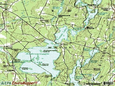
Lakes and reservoirs: Androscoggin Lake (A), Dexter Pond (B), Pickerel Pond (C), Pocasset Lake (D). Display/hide their locations on the map
Streams, rivers, and creeks: Hales Brook (A), Bog Brook (B). Display/hide their locations on the map
Birthplace of: George K. Broomhall - Union Army General.
Drinking water stations with addresses in Wayne and their reported violations in the past:
CAMP ANDROSCOGGIN JR-SR (Population served: 320, Groundwater):Past health violations:LADD RECREATION AREA (Population served: 40, Groundwater):Past monitoring violations:
- MCL, Monthly (TCR) - In JUL-2011, Contaminant: Coliform. Follow-up actions: St Public Notif requested (JUL-18-2011), St Formal NOV issued (JUL-18-2011), St Public Notif received (AUG-15-2011), St Compliance achieved (SEP-12-2011)
- One routine major monitoring violation
- 2 regular monitoring violations
Past monitoring violations:
- 9 routine major monitoring violations
| This town: | 2.3 people |
| Maine: | 2.3 people |
| This town: | 69.6% |
| Whole state: | 62.9% |
| This town: | 8.9% |
| Whole state: | 9.4% |
Likely homosexual households (counted as self-reported same-sex unmarried-partner households)
- Lesbian couples: 0.6% of all households
- Gay men: 0.0% of all households
| This town: | 5.9% |
| Whole state: | 10.9% |
| This town: | 1.7% |
| Whole state: | 4.1% |
For population 15 years and over in Wayne:
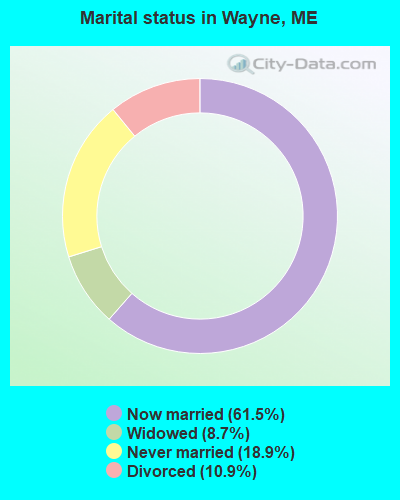
- Never married: 18.9%
- Now married: 61.5%
- Separated: 0.0%
- Widowed: 8.7%
- Divorced: 10.9%
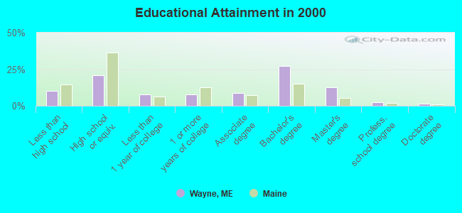
For population 25 years and over in Wayne:
- High school or higher: 89.6%
- Bachelor's degree or higher: 43.9%
- Graduate or professional degree: 16.8%
- Unemployed: 2.9%
- Mean travel time to work (commute): 26.5 minutes
| Here: | 11.3 |
| Maine average: | 11.2 |
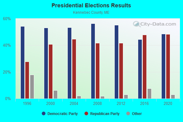
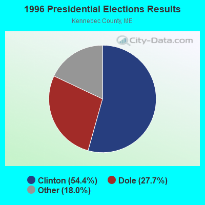
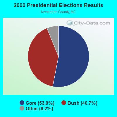

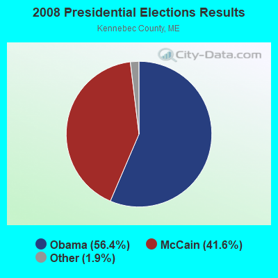
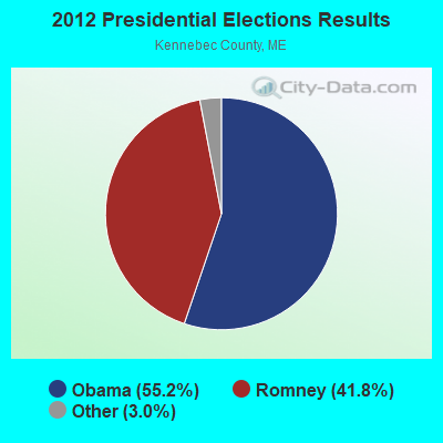

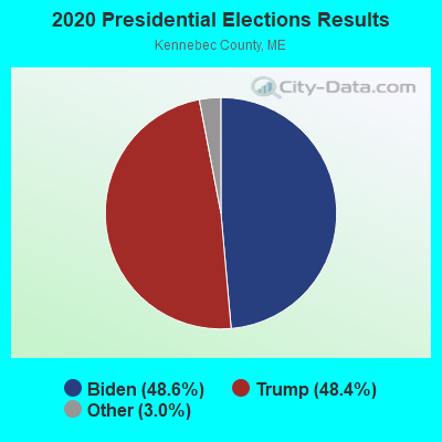
Graphs represent county-level data. Detailed 2008 Election Results
Religion statistics for Wayne, ME (based on Kennebec County data)
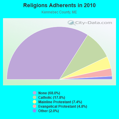
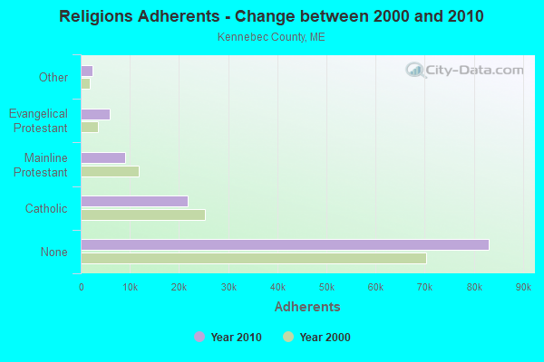
| Religion | Adherents | Congregations |
|---|---|---|
| Catholic | 21,758 | 11 |
| Mainline Protestant | 8,999 | 60 |
| Evangelical Protestant | 5,829 | 56 |
| Other | 2,466 | 17 |
| None | 83,099 | - |
Food Environment Statistics:
| This county: | 1.99 / 10,000 pop. |
| State: | 2.80 / 10,000 pop. |
| This county: | 0.17 / 10,000 pop. |
| Maine: | 0.14 / 10,000 pop. |
| This county: | 1.41 / 10,000 pop. |
| State: | 2.20 / 10,000 pop. |
| Kennebec County: | 6.38 / 10,000 pop. |
| Maine: | 5.75 / 10,000 pop. |
| Kennebec County: | 8.70 / 10,000 pop. |
| Maine: | 11.02 / 10,000 pop. |
| This county: | 8.6% |
| Maine: | 8.2% |
| This county: | 28.2% |
| State: | 25.0% |
Strongest AM radio stations in Wayne:
- WFAU (1280 AM; 5 kW; GARDINER, ME; Owner: CAPSTAR TX LIMITED PARTNERSHIP)
- WTME (780 AM; 10 kW; RUMFORD, ME; Owner: MOUNTAIN VALLEY BROADCASTING, INC.)
- WSKW (1160 AM; 10 kW; SKOWHEGAN, ME; Owner: MOUNTAIN WIRELESS, INCORPORATED)
- WLAM (1470 AM; 5 kW; LEWISTON, ME; Owner: RADIO PARTNERS OF MAINE, L.P.)
- WMTW (870 AM; 10 kW; GORHAM, ME; Owner: RADIO PARTNERS OF MAINE, L.P.)
- WGAN (560 AM; 5 kW; PORTLAND, ME; Owner: SAGA COMMUNICATIONS OF NEW ENGLAND, LLC)
- WMDR (1340 AM; 1 kW; AUGUSTA, ME; Owner: LIGHT OF LIFE MINISTRIES, INC.)
- WRKO (680 AM; 50 kW; BOSTON, MA; Owner: ENTERCOM BOSTON LICENSE, LLC)
- WEZW (1400 AM; 1 kW; AUGUSTA, ME; Owner: CITADEL BROADCASTING COMPANY)
- WEEI (850 AM; 50 kW; BOSTON, MA; Owner: ENTERCOM BOSTON LICENSE, LLC)
- WCNM (1240 AM; 1 kW; LEWISTON, ME; Owner: CHRISTIAN FAMILY RADIO, INC.)
- WBZ (1030 AM; 50 kW; BOSTON, MA; Owner: INFINITY BROADCASTING OPERATIONS, INC.)
- WCRN (830 AM; 50 kW; WORCESTER, MA; Owner: CARTER BROADCASTING CORPORATION)
Strongest FM radio stations in Wayne:
- WCYI (93.9 FM; LEWISTON, ME; Owner: CITADEL BROADCASTING COMPANY)
- WPKQ (103.7 FM; NORTH CONWAY, NH; Owner: CITADEL BROADCASTING COMPANY)
- WHOM (94.9 FM; MT. WASHINGTON, NH; Owner: CITADEL BROADCASTING COMPANY)
- WABK-FM (104.3 FM; GARDINER, ME; Owner: CAPSTAR TX LIMITED PARTNERSHIP)
- WLOB-FM (96.3 FM; RUMFORD, ME; Owner: ATLANTIC COAST RADIO, LLC)
- WTOS-FM (105.1 FM; SKOWHEGAN, ME; Owner: CAPSTAR TX LIMITED PARTNERSHIP)
- WKCG (101.3 FM; AUGUSTA, ME; Owner: CAPSTAR TX LIMITED PARTNERSHIP)
- WTBM (100.7 FM; MEXICO, ME; Owner: MOUNTAIN VALLEY BROADCASTING, INC.)
- WBLM (102.9 FM; PORTLAND, ME; Owner: CITADEL BROADCASTING COMPANY)
- WMEA (90.1 FM; PORTLAND, ME; Owner: MAINE PUBLIC BROADCASTING CORPORATION)
- WWWA (95.3 FM; WINSLOW, ME; Owner: LIGHT OF LIFE MINISTRIES, INC.)
- WMME-FM (92.3 FM; AUGUSTA, ME; Owner: CITADEL BROADCASTING COMPANY)
- WTHT (107.5 FM; LEWISTON, ME; Owner: RADIO PARTNERS OF MAINE, L.P.)
- WBCI (105.9 FM; BATH, ME; Owner: BLOUNT COMMUNICATIONS, INC.)
- WMEP (90.5 FM; CAMDEN, ME; Owner: MAINE PUBLIC BROADCASTING CORP.)
- WQSS (102.5 FM; CAMDEN, ME; Owner: CLEAR CHANNEL BROADCASTING LICENSES, INC.)
- WHQO (107.9 FM; SKOWHEGAN, ME; Owner: MOUNTAIN WIRELESS, INC.)
- WJBQ (97.9 FM; PORTLAND, ME; Owner: CITADEL BROADCASTING COMPANY)
- WMEK-FM (99.9 FM; AUBURN, ME; Owner: RADIO PARTNERS OF MAINE, L.P.)
- WKTJ-FM (99.3 FM; FARMINGTON, ME; Owner: FRANKLIN BROADCASTING CORPORATION)
TV broadcast stations around Wayne:
- WPFO (Channel 23; WATERVILLE, ME; Owner: CMCG PORTLAND LICENSE LLC)
- WCBB (Channel 10; AUGUSTA, ME; Owner: MAINE PUBLIC BROADCASTING CORP.)
- WGME-TV (Channel 13; PORTLAND, ME; Owner: WGME LICENSEE, LLC)
- WMTW-TV (Channel 8; POLAND SPRING, ME; Owner: WMTW BROADCAST GROUP, LLC)
- WCSH (Channel 6; PORTLAND, ME; Owner: PACIFIC AND SOUTHERN COMPANY, INC.)
- WPXT (Channel 51; PORTLAND, ME; Owner: HMW, INC.)
- W21BI (Channel 21; FARMINGTON, ME; Owner: TRINITY BROADCASTING NETWORK)
- WFYW-LP (Channel 69; FAIRFIELD/WATERVILLE, ME; Owner: THREE ANGELS BROADCASTING NETWORK, INC.)
- Wayne, Maine
- Fatal accident count12
- Vehicles involved in fatal accidents15
- Fatal accidents involving drunk persons:5
- Fatalities12
- Persons involved in fatal accidents22
- Pedestrians involved in fatal accidents0
- Maine average
- Fatal accident count1690
- Vehicles involved in fatal accidents2409
- Fatal accidents involving drunk persons707
- Fatalities1865
- Persons involved in fatal accidents3911
- Pedestrians involved in fatal accidents104
- National Bridge Inventory (NBI) Statistics
- 10Number of bridges
- 220ft / 67.0mTotal length
- 148,640Total average daily traffic
- 14,072Total average daily truck traffic
- 208,204Total future (year 2036) average daily traffic
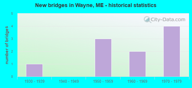
- New bridges - historical statistics
- 11930-1939
- 31950-1959
- 21960-1969
- 41970-1979
FCC Registered Amateur Radio Licenses:
7- Call Sign: KA1MVB, Licensee ID: L00229332, Grant Date: 12/05/1995, Expiration Date: 12/05/2005, Cancellation Date: 12/06/2007, Registrant: Duane R Crosby, Wayne, ME 04284
- Call Sign: N1EBR, Grant Date: 01/23/1996, Expiration Date: 01/23/2006, Cancellation Date: 01/24/2008, Registrant: Deborah R Crosby, Rfd 1 Box 2740, Wayne, ME 04284
- Call Sign: N1YJR, Licensee ID: L01204728, Grant Date: 10/20/2006, Expiration Date: 01/10/2017, Cancellation Date: 02/12/2019, Certifier: Gary W Carr, Registrant: Gary W Carr, 22 Berry Road, Wayne, ME 04284
- Call Sign: N1ZIU, Licensee ID: L00234452, Grant Date: 03/02/2017, Expiration Date: 05/29/2027, Certifier: Carroll Paradis, Registrant: Carroll Paradis, 607 Main St, Wayne, ME 04284
- Call Sign: W1IJW, Licensee ID: L00240777, Grant Date: 05/17/2000, Expiration Date: 08/07/2010, Cancellation Date: 08/08/2012, Registrant: Alexander F Smith, Rfd 1 Box 3323, Wayne, ME 04284
- Call Sign: KC1BSS, Licensee ID: L01860479, Grant Date: 03/29/2024, Expiration Date: 04/24/2034, Certifier: Steven M Booth, Registrant: Steven M Booth, 56 Mount Pisgah Rd, Wayne, ME 04284-3517
- Call Sign: KC1TYG, Licensee ID: L02740023, Grant Date: 01/04/2024, Expiration Date: 01/04/2034, Certifier: Mark N St John, Registrant: Mark N St John, Wayne, ME 04284
2003 - 2018 National Fire Incident Reporting System (NFIRS) incidents
- Fire incident types reported to NFIRS in Wayne, ME
- 7966.9%Structure Fires
- 2924.6%Outside Fires
- 86.8%Mobile Property/Vehicle Fires
- 21.7%Other
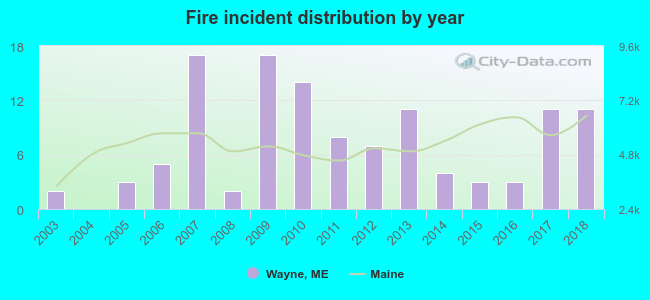 According to the data from the years 2003 - 2018 the average number of fire incidents per year is 7. The highest number of fires - 17 took place in 2007, and the least - 0 in 2004. The data has an increasing trend.
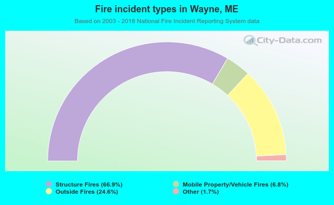 When looking into fire subcategories, the most incidents belonged to: Structure Fires (66.9%), and Outside Fires (24.6%).
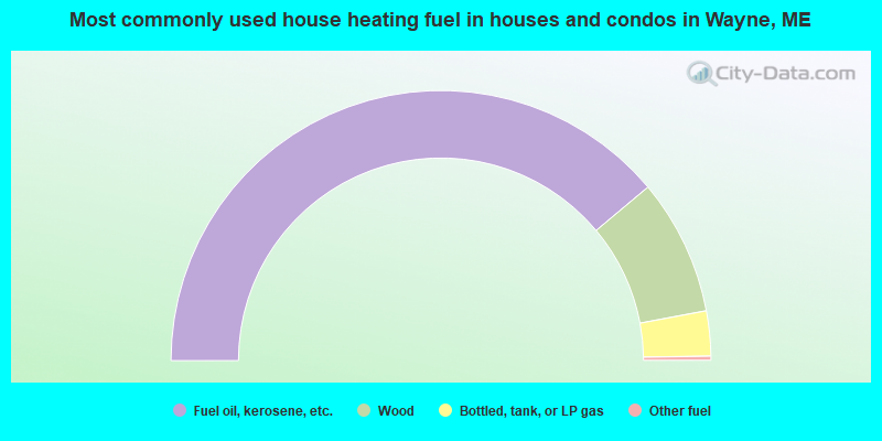
- 77.8%Fuel oil, kerosene, etc.
- 16.3%Wood
- 5.4%Bottled, tank, or LP gas
- 0.5%Other fuel
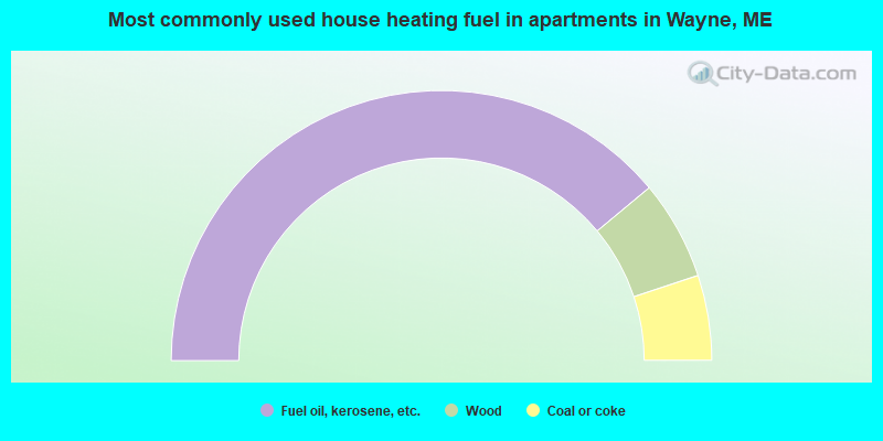
- 78.0%Fuel oil, kerosene, etc.
- 11.9%Wood
- 10.2%Coal or coke
Wayne compared to Maine state average:
- Unemployed percentage significantly below state average.
- Black race population percentage significantly below state average.
- Hispanic race population percentage below state average.
- Median age above state average.
- Foreign-born population percentage below state average.
- Renting percentage significantly below state average.
- Length of stay since moving in significantly above state average.
- Number of rooms per house significantly below state average.
- House age significantly below state average.
- Percentage of population with a bachelor's degree or higher above state average.

|
Total of 3 patent applications in 2008-2024.