West Adams, Colorado
Submit your own pictures of this place and show them to the world
- OSM Map
- General Map
- Google Map
- MSN Map

| Males: 155,483 | |
| Females: 154,926 |
| Median resident age: | 31.8 years |
| Colorado median age: | 34.3 years |
Zip code: 80260
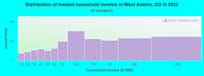
| West Adams: | $97,068 |
| CO: | $89,302 |
Estimated per capita income in 2022: $42,782 (it was $21,409 in 2000)
West Adams CCD income, earnings, and wages data
Estimated median house or condo value in 2022: $499,568 (it was $146,500 in 2000)
| West Adams: | $499,568 |
| CO: | $531,100 |
Mean prices in 2022: all housing units: $511,179; detached houses: $576,428; townhouses or other attached units: $387,990; in 2-unit structures: $511,676; in 3-to-4-unit structures: $417,982; in 5-or-more-unit structures: $303,466; mobile homes: $84,031; occupied boats, rvs, vans, etc.: $6,549
Detailed information about poverty and poor residents in West Adams, CO
Compare current foreclosures near West Adams, CO:
| Photo | Address | Area | Beds / Baths | Price | Details |
|---|---|---|---|---|---|

|
#1
Pawnee Dr
Boulder, CO 80303
|
1,416 sq. feet
|
2 baths 3 beds |
$910,000
|
show details |

|
#2
E 101st Pl
Commerce City, CO 80022
|
2,140 sq. feet
|
3 baths 4 beds |
show details | |

|
#3
E Alameda Ave Apt 22-106
Denver, CO 80247
|
1,019 sq. feet
|
2 baths 2 beds |
show details | |

|
#4
E Mississippi Ave Apt C2
Denver, CO 80247
|
1,142 sq. feet
|
2 baths 2 beds |
show details | |

|
#5
Forest Dr
Denver, CO 80241
|
990 sq. feet
|
1 baths 2 beds |
show details | |

|
#6
Chase Cir Apt 193
Arvada, CO 80003
|
800 sq. feet
|
1 baths 2 beds |
show details | |

|
#7
Sable St
Denver, CO 80239
|
1,230 sq. feet
|
2 baths 3 beds |
show details | |

|
#8
Washington St
Denver, CO 80241
|
2,310 sq. feet
|
3 baths 4 beds |
show details | |

|
#9
Richfield Cir
Commerce City, CO 80022
|
1,841 sq. feet
|
2 baths 3 beds |
show details | |

|
#10
Meade Way
Westminster, CO 80030
|
- sq. feet
|
2 baths 3 beds |
show details |
| Photo | Address | Area | Beds / Baths | Price | Details |
|---|---|---|---|---|---|

|
#11
Wolff St Unit H
Westminster, CO 80031
|
- sq. feet
|
1 baths 3 beds |
show details | |

|
#12
E Alaska Ave
Aurora, CO 80012
|
1,118 sq. feet
|
1 baths 2 beds |
show details | |

|
#13
E Ohio Pl
Aurora, CO 80012
|
1,390 sq. feet
|
2 baths 3 beds |
show details | |

|
#14
Sedalia St
Commerce City, CO 80022
|
2,138 sq. feet
|
2 baths 3 beds |
show details | |

|
#15
Jackson Pl
Denver, CO 80241
|
918 sq. feet
|
1 baths 3 beds |
show details | |

|
#16
S Galapago St
Englewood, CO 80110
|
1,040 sq. feet
|
2 baths 3 beds |
show details | |

|
#17
Newland St
Denver, CO 80214
|
1,178 sq. feet
|
2 baths 3 beds |
show details | |

|
#18
E 121st Ct
Denver, CO 80241
|
1,288 sq. feet
|
2 baths 3 beds |
show details | |

|
#19
Florence St
Aurora, CO 80010
|
725 sq. feet
|
1 baths 2 beds |
show details | |

|
#20
Newton St
Arvada, CO 80003
|
2,392 sq. feet
|
4 baths 4 beds |
show details |
| Photo | Address | Area | Beds / Baths | Price | Details |
|---|---|---|---|---|---|

|
#21
E Evans Ave
Aurora, CO 80014
|
3,152 sq. feet
|
4 baths 4 beds |
show details | |

|
#22
Eagle St
Denver, CO 80239
|
936 sq. feet
|
2 baths 3 beds |
show details | |

|
#23
Quintero St
Commerce City, CO 80022
|
2,633 sq. feet
|
2 baths 3 beds |
show details | |

|
#24
Mockingbird St
Brighton, CO 80601
|
1,240 sq. feet
|
3 baths 2 beds |
show details | |

|
#25
Krameria St
Denver, CO 80220
|
947 sq. feet
|
2 baths 2 beds |
show details | |

|
#26
W Dartmouth Ave
Denver, CO 80227
|
1,351 sq. feet
|
3 baths 3 beds |
show details | |

|
#27
Mulberry Cir
Broomfield, CO 80020
|
1,216 sq. feet
|
1 baths 3 beds |
show details | |

|
#28
Xavier St
Broomfield, CO 80020
|
1,499 sq. feet
|
3 baths 3 beds |
show details | |

|
#29
W 74th Ave
Arvada, CO 80007
|
1,926 sq. feet
|
2 baths 4 beds |
show details | |

|
#30
W 71st Pl
Westminster, CO 80030
|
1,738 sq. feet
|
2 baths 3 beds |
show details |
| Photo | Address | Area | Beds / Baths | Price | Details |
|---|---|---|---|---|---|

|
#31
Shenandoah Way
Brighton, CO 80603
|
1,540 sq. feet
|
2 baths 4 beds |
show details | |

|
#32
Zenobia Pl
Westminster, CO 80030
|
1,472 sq. feet
|
1 baths 4 beds |
show details | |

|
#33
Marion St
Denver, CO 80241
|
2,539 sq. feet
|
3 baths 4 beds |
show details | |

|
#34
S Newark Ct
Aurora, CO 80012
|
1,296 sq. feet
|
2 baths 2 beds |
show details | |

|
#35
E 125th Ave
Denver, CO 80241
|
990 sq. feet
|
2 baths 2 beds |
show details | |

|
#36
Leyden Ln
Commerce City, CO 80022
|
720 sq. feet
|
1 baths 2 beds |
show details | |

|
#37
E 84th Dr
Denver, CO 80229
|
1,163 sq. feet
|
1 baths 3 beds |
show details | |

|
#38
W Alaska Pl
Denver, CO 80219
|
836 sq. feet
|
1 baths 3 beds |
show details | |

|
#39
S Depew St
Denver, CO 80226
|
1,097 sq. feet
|
1 baths 4 beds |
show details | |

|
#40
Beech Ct
Golden, CO 80401
|
2,088 sq. feet
|
3 baths 4 beds |
show details |
| Photo | Address | Area | Beds / Baths | Price | Details |
|---|---|---|---|---|---|

|
#41
W Nevada Pl
Denver, CO 80219
|
973 sq. feet
|
1 baths 3 beds |
show details | |

|
#42
W Alaska Pl
Denver, CO 80219
|
1,646 sq. feet
|
2 baths 2 beds |
show details | |

|
#43
Jackson Ct
Denver, CO 80233
|
1,424 sq. feet
|
2 baths 3 beds |
show details | |

|
#44
Erie St
Denver, CO 80221
|
2,000 sq. feet
|
2 baths 4 beds |
show details | |

|
#45
E Alaska Ave
Aurora, CO 80012
|
2,080 sq. feet
|
2 baths 2 beds |
show details | |

|
#46
Grace Pl
Denver, CO 80221
|
900 sq. feet
|
2 baths 3 beds |
show details | |

|
#47
E 107th Ave
Denver, CO 80233
|
1,452 sq. feet
|
2 baths 3 beds |
show details | |

|
#48
Lafayette St
Denver, CO 80233
|
1,276 sq. feet
|
2 baths 4 beds |
show details | |

|
#49
W Adriatic Pl
Englewood, CO 80110
|
1,104 sq. feet
|
1 baths 3 beds |
show details | |

|
Check over 1 million property listings on Foreclosure.com!
|
browse all offers | |||

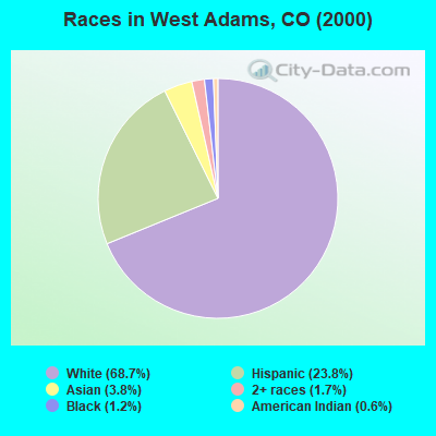
- 178,49168.7%White alone
- 61,75623.8%Hispanic
- 9,8273.8%Asian alone
- 4,3291.7%Two or more races
- 3,1771.2%Black alone
- 1,6070.6%American Indian alone
- 2270.09%Other race alone
- 2140.08%Native Hawaiian and Other
Pacific Islander alone
 Recent articles from our blog. Our writers, many of them Ph.D. graduates or candidates, create easy-to-read articles on a wide variety of topics.
Current Local Time: MST time zone
Land area: 74.5 square miles.
Population density: 4,166 people per square mile (average).

| West Adams CCD: | 0.8% ($1,182) |
| Colorado: | 0.7% ($1,132) |
Nearest city with pop. 1,000,000+: Phoenix, AZ  (588.7 miles , pop. 1,321,045).
Nearest cities:
), ), ), Latitude: 39.87 N, Longitude: 104.99 W

| Here: | 3.6% |
| Colorado: | 3.2% |
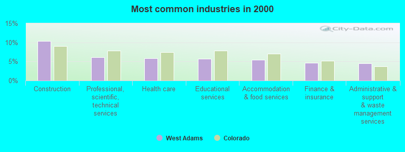
- Construction (10.4%)
- Professional, scientific, technical services (6.1%)
- Health care (5.9%)
- Educational services (5.7%)
- Accommodation & food services (5.5%)
- Finance & insurance (4.6%)
- Administrative & support & waste management services (4.5%)
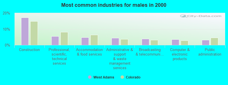
- Construction (17.1%)
- Professional, scientific, technical services (5.5%)
- Accommodation & food services (4.8%)
- Administrative & support & waste management services (4.5%)
- Broadcasting & telecommunications (3.9%)
- Computer & electronic products (3.6%)
- Public administration (3.3%)
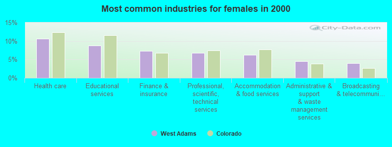
- Health care (10.6%)
- Educational services (8.8%)
- Finance & insurance (7.3%)
- Professional, scientific, technical services (6.8%)
- Accommodation & food services (6.2%)
- Administrative & support & waste management services (4.5%)
- Broadcasting & telecommunications (4.0%)
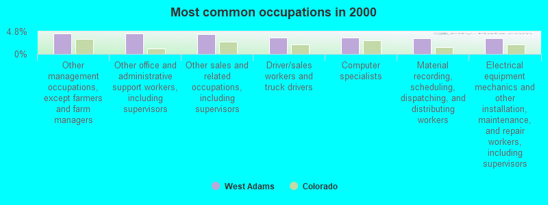
- Other management occupations, except farmers and farm managers (4.4%)
- Other office and administrative support workers, including supervisors (4.4%)
- Other sales and related occupations, including supervisors (4.3%)
- Driver/sales workers and truck drivers (3.5%)
- Computer specialists (3.5%)
- Material recording, scheduling, dispatching, and distributing workers (3.4%)
- Electrical equipment mechanics and other installation, maintenance, and repair workers, including supervisors (3.3%)
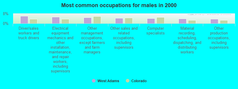
- Driver/sales workers and truck drivers (6.1%)
- Electrical equipment mechanics and other installation, maintenance, and repair workers, including supervisors (5.4%)
- Other management occupations, except farmers and farm managers (4.9%)
- Other sales and related occupations, including supervisors (4.3%)
- Computer specialists (4.2%)
- Material recording, scheduling, dispatching, and distributing workers (3.8%)
- Other production occupations, including supervisors (3.7%)
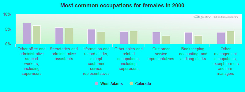
- Other office and administrative support workers, including supervisors (7.1%)
- Secretaries and administrative assistants (5.6%)
- Information and record clerks, except customer service representatives (4.9%)
- Other sales and related occupations, including supervisors (4.2%)
- Customer service representatives (4.1%)
- Bookkeeping, accounting, and auditing clerks (3.9%)
- Other management occupations, except farmers and farm managers (3.9%)
Average climate in West Adams, Colorado
Based on data reported by over 4,000 weather stations


(lower is better)
Air Quality Index (AQI) level in 2023 was 123. This is significantly worse than average.
| City: | 123 |
| U.S.: | 73 |
Carbon Monoxide (CO) [ppm] level in 2023 was 0.277. This is about average. Closest monitor was 3.4 miles away from the city center.
| City: | 0.277 |
| U.S.: | 0.251 |
Nitrogen Dioxide (NO2) [ppb] level in 2023 was 15.2. This is significantly worse than average. Closest monitor was 3.4 miles away from the city center.
| City: | 15.2 |
| U.S.: | 5.1 |
Sulfur Dioxide (SO2) [ppb] level in 2023 was 0.894. This is significantly better than average. Closest monitor was 3.4 miles away from the city center.
| City: | 0.894 |
| U.S.: | 1.515 |
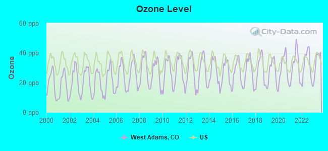
Ozone [ppb] level in 2023 was 34.1. This is about average. Closest monitor was 3.4 miles away from the city center.
| City: | 34.1 |
| U.S.: | 33.3 |
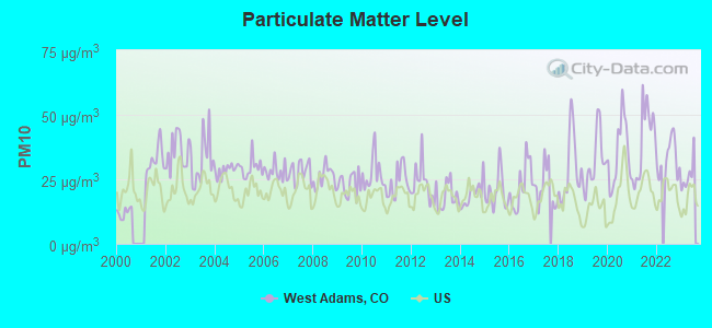
Particulate Matter (PM10) [µg/m3] level in 2023 was 26.6. This is worse than average. Closest monitor was 2.4 miles away from the city center.
| City: | 26.6 |
| U.S.: | 19.2 |
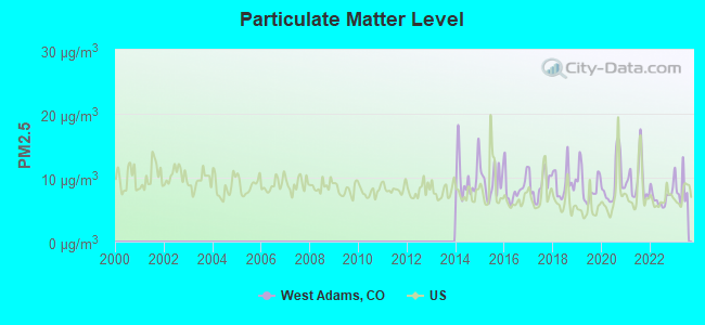
Particulate Matter (PM2.5) [µg/m3] level in 2023 was 8.48. This is about average. Closest monitor was 4.3 miles away from the city center.
| City: | 8.48 |
| U.S.: | 8.11 |
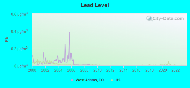
Lead (Pb) [µg/m3] level in 2009 was 0.00502. This is significantly better than average. Closest monitor was 3.4 miles away from the city center.
| City: | 0.00502 |
| U.S.: | 0.00931 |
Tornado activity:
West Adams-area historical tornado activity is above Colorado state average. It is 30% greater than the overall U.S. average.
On 6/15/1988, a category F3 (max. wind speeds 158-206 mph) tornado 10.5 miles away from the West Adams place center injured 7 people and caused between $5,000,000 and $50,000,000 in damages.
On 5/18/1975, a category F3 tornado 14.8 miles away from the place center .
Earthquake activity:
West Adams-area historical earthquake activity is significantly above Colorado state average. It is 709% greater than the overall U.S. average.On 8/18/1959 at 06:37:13, a magnitude 7.7 (7.7 UK, Class: Major, Intensity: VIII - XII) earthquake occurred 435.0 miles away from the city center, causing $26,000,000 total damage
On 10/18/1984 at 15:30:23, a magnitude 5.5 (5.4 MB, 5.1 MS, 5.5 ML, Class: Moderate, Intensity: VI - VII) earthquake occurred 176.9 miles away from West Adams center
On 10/28/1983 at 14:06:06, a magnitude 7.3 (6.2 MB, 7.3 MS, 7.0 MW) earthquake occurred 537.8 miles away from the city center, causing 2 deaths (2 shaking deaths) and 3 injuries, causing $15,000,000 total damage
On 8/23/2011 at 05:46:18, a magnitude 5.3 (5.3 MW, Depth: 2.5 mi) earthquake occurred 195.1 miles away from the city center
On 3/28/1975 at 02:31:05, a magnitude 6.2 (6.1 MB, 6.0 MS, 6.2 ML, Class: Strong, Intensity: VII - IX) earthquake occurred 417.8 miles away from West Adams center
On 8/10/2005 at 22:08:22, a magnitude 5.0 (5.0 MW, Depth: 3.1 mi) earthquake occurred 202.7 miles away from the city center
Magnitude types: body-wave magnitude (MB), local magnitude (ML), surface-wave magnitude (MS), moment magnitude (MW)
Natural disasters:
The number of natural disasters in Adams County (11) is smaller than the US average (15).Major Disasters (Presidential) Declared: 6
Emergencies Declared: 4
Causes of natural disasters: Floods: 6, Storms: 5, Landslides: 3, Mudslides: 3, Snows: 2, Tornadoes: 2, Fire: 1, Heavy Rain: 1, Hurricane: 1, Snowstorm: 1, Other: 1 (Note: some incidents may be assigned to more than one category).
Hospitals and medical centers near West Adams:
- ALPINE LIVING CENTER (Nursing Home, about 1 miles away; THORNTON, CO)
- COLUMBIA NORTH SUBURBAN REHAB HOSPITAL (Hospital, about 1 miles away; THORNTON, CO)
- NORTH SUBURBAN MEDICAL CENTER Acute Care Hospitals (about 1 miles away; THORNTON, CO)
- THORNTON DIALYSIS (DVA) (Dialysis Facility, about 2 miles away; THORNTON, CO)
- THORNTON KIDNEY CENTER LLC (ARA) (Dialysis Facility, about 2 miles away; THORNTON, CO)
- NORTH VALLEY REHABILITATION HOSPITAL-NF (Nursing Home, about 2 miles away; THORNTON, CO)
- VISTA VIEW CARE CENTER (Nursing Home, about 2 miles away; THORNTON, CO)
Amtrak stations near West Adams:
- 9 miles: DENVER (1701 WYNKOOP ST.) . Services: ticket office, fully wheelchair accessible, enclosed waiting area, public restrooms, public payphones, full-service food facilities and snack bar, paid short-term parking, paid long-term parking, call for car rental service, taxi stand, public transit connection.
- 18 miles: DENVER INTERNATIONAL AP'T (DENVER, DENVER INTERNATIONAL AIRPORT) - Bus Station . Services: enclosed waiting area, public restrooms, public payphones, full-service food facilities, paid short-term parking, paid long-term parking, car rental agency, taxi stand, public transit connection.
- 20 miles: BOULDER (4401 N. BROADWAY) - Bus Station . Services: enclosed waiting area, public payphones, snack bar.
Colleges/universities with over 2000 students nearest to West Adams:
- Front Range Community College (about 4 miles; Westminster, CO; Full-time enrollment: 14,756)
- Regis University (about 7 miles; Denver, CO; FT enrollment: 6,975)
- University of Colorado Denver (about 9 miles; Denver, CO; FT enrollment: 14,727)
- Metropolitan State University of Denver (about 10 miles; Denver, CO; FT enrollment: 17,242)
- Community College of Denver (about 10 miles; Denver, CO; FT enrollment: 7,329)
- Emily Griffith Technical College (about 10 miles; Denver, CO; FT enrollment: 2,460)
- University of Denver (about 13 miles; Denver, CO; FT enrollment: 9,621)
Points of interest:
Notable locations in West Adams: The Plaza at Westminster (A), The Golf Courses at Hyland Hills (B), Perl Mack Manor (C), Hyland Hills Municipal Golf Course (D), The Ranch Country Club (E), Thorncreek Municipal Golf Course (F), Washington Square Business Center (G), Broadlands Golf Course (H), Water World (I), Thornton High School Football Stadium (J), Skyview Academy High School Football Stadium (K), Legacy Ridge Golf Course (L), Thorncreek Golf Course (M), Federal Heights Fire Department (N), Westminster Fire Department Station 1 (O), Westminster Municipal Court (P), Westminster Fire Department Station 2 (Q), Westminster Fire Department Station 4 (R), Flight for Life Colorado Westminster (S), Westminster Public Library Irving Street Branch (T). Display/hide their locations on the map
Shopping Centers: Merchants Park Shopping Center (1), Northglenn Mall Shopping Center (2), Broomfield Plaza Shopping Center (3), Colorado Marketplace Shopping Center (4), Huron Plaza Shopping Center (5), Mission Trace At Thorton Shopping Center (6), Pinnacle At Horizon Shopping Center (7), Sheridan Crossing Shopping Center (8), Sunrise Village Shopping Center (9). Display/hide their locations on the map
Churches in West Adams include: Thrive Church Federal Heights Campus (A), Harvest Worship Center (B), Grace Community Church (C), Love Outreach Pentecostal Church (D), Kingdom Hall of Jehovah's Witnesses (E), North Federal Baptist Church (F), Our Lady of Visitation Church (G), Saint Mark Catholic Church (H), Agape Bible Church (I). Display/hide their locations on the map
Cemeteries: Broomfield County Commons Cemetery (1), Wesley Chapel Cemetery (2), Highland Memorial Gardens (3). Display/hide their locations on the map
Lakes and reservoirs: Grasmer Lake (A), Mayham Lake (B), Walter Long Reservoir (C), Ohio Lake Reservoir (D), Sunny Acres Reservoir (E), Vogler Reservoir Number 1 (F), Kalcevic Reservoir (G), Le Gault Reservoir (H). Display/hide their locations on the map
Creek: Little Dry Creek (A). Display/hide its location on the map
Parks in West Adams include: Woodglen Park (1), Berkeley Hills Park (2), Wolff Run Park (3), Windsor Park (4), Columbine Meadows Park (5), The Ranch Open Space (6), Tennyson Knolls Park (7), Stonehocker Park (8), Riverdale Park (9). Display/hide their locations on the map
| This place: | 2.7 people |
| Colorado: | 2.5 people |
| This place: | 68.7% |
| Whole state: | 63.9% |
| This place: | 8.0% |
| Whole state: | 6.5% |
Likely homosexual households (counted as self-reported same-sex unmarried-partner households)
- Lesbian couples: 0.5% of all households
- Gay men: 0.3% of all households
| This place: | 6.5% |
| Whole state: | 9.3% |
| This place: | 3.0% |
| Whole state: | 4.1% |
People in group quarters in West Adams in 2010:
- 861 people in nursing facilities/skilled-nursing facilities
- 23 people in residential treatment centers for adults
- 20 people in group homes intended for adults
- 15 people in workers' group living quarters and job corps centers
- 15 people in other noninstitutional facilities
- 7 people in emergency and transitional shelters (with sleeping facilities) for people experiencing homelessness
- 5 people in group homes for juveniles (non-correctional)
People in group quarters in West Adams in 2000:
- 891 people in nursing homes
- 58 people in other noninstitutional group quarters
- 43 people in homes for the mentally retarded
- 36 people in halfway houses
- 26 people in mental (psychiatric) hospitals or wards
- 26 people in homes or halfway houses for drug/alcohol abuse
- 22 people in wards in military hospitals for patients who have no usual home elsewhere
- 18 people in other group homes
- 12 people in hospitals/wards and hospices for chronically ill
- 12 people in military hospitals or wards for chronically ill
- 3 people in homes for the mentally ill
For population 15 years and over in West Adams:
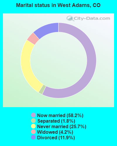
- Never married: 25.7%
- Now married: 58.2%
- Separated: 1.8%
- Widowed: 4.2%
- Divorced: 11.9%
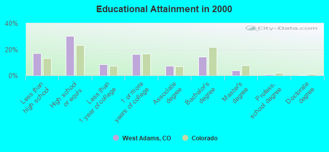
For population 25 years and over in West Adams:
- High school or higher: 82.8%
- Bachelor's degree or higher: 20.0%
- Graduate or professional degree: 5.5%
- Unemployed: 4.0%
- Mean travel time to work (commute): 26.7 minutes
| Here: | 11.1 |
| Colorado average: | 11.8 |
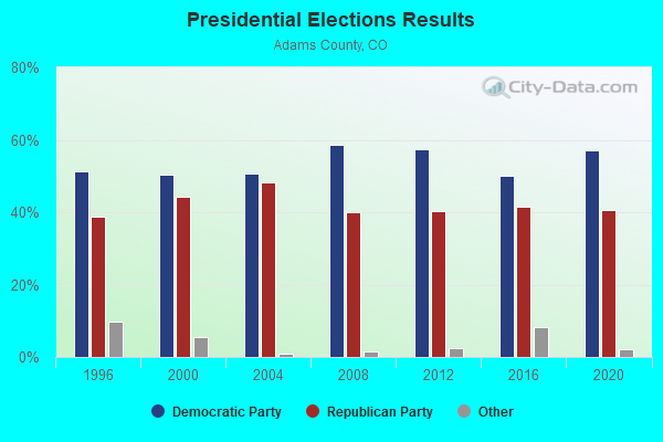
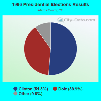
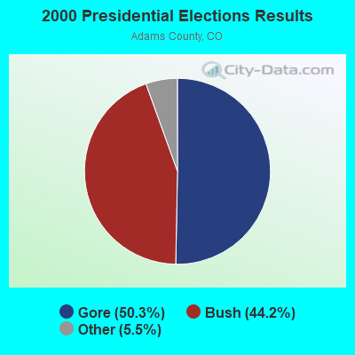
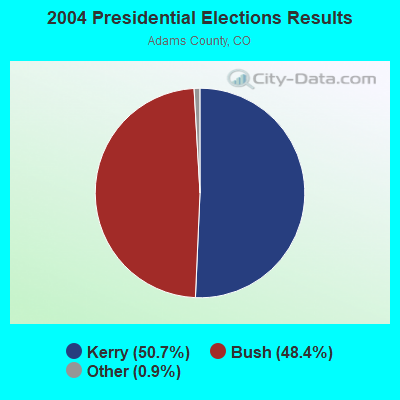
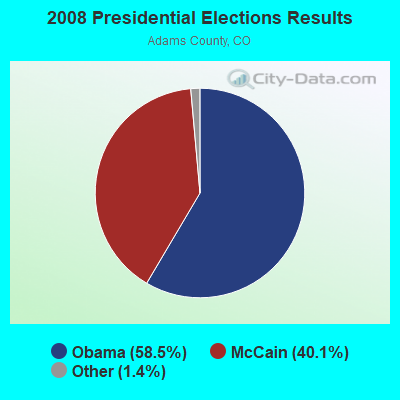
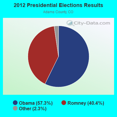
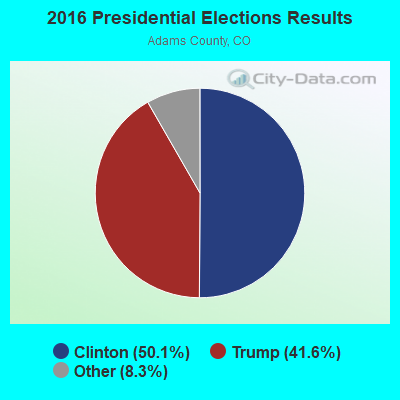
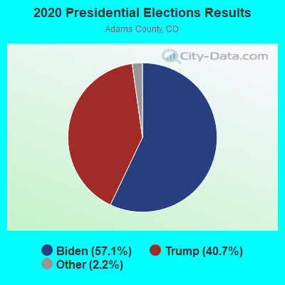
Graphs represent county-level data. Detailed 2008 Election Results
Religion statistics for West Adams, CO (based on Adams County data)
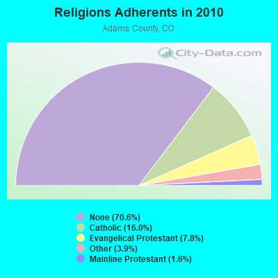
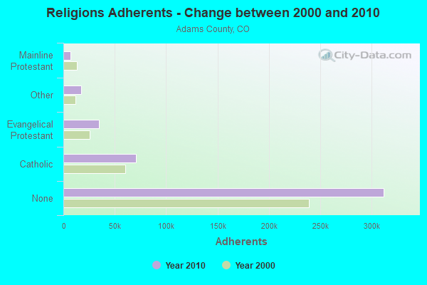
| Religion | Adherents | Congregations |
|---|---|---|
| Catholic | 70,598 | 11 |
| Evangelical Protestant | 34,568 | 159 |
| Other | 17,157 | 38 |
| Mainline Protestant | 7,133 | 33 |
| Black Protestant | 195 | 2 |
| Orthodox | - | 1 |
| None | 311,952 | - |
Food Environment Statistics:
| This county: | 1.16 / 10,000 pop. |
| State: | 1.50 / 10,000 pop. |
| Adams County: | 0.17 / 10,000 pop. |
| Colorado: | 0.15 / 10,000 pop. |
| Here: | 0.21 / 10,000 pop. |
| State: | 0.45 / 10,000 pop. |
| This county: | 2.47 / 10,000 pop. |
| Colorado: | 3.13 / 10,000 pop. |
| Adams County: | 4.66 / 10,000 pop. |
| Colorado: | 8.99 / 10,000 pop. |
| Adams County: | 6.8% |
| Colorado: | 5.3% |
| This county: | 24.3% |
| Colorado: | 18.4% |
| Adams County: | 10.0% |
| Colorado: | 9.6% |
11.65% of this county's 2021 resident taxpayers lived in other counties in 2020 ($55,974 average adjusted gross income)
| Here: | 11.65% |
| Colorado average: | 11.28% |
0.01% of residents moved from foreign countries ($73 average AGI)
Adams County: 0.01% Colorado average: 0.05%
Top counties from which taxpayers relocated into this county between 2020 and 2021:
| from Denver County, CO | |
| from Jefferson County, CO | |
| from Arapahoe County, CO |
11.37% of this county's 2020 resident taxpayers moved to other counties in 2021 ($59,124 average adjusted gross income)
| Here: | 11.37% |
| Colorado average: | 11.05% |
0.01% of residents moved to foreign countries ($78 average AGI)
Adams County: 0.01% Colorado average: 0.03%
Top counties to which taxpayers relocated from this county between 2020 and 2021:
| to Denver County, CO | |
| to Jefferson County, CO | |
| to Arapahoe County, CO |
Strongest AM radio stations in West Adams:
- KLZ (560 AM; 5 kW; DENVER, CO; Owner: KLZ RADIO, INC.)
- KKZN (760 AM; 50 kW; THORNTON, CO; Owner: JACOR BROADCASTING OF COLORADO, INC.)
- KPOF (910 AM; 5 kW; DENVER, CO; Owner: PILLAR OF FIRE)
- KKFN (950 AM; 5 kW; DENVER, CO; Owner: JEFFERSON-PILOT COMMUNICATIONS COMPANY OF COLORADO)
- KJME (1390 AM; 5 kW; DENVER, CO; Owner: JO-MOR COMMUNICATIONS, INC.)
- KRKS (990 AM; 10 kW; DENVER, CO; Owner: SALEM MEDIA OF COLORADO, INC.)
- KHOW (630 AM; 5 kW; DENVER, CO; Owner: CITICASTERS LICENSES, L.P.)
- KLTT (670 AM; 50 kW; COMMERCE CITY, CO; Owner: KLZ RADIO, INC.)
- KBJD (1650 AM; 10 kW; DENVER, CO; Owner: SALEM MEDIA OF COLORADO, INC.)
- KMXA (1090 AM; 50 kW; AURORA, CO; Owner: ENTRAVISION HOLDINGS, LLC)
- KNUS (710 AM; 5 kW; DENVER, CO; Owner: SALEM MEDIA OF COLORADO, INC.)
- KOA (850 AM; 50 kW; DENVER, CO; Owner: JACOR BROADCASTING OF COLORADO, INC.)
- KLMO (1060 AM; 30 kW; LONGMONT, CO; Owner: PILGRIM COMMUNICATIONS, INC.)
Strongest FM radio stations in West Adams:
- KQMT (99.5 FM; DENVER, CO; Owner: ENTERCOM DENVER LICENSE, LLC)
- KALC (105.9 FM; DENVER, CO; Owner: ENTERCOM DENVER LICENSE, LLC)
- KBPI (106.7 FM; DENVER, CO; Owner: JACOR BROADCASTING OF COLORADO, INC.)
- KOSI (101.1 FM; DENVER, CO; Owner: ENTERCOM DENVER LICENSE, LLC)
- KFMD (95.7 FM; DENVER, CO; Owner: CITICASTERS LICENSES, L.P.)
- KRFX (103.5 FM; DENVER, CO; Owner: JACOR BROADCASTING OF COLORADO, INC.)
- KBCO-FM (97.3 FM; BOULDER, CO; Owner: CITICASTERS LICENSES, L.P.)
- KJCD (104.3 FM; LONGMONT, CO; Owner: JEFFERSON-PILOT COMMUNICATIONS COMPANY OF COLORADO)
- KQKS (107.5 FM; LAKEWOOD, CO; Owner: JEFFERSON-PILOT COMMUNICATIONS COMPANY OF COLORADO)
- KDJM (92.5 FM; BROOMFIELD, CO; Owner: INFINITY RADIO OPERATIONS INC.)
- KTCL (93.3 FM; FORT COLLINS, CO; Owner: JACOR BROADCASTING OF COLORADO, INC.)
- KRKS-FM (94.7 FM; LAFAYETTE, CO; Owner: SALEM MEDIA OF COLORADO, INC)
- KUVO (89.3 FM; DENVER, CO; Owner: DENVER EDUCATIONAL BROADCASTING)
- KIMN (100.3 FM; DENVER, CO; Owner: INFINITY RADIO OPERATIONS INC.)
- KVOD (90.1 FM; DENVER, CO; Owner: PUBLIC BROADCASTING OF COLORADO, INC)
- KXKL-FM (105.1 FM; DENVER, CO; Owner: INFINITY RADIO OPERATIONS INC.)
- KYGO-FM (98.5 FM; DENVER, CO; Owner: JEFFERSON-PILOT COMMUNICATIONS COMPANY OF COLORADO)
- K209DE (89.7 FM; GOLDEN, CO; Owner: WAY-FM MEDIA GROUP, INC.)
- KLDV (91.1 FM; MORRISON, CO; Owner: EDUCATIONAL MEDIA FOUNDATION)
- KXPK (96.5 FM; EVERGREEN, CO; Owner: ENTRAVISION HOLDINGS, LLC)
TV broadcast stations around West Adams:
- K66FB (Channel 66; DENVER, CO; Owner: TRINITY BROADCASTING NETWORK)
- KMGH-TV (Channel 7; DENVER, CO; Owner: MCGRAW-HILL BROADCASTING COMPANY, INC.)
- KRMA-TV (Channel 6; DENVER, CO; Owner: ROCKY MOUNTAIN PUBLIC BROADCASTING NETWORK, INC.)
- KUSA-TV (Channel 9; DENVER, CO; Owner: MULTIMEDIA HOLDINGS CORPORATION)
- KDEN (Channel 25; LONGMONT, CO; Owner: LONGMONT CHANNEL 25, INC.)
- KTVD (Channel 20; DENVER, CO; Owner: TWENVER BROADCAST, INC.)
- KCNC-TV (Channel 4; DENVER, CO; Owner: CBS TELEVISION STATIONS INC.)
- K48FW (Channel 48; DENVER, CO; Owner: TRINITY BROADCASTING NETWORK)
- KWGN-TV (Channel 2; DENVER, CO; Owner: KWGN INC.)
- KDEO-LP (Channel 38; AURORA, CO; Owner: PETER B. VAN DE SANDE)
- KMAS-LP (Channel 63; DENVER, CO; Owner: TELEMUNDO OF STEAMBOAT SPRINGS COLO. LIC. CORP.)
- KDVR (Channel 31; DENVER, CO; Owner: FOX TELEVISION STATIONS, INC.)
- KDEV-LP (Channel 62; AURORA, CO; Owner: TIGER EYE BROADCASTING CORPORATION)
- KPXC-TV (Channel 59; DENVER, CO; Owner: PAXSON DENVER LICENSE, INC.)
- K47IH (Channel 47; BOULDER, CO; Owner: CHANNEL 20 TV COMPANY)
- K44CT (Channel 44; BOULDER, CO; Owner: ROCKY MOUNTAIN PUBLIC BROADCASTING NETWORK, INC.)
- KDVT-LP (Channel 36; DENVER, CO; Owner: ENTRAVISION HOLDINGS, LLC)
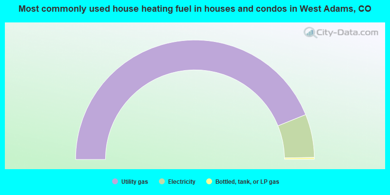
- 87.6%Utility gas
- 11.7%Electricity
- 0.5%Bottled, tank, or LP gas
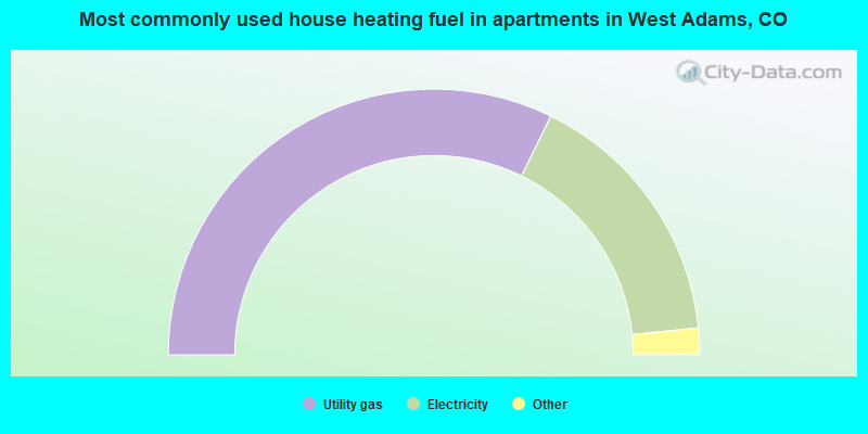
- 64.5%Utility gas
- 32.3%Electricity
- 1.4%Bottled, tank, or LP gas
- 0.9%Other fuel
- 0.7%No fuel used
West Adams compared to Colorado state average:
- Unemployed percentage significantly below state average.
- Black race population percentage below state average.
- Median age below state average.
- Foreign-born population percentage significantly below state average.
- Length of stay since moving in significantly above state average.
- Number of rooms per house significantly below state average.
- House age significantly below state average.
- Percentage of population with a bachelor's degree or higher below state average.
West Adams, CO compared to other similar cities:
West Adams on our top lists:
- #1 on the list of "Top 101 cities with largest percentage of males in occupations: other transportation workers (population 50,000+)"
- #2 on the list of "Top 101 cities with largest percentage of females in occupations: bookkeeping, accounting, and auditing clerks (population 50,000+)"
- #3 on the list of "Top 101 cities with largest percentage of females in occupations: electrical equipment mechanics and other installation, maintenance, and repair occupations including supervisors (population 50,000+)"
- #3 on the list of "Top 101 cities with largest percentage of females in industries: broadcasting and telecommunications (population 50,000+)"
- #3 on the list of "Top 101 cities with largest percentage of females in industries: vending machine operators (population 50,000+)"
- #4 on the list of "Top 101 cities with largest percentage of females in occupations: customer service representatives (population 50,000+)"
- #4 on the list of "Top 101 cities with largest percentage of females in industries: hardware, plumbing and heating equipment, and supplies merchant wholesalers (population 50,000+)"
- #5 on the list of "Top 101 cities with largest percentage of males in industries: furniture and home furnishings, and household appliance stores (population 50,000+)"
- #5 on the list of "Top 101 cities with largest percentage of males in industries: furniture and home furnishing merchant wholesalers (population 50,000+)"
- #6 on the list of "Top 101 cities with largest percentage of females in industries: furniture and home furnishing merchant wholesalers (population 50,000+)"
- #6 on the list of "Top 101 cities with largest percentage of females in industries: computer and electronic products (population 50,000+)"
- #6 on the list of "Top 101 cities with largest percentage of males in industries: broadcasting and telecommunications (population 50,000+)"
- #7 on the list of "Top 101 cities with largest percentage of males in industries: hardware, plumbing and heating equipment, and supplies merchant wholesalers (population 50,000+)"
- #7 on the list of "Top 101 cities with largest percentage of males in industries: metals and minerals, except petroleum, merchant wholesalers (population 50,000+)"
- #7 on the list of "Top 101 cities with largest percentage of females in industries: truck transportation (population 50,000+)"
- #8 on the list of "Top 101 cities with largest percentage of females in occupations: food processing workers (population 50,000+)"
- #8 on the list of "Top 101 cities with largest percentage of males in occupations: pipelayers, plumbers, pipefitters, and steamfitters (population 50,000+)"
- #9 on the list of "Top 101 cities with largest percentage of females in industries: professional and commercial equipment and supplies merchant wholesalers (population 50,000+)"
- #9 on the list of "Top 101 cities with largest percentage of females in industries: u. s. postal service (population 50,000+)"
- #10 on the list of "Top 101 cities with largest percentage of males in industries: beverage and tobacco products (population 50,000+)"
- #3 on the list of "Top 101 counties with the highest Nitrogen Dioxide air pollution readings in 2012 (ppm)"
- #24 on the list of "Top 101 counties with the highest carbon monoxide air pollution readings in 2012 (ppm)"
- #32 on the list of "Top 101 counties with the lowest percentage of residents that visited a dentist within the past year"
- #59 on the list of "Top 101 counties with the lowest percentage of residents relocating from foreign countries between 2010 and 2011 (pop. 50,000+)"
- #59 on the list of "Top 101 counties with the largest decrease in the number of infant deaths per 1000 residents 2000-2006 to 2007-2013 (pop. 50,000+)"