West Choctaw, Oklahoma
Submit your own pictures of this place and show them to the world
- OSM Map
- General Map
- Google Map
- MSN Map

| Males: 1,486 | |
| Females: 1,600 |
| Median resident age: | 38.7 years |
| Oklahoma median age: | 35.5 years |
Zip code: 74727
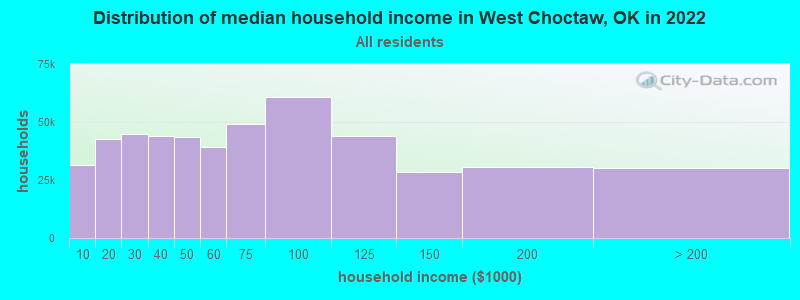
| West Choctaw: | $38,374 |
| OK: | $59,673 |
Estimated per capita income in 2022: $21,960 (it was $10,907 in 2000)
West Choctaw CCD income, earnings, and wages data
Estimated median house or condo value in 2022: $131,963 (it was $45,500 in 2000)
| West Choctaw: | $131,963 |
| OK: | $191,700 |
Mean prices in 2022: all housing units: $207,698; detached houses: $225,205; townhouses or other attached units: $121,845; mobile homes: $111,826; occupied boats, rvs, vans, etc.: $29,865
Detailed information about poverty and poor residents in West Choctaw, OK


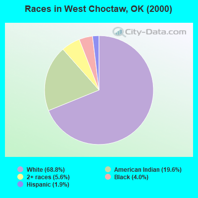
- 2,17168.8%White alone
- 61819.6%American Indian alone
- 1765.6%Two or more races
- 1274.0%Black alone
- 591.9%Hispanic
- 20.06%Native Hawaiian and Other
Pacific Islander alone - 10.03%Asian alone
Races in West Choctaw detailed stats: ancestries, foreign born residents, place of birth
 Recent articles from our blog. Our writers, many of them Ph.D. graduates or candidates, create easy-to-read articles on a wide variety of topics.
Current Local Time: CST time zone
Land area: 308.0 square miles.
Population density: 10 people per square mile (very low).

| West Choctaw CCD: | 0.4% ($199) |
| Oklahoma: | 0.8% ($523) |
Nearest city with pop. 50,000+: East Grayson, TX (51.4 miles  , pop. 81,381).
Nearest city with pop. 200,000+: Plano, TX (87.1 miles , pop. 222,030).
Nearest city with pop. 1,000,000+: Dallas, TX (102.5 miles , pop. 1,188,580).
Nearest cities:
), ), ), ), )Latitude: 34.03 N, Longitude: 95.79 W
Area code commonly used in this area: 580

| Here: | 4.2% |
| Oklahoma: | 3.2% |
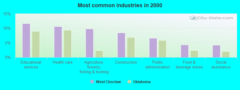
- Educational services (11.6%)
- Health care (10.7%)
- Agriculture, forestry, fishing & hunting (9.8%)
- Construction (8.5%)
- Public administration (6.6%)
- Food & beverage stores (4.3%)
- Social assistance (4.2%)
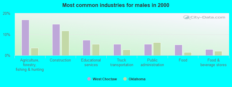
- Agriculture, forestry, fishing & hunting (16.9%)
- Construction (14.9%)
- Educational services (7.3%)
- Truck transportation (5.4%)
- Public administration (5.4%)
- Food (5.1%)
- Food & beverage stores (2.9%)
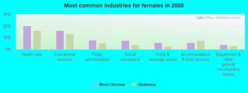
- Health care (20.2%)
- Educational services (16.2%)
- Public administration (7.9%)
- Social assistance (7.6%)
- Food & beverage stores (5.8%)
- Accommodation & food services (5.8%)
- Department & other general merchandise stores (4.0%)
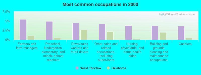
- Farmers and farm managers (5.4%)
- Preschool, kindergarten, elementary, and middle school teachers (4.9%)
- Driver/sales workers and truck drivers (4.5%)
- Other sales and related occupations, including supervisors (4.2%)
- Nursing, psychiatric, and home health aides (3.8%)
- Building and grounds cleaning and maintenance occupations (3.7%)
- Cashiers (3.6%)
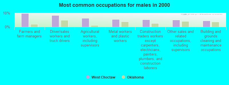
- Farmers and farm managers (9.8%)
- Driver/sales workers and truck drivers (8.5%)
- Agricultural workers, including supervisors (6.3%)
- Metal workers and plastic workers (5.4%)
- Construction traders workers except carpenters, electricians, painters, plumbers, and construction laborers (5.2%)
- Other sales and related occupations, including supervisors (5.1%)
- Building and grounds cleaning and maintenance occupations (4.6%)
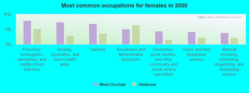
- Preschool, kindergarten, elementary, and middle school teachers (7.9%)
- Nursing, psychiatric, and home health aides (7.4%)
- Cashiers (6.9%)
- Secretaries and administrative assistants (5.1%)
- Counselors, social workers, and other community and social service specialists (4.4%)
- Cooks and food preparation workers (4.2%)
- Material recording, scheduling, dispatching, and distributing workers (3.9%)
Average climate in West Choctaw, Oklahoma
Based on data reported by over 4,000 weather stations


Tornado activity:
West Choctaw-area historical tornado activity is slightly below Oklahoma state average. It is 111% greater than the overall U.S. average.
On 4/2/1982, a category F5 (max. wind speeds 261-318 mph) tornado 14.6 miles away from the West Choctaw place center injured 29 people and caused between $500,000 and $5,000,000 in damages.
On 5/4/1960, a category F4 (max. wind speeds 207-260 mph) tornado 5.3 miles away from the place center injured 3 people and caused between $50,000 and $500,000 in damages.
Earthquake activity:
West Choctaw-area historical earthquake activity is significantly above Oklahoma state average. It is 591% greater than the overall U.S. average.On 11/6/2011 at 03:53:10, a magnitude 5.7 (5.7 MW, Depth: 3.2 mi, Class: Moderate, Intensity: VI - VII) earthquake occurred 117.9 miles away from the city center
On 9/3/2016 at 12:02:44, a magnitude 5.8 (5.8 MW, Depth: 3.5 mi) earthquake occurred 177.9 miles away from West Choctaw center
On 11/7/2016 at 01:44:24, a magnitude 5.0 (5.0 MW, Depth: 2.8 mi) earthquake occurred 147.4 miles away from West Choctaw center
On 11/8/2011 at 02:46:57, a magnitude 4.8 (4.8 MW, Depth: 3.1 mi, Class: Light, Intensity: IV - V) earthquake occurred 118.4 miles away from West Choctaw center
On 11/5/2011 at 07:12:45, a magnitude 4.8 (4.8 MW, Depth: 1.9 mi) earthquake occurred 119.0 miles away from West Choctaw center
On 9/6/1997 at 23:38:00, a magnitude 4.5 (4.5 LG, 4.2 LG, Depth: 3.1 mi) earthquake occurred 57.2 miles away from West Choctaw center
Magnitude types: regional Lg-wave magnitude (LG), moment magnitude (MW)
Natural disasters:
The number of natural disasters in Choctaw County (18) is near the US average (15).Major Disasters (Presidential) Declared: 11
Emergencies Declared: 6
Causes of natural disasters: Floods: 8, Storms: 8, Winter Storms: 6, Tornadoes: 4, Fire: 1, Heavy Rain: 1, Hurricane: 1, Snow: 1, Wind: 1, Other: 1 (Note: some incidents may be assigned to more than one category).
Colleges/universities with over 2000 students nearest to West Choctaw:
- Paris Junior College (about 31 miles; Paris, TX; Full-time enrollment: 3,875)
- Southeastern Oklahoma State University (about 34 miles; Durant, OK; FT enrollment: 3,365)
- Grayson College (about 54 miles; Denison, TX; FT enrollment: 2,496)
- Texas A & M University-Commerce (about 55 miles; Commerce, TX; FT enrollment: 8,890)
- East Central University (about 72 miles; Ada, OK; FT enrollment: 4,030)
- Collin County Community College District (about 78 miles; McKinney, TX; FT enrollment: 18,044)
- Northeast Texas Community College (about 83 miles; Mount Pleasant, TX; FT enrollment: 2,320)
Points of interest:
Notable locations in West Choctaw: Bluff Fire Department (A), Nelson Volunteer Fire Department (B), Boswell Volunteer Fire Department Station 1 Headquarters (C), Soper Volunteer Fire Department (D), Boswell Volunteer Fire Department Station 2 (E). Display/hide their locations on the map
Churches in West Choctaw include: Good Springs Church (A), Iron Stob Church (B), Oak Ridge Church (C), Mount Sinai Church (D), Homers Chapel (E), Pierce Church (F), Pigeon Roost Church (G), Timber Hill Church (H), Saint James Church Number 2 (I). Display/hide their locations on the map
Cemeteries: Wade Cemetery (1), Bluff Cemetery (2), Pigeon Roost Cemetery (3), Homer's Chapel Cemetery (4), Good Springs Cemetery (5), Dill Cemetery (6), Crowder Springs Cemetery (7). Display/hide their locations on the map
Lakes and reservoirs: Louie Lake (A), Mosley Lake (B), Hopena Lake (C), Hogpen Lake (D), Edmond Slough (E), Salt Lake (F), Dobbins Lake (G), Colbert Lake (H). Display/hide their locations on the map
Streams, rivers, and creeks: Bokchito Creek (A), Big Branch (B), Bee Creek (C), Beaverdam Creek (D), Tanyard Creek (E), Cold Springs Creek (F), Sugar Creek (G), Spring Branch (H), Clear Boggy Creek (I). Display/hide their locations on the map
Park in West Choctaw: Boswell State Park (1). Display/hide its location on the map
| This place: | 2.4 people |
| Oklahoma: | 2.5 people |
| This place: | 69.2% |
| Whole state: | 66.8% |
| This place: | 4.6% |
| Whole state: | 5.9% |
Likely homosexual households (counted as self-reported same-sex unmarried-partner households)
- Lesbian couples: 0.1% of all households
- Gay men: 0.2% of all households
| This place: | 25.6% |
| Whole state: | 14.7% |
| This place: | 10.0% |
| Whole state: | 6.1% |
For population 15 years and over in West Choctaw:
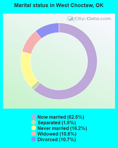
- Never married: 16.2%
- Now married: 62.5%
- Separated: 1.6%
- Widowed: 10.6%
- Divorced: 10.7%
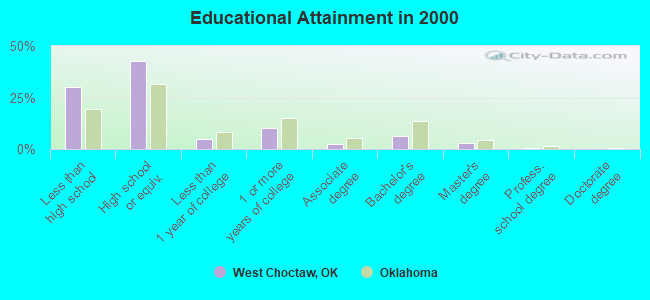
For population 25 years and over in West Choctaw:
- High school or higher: 69.8%
- Bachelor's degree or higher: 9.8%
- Graduate or professional degree: 3.4%
- Unemployed: 6.4%
- Mean travel time to work (commute): 31.1 minutes
| Here: | 12.1 |
| Oklahoma average: | 11.7 |

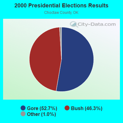
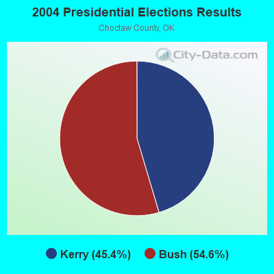

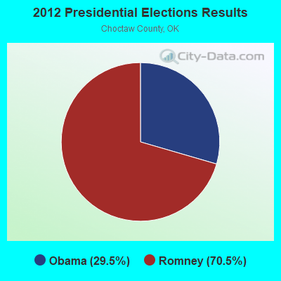
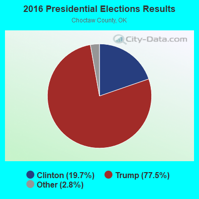
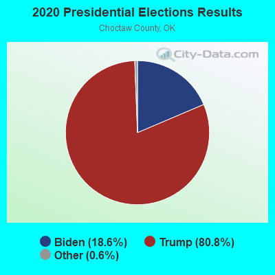
Graphs represent county-level data. Detailed 2008 Election Results
Religion statistics for West Choctaw, OK (based on Choctaw County data)
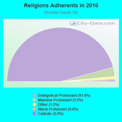
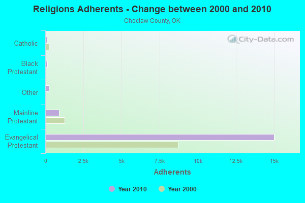
| Religion | Adherents | Congregations |
|---|---|---|
| Evangelical Protestant | 15,020 | 39 |
| Mainline Protestant | 902 | 14 |
| Other | 250 | 2 |
| Black Protestant | 124 | 1 |
| Catholic | 100 | 2 |
| None | - | - |
Food Environment Statistics:
| Here: | 0.67 / 10,000 pop. |
| Oklahoma: | 1.97 / 10,000 pop. |
| This county: | 0.67 / 10,000 pop. |
| Oklahoma: | 0.20 / 10,000 pop. |
| Choctaw County: | 0.67 / 10,000 pop. |
| Oklahoma: | 0.76 / 10,000 pop. |
| Choctaw County: | 8.00 / 10,000 pop. |
| Oklahoma: | 4.35 / 10,000 pop. |
| Here: | 8.00 / 10,000 pop. |
| State: | 6.89 / 10,000 pop. |
| Choctaw County: | 11.7% |
| Oklahoma: | 10.3% |
| Here: | 29.9% |
| State: | 29.2% |
Strongest AM radio stations in West Choctaw:
- KFXR (1190 AM; 50 kW; DALLAS, TX; Owner: CLEAR CHANNEL BROADCASTING LICENSES, INC.)
- KRLD (1080 AM; 50 kW; DALLAS, TX; Owner: TEXAS INFINITY BROADCASTING L.P.)
- KYNG (950 AM; 10 kW; DENISON-SHERMAN, TX; Owner: KRBE LICO, INC.)
- WBAP (820 AM; 50 kW; FORT WORTH, TX; Owner: WBAP-KSCS OPERATING, LTD.)
- KEOR (1110 AM; daytime; 5 kW; ATOKA, OK; Owner: DALLAS AM RADIO PARTNERS, L.P.)
- KEEL (710 AM; 50 kW; SHREVEPORT, LA; Owner: CITICASTERS LICENSES, L.P.)
- KRMG (740 AM; 50 kW; TULSA, OK; Owner: CXR HOLDINGS, INC.)
- KZMP (1540 AM; 50 kW; UNIVERSITY PARK, TX; Owner: ENTRAVISION HOLDINGS, LLC)
- KSKY (660 AM; 20 kW; BALCH SPRINGS, TX; Owner: BISON MEDIA, INC.)
- KESS (1270 AM; 50 kW; FORT WORTH, TX; Owner: KESS-AM LICENSE CORP.)
- KTBK (1700 AM; 10 kW; SHERMAN, TX; Owner: KRBE LICO, INC.)
- KIHN (1340 AM; 1 kW; HUGO, OK; Owner: LITTLE DIXIE BROADCASTING CO.)
- KAHZ (1360 AM; 50 kW; HURST, TX)
Strongest FM radio stations in West Choctaw:
- KITX (95.5 FM; HUGO, OK; Owner: K95.5, INC.)
- KOYN (93.9 FM; PARIS, TX; Owner: EAST TEXAS BROADCASTING, INC.)
- KPLT-FM (107.7 FM; PARIS, TX; Owner: EAST TEXAS BROADCASTING, INC.)
- KBUS (101.9 FM; PARIS, TX; Owner: EAST TEXAS BROADCASTING, INC.)
- KHCP (89.3 FM; PARIS, TX; Owner: HOUSTON CHRISTIAN BROADCASTERS, INC.)
TV broadcast stations around West Choctaw:
- K15AA (Channel 15; HUGO, OK; Owner: OKLAHOMA EDUCATIONAL TELEVISION AUTHORITY)
- KTEN (Channel 10; ADA, OK; Owner: CHANNEL 49 ACQUISITION CORPORATION)
- K42DA (Channel 42; PARIS, TX; Owner: TRINITY BROADCASTING NETWORK)
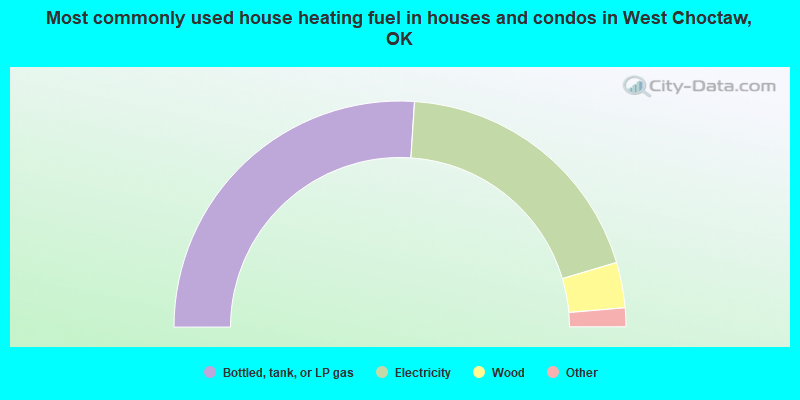
- 52.0%Bottled, tank, or LP gas
- 38.7%Electricity
- 6.5%Wood
- 2.1%Utility gas
- 0.6%Other fuel

- 64.5%Bottled, tank, or LP gas
- 27.3%Electricity
- 3.8%Wood
- 2.0%Utility gas
- 2.0%Other fuel
- 0.3%Solar energy
West Choctaw compared to Oklahoma state average:
- Median household income below state average.
- Unemployed percentage below state average.
- Hispanic race population percentage significantly below state average.
- Foreign-born population percentage significantly below state average.
- Length of stay since moving in significantly above state average.
- Number of rooms per house significantly below state average.
- House age significantly below state average.
- Percentage of population with a bachelor's degree or higher below state average.