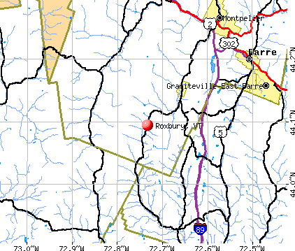
Roxbury, Vermont
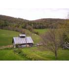
Roxbury: Don Jerry's Sugarhouse
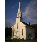
Roxbury: church
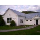
Roxbury: village school
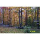
Roxbury: Beauty from lawn on Raynor Road
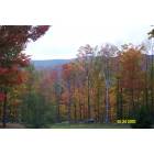
Roxbury: Looking west from Raynor Road
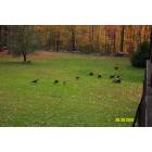
Roxbury: Lawn on Raynor Road
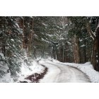
Roxbury: looking down oxbow road/december 2009
- add
your
Submit your own pictures of this town and show them to the world
- OSM Map
- General Map
- Google Map
- MSN Map
Population change since 2000: +20.0%
 |
| Males: 365 | |
| Females: 326 |
| Median resident age: | 44.9 years |
| Vermont median age: | 45.8 years |
Zip codes: 05669.
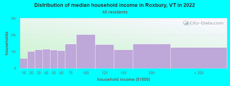
| Roxbury: | $81,904 |
| VT: | $73,991 |
Estimated per capita income in 2022: $34,851 (it was $16,880 in 2000)
Roxbury town income, earnings, and wages data
Estimated median house or condo value in 2022: $258,644 (it was $87,500 in 2000)
| Roxbury: | $258,644 |
| VT: | $304,700 |
Mean prices in 2022: all housing units: $350,068; detached houses: $366,162; townhouses or other attached units: $355,423; in 2-unit structures: $373,534; in 3-to-4-unit structures: $653,333; in 5-or-more-unit structures: $271,088; mobile homes: $98,551
Detailed information about poverty and poor residents in Roxbury, VT
Compare current foreclosures near Roxbury, VT:
| Photo | Address | Area | Beds / Baths | Price | Details |
|---|---|---|---|---|---|

|
#1
Railroad St
Barre, VT 05641
|
- sq. feet
|
1 baths 3 beds |
$83,400
|
show details |

|
#2
Rabbit Hollow Rd
Northfield, VT 05663
|
- sq. feet
|
- baths - beds |
show details | |

|
#3
Vt Route 64
Williamstown, VT 05679
|
- sq. feet
|
- baths - beds |
show details | |

|
#4
Ayers St Apt 4
Barre, VT 05641
|
- sq. feet
|
- baths - beds |
show details | |

|
#5
Cedar Hill Ln Apt 30
Montpelier, VT 05602
|
- sq. feet
|
- baths - beds |
show details | |

|
#6
Elm St
Montpelier, VT 05602
|
- sq. feet
|
- baths - beds |
show details | |

|
#7
Monarch Hill Rd
Tunbridge, VT 05077
|
- sq. feet
|
- baths - beds |
show details | |

|
#8
Elm St Apt 3
Montpelier, VT 05602
|
- sq. feet
|
- baths - beds |
show details | |

|
#9
Dartt Hill Rd, # Po122
Bethel, VT 05032
|
- sq. feet
|
- baths - beds |
show details | |

|
#10
Terrace Dr
Northfield, VT 05663
|
- sq. feet
|
- baths - beds |
show details |
| Photo | Address | Area | Beds / Baths | Price | Details |
|---|---|---|---|---|---|

|
#11
Woodchuck Hollow Rd
Washington, VT 05675
|
- sq. feet
|
- baths - beds |
show details | |

|
Check over 1 million property listings on Foreclosure.com!
|
browse all offers | |||

- 66996.8%White alone
- 121.7%Two or more races
- 60.9%Hispanic
- 20.3%Black alone
- 10.1%American Indian alone
- 10.1%Asian alone
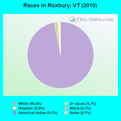
Races in Roxbury detailed stats: ancestries, foreign born residents, place of birth
According to our research of Vermont and other state lists, there was 1 registered sex offender living in Roxbury, Vermont as of April 26, 2024.
The ratio of all residents to sex offenders in Roxbury is 691 to 1.
The ratio of registered sex offenders to all residents in this city is lower than the state average.
 Recent articles from our blog. Our writers, many of them Ph.D. graduates or candidates, create easy-to-read articles on a wide variety of topics.

 | Town Meeting Day 2022 (5 replies) |
| Vermont vs New Hampshire vs Maine - which to move to? (36 replies) |
| What's the deal with Roxbury? (12 replies) |
| News: "Vermont Roots Migration Survey: The Stayers, The Leavers And The Returnees" (70 replies) |
| So what IS the steepest road in Vermont? (13 replies) |
| Favorite towns in top half of VT? (23 replies) |
Latest news from Roxbury, VT collected exclusively by city-data.com from local newspapers, TV, and radio stations
Ancestries: French (31.9%), English (25.3%), Irish (17.2%), German (10.4%), United States (10.1%), Italian (5.7%).
Current Local Time: EST time zone
Elevation: 1010 feet
Land area: 41.8 square miles.
Population density: 17 people per square mile (very low).
12 residents are foreign born (1.4% Asia, 0.7% North America).
| This town: | 2.1% |
| Vermont: | 3.8% |
| Roxbury town: | 1.7% ($1,448) |
| Vermont: | 2.0% ($2,196) |
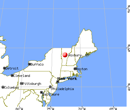
Nearest city with pop. 50,000+: Manchester, NH  (98.7 miles , pop. 107,006).
Nearest city with pop. 200,000+: Boston, MA (146.6 miles , pop. 589,141).
Nearest city with pop. 1,000,000+: Bronx, NY (230.6 miles , pop. 1,332,650).
Nearest cities:
), ), ), ), ), ), )Latitude: 44.07 N, Longitude: 72.73 W
Area code commonly used in this area: 802

| Here: | 2.8% |
| Vermont: | 2.0% |
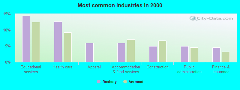
- Educational services (14.4%)
- Health care (12.7%)
- Apparel (6.0%)
- Accommodation & food services (6.0%)
- Construction (4.9%)
- Public administration (4.9%)
- Finance & insurance (4.6%)
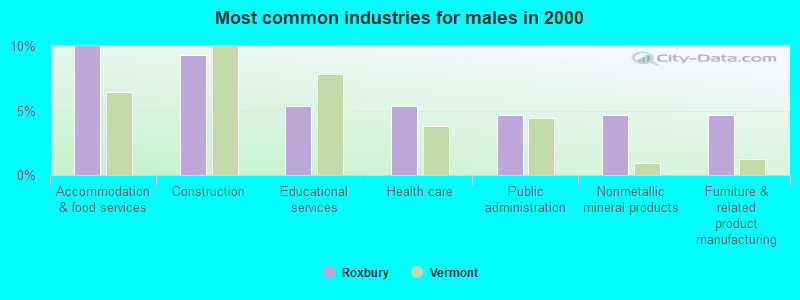
- Accommodation & food services (10.0%)
- Construction (9.3%)
- Educational services (5.3%)
- Health care (5.3%)
- Public administration (4.7%)
- Nonmetallic mineral products (4.7%)
- Furniture & related product manufacturing (4.7%)
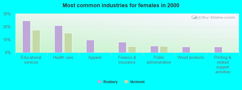
- Educational services (24.6%)
- Health care (20.9%)
- Apparel (9.7%)
- Finance & insurance (8.2%)
- Public administration (5.2%)
- Wood products (4.5%)
- Printing & related support activities (4.5%)
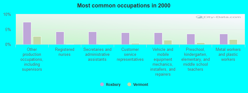
- Other production occupations, including supervisors (7.4%)
- Registered nurses (4.2%)
- Secretaries and administrative assistants (4.2%)
- Customer service representatives (3.9%)
- Vehicle and mobile equipment mechanics, installers, and repairers (3.9%)
- Preschool, kindergarten, elementary, and middle school teachers (3.5%)
- Metal workers and plastic workers (3.5%)
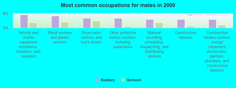
- Vehicle and mobile equipment mechanics, installers, and repairers (7.3%)
- Metal workers and plastic workers (6.7%)
- Driver/sales workers and truck drivers (5.3%)
- Other protective service workers, including supervisors (5.3%)
- Material recording, scheduling, dispatching, and distributing workers (4.7%)
- Construction laborers (4.7%)
- Construction traders workers except carpenters, electricians, painters, plumbers, and construction laborers (4.7%)
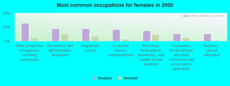
- Other production occupations, including supervisors (12.7%)
- Secretaries and administrative assistants (9.0%)
- Registered nurses (9.0%)
- Customer service representatives (8.2%)
- Preschool, kindergarten, elementary, and middle school teachers (7.5%)
- Counselors, social workers, and other community and social service specialists (5.2%)
- Teachers, special education (5.2%)
Average climate in Roxbury, Vermont
Based on data reported by over 4,000 weather stations


Earthquake activity:
Roxbury-area historical earthquake activity is significantly above Vermont state average. It is 71% smaller than the overall U.S. average.On 4/20/2002 at 10:50:47, a magnitude 5.3 (5.3 ML, Depth: 3.0 mi, Class: Moderate, Intensity: VI - VII) earthquake occurred 56.8 miles away from Roxbury center
On 4/20/2002 at 10:50:47, a magnitude 5.2 (5.2 MB, 4.2 MS, 5.2 MW, 5.0 MW) earthquake occurred 56.8 miles away from the city center
On 10/7/1983 at 10:18:46, a magnitude 5.3 (5.1 MB, 5.3 LG, 5.1 ML) earthquake occurred 80.7 miles away from the city center
On 1/19/1982 at 00:14:42, a magnitude 4.7 (4.5 MB, 4.7 MD, 4.5 LG, Class: Light, Intensity: IV - V) earthquake occurred 68.9 miles away from the city center
On 10/16/2012 at 23:12:25, a magnitude 4.7 (4.7 ML, Depth: 10.0 mi) earthquake occurred 108.5 miles away from Roxbury center
On 6/16/1995 at 12:13:11, a magnitude 3.8 (3.8 LG, Depth: 3.1 mi, Class: Light, Intensity: II - III) earthquake occurred 43.0 miles away from the city center
Magnitude types: regional Lg-wave magnitude (LG), body-wave magnitude (MB), duration magnitude (MD), local magnitude (ML), surface-wave magnitude (MS), moment magnitude (MW)
Natural disasters:
The number of natural disasters in Washington County (26) is a lot greater than the US average (15).Major Disasters (Presidential) Declared: 20
Emergencies Declared: 1
Causes of natural disasters: Floods: 21, Storms: 18, Heavy Rains: 2, Tropical Storms: 2, Winds: 2, Hurricane: 1, Landslide: 1, Winter Storm: 1, Other: 1 (Note: some incidents may be assigned to more than one category).
Hospitals and medical centers near Roxbury:
- MAYO HEALTHCARE INC. (Nursing Home, about 7 miles away; NORTHFIELD, VT)
- GIFFORD ELDERLY CARE INC (Nursing Home, about 11 miles away; RANDOLPH, VT)
- GIFFORD MEDICAL CENTER Critical Access Hospitals (about 12 miles away; RANDOLPH, VT)
- MENIG EXTENDED CARE (Nursing Home, about 12 miles away; RANDOLPH, VT)
- CENTRAL VERMONT HOME HEALTH AND HOSPICE (Home Health Center, about 13 miles away; BARRE, VT)
- BERLIN HEALTH AND REHAB CTR (Nursing Home, about 14 miles away; BARRE, VT)
- ROWAN COURT HEALTH AND REHAB (Nursing Home, about 14 miles away; BARRE, VT)
Amtrak stations near Roxbury:
- 11 miles: RANDOLPH (DEPOT SQ.) . Services: enclosed waiting area, public restrooms, public payphones, snack bar, ATM, free short-term parking, free long-term parking, public transit connection.
- 15 miles: MONTPELIER-BARRE (MONTPELIER, MONTPELIER JCT. RD.) . Services: enclosed waiting area, public restrooms, public payphones, free short-term parking, free long-term parking, call for car rental service, call for taxi service.
- 19 miles: WATERBURY-STOWE (WATERBURY, PARK ROW) . Services: enclosed waiting area, public restrooms, public payphones, free short-term parking, free long-term parking, call for car rental service, call for taxi service, intercity bus service.
Colleges/universities with over 2000 students nearest to Roxbury:
- Norwich University (about 6 miles; Northfield, VT; Full-time enrollment: 4,221)
- Middlebury College (about 23 miles; Middlebury, VT; FT enrollment: 3,077)
- Dartmouth College (about 34 miles; Hanover, NH; FT enrollment: 6,030)
- Saint Michael's College (about 37 miles; Colchester, VT; FT enrollment: 2,336)
- Champlain College (about 37 miles; Burlington, VT; FT enrollment: 2,623)
- University of Vermont (about 37 miles; Burlington, VT; FT enrollment: 11,566)
- Community College of Vermont (about 37 miles; Winooski, VT; FT enrollment: 3,394)
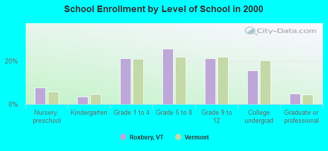
Public elementary/middle school in Roxbury:
- ROXBURY VILLAGE SCHOOL (Students: 67, Location: 1559 ROXBURY ROAD, Grades: PK-6)
Points of interest:
Notable locations in Roxbury: Teela Wooket Camp (A), Roxbury Flat (B), Roxbury Volunteer Fire Department (C). Display/hide their locations on the map
Cemeteries: Roxbury Cemetery (1), Orcutt Cemetery (2), First Settler Cemetery (3), East Roxbury Cemetery (4), Batchellor-Spaulding Cemetery (5). Display/hide their locations on the map
Lake: Beaver Pond (A). Display/hide its location on the map
Streams, rivers, and creeks: Woodard Brook (A), Flint Brook (B), Ellis Brook (C). Display/hide their locations on the map
| This town: | 2.3 people |
| Vermont: | 2.3 people |
| This town: | 68.3% |
| Whole state: | 62.5% |
| This town: | 10.0% |
| Whole state: | 9.2% |
Likely homosexual households (counted as self-reported same-sex unmarried-partner households)
- Lesbian couples: 0.7% of all households
- Gay men: 0.3% of all households
| This town: | 9.1% |
| Whole state: | 9.4% |
| This town: | 4.7% |
| Whole state: | 3.6% |
For population 15 years and over in Roxbury:
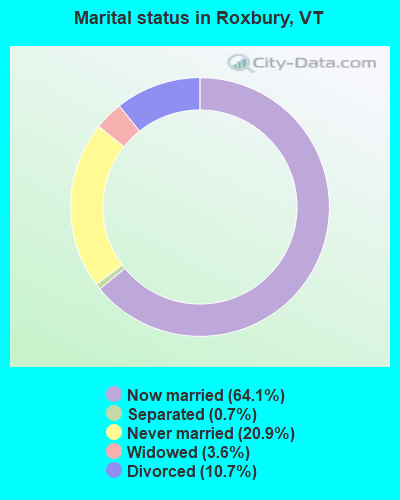
- Never married: 20.9%
- Now married: 64.1%
- Separated: 0.7%
- Widowed: 3.6%
- Divorced: 10.7%
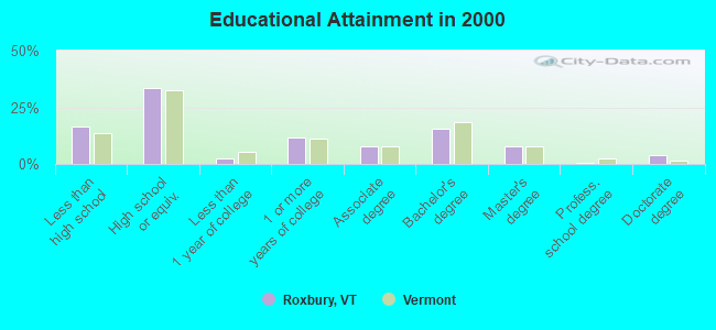
For population 25 years and over in Roxbury:
- High school or higher: 83.4%
- Bachelor's degree or higher: 27.8%
- Graduate or professional degree: 12.3%
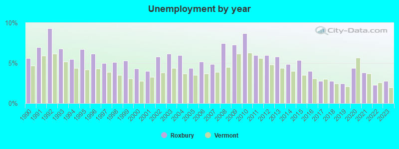
- Unemployed: 7.2%
- Mean travel time to work (commute): 28.5 minutes
| Here: | 12.4 |
| Vermont average: | 11.7 |
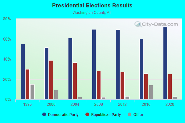
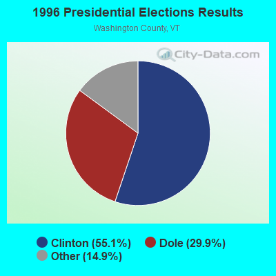
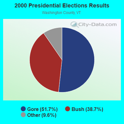
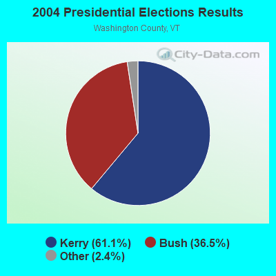
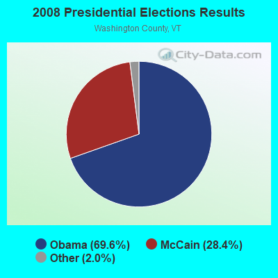
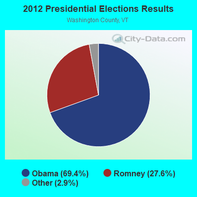
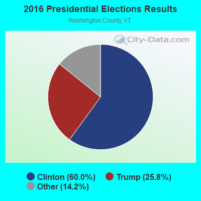
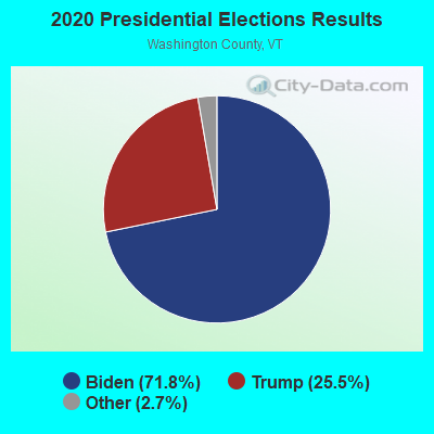
Graphs represent county-level data. Detailed 2008 Election Results
Religion statistics for Roxbury, VT (based on Washington County data)
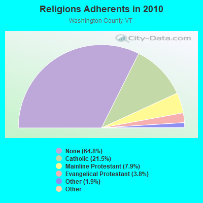
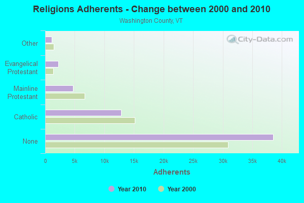
| Religion | Adherents | Congregations |
|---|---|---|
| Catholic | 12,800 | 9 |
| Mainline Protestant | 4,711 | 38 |
| Evangelical Protestant | 2,262 | 28 |
| Other | 1,125 | 12 |
| Orthodox | 50 | 1 |
| Black Protestant | 36 | 1 |
| None | 38,550 | - |
Food Environment Statistics:
| This county: | 4.25 / 10,000 pop. |
| State: | 3.84 / 10,000 pop. |
| Washington County: | 3.06 / 10,000 pop. |
| State: | 1.95 / 10,000 pop. |
| Washington County: | 5.95 / 10,000 pop. |
| Vermont: | 6.40 / 10,000 pop. |
| Washington County: | 11.04 / 10,000 pop. |
| Vermont: | 11.52 / 10,000 pop. |
| This county: | 7.8% |
| Vermont: | 6.8% |
| Washington County: | 21.5% |
| Vermont: | 22.3% |
| Here: | 14.7% |
| Vermont: | 13.3% |
Strongest AM radio stations in Roxbury:
- WDEV (550 AM; 5 kW; WATERBURY, VT; Owner: RADIO VERMONT, INC.)
- WCHP (760 AM; 35 kW; CHAMPLAIN, NY; Owner: CHAMPLAIN RADIO, INC.)
- WWWT (1320 AM; 1 kW; RANDOLPH, VT; Owner: CAPSTAR TX LIMITED PARTNERSHIP)
- WGY (810 AM; 50 kW; SCHENECTADY, NY; Owner: CLEAR CHANNEL BROADCASTING LICENSES, INC.)
- WVMT (620 AM; 5 kW; BURLINGTON, VT; Owner: SISON BROADCASTING, INC.)
- WNNZ (640 AM; 50 kW; WESTFIELD, MA; Owner: CLEAR CHANNEL BROADCASTING LICENSES, INC.)
- WTWN (1100 AM; daytime; 5 kW; WELLS RIVER, VT; Owner: PUFFER BROADCASTING, INC.)
- WICY (1490 AM; 50 kW; MALONE, NY; Owner: CARTIER COMMUNICATIONS INC.)
- WRKO (680 AM; 50 kW; BOSTON, MA; Owner: ENTERCOM BOSTON LICENSE, LLC)
- WSNO (1450 AM; 1 kW; BARRE, VT; Owner: VOX VERMONT, L.L.C)
- WSKI (1240 AM; 1 kW; MONTPELIER, VT; Owner: GALLOWAY COMMUNICATIONS, INC.)
- WCRN (830 AM; 50 kW; WORCESTER, MA; Owner: CARTER BROADCASTING CORPORATION)
- WNTK (1020 AM; 10 kW; NEWPORT, NH; Owner: KOOR COMMUNICATIONS, INC.)
Strongest FM radio stations in Roxbury:
- WDEV-FM (96.1 FM; WARREN, VT; Owner: RADIO VERMONT, INC.)
- WCVT (101.7 FM; STOWE, VT; Owner: RADIO VERMONT CLASSICS, L.L.C.)
- WNCS (104.7 FM; MONTPELIER, VT; Owner: MONTPELIER BROADCASTING, INC.)
- WEBK (105.3 FM; KILLINGTON, VT; Owner: 6 JOHNSON ROAD LICENSES, INC.)
- WVPS (107.9 FM; BURLINGTON, VT; Owner: VERMONT PUBLIC RADIO)
- WEZF (92.9 FM; BURLINGTON, VT; Owner: CAPSTAR TX LIMITED PARTNERSHIP)
- WLKC (103.3 FM; WATERBURY, VT; Owner: RADIO BROADCASTING SERVICES, INC.)
- WJJR (98.1 FM; RUTLAND, VT; Owner: 6 JOHNSON ROAD LICENSES, INC.)
- WZRT (97.1 FM; RUTLAND, VT; Owner: CAPSTAR TX LIMITED PARTNERSHIP)
- WGLV (91.7 FM; WOODSTOCK, VT; Owner: CHRISTIAN MINISTRIES INC)
- WHDQ-FM1 (106.1 FM; RUTLAND, VT; Owner: GREAT NORTHERN RADIO, L.L.C.)
- WCVR-FM (102.1 FM; RANDOLPH, VT; Owner: CAPSTAR TX LIMITED PARTNERSHIP)
- WJEN (94.5 FM; RUTLAND, VT; Owner: 6 JOHNSON ROAD LICENSES, INC.)
- WCMD (89.9 FM; BARRE, VT; Owner: CHRISTIAN MINISTRIES, INC)
- WEXP (101.5 FM; BRANDON, VT; Owner: VOX VERMONT, L.L.C.)
- WGLY-FM (91.5 FM; BOLTON, VT; Owner: CHRISTIAN MINISTRIES, INC.)
- WVPR (89.5 FM; WINDSOR, VT; Owner: VERMONT PUBLIC RADIO)
- WPKQ (103.7 FM; NORTH CONWAY, NH; Owner: CITADEL BROADCASTING COMPANY)
- WHOM (94.9 FM; MT. WASHINGTON, NH; Owner: CITADEL BROADCASTING COMPANY)
- WORK (107.1 FM; BARRE, VT; Owner: VOX VERMONT, L.L.C)
TV broadcast stations around Roxbury:
- WBVT-LP (Channel 39; BURLINGTON, VT; Owner: NYN, LLC)
Roxbury fatal accident list:
Dec 27, 2009 07:50 PM, Sr-12a, Lat: 44.040833, Lon: -72.748094, Vehicles: 1, Persons: 3, Fatalities: 1
Jul 22, 2006 02:05 AM, Sr-12a, Lat: 44.040530, Lon: -72.747220, Vehicles: 1, Persons: 3, Fatalities: 1
Apr 16, 2005 05:34 PM, Th-27, Lat: 44.022620, Lon: -72.678050, Vehicles: 2, Persons: 3, Fatalities: 1, Drunk persons involved: 1
Sep 3, 1993 07:30 PM, Vt12, Vehicles: 1, Persons: 1, Fatalities: 1, Drunk persons involved: 1
Nov 7, 1993 12:54 AM, Vt12a, Vehicles: 2, Persons: 3, Fatalities: 1
Aug 3, 1991 09:37 PM, Vt12a, Vehicles: 1, Persons: 1, Fatalities: 1, Drunk persons involved: 1
- National Bridge Inventory (NBI) Statistics
- 12Number of bridges
- 52ft / 15.7mTotal length
- $560,000Total costs
- 3,340Total average daily traffic
- 194Total average daily truck traffic
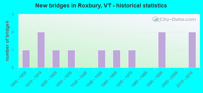
- New bridges - historical statistics
- 11900-1909
- 21910-1919
- 11920-1929
- 11930-1939
- 11950-1959
- 11960-1969
- 11970-1979
- 21990-1999
- 22010-2019
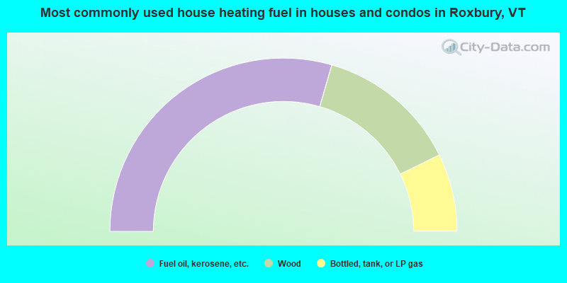
- 59.0%Fuel oil, kerosene, etc.
- 26.5%Wood
- 14.5%Bottled, tank, or LP gas
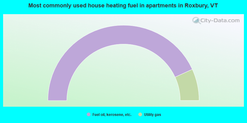
- 86.4%Fuel oil, kerosene, etc.
- 13.6%Utility gas
Roxbury compared to Vermont state average:
- Unemployed percentage below state average.
- Black race population percentage below state average.
- Hispanic race population percentage below state average.
- Foreign-born population percentage below state average.
- Renting percentage below state average.
- Length of stay since moving in significantly above state average.
- Number of rooms per house significantly below state average.
- House age significantly below state average.

|
Total of 1 patent application in 2008-2024.