Please register to participate in our discussions with 2 million other members - it's free and quick! Some forums can only be seen by registered members. After you create your account, you'll be able to customize options and access all our 15,000 new posts/day with fewer ads.
Snow's coming down good here. Everything getting covered. The road is now completely covered as of 5:40pm. At 5:00 PM you could barely tell it was snowing yet.
Pittsburgh, as of 17:00, picked up 2.6"/6.6 cm today. A HUGE relief from the ice-covered snowpack from last Tuesday night to yesterday. Seasonal total now 49.6"/126.0 cm, exactly 2 feet/61 cm above normal. We have a shot at 0F both Monday and Tuesday night. NWS
Want spring?? Simple... Get that Upper level low to park itself East more. All winter it's been just sitting there, helping pump the western ridge up which in turn brings a northwesterly flow into the U.S. Now we have an active sub jet past week+ so when you get polar disturbances to interact with the subjet moisture with a northwest flow, it equals what we been seeing...snow.
So if you want this to end, pray that ULL shifts East towards British Columbia. That will bring a progressive pattern in play and bring warm Pacific air right into the entire U.S and we warm up.
I personally believe this will happen after the 22nd of February.
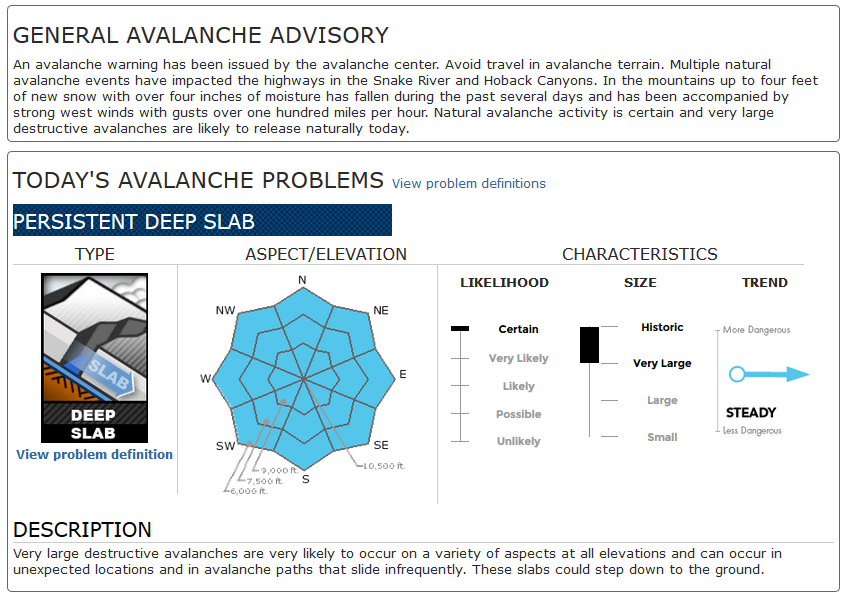
The highway was closed for about 14 hours for avalanche work. The WYDOT crew does a great job keeping the pass safe and open. We only saw a little more snow overnight, about 7", and the total is at 260".
Snow depth in and around Chicagoland 33cm in the city, and as high as 51cm in some suburban stations. My suburb is at 31cm
Last edited by chicagogeorge; 02-09-2014 at 08:42 PM..
Please register to post and access all features of our very popular forum. It is free and quick. Over $68,000 in prizes has already been given out to active posters on our forum. Additional giveaways are planned.
Detailed information about all U.S. cities, counties, and zip codes on our site: City-data.com.

 Please register to participate in our discussions with 2 million other members - it's free and quick! Some forums can only be seen by registered members. After you create your account, you'll be able to customize options and access all our 15,000 new posts/day with fewer ads.