Please register to participate in our discussions with 2 million other members - it's free and quick! Some forums can only be seen by registered members. After you create your account, you'll be able to customize options and access all our 15,000 new posts/day with fewer ads.
Early season snowstorm in Sierra of California down to 6000'. ..
515 PM PDT SAT SEP 21 2013
...WINTER WEATHER ADVISORY IN EFFECT UNTIL 11 PM PDT THIS EVENING ABOVE 6000 FEET FOR THE WEST SLOPES OF THE SIERRA NEVADA...
AN EARLY SEASON STORM IS BRINGING SNOW AS LOW AT 6000 FEET TO THE SIERRA NEVADA. SEVERAL INCHES OF SNOW IS EXPECTED TO CAUSE TRAVEL DIFFICULTIES THIS EVENING FOR TRAVELERS ON I-80 AND US-50.
* SNOW ACCUMULATIONS: UP TO 3 INCHES.
* ELEVATION: ABOVE 6000 FEET.
* TIMING: THROUGH THIS EVENING.
* IMPACTS: TRAVEL DIFFICULTIES. SLIPPERY ROADS AND POOR VISIBILITY
That's fantastic 5 inches of snow at that latitude in September - although the snow does look very very wet. It is still pretty high, I suppose you could live in that area of america pretty high up and get a very snowy winter but still be close to the hot deserts.
This is the 8th cold front that came through since Mid August in the East and many dropped all the way down south. It's 40s this morning down in Oklahoma and Arkansas this morning which is about 10 below normal. Even a cold front sliding down in the West too.
odd. I thought it was going to be heavy rain all day. We got almost an inch of rain overnight, I slept right through it.
Front was faster. We're in a progressive pattern. (in and out). Front was supposed to come through this afternoon but it was 12hrs earlier. Hence the heavier rains overnight instead of today. Nice Fall day today. Clear Blue, cool, and dry. Cold tonight and tomorrow night. More frost potential. Then warm up end of week. Then another cold front next weekend. We need some blocking to slow the flow down.
One model has Washington DC, Tuesday Morning at about 42°F
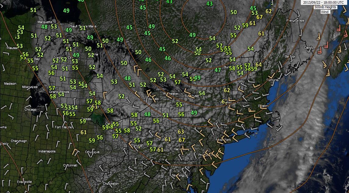
Take a look at the 500mb heights. Closed Upper Level low has formed over Canada and guess what happens because of the Negative NAO? Its blocked from moving out so it lingers and spins in the upper atmosphere.
Upper Level Lows keep the surface cool and cloudy. I'm hoping this trend is the beginning and we see more of these forming and getting stuck just south more.
.LONG TERM /MONDAY NIGHT THROUGH SATURDAY/... UPPER LEVEL BLOCKED ACROSS THE CANADIAN MARITIMES THROUGH MID WEEK.
THERE WILL BE A SPLIT IN THE FLOW WITH A WEAKENING RIDGE MOVING
ACROSS THE REGION FROM EARLY TO MID WEEK WITH CANADIAN HIGH PRESSURE
BUILDING IN AT THE SURFACE. THEN A DAMPENED UPPER LEVEL SHORTWAVE
PUSHES TO THE SOUTH OF THE REGION WEDNESDAY AND THURSDAY WITH A
WEAKENING OF THE SURFACE PRESSURE FIELD. THIS WILL RESULT IN SOME
MORE CLOUDS FOR THAT TIME FRAME
Nice Fall like N/NW winds. Afternoon temps in the 50s & even 40s in spots.
68°F here
Please register to post and access all features of our very popular forum. It is free and quick. Over $68,000 in prizes has already been given out to active posters on our forum. Additional giveaways are planned.
Detailed information about all U.S. cities, counties, and zip codes on our site: City-data.com.

 Please register to participate in our discussions with 2 million other members - it's free and quick! Some forums can only be seen by registered members. After you create your account, you'll be able to customize options and access all our 15,000 new posts/day with fewer ads.