Please register to participate in our discussions with 2 million other members - it's free and quick! Some forums can only be seen by registered members. After you create your account, you'll be able to customize options and access all our 15,000 new posts/day with fewer ads.
Hey Cambium, forgive me if you posted it already, but what is causing the big chill in the Northeast and the subsequent mid-week roastfest from Harrisburg to Portland? NWS is forecasting 90°F for my area
NWS Boston which covers northern CT, MA, and southern NH
" WEDNESDAY/WEDNESDAY NIGHT...WED WILL REMIND US THAT IT IS STILL SUMMER. WITH +19C 850 TEMPS...A GOOD DEAL OF SUNSHINE...AND SOUTHWEST FLOW CONTINUING...EXPECT HIGH TEMPERATURES TO REACH 85 TO 90 ACROSS THE INTERIOR. COOLER AT THE IMMEDIATE COAST AND 75 TO 80 ON THE ISLANDS. WARM 700 MB TEMPS REMAIN AND THUS AM NOT EXPECTING WIDESPREAD CONVECTION"
Hey Cambium, forgive me if you posted it already, but what is causing the big chill in the Northeast and the subsequent mid-week roastfest from Harrisburg to Portland? NWS is forecasting 90°F for my area
The swings are WILD!
NAM18z had done it again for Wednesday. This would be insane. 97°F NYC metro?
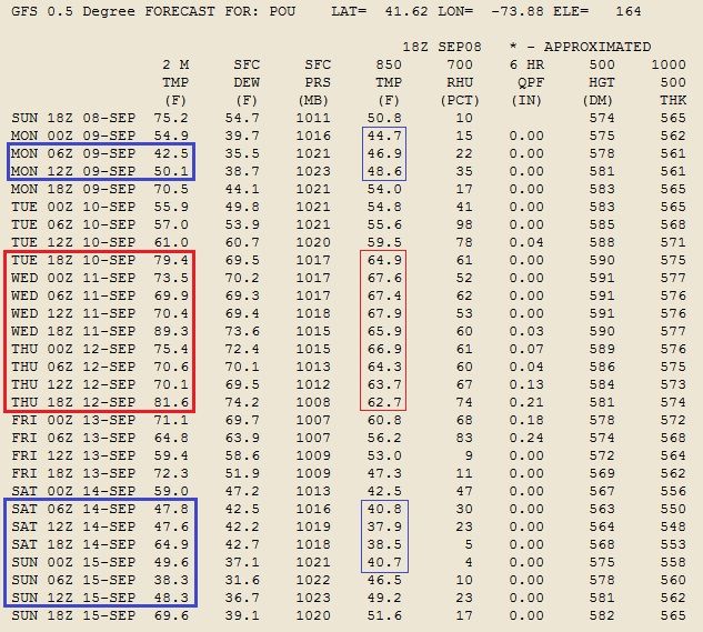
GFS isn't as warm but check out the latest data for Poughkeepsie, NY. The actual highs and lows would be a bit higher and lower than whats shown here.
As far as why, Its the Canadien Highs/ cold fronts / northwest flow VS the Jet stream pulling back north creating a return south flow pushing the warm air up from south. Mid levels warming up as well.
Please register to post and access all features of our very popular forum. It is free and quick. Over $68,000 in prizes has already been given out to active posters on our forum. Additional giveaways are planned.
Detailed information about all U.S. cities, counties, and zip codes on our site: City-data.com.

 Please register to participate in our discussions with 2 million other members - it's free and quick! Some forums can only be seen by registered members. After you create your account, you'll be able to customize options and access all our 15,000 new posts/day with fewer ads.


") . That map says I'm gonna be 93 degrees, NWS says I'm gonna have 90 for a high.
. That map says I'm gonna be 93 degrees, NWS says I'm gonna have 90 for a high.