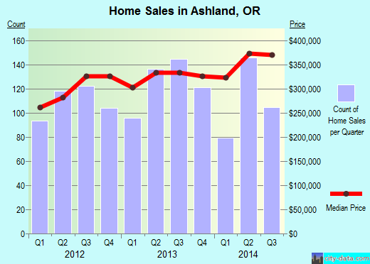
Property valuation of Hwy 66, Ashland, OR: 7528, 7528, 7528, 7528, 7528, 7528, 7583, 7583, 7603, 7701 (tax assessments)

Listed properties vs overall distribution of properties in Ashland, OR:
Advertisements
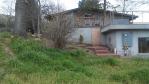
7528 Hwy 66
Ashland, OR
Find on map >>
Owner: LOUISE L GUND
Land market value: $31,880 (it was $24,560 in 2011)
Total market value for property: $31,880 (it was $24,560 in 2011)
Assessments for tax year: 2016
Property use: Residence - Bare Land
Property class: Improved H&b Use Farm, Rcvg Farm Def, Zoned Efu
Land size: 202,554 square feet
Zoning: County- Exclusive Farm Use
Recent sale: $435,000 (2/28/1990)
7528 Hwy 66
Ashland, OR
Find on map >>
Owner: LOUISE L GUND
Land market value: $108,510 (it was $94,710 in 2011)
Total market value for property: $108,510 (it was $94,710 in 2011)
Assessments for tax year: 2016
Property use: Residence - Bare Land
Property class: Vacant H&b Use Tract Land, Zoning Not Significant
Land size: 3,223,440 square feet
Zoning: County- Exclusive Farm Use
Recent sale: $277,500 (6/23/1992)
7528 Hwy 66
Ashland, OR
Find on map >>
Owner: LOUISE L GUND
Land market value: $118,490 (it was $103,410 in 2011)
Total market value for property: $118,490 (it was $103,410 in 2011)
Assessments for tax year: 2016
Property use: Residence - Bare Land
Property class: Vacant H&b Use Farm, Recvng Farm Def, Zoned Efu
Land size: 1,005,364 square feet
Zoning: County- Exclusive Farm Use
Recent sale: $435,000 (2/28/1990)
7528 Hwy 66
Ashland, OR
Find on map >>
Owner: LOUISE L GUND
Land market value: $105,230 (it was $91,860 in 2011)
Total market value for property: $105,230 (it was $91,860 in 2011)
Assessments for tax year: 2016
Property use: Residence - Bare Land
Property class: Improved H&b Use Farm, Rcvg Farm Def, Zoned Efu
Land size: 1,306,800 square feet
Zoning: County- Exclusive Farm Use
Recent sale: $435,000 (2/28/1990)
7528 Hwy 66
Ashland, OR
Find on map >>
Owner: LOUISE L GUND
Land market value: $291,630 (it was $254,550 in 2011)
Improvements market value: $216,190 (it was $203,210 in 2011)
Total market value for property: $507,820 (it was $457,760 in 2011)
Assessments for tax year: 2016
Property use: Residence - Two Story
Property class: Improved H&b Use Farm, Rcvg Farm Def, Zoned Efu
Land size: 1,200,949 square feet
Total improvements area: 2,600 square feet
Zoning: County- Exclusive Farm Use
Recent sale: $435,000 (2/28/1990)
Improvements:
- Type: Residence
Description: Two story
Area: 2,600 square feet
Year built: 1976
Effective year built: 1976
7528 Hwy 66
Ashland, OR
Find on map >>
Owner: LOUISE L GUND
Land market value: $80,020 (it was $69,850 in 2011)
Improvements market value: $43,460 (it was $38,250 in 2011)
Total market value for property: $123,480 (it was $108,100 in 2011)
Assessments for tax year: 2016
Property use: Residence - Residential Other Improvements
Property class: Improved H&b Use Farm, Rcvg Farm Def, Zoned Efu
Land size: 496,584 square feet
Zoning: County- Exclusive Farm Use
Recent sale: $435,000 (2/28/1990)
Improvements:
- Type: Residence
Description: Residential Other Improvements
Effective year built: 2000
7583 Hwy 66
Ashland, OR
Find on map >>
Owner: NIKKI HELVEY
Assessments for tax year: 2016
Property class: Improved H&b Use Tract, Zoning Not Significant
Total improvements area: 940 square feet
Zoning: County-Rural Residential 5 Acres
Improvements:
Ashland, OR
Find on map >>
Owner: NIKKI HELVEY
Assessments for tax year: 2016
Property class: Improved H&b Use Tract, Zoning Not Significant
Total improvements area: 940 square feet
Zoning: County-Rural Residential 5 Acres
Improvements:
- Type: Manf Strct
Description: Single wide
Area: 940 square feet
Year built: 1965
Effective year built: 1965
7583 Hwy 66
Ashland, OR
Find on map >>
Owner: JEFFREY BEHRENDS & INGRID EDSTROM
Land market value: $234,640 (it was $204,810 in 2011)
Improvements market value: $104,780 (it was $7,580 in 2011)
Total market value for property: $339,420 (it was $212,390 in 2011)
Assessments for tax year: 2016
Property use: Residence - One Story
Property class: Improved H&b Use Tract, Zoning Not Significant
Land size: 87,120 square feet
Total improvements area: 1,746 square feet
Zoning: County-Rural Residential 5 Acres
Improvements:
- Type: Residence
Description: One story
Area: 1,746 square feet
Year built: 1960
Effective year built: 1990
7603 Hwy 66
Ashland, OR
Find on map >>
Owner: JOHN M ARCHER TRUSTEE & HELENE L ARCHER TRUSTEE & JOHN ARCHER & HELENE TRUST
Land market value: $248,070 (it was $212,230 in 2011)
Improvements market value: $114,820 (it was $107,860 in 2011)
Total market value for property: $362,890 (it was $320,090 in 2011)
Assessments for tax year: 2016
Property use: Residence - Two Story
Property class: Improved H&b Use Tract, Zoning Not Significant
Land size: 159,865 square feet
Total improvements area: 2,360 square feet
Zoning: County-Rural Residential 5 Acres
Improvements:
- Type: Residence
Description: Two story
Area: 2,360 square feet
Year built: 1950
Effective year built: 1974
7701 Hwy 66
Ashland, OR
Find on map >>
Owner: EMIGRANT RANCH INC
Land market value: $452,360 (it was $381,070 in 2011)
Improvements market value: $362,090 (it was $36,880 in 2011)
Total market value for property: $814,450 (it was $417,950 in 2011)
Assessments for tax year: 2016
Property use: Residence - One Story
Property class: Improved H&b Use Farm, Rcvg Farm Def, Zoned Efu
Land size: 1,842,587 square feet
Total improvements area: 6,143 square feet
Zoning: County- Exclusive Farm Use
Recent sale: $575,000 (11/15/1991)
Improvements:
- Type: Residence
Description: One story
Area: 2,919 square feet
Year built: 2014
Effective year built: 2014
- Type: Farm Bldg
Description: Arena
Area: 3,224 square feet
Year built: 2014
Effective year built: 2014

Recent posts about Ashland, Oregon on our local forum with over 2,400,000 registered users. Ashland is mentioned 4,752 times on our forum:
 | Smoke Gets In My Eyes...Is Ashland Still A Viable Move? (24 replies) |
| Living In Lake Oswego But Love Ashland (2 replies) |
| Yes, I know....Retirement in Ashland (76 replies) |
| Retirement in Ashland (24 replies) |
| Ashland have a shortage of Doctors? (3 replies) |
| Snow in Ashland, Oregon (50 replies) |
Settings
X

Recently Added Photos
Ashland, OR

West Linn, OR

Milwaukie, OR

Eagle Point, OR

Sweet Home, OR

Eugene, OR

Milwaukie, OR

Milwaukie, OR

Albany, OR

Milwaukie, OR

Gresham, OR

Milwaukie, OR
Request disassociating your name from street-level assessment address

Recent home sales, price trends, and home value evaluator powered by Onboard Informatics
© 2024 Onboard Informatics. Information is deemed reliable but not guaranteed.
© 2024 Onboard Informatics. Information is deemed reliable but not guaranteed.
Some parts © 2024 Advameg, Inc.
Compilation, repackaging, or reproduction prohibited. Users are forewarned that it is incumbent upon them to verify information with the responsible state agency. Advameg, Inc. does not guarantee the data presented is up-to-date nor does it assume responsibility for updating it. Therefore any names, owners or addresses may have changed. Use of any information published here to contact the persons might be prohibited by the law.