Property valuation of Siskiyou Highway, Ashland, OR (tax assessments)
Other nearby streets: Old Hwy 99  Siskiyou Highway (1)
Siskiyou Highway (2)
Siskiyou Highway (3)
Siskiyou Highway (4)
Siskiyou Highway (1)
Siskiyou Highway (2)
Siskiyou Highway (3)
Siskiyou Highway (4)
Siskiyou Highway (1)
Siskiyou Highway (2)
Siskiyou Highway (3)
Siskiyou Highway (4)
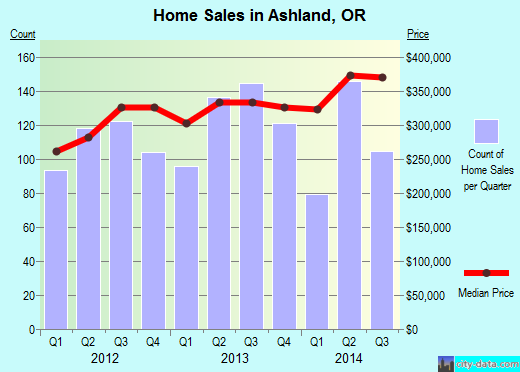
Listed properties vs overall distribution of properties in Ashland, OR:
Advertisements
Siskiyou Highway
Ashland, OR
Find on map >>
Owner: ATTA LOIS JANE VAN
Land market value: $12,440 (it was $10,860 in 2011)
Total market value for property: $12,440 (it was $10,860 in 2011)
Assessments for tax year: 2016
Property use: Residence - Bare Land
Property class: Improved H&b Use Tract, Zoning Not Significant
Land size: 19,166 square feet
Zoning: County-Rural Residential 5 Acres
Siskiyou Highway
Ashland, OR
Find on map >>
Owner: LIVING GRADY TRUST & DEIRDRE BETH GRADY TRUSTEE
Land market value: $64,110 (it was $55,950 in 2011)
Total market value for property: $64,110 (it was $55,950 in 2011)
Assessments for tax year: 2016
Property use: Residence - Bare Land
Property class: Vacant H&b Use Forest, Not Designated, Zoning Not Significant
Land size: 721,353 square feet
Zoning: County-Woodland Resource
Recent sale: $37,500 (3/28/1991)
Siskiyou Highway
Ashland, OR
Find on map >>
Owner: D J MAULSBY & BONNIE MAULSBY
Land market value: $1,000
Total market value for property: $1,000
Assessments for tax year: 2016
Property use: Residence - Bare Land
Property class: Misc Tract Unbuildable
Land size: 6,534 square feet
Zoning: County-Woodland Resource
Ashland, OR
Find on map >>
Owner: D J MAULSBY & BONNIE MAULSBY
Land market value: $1,000
Total market value for property: $1,000
Assessments for tax year: 2016
Property use: Residence - Bare Land
Property class: Misc Tract Unbuildable
Land size: 6,534 square feet
Zoning: County-Woodland Resource
Siskiyou Highway
Ashland, OR
Find on map >>
Owner: BARBARA J BARATS TRUSTEE & BARBARA J BARATS TRUST
Land market value: $9,150 (it was $30,240 in 2011)
Total market value for property: $9,150 (it was $30,240 in 2011)
Assessments for tax year: 2016
Property use: Residence - Bare Land
Property class: Vacant H&b Use Forest, Not Designated, Zoning Not Significant
Land size: 388,555 square feet
Zoning: County-Forest Resource
Recent sale: $5,280 (8/12/1994)
Siskiyou Highway
Ashland, OR
Find on map >>
Owner: GILBERT NORMAN
Land market value: $24,480 (it was $21,370 in 2011)
Total market value for property: $24,480 (it was $21,370 in 2011)
Assessments for tax year: 2016
Property use: Residence - Bare Land
Property class: Vacant H&b Use Tract Land, Zoning Not Significant
Land size: 1,118,620 square feet
Zoning: County-Woodland Resource
Siskiyou Highway
Ashland, OR
Find on map >>
Owner: DANNY RAY GUNTER
Land market value: $5,050 (it was $4,470 in 2011)
Total market value for property: $5,050 (it was $4,470 in 2011)
Assessments for tax year: 2016
Property use: Residence - Bare Land
Property class: Vacant H&b Use Forest, Not Designated, Zoning Not Significant
Land size: 1,693,612 square feet
Zoning: County-Forest Resource
Siskiyou Highway
Ashland, OR
Find on map >>
Owner: LIVING TRUST & RICHARD R/HELEN J REV HEIN & HELEN J FBO HEIN TRUSTEE & RICHARD R HEIN TRUSTEE
Land market value: $21,150 (it was $18,760 in 2011)
Total market value for property: $21,150 (it was $18,760 in 2011)
Assessments for tax year: 2016
Property use: Residence - Bare Land
Property class: Vacant H&b Use Forest, Not Designated, Zoning Not Significant
Land size: 2,971,663 square feet
Zoning: County-Forest Resource
Recent sale: $30,000 (10/4/1996)
Siskiyou Highway
Ashland, OR
Find on map >>
Owner: MOUNTCREST FOREST LLC
Land market value: $471,210 (it was $410,640 in 2011)
Total market value for property: $471,210 (it was $410,640 in 2011)
Assessments for tax year: 2016
Property use: Residence - Bare Land
Property class: Vacant H&b Use Forest, Not Designated, Zoning Not Significant
Land size: 67,421,296 square feet
Zoning: County-Forest Resource
Siskiyou Highway
Ashland, OR
Find on map >>
Owner: CREEK TIMBERLANDS LP PLUM
Land market value: $118,280 (it was $103,540 in 2011)
Total market value for property: $118,280 (it was $103,540 in 2011)
Assessments for tax year: 2016
Property use: Residence - Bare Land
Property class: Vacant H&b Use Forest, Not Designated, Zoning Not Significant
Land size: 13,001,353 square feet
Zoning: County-Forest Resource
Siskiyou Highway
Ashland, OR
Find on map >>
Owner: S U A
Land market value: $90,680 (it was $5,620 in 2011)
Total market value for property: $90,680 (it was $5,620 in 2011)
Assessments for tax year: 2016
Property use: Residence - Bare Land
Property class: Federally Owned - Vacant
Land size: 3,494,818 square feet
Zoning: County-Forest Resource
Other nearby streets: Old Hwy 99
Siskiyou Highway (1)
Siskiyou Highway (2)
Siskiyou Highway (3)
Siskiyou Highway (4)
Siskiyou Highway (1)
Siskiyou Highway (2)
Siskiyou Highway (3)
Siskiyou Highway (4)

Recent posts about Ashland, Oregon on our local forum with over 2,400,000 registered users. Ashland is mentioned 4,752 times on our forum:
 | Smoke Gets In My Eyes...Is Ashland Still A Viable Move? (24 replies) |
| Living In Lake Oswego But Love Ashland (2 replies) |
| Yes, I know....Retirement in Ashland (76 replies) |
| Retirement in Ashland (24 replies) |
| Ashland have a shortage of Doctors? (3 replies) |
| Snow in Ashland, Oregon (50 replies) |
Settings
X

Recently Added Photos
Ashland, OR

West Linn, OR

Milwaukie, OR

Eagle Point, OR

Sweet Home, OR

Eugene, OR

Milwaukie, OR

Milwaukie, OR

Albany, OR

Milwaukie, OR

Gresham, OR

Milwaukie, OR
Request disassociating your name from street-level assessment address

Recent home sales, price trends, and home value evaluator powered by Onboard Informatics
© 2024 Onboard Informatics. Information is deemed reliable but not guaranteed.
© 2024 Onboard Informatics. Information is deemed reliable but not guaranteed.
Some parts © 2024 Advameg, Inc.
Compilation, repackaging, or reproduction prohibited. Users are forewarned that it is incumbent upon them to verify information with the responsible state agency. Advameg, Inc. does not guarantee the data presented is up-to-date nor does it assume responsibility for updating it. Therefore any names, owners or addresses may have changed. Use of any information published here to contact the persons might be prohibited by the law.