Campbellton, Texas
Submit your own pictures of this place and show them to the world
- OSM Map
- General Map
- Google Map
- MSN Map

| Males: 278 | |
| Females: 283 |
| Median resident age: | 38.7 years |
| Texas median age: | 32.3 years |
Zip code: 78008
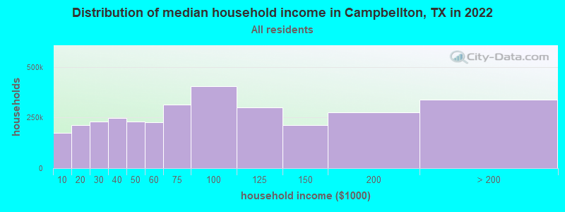
| Campbellton: | $45,960 |
| TX: | $72,284 |
Estimated per capita income in 2022: $24,421 (it was $12,527 in 2000)
Campbellton CCD income, earnings, and wages data
Estimated median house or condo value in 2022: $122,368 (it was $36,600 in 2000)
| Campbellton: | $122,368 |
| TX: | $275,400 |
Mean prices in 2022: all housing units: $205,108; detached houses: $251,904; townhouses or other attached units: $159,730; mobile homes: $124,998; occupied boats, rvs, vans, etc.: $135,268
Detailed information about poverty and poor residents in Campbellton, TX
Compare current foreclosures near Campbellton, TX:
| Photo | Address | Area | Beds / Baths | Price | Details |
|---|---|---|---|---|---|

|
#1
Fm 673
Pawnee, TX 78145
|
1,356 sq. feet
|
2 baths 4 beds |
show details | |

|
Check over 1 million property listings on Foreclosure.com!
|
browse all offers | |||

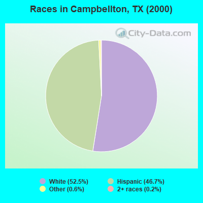
- 26352.5%White alone
- 23446.7%Hispanic
- 30.6%Other race alone
- 10.2%Two or more races
Races in Campbellton detailed stats: ancestries, foreign born residents, place of birth
 Recent articles from our blog. Our writers, many of them Ph.D. graduates or candidates, create easy-to-read articles on a wide variety of topics.
Current Local Time: CST time zone
Elevation: 241 feet
Land area: 198.5 square miles.
Population density: 2.8 people per square mile (very low).

| Campbellton CCD: | 0.9% ($333) |
| Texas: | 1.8% ($1,393) |
Nearest city with pop. 50,000+: San Antonio, TX  (50.4 miles , pop. 1,144,646).
Nearest cities:
), ), Latitude: 28.76 N, Longitude: 98.26 W
Area code: 830

| Here: | 3.4% |
| Texas: | 3.5% |
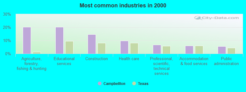
- Agriculture, forestry, fishing & hunting (20.2%)
- Educational services (20.2%)
- Construction (14.7%)
- Health care (9.8%)
- Professional, scientific, technical services (6.7%)
- Accommodation & food services (6.1%)
- Public administration (5.5%)
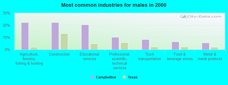
- Agriculture, forestry, fishing & hunting (22.2%)
- Construction (22.2%)
- Educational services (20.4%)
- Professional, scientific, technical services (10.2%)
- Truck transportation (8.3%)
- Food & beverage stores (6.5%)
- Metal & metal products (5.6%)
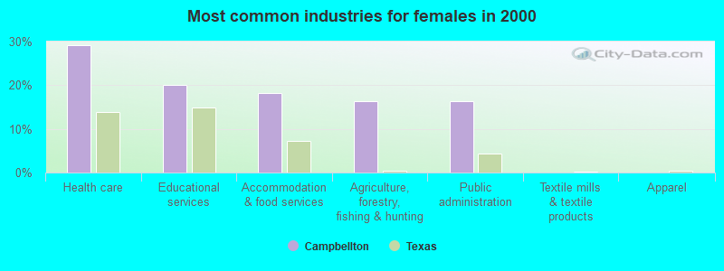
- Health care (29.1%)
- Educational services (20.0%)
- Accommodation & food services (18.2%)
- Agriculture, forestry, fishing & hunting (16.4%)
- Public administration (16.4%)
- Textile mills & textile products (0.0%)
- Apparel (0.0%)
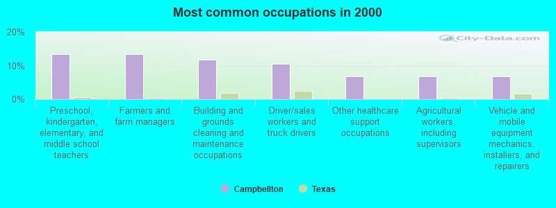
- Preschool, kindergarten, elementary, and middle school teachers (13.5%)
- Farmers and farm managers (13.5%)
- Building and grounds cleaning and maintenance occupations (11.7%)
- Driver/sales workers and truck drivers (10.4%)
- Other healthcare support occupations (6.7%)
- Agricultural workers, including supervisors (6.7%)
- Vehicle and mobile equipment mechanics, installers, and repairers (6.7%)
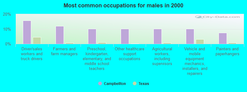
- Driver/sales workers and truck drivers (15.7%)
- Farmers and farm managers (12.0%)
- Preschool, kindergarten, elementary, and middle school teachers (10.2%)
- Other healthcare support occupations (10.2%)
- Agricultural workers, including supervisors (10.2%)
- Vehicle and mobile equipment mechanics, installers, and repairers (10.2%)
- Painters and paperhangers (7.4%)
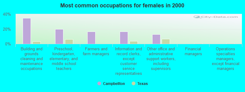
- Building and grounds cleaning and maintenance occupations (34.5%)
- Preschool, kindergarten, elementary, and middle school teachers (20.0%)
- Farmers and farm managers (16.4%)
- Information and record clerks, except customer service representatives (16.4%)
- Other office and administrative support workers, including supervisors (12.7%)
- Financial managers (0.0%)
- Operations specialties managers, except financial managers (0.0%)
Average climate in Campbellton, Texas
Based on data reported by over 4,000 weather stations


Tornado activity:
Campbellton-area historical tornado activity is below Texas state average. It is 20% smaller than the overall U.S. average.
On 4/15/1973, a category F4 (max. wind speeds 207-260 mph) tornado 35.0 miles away from the Campbellton place center killed 5 people and injured 12 people.
On 4/25/1966, a category F3 (max. wind speeds 158-206 mph) tornado 23.8 miles away from the place center injured 3 people and caused between $50,000 and $500,000 in damages.
Earthquake activity:
Campbellton-area historical earthquake activity is significantly above Texas state average. It is 34% smaller than the overall U.S. average.On 10/20/2011 at 12:24:41, a magnitude 4.8 (4.8 MW, Depth: 3.1 mi, Class: Light, Intensity: IV - V) earthquake occurred 13.1 miles away from the city center
On 4/9/1993 at 12:29:19, a magnitude 4.3 (4.1 MB, 4.3 LG, Depth: 3.1 mi) earthquake occurred 8.8 miles away from the city center
On 4/14/1995 at 00:32:56, a magnitude 5.7 (5.6 MB, 5.7 MS, 5.7 MW, Depth: 11.1 mi, Class: Moderate, Intensity: VI - VII) earthquake occurred 325.1 miles away from Campbellton center
On 5/1/2018 at 16:28:56, a magnitude 4.0 (4.0 MW, Depth: 3.1 mi) earthquake occurred 20.3 miles away from Campbellton center
On 4/7/2008 at 09:51:12, a magnitude 3.9 (3.9 MW, Depth: 3.1 mi, Class: Light, Intensity: II - III) earthquake occurred 17.4 miles away from Campbellton center
On 6/16/1978 at 11:46:54, a magnitude 5.3 (4.4 MB, 4.6 UK, 5.3 ML) earthquake occurred 330.9 miles away from the city center
Magnitude types: regional Lg-wave magnitude (LG), body-wave magnitude (MB), local magnitude (ML), surface-wave magnitude (MS), moment magnitude (MW)
Natural disasters:
The number of natural disasters in Atascosa County (14) is near the US average (15).Major Disasters (Presidential) Declared: 8
Emergencies Declared: 5
Causes of natural disasters: Hurricanes: 5, Storms: 5, Floods: 4, Tornadoes: 4, Fires: 2, Tropical Storm: 1, Wind: 1, Other: 1 (Note: some incidents may be assigned to more than one category).
Airports located in Campbellton:
- 74 Ranch Airport (0XA5) (Runways: 1)
Colleges/universities with over 2000 students nearest to Campbellton:
- Coastal Bend College (about 38 miles; Beeville, TX; Full-time enrollment: 2,880)
- Palo Alto College (about 43 miles; San Antonio, TX; FT enrollment: 5,055)
- St Philip's College (about 47 miles; San Antonio, TX; FT enrollment: 5,970)
- Our Lady of the Lake University (about 50 miles; San Antonio, TX; FT enrollment: 2,133)
- San Antonio College (about 50 miles; San Antonio, TX; FT enrollment: 15,182)
- Trinity University (about 51 miles; San Antonio, TX; FT enrollment: 2,467)
- University of the Incarnate Word (about 51 miles; San Antonio, TX; FT enrollment: 6,875)
Points of interest:
Notable locations in Campbellton: Hacienda de la Tordilla (A), Tom Ranch (B). Display/hide their locations on the map
Cemeteries: Campbellton Cemetery (1), Brister Cemetery (2), Fashing Cemetery (3). Display/hide their locations on the map
Lakes and reservoirs: Goose Lake (A), Tom Ranch Lake Number 2 (B), Tom Ranch Lake Number 1 (C), Lazy JP Ranch Lake (D), Lake Number 2 (E), Lake Number 1 (F), Big Lake (G). Display/hide their locations on the map
Creeks: Borrego Creek (A), West Olmos Creek (B), Water Creek (C), Christine Creek (D), Sulphur Creek (E), Tordillo Creek (F), Post Oak Creek (G), Los Cortes Creek (H), Logan Creek (I). Display/hide their locations on the map
| This place: | 2.3 people |
| Texas: | 2.8 people |
| This place: | 67.7% |
| Whole state: | 69.9% |
| This place: | 4.5% |
| Whole state: | 6.0% |
Likely homosexual households (counted as self-reported same-sex unmarried-partner households)
- Lesbian couples: 0.9% of all households
- Gay men: 0.0% of all households
| This place: | 40.9% |
| Whole state: | 15.4% |
| This place: | 10.6% |
| Whole state: | 6.7% |
For population 15 years and over in Campbellton:
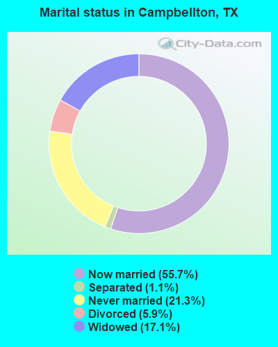
- Never married: 21.3%
- Now married: 55.7%
- Separated: 1.1%
- Widowed: 17.1%
- Divorced: 5.9%
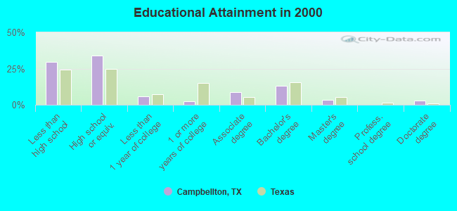
For population 25 years and over in Campbellton:
- High school or higher: 70.5%
- Bachelor's degree or higher: 19.7%
- Graduate or professional degree: 6.6%
- Unemployed: 4.1%
- Mean travel time to work (commute): 34.2 minutes
| Here: | 18.6 |
| Texas average: | 15.6 |
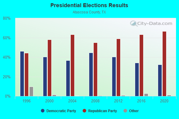
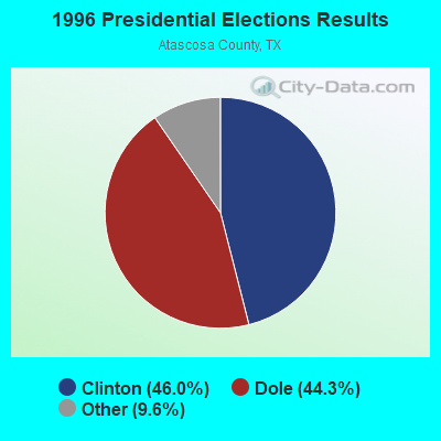
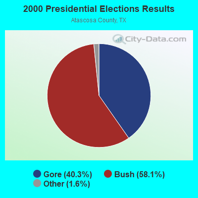
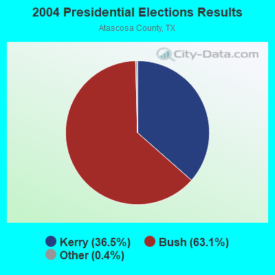

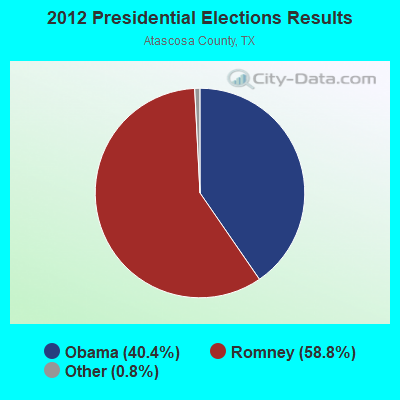
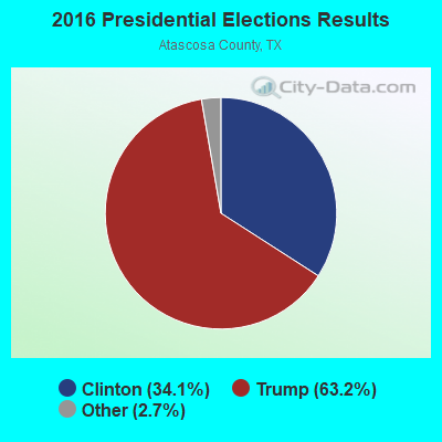
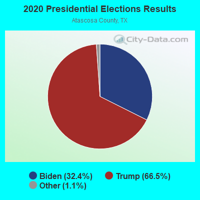
Graphs represent county-level data. Detailed 2008 Election Results
Religion statistics for Campbellton, TX (based on Atascosa County data)
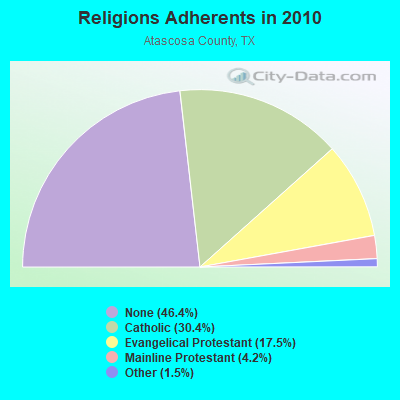
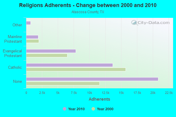
| Religion | Adherents | Congregations |
|---|---|---|
| Catholic | 13,637 | 10 |
| Evangelical Protestant | 7,844 | 49 |
| Mainline Protestant | 1,888 | 9 |
| Other | 694 | 4 |
| None | 20,848 | - |
Food Environment Statistics:
| Atascosa County: | 1.15 / 10,000 pop. |
| Texas: | 1.47 / 10,000 pop. |
| Atascosa County: | 0.23 / 10,000 pop. |
| Texas: | 0.14 / 10,000 pop. |
| Here: | 2.07 / 10,000 pop. |
| Texas: | 1.11 / 10,000 pop. |
| This county: | 4.37 / 10,000 pop. |
| Texas: | 3.95 / 10,000 pop. |
| Here: | 6.21 / 10,000 pop. |
| State: | 6.13 / 10,000 pop. |
| This county: | 8.9% |
| State: | 8.9% |
| This county: | 26.6% |
| State: | 26.6% |
| This county: | 15.0% |
| Texas: | 15.7% |
Strongest AM radio stations in Campbellton:
- KTKR (760 AM; 50 kW; SAN ANTONIO, TX; Owner: CCB TEXAS LICENSES, L.P.)
- KKYX (680 AM; 50 kW; SAN ANTONIO, TX; Owner: CXR HOLDINGS, INC.)
- WOAI (1200 AM; 50 kW; SAN ANTONIO, TX; Owner: CCB TEXAS LICENSES, L.P.)
- KCTA (1030 AM; 50 kW; CORPUS CHRISTI, TX; Owner: BROADCASTING CORPORATION OF THE SOUTHWEST)
- KENS (1160 AM; 25 kW; SAN ANTONIO, TX; Owner: KENS-TV, INC.)
- KFNI (1380 AM; 4 kW; PLEASANTON, TX; Owner: WAY BROADCASTING, INC.)
- KSAH (720 AM; 10 kW; UNIVERSAL CITY, TX; Owner: KSAH LICENSING, INC.)
- KSLR (630 AM; 5 kW; SAN ANTONIO, TX; Owner: SALEM MEDIA OF TEXAS, INC.)
- KDRY (1100 AM; 11 kW; ALAMO HEIGHTS, TX; Owner: KDRY RADIO, INC.)
- KTSA (550 AM; 5 kW; SAN ANTONIO, TX; Owner: INFINITY BROADCASTING CORPORATION OF SAN ANTONIO)
- KONO (860 AM; 5 kW; SAN ANTONIO, TX; Owner: CXR HOLDINGS, INC.)
- KVOZ (890 AM; 12 kW; DEL MAR HILLS, TX; Owner: CONSOLIDATED RADIO, INC.)
- KEDA (1540 AM; 5 kW; SAN ANTONIO, TX; Owner: D & E BROADCASTING CO., INC.)
Strongest FM radio stations in Campbellton:
- KEMA (94.5 FM; THREE RIVERS, TX; Owner: ROY E. HENDERSON)
- KBBT (98.5 FM; SCHERTZ, TX; Owner: HBC LICENSE CORPORATION)
- KXTN-FM (107.5 FM; SAN ANTONIO, TX; Owner: TICHENOR LICENSE CORPORATION ("TLC"))
- KROM (92.9 FM; SAN ANTONIO, TX; Owner: TICHENOR LICENSE CORPORATION ("TLC"))
- KSMG (105.3 FM; SEGUIN, TX; Owner: CXR HOLDINGS, INC.)
- KMFR (104.1 FM; PEARSALL, TX; Owner: RADIO TUNA, LTD.)
- KCJZ (106.7 FM; TERRELL HILLS, TX; Owner: CXR HOLDINGS, INC.)
- KISS-FM (99.5 FM; SAN ANTONIO, TX; Owner: CXR HOLDINGS, INC.)
- KLEY-FM (94.1 FM; FLORESVILLE, TX; Owner: KLEY LICENSING, INC.)
- KBUC (95.7 FM; JOURDANTON, TX; Owner: REDING ENTERPRISES, LTD.)
- KRXB (107.1 FM; BEEVILLE, TX; Owner: SHAFFER COMMUNICATIONS GROUP, INC.)
- KTNR (92.1 FM; KENEDY, TX; Owner: GOOD NEWS BROADCASTING OF TEXAS)
TV broadcast stations around Campbellton:
- KENS-TV (Channel 5; SAN ANTONIO, TX; Owner: KENS-TV, INC.)
- K45DX (Channel 45; FLORESVILLE, TX; Owner: TELEFUTURA PARTNERSHIP OF FLORESVILLE)
- WOAI-TV (Channel 4; SAN ANTONIO, TX; Owner: CCB TEXAS LICENSES, L.P.)
- KVDA (Channel 60; SAN ANTONIO, TX; Owner: TELEMUNDO OF TEXAS PARTNERSHIP, LP)
- KABB (Channel 29; SAN ANTONIO, TX; Owner: KABB LICENSEE, LLC)
- KSAT-TV (Channel 12; SAN ANTONIO, TX; Owner: POST-NEWSWEEK STATIONS, SAN ANTONIO, LP)
- KWEX-TV (Channel 41; SAN ANTONIO, TX; Owner: KWEX LICENSE PARTNERSHIP, L.P.)
- KSAA-LP (Channel 28; SAN ANTONIO, TX; Owner: MAKO COMMUNICATIONS, LLC)
- KRRT (Channel 35; KERRVILLE, TX; Owner: SAN ANTONIO (KRRT-TV) LICENSEE, INC.)
- KXTM-LP (Channel 21; SAN ANTONIO, TX; Owner: HUMBERTO LOPEZ)
- KHCE (Channel 23; SAN ANTONIO, TX; Owner: SAN ANTONIO COMMUNITY EDUCATIONAL TV, INC.)
- KLRN (Channel 9; SAN ANTONIO, TX; Owner: ALAMO PUBLIC TELECOMMUNICATIONS COUNCIL)
- KFTO-CA (Channel 67; SAN ANTONIO, TX; Owner: TELEFUTURA PARTNERSHIP OF SAN ANTONIO)
Campbellton fatal accident list:
Apr 18, 1976 02:00 AM, Vehicles: 1, Persons: 2, Fatalities: 1
Apr 18, 1975 02:00 AM, Vehicles: 1, Persons: 2, Fatalities: 1
FCC Registered Antenna Towers:
18 (See the full list of FCC Registered Antenna Towers in Campbellton)FCC Registered Broadcast Land Mobile Towers:
2- 2 Mi Nw On Arrow S Ranch (Lat: 28.774972 Lon: -98.337500), Call Sign: WNPZ497,
Assigned Frequencies: 159.270 MHz, Grant Date: 06/02/2014, Expiration Date: 08/07/2024, Registrant: Texas Parks And Wildlife Department, 4200 Smith School Rd Bldg D, Austin, TX 78744, Phone: (512) 389-8096, Fax: (512) 389-8081, Email:
- St Rt 1 Box 5 (Lat: 28.703861 Lon: -98.283056), Call Sign: WZX326,
Assigned Frequencies: 153.005 MHz, Grant Date: 08/26/1999, Expiration Date: 08/21/2004, Cancellation Date: 10/23/2004, Registrant: Edmund Tom, Sr 1 Box 5, Campbellton, TX 78008, Phone: (512) 579-4834
FCC Registered Microwave Towers:
5- CAMPBELLTON, 2660 Farm Market 1099 (Lat: 28.732000 Lon: -98.255028), Type: Mast, Structure height: 55.2 m, Overall height: 58.5 m, Call Sign: WQOY743,
Assigned Frequencies: 6226.89 MHz, 6226.89 MHz, 6286.19 MHz, 6286.19 MHz, Grant Date: 02/01/2022, Expiration Date: 03/07/2032, Certifier: Jessica B Lyons, Registrant: At&t Mobility LLC, 601 New Jersey Avenue Nw, Suite 650, Washington, DC 20001, Phone: (202) 457-2100, Email:
- East Excelsior, County Road 401 (Lat: 28.803667 Lon: -98.122056), Type: Ltower, Structure height: 36 m, Call Sign: WQPZ589,
Assigned Frequencies: 10895.0 MHz, 10975.0 MHz, Grant Date: 09/28/2022, Expiration Date: 09/27/2032, Certifier: Cyrus Baldwin, Registrant: Micronet Communications, Inc., 812 Lexington Dr, Plano, TX 75075, Phone: (972) 422-7200, Email:
- West Excelsior, County Road 411 (Lat: 28.709972 Lon: -98.217639), Type: Ltower, Structure height: 36 m, Call Sign: WQPZ590,
Assigned Frequencies: 10735.0 MHz, 6197.24 MHz, 11385.0 MHz, Grant Date: 09/28/2022, Expiration Date: 09/27/2032, Certifier: Cyrus Baldwin, Registrant: Micronet Communications, Inc., 812 Lexington Dr, Plano, TX 75075, Phone: (972) 422-7200, Email:
- JOHN JR, 510 County Road 412 (Lat: 28.724750 Lon: -98.253722), Type: Gtower, Structure height: 36.6 m, Call Sign: WRHY809,
Assigned Frequencies: 11175.0 MHz, 11015.0 MHz, 11175.0 MHz, 11015.0 MHz, 11175.0 MHz, 11015.0 MHz, 11175.0 MHz, 11015.0 MHz, 11175.0 MHz, 11015.0 MHz... (+12 more), Grant Date: 07/16/2020, Expiration Date: 07/16/2030, Certifier: Rico T Del Castillo, Registrant: Micronet Communications, Inc., 812 Lexington Dr, Plano, TX 75075, Phone: (972) 422-7200, Email:
- Tom Facility, 1040 Private Road 152 (Lat: 28.763833 Lon: -98.275028), Type: Ltower, Structure height: 30.5 m, Overall height: 32 m, Call Sign: WRHY813,
Assigned Frequencies: 11665.0 MHz, 11585.0 MHz, 11665.0 MHz, 11585.0 MHz, 11665.0 MHz, 11585.0 MHz, 11665.0 MHz, 11585.0 MHz, 11665.0 MHz, 11585.0 MHz... (+12 more), Grant Date: 07/16/2020, Expiration Date: 07/16/2030, Certifier: Rico T Del Castillo, Registrant: Micronet Communications, Inc., 812 Lexington Dr, Plano, TX 75075, Phone: (972) 422-7200, Email:
FCC Registered Maritime Coast & Aviation Ground Towers:
1- 74 Ranch Airport (Lat: 28.683611 Lon: -98.383333), Type: Bant, Structure height: 25 m, Call Sign: WQQA790,
Assigned Frequencies: 122.800 MHz, Grant Date: 12/15/2022, Expiration Date: 10/10/2032, Certifier: Robert Pulitzer, Registrant: 74 Ranch Ltd, 5005 Riverway Dr Ste 200, Houston, TX 77056, Phone: (713) 627-3884, Fax: (713) 627-7398, Email:
FCC Registered Amateur Radio Licenses:
1- Call Sign: KI5KVC, Licensee ID: L02374522, Grant Date: 09/10/2020, Expiration Date: 09/10/2030, Certifier: Douglas C Clyburn, Registrant: Douglas C Clyburn, Campbellton, TX 78008
FAA Registered Aircraft:
2- Aircraft: RAYTHEON AIRCRAFT COMPANY G58 (Category: Land, Engines: 2, Seats: 6, Weight: Up to 12,499 Pounds), Engine: Reciprocating
N-Number: 3730Y, N3730Y, N-3730Y, Serial Number: TH-2130, Certificate Issue Date: 10/27/2016
Registrant (Individual): Robert L May, 2930 County Road 412, Campbellton, TX 78008 - Aircraft: RAYTHEON AIRCRAFT COMPANY C90A (Category: Land, Engines: 2, Seats: 9, Weight: Up to 12,499 Pounds), Engine: P&W PT6A SER (750 HP) (Turbo-prop)
N-Number: 543HC, N543HC, N-543HC, Serial Number: LJ-1620, Year manufactured: 2001, Airworthiness Date: 03/10/2001, Certificate Issue Date: 11/02/2020
Registrant (Individual): Robert L May, 2930 County Road 412, Campbellton, TX 78008
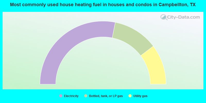
- 56.2%Electricity
- 23.1%Bottled, tank, or LP gas
- 20.6%Utility gas
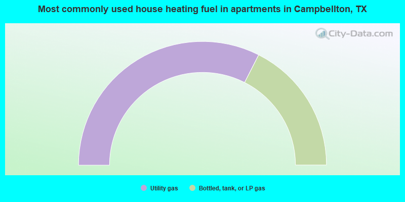
- 65.0%Utility gas
- 35.0%Bottled, tank, or LP gas
Campbellton compared to Texas state average:
- Median household income below state average.
- Median house value significantly below state average.
- Unemployed percentage significantly below state average.
- Black race population percentage significantly below state average.
- Median age above state average.
- Foreign-born population percentage significantly below state average.
- Length of stay since moving in significantly above state average.
- Number of rooms per house significantly below state average.
- House age significantly below state average.
- Number of college students significantly below state average.