Luthersville, Georgia
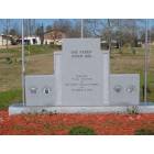
Luthersville: Luthersville Veterans Memorial
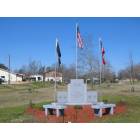
Luthersville: Luthersville Veteran's Memorial
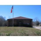
Luthersville: Luthersville US Post Office
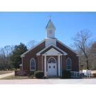
Luthersville: Luthersville United Methodist Church

Luthersville: Red Door Antiques
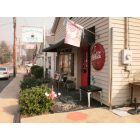
Luthersville: Red Door Antiques
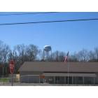
Luthersville: Luthersville Water Tower
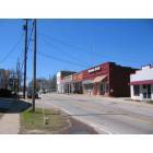
Luthersville: Downtown Luthersville
- add
your
Submit your own pictures of this city and show them to the world
(8.3% for White Non-Hispanic residents, 26.8% for Black residents, 4.5% for two or more races residents)
Detailed information about poverty and poor residents in Luthersville, GA
Full-time law enforcement employees in 2009, including police officers: 3 (3 officers - 3 male; 0 female).
| Officers per 1,000 residents here: | 3.64 |
| Georgia average: | 2.73 |
 Recent articles from our blog. Our writers, many of them Ph.D. graduates or candidates, create easy-to-read articles on a wide variety of topics.
| Here: | 3.1% |
| Georgia: | 2.9% |
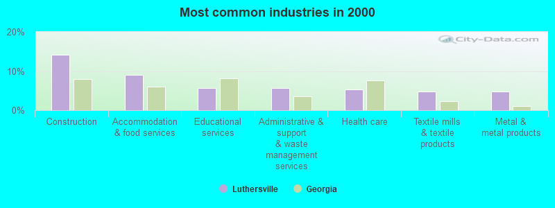
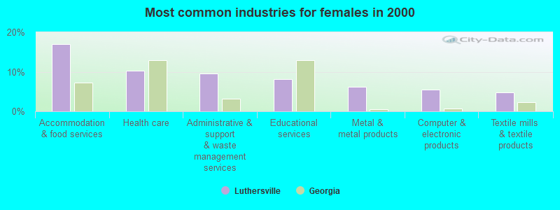
- Construction (14.1%)
- Accommodation & food services (9.1%)
- Educational services (5.7%)
- Administrative & support & waste management services (5.7%)
- Health care (5.4%)
- Textile mills & textile products (4.7%)
- Metal & metal products (4.7%)
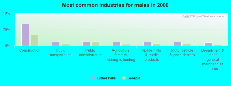
- Construction (26.5%)
- Truck transportation (5.3%)
- Public administration (5.3%)
- Agriculture, forestry, fishing & hunting (4.6%)
- Textile mills & textile products (4.6%)
- Motor vehicle & parts dealers (4.6%)
- Department & other general merchandise stores (4.0%)
- Accommodation & food services (17.0%)
- Health care (10.2%)
- Administrative & support & waste management services (9.5%)
- Educational services (8.2%)
- Metal & metal products (6.1%)
- Computer & electronic products (5.4%)
- Textile mills & textile products (4.8%)
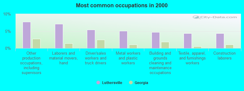
- Other production occupations, including supervisors (7.7%)
- Laborers and material movers, hand (7.0%)
- Driver/sales workers and truck drivers (5.4%)
- Metal workers and plastic workers (5.0%)
- Building and grounds cleaning and maintenance occupations (4.7%)
- Textile, apparel, and furnishings workers (4.4%)
- Construction laborers (4.4%)
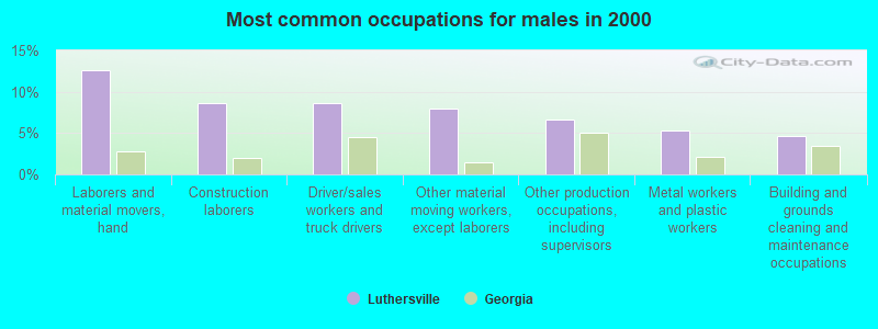
- Laborers and material movers, hand (12.6%)
- Construction laborers (8.6%)
- Driver/sales workers and truck drivers (8.6%)
- Other material moving workers, except laborers (7.9%)
- Other production occupations, including supervisors (6.6%)
- Metal workers and plastic workers (5.3%)
- Building and grounds cleaning and maintenance occupations (4.6%)
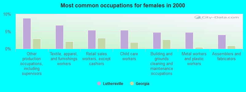
- Other production occupations, including supervisors (8.8%)
- Textile, apparel, and furnishings workers (6.8%)
- Retail sales workers, except cashiers (5.4%)
- Child care workers (5.4%)
- Building and grounds cleaning and maintenance occupations (4.8%)
- Metal workers and plastic workers (4.8%)
- Assemblers and fabricators (4.1%)
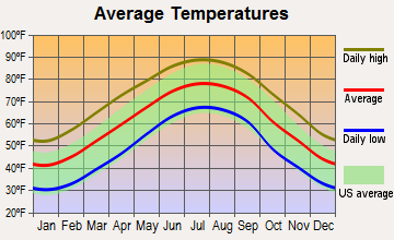
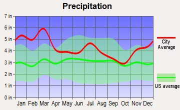
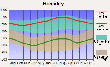
Average climate in Luthersville, Georgia
Based on data reported by over 4,000 weather stations
(lower is better)
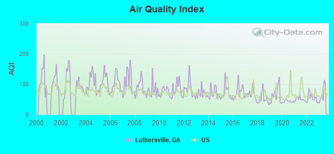
Air Quality Index (AQI) level in 2023 was 67.5. This is about average.
| City: | 67.5 |
| U.S.: | 72.6 |

Ozone [ppb] level in 2023 was 35.7. This is about average. Closest monitor was 13.5 miles away from the city center.
| City: | 35.7 |
| U.S.: | 33.3 |
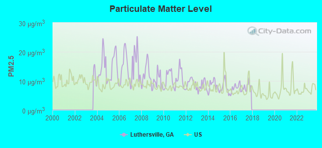
Particulate Matter (PM2.5) [µg/m3] level in 2017 was 7.90. This is about average. There were 0 monitors within city limits.
| City: | 7.90 |
| U.S.: | 8.11 |
Tornado activity:
Luthersville-area historical tornado activity is slightly above Georgia state average. It is 54% greater than the overall U.S. average.
On 3/5/1989, a category F3 (max. wind speeds 158-206 mph) tornado 6.9 miles away from the Luthersville city center injured 23 people and caused between $5,000,000 and $50,000,000 in damages.
On 4/2/1970, a category F3 tornado 8.9 miles away from the city center caused between $5000 and $50,000 in damages.
Earthquake activity:
Luthersville-area historical earthquake activity is significantly above Georgia state average. It is 48% greater than the overall U.S. average.On 4/29/2003 at 08:59:39, a magnitude 4.9 (4.4 MB, 4.6 MW, 4.9 LG, Class: Light, Intensity: IV - V) earthquake occurred 102.3 miles away from Luthersville center
On 8/2/1974 at 08:52:09, a magnitude 4.9 (4.3 MB, 4.9 LG) earthquake occurred 138.0 miles away from Luthersville center
On 4/29/2003 at 08:59:39, a magnitude 4.6 (4.6 MW, Depth: 12.3 mi) earthquake occurred 102.3 miles away from Luthersville center
On 1/18/1999 at 07:00:53, a magnitude 4.8 (4.8 MB, 4.0 LG, Depth: 0.6 mi) earthquake occurred 145.7 miles away from Luthersville center
On 10/24/1997 at 08:35:17, a magnitude 4.9 (4.8 MB, 4.2 MS, 4.9 LG, Depth: 6.2 mi) earthquake occurred 206.6 miles away from Luthersville center
On 11/30/1973 at 07:48:41, a magnitude 4.7 (4.7 MB, 4.6 ML) earthquake occurred 184.6 miles away from Luthersville center
Magnitude types: regional Lg-wave magnitude (LG), body-wave magnitude (MB), local magnitude (ML), surface-wave magnitude (MS), moment magnitude (MW)
Natural disasters:
The number of natural disasters in Meriwether County (11) is smaller than the US average (15).Major Disasters (Presidential) Declared: 7
Emergencies Declared: 3
Causes of natural disasters: Floods: 4, Tornadoes: 4, Storms: 3, Heavy Rains: 2, Hurricanes: 2, Winds: 2, Winter Storms: 2, Drought: 1, Tropical Storm: 1, Other: 1 (Note: some incidents may be assigned to more than one category).
Hospitals and medical centers near Luthersville:
- PIEDMONT NEWNAN HOSPITAL, INC Acute Care Hospitals (about 11 miles away; NEWNAN, GA)
- NEWNAN HEALTH AND REHABILITATION (Nursing Home, about 12 miles away; NEWNAN, GA)
- CROSSPOINT HEALTH CARE, INC (Hospital, about 12 miles away; NEWNAN, GA)
- AVALON HEALTH AND REHABILITATION (Nursing Home, about 13 miles away; NEWNAN, GA)
- STARCREST OF NEWNAN (Nursing Home, about 13 miles away; NEWNAN, GA)
- GEORGIA BAPTIST HOSPICE (Hospital, about 13 miles away; NEWNAN, GA)
- DAVITA NEWNAN DIALYSIS (Dialysis Facility, about 13 miles away; NEWNAN, GA)
Airports located in Luthersville:
- Flying N Estates Airport (1GA2) (Runways: 1)
- Johnson Airport (74GA) (Runways: 1)
Colleges/universities with over 2000 students nearest to Luthersville:
- Southern Crescent Technical College (about 27 miles; Griffin, GA; Full-time enrollment: 4,168)
- University of West Georgia (about 33 miles; Carrollton, GA; FT enrollment: 10,358)
- Clayton State University (about 36 miles; Morrow, GA; FT enrollment: 5,844)
- Gordon State College (about 37 miles; Barnesville, GA; FT enrollment: 3,336)
- Atlanta Metropolitan State College (about 40 miles; Atlanta, GA; FT enrollment: 2,437)
- Atlanta Technical College (about 40 miles; Atlanta, GA; FT enrollment: 4,217)
- Spelman College (about 42 miles; Atlanta, GA; FT enrollment: 2,383)
Points of interest:
Notable location: Luthersville Fire Department (A). Display/hide its location on the map
Church in Luthersville: New Mount Bethel Church (A). Display/hide its location on the map
Birthplace of: Robert Ward (blues musician) - Blues and soul guitarist.
| This city: | 2.9 people |
| Georgia: | 2.6 people |
| This city: | 70.0% |
| Whole state: | 68.5% |
| This city: | 9.2% |
| Whole state: | 5.9% |
Likely homosexual households (counted as self-reported same-sex unmarried-partner households)
- Lesbian couples: 0.7% of all households
- Gay men: 0.7% of all households
Banks with branches in Luthersville (2011 data):
- Bank of Upson: Luthersville Branch at 24 North Main Street, branch established on 2002/11/12. Info updated 2010/03/22: Bank assets: $318.3 mil, Deposits: $283.8 mil, headquarters in Thomaston, GA, positive income, Commercial Lending Specialization, 7 total offices, Holding Company: Southcrest Financial Group, Inc.
| Here: | 9.2 |
| Georgia average: | 12.2 |
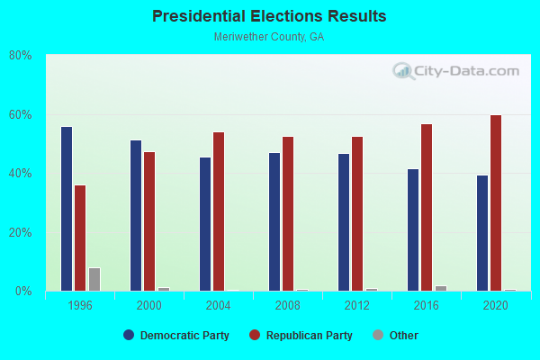
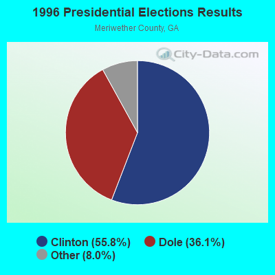
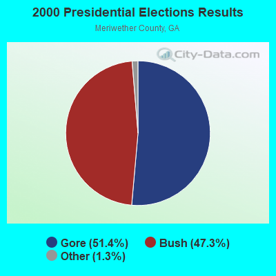
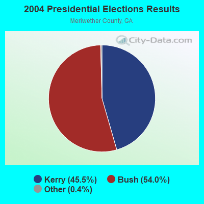
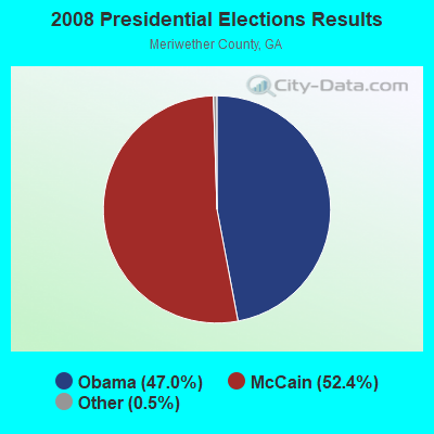
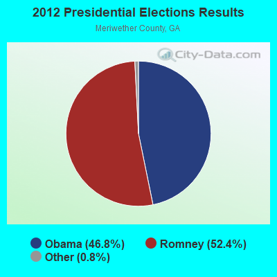
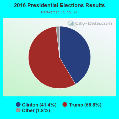
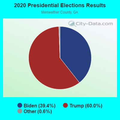
Graphs represent county-level data. Detailed 2008 Election Results
Religion statistics for Luthersville, GA (based on Meriwether County data)
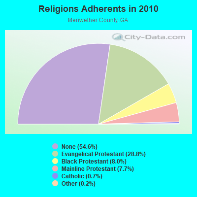
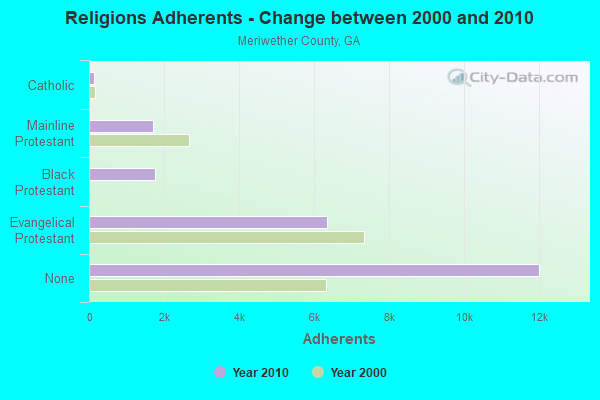
| Religion | Adherents | Congregations |
|---|---|---|
| Evangelical Protestant | 6,338 | 33 |
| Black Protestant | 1,760 | 8 |
| Mainline Protestant | 1,694 | 17 |
| Catholic | 145 | 1 |
| Other | 44 | 1 |
| None | 12,011 | - |
Food Environment Statistics:
| Here: | 3.52 / 10,000 pop. |
| Georgia: | 1.91 / 10,000 pop. |
| Here: | 1.32 / 10,000 pop. |
| Georgia: | 0.86 / 10,000 pop. |
| This county: | 7.48 / 10,000 pop. |
| Georgia: | 5.12 / 10,000 pop. |
| Here: | 7.04 / 10,000 pop. |
| State: | 7.41 / 10,000 pop. |
| Meriwether County: | 13.2% |
| Georgia: | 10.4% |
| This county: | 30.2% |
| Georgia: | 27.8% |
| Meriwether County: | 11.6% |
| Georgia: | 14.6% |
Health and Nutrition:
| Here: | 45.6% |
| State: | 48.9% |
| Luthersville: | 43.2% |
| State: | 46.5% |
| This city: | 31.0 |
| Georgia: | 28.9 |
| Luthersville: | 20.1% |
| Georgia: | 20.4% |
| Luthersville: | 14.1% |
| Georgia: | 10.8% |
| Luthersville: | 6.6 |
| Georgia: | 6.7 |
| Luthersville: | 36.9% |
| State: | 33.5% |
| Luthersville: | 52.6% |
| Georgia: | 56.2% |
| Here: | 84.8% |
| Georgia: | 80.8% |
More about Health and Nutrition of Luthersville, GA Residents
| Local government employment and payroll (March 2022) | |||||
| Function | Full-time employees | Monthly full-time payroll | Average yearly full-time wage | Part-time employees | Monthly part-time payroll |
|---|---|---|---|---|---|
| Financial Administration | 2 | $6,784 | $40,704 | 0 | $0 |
| Other Government Administration | 0 | $0 | 5 | $1,993 | |
| Totals for Government | 2 | $6,784 | $40,704 | 5 | $1,993 |
Luthersville government finances - Expenditure in 2017 (per resident):
- Current Operations - Financial Administration: $214,000 ($265.18)
Police Protection: $135,000 ($167.29)
Judicial and Legal Services: $87,000 ($107.81)
General Public Buildings: $44,000 ($54.52)
Regular Highways: $40,000 ($49.57)
Solid Waste Management: $37,000 ($45.85)
Libraries: $11,000 ($13.63)
Local Fire Protection: $9,000 ($11.15)
Parks and Recreation: $3,000 ($3.72)
General - Other: $1,000 ($1.24)
- General - Interest on Debt: $19,000 ($23.54)
Luthersville government finances - Revenue in 2017 (per resident):
- Charges - Sewerage: $93,000 ($115.24)
Solid Waste Management: $43,000 ($53.28)
Other: $21,000 ($26.02)
- Local Intergovernmental - General Local Government Support: $67,000 ($83.02)
- Miscellaneous - Fines and Forfeits: $41,000 ($50.81)
Rents: $4,000 ($4.96)
Donations From Private Sources: $2,000 ($2.48)
- Revenue - Water Utilities: $139,000 ($172.24)
- State Intergovernmental - Other: $10,000 ($12.39)
- Tax - Property: $143,000 ($177.20)
Alcoholic Beverage Sales: $62,000 ($76.83)
Insurance Premiums Sales: $57,000 ($70.63)
Public Utilities Sales: $44,000 ($54.52)
Occupation and Business License - Other: $16,000 ($19.83)
Other License: $1,000 ($1.24)
Luthersville government finances - Debt in 2017 (per resident):
- Long Term Debt - Beginning Outstanding - Unspecified Public Purpose: $468,000 ($579.93)
Outstanding Unspecified Public Purpose: $416,000 ($515.49)
Retired Unspecified Public Purpose: $52,000 ($64.44)
Luthersville government finances - Cash and Securities in 2017 (per resident):
- Other Funds - Cash and Securities: $236,000 ($292.44)
- Sinking Funds - Cash and Securities: $2,000 ($2.48)
Strongest AM radio stations in Luthersville:
- WGSE (720 AM; daytime; 8 kW; HOGANSVILLE, GA; Owner: CITICASTERS LICENSES, L.P.)
- WGST (640 AM; 50 kW; ATLANTA, GA; Owner: CITICASTERS LICENSES, L.P.)
- WGUN (1010 AM; 50 kW; ATLANTA, GA; Owner: WGUN, INC.)
- WSB (750 AM; 50 kW; ATLANTA, GA; Owner: CXR HOLDINGS, INC.)
- WMLB (1160 AM; 50 kW; EAST POINT, GA; Owner: ATLANTA AREA BROADCASTING, INC.)
- WAOK (1380 AM; 50 kW; ATLANTA, GA; Owner: INFINITY BROADCASTING OPERATIONS, INC.)
- WKNG (1060 AM; daytime; 50 kW; TALLAPOOSA, GA; Owner: WKNG, INC.)
- WCNN (680 AM; 50 kW; NORTH ATLANTA, GA; Owner: DICKEY BROADCASTING COMPANY)
- WQXI (790 AM; 28 kW; ATLANTA, GA; Owner: JEFFERSON-PILOT COMMUNICATIONS COMPANY OF GEORGIA)
- WFTD (1080 AM; daytime; 50 kW; MARIETTA, GA; Owner: PRIETO ENTERPRISES, INC.)
- WAZX (1550 AM; 50 kW; SMYRNA, GA; Owner: GA-MEX BROADCASTING, INC.)
- WMAC (940 AM; 50 kW; MACON, GA; Owner: CUMULUS LICENSING CORP.)
- WNSI (810 AM; 50 kW; JACKSONVILLE, AL; Owner: UNITED BROADCASTING NETWORK, INC.)
Strongest FM radio stations in Luthersville:
- WALR-FM (104.1 FM; LA GRANGE, GA; Owner: CXR HOLDINGS, INC.)
- WVFJ-FM (93.3 FM; MANCHESTER, GA; Owner: PROVIDENT BROADCASTING COMPANY)
- WJSP-FM (88.1 FM; WARM SPRINGS, GA; Owner: GEORGIA PUBLIC TELECOMMUNICATIONS COMMISSION)
- WBZY-FM (96.7 FM; PEACHTREE CITY, GA; Owner: CITICASTERS LICENSES, L.P.)
- WKZJ (95.7 FM; GREENVILLE, GA; Owner: DAVIS B/CASTING OF COLUMBUS, INC)
- WHTA (107.9 FM; HAMPTON, GA; Owner: RADIO ONE LICENSES, LLC)
- WPZE (97.5 FM; FAYETTEVILLE, GA; Owner: ROA LICENSES, LLC)
- WMAX-FM (105.3 FM; BOWDON, GA; Owner: CLEAR CHANNEL BROADCASTING LICENSES, INC.)
- WKEU-FM (88.9 FM; THE ROCK, GA; Owner: GEORGIA FOUNDATION OF PUBLIC BROADCASTING, INC.)
- WMGP (98.1 FM; HOGANSVILLE, GA; Owner: CITICASTERS LICENSES, L.P.)
- WWWQ (100.5 FM; ANNISTON, AL; Owner: WNNX LICO, INC.)
- WNNX (99.7 FM; ATLANTA, GA; Owner: WNNX LICO, INC.)
- WBTR-FM (92.1 FM; CARROLLTON, GA; Owner: WYAI, INC.)
- WRFG (89.3 FM; ATLANTA, GA; Owner: RADIO FREE GEORGIA BROADCASTING FOUNDATION INC)
- WSB-FM (98.5 FM; ATLANTA, GA; Owner: CXR HOLDINGS, INC.)
- WSTR (94.1 FM; SMYRNA, GA; Owner: JEFFERSON-PILOT COMMUNICATIONS COMPANY OF GEORGIA)
- WVEE (103.3 FM; ATLANTA, GA; Owner: INFINITY BROADCASTING OPERATIONS, INC.)
- WZGC (92.9 FM; ATLANTA, GA; Owner: INFINITY BROADCASTING CORP. OF ATLANTA)
- W220AN (91.9 FM; LA GRANGE, ETC., GA; Owner: FAMILY STATIONS, INC.)
- WUWG (90.7 FM; CARROLLTON, GA; Owner: WEST GEORGIA COLLEGE)
TV broadcast stations around Luthersville:
- W04DB (Channel 4; ATLANTA, GA; Owner: VVILPTV, INC.)
- WJSP-TV (Channel 28; COLUMBUS, GA; Owner: GEORGIA PUBLIC TELECOMMUNICATIONS COMMISSION)
- WUVG (Channel 34; ATHENS, GA; Owner: UNIVISION ATLANTA LLC)
- WAGA (Channel 5; ATLANTA, GA; Owner: FOX TELEVISION STATIONS, INC.)
- WSB-TV (Channel 2; ATLANTA, GA; Owner: WSB-TV HOLDINGS, INC.)
- WXIA-TV (Channel 11; ATLANTA, GA; Owner: GANNETT GEORGIA, L.P.)
- WSWS-TV (Channel 66; OPELIKA, AL; Owner: PAPPAS TELECASTING OF OPELIKA)
- WHSG (Channel 63; MONROE, GA; Owner: TRINITY BROADCASTING NETWORK)
- WUPA (Channel 69; ATLANTA, GA; Owner: VIACOM STATIONS GROUP OF ATLANTA INC.)
- WATL (Channel 36; ATLANTA, GA; Owner: WATL, LLC)
- WTBS (Channel 17; ATLANTA, GA; Owner: SUPERSTATION, INC.)
- WGCL-TV (Channel 46; ATLANTA, GA; Owner: MEREDITH CORPORATION)
- WANN-LP (Channel 32; ATLANTA, GA; Owner: PRISM BROADCASTING NETWORK, INC.)
- WDTA-LP (Channel 53; FAYETTEVILLE, GA; Owner: WORD OF GOD FELLOWSHIP, INC.)
- WPBA (Channel 30; ATLANTA, GA; Owner: BOARD OF EDUCATION OF THE CITY OF ATLANTA)
- WCAG-LP (Channel 33; LA GRANGE, GA; Owner: GEORGIA-ALABAMA BROADCASTING, INC.)
Luthersville fatal accident list:
Aug 1, 1999 06:55 PM, Sr-54, Lat: 33.205874, Lon: -84.760628, Vehicles: 1, Persons: 2, Fatalities: 1
May 5, 1991 11:41 AM, Sr41, Vehicles: 1, Persons: 2, Pedestrians: 1, Fatalities: 1
Aug 16, 1988 08:30 AM, Sr41, Vehicles: 2, Persons: 2, Fatalities: 1
Apr 24, 1978 11:49 AM, Vehicles: 2, Persons: 3, Fatalities: 1, Drunk persons involved: 1
- National Bridge Inventory (NBI) Statistics
- 7Number of bridges
- 30ft / 9.2mTotal length
- $1,679,000Total costs
- 6,230Total average daily traffic
- 59Total average daily truck traffic
- 9,345Total future (year 2031) average daily traffic
FCC Registered Antenna Towers:
15 (See the full list of FCC Registered Antenna Towers in Luthersville)FCC Registered Private Land Mobile Towers:
2- 23 Calvin Murphy Rd (Lat: 33.208167 Lon: -84.759944), Type: Tower, Structure height: 140 m, Call Sign: WPKN607,
Assigned Frequencies: 859.287 MHz, 859.312 MHz, 859.337 MHz, 859.362 MHz, 859.837 MHz, 860.287 MHz, 860.312 MHz, 860.337 MHz, 860.362 MHz, 860.787 MHz, 860.812 MHz, Grant Date: 07/30/2019, Expiration Date: 06/08/2029, Registrant: Southern Communications Services, Inc D/B/A Southern Linc, 600 18th St N Bin Sn-0800, Birmingham, AL 35203-2206, Phone: (205) 257-1534, Email:
- 23 Calvin Murphy Rd (Lat: 33.208167 Lon: -84.759944), Type: Tower, Structure height: 140 m, Call Sign: WQJM878,
Assigned Frequencies: 855.087 MHz, Grant Date: 04/28/2009, Expiration Date: 06/08/2019, Cancellation Date: 06/28/2012, Certifier: Robin J Cohen, Registrant: Sprint Nextel Corporation, 12502 Sunrise Valley Drive, M/S: Varesa0209, Reston, VA 20196, Phone: (703) 433-4000, Fax: (703) 433-4483
FCC Registered Broadcast Land Mobile Towers:
5- City Hall (Lat: 33.210389 Lon: -84.744667), Call Sign: KMK584,
Assigned Frequencies: 155.430 MHz, Grant Date: 11/08/2012, Expiration Date: 01/11/2023, Cancellation Date: 03/18/2023, Registrant: Business Radio Licensing, 30251 Golden Lantern Suite E #501, Laguna Niguel, CA 92677, Phone: (949) 348-8510, Fax: (949) 348-8514, Email:
- City Hall (Lat: 33.210389 Lon: -84.744667), Type: Building, Structure height: 30 m, Call Sign: WPNT924,
Assigned Frequencies: 460.125 MHz, Grant Date: 07/23/2014, Expiration Date: 06/16/2024, Certifier: Joel G Glazier, Registrant: Lone Peak Licensing, LLC, Draper, UT 84020-1336, Phone: (801) 938-9346, Fax: (801) 938-9465, Email:
- Ga Hwy 54 2.1 Mi W Of Ga 27 (Lat: 33.209278 Lon: -84.759944), Call Sign: KKQ573,
Assigned Frequencies: 451.425 MHz, Grant Date: 08/19/1997, Expiration Date: 08/19/2002, Cancellation Date: 06/14/2002, Registrant: Mcdermott, Will & Emery, 600 13th Street, Nw, Washington, DC 20005-3096, Phone: (202) 756-8281, Fax: (202) 756-8087, Email:
- Hwy 54 2.1 Mi W Hwy 27 (Lat: 33.209278 Lon: -84.759944), Call Sign: KKQ578,
Assigned Frequencies: 451.425 MHz, 451.425 MHz, 451.575 MHz, 451.575 MHz, Grant Date: 08/18/1997, Expiration Date: 08/18/2002, Cancellation Date: 06/14/2002, Registrant: Mcdermott, Will & Emery, 600 13th Street, Nw, Washington, DC 20005-3096, Phone: (202) 756-8281, Fax: (202) 756-8087, Email:
- MOBILES around Loc-1, Lat: 33.204722 Lon: -84.745000, Call Sign: KFU480,
Assigned Frequencies: 160.830 MHz, 160.950 MHz, Grant Date: 04/13/2012, Expiration Date: 07/01/2022, Cancellation Date: 08/28/2020, Registrant: Central Of Georgia Railway Company, 1200 Peachtree Street Ne, Atlanta, GA 30309, Phone: (404) 582-6224, Email:
FCC Registered Microwave Towers:
4- STATION, N Side Of Hwy 54 2 Mi W Of Jct Of Hwys 54 & 27 (Lat: 33.208167 Lon: -84.759917), Overall height: 67.7 m, Call Sign: WNTV862,
Assigned Frequencies: 952.431 MHz, 928.431 MHz, Grant Date: 06/09/2009, Expiration Date: 08/09/2019, Cancellation Date: 07/03/2019, Registrant: Southern Company Services, 600 North 18th St/Bin 5n-8409, Birmingham, AL 35203, Phone: (205) 257-3223, Fax: (202) 223-0833, Email:
- LUTHERSVILLE, 23 Calvin Murphy Road (Lat: 33.208056 Lon: -84.760000), Type: Gtower, Structure height: 140.2 m, Overall height: 146.3 m, Call Sign: WQWN520,
Assigned Frequencies: 11385.0 MHz, 11425.0 MHz, 6123.10 MHz, 6152.75 MHz, 11385.0 MHz, 11425.0 MHz, 6123.10 MHz, 6152.75 MHz, 11385.0 MHz, 11425.0 MHz... (+22 more), Grant Date: 10/13/2015, Expiration Date: 10/13/2025, Certifier: Larry F Butts, Registrant: Southern Company Services, 600 N. 18th St / Bin 5n-5409, Birmingham, AL 35203, Phone: (205) 257-7600, Fax: (205) 257-2134, Email:
- Luthersville, 33 Railroad St (Lat: 33.204750 Lon: -84.745000), Type: Ltower, Structure height: 61 m, Overall height: 62.2 m, Call Sign: KRA25,
Assigned Frequencies: 6315.84 MHz, 6375.14 MHz, Grant Date: 06/29/2021, Expiration Date: 09/10/2031, Registrant: Norfolk Southern, 650 West Peachtree St Nw, Atlanta, GA 30308, Phone: (404) 582-6244, Email:
- STATION, N Side Of Hwy 54 2 Mi W Of Jct Hwy 54 & 27 (Lat: 33.208167 Lon: -84.759917), Overall height: 67.7 m, Call Sign: WDX86,
Assigned Frequencies: 2184.00 MHz, 1975.00 MHz, 1935.00 MHz, 6595.00 MHz, Grant Date: 05/04/1993, Expiration Date: 05/04/1998, Cancellation Date: 06/16/1997, Phone: (404) 526-3808
FCC Registered Amateur Radio Licenses:
9 (See the full list of FCC Registered Amateur Radio Licenses in Luthersville)FAA Registered Aircraft:
42 (See the full list of FAA Registered Aircraft in Luthersville)| Most common first names in Luthersville, GA among deceased individuals | ||
| Name | Count | Lived (average) |
|---|---|---|
| William | 18 | 69.8 years |
| James | 18 | 61.6 years |
| John | 14 | 72.9 years |
| Mary | 13 | 76.2 years |
| Robert | 13 | 68.8 years |
| Annie | 11 | 79.4 years |
| Willie | 8 | 69.5 years |
| Henry | 8 | 68.9 years |
| Charles | 6 | 65.0 years |
| Albert | 5 | 82.6 years |
| Most common last names in Luthersville, GA among deceased individuals | ||
| Last name | Count | Lived (average) |
|---|---|---|
| Rowe | 11 | 74.7 years |
| Murphy | 9 | 75.1 years |
| Martin | 9 | 75.8 years |
| Phillips | 9 | 70.5 years |
| Hill | 8 | 74.9 years |
| Brown | 8 | 69.6 years |
| Hurst | 7 | 81.6 years |
| Parks | 6 | 70.2 years |
| Davis | 6 | 67.5 years |
| Godfrey | 6 | 74.0 years |
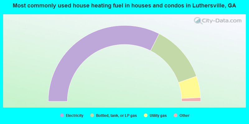
- 66.1%Electricity
- 24.6%Bottled, tank, or LP gas
- 9.3%Utility gas
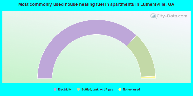
- 73.7%Electricity
- 25.1%Bottled, tank, or LP gas
- 1.2%No fuel used
Luthersville compared to Georgia state average:
- Median house value below state average.
- Unemployed percentage below state average.
- Black race population percentage above state average.
- Hispanic race population percentage significantly below state average.
- Median age significantly below state average.
- Foreign-born population percentage significantly below state average.
- Length of stay since moving in above state average.
- House age above state average.
- Number of college students below state average.
- Percentage of population with a bachelor's degree or higher significantly below state average.

|
Total of 6 patent applications in 2008-2024.