Oakland, Alabama
Submit your own pictures of this place and show them to the world
- OSM Map
- General Map
- Google Map
- MSN Map

| Males: 2,023 | |
| Females: 2,092 |
| Median resident age: | 39.4 years |
| Alabama median age: | 35.8 years |
Zip code: 35633
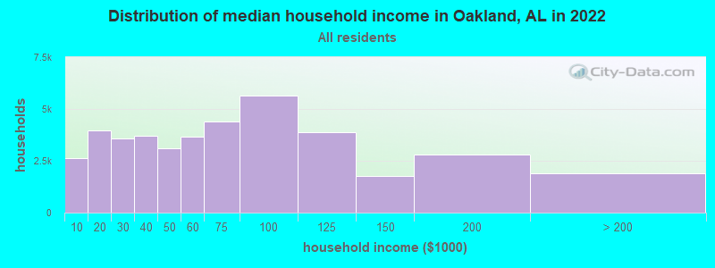
| Oakland: | $62,584 |
| AL: | $59,674 |
Estimated per capita income in 2022: $30,257 (it was $17,094 in 2000)
Oakland CCD income, earnings, and wages data
Estimated median house or condo value in 2022: $197,145 (it was $84,700 in 2000)
| Oakland: | $197,145 |
| AL: | $200,900 |
Detailed information about poverty and poor residents in Oakland, AL


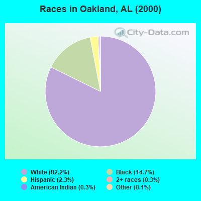
- 3,36182.2%White alone
- 60114.7%Black alone
- 942.3%Hispanic
- 110.3%American Indian alone
- 140.3%Two or more races
- 60.1%Other race alone
- 20.05%Asian alone
- 10.02%Native Hawaiian and Other
Pacific Islander alone
 Recent articles from our blog. Our writers, many of them Ph.D. graduates or candidates, create easy-to-read articles on a wide variety of topics.
Current Local Time: CST time zone
Land area: 97.4 square miles.
Population density: 42 people per square mile (very low).

| Oakland CCD: | 0.4% ($306) |
| Alabama: | 0.4% ($289) |
Nearest city with pop. 50,000+: Decatur, AL  (49.7 miles , pop. 53,929).
Nearest city with pop. 200,000+: Birmingham, AL (107.1 miles , pop. 242,820).
Nearest city with pop. 1,000,000+: Chicago, IL (484.2 miles , pop. 2,896,016).
Nearest cities:
), ), ), ), ), )Latitude: 34.84 N, Longitude: 87.80 W
Area code commonly used in this area: 256

| Here: | 2.7% |
| Alabama: | 2.6% |
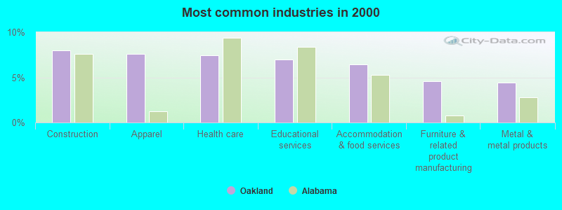
- Construction (8.0%)
- Apparel (7.6%)
- Health care (7.5%)
- Educational services (7.0%)
- Accommodation & food services (6.4%)
- Furniture & related product manufacturing (4.6%)
- Metal & metal products (4.4%)
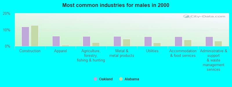
- Construction (11.8%)
- Apparel (6.1%)
- Agriculture, forestry, fishing & hunting (6.1%)
- Metal & metal products (6.1%)
- Utilities (5.9%)
- Accommodation & food services (5.8%)
- Administrative & support & waste management services (5.8%)
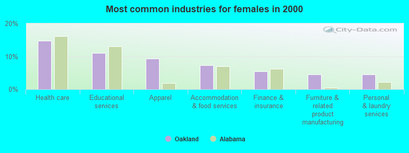
- Health care (14.7%)
- Educational services (11.0%)
- Apparel (9.3%)
- Accommodation & food services (7.2%)
- Finance & insurance (5.5%)
- Furniture & related product manufacturing (4.6%)
- Personal & laundry services (4.5%)
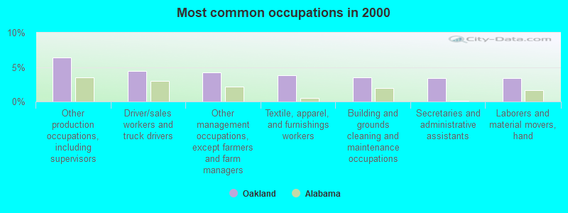
- Other production occupations, including supervisors (6.4%)
- Driver/sales workers and truck drivers (4.4%)
- Other management occupations, except farmers and farm managers (4.2%)
- Textile, apparel, and furnishings workers (3.9%)
- Building and grounds cleaning and maintenance occupations (3.5%)
- Secretaries and administrative assistants (3.4%)
- Laborers and material movers, hand (3.4%)
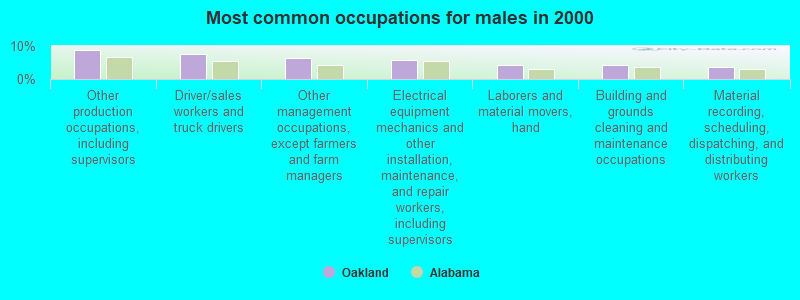
- Other production occupations, including supervisors (8.9%)
- Driver/sales workers and truck drivers (7.5%)
- Other management occupations, except farmers and farm managers (6.2%)
- Electrical equipment mechanics and other installation, maintenance, and repair workers, including supervisors (5.9%)
- Laborers and material movers, hand (4.4%)
- Building and grounds cleaning and maintenance occupations (4.3%)
- Material recording, scheduling, dispatching, and distributing workers (3.7%)
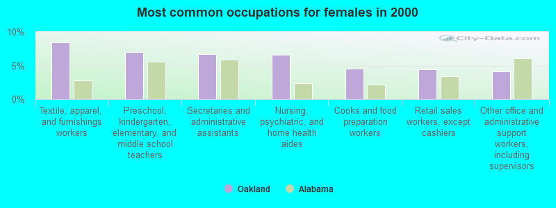
- Textile, apparel, and furnishings workers (8.5%)
- Preschool, kindergarten, elementary, and middle school teachers (7.0%)
- Secretaries and administrative assistants (6.7%)
- Nursing, psychiatric, and home health aides (6.6%)
- Cooks and food preparation workers (4.6%)
- Retail sales workers, except cashiers (4.5%)
- Other office and administrative support workers, including supervisors (4.1%)
Average climate in Oakland, Alabama
Based on data reported by over 4,000 weather stations


(lower is better)
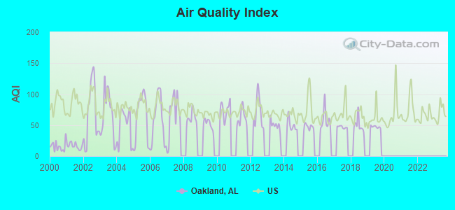
Air Quality Index (AQI) level in 2019 was 47.2. This is significantly better than average.
| City: | 47.2 |
| U.S.: | 72.6 |
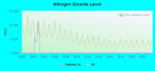
Nitrogen Dioxide (NO2) [ppb] level in 2002 was 5.86. This is about average. Closest monitor was 10.6 miles away from the city center.
| City: | 5.86 |
| U.S.: | 5.11 |
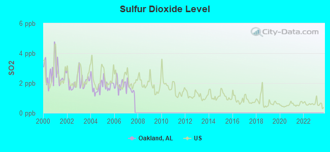
Sulfur Dioxide (SO2) [ppb] level in 2007 was 1.62. This is about average. Closest monitor was 3.9 miles away from the city center.
| City: | 1.62 |
| U.S.: | 1.51 |
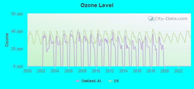
Ozone [ppb] level in 2019 was 24.8. This is better than average. Closest monitor was 10.5 miles away from the city center.
| City: | 24.8 |
| U.S.: | 33.3 |
Tornado activity:
Oakland-area historical tornado activity is near Alabama state average. It is 113% greater than the overall U.S. average.
On 4/16/1998, a category F5 (max. wind speeds 261-318 mph) tornado 29.0 miles away from the Oakland place center killed 3 people and injured 36 people and caused $13 million in damages.
On 4/3/1974, a category F5 tornado 31.4 miles away from the place center killed 28 people and injured 267 people.
Earthquake activity:
Oakland-area historical earthquake activity is significantly above Alabama state average. It is 229% greater than the overall U.S. average.On 1/18/1999 at 07:00:53, a magnitude 4.8 (4.8 MB, 4.0 LG, Depth: 0.6 mi, Class: Light, Intensity: IV - V) earthquake occurred 104.1 miles away from the city center
On 4/29/2003 at 08:59:39, a magnitude 4.9 (4.4 MB, 4.6 MW, 4.9 LG) earthquake occurred 125.7 miles away from Oakland center
On 3/25/1976 at 00:41:20, a magnitude 5.0 (4.9 MB, 5.0 LG, Class: Moderate, Intensity: VI - VII) earthquake occurred 153.1 miles away from the city center
On 5/4/1991 at 01:18:54, a magnitude 5.0 (4.4 MB, 4.6 LG, 5.0 LG, Depth: 3.1 mi) earthquake occurred 164.7 miles away from the city center
On 4/18/2008 at 09:36:59, a magnitude 5.4 (5.1 MB, 4.8 MS, 5.4 MW, 5.2 MW) earthquake occurred 249.8 miles away from Oakland center
On 6/24/1975 at 11:11:36, a magnitude 4.5 (4.5 MB) earthquake occurred 77.7 miles away from Oakland center
Magnitude types: regional Lg-wave magnitude (LG), body-wave magnitude (MB), surface-wave magnitude (MS), moment magnitude (MW)
Natural disasters:
The number of natural disasters in Lauderdale County (16) is near the US average (15).Major Disasters (Presidential) Declared: 10
Emergencies Declared: 5
Causes of natural disasters: Floods: 7, Storms: 7, Tornadoes: 5, Hurricanes: 4, Winds: 3, Freezes: 2, Winter Storms: 2, Drought: 1, Ice Storm: 1, Snowfall: 1, Other: 1 (Note: some incidents may be assigned to more than one category).
Hospitals and medical centers near Oakland:
- HOSPICE OF THE SHOALS, INC (Hospital, about 7 miles away; FLORENCE, AL)
- MITCHELL-HOLLINGSWORTH NURSING AND REHABILITATION (Nursing Home, about 7 miles away; FLORENCE, AL)
- ELIZA COFFEE MEMORIAL HOSPITAL Acute Care Hospitals (about 8 miles away; FLORENCE, AL)
- WIREGRASS HOSPICE, FLORENCE (Hospital, about 8 miles away; FLORENCE, AL)
- AMEDISYS HOME HEALTH OF FLORENCE (Home Health Center, about 8 miles away; FLORENCE, AL)
- FLORENCE DIALYSIS (Dialysis Facility, about 8 miles away; FLORENCE, AL)
- GOOD SAMARITAN HOSPICE, USA (Hospital, about 8 miles away; FLORENCE, AL)
Colleges/universities with over 2000 students nearest to Oakland:
- University of North Alabama (about 8 miles; Florence, AL; Full-time enrollment: 5,886)
- Northwest-Shoals Community College (about 10 miles; Muscle Shoals, AL; FT enrollment: 2,702)
- Northeast Mississippi Community College (about 46 miles; Booneville, MS; FT enrollment: 3,024)
- Athens State University (about 48 miles; Athens, AL; FT enrollment: 2,771)
- John C Calhoun State Community College (about 50 miles; Tanner, AL; FT enrollment: 7,911)
- Itawamba Community College (about 53 miles; Fulton, MS; FT enrollment: 5,489)
- University of Alabama in Huntsville (about 67 miles; Huntsville, AL; FT enrollment: 6,006)
Points of interest:
Notable locations in Oakland: Florence Golf and Country Club (A), Lauderdale County Farm (B), Oakland Fire Department (C). Display/hide their locations on the map
Churches in Oakland include: Rock Primitive Baptist Church (A), Riverbend Church of Christ (B), Pleasant Hill United Methodist Church (C), Oak Grove African Methodist Episcopal Church (D), New Hope Church of Christ (E), Mount Zion Primitive Baptist Church (F), Jerusalem Missionary Baptist Church (G), Canaan United Methodist Church (H), Rhodesville Church (I). Display/hide their locations on the map
Cemeteries: Simpson Cemetery (1), Cunningham Cemetery (2), Duncan Cemetery (3), Key Cemetery (4), Sherrod Cemetery (5), Pearson Cemetery (6), Anderson Cemetery (7). Display/hide their locations on the map
Lakes, reservoirs, and swamps: Winnie Pond (A), Darby Pond (B), Smith Pond (C), Perry Pond (D), Bell Sink Pond (E), Big Hill Pond (F), Delahunty Pond (G), Jackson Hill Pond (H). Display/hide their locations on the map
Streams, rivers, and creeks: Smith Ditch (A), Sinking Creek (B), McIntyre Ditch (C), Fowler Branch (D), Cave Spring Branch (E), Cypress Creek (F), Cox Creek (G), Coffee Slough (H), Bruton Branch (I). Display/hide their locations on the map
Parks in Oakland include: Seven Mile Island Public Shooting Area (1), Sevenmile Island Wildlife Management Area (2), Florence Municipal Park (3). Display/hide their locations on the map
| This place: | 2.4 people |
| Alabama: | 2.5 people |
| This place: | 73.0% |
| Whole state: | 67.8% |
| This place: | 2.8% |
| Whole state: | 4.7% |
Likely homosexual households (counted as self-reported same-sex unmarried-partner households)
- Lesbian couples: 0.3% of all households
- Gay men: 0.1% of all households
| This place: | 14.8% |
| Whole state: | 16.1% |
| This place: | 7.2% |
| Whole state: | 7.3% |
For population 15 years and over in Oakland:
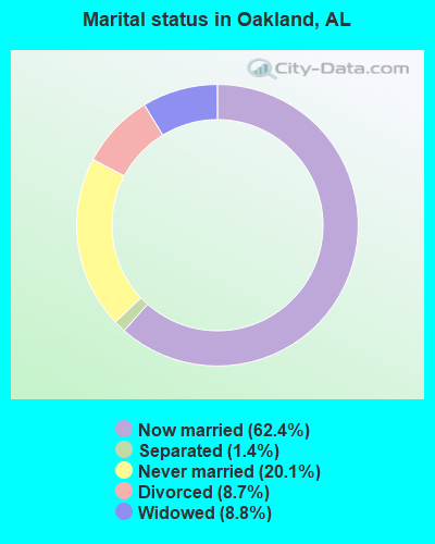
- Never married: 20.1%
- Now married: 62.4%
- Separated: 1.4%
- Widowed: 8.8%
- Divorced: 8.7%
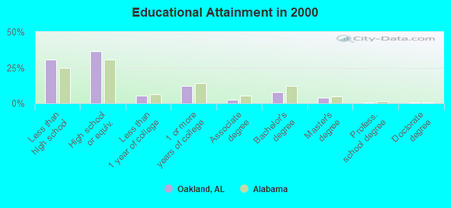
For population 25 years and over in Oakland:
- High school or higher: 69.2%
- Bachelor's degree or higher: 12.4%
- Graduate or professional degree: 4.9%
- Unemployed: 5.2%
- Mean travel time to work (commute): 23.1 minutes
| Here: | 13.6 |
| Alabama average: | 13.2 |
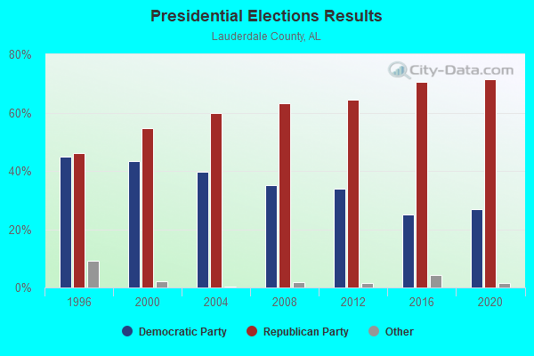
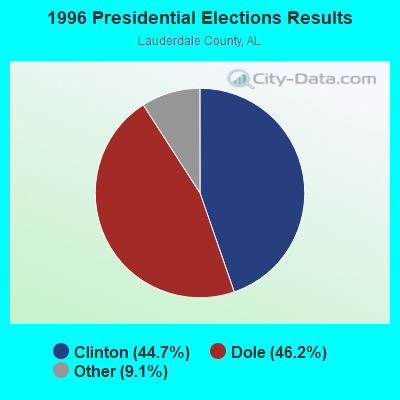
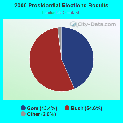
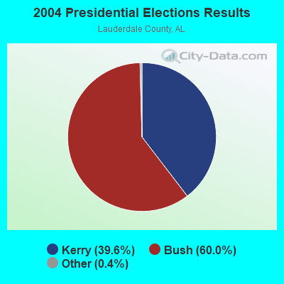
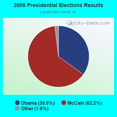
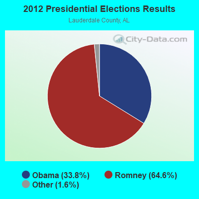
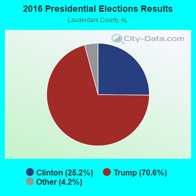
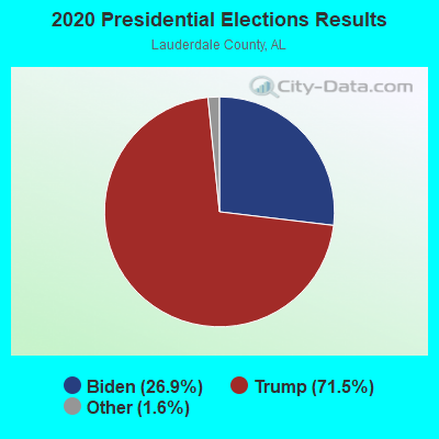
Graphs represent county-level data. Detailed 2008 Election Results
Religion statistics for Oakland, AL (based on Lauderdale County data)
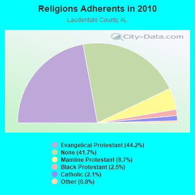
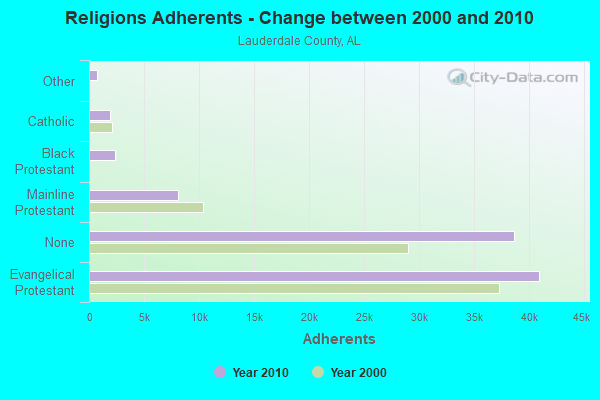
| Religion | Adherents | Congregations |
|---|---|---|
| Evangelical Protestant | 40,963 | 144 |
| Mainline Protestant | 8,079 | 38 |
| Black Protestant | 2,346 | 19 |
| Catholic | 1,948 | 2 |
| Other | 727 | 3 |
| None | 38,646 | - |
Food Environment Statistics:
| Lauderdale County: | 1.58 / 10,000 pop. |
| Alabama: | 1.89 / 10,000 pop. |
| Lauderdale County: | 0.23 / 10,000 pop. |
| Alabama: | 0.20 / 10,000 pop. |
| This county: | 1.24 / 10,000 pop. |
| State: | 0.65 / 10,000 pop. |
| Lauderdale County: | 5.65 / 10,000 pop. |
| State: | 6.32 / 10,000 pop. |
| Here: | 7.01 / 10,000 pop. |
| Alabama: | 5.75 / 10,000 pop. |
| This county: | 11.9% |
| Alabama: | 11.8% |
| Lauderdale County: | 30.1% |
| State: | 31.7% |
| This county: | 15.1% |
| State: | 13.5% |
Strongest AM radio stations in Oakland:
- WVNA (1590 AM; 5 kW; TUSCUMBIA, AL; Owner: CLEAR CHANNEL BROADCASTING LICENSES, INC.)
- WBCF (1240 AM; 1 kW; FLORENCE, AL; Owner: BENNY CARLE BROADCASTING, INC.)
- WSBM (1340 AM; 1 kW; FLORENCE, AL; Owner: BIG RIVER B/CING. CORP.)
- WZNN (620 AM; 5 kW; LEXINGTON, AL; Owner: MANUEL HUERTA)
- WBTG (1290 AM; 1 kW; SHEFFIELD, AL)
- WLAY (1450 AM; 1 kW; MUSCLE SHOALS, AL; Owner: CLEAR CHANNEL BROADCASTING LICENSES, INC.)
- WLOR (1550 AM; 50 kW; HUNTSVILLE, AL; Owner: BCA RADIO, LLC)
- WSM (650 AM; 50 kW; NASHVILLE, TN; Owner: GAYLORD ENTERTAINMENT COMPANY)
- WCPC (940 AM; 50 kW; HOUSTON, MS; Owner: WCPC BROADCASTING CO., INC.)
- WJOX (690 AM; 50 kW; BIRMINGHAM, AL; Owner: CITADEL BROADCASTING COMPANY)
- WDJC (850 AM; 50 kW; BIRMINGHAM, AL; Owner: KIMTRON, INC.)
- WCRV (640 AM; 50 kW; COLLIERVILLE, TN; Owner: BOTT BROADCASTING COMPANY/TENNESSEE)
- WVNN (770 AM; 10 kW; ATHENS, AL; Owner: ATHENS BROADCASTING COMPANY, INC.)
Strongest FM radio stations in Oakland:
- WLAY-FM (100.3 FM; TUSCUMBIA, AL; Owner: CLEAR CHANNEL BROADCASTING LICENSES, INC.)
- WQLT-FM (107.3 FM; FLORENCE, AL; Owner: BIG RIVER BROADCASTING CORPORATION)
- WFIX (91.3 FM; FLORENCE, AL; Owner: TRI-STATE INSPIRATIONAL B/C CORP.)
- WXFL (96.1 FM; FLORENCE, AL; Owner: BIG RIVER BROADCASTING CORP.)
- WVNA-FM (105.5 FM; MUSCLE SHOALS, AL; Owner: CLEAR CHANNEL BROADCASTING LICENSES, INC.)
- WBTG-FM (106.3 FM; SHEFFIELD, AL; Owner: SLATTON & ASSOCS. BROADCASTERS, INC.)
- W254AA (98.7 FM; COLBERT HEIGHTS, AL; Owner: WILLIAM P. ROGERS)
- WMXV (103.5 FM; RUSSELLVILLE, AL; Owner: CLEAR CHANNEL BROADCASTING LICENSES, INC.)
- W258AE (99.5 FM; FLORENCE, AL; Owner: WAY-FM MEDIA GROUP, INC.)
- WMSR-FM (94.9 FM; COLLINWOOD, TN; Owner: OHIO BROADCAST ASSOCIATES)
- WAKD (89.9 FM; SHEFFIELD, AL; Owner: AMERICAN FAMILY ASSOCIATION)
- W274AA (102.7 FM; MUSCLE SHOALS, AL; Owner: WILLIAM P. ROGERS)
- WQPR (88.7 FM; MUSCLE SHOALS, AL; Owner: THE BD OF TRUSTEES UNIV. OF ALABAMA)
- W202BY (88.3 FM; KILLEN, AL; Owner: WAY-FM MEDIA GROUP, INC.)
- WYTK (93.9 FM; ROGERSVILLE, AL; Owner: SHOALS BROADCASTING CORPORATION)
- W280DA (103.9 FM; FLORENCE, AL; Owner: BIBLE BROADCASTING NETWORK, INC.)
- WJOR-FM (101.5 FM; ST. JOSEPH, TN; Owner: CLEAR CHANNEL BROADCASTING LICENSES, INC.)
- WDNX (89.1 FM; OLIVE HILL, TN; Owner: RURAL LIFE FOUNDATION, INC)
- WOWL (91.9 FM; BURNSVILLE, MS; Owner: SOUTHERN COMMUNITY SERVICES, INC)
- WFXO (104.9 FM; IUKA, MS; Owner: BILLY R. MCLAIN)
TV broadcast stations around Oakland:
- WHDF (Channel 15; FLORENCE, AL; Owner: VALLEY TELEVISION, LLC)
- WBCF-LP (Channel 3; FLORENCE, AL; Owner: BENNY CARLE BROADCASTING, INC.)
- WXFL-LP (Channel 5; FLORENCE, ETC., AL; Owner: BENNY CARLE BROADCASTING, INC.)
- W57BV (Channel 57; FLORENCE, AL; Owner: TRINITY BROADCASTING NETWORK)
- WYLE (Channel 26; FLORENCE, AL; Owner: ETC COMMUNICATIONS INC.)
- WFIQ (Channel 36; FLORENCE, AL; Owner: ALABAMA EDUCATIONAL TELEVISION COMMISSION)
- W46CF (Channel 46; TUSCUMBIA, AL; Owner: UNITY BROADCASTING, INC.)
FCC Registered Broadcast Land Mobile Towers:
1- Harris N 0.35 M N Harris Rd & Rr (Lat: 34.663694 Lon: -86.970278), Type: Pole, Structure height: 14 m, Overall height: 17 m, Call Sign: WPPZ969, Licensee ID: L00258361,
Assigned Frequencies: 896.887 MHz, 896.937 MHz, 896.987 MHz, 897.887 MHz, 897.937 MHz, 897.987 MHz, Grant Date: 04/11/2000, Expiration Date: 04/11/2005, Cancellation Date: 02/10/2005, Certifier: Robert Vandeberg, Registrant: Association Of American Railroads Dba Transportation Technology Center Inc, 55500 Dot Rd, Pueblo, CO 81001, Phone: (719) 584-0578, Fax: (719) 584-7145
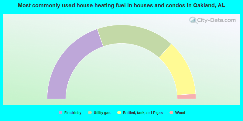
- 39.4%Electricity
- 34.0%Utility gas
- 24.4%Bottled, tank, or LP gas
- 2.2%Wood
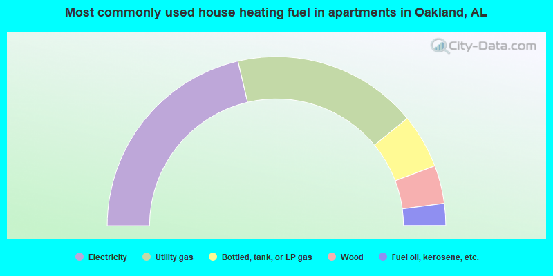
- 42.7%Electricity
- 35.4%Utility gas
- 10.4%Bottled, tank, or LP gas
- 7.3%Wood
- 4.2%Fuel oil, kerosene, etc.
Oakland compared to Alabama state average:
- Unemployed percentage below state average.
- Black race population percentage below state average.
- Hispanic race population percentage below state average.
- Foreign-born population percentage significantly below state average.
- Renting percentage below state average.
- Length of stay since moving in significantly above state average.
- Number of rooms per house significantly below state average.
- House age significantly below state average.
- Percentage of population with a bachelor's degree or higher below state average.