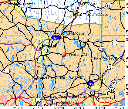
Preston, Connecticut
Preston

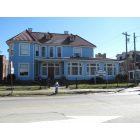
Preston: Old farm truck on route 164 in front of Roseledge Country Farm Shoppe

Preston: tunnels and root celler on our farm the old John Meech homestead
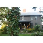
Preston: Historic John Meech House, Roseledge Herb Farm
- add
your
Submit your own pictures of this town and show them to the world
- OSM Map
- General Map
- Google Map
- MSN Map
Population change since 2000: +0.8%
 |
| Males: 2,355 | |
| Females: 2,371 |
| Median resident age: | 45.9 years |
| Connecticut median age: | 39.2 years |
Zip codes: 06360.
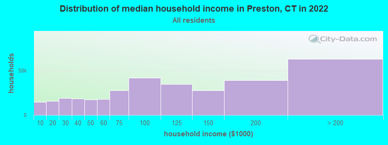
| Preston: | $90,080 |
| CT: | $88,429 |
Estimated per capita income in 2022: $44,383 (it was $24,752 in 2000)
Preston town income, earnings, and wages data
Estimated median house or condo value in 2022: $309,367 (it was $143,100 in 2000)
| Preston: | $309,367 |
| CT: | $347,200 |
Mean prices in 2022: all housing units: $336,024; detached houses: $358,368; townhouses or other attached units: $232,367; in 2-unit structures: $294,123; in 3-to-4-unit structures: $234,423; in 5-or-more-unit structures: $212,293; mobile homes: $38,564; occupied boats, rvs, vans, etc.: $86,722
Detailed information about poverty and poor residents in Preston, CT
Compare current foreclosures near Preston, CT:
| Photo | Address | Area | Beds / Baths | Price | Details |
|---|---|---|---|---|---|

|
#1
Shingle Point Rd
Preston, CT 06365
|
2,181 sq. feet
|
3 baths 4 beds |
show details | |

|
#2
Mathewson Mill Rd
Preston, CT 06365
|
3,240 sq. feet
|
2 baths 3 beds |
show details | |

|
#3
Route 2
Preston, CT 06365
|
936 sq. feet
|
1 baths 2 beds |
show details | |

|
#4
Prodell Rd
Preston, CT 06365
|
1,718 sq. feet
|
2 baths 3 beds |
show details | |

|
#5
Krug Rd
Preston, CT 06365
|
- sq. feet
|
- baths - beds |
show details | |

|
#6
Lake Dr E
Oakdale, CT 06370
|
1,346 sq. feet
|
1 baths 3 beds |
$365,000
|
show details |

|
#7
N Society Rd
Canterbury, CT 06331
|
768 sq. feet
|
1 baths 2 beds |
$269,900
|
show details |

|
#8
Rope Ferry Rd Unit N161
Waterford, CT 06385
|
576 sq. feet
|
1 baths 1 beds |
show details | |

|
#9
Tomaquag Rd
Ashaway, RI 02804
|
2,368 sq. feet
|
2 baths 4 beds |
show details | |

|
#10
Candlewood Rd
Groton, CT 06340
|
2,064 sq. feet
|
1 baths 3 beds |
show details |
| Photo | Address | Area | Beds / Baths | Price | Details |
|---|---|---|---|---|---|

|
#11
Hammond Ct
Colchester, CT 06415
|
1,152 sq. feet
|
1 baths 3 beds |
show details | |

|
#12
Vauxhall St
New London, CT 06320
|
915 sq. feet
|
1 baths 2 beds |
show details | |

|
#13
Liberty St
Pawcatuck, CT 06379
|
1,880 sq. feet
|
2 baths 4 beds |
show details | |

|
#14
Meeting House Ln
Ledyard, CT 06339
|
1,579 sq. feet
|
1 baths 4 beds |
show details | |

|
#15
Mary Hall Rd
Pawcatuck, CT 06379
|
1,064 sq. feet
|
1 baths 2 beds |
show details | |

|
#16
Cow Hill Rd
Mystic, CT 06355
|
1,614 sq. feet
|
2 baths 3 beds |
show details | |

|
#17
Boswell Ave
Norwich, CT 06360
|
1,768 sq. feet
|
2 baths 4 beds |
show details | |

|
#18
Boswell Ave
Norwich, CT 06360
|
2,244 sq. feet
|
4 baths 4 beds |
show details | |

|
#19
Broad St
Norwich, CT 06360
|
1,703 sq. feet
|
1 baths 4 beds |
show details | |

|
#20
Crestwood Dr
Hope Valley, RI 02832
|
1,320 sq. feet
|
2 baths 3 beds |
show details |
| Photo | Address | Area | Beds / Baths | Price | Details |
|---|---|---|---|---|---|

|
#21
Boswell Ave
Norwich, CT 06360
|
3,930 sq. feet
|
4 baths 8 beds |
show details | |

|
#22
Hemlock Rd
Groton, CT 06340
|
1,876 sq. feet
|
2 baths 3 beds |
show details | |

|
#23
Willetts Ave # 1
New London, CT 06320
|
3,571 sq. feet
|
3 baths 5 beds |
show details | |

|
#24
Summer St
New London, CT 06320
|
1,143 sq. feet
|
2 baths 3 beds |
show details | |

|
#25
Burgess Pl
Groton, CT 06340
|
1,082 sq. feet
|
1 baths 3 beds |
show details | |

|
#26
Brandegee Ave
Groton, CT 06340
|
560 sq. feet
|
1 baths 2 beds |
show details | |

|
#27
Elderkin Ave
Groton, CT 06340
|
672 sq. feet
|
1 baths 1 beds |
show details | |

|
#28
Allen St
Groton, CT 06340
|
952 sq. feet
|
1 baths 2 beds |
show details | |

|
#29
Clarks Falls Rd
North Stonington, CT 06359
|
1,638 sq. feet
|
2 baths 4 beds |
show details | |

|
#30
High St
Moosup, CT 06354
|
4,857 sq. feet
|
4 baths 4 beds |
show details |
| Photo | Address | Area | Beds / Baths | Price | Details |
|---|---|---|---|---|---|

|
#31
School St
Groton, CT 06340
|
1,050 sq. feet
|
1 baths 1 beds |
show details | |

|
#32
Alger Pl
New London, CT 06320
|
2,392 sq. feet
|
3 baths 4 beds |
show details | |

|
#33
Valley Rd
Groton, CT 06340
|
1,405 sq. feet
|
1 baths 3 beds |
show details | |

|
#34
Shady Grove Rd
Hope Valley, RI 02832
|
2,520 sq. feet
|
3 baths 4 beds |
show details | |

|
#35
Norwich Rd
Plainfield, CT 06374
|
2,161 sq. feet
|
1 baths 3 beds |
show details | |

|
#36
Bliven St
Groton, CT 06340
|
1,344 sq. feet
|
2 baths 3 beds |
show details | |

|
#37
Robinson Hill Rd
North Franklin, CT 06254
|
739 sq. feet
|
1 baths 2 beds |
show details | |

|
#38
Lake St
Moosup, CT 06354
|
1,092 sq. feet
|
1 baths 3 beds |
show details | |

|
#39
Beechwood Rd
Oakdale, CT 06370
|
1,008 sq. feet
|
1 baths 3 beds |
show details | |

|
#40
Reutemann Rd
North Stonington, CT 06359
|
1,296 sq. feet
|
1 baths 3 beds |
show details |
| Photo | Address | Area | Beds / Baths | Price | Details |
|---|---|---|---|---|---|

|
#41
Park Ave
Colchester, CT 06415
|
1,224 sq. feet
|
1 baths 3 beds |
show details | |

|
#42
Banjo Sullivan Rd
Jewett City, CT 06351
|
1,564 sq. feet
|
2 baths 4 beds |
show details | |

|
#43
Dow Rd
Plainfield, CT 06374
|
1,632 sq. feet
|
1 baths 3 beds |
show details | |

|
#44
Canal St
Westerly, RI 02891
|
878 sq. feet
|
1 baths 2 beds |
show details | |

|
#45
Highland View Dr
South Windham, CT 06266
|
1,056 sq. feet
|
1 baths 1 beds |
show details | |

|
#46
1st Ave
Waterford, CT 06385
|
1,547 sq. feet
|
1 baths 4 beds |
show details | |

|
#47
Ward Ave
Moosup, CT 06354
|
1,808 sq. feet
|
2 baths 3 beds |
show details | |

|
#48
Porter Pond Rd
Moosup, CT 06354
|
1,535 sq. feet
|
2 baths 1 beds |
show details | |

|
#49
Society Rd
Niantic, CT 06357
|
1,248 sq. feet
|
2 baths 4 beds |
show details | |

|
Check over 1 million property listings on Foreclosure.com!
|
browse all offers | |||

- 4,27490.4%White alone
- 1152.4%Hispanic
- 1042.2%Two or more races
- 1012.1%Asian alone
- 651.4%Black alone
- 551.2%American Indian alone
- 120.3%Other race alone
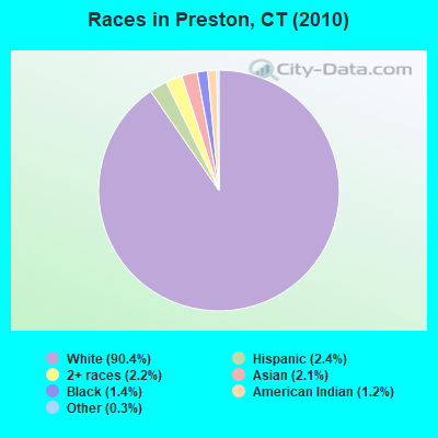
Races in Preston detailed stats: ancestries, foreign born residents, place of birth
According to our research of Connecticut and other state lists, there were 5 registered sex offenders living in Preston, Connecticut as of May 04, 2024.
The ratio of all residents to sex offenders in Preston is 945 to 1.
The ratio of registered sex offenders to all residents in this city is lower than the state average.
 Recent articles from our blog. Our writers, many of them Ph.D. graduates or candidates, create easy-to-read articles on a wide variety of topics.

 | 2024 Connecticut Town Tournament VI (Celebrating the 10-Year Anniversary & Dazzleman's Memorial) (771 replies) |
| Connecticut TOWN TOURNAMENT V (2022) (831 replies) |
| Connecticut TOWN TOURNAMENT IV (2020) (849 replies) |
| Where can I live my Martha Stewart life? Serious question! (34 replies) |
| Economic Climate in CT (18750 replies) |
| Connecticut TOWN TOURNAMENT III (2018) (385 replies) |
Latest news from Preston, CT collected exclusively by city-data.com from local newspapers, TV, and radio stations
Preston, CT City Guides:
Ancestries: Irish (18.9%), Polish (16.9%), English (15.3%), Italian (13.8%), German (13.5%), French (11.1%).
Current Local Time: EST time zone
Incorporated on 10/1687
Elevation: 190 feet
Land area: 30.9 square miles.
Population density: 153 people per square mile (very low).
164 residents are foreign born (1.5% Europe, 1.1% Asia, 0.5% Africa).
| This town: | 3.5% |
| Connecticut: | 10.9% |
| Preston town: | 1.3% ($1,847) |
| Connecticut: | 1.8% ($2,961) |
Nearest city with pop. 50,000+: Manchester, CT  (31.6 miles , pop. 54,740).
Nearest city with pop. 200,000+: Boston, MA (73.7 miles , pop. 589,141).
Nearest city with pop. 1,000,000+: Bronx, NY (106.7 miles , pop. 1,332,650).
Nearest cities:
), ), ), ), ), )Latitude: 41.51 N, Longitude: 72.03 W
Area code commonly used in this area: 860

Single-family new house construction building permits:
- 2022: 8 buildings, average cost: $305,900
- 2021: 12 buildings, average cost: $403,500
- 2020: 18 buildings, average cost: $314,200
- 2019: 11 buildings, average cost: $289,600
- 2018: 16 buildings, average cost: $319,600
- 2017: 8 buildings, average cost: $290,300
- 2016: 6 buildings, average cost: $302,600
- 2015: 11 buildings, average cost: $235,600
- 2013: 10 buildings, average cost: $229,300
- 2012: 8 buildings, average cost: $229,900
- 2011: 7 buildings, average cost: $226,100
- 2010: 7 buildings, average cost: $213,800
- 2009: 9 buildings, average cost: $213,800
- 2008: 2 buildings, average cost: $176,100
- 2007: 17 buildings, average cost: $217,000
- 2006: 18 buildings, average cost: $247,200
- 2005: 41 buildings, average cost: $260,600
- 2004: 32 buildings, average cost: $212,400
- 2003: 24 buildings, average cost: $142,300
- 2002: 21 buildings, average cost: $165,500
- 2001: 19 buildings, average cost: $143,700
- 2000: 19 buildings, average cost: $141,600
- 1999: 20 buildings, average cost: $105,500
- 1998: 19 buildings, average cost: $101,400
- 1997: 21 buildings, average cost: $90,400
| Here: | 3.6% |
| Connecticut: | 3.9% |
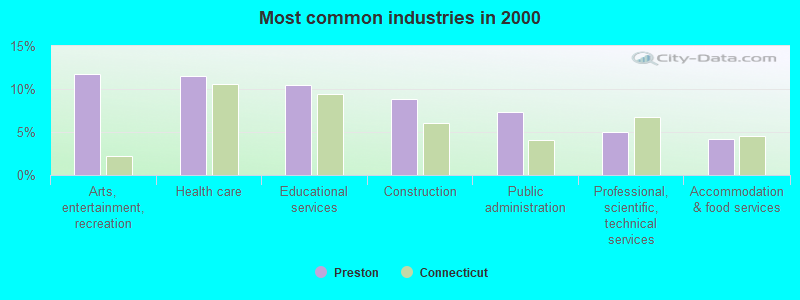
- Arts, entertainment, recreation (11.8%)
- Health care (11.5%)
- Educational services (10.5%)
- Construction (8.9%)
- Public administration (7.3%)
- Professional, scientific, technical services (5.0%)
- Accommodation & food services (4.2%)
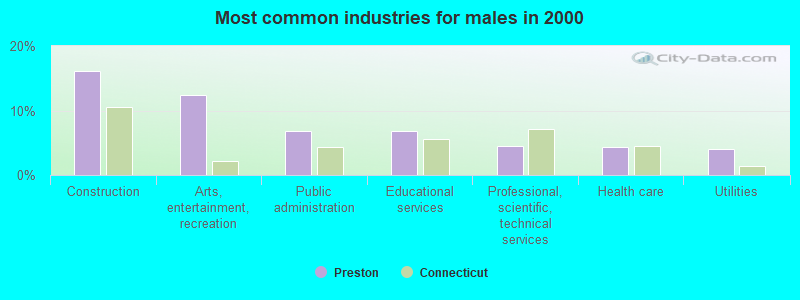
- Construction (16.1%)
- Arts, entertainment, recreation (12.4%)
- Public administration (6.8%)
- Educational services (6.8%)
- Professional, scientific, technical services (4.5%)
- Health care (4.3%)
- Utilities (4.0%)
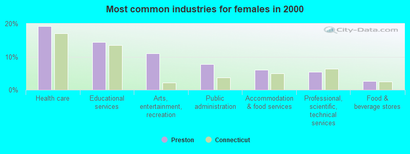
- Health care (19.2%)
- Educational services (14.4%)
- Arts, entertainment, recreation (11.0%)
- Public administration (7.8%)
- Accommodation & food services (6.1%)
- Professional, scientific, technical services (5.5%)
- Food & beverage stores (2.7%)
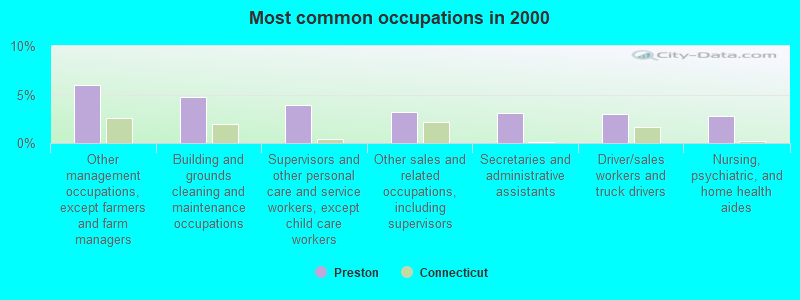
- Other management occupations, except farmers and farm managers (6.0%)
- Building and grounds cleaning and maintenance occupations (4.8%)
- Supervisors and other personal care and service workers, except child care workers (3.9%)
- Other sales and related occupations, including supervisors (3.2%)
- Secretaries and administrative assistants (3.1%)
- Driver/sales workers and truck drivers (3.0%)
- Nursing, psychiatric, and home health aides (2.8%)
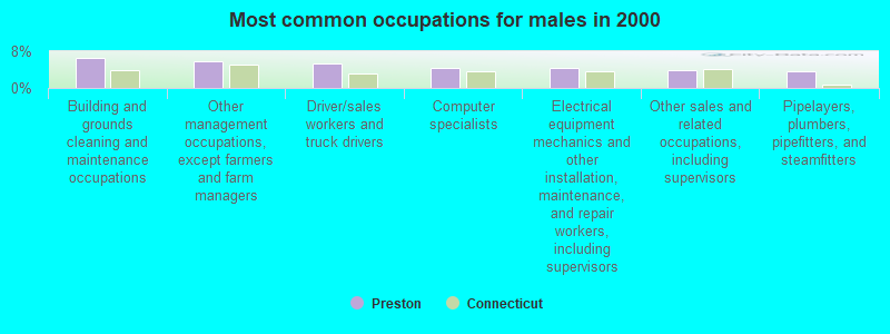
- Building and grounds cleaning and maintenance occupations (6.6%)
- Other management occupations, except farmers and farm managers (5.8%)
- Driver/sales workers and truck drivers (5.3%)
- Computer specialists (4.4%)
- Electrical equipment mechanics and other installation, maintenance, and repair workers, including supervisors (4.3%)
- Other sales and related occupations, including supervisors (3.9%)
- Pipelayers, plumbers, pipefitters, and steamfitters (3.6%)
- Secretaries and administrative assistants (6.5%)
- Other management occupations, except farmers and farm managers (6.2%)
- Preschool, kindergarten, elementary, and middle school teachers (4.9%)
- Supervisors and other personal care and service workers, except child care workers (4.7%)
- Other office and administrative support workers, including supervisors (4.6%)
- Nursing, psychiatric, and home health aides (4.3%)
- Registered nurses (3.9%)
Average climate in Preston, Connecticut
Based on data reported by over 4,000 weather stations


(lower is better)
Air Quality Index (AQI) level in 2023 was 90.3. This is worse than average.
| City: | 90.3 |
| U.S.: | 72.6 |
Nitrogen Dioxide (NO2) [ppb] level in 2017 was 1.35. This is significantly better than average. Closest monitor was 2.7 miles away from the city center.
| City: | 1.35 |
| U.S.: | 5.11 |
Ozone [ppb] level in 2023 was 34.5. This is about average. Closest monitor was 9.0 miles away from the city center.
| City: | 34.5 |
| U.S.: | 33.3 |
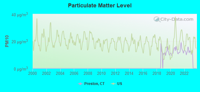
Particulate Matter (PM10) [µg/m3] level in 2022 was 12.6. This is significantly better than average. Closest monitor was 2.8 miles away from the city center.
| City: | 12.6 |
| U.S.: | 19.2 |
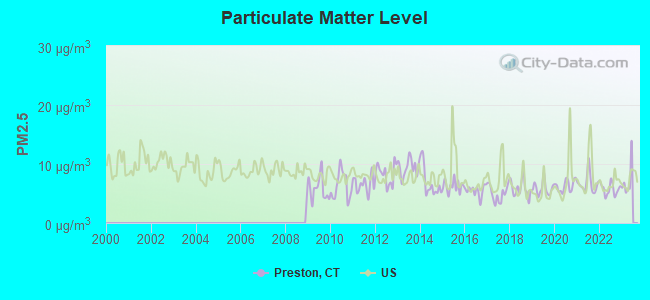
Particulate Matter (PM2.5) [µg/m3] level in 2022 was 5.76. This is significantly better than average. Closest monitor was 2.8 miles away from the city center.
| City: | 5.76 |
| U.S.: | 8.11 |
Tornado activity:
Preston-area historical tornado activity is slightly below Connecticut state average. It is 46% smaller than the overall U.S. average.
On 10/3/1979, a category F4 (max. wind speeds 207-260 mph) tornado 41.8 miles away from the Preston town center killed 3 people and injured 500 people and caused between $50,000,000 and $500,000,000 in damages.
On 8/21/1951, a category F3 (max. wind speeds 158-206 mph) tornado 25.0 miles away from the town center injured 8 people and caused between $50,000 and $500,000 in damages.
Earthquake activity:
Preston-area historical earthquake activity is significantly above Connecticut state average. It is 72% smaller than the overall U.S. average.On 10/7/1983 at 10:18:46, a magnitude 5.3 (5.1 MB, 5.3 LG, 5.1 ML, Class: Moderate, Intensity: VI - VII) earthquake occurred 205.6 miles away from Preston center
On 4/20/2002 at 10:50:47, a magnitude 5.3 (5.3 ML, Depth: 3.0 mi) earthquake occurred 223.9 miles away from the city center
On 4/20/2002 at 10:50:47, a magnitude 5.2 (5.2 MB, 4.2 MS, 5.2 MW, 5.0 MW) earthquake occurred 222.7 miles away from Preston center
On 1/19/1982 at 00:14:42, a magnitude 4.7 (4.5 MB, 4.7 MD, 4.5 LG, Class: Light, Intensity: IV - V) earthquake occurred 139.0 miles away from the city center
On 10/16/2012 at 23:12:25, a magnitude 4.7 (4.7 ML, Depth: 10.0 mi) earthquake occurred 160.0 miles away from the city center
On 8/22/1992 at 12:20:32, a magnitude 4.8 (4.8 MB, 3.8 MS, 4.7 LG, Depth: 6.2 mi) earthquake occurred 189.3 miles away from Preston center
Magnitude types: regional Lg-wave magnitude (LG), body-wave magnitude (MB), duration magnitude (MD), local magnitude (ML), surface-wave magnitude (MS), moment magnitude (MW)
Natural disasters:
The number of natural disasters in New London County (22) is greater than the US average (15).Major Disasters (Presidential) Declared: 12
Emergencies Declared: 10
Causes of natural disasters: Hurricanes: 6, Snowstorms: 5, Storms: 5, Floods: 4, Blizzards: 3, Winter Storms: 3, Snows: 2, Snowfall: 1, Tropical Storm: 1, Wind: 1 (Note: some incidents may be assigned to more than one category).

Hospitals and medical centers near Preston:
- HAMILTON PAVILION HEALTHCARE (Nursing Home, about 2 miles away; NORWICH, CT)
- REGENCY HEIGHTS OF NORWICH, LLC (Nursing Home, about 3 miles away; NORWICH, CT)
- UNCAS ON THAMES HOSPITAL (Hospital, about 4 miles away; NORWICH, CT)
- ELMACHRI REST HOME (Nursing Home, about 4 miles away; NORWICH, CT)
- HOSPICE OF SOUTHEASTERN CT INC (Home Health Center, about 4 miles away; NORWICH, CT)
- WILLIAM W BACKUS HOSPITAL Acute Care Hospitals (about 4 miles away; NORWICH, CT)
- UNITED COMM SVCS INC PHN DEPT-HOSPICE (Hospital, about 5 miles away; NORWICH, CT)
Amtrak stations near Preston:
- 5 miles: FOXWOOD CASINO (LEDYARD, ROUTE 2) - Bus Station
- 12 miles: NEW LONDON (27 WATER ST.) . Services: ticket office, partially wheelchair accessible, enclosed waiting area, public restrooms, public payphones, paid short-term parking, paid long-term parking, call for car rental service, taxi stand, intercity bus service, public transit connection.
- 12 miles: MYSTIC (RTE. 1) . Services: enclosed waiting area, public restrooms, public payphones, free short-term parking, call for car rental service, call for taxi service, public transit connection.
Operable nuclear power plants near Preston:
- 13 miles: Millstone 1 and 2 in Waterford, CT.
- 13 miles: Millstone 3 in Waterford, CT.
Colleges/universities with over 2000 students nearest to Preston:
- Three Rivers Community College (about 5 miles; Norwich, CT; Full-time enrollment: 2,897)
- Connecticut College (about 11 miles; New London, CT; FT enrollment: 2,068)
- Eastern Connecticut State University (about 18 miles; Willimantic, CT; FT enrollment: 4,985)
- University of Connecticut (about 24 miles; Storrs, CT; FT enrollment: 22,037)
- University of Rhode Island (about 26 miles; Kingston, RI; FT enrollment: 14,656)
- New England Institute of Technology (about 29 miles; East Greenwich, RI; FT enrollment: 3,183)
- Community College of Rhode Island (about 32 miles; Warwick, RI; FT enrollment: 10,500)
Public elementary/middle schools in Preston:
- PRESTON VETERANS' MEMORIAL SCHOOL (Students: 369, Location: 325 SHETUCKET TURNPIKE, Grades: PK-5)
- PRESTON PLAINS SCHOOL (Students: 111, Location: ROUTE 164, Grades: 6-8)
User-submitted facts and corrections:
- There is no more "preston city school" it has been taken down and preston veterns memorial school is now in its place.
Points of interest:
Notable locations in Preston: Long Society (A), SCRRRA Industrial Park (B), Poquetanuck Volunteer Fire Department (C), Preston City Fire Company (D). Display/hide their locations on the map
Churches in Preston include: Calvary Bible Church (A), Long Society Congregational Church (B), Preston City Congregational Church (C), Refuge House of Prayer (D), Saint Catherine Church (E), Saint Nicholas Church (F). Display/hide their locations on the map
Cemeteries: Hebrew Cemetery (1), Smallpox Cemetery (2), Poquetanuck Cemetery (3), Long Society Cemetery (4), Gore Cemetery (5), Fobes-Amos Cemetery (6), Crary Cemetery (7). Display/hide their locations on the map
Lakes, reservoirs, and swamps: Cooks Pond (A), Gates Pond (B), Hallville Pond (C), Lewis Pond (D), Amos Lake (E), Avery Pond (F), Bates Pond (G), Ayer Pond (H). Display/hide their locations on the map
Streams, rivers, and creeks: Main Brook (A), Miller Brook (B), Myers Brook (C), Rattlesnake Brook (D), Sheep Barn Brook (E), Shewville Brook (F), Rose Brook (G), Ayers Brook (H), Broad Brook (I). Display/hide their locations on the map
Parks in Preston include: Preston City Historic District (1), Preston Highway Park (2). Display/hide their locations on the map
Hotels: Captain Grant's-1754 (109 Route 2A) (1), The Mandrake Inn (124 Route 2A) (2), Roseledge Farm Bed & Breakfast (418 Route 164) (3). Display/hide their approximate locations on the map
Birthplace of: George D. Prentice - Newspaper editor, Henry Brewster Stanton - Abolitionist, David A. Starkweather - Politician, George Edwin Bissell - Sculptor, Frederick Whittlesey - Politician, George Anson Starkweather (New York) - Politician.
| This town: | 2.5 people |
| Connecticut: | 2.5 people |
| This town: | 74.3% |
| Whole state: | 66.3% |
| This town: | 6.2% |
| Whole state: | 6.6% |
Likely homosexual households (counted as self-reported same-sex unmarried-partner households)
- Lesbian couples: 0.4% of all households
- Gay men: 0.3% of all households
| This town: | 3.3% |
| Whole state: | 7.9% |
| This town: | 1.8% |
| Whole state: | 3.9% |
Banks with branches in Preston (2011 data):
- Jewett City Savings Bank: Preston Branch at 353 Route 165, branch established on 2008/11/13. Info updated 2006/11/03: Bank assets: $242.4 mil, Deposits: $197.0 mil, headquarters in Jewett City, CT, positive income, Mortgage Lending Specialization, 5 total offices
For population 15 years and over in Preston:
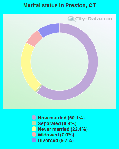
- Never married: 22.4%
- Now married: 60.1%
- Separated: 0.8%
- Widowed: 7.0%
- Divorced: 9.7%
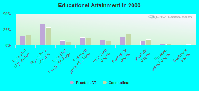
For population 25 years and over in Preston:
- High school or higher: 85.5%
- Bachelor's degree or higher: 22.6%
- Graduate or professional degree: 9.0%
- Unemployed: 3.4%
- Mean travel time to work (commute): 26.9 minutes
| Here: | 10.8 |
| Connecticut average: | 12.8 |
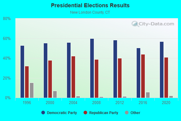
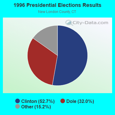
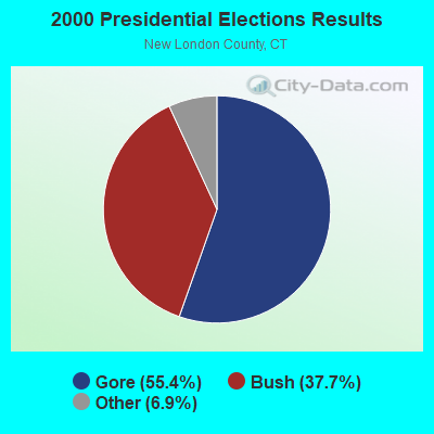

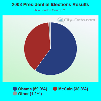

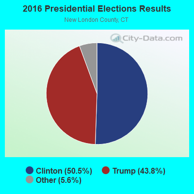
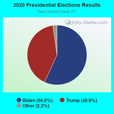
Graphs represent county-level data. Detailed 2008 Election Results
Religion statistics for Preston, CT (based on New London County data)
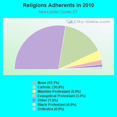
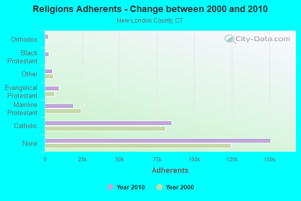
| Religion | Adherents | Congregations |
|---|---|---|
| Catholic | 84,765 | 34 |
| Mainline Protestant | 18,993 | 79 |
| Evangelical Protestant | 9,320 | 75 |
| Other | 5,022 | 32 |
| Black Protestant | 2,594 | 10 |
| Orthodox | 2,456 | 4 |
| None | 150,905 | - |
Food Environment Statistics:
| This county: | 1.82 / 10,000 pop. |
| State: | 2.21 / 10,000 pop. |
| Here: | 0.11 / 10,000 pop. |
| State: | 0.07 / 10,000 pop. |
| New London County: | 1.36 / 10,000 pop. |
| State: | 1.02 / 10,000 pop. |
| New London County: | 3.22 / 10,000 pop. |
| Connecticut: | 2.27 / 10,000 pop. |
| This county: | 10.01 / 10,000 pop. |
| State: | 9.19 / 10,000 pop. |
| New London County: | 7.6% |
| Connecticut: | 7.3% |
| This county: | 22.4% |
| Connecticut: | 21.5% |
| New London County: | 16.5% |
| Connecticut: | 15.8% |
6.16% of this county's 2021 resident taxpayers lived in other counties in 2020 ($81,025 average adjusted gross income)
| Here: | 6.16% |
| Connecticut average: | 5.79% |
0.04% of residents moved from foreign countries ($359 average AGI)
New London County: 0.04% Connecticut average: 0.02%
Top counties from which taxpayers relocated into this county between 2020 and 2021:
| from Hartford County, CT | |
| from Windham County, CT | |
| from Middlesex County, CT |
6.02% of this county's 2020 resident taxpayers moved to other counties in 2021 ($71,482 average adjusted gross income)
| Here: | 6.02% |
| Connecticut average: | 5.82% |
0.05% of residents moved to foreign countries ($502 average AGI)
New London County: 0.05% Connecticut average: 0.02%
Top counties to which taxpayers relocated from this county between 2020 and 2021:
| to Hartford County, CT | |
| to Windham County, CT | |
| to Middlesex County, CT |
Businesses in Preston, CT
- Dunkin Donuts: 2
- Subway: 1
Strongest AM radio stations in Preston:
- WICH (1310 AM; 5 kW; NORWICH, CT; Owner: WICH, INCORPORATED)
- WALE (990 AM; 50 kW; GREENVILLE, RI; Owner: NORTH AMERICAN BROADCASTING CO., INC.)
- WTIC (1080 AM; 50 kW; HARTFORD, CT; Owner: INFINITY RADIO OPERATIONS INC.)
- WCRN (830 AM; 50 kW; WORCESTER, MA; Owner: CARTER BROADCASTING CORPORATION)
- WNNZ (640 AM; 50 kW; WESTFIELD, MA; Owner: CLEAR CHANNEL BROADCASTING LICENSES, INC.)
- WEEI (850 AM; 50 kW; BOSTON, MA; Owner: ENTERCOM BOSTON LICENSE, LLC)
- WVNE (760 AM; daytime; 25 kW; LEICESTER, MA; Owner: BLOUNT MASSCOM, INC.)
- WSUB (980 AM; 1 kW; GROTON, CT; Owner: CITADEL BROADCASTING COMPANY)
- WRKO (680 AM; 50 kW; BOSTON, MA; Owner: ENTERCOM BOSTON LICENSE, LLC)
- WKOX (1200 AM; 50 kW; FRAMINGHAM, MA; Owner: CAPSTAR TX LIMITED PARTNERSHIP)
- WBIX (1060 AM; 40 kW; NATICK, MA; Owner: LANGER BROADCASTING CORPORATION)
- WAMG (890 AM; 25 kW; DEDHAM, MA; Owner: MEGA COMMUNICATIONS OF DEDHAM LICENSEE, LLC)
- WBZ (1030 AM; 50 kW; BOSTON, MA; Owner: INFINITY BROADCASTING OPERATIONS, INC.)
Strongest FM radio stations in Preston:
- WBMW (106.5 FM; LEDYARD, CT; Owner: RED WOLF BROADCASTING CORPORATION)
- WCTY (97.7 FM; NORWICH, CT; Owner: WICH, INC.)
- WHJM (107.7 FM; PAWCATUCK, CT; Owner: FULLER BROADCASTING INTERNATIONAL, LLC)
- WKNL (100.9 FM; NEW LONDON, CT; Owner: HALL COMMUNICATIONS, INC.)
- WWRX-FM (103.7 FM; WESTERLY, RI; Owner: FNX BROADCASTING OF RHODE ISLAND, LLC)
- WQGN-FM (105.5 FM; GROTON, CT; Owner: CITADEL BROADCASTING COMPANY)
- WILI-FM (98.3 FM; WILLIMANTIC, CT; Owner: NUTMEG BROADCASTING COMPANY)
- WXLM (102.3 FM; STONINGTON, CT; Owner: CITADEL BROADCASTING COMPANY)
- WECS (90.1 FM; WILLIMANTIC, CT; Owner: EASTERN CONNECTICUT STATE COLLEGE)
- WNLC (98.7 FM; EAST LYME, CT; Owner: HALL COMMUNICATIONS, INC.)
- WSKO-FM (99.7 FM; WAKEFIELD-PEACEDALE, RI; Owner: CITADEL BROADCASTING COMPANY)
- WCNI (90.9 FM; NEW LONDON, CT; Owner: CONNECTICUT COLLEGE BROADCASTING ASSOCIATION, INC.)
- WRCH (100.5 FM; NEW BRITAIN, CT; Owner: INFINITY RADIO OPERATIONS INC.)
- WHUS (91.7 FM; STORRS, CT; Owner: THE BD. OF TRUSTEES, THE UNIV. OF CT)
- W233AG (94.5 FM; NEW LONDON, CT; Owner: MONROE BOARD OF EDUCATION)
- WRIU (90.3 FM; KINGSTON, RI; Owner: UNIVERSITY OF RHODE ISLAND)
- W258AC (99.5 FM; STORRS, CT; Owner: CONNECTICUT PUBLIC BROADCASTING, INC)
- WNPR (89.1 FM; NORWICH, CT; Owner: CONNECTICUT PUBLIC B/NG, INC.)
TV broadcast stations around Preston:
- WHPX (Channel 26; NEW LONDON, CT; Owner: PAXSON HARTFORD LICENSE, INC.)
- WEDN (Channel 53; NORWICH, CT; Owner: CONNECTICUT PUBLIC BROADCASTING, INC.)
- WPXQ (Channel 69; BLOCK ISLAND, RI; Owner: OCEAN STATE TELEVISION, L.L.C.)
- WTIC-TV (Channel 61; HARTFORD, CT; Owner: TRIBUNE TELEVISION COMPANY)
- W11BJ (Channel 11; HARTFORD, CT; Owner: COMMUNICATIONS SITE MANAGEMENT LLC)
- WTXX (Channel 20; WATERBURY, CT; Owner: WTXX INC.)
- WYDN (Channel 48; WORCESTER, MA; Owner: EDUCATIONAL PUBLIC TV CORPORATION)
- WVIT (Channel 30; NEW BRITAIN, CT; Owner: OUTLET BROADCASTING, INC)
- WUVN (Channel 18; HARTFORD, CT; Owner: ENTRAVISION HOLDINGS, LLC)
- WEDH (Channel 24; HARTFORD, CT; Owner: CONNECTICUT PUBLIC BROADCASTING, INC.)
- National Bridge Inventory (NBI) Statistics
- 7Number of bridges
- 23ft / 7.2mTotal length
- 21,103Total average daily traffic
- 813Total average daily truck traffic
- 31,357Total future (year 2037) average daily traffic
FCC Registered Microwave Towers:
1- PRESTON TRAN, 21 Route 12 (Lat: 41.489028 Lon: -72.065222), Type: Building, Structure height: 16 m, Call Sign: WQRG372,
Assigned Frequencies: 11658.1 MHz, Grant Date: 02/10/2023, Expiration Date: 05/08/2033, Certifier: Paul Zito, Registrant: State Of Connecticut, 1111 Country Club Rd, Middletown, CT 06457, Phone: (860) 685-8080, Fax: (860) 685-8362, Email:
FCC Registered Amateur Radio Licenses:
47 (See the full list of FCC Registered Amateur Radio Licenses in Preston)FAA Registered Aircraft:
1- Aircraft: CESSNA 172M (Category: Land, Seats: 4, Weight: Up to 12,499 Pounds, Speed: 108 mph), Engine: LYCOMING 0-320 SERIES (180 HP) (4 Cycle)
N-Number: 13635, N13635, N-13635, Serial Number: 17262896, Year manufactured: 1974, Airworthiness Date: 01/30/1974, Certificate Issue Date: 12/05/1991
Registrant (Individual): Richard James Hartnett, 82 Cooktown Rd, Preston, CT 06365
2002 - 2018 National Fire Incident Reporting System (NFIRS) incidents
- Fire incident types reported to NFIRS in Preston, CT
- 20239.3%Outside Fires
- 19137.2%Structure Fires
- 11322.0%Mobile Property/Vehicle Fires
- 81.6%Other
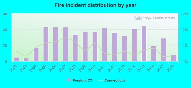 According to the data from the years 2002 - 2018 the average number of fires per year is 30. The highest number of reported fires - 44 took place in 2015, and the least - 4 in 2003. The data has a rising trend.
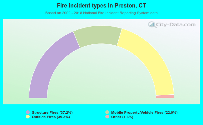 When looking into fire subcategories, the most incidents belonged to: Outside Fires (39.3%), and Structure Fires (37.2%).
- 80.9%Fuel oil, kerosene, etc.
- 10.4%Electricity
- 5.5%Wood
- 2.0%Bottled, tank, or LP gas
- 0.7%Utility gas
- 0.4%Coal or coke
- 74.0%Fuel oil, kerosene, etc.
- 14.3%Electricity
- 6.3%Bottled, tank, or LP gas
- 3.5%Wood
- 1.9%Utility gas
Preston compared to Connecticut state average:
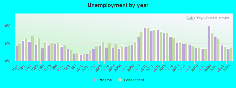
- Unemployed percentage significantly below state average.
- Black race population percentage significantly below state average.
- Hispanic race population percentage significantly below state average.
- Median age above state average.
- Foreign-born population percentage significantly below state average.
- Renting percentage below state average.
- Length of stay since moving in significantly above state average.
- Number of rooms per house significantly below state average.
- House age significantly below state average.

|
|
Total of 19 patent applications in 2008-2024.