West Bath, Maine
Submit your own pictures of this town and show them to the world
- OSM Map
- Google Map
- MSN Map
Population change since 2000: +4.4%
 |
| Males: 900 | |
| Females: 977 |
| Median resident age: | 47.7 years |
| Maine median age: | 43.0 years |
Zip codes: 04530.
| West Bath: | $85,508 |
| ME: | $69,543 |
Estimated per capita income in 2022: $47,975 (it was $23,022 in 2000)
West Bath town income, earnings, and wages data
Estimated median house or condo value in 2022: $408,108 (it was $139,000 in 2000)
| West Bath: | $408,108 |
| ME: | $290,600 |
Mean prices in 2022: all housing units: $359,191; detached houses: $377,995; townhouses or other attached units: $306,259; in 2-unit structures: $363,404; in 3-to-4-unit structures: $296,417; in 5-or-more-unit structures: $457,842; mobile homes: $167,878
Detailed information about poverty and poor residents in West Bath, ME


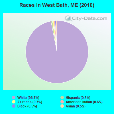
- 1,81596.7%White alone
- 150.8%Hispanic
- 140.7%Two or more races
- 120.6%American Indian alone
- 100.5%Black alone
- 90.5%Asian alone
- 10.05%Native Hawaiian and Other
Pacific Islander alone - 10.05%Other race alone
Races in West Bath detailed stats: ancestries, foreign born residents, place of birth
According to our research of Maine and other state lists, there were 2 registered sex offenders living in West Bath, Maine as of May 02, 2024.
The ratio of all residents to sex offenders in West Bath is 939 to 1.
The ratio of registered sex offenders to all residents in this city is lower than the state average.
 Recent articles from our blog. Our writers, many of them Ph.D. graduates or candidates, create easy-to-read articles on a wide variety of topics.
West Bath, ME City Guides:
Ancestries: English (25.3%), Irish (13.6%), French (11.1%), United States (10.5%), German (8.8%), Scottish (6.1%).
Current Local Time: EST time zone
Incorporated on 02/14/1844
Land area: 11.8 square miles.
Population density: 159 people per square mile (very low).
37 residents are foreign born (0.9% Europe, 0.5% Asia, 0.4% North America, 0.2% Latin America).
| This town: | 2.1% |
| Maine: | 2.9% |
| West Bath town: | 1.1% ($1,503) |
| Maine: | 1.5% ($1,417) |
Nearest city with pop. 50,000+: Portland, ME  (25.0 miles , pop. 64,249).
Nearest city with pop. 200,000+: Boston, MA (123.9 miles , pop. 589,141).
Nearest city with pop. 1,000,000+: Bronx, NY (293.0 miles , pop. 1,332,650).
Nearest cities:
), ), Latitude: 43.87 N, Longitude: 69.86 W
Area code commonly used in this area: 207
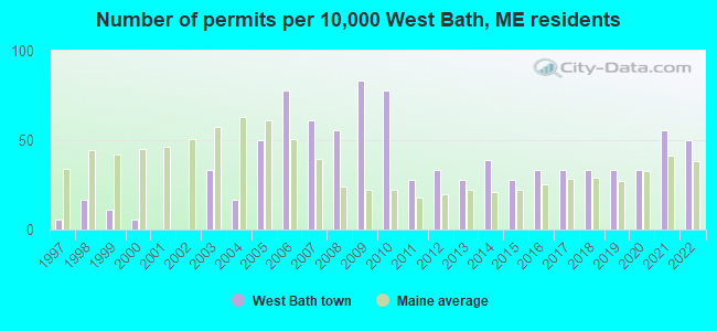
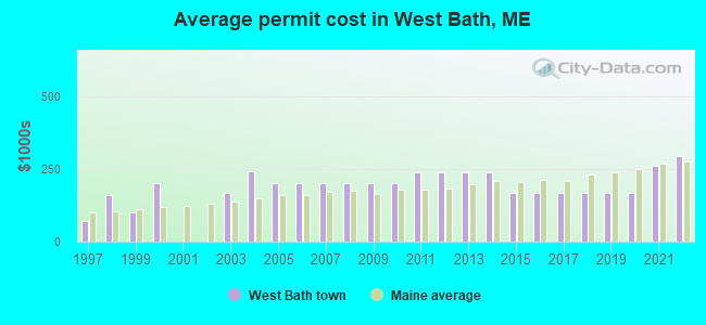
Single-family new house construction building permits:
- 2022: 9 buildings, average cost: $294,700
- 2021: 10 buildings, average cost: $262,500
- 2020: 6 buildings, average cost: $166,700
- 2019: 6 buildings, average cost: $166,700
- 2018: 6 buildings, average cost: $166,700
- 2017: 6 buildings, average cost: $166,700
- 2016: 6 buildings, average cost: $166,700
- 2015: 5 buildings, average cost: $166,700
- 2014: 7 buildings, average cost: $240,000
- 2013: 5 buildings, average cost: $240,000
- 2012: 6 buildings, average cost: $240,000
- 2011: 5 buildings, average cost: $240,000
- 2010: 14 buildings, average cost: $200,000
- 2009: 15 buildings, average cost: $200,000
- 2008: 10 buildings, average cost: $200,000
- 2007: 11 buildings, average cost: $200,000
- 2006: 14 buildings, average cost: $200,000
- 2005: 9 buildings, average cost: $200,000
- 2004: 3 buildings, average cost: $241,700
- 2003: 6 buildings, average cost: $166,700
- 2000: 1 building, cost: $200,000
- 1999: 2 buildings, average cost: $100,000
- 1998: 3 buildings, average cost: $159,700
- 1997: 1 building, cost: $71,600
| Here: | 3.6% |
| Maine: | 3.4% |

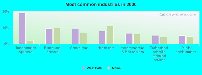
- Transportation equipment (19.1%)
- Educational services (9.5%)
- Construction (9.3%)
- Health care (8.0%)
- Accommodation & food services (6.5%)
- Professional, scientific, technical services (5.3%)
- Public administration (5.1%)
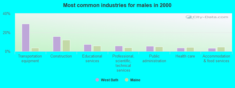
- Transportation equipment (29.2%)
- Construction (15.9%)
- Educational services (7.4%)
- Professional, scientific, technical services (5.8%)
- Public administration (5.4%)
- Health care (3.8%)
- Accommodation & food services (3.4%)

- Health care (12.8%)
- Educational services (11.9%)
- Accommodation & food services (10.0%)
- Transportation equipment (7.4%)
- Finance & insurance (5.1%)
- Professional, scientific, technical services (4.7%)
- Public administration (4.7%)
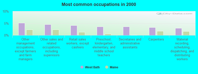
- Other management occupations, except farmers and farm managers (5.2%)
- Other sales and related occupations, including supervisors (4.5%)
- Retail sales workers, except cashiers (4.1%)
- Preschool, kindergarten, elementary, and middle school teachers (3.6%)
- Secretaries and administrative assistants (3.6%)
- Carpenters (3.3%)
- Material recording, scheduling, dispatching, and distributing workers (3.0%)
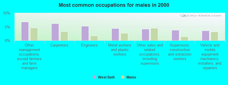
- Other management occupations, except farmers and farm managers (6.8%)
- Carpenters (6.2%)
- Engineers (5.2%)
- Metal workers and plastic workers (4.4%)
- Other sales and related occupations, including supervisors (4.2%)
- Supervisors, construction and extraction workers (3.8%)
- Vehicle and mobile equipment mechanics, installers, and repairers (3.6%)

- Secretaries and administrative assistants (7.7%)
- Other office and administrative support workers, including supervisors (6.5%)
- Preschool, kindergarten, elementary, and middle school teachers (5.6%)
- Retail sales workers, except cashiers (5.3%)
- Other sales and related occupations, including supervisors (4.9%)
- Waiters and waitresses (3.5%)
- Bookkeeping, accounting, and auditing clerks (3.5%)
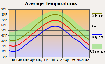
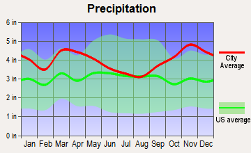
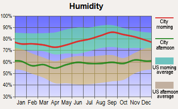
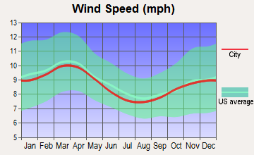
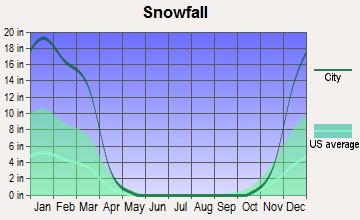
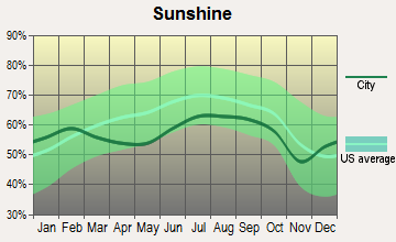
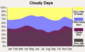
Average climate in West Bath, Maine
Based on data reported by over 4,000 weather stations
(lower is better)
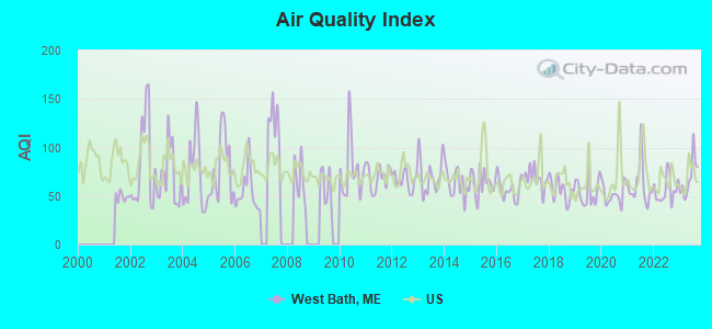
Air Quality Index (AQI) level in 2023 was 69.2. This is about average.
| City: | 69.2 |
| U.S.: | 72.6 |
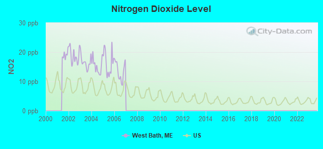
Nitrogen Dioxide (NO2) [ppb] level in 2006 was 13.6. This is significantly worse than average. Closest monitor was 23.6 miles away from the city center.
| City: | 13.6 |
| U.S.: | 5.1 |
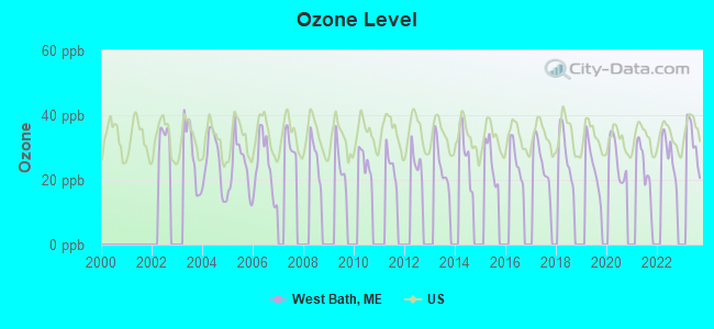
Ozone [ppb] level in 2023 was 31.7. This is about average. Closest monitor was 7.7 miles away from the city center.
| City: | 31.7 |
| U.S.: | 33.3 |
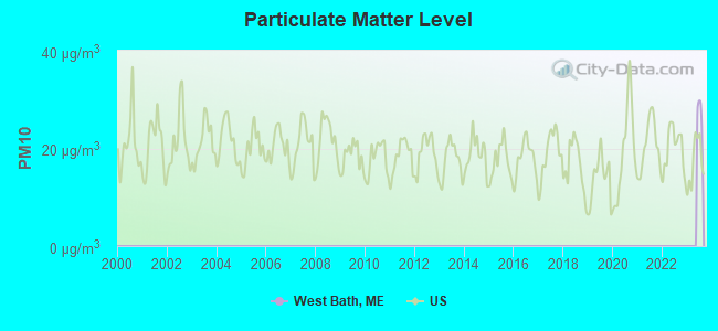
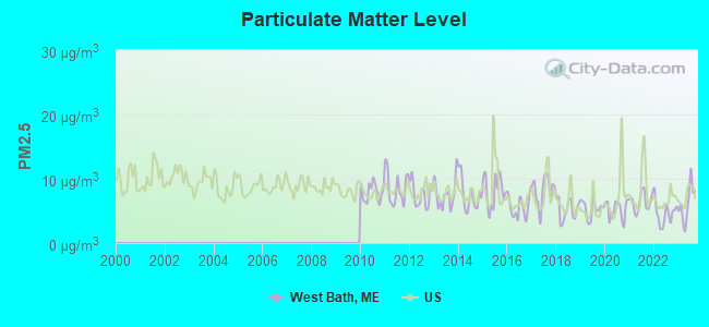
Particulate Matter (PM2.5) [µg/m3] level in 2023 was 6.16. This is better than average. Closest monitor was 23.2 miles away from the city center.
| City: | 6.16 |
| U.S.: | 8.11 |
Earthquake activity:
West Bath-area historical earthquake activity is significantly above Maine state average. It is 76% smaller than the overall U.S. average.On 10/16/2012 at 23:12:25, a magnitude 4.7 (4.7 ML, Depth: 10.0 mi, Class: Light, Intensity: IV - V) earthquake occurred 44.1 miles away from West Bath center
On 4/20/2002 at 10:50:47, a magnitude 5.3 (5.3 ML, Depth: 3.0 mi, Class: Moderate, Intensity: VI - VII) earthquake occurred 195.4 miles away from West Bath center
On 1/19/1982 at 00:14:42, a magnitude 4.7 (4.5 MB, 4.7 MD, 4.5 LG) earthquake occurred 90.8 miles away from West Bath center
On 4/20/2002 at 10:50:47, a magnitude 5.2 (5.2 MB, 4.2 MS, 5.2 MW, 5.0 MW) earthquake occurred 196.1 miles away from the city center
On 10/7/1983 at 10:18:46, a magnitude 5.3 (5.1 MB, 5.3 LG, 5.1 ML) earthquake occurred 223.4 miles away from West Bath center
On 2/26/1999 at 03:38:43, a magnitude 3.8 (3.8 LG, Depth: 2.0 mi, Class: Light, Intensity: II - III) earthquake occurred 45.3 miles away from the city center
Magnitude types: regional Lg-wave magnitude (LG), body-wave magnitude (MB), duration magnitude (MD), local magnitude (ML), surface-wave magnitude (MS), moment magnitude (MW)
Natural disasters:
The number of natural disasters in Sagadahoc County (19) is greater than the US average (15).Major Disasters (Presidential) Declared: 14
Emergencies Declared: 4
Causes of natural disasters: Floods: 12, Storms: 10, Winter Storms: 6, Hurricanes: 2, Snows: 2, Blizzard: 1, Ice Storm: 1, Snowfall: 1, Snowstorm: 1, Wind: 1, Other: 1 (Note: some incidents may be assigned to more than one category).
Hospitals and medical centers near West Bath:
- COASTAL DIALYSIS CENTER (Dialysis Facility, about 3 miles away; BATH, ME)
- WINSHIP GREEN NURSING CENTER (Nursing Home, about 5 miles away; BATH, ME)
- DIONNE COMMONS (Nursing Home, about 7 miles away; BRUNSWICK, ME)
- HORIZONS LIVING AND REHAB CENTER (Nursing Home, about 7 miles away; BRUNSWICK, ME)
- COMMUNITY HEALTH AND NURSING SERVICES (Home Health Center, about 7 miles away; BRUNSWICK, ME)
- MID COAST SENIOR HEALTH CENTER (Nursing Home, about 7 miles away; BRUNSWICK, ME)
- BRUNSWICK MANOR (Nursing Home, about 7 miles away; BRUNSWICK, ME)
Heliports located in West Bath:
Colleges/universities with over 2000 students nearest to West Bath:
- Southern Maine Community College (about 25 miles; South Portland, ME; Full-time enrollment: 4,666)
- University of Southern Maine (about 26 miles; Portland, ME; FT enrollment: 6,647)
- Saint Joseph's College of Maine (about 32 miles; Standish, ME; FT enrollment: 2,010)
- University of Maine at Augusta (about 33 miles; Augusta, ME; FT enrollment: 3,204)
- University of New England (about 39 miles; Biddeford, ME; FT enrollment: 4,539)
- University of Maine at Farmington (about 57 miles; Farmington, ME; FT enrollment: 2,036)
- University of New Hampshire-Main Campus (about 75 miles; Durham, NH; FT enrollment: 15,243)
Public elementary/middle school in West Bath:
- WEST BATH SCHOOL (Location: 126 NEW MEADOWS ROAD, Grades: KG-5)
Points of interest:
Notable location: West Bath Volunteer Fire Department (A). Display/hide its location on the map
Church in West Bath: West Bath Church (A). Display/hide its location on the map
Cemeteries: Work Lee Cemetery (1), First Parish Cemetery (2). Display/hide their locations on the map
Lakes, reservoirs, and swamps: Birchwood Pond (A), Campbell Pond (B), Houghton Pond (C), New Meadows (D). Display/hide their locations on the map
Creek: Dam Cove Creek (A). Display/hide its location on the map
Court: Maine State - Courts- District Court (147 New Meadows Road) (1). Display/hide its approximate location on the map
| This town: | 2.3 people |
| Maine: | 2.3 people |
| This town: | 69.8% |
| Whole state: | 62.9% |
| This town: | 7.2% |
| Whole state: | 9.4% |
Likely homosexual households (counted as self-reported same-sex unmarried-partner households)
- Lesbian couples: 0.4% of all households
- Gay men: 0.0% of all households
| This town: | 6.6% |
| Whole state: | 10.9% |
| This town: | 3.2% |
| Whole state: | 4.1% |
2 people in homes for the mentally retarded in 2000
For population 15 years and over in West Bath:
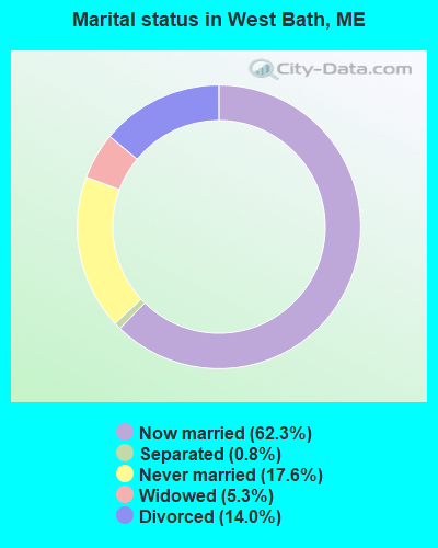
- Never married: 17.6%
- Now married: 62.3%
- Separated: 0.8%
- Widowed: 5.3%
- Divorced: 14.0%
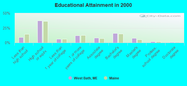
For population 25 years and over in West Bath:
- High school or higher: 90.7%
- Bachelor's degree or higher: 26.8%
- Graduate or professional degree: 10.8%
- Unemployed: 3.6%
- Mean travel time to work (commute): 20.4 minutes

| Here: | 9.9 |
| Maine average: | 11.2 |
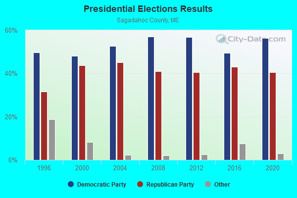
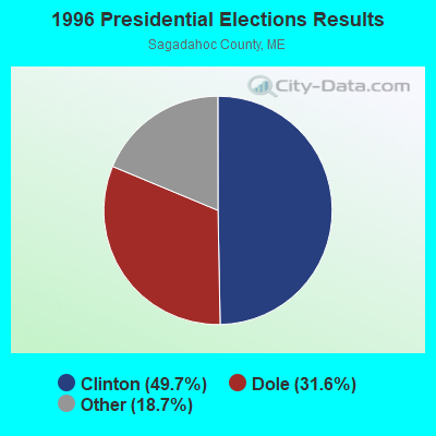
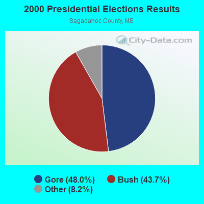


Graphs represent county-level data. Detailed 2008 Election Results
Religion statistics for West Bath, ME (based on Sagadahoc County data)
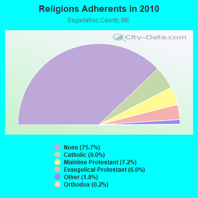
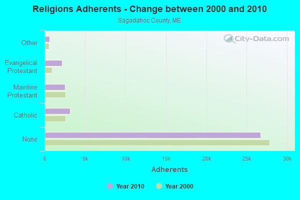
| Religion | Adherents | Congregations |
|---|---|---|
| Catholic | 3,177 | 3 |
| Mainline Protestant | 2,527 | 15 |
| Evangelical Protestant | 2,134 | 20 |
| Other | 646 | 2 |
| Orthodox | 88 | 1 |
| None | 26,721 | - |
Food Environment Statistics:
| Sagadahoc County: | 1.65 / 10,000 pop. |
| State: | 2.80 / 10,000 pop. |
| Here: | 1.93 / 10,000 pop. |
| Maine: | 2.20 / 10,000 pop. |
| Sagadahoc County: | 4.40 / 10,000 pop. |
| State: | 5.75 / 10,000 pop. |
| Sagadahoc County: | 10.18 / 10,000 pop. |
| Maine: | 11.02 / 10,000 pop. |
| Sagadahoc County: | 7.7% |
| Maine: | 8.2% |
| Sagadahoc County: | 26.5% |
| Maine: | 25.0% |
Businesses in West Bath, ME
- FedEx: 1
- U-Haul: 1
Strongest AM radio stations in West Bath:
- WJTO (730 AM; 1 kW; BATH, ME; Owner: BLUE JEY BROADCASTING COMPANY)
- WJJB (900 AM; 1 kW; BRUNSWICK, ME; Owner: ATLANTIC COAST RADIO, LLC)
- WGAN (560 AM; 5 kW; PORTLAND, ME; Owner: SAGA COMMUNICATIONS OF NEW ENGLAND, LLC)
- WMTW (870 AM; 10 kW; GORHAM, ME; Owner: RADIO PARTNERS OF MAINE, L.P.)
- WLAM (1470 AM; 5 kW; LEWISTON, ME; Owner: RADIO PARTNERS OF MAINE, L.P.)
- WZAN (970 AM; 5 kW; PORTLAND, ME; Owner: SAGA COMMUNICATIONS OF NEW ENGLAND, LLC)
- WFAU (1280 AM; 5 kW; GARDINER, ME; Owner: CAPSTAR TX LIMITED PARTNERSHIP)
- WLOB (1310 AM; 5 kW; PORTLAND, ME; Owner: ATLANTIC COAST RADIO, LLC)
- WRKO (680 AM; 50 kW; BOSTON, MA; Owner: ENTERCOM BOSTON LICENSE, LLC)
- WJAE (1440 AM; 5 kW; WESTBROOK, ME; Owner: ALTANTIC COAST RADIO, LLC)
- WTME (780 AM; 10 kW; RUMFORD, ME; Owner: MOUNTAIN VALLEY BROADCASTING, INC.)
- WEEI (850 AM; 50 kW; BOSTON, MA; Owner: ENTERCOM BOSTON LICENSE, LLC)
- WBZ (1030 AM; 50 kW; BOSTON, MA; Owner: INFINITY BROADCASTING OPERATIONS, INC.)
Strongest FM radio stations in West Bath:
- WCLZ (98.9 FM; BRUNSWICK, ME; Owner: CITADEL BROADCASTING COMPANY)
- WJJB-FM (95.5 FM; TOPSHAM, ME; Owner: ATLANTIC COAST RADIO, LLC)
- WBCI (105.9 FM; BATH, ME; Owner: BLOUNT COMMUNICATIONS, INC.)
- WTHT (107.5 FM; LEWISTON, ME; Owner: RADIO PARTNERS OF MAINE, L.P.)
- WBLM (102.9 FM; PORTLAND, ME; Owner: CITADEL BROADCASTING COMPANY)
- WJBQ (97.9 FM; PORTLAND, ME; Owner: CITADEL BROADCASTING COMPANY)
- WMEA (90.1 FM; PORTLAND, ME; Owner: MAINE PUBLIC BROADCASTING CORPORATION)
- WYFP (91.9 FM; HARPSWELL, ME; Owner: BIBLE BROADCASTING NETWORK, INC.)
- WPKQ (103.7 FM; NORTH CONWAY, NH; Owner: CITADEL BROADCASTING COMPANY)
- WHOM (94.9 FM; MT. WASHINGTON, NH; Owner: CITADEL BROADCASTING COMPANY)
- WCYI (93.9 FM; LEWISTON, ME; Owner: CITADEL BROADCASTING COMPANY)
- WMEK-FM (99.9 FM; AUBURN, ME; Owner: RADIO PARTNERS OF MAINE, L.P.)
- WMTW-FM (106.7 FM; NORTH WINDHAM, ME; Owner: RADIO PARTNERS OF MAINE, L.P.)
- WCME (96.7 FM; BOOTHBAY HARBOR, ME; Owner: CAPSTAR TX LIMITED PARTNERSHIP)
- WPOR (101.9 FM; PORTLAND, ME; Owner: SAGA COMMUNICATIONS OF NEW ENGLAND, LLC)
- WYNZ (100.9 FM; WESTBROOK, ME; Owner: SAGA COMMUNICATIONS OF NEW ENGLAND, LLC)
- WMEP (90.5 FM; CAMDEN, ME; Owner: MAINE PUBLIC BROADCASTING CORP.)
- WQSS (102.5 FM; CAMDEN, ME; Owner: CLEAR CHANNEL BROADCASTING LICENSES, INC.)
- WMSJ (89.3 FM; FREEPORT, ME; Owner: DOWNEAST CHRISTIAN COMMUNICATIONS)
- WMGX (93.1 FM; PORTLAND, ME; Owner: SAGA COMMUNICATIONS OF NEW ENGLAND, LLC)
TV broadcast stations around West Bath:
- WGME-TV (Channel 13; PORTLAND, ME; Owner: WGME LICENSEE, LLC)
- WPFO (Channel 23; WATERVILLE, ME; Owner: CMCG PORTLAND LICENSE LLC)
- WPXT (Channel 51; PORTLAND, ME; Owner: HMW, INC.)
- WMTW-TV (Channel 8; POLAND SPRING, ME; Owner: WMTW BROADCAST GROUP, LLC)
- WCBB (Channel 10; AUGUSTA, ME; Owner: MAINE PUBLIC BROADCASTING CORP.)
- WPME (Channel 35; LEWISTON, ME; Owner: KB PRIME MEDIA LLC)
- WCSH (Channel 6; PORTLAND, ME; Owner: PACIFIC AND SOUTHERN COMPANY, INC.)
- W32CA (Channel 32; PORTLAND, ME; Owner: NATIONAL MINORITY T.V., INC.)
- W29CA (Channel 29; BRUNSWICK, ME; Owner: CRAIG MINISTRIES)
West Bath fatal accident list:
- National Bridge Inventory (NBI) Statistics
- 4Number of bridges
- 92ft / 27.9mTotal length
- 54,563Total average daily traffic
- 2,726Total average daily truck traffic
- 76,388Total future (year 2036) average daily traffic
FCC Registered Cell Phone Towers:
2 (See the full list of FCC Registered Cell Phone Towers in West Bath)FCC Registered Antenna Towers:
25 (See the full list of FCC Registered Antenna Towers)FCC Registered Broadcast Land Mobile Towers:
1- Route 1 (Lat: 43.902306 Lon: -69.845111), Type: Tower, Structure height: 60.3 m, Call Sign: WPCY926,
Assigned Frequencies: 154.295 MHz, Grant Date: 05/24/2023, Expiration Date: 08/20/2033, Registrant: Jep Telecom Licensing Services, 3045 Mcvitty Forest Drive, Unit 102, Cave Spring, VA 24018-3563, Phone: (941) 441-6830, Email:
FCC Registered Microwave Towers:
1- West Bath, Route 1 (Lat: 43.902306 Lon: -69.845111), Type: Mtower, Structure height: 54.9 m, Overall height: 57.9 m, Call Sign: WQZI863,
Assigned Frequencies: 19460.0 MHz, 19460.0 MHz, 19460.0 MHz, 19460.0 MHz, 19460.0 MHz, 19460.0 MHz, 19460.0 MHz, 19460.0 MHz, 19460.0 MHz, 10735.0 MHz... (+3 more), Grant Date: 06/02/2017, Expiration Date: 06/02/2027, Certifier: Brodie Hinkley, Registrant: Radio Communications Management, Inc., 158 Rand Rd, Portland, ME 04102, Phone: (207) 797-7503, Fax: (207) 878-3521, Email:
FCC Registered Paging Towers:
3- Witch Spring Hill (Lat: 43.904222 Lon: -69.847250), Call Sign: KNKM203,
Assigned Frequencies: 75.9400 MHz, Grant Date: 05/09/2009, Expiration Date: 04/01/2019, Cancellation Date: 05/18/2019, Certifier: Andrew Fitton, Registrant: Lukas, Nace, Gutierrez & Sachs, LLP, 8300 Greensboro Drive, Suite 1200, Mclean, VA 22102, Phone: (703) 584-8663, Fax: (703) 584-8695, Email:
- Witch Spring Hill (Lat: 43.904222 Lon: -69.847250), Overall height: 48.8 m, Call Sign: KNKP759,
Assigned Frequencies: 931.437 MHz, Grant Date: 05/09/2009, Expiration Date: 04/01/2019, Cancellation Date: 05/18/2019, Certifier: Andrew Fitton, Registrant: Lukas, Nace, Gutierrez & Sachs, LLP, 8300 Greensboro Drive, Suite 1200, Mclean, VA 22102, Phone: (703) 584-8663, Fax: (703) 584-8695, Email:
- Witch Spring Hill (Lat: 43.904222 Lon: -69.847250), Call Sign: KNKG859,
Assigned Frequencies: 75.7000 MHz, Grant Date: 05/09/2009, Expiration Date: 04/01/2019, Cancellation Date: 05/18/2019, Certifier: Andrew Fitton, Registrant: Lukas, Nace, Gutierrez & Sachs, LLP, 8300 Greensboro Drive, Suite 1200, Mclean, VA 22102, Phone: (703) 584-8663, Fax: (703) 584-8695, Email:
FCC Registered Amateur Radio Licenses:
20 (See the full list of FCC Registered Amateur Radio Licenses in West Bath)FAA Registered Aircraft:
6- Aircraft: ROBINSON HELICOPTER COMPANY R22 MARINER (Category: Amphibian, Seats: 2, Weight: Up to 12,499 Pounds), Engine: LYCOMING 0-320 SERIES (180 HP) (Reciprocating)
N-Number: 369SR, N369SR, N-369SR, Serial Number: 1017M, Year manufactured: 1989, Airworthiness Date: 04/21/1989, Certificate Issue Date: 07/30/2013
Registrant (LLC): Chopper Shots LLC, 44 Corgi Ln, West Bath, ME 04530 - Aircraft: CESSNA A185F (Category: Land, Seats: 6, Weight: Up to 12,499 Pounds, Speed: 127 mph), Engine: CONT MOTOR IO 520 SERIES (285 HP) (Reciprocating)
N-Number: 5217E, N5217E, N-5217E, Serial Number: 18503941, Airworthiness Date: 05/19/1997, Certificate Issue Date: 10/22/2020
Registrant (Individual): Thomas R Ramsey, 41 Northward Rd, West Bath, ME 04530 - Aircraft: CARD DONALD J ZENITH CH750 CRUZER (Category: Land, Seats: 2, Weight: Up to 12,499 Pounds), Engine: Reciprocating
N-Number: 719BD, N719BD, N-719BD, Serial Number: C75-10315, Certificate Issue Date: 01/27/2020
Registrant (Individual): Donald J Card, 72 Indian Carry Rd, West Bath, ME 04530 - Aircraft: CESSNA 172N (Category: Land, Seats: 4, Weight: Up to 12,499 Pounds, Speed: 105 mph), Engine: LYCOMING 0-320 SERIES (180 HP) (Reciprocating)
N-Number: 733MV, N733MV, N-733MV, Serial Number: 17268405, Year manufactured: 1976, Airworthiness Date: 12/21/1976, Certificate Issue Date: 01/14/2019
Registrant (Individual): Thomas R Jr Ramsey, 41 Northwood Rd, West Bath, ME 04530 - Aircraft: PIPER J3C-65 (Category: Land, Seats: 2, Weight: Up to 12,499 Pounds, Speed: 67 mph), Engine: CONT MOTOR A&C65 SERIES (65 HP) (Reciprocating)
N-Number: 88069, N88069, N-88069, Serial Number: 15685, Year manufactured: 1946, Airworthiness Date: 03/24/1956, Certificate Issue Date: 09/10/1986
Registrant (Individual): Gregory E Bridgman, 93 Shoal Cove Rd, West Bath, ME 04530 - Aircraft: CIRRUS DESIGN CORP SR22 (Category: Land, Seats: 4, Weight: Up to 12,499 Pounds), Engine: CONT MOTOR IO-550 SERIES (300 HP) (Reciprocating)
N-Number: 747LJ, N747LJ, N-747LJ, Serial Number: 0535, Year manufactured: 2003, Airworthiness Date: 04/30/2003, Certificate Issue Date: 05/24/2017
Registrant (LLC): Papa Whisky 1 LLC, 85 Harbor Ridge Rd, West Bath, ME 04530
Deregistered: Cancel Date: 09/04/2020
2002 - 2018 National Fire Incident Reporting System (NFIRS) incidents
- Fire incident types reported to NFIRS in West Bath, ME
- 10945.6%Other
- 7230.1%Structure Fires
- 3514.6%Outside Fires
- 239.6%Mobile Property/Vehicle Fires
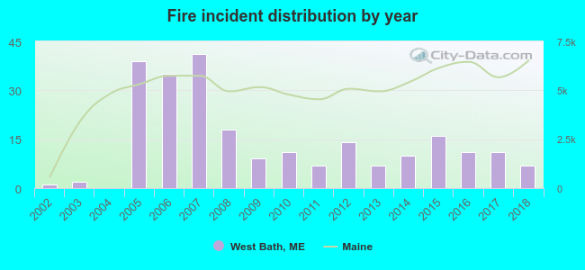 Based on the data from the years 2002 - 2018 the average number of fires per year is 14. The highest number of fires - 41 took place in 2007, and the least - 0 in 2004. The data has a growing trend.
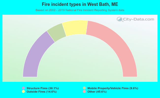 When looking into fire subcategories, the most incidents belonged to: Other (45.6%), and Structure Fires (30.1%).
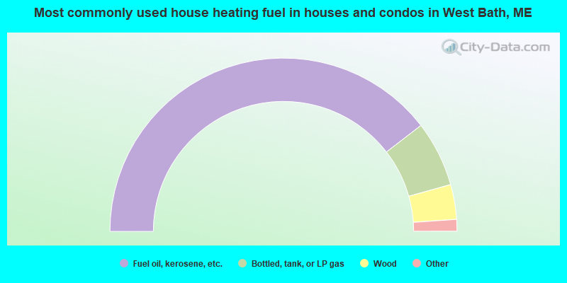
- 79.1%Fuel oil, kerosene, etc.
- 12.2%Bottled, tank, or LP gas
- 6.5%Wood
- 1.2%Electricity
- 0.3%Coal or coke
- 0.3%Other fuel
- 0.3%No fuel used
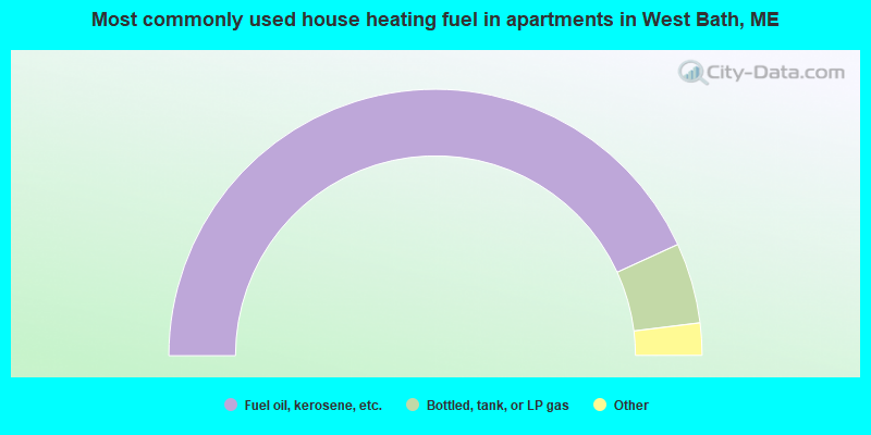
- 86.3%Fuel oil, kerosene, etc.
- 9.8%Bottled, tank, or LP gas
- 2.6%Wood
- 1.3%Utility gas
West Bath compared to Maine state average:
- Unemployed percentage significantly below state average.
- Black race population percentage below state average.
- Hispanic race population percentage below state average.
- Median age above state average.
- Foreign-born population percentage below state average.
- Length of stay since moving in significantly above state average.
- Number of rooms per house significantly below state average.
- House age significantly below state average.