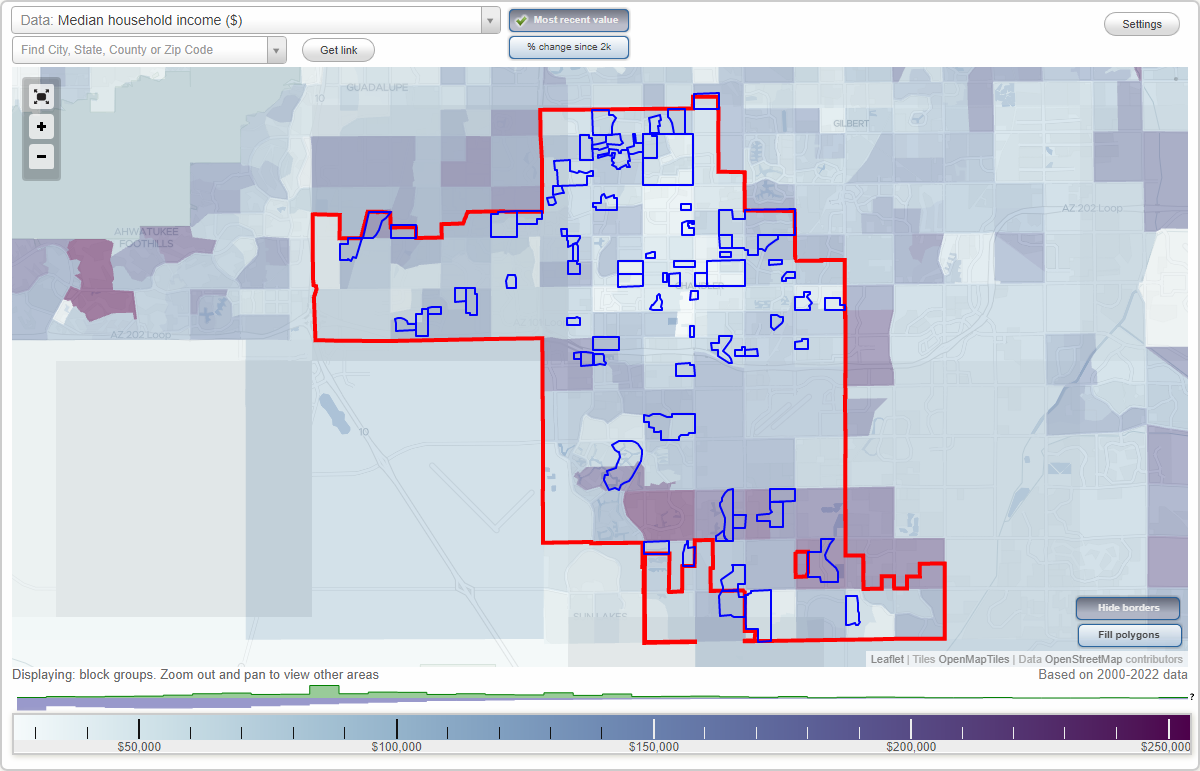
Chandler, Arizona Neighborhood Map - Income, House Prices, Occupations, Boundaries
Settings
X

- City boundary
- Neighborhood boundaries
Business Search - 14 Million verified businesses
Neighborhoods:
Amberwood North, Arcadia Village, Arizona Reflections, Arrowhead Meadows, Arrowhead Meadows II, Autumn Lane, Cantabria Shores, Carino Estates, Carrington Place, Chandler Ranch, Chieftain Village, Circle G Riggs Ranch, Colonia Coronita, Cooper Corners West, Country Peace, Cove at Tiburon, Dobson Estates, Downtown Chandler Historic District, Galveston, Glenview Estates, Homestead, Hoy Homes, Indian Mesa East, Ironwood Vistas, Kerby Estates, Knoll East, Knoll East Unit Seven, La Casitas Del Sur, Lagos Vistoso, McQueen Lakes, Monte Vista, New Horizons, Oakwood Lakes, Olsen Addition, Orange Tree, Park Manor, Paseo Crossings, Pecos Vistas, Pepperwood, Pine Lake, Provinces Master, Ranchitos de Oro, Ranchos de Chandler, Ray Manor, Ray Ranch, Rio Del Verde, San Marcos Country, Shawnee Park, Silk Stocking, Silverton Ranch, Southmoore, Springfield Adult, Springfield Lakes, Stellar City Air Park, Sunnycrest, Sunridge, Sunset Park Manor, Sunshine Valley, Superstition Ranch, Symphony Estates, Tealstone Ray Ranch, Terraces at Tiburon Condo, Trade Winds, Traditions East, Traditions East Parcel, Trails End Estates, Tremaine Park, Tristan, Valencia, Villa Pallavicini, Warner Ranch, Warner Ranch IV, Windmills West, Windrose East, WoodglenAmberwood North neighborhood in Chandler statistics: (Find on map)
Area: 1.007 square miles
Population: 4,791
Population density:
Median household income in 2021:
Median rent in in 2021:
Male vs Females
Median age
Housing prices:
Average estimated value of detached houses in 2021 (64.9% of all units):
Average estimated value of townhouses or other attached units in 2021 (10.2% of all units):
Most popular occupations of males: service occupations (17.9%); sales and office occupations (14.8%); management occupations (except farmers) (12.2%); transportation occupations (8.2%); architecture and engineering occupations (5.1%); production occupations (5.0%); construction, extraction, and maintenance occupations (4.9%)
Most popular occupations of females: sales and office occupations (30.2%); healthcare practitioners and technical occupations (16.8%); service occupations (13.2%); business and financial operations occupations (12.9%); education, training, and library occupations (11.2%); management occupations (except farmers) (5.7%); computer and mathematical occupations (3.8%)
Highways in this neighborhood: State Hwy 87 (N Arizona Ave).
Roads and streets: W Palomino Dr; W Warner Rd; W el Prado Rd; N Evergreen St; W Mission Dr; W Shawnee Dr; W el Alba Way; W el Monte Pl; W Barrow Dr; W Cheyenne Dr; W Mesquite St; W Nopal Pl; N Hartford St; N Jay St; N Nebraska St; W Rosal Pl; W Alamo Dr; W Marlboro Dr; W Loughlin Dr; N Pleasant Dr; W Grace Blvd; W Sundance Way; W Mariposa St; N Oregon St; N Grace Blvd; N Cheri Lynn Dr; W Marlboro Cir; North Dakota St; N Arbor Ln; W Elliot Rd; N Sunset Dr; W Colt Rd; W Los Arboles Pl; N Illinois St; W Comstock Dr; N Holguin Way; W Copper Way; N Cheri Lynn Ct; N Garrett Dr; N Iowa St; W Shawnee St; N el Alba Way; W Nebraska St.
Amberwood North neighborhood detailed profile
Area: 1.007 square miles
Population: 4,791
Population density:
| Amberwood North: | 4,756 people per square mile |
| Chandler: | 4,827 people per square mile |
Median household income in 2021:
| Amberwood North: | $73,963 |
| Chandler: | $94,613 |
Median rent in in 2021:
| Amberwood North: | $1,134 |
| Chandler: | $1,458 |
Male vs Females
| Males: | 2,235 |
| Females: | 2,556 |
Median age
| Males: | 38.2 years |
| Females: | 42.2 years |
Housing prices:
Average estimated value of detached houses in 2021 (64.9% of all units):
| Amberwood North: | $275,546 |
| Chandler: | $374,792 |
Average estimated value of townhouses or other attached units in 2021 (10.2% of all units):
| This neighborhood: | $206,943 |
| city: | $199,254 |
Most popular occupations of males: service occupations (17.9%); sales and office occupations (14.8%); management occupations (except farmers) (12.2%); transportation occupations (8.2%); architecture and engineering occupations (5.1%); production occupations (5.0%); construction, extraction, and maintenance occupations (4.9%)
Most popular occupations of females: sales and office occupations (30.2%); healthcare practitioners and technical occupations (16.8%); service occupations (13.2%); business and financial operations occupations (12.9%); education, training, and library occupations (11.2%); management occupations (except farmers) (5.7%); computer and mathematical occupations (3.8%)
Highways in this neighborhood: State Hwy 87 (N Arizona Ave).
Roads and streets: W Palomino Dr; W Warner Rd; W el Prado Rd; N Evergreen St; W Mission Dr; W Shawnee Dr; W el Alba Way; W el Monte Pl; W Barrow Dr; W Cheyenne Dr; W Mesquite St; W Nopal Pl; N Hartford St; N Jay St; N Nebraska St; W Rosal Pl; W Alamo Dr; W Marlboro Dr; W Loughlin Dr; N Pleasant Dr; W Grace Blvd; W Sundance Way; W Mariposa St; N Oregon St; N Grace Blvd; N Cheri Lynn Dr; W Marlboro Cir; North Dakota St; N Arbor Ln; W Elliot Rd; N Sunset Dr; W Colt Rd; W Los Arboles Pl; N Illinois St; W Comstock Dr; N Holguin Way; W Copper Way; N Cheri Lynn Ct; N Garrett Dr; N Iowa St; W Shawnee St; N el Alba Way; W Nebraska St.
Amberwood North neighborhood detailed profile
Arcadia Village neighborhood in Chandler statistics: (Find on map)
Area: 0.023 square miles
Roads and streets: N Jackson St.
Arcadia Village neighborhood detailed profile
Area: 0.023 square miles
Roads and streets: N Jackson St.
Arcadia Village neighborhood detailed profile
Arizona Reflections neighborhood in Chandler statistics: (Find on map)
Area: 0.108 square miles
Population: 467
Population density:
Median household income in 2021:
Median rent in in 2021:
Male vs Females
Median age
Average estimated value of detached houses in 2021 (100.0% of all units):
Most popular occupations of males: sales and office occupations (29.8%); healthcare practitioners and technical occupations (11.4%); computer and mathematical occupations (10.7%); management occupations (except farmers) (9.1%); service occupations (8.2%); business and financial operations occupations (7.4%); material moving occupations (5.1%)
Most popular occupations of females: sales and office occupations (34.4%); life, physical, and social science occupations (20.4%); management occupations (except farmers) (16.1%); service occupations (9.0%); education, training, and library occupations (7.7%); production occupations (5.8%); business and financial operations occupations (5.0%)
Roads and streets: S Hamilton St; E Reflection Pl; S Bogle Ct; S Mosley Dr; S Jackson St; E Derringer Way; S San Vincente Ct; E Winchester Dr; E Woodsman Pl; S Anvil Pl; E Banelli Pl; S Wagon Wheel Dr; E Ruger Dr; E Browning Way; E Winchester Way; E Springfield Pl; S Maverick Ct; E Flinlock Pl; S Fargo Ct; S Fresno Ct; S Mosley Ct; S Firehole Dr; S Wagon Wheel Ct; S Crossbow Ct; E Sako Pl; E Gunstock Rd; S Gunstock Rd.
Arizona Reflections neighborhood detailed profile
Area: 0.108 square miles
Population: 467
Population density:
| Arizona Reflections: | 4,323 people per square mile |
| Chandler: | 4,827 people per square mile |
Median household income in 2021:
| Arizona Reflections: | $82,604 |
| Chandler: | $94,613 |
Median rent in in 2021:
| Arizona Reflections: | $1,641 |
| Chandler: | $1,458 |
Male vs Females
| Males: | 270 |
| Females: | 197 |
Median age
| Males: | 32.7 years |
| Females: | 33.7 years |
Average estimated value of detached houses in 2021 (100.0% of all units):
| Arizona Reflections: | $296,202 |
| Chandler: | $374,792 |
Most popular occupations of males: sales and office occupations (29.8%); healthcare practitioners and technical occupations (11.4%); computer and mathematical occupations (10.7%); management occupations (except farmers) (9.1%); service occupations (8.2%); business and financial operations occupations (7.4%); material moving occupations (5.1%)
Most popular occupations of females: sales and office occupations (34.4%); life, physical, and social science occupations (20.4%); management occupations (except farmers) (16.1%); service occupations (9.0%); education, training, and library occupations (7.7%); production occupations (5.8%); business and financial operations occupations (5.0%)
Roads and streets: S Hamilton St; E Reflection Pl; S Bogle Ct; S Mosley Dr; S Jackson St; E Derringer Way; S San Vincente Ct; E Winchester Dr; E Woodsman Pl; S Anvil Pl; E Banelli Pl; S Wagon Wheel Dr; E Ruger Dr; E Browning Way; E Winchester Way; E Springfield Pl; S Maverick Ct; E Flinlock Pl; S Fargo Ct; S Fresno Ct; S Mosley Ct; S Firehole Dr; S Wagon Wheel Ct; S Crossbow Ct; E Sako Pl; E Gunstock Rd; S Gunstock Rd.
Arizona Reflections neighborhood detailed profile
Arrowhead Meadows neighborhood in Chandler statistics: (Find on map)
Area: 0.130 square miles
Population: 1,086
Population density:
Median household income in 2021:
Median rent in in 2021:
Male vs Females
Median age
Average estimated value of detached houses in 2021 (47.8% of all units):
Most popular occupations of males: construction, extraction, and maintenance occupations (47.6%); sales and office occupations (12.6%); architecture and engineering occupations (10.9%); business and financial operations occupations (4.5%); service occupations (3.9%); management occupations (except farmers) (3.1%); material moving occupations (3.1%)
Most popular occupations of females: service occupations (39.5%); architecture and engineering occupations (17.5%); business and financial operations occupations (9.9%); sales and office occupations (8.7%); computer and mathematical occupations (7.8%); material moving occupations (6.2%); education, training, and library occupations (5.0%)
Roads and streets: W Galveston St; W Erie St; N Central Dr; N Alma School Rd; W Tulsa St; W Oakland St; W Tyson St; N Apache Dr; N Comanche Dr; N Chippewa Dr; N Meadows Dr.
Arrowhead Meadows neighborhood detailed profile
Area: 0.130 square miles
Population: 1,086
Population density:
| Arrowhead Meadows: | 8,371 people per square mile |
| Chandler: | 4,827 people per square mile |
Median household income in 2021:
| Arrowhead Meadows: | $70,415 |
| Chandler: | $94,613 |
Median rent in in 2021:
| Arrowhead Meadows: | $1,006 |
| Chandler: | $1,458 |
Male vs Females
| Males: | 610 |
| Females: | 476 |
Median age
| Males: | 41.7 years |
| Females: | 34.5 years |
Average estimated value of detached houses in 2021 (47.8% of all units):
| Arrowhead Meadows: | $346,798 |
| Chandler: | $374,792 |
Most popular occupations of males: construction, extraction, and maintenance occupations (47.6%); sales and office occupations (12.6%); architecture and engineering occupations (10.9%); business and financial operations occupations (4.5%); service occupations (3.9%); management occupations (except farmers) (3.1%); material moving occupations (3.1%)
Most popular occupations of females: service occupations (39.5%); architecture and engineering occupations (17.5%); business and financial operations occupations (9.9%); sales and office occupations (8.7%); computer and mathematical occupations (7.8%); material moving occupations (6.2%); education, training, and library occupations (5.0%)
Roads and streets: W Galveston St; W Erie St; N Central Dr; N Alma School Rd; W Tulsa St; W Oakland St; W Tyson St; N Apache Dr; N Comanche Dr; N Chippewa Dr; N Meadows Dr.
Arrowhead Meadows neighborhood detailed profile
Arrowhead Meadows II neighborhood in Chandler statistics: (Find on map)
Area: 0.127 square miles
Population: 829
Population density:
Median household income in 2021:
Median rent in in 2021:
Male vs Females
Median age
Average estimated value of detached houses in 2021 (56.5% of all units):
Most popular occupations of males: construction, extraction, and maintenance occupations (39.8%); sales and office occupations (14.8%); architecture and engineering occupations (10.9%); business and financial operations occupations (5.7%); management occupations (except farmers) (4.6%); service occupations (4.1%); material moving occupations (2.8%)
Most popular occupations of females: service occupations (34.5%); sales and office occupations (16.8%); architecture and engineering occupations (13.7%); business and financial operations occupations (7.9%); management occupations (except farmers) (7.7%); education, training, and library occupations (6.4%); computer and mathematical occupations (6.2%)
Roads and streets: W Chandler Blvd; N Chippewa Pl; N Alma School Rd; W Toledo St; W Flint St; N Meadows Dr; N Comanche Dr; N Apache Dr.
Arrowhead Meadows II neighborhood detailed profile
Area: 0.127 square miles
Population: 829
Population density:
| Arrowhead Meadows II: | 6,502 people per square mile |
| Chandler: | 4,827 people per square mile |
Median household income in 2021:
| Arrowhead Meadows II: | $66,077 |
| Chandler: | $94,613 |
Median rent in in 2021:
| Arrowhead Meadows II: | $1,008 |
| Chandler: | $1,458 |
Male vs Females
| Males: | 466 |
| Females: | 362 |
Median age
| Males: | 35.2 years |
| Females: | 31.5 years |
Average estimated value of detached houses in 2021 (56.5% of all units):
| Arrowhead Meadows II: | $345,725 |
| Chandler: | $374,792 |
Most popular occupations of males: construction, extraction, and maintenance occupations (39.8%); sales and office occupations (14.8%); architecture and engineering occupations (10.9%); business and financial operations occupations (5.7%); management occupations (except farmers) (4.6%); service occupations (4.1%); material moving occupations (2.8%)
Most popular occupations of females: service occupations (34.5%); sales and office occupations (16.8%); architecture and engineering occupations (13.7%); business and financial operations occupations (7.9%); management occupations (except farmers) (7.7%); education, training, and library occupations (6.4%); computer and mathematical occupations (6.2%)
Roads and streets: W Chandler Blvd; N Chippewa Pl; N Alma School Rd; W Toledo St; W Flint St; N Meadows Dr; N Comanche Dr; N Apache Dr.
Arrowhead Meadows II neighborhood detailed profile
Autumn Lane neighborhood in Chandler statistics: (Find on map)
Area: 0.015 square miles
Roads and streets: N Blackstone Dr; W Gary Dr; W Park Ave; N Woodburne Dr; N Bullmoose Dr.
Autumn Lane neighborhood detailed profile
Area: 0.015 square miles
Roads and streets: N Blackstone Dr; W Gary Dr; W Park Ave; N Woodburne Dr; N Bullmoose Dr.
Autumn Lane neighborhood detailed profile
Cantabria Shores neighborhood in Chandler statistics: (Find on map)
Area: 0.428 square miles
Roads and streets: SE Jacaranda Pkwy; W Island Cir; S Cantabria Cir; S Vista Pl; W Honeysuckle Ln; S Rosemary Dr; W Island Dr; S Horizon Pl; W Indigo Dr; W Rockrose Way; W Marina Dr; S Vista Dr; S Marigold Pl; W Lantana Dr; W Sunrise Pl; S Clubhouse Dr; W Redwood Dr; S Meadows Dr; W Wisteria Dr; S Marigold Way; W Wisteria Ct; W Carob Dr; NW Jacaranda Pkwy.
Cantabria Shores neighborhood detailed profile
Carino Estates neighborhood in Chandler statistics: (Find on map)
Area: 0.381 square miles
Highways in this neighborhood: S Arizona Ave (State Hwy 87).
Roads and streets: W Raven Dr; W Oriole Way; W Canary Way; W Goldfinch Way; W Roadrunner Dr; W Ryan Rd; S Hartford St; W Hawk Way; S Holguin Way; W Bluejay Dr; S Tumbleweed Ln; W Cardinal Way; W Queen Creek Rd; S Camellia Dr; S Iowa St; S Eileen Dr; S Sunland Dr; S Leonard Pl; South Dakota St; S Nebraska St; W Cardianl Way; S Pleasant Dr; S California St; S Illinois Pl; S Oregon St; W Goldfinch Ct; S Beverly Pl; S Pleasant Pl; S McClelland Pl; W Crane Ct; S Beverly St; S Emerson St; S Felix Way; W Roadrunner Ct; W Crane Dr; S Camellia Ct; S Sunland Ct.
Carino Estates neighborhood detailed profile
Carrington Place neighborhood in Chandler statistics: (Find on map)
Area: 0.077 square miles
Roads and streets: W Kesler St; W Geronimo St; W Frye Rd; S Oak St; S Aspen Dr; W Morelos St; W Saragosa St; S Fir St; S Tyler Ct; S Oak St Cir (S Oak Cir).
Carrington Place neighborhood detailed profile
Area: 0.077 square miles
Roads and streets: W Kesler St; W Geronimo St; W Frye Rd; S Oak St; S Aspen Dr; W Morelos St; W Saragosa St; S Fir St; S Tyler Ct; S Oak St Cir (S Oak Cir).
Carrington Place neighborhood detailed profile
Chandler Ranch neighborhood in Chandler statistics: (Find on map)
Area: 0.048 square miles
Roads and streets: S Canal Dr; E Elgin St; E Whitten St; S Sandi Ln; E Tara Ct.
Chandler Ranch neighborhood detailed profile
Area: 0.048 square miles
Roads and streets: S Canal Dr; E Elgin St; E Whitten St; S Sandi Ln; E Tara Ct.
Chandler Ranch neighborhood detailed profile
Chieftain Village neighborhood in Chandler statistics: (Find on map)
Area: 0.020 square miles
Population: 243
Population density:
Median household income in 2021:
Median rent in in 2021:
Male vs Females
Median age
Most popular occupations of males: business and financial operations occupations (79.6%); construction, extraction, and maintenance occupations (55.1%); transportation occupations (31.3%); healthcare practitioners and technical occupations (29.4%); production occupations (26.3%); arts, design, entertainment, sports, and media occupations (21.7%); service occupations (20.4%)
Most popular occupations of females: education, training, and library occupations (63.0%); management occupations (except farmers) (61.7%); service occupations (36.3%); sales and office occupations (32.6%); material moving occupations (19.2%); legal occupations (17.2%); arts, design, entertainment, sports, and media occupations (16.0%)
Highways in this neighborhood: S Arizona Ave (State Hwy 87).
Chieftain Village neighborhood detailed profile
Area: 0.020 square miles
Population: 243
Population density:
| Chieftain Village: | 12,081 people per square mile |
| Chandler: | 4,827 people per square mile |
Median household income in 2021:
| Chieftain Village: | $43,800 |
| Chandler: | $94,613 |
Median rent in in 2021:
| Chieftain Village: | $968 |
| Chandler: | $1,458 |
Male vs Females
| Males: | 116 |
| Females: | 127 |
Median age
| Males: | 22.9 years |
| Females: | 23.6 years |
Most popular occupations of males: business and financial operations occupations (79.6%); construction, extraction, and maintenance occupations (55.1%); transportation occupations (31.3%); healthcare practitioners and technical occupations (29.4%); production occupations (26.3%); arts, design, entertainment, sports, and media occupations (21.7%); service occupations (20.4%)
Most popular occupations of females: education, training, and library occupations (63.0%); management occupations (except farmers) (61.7%); service occupations (36.3%); sales and office occupations (32.6%); material moving occupations (19.2%); legal occupations (17.2%); arts, design, entertainment, sports, and media occupations (16.0%)
Highways in this neighborhood: S Arizona Ave (State Hwy 87).
Chieftain Village neighborhood detailed profile
Circle G Riggs Ranch neighborhood in Chandler statistics: (Find on map)
Area: 0.315 square miles
Roads and streets: S Riggs Ranch Rd; E Virgo Pl; S Desert Homestead Rd; E Cloud Dr (E Cloud St); E Country Shadows Rd (E Scorpio Pl); S Ashley Dr; E Libra Pl; S 132nd St (S Riggs Ranch Rd); E Elmwood Pl (Via de Arboles); E Cedar Pl; E Taurus Pl (E Vallejo St); E Victoria St; E Villa Park St (E Capricorn Pl); Eastern Canal Rd; E Cherrywood Pl; E Birchwood Pl; E Vista Verde Dr; E Beechnut Ct; E Teakwood Pl; E Wood Pl.
Circle G Riggs Ranch neighborhood detailed profile
Colonia Coronita neighborhood in Chandler statistics: (Find on map)
Area: 0.085 square miles
Roads and streets: E Frye Rd; E Cindy St; S Cottonwood St; E Boston St; E Butler St; S Eucalyptus Pl; E Chicago St; S Salt Cedar St; S Salt Cedar; E Buffalo St; S Salt Cedar Pl; N Cottonwood St; Cottonwood St.
Colonia Coronita neighborhood detailed profile
Area: 0.085 square miles
Roads and streets: E Frye Rd; E Cindy St; S Cottonwood St; E Boston St; E Butler St; S Eucalyptus Pl; E Chicago St; S Salt Cedar St; S Salt Cedar; E Buffalo St; S Salt Cedar Pl; N Cottonwood St; Cottonwood St.
Colonia Coronita neighborhood detailed profile
Cooper Corners West neighborhood in Chandler statistics: (Find on map)
Area: 0.127 square miles
Roads and streets: E Grand Canyon Dr; E Glacier Pl; E Yellowstone Pl; E Zion Way; S Cambridge St; S Melody Dr; S Marion Pl; S John Way; S Rio Dr; S Tower Ave; S Danyell Dr; S Leoma Ln; S Soho Ln; E Yellowstone Dr; S Amber St.
Cooper Corners West neighborhood detailed profile
Country Peace neighborhood in Chandler statistics: (Find on map)
Area: 0.083 square miles
Roads and streets: E Boston St; E Cindy St; E Chicago St; S Laurelwood; S Country Pl; Jupiter Way; S Catalina St; S Heather Ln; S Spartan St; E Butler St; S Gilbert Rd; S Pine St; S Dove Ln; S Beth Ln; E Frye Rd.
Country Peace neighborhood detailed profile
Area: 0.083 square miles
Roads and streets: E Boston St; E Cindy St; E Chicago St; S Laurelwood; S Country Pl; Jupiter Way; S Catalina St; S Heather Ln; S Spartan St; E Butler St; S Gilbert Rd; S Pine St; S Dove Ln; S Beth Ln; E Frye Rd.
Country Peace neighborhood detailed profile
Cove at Tiburon neighborhood in Chandler statistics: (Find on map)
Area: 0.031 square miles
Population: 72
Population density:
Median household income in 2021:
Median rent in in 2021:
Male vs Females
Median age
Average estimated value of detached houses in 2021 (100.0% of all units):
Most popular occupations of males: sales and office occupations (48.6%); management occupations (except farmers) (25.4%); service occupations (4.9%); computer and mathematical occupations (3.2%); transportation occupations (3.2%); business and financial operations occupations (2.8%); healthcare practitioners and technical occupations (2.8%)
Most popular occupations of females: sales and office occupations (32.7%); service occupations (25.1%); computer and mathematical occupations (13.5%); healthcare practitioners and technical occupations (10.4%); education, training, and library occupations (8.8%); management occupations (except farmers) (3.2%); business and financial operations occupations (3.2%)
Roads and streets: W Brooks St; W Estrella Dr; W Temple St; N Blackstone Dr; N Ellis St; N Lexington Dr.
Cove at Tiburon neighborhood detailed profile
Area: 0.031 square miles
Population: 72
Population density:
| Cove at Tiburon: | 2,357 people per square mile |
| Chandler: | 4,827 people per square mile |
Median household income in 2021:
| Cove at Tiburon: | $79,299 |
| Chandler: | $94,613 |
Median rent in in 2021:
| Cove at Tiburon: | $1,375 |
| Chandler: | $1,458 |
Male vs Females
| Males: | 31 |
| Females: | 41 |
Median age
| Males: | 37.0 years |
| Females: | 34.0 years |
Average estimated value of detached houses in 2021 (100.0% of all units):
| Cove at Tiburon: | $418,372 |
| Chandler: | $374,792 |
Most popular occupations of males: sales and office occupations (48.6%); management occupations (except farmers) (25.4%); service occupations (4.9%); computer and mathematical occupations (3.2%); transportation occupations (3.2%); business and financial operations occupations (2.8%); healthcare practitioners and technical occupations (2.8%)
Most popular occupations of females: sales and office occupations (32.7%); service occupations (25.1%); computer and mathematical occupations (13.5%); healthcare practitioners and technical occupations (10.4%); education, training, and library occupations (8.8%); management occupations (except farmers) (3.2%); business and financial operations occupations (3.2%)
Roads and streets: W Brooks St; W Estrella Dr; W Temple St; N Blackstone Dr; N Ellis St; N Lexington Dr.
Cove at Tiburon neighborhood detailed profile
Dobson Estates neighborhood in Chandler statistics: (Find on map)
Area: 0.056 square miles
Population: 314
Population density:
Median household income in 2021:
Median rent in in 2021:
Male vs Females
Median age
Average estimated value of detached houses in 2021 (100.0% of all units):
Most popular occupations of males: sales and office occupations (27.4%); management occupations (except farmers) (22.9%); production occupations (9.3%); service occupations (6.2%); construction, extraction, and maintenance occupations (5.7%); business and financial operations occupations (3.9%); life, physical, and social science occupations (3.3%)
Most popular occupations of females: sales and office occupations (30.1%); service occupations (26.5%); management occupations (except farmers) (16.0%); education, training, and library occupations (9.3%); business and financial operations occupations (5.1%); healthcare practitioners and technical occupations (3.5%); community and social services occupations (3.1%)
Roads and streets: W Shawnee Dr; N Karen Dr; W Palo Verde Dr; N Verde Dr.
Dobson Estates neighborhood detailed profile
Area: 0.056 square miles
Population: 314
Population density:
| Dobson Estates: | 5,648 people per square mile |
| Chandler: | 4,827 people per square mile |
Median household income in 2021:
| Dobson Estates: | $80,344 |
| Chandler: | $94,613 |
Median rent in in 2021:
| Dobson Estates: | $1,366 |
| Chandler: | $1,458 |
Male vs Females
| Males: | 168 |
| Females: | 145 |
Median age
| Males: | 39.8 years |
| Females: | 37.3 years |
Average estimated value of detached houses in 2021 (100.0% of all units):
| Dobson Estates: | $314,678 |
| Chandler: | $374,792 |
Most popular occupations of males: sales and office occupations (27.4%); management occupations (except farmers) (22.9%); production occupations (9.3%); service occupations (6.2%); construction, extraction, and maintenance occupations (5.7%); business and financial operations occupations (3.9%); life, physical, and social science occupations (3.3%)
Most popular occupations of females: sales and office occupations (30.1%); service occupations (26.5%); management occupations (except farmers) (16.0%); education, training, and library occupations (9.3%); business and financial operations occupations (5.1%); healthcare practitioners and technical occupations (3.5%); community and social services occupations (3.1%)
Roads and streets: W Shawnee Dr; N Karen Dr; W Palo Verde Dr; N Verde Dr.
Dobson Estates neighborhood detailed profile
Downtown Chandler Historic District neighborhood in Chandler statistics: (Find on map)
Area: 0.026 square miles
Population: 346
Population density:
Median household income in 2021:
Median rent in in 2021:
Male vs Females
Median age
Housing prices:
Average estimated value of detached houses in 2021 (36.0% of all units):
Average estimated value of townhouses or other attached units in 2021 (3.6% of all units):
Most popular occupations of males: service occupations (28.4%); sales and office occupations (19.1%); material moving occupations (12.2%); computer and mathematical occupations (11.7%); management occupations (except farmers) (11.0%); business and financial operations occupations (10.9%); healthcare practitioners and technical occupations (5.7%)
Most popular occupations of females: service occupations (38.3%); sales and office occupations (32.3%); education, training, and library occupations (9.1%); healthcare practitioners and technical occupations (7.1%); business and financial operations occupations (5.5%); production occupations (3.0%); management occupations (except farmers) (2.5%)
Highways in this neighborhood: S Arizona Ave (State Hwy 87).
Roads and streets: E Buffalo St; E Boston St; N Arizona Pl; N San Marcos Pl; S San Marcos Pl; S Arizona Pl; W Buffalo St; W Boston St.
Downtown Chandler Historic District neighborhood detailed profile
Area: 0.026 square miles
Population: 346
Population density:
| Downtown Chandler Historic District: | 13,526 people per square mile |
| Chandler: | 4,827 people per square mile |
Median household income in 2021:
| Downtown Chandler Historic District: | $45,781 |
| Chandler: | $94,613 |
Median rent in in 2021:
| Downtown Chandler Historic District: | $1,124 |
| Chandler: | $1,458 |
Male vs Females
| Males: | 146 |
| Females: | 200 |
Median age
| Males: | 25.3 years |
| Females: | 27.4 years |
Housing prices:
Average estimated value of detached houses in 2021 (36.0% of all units):
| Downtown Chandler Historic District: | $274,397 |
| Chandler: | $374,792 |
Average estimated value of townhouses or other attached units in 2021 (3.6% of all units):
| This neighborhood: | $416,724 |
| city: | $199,254 |
Most popular occupations of males: service occupations (28.4%); sales and office occupations (19.1%); material moving occupations (12.2%); computer and mathematical occupations (11.7%); management occupations (except farmers) (11.0%); business and financial operations occupations (10.9%); healthcare practitioners and technical occupations (5.7%)
Most popular occupations of females: service occupations (38.3%); sales and office occupations (32.3%); education, training, and library occupations (9.1%); healthcare practitioners and technical occupations (7.1%); business and financial operations occupations (5.5%); production occupations (3.0%); management occupations (except farmers) (2.5%)
Highways in this neighborhood: S Arizona Ave (State Hwy 87).
Roads and streets: E Buffalo St; E Boston St; N Arizona Pl; N San Marcos Pl; S San Marcos Pl; S Arizona Pl; W Buffalo St; W Boston St.
Downtown Chandler Historic District neighborhood detailed profile
Galveston neighborhood in Chandler statistics: (Find on map)
Area: 0.383 square miles
Population: 483
Population density:
Median household income in 2021:
Median rent in in 2021:
Male vs Females
Median age
Average estimated value of townhouses or other attached units in 2021 (17.9% of all units):
Most popular occupations of males: service occupations (23.5%); sales and office occupations (18.9%); material moving occupations (16.1%); management occupations (except farmers) (13.9%); construction, extraction, and maintenance occupations (9.2%); transportation occupations (9.2%); business and financial operations occupations (7.6%)
Most popular occupations of females: service occupations (33.5%); healthcare practitioners and technical occupations (19.7%); education, training, and library occupations (17.6%); life, physical, and social science occupations (14.9%); material moving occupations (12.2%); architecture and engineering occupations (8.1%); production occupations (6.8%)
Roads and streets: E Erie St; E Detroit St; E Chandler Blvd; E Oakland St; E Flint St; E Tyson St; N McQueen Rd; N Jackson St; E Carla Vista Dr; N Hamilton St; N Exeter St; N Fresno St; E Tulsa St; N Ithica St; E Toledo St; N Kingston St; N Monte Vista St; N Williams St; E San Tan St; E Carla Vista Pl; N Nevada St; E Galveston St.
Galveston neighborhood detailed profile
Area: 0.383 square miles
Population: 483
Population density:
| Galveston: | 1,263 people per square mile |
| Chandler: | 4,827 people per square mile |
Median household income in 2021:
| Galveston: | $63,675 |
| Chandler: | $94,613 |
Median rent in in 2021:
| Galveston: | $1,286 |
| Chandler: | $1,458 |
Male vs Females
| Males: | 255 |
| Females: | 227 |
Median age
| Males: | 32.3 years |
| Females: | 27.7 years |
Average estimated value of townhouses or other attached units in 2021 (17.9% of all units):
| This neighborhood: | $212,167 |
| city: | $199,254 |
Most popular occupations of males: service occupations (23.5%); sales and office occupations (18.9%); material moving occupations (16.1%); management occupations (except farmers) (13.9%); construction, extraction, and maintenance occupations (9.2%); transportation occupations (9.2%); business and financial operations occupations (7.6%)
Most popular occupations of females: service occupations (33.5%); healthcare practitioners and technical occupations (19.7%); education, training, and library occupations (17.6%); life, physical, and social science occupations (14.9%); material moving occupations (12.2%); architecture and engineering occupations (8.1%); production occupations (6.8%)
Roads and streets: E Erie St; E Detroit St; E Chandler Blvd; E Oakland St; E Flint St; E Tyson St; N McQueen Rd; N Jackson St; E Carla Vista Dr; N Hamilton St; N Exeter St; N Fresno St; E Tulsa St; N Ithica St; E Toledo St; N Kingston St; N Monte Vista St; N Williams St; E San Tan St; E Carla Vista Pl; N Nevada St; E Galveston St.
Galveston neighborhood detailed profile
Glenview Estates neighborhood in Chandler statistics: (Find on map)
Area: 0.060 square miles
Roads and streets: S Galaxy Dr; N Galaxy Dr; S Kenneth Pl; W Williams Field Rd (W Chandler Blvd).
Glenview Estates neighborhood detailed profile
Area: 0.060 square miles
Roads and streets: S Galaxy Dr; N Galaxy Dr; S Kenneth Pl; W Williams Field Rd (W Chandler Blvd).
Glenview Estates neighborhood detailed profile
Homestead neighborhood in Chandler statistics: (Find on map)
Area: 0.059 square miles
Roads and streets: N Bullmoose Cir; W Bullmoose Cir.
Homestead neighborhood detailed profile
Area: 0.059 square miles
Roads and streets: N Bullmoose Cir; W Bullmoose Cir.
Homestead neighborhood detailed profile
Hoy Homes neighborhood in Chandler statistics: (Find on map)
Area: 0.051 square miles
Population: 817
Population density:
Median household income in 2021:
Median rent in in 2021:
Male vs Females
Median age
Average estimated value of detached houses in 2021 (62.8% of all units):
Most popular occupations of males: construction, extraction, and maintenance occupations (23.7%); sales and office occupations (18.9%); service occupations (11.8%); material moving occupations (8.4%); computer and mathematical occupations (8.0%); architecture and engineering occupations (6.4%); production occupations (5.7%)
Most popular occupations of females: sales and office occupations (27.5%); service occupations (21.4%); healthcare practitioners and technical occupations (14.1%); education, training, and library occupations (12.6%); business and financial operations occupations (11.9%); material moving occupations (6.9%); production occupations (5.6%)
Highways in this neighborhood: State Hwy 87 (N Arizona Ave).
Roads and streets: W Oakland St; W Tulsa St; N California St; N Nebraska St.
Hoy Homes neighborhood detailed profile
Area: 0.051 square miles
Population: 817
Population density:
| Hoy Homes: | 16,062 people per square mile |
| Chandler: | 4,827 people per square mile |
Median household income in 2021:
| Hoy Homes: | $57,143 |
| Chandler: | $94,613 |
Median rent in in 2021:
| Hoy Homes: | $1,004 |
| Chandler: | $1,458 |
Male vs Females
| Males: | 374 |
| Females: | 443 |
Median age
| Males: | 29.3 years |
| Females: | 34.9 years |
Average estimated value of detached houses in 2021 (62.8% of all units):
| Hoy Homes: | $273,855 |
| Chandler: | $374,792 |
Most popular occupations of males: construction, extraction, and maintenance occupations (23.7%); sales and office occupations (18.9%); service occupations (11.8%); material moving occupations (8.4%); computer and mathematical occupations (8.0%); architecture and engineering occupations (6.4%); production occupations (5.7%)
Most popular occupations of females: sales and office occupations (27.5%); service occupations (21.4%); healthcare practitioners and technical occupations (14.1%); education, training, and library occupations (12.6%); business and financial operations occupations (11.9%); material moving occupations (6.9%); production occupations (5.6%)
Highways in this neighborhood: State Hwy 87 (N Arizona Ave).
Roads and streets: W Oakland St; W Tulsa St; N California St; N Nebraska St.
Hoy Homes neighborhood detailed profile
Indian Mesa East neighborhood in Chandler statistics: (Find on map)
Area: 0.029 square miles
Roads and streets: N Tamarisk St; W Harrison St.
Indian Mesa East neighborhood detailed profile
Area: 0.029 square miles
Roads and streets: N Tamarisk St; W Harrison St.
Indian Mesa East neighborhood detailed profile
Ironwood Vistas neighborhood in Chandler statistics: (Find on map)
Area: 0.088 square miles
Roads and streets: S Tanglewood Dr; S California St; W Wood Dr; W Mahogany Pl; W Cedar Dr; W Birchwood Pl; W Beechnut Pl; W Teakwood Pl; W Elmwood Pl; S Eileen Dr; W Nolan Way; California St.
Ironwood Vistas neighborhood detailed profile
Area: 0.088 square miles
Roads and streets: S Tanglewood Dr; S California St; W Wood Dr; W Mahogany Pl; W Cedar Dr; W Birchwood Pl; W Beechnut Pl; W Teakwood Pl; W Elmwood Pl; S Eileen Dr; W Nolan Way; California St.
Ironwood Vistas neighborhood detailed profile
Kerby Estates neighborhood in Chandler statistics: (Find on map)
Area: 0.180 square miles
Roads and streets: S Kerby Way; S Crossbow Way; S 118th St; S Anvil Pl; S Crossbow Pl; E Coconino Dr; E Brooks Farm Rd; E Prescott Dr; E Kaibab Dr; E Tonto Dr; E Glacier Dr; E Canyon Way; E Powell Way; E Grand Canyon Dr; E Mead Dr; E Chandler Heights Rd; E Crescent Pl; E Blue Ridge Way; E San Carlos Way; E Lynx Pl; Consolidated.
Other features: Consolidated Canal East Br.
Kerby Estates neighborhood detailed profile
Knoll East neighborhood in Chandler statistics: (Find on map)
Area: 0.091 square miles
Population: 484
Population density:
Median household income in 2021:
Median rent in in 2021:
Male vs Females
Median age
Average estimated value of detached houses in 2021 (99.0% of all units):
Most popular occupations of males: sales and office occupations (31.2%); management occupations (except farmers) (18.8%); construction, extraction, and maintenance occupations (7.6%); production occupations (6.8%); service occupations (5.6%); business and financial operations occupations (5.3%); computer and mathematical occupations (5.3%)
Most popular occupations of females: sales and office occupations (38.1%); service occupations (24.2%); management occupations (except farmers) (14.3%); education, training, and library occupations (7.9%); business and financial operations occupations (4.9%); arts, design, entertainment, sports, and media occupations (2.3%); community and social services occupations (2.0%)
Roads and streets: W Marlboro Dr; W Alamo Dr; W Comstock Dr; N Central Dr; W Cheyenne Dr; W Loughlin Dr; N Pennington Dr; N Yucca St.
Knoll East neighborhood detailed profile
Area: 0.091 square miles
Population: 484
Population density:
| Knoll East: | 5,331 people per square mile |
| Chandler: | 4,827 people per square mile |
Median household income in 2021:
| Knoll East: | $82,538 |
| Chandler: | $94,613 |
Median rent in in 2021:
| Knoll East: | $1,375 |
| Chandler: | $1,458 |
Male vs Females
| Males: | 249 |
| Females: | 235 |
Median age
| Males: | 39.3 years |
| Females: | 34.5 years |
Average estimated value of detached houses in 2021 (99.0% of all units):
| Knoll East: | $316,381 |
| Chandler: | $374,792 |
Most popular occupations of males: sales and office occupations (31.2%); management occupations (except farmers) (18.8%); construction, extraction, and maintenance occupations (7.6%); production occupations (6.8%); service occupations (5.6%); business and financial operations occupations (5.3%); computer and mathematical occupations (5.3%)
Most popular occupations of females: sales and office occupations (38.1%); service occupations (24.2%); management occupations (except farmers) (14.3%); education, training, and library occupations (7.9%); business and financial operations occupations (4.9%); arts, design, entertainment, sports, and media occupations (2.3%); community and social services occupations (2.0%)
Roads and streets: W Marlboro Dr; W Alamo Dr; W Comstock Dr; N Central Dr; W Cheyenne Dr; W Loughlin Dr; N Pennington Dr; N Yucca St.
Knoll East neighborhood detailed profile
Knoll East Unit Seven neighborhood in Chandler statistics: (Find on map)
Area: 0.105 square miles
Population: 611
Population density:
Median household income in 2021:
Median rent in in 2021:
Male vs Females
Median age
Average estimated value of detached houses in 2021 (82.1% of all units):
Most popular occupations of males: sales and office occupations (17.2%); service occupations (12.6%); education, training, and library occupations (11.4%); computer and mathematical occupations (10.8%); management occupations (except farmers) (9.8%); business and financial operations occupations (7.3%); material moving occupations (5.7%)
Most popular occupations of females: sales and office occupations (27.9%); service occupations (15.2%); healthcare practitioners and technical occupations (15.0%); education, training, and library occupations (13.2%); management occupations (except farmers) (12.9%); business and financial operations occupations (8.5%); computer and mathematical occupations (3.1%)
Roads and streets: W Cll del Norte; W Manor St; W Highland St; N Pennington Dr; W Gila Ln; N Longmore St; N Saguaro St; N Cholla St; N Yucca St; N Highland St.
Knoll East Unit Seven neighborhood detailed profile
Area: 0.105 square miles
Population: 611
Population density:
| Knoll East Unit Seven: | 5,818 people per square mile |
| Chandler: | 4,827 people per square mile |
Median household income in 2021:
| Knoll East Unit Seven: | $89,787 |
| Chandler: | $94,613 |
Median rent in in 2021:
| Knoll East Unit Seven: | $1,359 |
| Chandler: | $1,458 |
Male vs Females
| Males: | 303 |
| Females: | 308 |
Median age
| Males: | 37.6 years |
| Females: | 40.3 years |
Average estimated value of detached houses in 2021 (82.1% of all units):
| Knoll East Unit Seven: | $316,429 |
| Chandler: | $374,792 |
Most popular occupations of males: sales and office occupations (17.2%); service occupations (12.6%); education, training, and library occupations (11.4%); computer and mathematical occupations (10.8%); management occupations (except farmers) (9.8%); business and financial operations occupations (7.3%); material moving occupations (5.7%)
Most popular occupations of females: sales and office occupations (27.9%); service occupations (15.2%); healthcare practitioners and technical occupations (15.0%); education, training, and library occupations (13.2%); management occupations (except farmers) (12.9%); business and financial operations occupations (8.5%); computer and mathematical occupations (3.1%)
Roads and streets: W Cll del Norte; W Manor St; W Highland St; N Pennington Dr; W Gila Ln; N Longmore St; N Saguaro St; N Cholla St; N Yucca St; N Highland St.
Knoll East Unit Seven neighborhood detailed profile
La Casitas Del Sur neighborhood in Chandler statistics: (Find on map)
Area: 0.032 square miles
Roads and streets: E Hawken Way; E Longhorn Pl; S Senate St; S Jesse St.
La Casitas Del Sur neighborhood detailed profile
Area: 0.032 square miles
Roads and streets: E Hawken Way; E Longhorn Pl; S Senate St; S Jesse St.
La Casitas Del Sur neighborhood detailed profile
Lagos Vistoso neighborhood in Chandler statistics: (Find on map)
Area: 0.242 square miles
Roads and streets: E Runaway Bay Pl; E la Costa; E Indian Wells Pl; E Bellerive Pl; S Crossbow Way; E Torrey Pines; E Riviera Dr; E Cherry Hills Dr; E Las Colinas Pl; S Kingston St; E Waterview Pl; S Nevada St; E Doral Dr; S Bogle Ave; S Williams St; E Riviera Pl; S Saba St; S Monte Vista St; S 116th St.
Lagos Vistoso neighborhood detailed profile
McQueen Lakes neighborhood in Chandler statistics: (Find on map)
Area: 0.064 square miles
Roads and streets: E Mead Dr; E Canyon Way; N 120th St (S McQueen Rd); S Monte Vista St; S Robins Way; E Blue Ridge Way; E Stoneman Pl; E Crescent Ct.
McQueen Lakes neighborhood detailed profile
Area: 0.064 square miles
Roads and streets: E Mead Dr; E Canyon Way; N 120th St (S McQueen Rd); S Monte Vista St; S Robins Way; E Blue Ridge Way; E Stoneman Pl; E Crescent Ct.
McQueen Lakes neighborhood detailed profile
Monte Vista neighborhood in Chandler statistics: (Find on map)
Area: 0.120 square miles
Roads and streets: S Forest Dr; S Pineview Dr; W Geronimo St; W Whitten St; W Saragosa St; W Elgin St; W Folley St; W Fairview St; W Kesler Ln; S Ponderosa Ave; S Driftwood Ave.
Monte Vista neighborhood detailed profile
Area: 0.120 square miles
Roads and streets: S Forest Dr; S Pineview Dr; W Geronimo St; W Whitten St; W Saragosa St; W Elgin St; W Folley St; W Fairview St; W Kesler Ln; S Ponderosa Ave; S Driftwood Ave.
Monte Vista neighborhood detailed profile
New Horizons neighborhood in Chandler statistics: (Find on map)
Area: 0.135 square miles
Population: 459
Population density:
Median household income in 2021:
Median rent in in 2021:
Male vs Females
Median age
Housing prices:
Average estimated value of detached houses in 2021 (75.5% of all units):
Average estimated value of townhouses or other attached units in 2021 (24.0% of all units):
Most popular occupations of males: sales and office occupations (22.2%); management occupations (except farmers) (15.6%); transportation occupations (14.1%); construction, extraction, and maintenance occupations (10.0%); computer and mathematical occupations (9.7%); service occupations (8.7%); community and social services occupations (5.9%)
Most popular occupations of females: sales and office occupations (24.3%); education, training, and library occupations (12.5%); legal occupations (10.8%); management occupations (except farmers) (9.9%); construction, extraction, and maintenance occupations (7.9%); computer and mathematical occupations (6.0%); service occupations (6.0%)
Roads and streets: North Dakota St; W Boxelder Pl; W Straford Dr; N Nebraska St; W Curry St; W Chilton St; W Elliot Rd; W Bentrup St; W Crofton St; N Nebraska Ct; W McNair St; N Curry St.
New Horizons neighborhood detailed profile
Area: 0.135 square miles
Population: 459
Population density:
| New Horizons: | 3,393 people per square mile |
| Chandler: | 4,827 people per square mile |
Median household income in 2021:
| New Horizons: | $76,585 |
| Chandler: | $94,613 |
Median rent in in 2021:
| New Horizons: | $1,125 |
| Chandler: | $1,458 |
Male vs Females
| Males: | 256 |
| Females: | 202 |
Median age
| Males: | 38.5 years |
| Females: | 46.5 years |
Housing prices:
Average estimated value of detached houses in 2021 (75.5% of all units):
| New Horizons: | $397,396 |
| Chandler: | $374,792 |
Average estimated value of townhouses or other attached units in 2021 (24.0% of all units):
| This neighborhood: | $206,943 |
| city: | $199,254 |
Most popular occupations of males: sales and office occupations (22.2%); management occupations (except farmers) (15.6%); transportation occupations (14.1%); construction, extraction, and maintenance occupations (10.0%); computer and mathematical occupations (9.7%); service occupations (8.7%); community and social services occupations (5.9%)
Most popular occupations of females: sales and office occupations (24.3%); education, training, and library occupations (12.5%); legal occupations (10.8%); management occupations (except farmers) (9.9%); construction, extraction, and maintenance occupations (7.9%); computer and mathematical occupations (6.0%); service occupations (6.0%)
Roads and streets: North Dakota St; W Boxelder Pl; W Straford Dr; N Nebraska St; W Curry St; W Chilton St; W Elliot Rd; W Bentrup St; W Crofton St; N Nebraska Ct; W McNair St; N Curry St.
New Horizons neighborhood detailed profile
Oakwood Lakes neighborhood in Chandler statistics: (Find on map)
Area: 0.124 square miles
Roads and streets: W Nolan Way; W Beechnut Dr; W Cherrywood Dr; 104th St (S Alma School Rd); S Camelia Dr; Cotton Dr (S Cotton Dr); S Felix Way; E Oakwood Hills Dr; S McClelland Dr (S McClellan Dr, S McLelland Dr); S Tumbleweed Ln (Tumbleweed Ln); S Pleasant Ct; E Oakwood Ave (Oakwood Lake Dr); S Clover Ct; S Fern Ct; E Oakwood Lakes Blvd.
Oakwood Lakes neighborhood detailed profile
Olsen Addition neighborhood in Chandler statistics: (Find on map)
Area: 0.056 square miles
Population: 293
Population density:
Median household income in 2021:
Median rent in in 2021:
Male vs Females
Median age
Average estimated value of detached houses in 2021 (53.4% of all units):
Most popular occupations of males: construction, extraction, and maintenance occupations (21.9%); material moving occupations (21.4%); computer and mathematical occupations (17.9%); management occupations (except farmers) (9.4%); production occupations (9.2%); sales and office occupations (6.3%); architecture and engineering occupations (3.9%)
Most popular occupations of females: sales and office occupations (37.2%); healthcare practitioners and technical occupations (21.5%); service occupations (16.1%); management occupations (except farmers) (9.6%); material moving occupations (4.5%); education, training, and library occupations (3.7%); arts, design, entertainment, sports, and media occupations (3.5%)
Highways in this neighborhood: N Arizona Ave (State Hwy 87).
Roads and streets: N California St; North Dakota St; W Ray Rd; W Orchid Ln; W Gail Dr; W Gary Dr; N San Marcos Pl.
Olsen Addition neighborhood detailed profile
Area: 0.056 square miles
Population: 293
Population density:
| Olsen Addition: | 5,243 people per square mile |
| Chandler: | 4,827 people per square mile |
Median household income in 2021:
| Olsen Addition: | $91,372 |
| Chandler: | $94,613 |
Median rent in in 2021:
| Olsen Addition: | $1,127 |
| Chandler: | $1,458 |
Male vs Females
| Males: | 155 |
| Females: | 137 |
Median age
| Males: | 30.9 years |
| Females: | 36.7 years |
Average estimated value of detached houses in 2021 (53.4% of all units):
| Olsen Addition: | $225,406 |
| Chandler: | $374,792 |
Most popular occupations of males: construction, extraction, and maintenance occupations (21.9%); material moving occupations (21.4%); computer and mathematical occupations (17.9%); management occupations (except farmers) (9.4%); production occupations (9.2%); sales and office occupations (6.3%); architecture and engineering occupations (3.9%)
Most popular occupations of females: sales and office occupations (37.2%); healthcare practitioners and technical occupations (21.5%); service occupations (16.1%); management occupations (except farmers) (9.6%); material moving occupations (4.5%); education, training, and library occupations (3.7%); arts, design, entertainment, sports, and media occupations (3.5%)
Highways in this neighborhood: N Arizona Ave (State Hwy 87).
Roads and streets: N California St; North Dakota St; W Ray Rd; W Orchid Ln; W Gail Dr; W Gary Dr; N San Marcos Pl.
Olsen Addition neighborhood detailed profile
Orange Tree neighborhood in Chandler statistics: (Find on map)
Area: 0.235 square miles
Population: 557
Population density:
Median household income in 2021:
Median rent in in 2021:
Male vs Females
Median age
Housing prices:
Average estimated value of detached houses in 2021 (99.5% of all units):
Average estimated value of townhouses or other attached units in 2021 (81.4% of all units):
Average estimated '21 value of housing units in 3-to-4-unit structures (18.6% of all units):
Most popular occupations of males: sales and office occupations (48.3%); management occupations (except farmers) (25.1%); service occupations (4.9%); computer and mathematical occupations (3.3%); transportation occupations (3.2%); healthcare practitioners and technical occupations (3.0%); business and financial operations occupations (2.9%)
Most popular occupations of females: sales and office occupations (32.8%); service occupations (25.0%); computer and mathematical occupations (13.3%); healthcare practitioners and technical occupations (10.3%); education, training, and library occupations (8.8%); management occupations (except farmers) (3.3%); business and financial operations occupations (3.3%)
Roads and streets: W Warner Rd; N Bullmoose Dr; W Colt Rd; W el Prado Rd; W Los Arboles Pl; W el Alba Way; N Tamarisk St; N Los Altos Dr; W Mesquite St; N 91st Pl; N Salida del Sol; W Mariposa St; W Palomino Dr; N el Dorado Ct; N Dobson Rd; Los Arboles Pl (W Los Arboles Pl); N Santa Anna Ct.
Orange Tree neighborhood detailed profile
Area: 0.235 square miles
Population: 557
Population density:
| Orange Tree: | 2,374 people per square mile |
| Chandler: | 4,827 people per square mile |
Median household income in 2021:
| Orange Tree: | $87,264 |
| Chandler: | $94,613 |
Median rent in in 2021:
| Orange Tree: | $1,374 |
| Chandler: | $1,458 |
Male vs Females
| Males: | 239 |
| Females: | 318 |
Median age
| Males: | 39.8 years |
| Females: | 39.6 years |
Housing prices:
Average estimated value of detached houses in 2021 (99.5% of all units):
| Orange Tree: | $418,500 |
| Chandler: | $374,792 |
Average estimated value of townhouses or other attached units in 2021 (81.4% of all units):
| This neighborhood: | $274,219 |
| city: | $199,254 |
Average estimated '21 value of housing units in 3-to-4-unit structures (18.6% of all units):
| Orange Tree: | $196,129 |
| city: | $222,331 |
Most popular occupations of males: sales and office occupations (48.3%); management occupations (except farmers) (25.1%); service occupations (4.9%); computer and mathematical occupations (3.3%); transportation occupations (3.2%); healthcare practitioners and technical occupations (3.0%); business and financial operations occupations (2.9%)
Most popular occupations of females: sales and office occupations (32.8%); service occupations (25.0%); computer and mathematical occupations (13.3%); healthcare practitioners and technical occupations (10.3%); education, training, and library occupations (8.8%); management occupations (except farmers) (3.3%); business and financial operations occupations (3.3%)
Roads and streets: W Warner Rd; N Bullmoose Dr; W Colt Rd; W el Prado Rd; W Los Arboles Pl; W el Alba Way; N Tamarisk St; N Los Altos Dr; W Mesquite St; N 91st Pl; N Salida del Sol; W Mariposa St; W Palomino Dr; N el Dorado Ct; N Dobson Rd; Los Arboles Pl (W Los Arboles Pl); N Santa Anna Ct.
Orange Tree neighborhood detailed profile
Park Manor neighborhood in Chandler statistics: (Find on map)
Area: 0.057 square miles
Population: 501
Population density:
Median household income in 2021:
Median rent in in 2021:
Male vs Females
Median age
Average estimated value of detached houses in 2021 (67.5% of all units):
Most popular occupations of males: sales and office occupations (32.6%); business and financial operations occupations (15.6%); management occupations (except farmers) (10.0%); architecture and engineering occupations (8.7%); service occupations (7.7%); transportation occupations (7.7%); arts, design, entertainment, sports, and media occupations (6.9%)
Most popular occupations of females: service occupations (32.7%); business and financial operations occupations (13.6%); management occupations (except farmers) (10.2%); arts, design, entertainment, sports, and media occupations (10.2%); sales and office occupations (9.7%); community and social services occupations (5.3%); education, training, and library occupations (3.7%)
Roads and streets: N Nebraska St; N Iowa St; W Flint St; W Detroit St; W Toledo St.
Park Manor neighborhood detailed profile
Area: 0.057 square miles
Population: 501
Population density:
| Park Manor: | 8,777 people per square mile |
| Chandler: | 4,827 people per square mile |
Median household income in 2021:
| Park Manor: | $61,983 |
| Chandler: | $94,613 |
Median rent in in 2021:
| Park Manor: | $781 |
| Chandler: | $1,458 |
Male vs Females
| Males: | 179 |
| Females: | 321 |
Median age
| Males: | 34.4 years |
| Females: | 35.6 years |
Average estimated value of detached houses in 2021 (67.5% of all units):
| Park Manor: | $273,910 |
| Chandler: | $374,792 |
Most popular occupations of males: sales and office occupations (32.6%); business and financial operations occupations (15.6%); management occupations (except farmers) (10.0%); architecture and engineering occupations (8.7%); service occupations (7.7%); transportation occupations (7.7%); arts, design, entertainment, sports, and media occupations (6.9%)
Most popular occupations of females: service occupations (32.7%); business and financial operations occupations (13.6%); management occupations (except farmers) (10.2%); arts, design, entertainment, sports, and media occupations (10.2%); sales and office occupations (9.7%); community and social services occupations (5.3%); education, training, and library occupations (3.7%)
Roads and streets: N Nebraska St; N Iowa St; W Flint St; W Detroit St; W Toledo St.
Park Manor neighborhood detailed profile
Paseo Crossings neighborhood in Chandler statistics: (Find on map)
Area: 0.174 square miles
Roads and streets: E Evening Star Blvd; E Aquarius Pl; S Kingston St; E Scorpio Pl; E Gemini Pl; E Riggs Rd; S McQueen Rd (N 120th St); Consolidated; E Virgo Pl; E Leo Pl; E Taurus Pl; E Libra Pl; E Capricorn Way; S Crossbow Pl; S Robins Way; E Sagittarius Pl; S Bridger Ct.
Railroad features: .
Other features: Consolidated Canal East Br.
Paseo Crossings neighborhood detailed profile
Pecos Vistas neighborhood in Chandler statistics: (Find on map)
Area: 0.063 square miles
Roads and streets: W Longhorn Dr; W Remington Dr; W Hawken Way; W Wildhorse Dr; W Willis Rd; S Los Altos Dr; S Santa Anna St; S Dobson Rd.
Pecos Vistas neighborhood detailed profile
Area: 0.063 square miles
Roads and streets: W Longhorn Dr; W Remington Dr; W Hawken Way; W Wildhorse Dr; W Willis Rd; S Los Altos Dr; S Santa Anna St; S Dobson Rd.
Pecos Vistas neighborhood detailed profile
Pepperwood neighborhood in Chandler statistics: (Find on map)
Area: 0.045 square miles
Roads and streets: N Country Club Way; W Tyson St; W Erie St.
Pepperwood neighborhood detailed profile
Area: 0.045 square miles
Roads and streets: N Country Club Way; W Tyson St; W Erie St.
Pepperwood neighborhood detailed profile
Pine Lake neighborhood in Chandler statistics: (Find on map)
Area: 0.027 square miles
Roads and streets: E Bartlett Way; E Rainbow Dr; E San Carlos Way; S Nevada St; S Mosley Dr; S Ithica St; S Pinelake Way.
Pine Lake neighborhood detailed profile
Area: 0.027 square miles
Roads and streets: E Bartlett Way; E Rainbow Dr; E San Carlos Way; S Nevada St; S Mosley Dr; S Ithica St; S Pinelake Way.
Pine Lake neighborhood detailed profile
Provinces Master neighborhood in Chandler statistics: (Find on map)
Area: 0.872 square miles
Population: 4,556
Population density:
Median household income in 2021:
Median rent in in 2021:
Male vs Females
Median age
Most popular occupations of males: construction, extraction, and maintenance occupations (22.0%); material moving occupations (21.6%); computer and mathematical occupations (18.1%); management occupations (except farmers) (9.4%); production occupations (9.1%); sales and office occupations (6.1%); architecture and engineering occupations (3.9%)
Most popular occupations of females: sales and office occupations (37.1%); healthcare practitioners and technical occupations (22.0%); service occupations (15.9%); management occupations (except farmers) (9.7%); education, training, and library occupations (3.6%); arts, design, entertainment, sports, and media occupations (3.6%); production occupations (2.1%)
Roads and streets: E Orchid Ln; E Sheffield Ave; E Ironwood Dr; E Kent Ave; E Gary Dr; E Ray Rd; E Baylor Ln; E Park Ave; E Constitution Dr; E Gail Dr; E Jasper Dr; N Concord Ave; E Knox Rd; N Cooper Rd (S Cooper Rd); N Jesse St; N McQueen Rd; N Jackson St; E Countrywalk Ln; N Bogle Ave; N Senate St; N Cambridge St; Velero St (N Velero St); E Dublin St; E Golden Ln; E Ivanhoe St; N Nantucket St; E Kent Pl; E Linda Ln; N Amber St; N Shumway Ave; E Melody Cir; N Hudson Pl; N Bedford Dr; N Newport St; E Harrison St; N Monte Vista St; E del Rio St; E Golden Ct; N Robins Way; N Leoma Ln; N Velero St; E New Castle Dr; Tower Ave; N Melody Cir; E Sheffield Ct; N Ithica St; E Baylor Ct; N Dublin St; N Nantucket Ln; N Saba St; N Soho Ln; N Cambridge Cir; N Tower Ave; N Danyell Dr; N Adams Ave; N Layman Ct; N Leoma Ct; N Nantucket Ct; N Sheffield Ave; N Kent Ave.
Provinces Master neighborhood detailed profile
Area: 0.872 square miles
Population: 4,556
Population density:
| Provinces Master: | 5,224 people per square mile |
| Chandler: | 4,827 people per square mile |
Median household income in 2021:
| Provinces Master: | $81,146 |
| Chandler: | $94,613 |
Median rent in in 2021:
| Provinces Master: | $1,124 |
| Chandler: | $1,458 |
Male vs Females
| Males: | 2,437 |
| Females: | 2,119 |
Median age
| Males: | 31.6 years |
| Females: | 37.1 years |
Most popular occupations of males: construction, extraction, and maintenance occupations (22.0%); material moving occupations (21.6%); computer and mathematical occupations (18.1%); management occupations (except farmers) (9.4%); production occupations (9.1%); sales and office occupations (6.1%); architecture and engineering occupations (3.9%)
Most popular occupations of females: sales and office occupations (37.1%); healthcare practitioners and technical occupations (22.0%); service occupations (15.9%); management occupations (except farmers) (9.7%); education, training, and library occupations (3.6%); arts, design, entertainment, sports, and media occupations (3.6%); production occupations (2.1%)
Roads and streets: E Orchid Ln; E Sheffield Ave; E Ironwood Dr; E Kent Ave; E Gary Dr; E Ray Rd; E Baylor Ln; E Park Ave; E Constitution Dr; E Gail Dr; E Jasper Dr; N Concord Ave; E Knox Rd; N Cooper Rd (S Cooper Rd); N Jesse St; N McQueen Rd; N Jackson St; E Countrywalk Ln; N Bogle Ave; N Senate St; N Cambridge St; Velero St (N Velero St); E Dublin St; E Golden Ln; E Ivanhoe St; N Nantucket St; E Kent Pl; E Linda Ln; N Amber St; N Shumway Ave; E Melody Cir; N Hudson Pl; N Bedford Dr; N Newport St; E Harrison St; N Monte Vista St; E del Rio St; E Golden Ct; N Robins Way; N Leoma Ln; N Velero St; E New Castle Dr; Tower Ave; N Melody Cir; E Sheffield Ct; N Ithica St; E Baylor Ct; N Dublin St; N Nantucket Ln; N Saba St; N Soho Ln; N Cambridge Cir; N Tower Ave; N Danyell Dr; N Adams Ave; N Layman Ct; N Leoma Ct; N Nantucket Ct; N Sheffield Ave; N Kent Ave.
Provinces Master neighborhood detailed profile
Ranchitos de Oro neighborhood in Chandler statistics: (Find on map)
Area: 0.016 square miles
Ranchitos de Oro neighborhood detailed profile
Area: 0.016 square miles
Ranchitos de Oro neighborhood detailed profile
Ranchos de Chandler neighborhood in Chandler statistics: (Find on map)
Area: 0.031 square miles
Roads and streets: S McQueen Rd; E Wildhorse Dr.
Ranchos de Chandler neighborhood detailed profile
Area: 0.031 square miles
Roads and streets: S McQueen Rd; E Wildhorse Dr.
Ranchos de Chandler neighborhood detailed profile
Ray Manor neighborhood in Chandler statistics: (Find on map)
Area: 0.061 square miles
Population: 318
Population density:
Median household income in 2021:
Median rent in in 2021:
Male vs Females
Median age
Most popular occupations of males: construction, extraction, and maintenance occupations (22.0%); material moving occupations (21.7%); computer and mathematical occupations (18.2%); management occupations (except farmers) (9.4%); production occupations (9.1%); sales and office occupations (6.1%); architecture and engineering occupations (3.9%)
Most popular occupations of females: sales and office occupations (37.1%); healthcare practitioners and technical occupations (22.0%); service occupations (15.9%); management occupations (except farmers) (9.7%); education, training, and library occupations (3.6%); arts, design, entertainment, sports, and media occupations (3.6%); production occupations (2.1%)
Roads and streets: E Shannon St; E Linda Ln; E Megan St; E Ivanhoe St; N Layman St; N Bogle Ave; N Jackson St; N Bogle Ave (Bogle Ct); N Crossbow Ct; N Ithica Ct.
Ray Manor neighborhood detailed profile
Area: 0.061 square miles
Population: 318
Population density:
| Ray Manor: | 5,223 people per square mile |
| Chandler: | 4,827 people per square mile |
Median household income in 2021:
| Ray Manor: | $91,372 |
| Chandler: | $94,613 |
Median rent in in 2021:
| Ray Manor: | $1,127 |
| Chandler: | $1,458 |
Male vs Females
| Males: | 170 |
| Females: | 148 |
Median age
| Males: | 35.3 years |
| Females: | 40.8 years |
Most popular occupations of males: construction, extraction, and maintenance occupations (22.0%); material moving occupations (21.7%); computer and mathematical occupations (18.2%); management occupations (except farmers) (9.4%); production occupations (9.1%); sales and office occupations (6.1%); architecture and engineering occupations (3.9%)
Most popular occupations of females: sales and office occupations (37.1%); healthcare practitioners and technical occupations (22.0%); service occupations (15.9%); management occupations (except farmers) (9.7%); education, training, and library occupations (3.6%); arts, design, entertainment, sports, and media occupations (3.6%); production occupations (2.1%)
Roads and streets: E Shannon St; E Linda Ln; E Megan St; E Ivanhoe St; N Layman St; N Bogle Ave; N Jackson St; N Bogle Ave (Bogle Ct); N Crossbow Ct; N Ithica Ct.
Ray Manor neighborhood detailed profile
Ray Ranch neighborhood in Chandler statistics: (Find on map)
Area: 0.157 square miles
Roads and streets: N Dustin Ln; N McKemy Ave; W Kent Dr; W Post Rd; W Corona Dr; W Jasper Dr; N Judd Pl; W Ray Rd (54th St); W Orchid Ln; W Gary Dr; W Victoria Ln; W Park Ave; N Roosevelt Ave; W Gail Dr; W Knox Rd; N Judd Ave.
Other features: Kyrene Cnl.
Ray Ranch neighborhood detailed profile
Rio Del Verde neighborhood in Chandler statistics: (Find on map)
Area: 0.043 square miles
Roads and streets: E Flintlock Way; E Browning Pl; E Winchester Pl (E Winchester Way); S Cottonwood St; S Eucalyptus Pl; E Springfield Pl; E Winchester Way.
Rio Del Verde neighborhood detailed profile
Area: 0.043 square miles
Roads and streets: E Flintlock Way; E Browning Pl; E Winchester Pl (E Winchester Way); S Cottonwood St; S Eucalyptus Pl; E Springfield Pl; E Winchester Way.
Rio Del Verde neighborhood detailed profile
San Marcos Country neighborhood in Chandler statistics: (Find on map)
Area: 0.040 square miles
Population: 244
Population density:
Median household income in 2021:
Median rent in in 2021:
Male vs Females
Median age
Most popular occupations of males: service occupations (21.7%); sales and office occupations (18.6%); management occupations (except farmers) (12.5%); business and financial operations occupations (11.7%); construction, extraction, and maintenance occupations (8.4%); transportation occupations (4.5%); healthcare practitioners and technical occupations (3.9%)
Most popular occupations of females: sales and office occupations (39.2%); healthcare practitioners and technical occupations (12.5%); service occupations (11.5%); education, training, and library occupations (8.3%); management occupations (except farmers) (8.1%); business and financial operations occupations (7.5%); legal occupations (2.5%)
Roads and streets: W Fairway Dr; W San Marcos Dr; S Fairway Ct.
San Marcos Country neighborhood detailed profile
Area: 0.040 square miles
Population: 244
Population density:
| San Marcos Country: | 6,087 people per square mile |
| Chandler: | 4,827 people per square mile |
Median household income in 2021:
| San Marcos Country: | $59,881 |
| Chandler: | $94,613 |
Median rent in in 2021:
| San Marcos Country: | $1,121 |
| Chandler: | $1,458 |
Male vs Females
| Males: | 125 |
| Females: | 118 |
Median age
| Males: | 31.9 years |
| Females: | 31.5 years |
Most popular occupations of males: service occupations (21.7%); sales and office occupations (18.6%); management occupations (except farmers) (12.5%); business and financial operations occupations (11.7%); construction, extraction, and maintenance occupations (8.4%); transportation occupations (4.5%); healthcare practitioners and technical occupations (3.9%)
Most popular occupations of females: sales and office occupations (39.2%); healthcare practitioners and technical occupations (12.5%); service occupations (11.5%); education, training, and library occupations (8.3%); management occupations (except farmers) (8.1%); business and financial operations occupations (7.5%); legal occupations (2.5%)
Roads and streets: W Fairway Dr; W San Marcos Dr; S Fairway Ct.
San Marcos Country neighborhood detailed profile
Shawnee Park neighborhood in Chandler statistics: (Find on map)
Area: 0.122 square miles
Population: 707
Population density:
Median household income in 2021:
Median rent in in 2021:
Male vs Females
Median age
Average estimated value of detached houses in 2021 (97.1% of all units):
Most popular occupations of males: sales and office occupations (26.8%); management occupations (except farmers) (17.5%); production occupations (7.9%); service occupations (7.8%); construction, extraction, and maintenance occupations (6.8%); business and financial operations occupations (5.1%); architecture and engineering occupations (4.8%)
Most popular occupations of females: sales and office occupations (34.2%); service occupations (24.1%); management occupations (except farmers) (14.3%); education, training, and library occupations (8.3%); business and financial operations occupations (5.2%); healthcare practitioners and technical occupations (2.8%); material moving occupations (2.2%)
Roads and streets: W Shawnee Dr; W Barrow Dr; N Central Dr; W Mesquite St; N Sean Dr; W Rosal Pl; N Arrowhead Dr; N Mesquite St; W Sean Dr.
Shawnee Park neighborhood detailed profile
Area: 0.122 square miles
Population: 707
Population density:
| Shawnee Park: | 5,774 people per square mile |
| Chandler: | 4,827 people per square mile |
Median household income in 2021:
| Shawnee Park: | $85,414 |
| Chandler: | $94,613 |
Median rent in in 2021:
| Shawnee Park: | $1,335 |
| Chandler: | $1,458 |
Male vs Females
| Males: | 369 |
| Females: | 338 |
Median age
| Males: | 37.9 years |
| Females: | 34.9 years |
Average estimated value of detached houses in 2021 (97.1% of all units):
| Shawnee Park: | $316,381 |
| Chandler: | $374,792 |
Most popular occupations of males: sales and office occupations (26.8%); management occupations (except farmers) (17.5%); production occupations (7.9%); service occupations (7.8%); construction, extraction, and maintenance occupations (6.8%); business and financial operations occupations (5.1%); architecture and engineering occupations (4.8%)
Most popular occupations of females: sales and office occupations (34.2%); service occupations (24.1%); management occupations (except farmers) (14.3%); education, training, and library occupations (8.3%); business and financial operations occupations (5.2%); healthcare practitioners and technical occupations (2.8%); material moving occupations (2.2%)
Roads and streets: W Shawnee Dr; W Barrow Dr; N Central Dr; W Mesquite St; N Sean Dr; W Rosal Pl; N Arrowhead Dr; N Mesquite St; W Sean Dr.
Shawnee Park neighborhood detailed profile
Silk Stocking neighborhood in Chandler statistics: (Find on map)
Area: 0.064 square miles
Population: 860
Population density:
Median household income in 2021:
Median rent in in 2021:
Male vs Females
Median age
Housing prices:
Average estimated value of detached houses in 2021 (36.2% of all units):
Average estimated value of townhouses or other attached units in 2021 (4.1% of all units):
Most popular occupations of males: service occupations (28.4%); sales and office occupations (19.1%); material moving occupations (12.2%); computer and mathematical occupations (11.7%); management occupations (except farmers) (11.0%); architecture and engineering occupations (5.0%); construction, extraction, and maintenance occupations (5.0%)
Most popular occupations of females: service occupations (38.3%); sales and office occupations (32.3%); education, training, and library occupations (9.1%); healthcare practitioners and technical occupations (7.1%); business and financial operations occupations (5.5%); production occupations (3.0%); management occupations (except farmers) (2.5%)
Roads and streets: N Delaware St; N Washington St; N Colorado St; E Chandler Blvd; E Detroit St; E Erie St.
Railroad features: Southern Pacific RR.
Silk Stocking neighborhood detailed profile
Area: 0.064 square miles
Population: 860
Population density:
| Silk Stocking: | 13,538 people per square mile |
| Chandler: | 4,827 people per square mile |
Median household income in 2021:
| Silk Stocking: | $45,781 |
| Chandler: | $94,613 |
Median rent in in 2021:
| Silk Stocking: | $1,124 |
| Chandler: | $1,458 |
Male vs Females
| Males: | 363 |
| Females: | 496 |
Median age
| Males: | 25.3 years |
| Females: | 27.4 years |
Housing prices:
Average estimated value of detached houses in 2021 (36.2% of all units):
| Silk Stocking: | $274,397 |
| Chandler: | $374,792 |
Average estimated value of townhouses or other attached units in 2021 (4.1% of all units):
| This neighborhood: | $416,724 |
| city: | $199,254 |
Most popular occupations of males: service occupations (28.4%); sales and office occupations (19.1%); material moving occupations (12.2%); computer and mathematical occupations (11.7%); management occupations (except farmers) (11.0%); architecture and engineering occupations (5.0%); construction, extraction, and maintenance occupations (5.0%)
Most popular occupations of females: service occupations (38.3%); sales and office occupations (32.3%); education, training, and library occupations (9.1%); healthcare practitioners and technical occupations (7.1%); business and financial operations occupations (5.5%); production occupations (3.0%); management occupations (except farmers) (2.5%)
Roads and streets: N Delaware St; N Washington St; N Colorado St; E Chandler Blvd; E Detroit St; E Erie St.
Railroad features: Southern Pacific RR.
Silk Stocking neighborhood detailed profile
Silverton Ranch neighborhood in Chandler statistics: (Find on map)
Area: 0.132 square miles
Population: 286
Population density:
Median household income in 2021:
Median rent in in 2021:
Male vs Females
Median age
Average estimated value of detached houses in 2021 (89.8% of all units):
Most popular occupations of males: transportation occupations (55.7%); production occupations (37.8%); sales and office occupations (22.6%); management occupations (except farmers) (22.3%); healthcare practitioners and technical occupations (22.2%); education, training, and library occupations (13.3%); computer and mathematical occupations (9.6%)
Most popular occupations of females: sales and office occupations (38.3%); business and financial operations occupations (15.8%); education, training, and library occupations (13.1%); service occupations (11.1%); management occupations (except farmers) (10.2%); computer and mathematical occupations (9.4%); arts, design, entertainment, sports, and media occupations (7.8%)
Roads and streets: Santan Fwy (State Hwy 202 Lp); W Springfield Way; W Winchester Way; W Browning Way; W Flintlock Way; W Pecos Rd; S Arrowhead Dr; W Derringer Way; S Pennington Dr; S Longmore St; S Cholla St; S Yucca Pl; S Brentwood Pl; S Cholla Ct; S Brentwood Ct; Longmore Ct; Ash Ct.
Silverton Ranch neighborhood detailed profile
Area: 0.132 square miles
Population: 286
Population density:
| Silverton Ranch: | 2,167 people per square mile |
| Chandler: | 4,827 people per square mile |
Median household income in 2021:
| Silverton Ranch: | $100,625 |
| Chandler: | $94,613 |
Median rent in in 2021:
| Silverton Ranch: | $1,258 |
| Chandler: | $1,458 |
Male vs Females
| Males: | 128 |
| Females: | 157 |
Median age
| Males: | 36.5 years |
| Females: | 39.6 years |
Average estimated value of detached houses in 2021 (89.8% of all units):
| Silverton Ranch: | $309,859 |
| Chandler: | $374,792 |
Most popular occupations of males: transportation occupations (55.7%); production occupations (37.8%); sales and office occupations (22.6%); management occupations (except farmers) (22.3%); healthcare practitioners and technical occupations (22.2%); education, training, and library occupations (13.3%); computer and mathematical occupations (9.6%)
Most popular occupations of females: sales and office occupations (38.3%); business and financial operations occupations (15.8%); education, training, and library occupations (13.1%); service occupations (11.1%); management occupations (except farmers) (10.2%); computer and mathematical occupations (9.4%); arts, design, entertainment, sports, and media occupations (7.8%)
Roads and streets: Santan Fwy (State Hwy 202 Lp); W Springfield Way; W Winchester Way; W Browning Way; W Flintlock Way; W Pecos Rd; S Arrowhead Dr; W Derringer Way; S Pennington Dr; S Longmore St; S Cholla St; S Yucca Pl; S Brentwood Pl; S Cholla Ct; S Brentwood Ct; Longmore Ct; Ash Ct.
Silverton Ranch neighborhood detailed profile
Southmoore neighborhood in Chandler statistics: (Find on map)
Area: 0.126 square miles
Population: 1,079
Population density:
Median household income in 2021:
Median rent in in 2021:
Male vs Females
Median age
Housing prices:
Average estimated value of detached houses in 2021 (100.0% of all units):
Average estimated value of townhouses or other attached units in 2021 (8.4% of all units):
Most popular occupations of males: transportation occupations (12.9%); service occupations (10.6%); construction, extraction, and maintenance occupations (10.2%); production occupations (9.6%); sales and office occupations (8.1%); architecture and engineering occupations (5.6%); life, physical, and social science occupations (4.2%)
Most popular occupations of females: healthcare practitioners and technical occupations (47.8%); sales and office occupations (30.6%); service occupations (8.0%); management occupations (except farmers) (5.8%); computer and mathematical occupations (3.9%); production occupations (3.8%)
Roads and streets: N Evergreen St; N Jay St; W Cheyenne Dr; W Marlboro Cir; W Mission Dr; W Shawnee Dr; W Loughlin Dr; W Barrow Dr; N Pleasant Dr; W Mesquite St; W Marlboro Dr; W Comstock Dr; W Alamo Dr.
Southmoore neighborhood detailed profile
Area: 0.126 square miles
Population: 1,079
Population density:
| Southmoore: | 8,573 people per square mile |
| Chandler: | 4,827 people per square mile |
Median household income in 2021:
| Southmoore: | $83,491 |
| Chandler: | $94,613 |
Median rent in in 2021:
| Southmoore: | $1,532 |
| Chandler: | $1,458 |
Male vs Females
| Males: | 500 |
| Females: | 578 |
Median age
| Males: | 41.7 years |
| Females: | 43.8 years |
Housing prices:
Average estimated value of detached houses in 2021 (100.0% of all units):
| Southmoore: | $275,498 |
| Chandler: | $374,792 |
Average estimated value of townhouses or other attached units in 2021 (8.4% of all units):
| This neighborhood: | $206,943 |
| city: | $199,254 |
Most popular occupations of males: transportation occupations (12.9%); service occupations (10.6%); construction, extraction, and maintenance occupations (10.2%); production occupations (9.6%); sales and office occupations (8.1%); architecture and engineering occupations (5.6%); life, physical, and social science occupations (4.2%)
Most popular occupations of females: healthcare practitioners and technical occupations (47.8%); sales and office occupations (30.6%); service occupations (8.0%); management occupations (except farmers) (5.8%); computer and mathematical occupations (3.9%); production occupations (3.8%)
Roads and streets: N Evergreen St; N Jay St; W Cheyenne Dr; W Marlboro Cir; W Mission Dr; W Shawnee Dr; W Loughlin Dr; W Barrow Dr; N Pleasant Dr; W Mesquite St; W Marlboro Dr; W Comstock Dr; W Alamo Dr.
Southmoore neighborhood detailed profile
Springfield Adult neighborhood in Chandler statistics: (Find on map)
Area: 0.443 square miles
Population: 10
Population density:
Male vs Females
Median age
Most popular occupations of males: construction, extraction, and maintenance occupations (21.0%); production occupations (17.7%); material moving occupations (17.3%); service occupations (15.6%); sales and office occupations (9.9%); farming, fishing, and forestry occupations (5.8%)
Most popular occupations of females: service occupations (31.4%); sales and office occupations (29.7%); computer and mathematical occupations (15.3%); business and financial operations occupations (12.7%); arts, design, entertainment, sports, and media occupations (11.0%)
Roads and streets: S Callaway Dr; S Tamarron Way; S Newport St; S Windstream Pl; S St Andrews Blvd; S Senate St; E Westchester Dr; E St Andrews Blvd; E Las Colinas Dr; E Torrey Pines Ln; E Runaway Bay Dr; Indian Rte 56 (Hunt Hwy, W Hunt Hwy); E Waterview Pl; E Winged Foot Dr; E Indian Wells Dr; Callaway Dr; E Bellerive Dr; S Nantucket St; E Cherry Hills Dr; E Buena Vista Dr; E Augusta Ave; E Desert Inn Dr; E Palm Beach Dr; E Riviera Pl; E Gleneagle Dr (E Glen Eagle Dr); S Bedford Pl (Bedford Pl); S Springs Pl; S Springs Dr; S Windstream Dr (S Windstream Pl); Firestone Dr; E West Chester Dr; E Peach Tree Dr (E Peachtree Dr); E la Costa Dr; County Down Dr; E la Costa Pl; E Riviera Dr; E Hazeltine Way; S Oxford Ln; Costa Dr (E la Costa Dr); E Doral Dr; S Crosscreek Ct (S Crosscreek St); E Indian Wells Ct; S Newport Ct; Jesse Ct; S Springs Ct; S Bedford Ct; S Bedford Pl.
Roads and streets: Indian Rte 56 (Hunt Hwy, W Hunt Hwy).
Springfield Adult neighborhood detailed profile
Area: 0.443 square miles
Population: 10
Population density:
| Springfield Adult: | 23 people per square mile |
| Chandler: | 4,827 people per square mile |
Male vs Females
| Males: | 5 |
| Females: | 4 |
Median age
| Males: | 29.3 years |
| Females: | 30.7 years |
Most popular occupations of males: construction, extraction, and maintenance occupations (21.0%); production occupations (17.7%); material moving occupations (17.3%); service occupations (15.6%); sales and office occupations (9.9%); farming, fishing, and forestry occupations (5.8%)
Most popular occupations of females: service occupations (31.4%); sales and office occupations (29.7%); computer and mathematical occupations (15.3%); business and financial operations occupations (12.7%); arts, design, entertainment, sports, and media occupations (11.0%)
Roads and streets: S Callaway Dr; S Tamarron Way; S Newport St; S Windstream Pl; S St Andrews Blvd; S Senate St; E Westchester Dr; E St Andrews Blvd; E Las Colinas Dr; E Torrey Pines Ln; E Runaway Bay Dr; Indian Rte 56 (Hunt Hwy, W Hunt Hwy); E Waterview Pl; E Winged Foot Dr; E Indian Wells Dr; Callaway Dr; E Bellerive Dr; S Nantucket St; E Cherry Hills Dr; E Buena Vista Dr; E Augusta Ave; E Desert Inn Dr; E Palm Beach Dr; E Riviera Pl; E Gleneagle Dr (E Glen Eagle Dr); S Bedford Pl (Bedford Pl); S Springs Pl; S Springs Dr; S Windstream Dr (S Windstream Pl); Firestone Dr; E West Chester Dr; E Peach Tree Dr (E Peachtree Dr); E la Costa Dr; County Down Dr; E la Costa Pl; E Riviera Dr; E Hazeltine Way; S Oxford Ln; Costa Dr (E la Costa Dr); E Doral Dr; S Crosscreek Ct (S Crosscreek St); E Indian Wells Ct; S Newport Ct; Jesse Ct; S Springs Ct; S Bedford Ct; S Bedford Pl.
Roads and streets: Indian Rte 56 (Hunt Hwy, W Hunt Hwy).
Springfield Adult neighborhood detailed profile
Springfield Lakes neighborhood in Chandler statistics: (Find on map)
Area: 0.139 square miles
Roads and streets: S Four Peaks Pl; 136th St (S Gilbert Rd); S Adobe Dr; E Waterview Dr; E Doral Dr; E Winged Foot Dr; E Buena Vista Dr; E Colonial Pl; E Runaway Bay Pl; E Cherry Hills Pl; E Bellerive Dr; S Dragoon Dr; E la Costa Pl; S Dragoon Ct.
Springfield Lakes neighborhood detailed profile
Stellar City Air Park neighborhood in Chandler statistics: (Find on map)
Area: 0.105 square miles
Roads and streets: S Stellar Pkwy; W Jupiter Way; W Venus Way; W Saturn Way; N Stellar Pkwy; W Mercury Way; W Milky Way.
Stellar City Air Park neighborhood detailed profile
Area: 0.105 square miles
Roads and streets: S Stellar Pkwy; W Jupiter Way; W Venus Way; W Saturn Way; N Stellar Pkwy; W Mercury Way; W Milky Way.
Stellar City Air Park neighborhood detailed profile
Sunnycrest neighborhood in Chandler statistics: (Find on map)
Area: 0.019 square miles
Population: 118
Population density:
Median household income in 2021:
Median rent in in 2021:
Male vs Females
Median age
Most popular occupations of males: sales and office occupations (23.5%); construction, extraction, and maintenance occupations (16.9%); service occupations (12.2%); transportation occupations (7.9%); production occupations (5.9%); material moving occupations (5.4%); architecture and engineering occupations (3.8%)
Most popular occupations of females: sales and office occupations (30.8%); service occupations (23.3%); education, training, and library occupations (10.7%); business and financial operations occupations (9.0%); healthcare practitioners and technical occupations (7.2%); management occupations (except farmers) (4.0%); production occupations (3.9%)
Roads and streets: W Monterey St; N Jay St; N Pleasant Dr; W Monterey Pl.
Sunnycrest neighborhood detailed profile
Area: 0.019 square miles
Population: 118
Population density:
| Sunnycrest: | 6,363 people per square mile |
| Chandler: | 4,827 people per square mile |
Median household income in 2021:
| Sunnycrest: | $61,528 |
| Chandler: | $94,613 |
Median rent in in 2021:
| Sunnycrest: | $805 |
| Chandler: | $1,458 |
Male vs Females
| Males: | 53 |
| Females: | 65 |
Median age
| Males: | 29.4 years |
| Females: | 33.5 years |
Most popular occupations of males: sales and office occupations (23.5%); construction, extraction, and maintenance occupations (16.9%); service occupations (12.2%); transportation occupations (7.9%); production occupations (5.9%); material moving occupations (5.4%); architecture and engineering occupations (3.8%)
Most popular occupations of females: sales and office occupations (30.8%); service occupations (23.3%); education, training, and library occupations (10.7%); business and financial operations occupations (9.0%); healthcare practitioners and technical occupations (7.2%); management occupations (except farmers) (4.0%); production occupations (3.9%)
Roads and streets: W Monterey St; N Jay St; N Pleasant Dr; W Monterey Pl.
Sunnycrest neighborhood detailed profile
Sunridge neighborhood in Chandler statistics: (Find on map)
Area: 0.060 square miles
Population: 339
Population density:
Median household income in 2021:
Median rent in in 2021:
Male vs Females
Median age
Housing prices:
Average estimated value of detached houses in 2021 (100.0% of all units):
Average estimated value of townhouses or other attached units in 2021 (16.8% of all units):
Most popular occupations of males: management occupations (except farmers) (16.1%); sales and office occupations (13.0%); service occupations (10.4%); construction, extraction, and maintenance occupations (10.4%); business and financial operations occupations (10.0%); computer and mathematical occupations (8.3%); architecture and engineering occupations (7.4%)
Most popular occupations of females: sales and office occupations (36.2%); service occupations (23.0%); education, training, and library occupations (9.8%); healthcare practitioners and technical occupations (8.7%); management occupations (except farmers) (4.2%); business and financial operations occupations (4.2%); computer and mathematical occupations (4.2%)
Roads and streets: W Chilton St; W Straford Dr; N Evergreen St; W McNair St; W Curry St; W Bentrup St; N Jay St; N Bentrup St.
Sunridge neighborhood detailed profile
Area: 0.060 square miles
Population: 339
Population density:
| Sunridge: | 5,672 people per square mile |
| Chandler: | 4,827 people per square mile |
Median household income in 2021:
| Sunridge: | $96,020 |
| Chandler: | $94,613 |
Median rent in in 2021:
| Sunridge: | $1,532 |
| Chandler: | $1,458 |
Male vs Females
| Males: | 175 |
| Females: | 163 |
Median age
| Males: | 45.7 years |
| Females: | 48.7 years |
Housing prices:
Average estimated value of detached houses in 2021 (100.0% of all units):
| Sunridge: | $340,349 |
| Chandler: | $374,792 |
Average estimated value of townhouses or other attached units in 2021 (16.8% of all units):
| This neighborhood: | $206,943 |
| city: | $199,254 |
Most popular occupations of males: management occupations (except farmers) (16.1%); sales and office occupations (13.0%); service occupations (10.4%); construction, extraction, and maintenance occupations (10.4%); business and financial operations occupations (10.0%); computer and mathematical occupations (8.3%); architecture and engineering occupations (7.4%)
Most popular occupations of females: sales and office occupations (36.2%); service occupations (23.0%); education, training, and library occupations (9.8%); healthcare practitioners and technical occupations (8.7%); management occupations (except farmers) (4.2%); business and financial operations occupations (4.2%); computer and mathematical occupations (4.2%)
Roads and streets: W Chilton St; W Straford Dr; N Evergreen St; W McNair St; W Curry St; W Bentrup St; N Jay St; N Bentrup St.
Sunridge neighborhood detailed profile
Sunset Park Manor neighborhood in Chandler statistics: (Find on map)
Area: 0.016 square miles
Population: 133
Population density:
Median household income in 2021:
Median rent in in 2021:
Male vs Females
Median age
Most popular occupations of males: sales and office occupations (26.3%); construction, extraction, and maintenance occupations (18.9%); transportation occupations (16.1%); service occupations (15.1%); material moving occupations (7.7%); production occupations (6.5%); healthcare practitioners and technical occupations (2.0%)
Most popular occupations of females: sales and office occupations (59.3%); education, training, and library occupations (18.5%); healthcare practitioners and technical occupations (13.0%); service occupations (9.3%); business and financial operations occupations (9.0%); management occupations (except farmers) (4.0%); production occupations (3.9%)
Roads and streets: W Erie St.
Sunset Park Manor neighborhood detailed profile
Area: 0.016 square miles
Population: 133
Population density:
| Sunset Park Manor: | 8,361 people per square mile |
| Chandler: | 4,827 people per square mile |
Median household income in 2021:
| Sunset Park Manor: | $61,528 |
| Chandler: | $94,613 |
Median rent in in 2021:
| Sunset Park Manor: | $745 |
| Chandler: | $1,458 |
Male vs Females
| Males: | 79 |
| Females: | 53 |
Median age
| Males: | 27.9 years |
| Females: | 31.0 years |
Most popular occupations of males: sales and office occupations (26.3%); construction, extraction, and maintenance occupations (18.9%); transportation occupations (16.1%); service occupations (15.1%); material moving occupations (7.7%); production occupations (6.5%); healthcare practitioners and technical occupations (2.0%)
Most popular occupations of females: sales and office occupations (59.3%); education, training, and library occupations (18.5%); healthcare practitioners and technical occupations (13.0%); service occupations (9.3%); business and financial operations occupations (9.0%); management occupations (except farmers) (4.0%); production occupations (3.9%)
Roads and streets: W Erie St.
Sunset Park Manor neighborhood detailed profile
Sunshine Valley neighborhood in Chandler statistics: (Find on map)
Area: 0.090 square miles
Highways in this neighborhood: S Arizona Ave (State Hwy 87).
Sunshine Valley neighborhood detailed profile
Area: 0.090 square miles
Highways in this neighborhood: S Arizona Ave (State Hwy 87).
Sunshine Valley neighborhood detailed profile
Superstition Ranch neighborhood in Chandler statistics: (Find on map)
Area: 0.083 square miles
Roads and streets: N Superstition Blvd; E Shannon St; E Megan St; N Concord Ave; E Ray Rd; N Oxford Ln; N Hudson Dr; N Adams Ct; N Adams Ave; N Cardon Way; N Megan St.
Superstition Ranch neighborhood detailed profile
Area: 0.083 square miles
Roads and streets: N Superstition Blvd; E Shannon St; E Megan St; N Concord Ave; E Ray Rd; N Oxford Ln; N Hudson Dr; N Adams Ct; N Adams Ave; N Cardon Way; N Megan St.
Superstition Ranch neighborhood detailed profile
Symphony Estates neighborhood in Chandler statistics: (Find on map)
Area: 0.161 square miles
Roads and streets: E Canyon Way; E Horseshoe Dr; S Marion Pl; E Brooks Farms Rd; S Lemon Ln (S Leoma Ln); E Coconino Dr; E Kaibab Dr; S Tower Ave; E Crescent Way; E Mead Dr; S Cambridge St; S John Way; E Prescott Dr; S Newport St; S Leoma Ln; S Hudson Pl; S Adams Ave; E Prescott Ct.
Symphony Estates neighborhood detailed profile
Tealstone Ray Ranch neighborhood in Chandler statistics: (Find on map)
Area: 0.038 square miles
Roads and streets: W Megan St; W Ivanhoe St; N Tamarisk Ct.
Tealstone Ray Ranch neighborhood detailed profile
Area: 0.038 square miles
Roads and streets: W Megan St; W Ivanhoe St; N Tamarisk Ct.
Tealstone Ray Ranch neighborhood detailed profile
Terraces at Tiburon Condo neighborhood in Chandler statistics: (Find on map)
Area: 0.020 square miles
Roads and streets: N Coronado St.
Terraces at Tiburon Condo neighborhood detailed profile
Area: 0.020 square miles
Roads and streets: N Coronado St.
Terraces at Tiburon Condo neighborhood detailed profile
Trade Winds neighborhood in Chandler statistics: (Find on map)
Area: 0.033 square miles
Roads and streets: S Chicago Cir; W Rush Cir; W Chicago Cir N; W Milky Way; S Rush Cir E; S Rush Cir; W Chicago Cir S; S del Pueblo St; S Rush Cir W.
Trade Winds neighborhood detailed profile
Area: 0.033 square miles
Roads and streets: S Chicago Cir; W Rush Cir; W Chicago Cir N; W Milky Way; S Rush Cir E; S Rush Cir; W Chicago Cir S; S del Pueblo St; S Rush Cir W.
Trade Winds neighborhood detailed profile
Traditions East neighborhood in Chandler statistics: (Find on map)
Area: 0.025 square miles
Roads and streets: E San Tan St; N Tower Ave; N Leoma Ln.
Traditions East neighborhood detailed profile
Area: 0.025 square miles
Roads and streets: E San Tan St; N Tower Ave; N Leoma Ln.
Traditions East neighborhood detailed profile
Traditions East Parcel neighborhood in Chandler statistics: (Find on map)
Area: 0.030 square miles
Roads and streets: E Eric St (E Erie St); E Tyson Pl; N Danyell Dr; N Soho Ln.
Traditions East Parcel neighborhood detailed profile
Area: 0.030 square miles
Roads and streets: E Eric St (E Erie St); E Tyson Pl; N Danyell Dr; N Soho Ln.
Traditions East Parcel neighborhood detailed profile
Trails End Estates neighborhood in Chandler statistics: (Find on map)
Area: 0.124 square miles
Population: 390
Population density:
Median household income in 2021:
Median rent in in 2021:
Male vs Females
Median age
Housing prices:
Average estimated value of detached houses in 2021 (38.9% of all units):
Average estimated value of townhouses or other attached units in 2021 (39.4% of all units):
Average estimated '21 value of housing units in 3-to-4-unit structures (9.1% of all units):
Most popular occupations of males: sales and office occupations (21.6%); healthcare practitioners and technical occupations (20.3%); management occupations (except farmers) (17.1%); business and financial operations occupations (8.7%); computer and mathematical occupations (7.5%); architecture and engineering occupations (6.0%); transportation occupations (4.9%)
Most popular occupations of females: service occupations (23.1%); sales and office occupations (19.1%); healthcare practitioners and technical occupations (17.4%); business and financial operations occupations (14.4%); education, training, and library occupations (13.4%); management occupations (except farmers) (8.7%); arts, design, entertainment, sports, and media occupations (2.1%)
Roads and streets: N Dobson Rd; W Mesquite St; W Cheyenne Dr.
Trails End Estates neighborhood detailed profile
Area: 0.124 square miles
Population: 390
Population density:
| Trails End Estates: | 3,152 people per square mile |
| Chandler: | 4,827 people per square mile |
Median household income in 2021:
| Trails End Estates: | $86,118 |
| Chandler: | $94,613 |
Median rent in in 2021:
| Trails End Estates: | $1,236 |
| Chandler: | $1,458 |
Male vs Females
| Males: | 188 |
| Females: | 202 |
Median age
| Males: | 40.2 years |
| Females: | 39.7 years |
Housing prices:
Average estimated value of detached houses in 2021 (38.9% of all units):
| Trails End Estates: | $449,012 |
| Chandler: | $374,792 |
Average estimated value of townhouses or other attached units in 2021 (39.4% of all units):
| This neighborhood: | $274,219 |
| city: | $199,254 |
Average estimated '21 value of housing units in 3-to-4-unit structures (9.1% of all units):
| Trails End Estates: | $196,129 |
| city: | $222,331 |
Most popular occupations of males: sales and office occupations (21.6%); healthcare practitioners and technical occupations (20.3%); management occupations (except farmers) (17.1%); business and financial operations occupations (8.7%); computer and mathematical occupations (7.5%); architecture and engineering occupations (6.0%); transportation occupations (4.9%)
Most popular occupations of females: service occupations (23.1%); sales and office occupations (19.1%); healthcare practitioners and technical occupations (17.4%); business and financial operations occupations (14.4%); education, training, and library occupations (13.4%); management occupations (except farmers) (8.7%); arts, design, entertainment, sports, and media occupations (2.1%)
Roads and streets: N Dobson Rd; W Mesquite St; W Cheyenne Dr.
Trails End Estates neighborhood detailed profile
Tremaine Park neighborhood in Chandler statistics: (Find on map)
Area: 0.154 square miles
Population: 179
Population density:
Median household income in 2021:
Median rent in in 2021:
Male vs Females
Median age
Average estimated value of detached houses in 2021 (18.6% of all units):
Most popular occupations of males: sales and office occupations (17.2%); service occupations (16.2%); production occupations (12.7%); material moving occupations (9.1%); computer and mathematical occupations (8.7%); business and financial operations occupations (8.1%); architecture and engineering occupations (7.9%)
Most popular occupations of females: education, training, and library occupations (29.0%); service occupations (26.7%); sales and office occupations (21.4%); management occupations (except farmers) (8.0%); legal occupations (5.3%); healthcare practitioners and technical occupations (3.9%); business and financial operations occupations (2.2%)
Roads and streets: E Tremaine Dr; E Redfield Rd; E Campbell Rd; N Nevada St; N Washington St.
Railroad features: Union Pacific RR.
Other features: Western Cnl.
Tremaine Park neighborhood detailed profile
Area: 0.154 square miles
Population: 179
Population density:
| Tremaine Park: | 1,160 people per square mile |
| Chandler: | 4,827 people per square mile |
Median household income in 2021:
| Tremaine Park: | $97,604 |
| Chandler: | $94,613 |
Median rent in in 2021:
| Tremaine Park: | $1,385 |
| Chandler: | $1,458 |
Male vs Females
| Males: | 82 |
| Females: | 96 |
Median age
| Males: | 36.3 years |
| Females: | 35.4 years |
Average estimated value of detached houses in 2021 (18.6% of all units):
| Tremaine Park: | $351,340 |
| Chandler: | $374,792 |
Most popular occupations of males: sales and office occupations (17.2%); service occupations (16.2%); production occupations (12.7%); material moving occupations (9.1%); computer and mathematical occupations (8.7%); business and financial operations occupations (8.1%); architecture and engineering occupations (7.9%)
Most popular occupations of females: education, training, and library occupations (29.0%); service occupations (26.7%); sales and office occupations (21.4%); management occupations (except farmers) (8.0%); legal occupations (5.3%); healthcare practitioners and technical occupations (3.9%); business and financial operations occupations (2.2%)
Roads and streets: E Tremaine Dr; E Redfield Rd; E Campbell Rd; N Nevada St; N Washington St.
Railroad features: Union Pacific RR.
Other features: Western Cnl.
Tremaine Park neighborhood detailed profile
Tristan neighborhood in Chandler statistics: (Find on map)
Area: 0.048 square miles
Roads and streets: W Willis Rd; W Longhorn Dr; W Remington Dr; W Wildhorse Dr; S Cholla Pl; S Yucca Pl; S Pennington Dr; W Gunstock Loop; S Apollo Dr; S Apollo Ct; S Yucca Ct.
Tristan neighborhood detailed profile
Area: 0.048 square miles
Roads and streets: W Willis Rd; W Longhorn Dr; W Remington Dr; W Wildhorse Dr; S Cholla Pl; S Yucca Pl; S Pennington Dr; W Gunstock Loop; S Apollo Dr; S Apollo Ct; S Yucca Ct.
Tristan neighborhood detailed profile
Valencia neighborhood in Chandler statistics: (Find on map)
Area: 0.117 square miles
Roads and streets: W Ironwood Cir; W Ironwood Dr; W Jasper Dr; N Seville Blvd; W Golden Ln; N Congress Dr; N Granada Dr; W Baylor Ln; N Madrid Ln; W Sheffield Ave; W Kent Dr; N Ironwood Cir; S Ironwood Cir; N Asper Dr; N Price Rd.
Valencia neighborhood detailed profile
Area: 0.117 square miles
Roads and streets: W Ironwood Cir; W Ironwood Dr; W Jasper Dr; N Seville Blvd; W Golden Ln; N Congress Dr; N Granada Dr; W Baylor Ln; N Madrid Ln; W Sheffield Ave; W Kent Dr; N Ironwood Cir; S Ironwood Cir; N Asper Dr; N Price Rd.
Valencia neighborhood detailed profile
Villa Pallavicini neighborhood in Chandler statistics: (Find on map)
Area: 0.033 square miles
Villa Pallavicini neighborhood detailed profile
Area: 0.033 square miles
Villa Pallavicini neighborhood detailed profile
Warner Ranch neighborhood in Chandler statistics: (Find on map)
Area: 0.132 square miles
Roads and streets: W Ray Rd (54th St); W Orchid Ln; W Gary Dr; W Park Ave; W Gail Dr; S Mill Ave; N Day St; N Aspen Dr; N Fir St; N Mallard Pl; N Poplar Dr; N Maple Dr; N Maple Ct; N Mallard St; N Poplar Ct.
Warner Ranch neighborhood detailed profile
Area: 0.132 square miles
Roads and streets: W Ray Rd (54th St); W Orchid Ln; W Gary Dr; W Park Ave; W Gail Dr; S Mill Ave; N Day St; N Aspen Dr; N Fir St; N Mallard Pl; N Poplar Dr; N Maple Dr; N Maple Ct; N Mallard St; N Poplar Ct.
Warner Ranch neighborhood detailed profile
Warner Ranch IV neighborhood in Chandler statistics: (Find on map)
Area: 0.142 square miles
Roads and streets: W Harrison St; W Linda Ln; W Ivanhoe St; W del Rio St; N David Dr; W Megan St; W Laredo St; N Stacie Way; W Shannon St; N Wyatt Dr; W Dublin Ln; N April Dr; W Monterey St; N Megan St; N David Ct; N Stacie Ct.
Railroad features: Southern Pacific RR.
Warner Ranch IV neighborhood detailed profile
Windmills West neighborhood in Chandler statistics: (Find on map)
Area: 0.252 square miles
Roads and streets: W Park Ave; E Roundabout Cir; N Windmills Blvd; W Kent Dr; 54th St (W Ray Rd); W Barcelona Dr; N Hazelton Dr; W Jasper Dr; W Sheffield Ave; N Kenwood Ln; W Windmills Blvd; W Golden Ln; N Tercera Ave; N Los Feliz Dr; N Country Club Way (N Country Club); N Laveen Dr; W Frankfurt Dr; W Orchid Ln; N Entrada St; N Criss St; W Ironwood Dr; Kenwood Ln (N Valencia Dr); N Vienna Ct; N Tercera Ct; N Biscay Ave; N Valencia Dr; N Baylor Ln.
Windmills West neighborhood detailed profile
Windrose East neighborhood in Chandler statistics: (Find on map)
Area: 0.025 square miles
Roads and streets: W Manor St; W Caroline Ln; North Dakota St; N Oregon St; N California St; W Knox Rd.
Windrose East neighborhood detailed profile
Area: 0.025 square miles
Roads and streets: W Manor St; W Caroline Ln; North Dakota St; N Oregon St; N California St; W Knox Rd.
Windrose East neighborhood detailed profile
Woodglen neighborhood in Chandler statistics: (Find on map)
Area: 0.192 square miles
Population: 460
Population density:
Median household income in 2021:
Median rent in in 2021:
Male vs Females
Median age
Average estimated value of detached houses in 2021 (88.0% of all units):
Most popular occupations of males: sales and office occupations (30.3%); service occupations (14.0%); architecture and engineering occupations (10.8%); material moving occupations (9.1%); transportation occupations (8.6%); construction, extraction, and maintenance occupations (8.0%); life, physical, and social science occupations (4.2%)
Most popular occupations of females: sales and office occupations (50.6%); service occupations (11.8%); production occupations (9.6%); education, training, and library occupations (8.7%); community and social services occupations (8.0%); healthcare practitioners and technical occupations (4.9%); business and financial operations occupations (4.3%)
Roads and streets: W Summit Pl; W Cortez Cir; W Curry Dr; N Sycamore Pl; W Straford Dr; N Pennington Dr; W Elliot Rd; W Chilton St; N Apollo Dr; W McNair St; N Ash Cir; W Bentrup St; N Ash Dr; N Brentwood Pl; W Rosewood Ct; N Yucca St; N Cortez Ct.
Woodglen neighborhood detailed profile
Area: 0.192 square miles
Population: 460
Population density:
| Woodglen: | 2,397 people per square mile |
| Chandler: | 4,827 people per square mile |
Median household income in 2021:
| Woodglen: | $82,538 |
| Chandler: | $94,613 |
Median rent in in 2021:
| Woodglen: | $932 |
| Chandler: | $1,458 |
Male vs Females
| Males: | 195 |
| Females: | 265 |
Median age
| Males: | 39.3 years |
| Females: | 34.5 years |
Average estimated value of detached houses in 2021 (88.0% of all units):
| Woodglen: | $316,381 |
| Chandler: | $374,792 |
Most popular occupations of males: sales and office occupations (30.3%); service occupations (14.0%); architecture and engineering occupations (10.8%); material moving occupations (9.1%); transportation occupations (8.6%); construction, extraction, and maintenance occupations (8.0%); life, physical, and social science occupations (4.2%)
Most popular occupations of females: sales and office occupations (50.6%); service occupations (11.8%); production occupations (9.6%); education, training, and library occupations (8.7%); community and social services occupations (8.0%); healthcare practitioners and technical occupations (4.9%); business and financial operations occupations (4.3%)
Roads and streets: W Summit Pl; W Cortez Cir; W Curry Dr; N Sycamore Pl; W Straford Dr; N Pennington Dr; W Elliot Rd; W Chilton St; N Apollo Dr; W McNair St; N Ash Cir; W Bentrup St; N Ash Dr; N Brentwood Pl; W Rosewood Ct; N Yucca St; N Cortez Ct.
Woodglen neighborhood detailed profile