Bridge Statistics for Orlando, Florida (FL)
Condition, Traffic, Stress, Structural Evaluation, Project Costs
- National Bridge Inventory (NBI) Statistics
- 654Number of bridges
- 11,050ft / 3,368mTotal length
- $609,000Total costs
- 23,147,954Total average daily traffic
- 1,641,430Total average daily truck traffic
- National Bridge Inventory (NBI) Registered Bridges for Orlando
- No street view available for this location
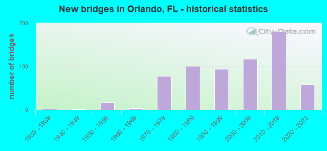
- New bridges - historical statistics
- 11920-1929
- 21930-1939
- 11940-1949
- 171950-1959
- 41960-1969
- 781970-1979
- 1011980-1989
- 941990-1999
- 1182000-2009
- 1802010-2019
- 582020-2022

- Reconstructed bridges - Historical Statistics
- 11950-1959
- 01960-1969
- 11970-1979
- 11980-1989
- 101990-1999
- 432000-2009
- 242010-2019
- 32020-2022


- Bridge Condition - Deck
- 35.5%Very good
- 56.2%Good
- 6.0%Satisfactory
- 2.0%Fair
- 0.3%Poor

- Bridge Condition - Superstructure
- 36.8%Very good
- 58.5%Good
- 2.0%Satisfactory
- 2.3%Fair
- 0.3%Poor

- Bridge Condition - Substructure
- 0.7%Excellent
- 41.8%Very good
- 55.2%Good
- 2.3%Satisfactory

- Bridge Condition - Channel
- 10.1%Excellent
- 27.8%Very good
- 54.4%Good
- 7.6%Satisfactory

- Bridge Condition - Culverts
- 20.0%Very good
- 35.0%Good
- 45.0%Satisfactory
Find on map >> Show street view
Structure Number: 750557, Location: SR-417 NB-University Blvd (Lat: 28.597369, Lng: -81.249614), Route carried "under" structure: Alternate County highway 4364, Year Built: 2002, Structure Length: 0. m, Average Daily Traffic: 39,000 (year 2020), Truck Traffic: 4%, Features Intersected: University Blvd., Facility Carried by Structure: NB C-D Road Ramp
Minimum Vertical Clearance: 6.10m (20.01ft), Kilometerpoint: 3.587, Lanes on structure: 2, Lanes under structure: 7, Material/Design: Steel, Design/Construction: Stringer/Multi-beam, Length of Maximum Span: 41.3m (135.5ft)
Find on map >> Show street view
Structure Number: 75056, Location: SR-50 WB over SR-436 (Lat: 28.557103, Lng: -81.310928), Route carried "under" structure: State highway 436, Year Built: 2010, Structure Length: 0. m, Average Daily Traffic: 61,500 (year 2020), Truck Traffic: 5%, Features Intersected: SR-436, Facility Carried by Structure: SR-50 WB
Minimum Vertical Clearance: 5.27m (17.29ft), Kilometerpoint: 11.763, Lanes on structure: 3, Lanes under structure: 12, Material/Design: Steel continuous, Design/Construction: Box Beam or Girders - Single/Spread, Length of Maximum Span: 78.7m (258.2ft)
Find on map >> Show street view
Structure Number: 750561, Location: SR-50 EB over SR-436 (Lat: 28.556928, Lng: -81.310786), Route carried "under" structure: State highway 436, Year Built: 2010, Structure Length: 0. m, Average Daily Traffic: 61,500 (year 2020), Truck Traffic: 5%, Features Intersected: SR-436, Facility Carried by Structure: SR-50 EB
Minimum Vertical Clearance: 5.18m (16.99ft), Kilometerpoint: 11.763, Lanes on structure: 3, Lanes under structure: 10, Material/Design: Steel continuous, Design/Construction: Box Beam or Girders - Single/Spread, Length of Maximum Span: 75.1m (246.4ft)
Find on map >> Show street view
Structure Number: 750563, Location: SR-434 SB - US-441 (Lat: 28.599153, Lng: -81.417175), Route carried "under" structure: US 500, Year Built: 2013, Structure Length: 0. m, Average Daily Traffic: 50,000 (year 2013), Truck Traffic: 4%, Features Intersected: US-441, Facility Carried by Structure: SR-434 SB
Minimum Vertical Clearance: 8.11m (26.61ft), Kilometerpoint: 5.488, Lanes on structure: 3, Lanes under structure: 7, Material/Design: Steel continuous, Design/Construction: Stringer/Multi-beam, Length of Maximum Span: 82.3m (270.0ft)
Find on map >> Show street view
Structure Number: 750563, Location: SR-434 SB - US-441 (Lat: 28.599153, Lng: -81.417175), Route carried "under" structure: State highway 423, Year Built: 2013, Structure Length: 0. m, Average Daily Traffic: 27,000 (year 2018), Truck Traffic: 7%, Features Intersected: US-441, Facility Carried by Structure: SR-434 SB
Minimum Vertical Clearance: 4.94m (16.21ft), Kilometerpoint: 10.358, Lanes on structure: 3, Lanes under structure: 2, Material/Design: Steel continuous, Design/Construction: Stringer/Multi-beam, Length of Maximum Span: 82.3m (270.0ft)
Find on map >> Show street view
Structure Number: 750564, Location: SR-434 NB - US-441 (Lat: 28.598511, Lng: -81.417100), Route carried "under" structure: US 500, Year Built: 2013, Structure Length: 0. m, Average Daily Traffic: 50,000 (year 2013), Truck Traffic: 4%, Features Intersected: US-441, Facility Carried by Structure: SR-434 NB
Minimum Vertical Clearance: 7.83m (25.69ft), Kilometerpoint: 0.000, Lanes on structure: 3, Lanes under structure: 7, Material/Design: Steel continuous, Design/Construction: Stringer/Multi-beam, Length of Maximum Span: 75.0m (246.1ft)
Find on map >> Show street view
Structure Number: 750564, Location: SR-434 NB - US-441 (Lat: 28.598511, Lng: -81.417100), Route carried "under" structure: State highway 423, Year Built: 2013, Structure Length: 0. m, Average Daily Traffic: 24,250 (year 2020), Truck Traffic: 7%, Features Intersected: US-441, Facility Carried by Structure: SR-434 NB
Minimum Vertical Clearance: 5.76m (18.90ft), Kilometerpoint: 10.358, Lanes on structure: 3, Lanes under structure: 2, Material/Design: Steel continuous, Design/Construction: Stringer/Multi-beam, Length of Maximum Span: 75.0m (246.1ft)
Find on map >> Show street view
Structure Number: 750569, Location: SR-408 EB Ramp C over I-4 (Lat: 28.534675, Lng: -81.384208), Route carried "under" structure: Alternate City street , Year Built: 2008, Structure Length: 0. m, Average Daily Traffic: 11,500 (year 2022), Truck Traffic: 6%, Features Intersected: I-4, Facility Carried by Structure: SR-408 EB Ramp C
Minimum Vertical Clearance: 10.82m (35.50ft), Kilometerpoint: 2.340, Lanes on structure: 1, Lanes under structure: 4, Material/Design: Steel continuous, Design/Construction: Box Beam or Girders - Single/Spread, Length of Maximum Span: 70.8m (232.3ft)
Find on map >> Show street view
Structure Number: 750569, Location: SR-408 EB Ramp C over I-4 (Lat: 28.534675, Lng: -81.384208), Route carried "under" structure: Interstate 4, Year Built: 2008, Structure Length: 0. m, Average Daily Traffic: 149,000 (year 2022), Truck Traffic: 6%, Features Intersected: I-4
Minimum Vertical Clearance: 5.49m (18.01ft), Kilometerpoint: 27.401, Lanes on structure: 1, Lanes under structure: 8, Material/Design: Steel continuous, Design/Construction: Box Beam or Girders - Single/Spread, Length of Maximum Span: 70.8m (232.3ft)
Find on map >> Show street view
Structure Number: 750569, Location: SR-408 EB Ramp C over I-4 (Lat: 28.534675, Lng: -81.384208), Route carried "under" structure: Ramp State highway 408, Year Built: 2008, Structure Length: 0. m, Average Daily Traffic: 5,000 (year 2022), Truck Traffic: 5%, Features Intersected: I-4
Minimum Vertical Clearance: 5.46m (17.91ft), Kilometerpoint: 0.628, Lanes on structure: 1, Lanes under structure: 1, Toll: On toll road, Material/Design: Steel continuous, Design/Construction: Box Beam or Girders - Single/Spread, Length of Maximum Span: 70.8m (232.3ft)
Find on map >> Show street view
Structure Number: 750569, Location: SR-408 EB Ramp C over I-4 (Lat: 28.534675, Lng: -81.384208), Route carried "under" structure: City street , Year Built: 2008, Structure Length: 0. m, Average Daily Traffic: 30 (year 2022), Truck Traffic: 1%, Features Intersected: I-4, Facility Carried by Structure: SR-408 EB Ramp C
Minimum Vertical Clearance: 7.38m (24.21ft), Kilometerpoint: 0.000, Lanes on structure: 1, Lanes under structure: 2, Material/Design: Steel continuous, Design/Construction: Box Beam or Girders - Single/Spread, Length of Maximum Span: 70.8m (232.3ft)
Find on map >> Show street view
Structure Number: 750569, Location: SR-408 EB Ramp C over I-4 (Lat: 28.534675, Lng: -81.384208), Route carried "under" structure: Ramp State highway 408, Year Built: 2008, Structure Length: 0. m, Average Daily Traffic: 7,000 (year 2022), Truck Traffic: 4%, Features Intersected: I-4
Minimum Vertical Clearance: 5.91m (19.39ft), Kilometerpoint: 0.121, Lanes on structure: 1, Lanes under structure: 1, Toll: On toll road, Material/Design: Steel continuous, Design/Construction: Box Beam or Girders - Single/Spread, Length of Maximum Span: 70.8m (232.3ft)
Find on map >> Show street view
Structure Number: 750569, Location: SR-408 EB Ramp C over I-4 (Lat: 28.534675, Lng: -81.384208), Route carried "under" structure: Ramp State highway 408, Year Built: 2008, Structure Length: 0. m, Average Daily Traffic: 5,000 (year 2022), Truck Traffic: 5%, Features Intersected: I-4
Minimum Vertical Clearance: 6.40m (21.00ft), Kilometerpoint: 0.159, Lanes on structure: 1, Lanes under structure: 1, Toll: On toll road, Material/Design: Steel continuous, Design/Construction: Box Beam or Girders - Single/Spread, Length of Maximum Span: 70.8m (232.3ft)
Find on map >> Show street view
Structure Number: 75057, Location: 0.5 Mi East of I-4 (Lat: 28.536583, Lng: -81.379222), Route carried "under" structure: City street , Year Built: 2008, Structure Length: 0. m, Average Daily Traffic: 1,500 (year 2020), Truck Traffic: 1%, Features Intersected: I-4 Ramp-D, Facility Carried by Structure: SR-408WB to I-4EB
Minimum Vertical Clearance: 8.41m (27.59ft), Kilometerpoint: 0.000, Lanes on structure: 2, Lanes under structure: 3, Material/Design: Steel continuous, Design/Construction: Box Beam or Girders - Single/Spread, Length of Maximum Span: 67.1m (220.1ft)
Find on map >> Show street view
Structure Number: 75057, Location: 0.5 Mi East of I-4 (Lat: 28.536583, Lng: -81.379222), Route carried "under" structure: City street , Year Built: 2008, Structure Length: 0. m, Average Daily Traffic: 500 (year 2020), Truck Traffic: 1%, Features Intersected: I-4 Ramp-D, Facility Carried by Structure: SR-408WB to I-4EB
Minimum Vertical Clearance: 8.14m (26.71ft), Kilometerpoint: 0.000, Lanes on structure: 2, Lanes under structure: 3, Material/Design: Steel continuous, Design/Construction: Box Beam or Girders - Single/Spread, Length of Maximum Span: 67.1m (220.1ft)
Find on map >> Show street view
Structure Number: 75057, Location: 0.5 Mi East of I-4 (Lat: 28.536583, Lng: -81.379222), Route carried "under" structure: City street , Year Built: 2008, Structure Length: 0. m, Average Daily Traffic: 500 (year 2020), Truck Traffic: 1%, Features Intersected: I-4 Ramp-D, Facility Carried by Structure: SR-408WB to I-4EB
Minimum Vertical Clearance: 10.67m (35.01ft), Kilometerpoint: 0.000, Lanes on structure: 2, Lanes under structure: 3, Material/Design: Steel continuous, Design/Construction: Box Beam or Girders - Single/Spread, Length of Maximum Span: 67.1m (220.1ft)
Find on map >> Show street view
Structure Number: 75057, Location: 0.5 Mi East of I-4 (Lat: 28.536583, Lng: -81.379222), Route carried "under" structure: City street , Year Built: 2008, Structure Length: 0. m, Average Daily Traffic: 500 (year 2020), Truck Traffic: 1%, Features Intersected: I-4 Ramp-D, Facility Carried by Structure: SR-408WB to I-4EB
Minimum Vertical Clearance: 11.64m (38.19ft), Kilometerpoint: 0.000, Lanes on structure: 2, Lanes under structure: 1, Material/Design: Steel continuous, Design/Construction: Box Beam or Girders - Single/Spread, Length of Maximum Span: 67.1m (220.1ft)
Find on map >> Show street view
Structure Number: 75057, Location: 0.5 Mi East of I-4 (Lat: 28.536583, Lng: -81.379222), Route carried "under" structure: City street , Year Built: 2008, Structure Length: 0. m, Average Daily Traffic: 500 (year 2020), Truck Traffic: 1%, Features Intersected: I-4 Ramp-D, Facility Carried by Structure: SR-408WB to I-4EB
Minimum Vertical Clearance: 8.11m (26.61ft), Kilometerpoint: 0.000, Lanes on structure: 2, Lanes under structure: 2, Material/Design: Steel continuous, Design/Construction: Box Beam or Girders - Single/Spread, Length of Maximum Span: 67.1m (220.1ft)
Find on map >> Show street view
Structure Number: 750571, Location: 0.1 Mi East of I-4 (Lat: 28.536347, Lng: -81.380717), Route carried "under" structure: City street 400, Year Built: 2008, Structure Length: 0. m, Average Daily Traffic: 500 (year 2020), Truck Traffic: 1%, Features Intersected: I-4 Ramp D-1, Facility Carried by Structure: SR-408WB to I-4EB
Minimum Vertical Clearance: 13.50m (44.29ft), Kilometerpoint: 1.922, Lanes on structure: 1, Lanes under structure: 4, Material/Design: Steel continuous, Design/Construction: Box Beam or Girders - Single/Spread, Length of Maximum Span: 70.1m (230.0ft)
Find on map >> Show street view
Structure Number: 750571, Location: 0.1 Mi East of I-4 (Lat: 28.536347, Lng: -81.380717), Route carried "under" structure: City street 400, Year Built: 2008, Structure Length: 0. m, Average Daily Traffic: 500 (year 2020), Truck Traffic: 1%, Features Intersected: I-4 Ramp D-1, Facility Carried by Structure: SR-408WB to I-4EB
Minimum Vertical Clearance: 14.84m (48.69ft), Kilometerpoint: 0.080, Lanes on structure: 1, Lanes under structure: 2, Material/Design: Steel continuous, Design/Construction: Box Beam or Girders - Single/Spread, Length of Maximum Span: 70.1m (230.0ft)
Find on map >> Show street view
Structure Number: 750571, Location: 0.1 Mi East of I-4 (Lat: 28.536347, Lng: -81.380717), Route carried "under" structure: City street , Year Built: 2008, Structure Length: 0. m, Average Daily Traffic: 500 (year 2020), Truck Traffic: 1%, Features Intersected: I-4 Ramp D-1, Facility Carried by Structure: SR-408WB to I-4EB
Minimum Vertical Clearance: 4.91m (16.11ft), Kilometerpoint: 1.934, Lanes on structure: 1, Lanes under structure: 5, Material/Design: Steel continuous, Design/Construction: Box Beam or Girders - Single/Spread, Length of Maximum Span: 70.1m (230.0ft)
Find on map >> Show street view
Structure Number: 750571, Location: 0.1 Mi East of I-4 (Lat: 28.536347, Lng: -81.380717), Route carried "under" structure: City street , Year Built: 2008, Structure Length: 0. m, Average Daily Traffic: 50 (year 2020), Truck Traffic: 1%, Features Intersected: I-4 Ramp D-1, Facility Carried by Structure: SR-408WB to I-4EB
Minimum Vertical Clearance: 13.62m (44.69ft), Kilometerpoint: 0.000, Lanes on structure: 1, Lanes under structure: 2, Material/Design: Steel continuous, Design/Construction: Box Beam or Girders - Single/Spread, Length of Maximum Span: 70.1m (230.0ft)
Find on map >> Show street view
Structure Number: 750573, Location: I-4 EB Ramp (Lat: 28.536617, Lng: -81.382081), Route carried "under" structure: Ramp State highway , Year Built: 2008, Structure Length: 0. m, Average Daily Traffic: 10,000 (year 2020), Truck Traffic: 5%, Features Intersected: Anderson St. Overpass, Facility Carried by Structure: I-4 EB Ramp
Minimum Vertical Clearance: 7.16m (23.49ft), Kilometerpoint: 0.002, Lanes on structure: 1, Lanes under structure: 2, Material/Design: Steel, Design/Construction: Stringer/Multi-beam, Length of Maximum Span: 49.5m (162.4ft)
Find on map >> Show street view
Structure Number: 750574, Location: Ramp F2 over South St. (Lat: 28.538056, Lng: -81.382778), Route carried "under" structure: Ramp City street , Year Built: 2007, Structure Length: 0. m, Average Daily Traffic: 10,500 (year 2020), Truck Traffic: 5%, Features Intersected: South St & Ramp G, Facility Carried by Structure: I-4 Ramp
Minimum Vertical Clearance: 4.97m (16.31ft), Kilometerpoint: 0.032, Lanes on structure: 2, Lanes under structure: 2, Material/Design: Steel continuous, Design/Construction: Stringer/Multi-beam, Length of Maximum Span: 57.9m (190.0ft)
Find on map >> Show street view
Structure Number: 750574, Location: Ramp F2 over South St. (Lat: 28.538056, Lng: -81.382778), Route carried "under" structure: City street , Year Built: 2007, Structure Length: 0. m, Average Daily Traffic: 10,000 (year 2020), Truck Traffic: 5%, Features Intersected: South St & Ramp G, Facility Carried by Structure: I-4 Ramp
Minimum Vertical Clearance: 5.12m (16.80ft), Kilometerpoint: 1.733, Lanes on structure: 2, Lanes under structure: 3, Material/Design: Steel continuous, Design/Construction: Stringer/Multi-beam, Length of Maximum Span: 57.9m (190.0ft)
Find on map >> Show street view
Structure Number: 750579, Location: 0.7 Mi W Of Semoran Blvd. (Lat: 28.539139, Lng: -81.322194), Route carried "under" structure: Ramp State highway 408, Year Built: 2008, Structure Length: 0. m, Average Daily Traffic: 11,000 (year 2020), Truck Traffic: 6%, Features Intersected: SR-408 EB Exit Ramp, Facility Carried by Structure: Lake Underhill Dr.
Minimum Vertical Clearance: 5.52m (18.11ft), Kilometerpoint: 0.203, Lanes on structure: 1, Lanes under structure: 1, Toll: On toll road, Material/Design: Steel, Design/Construction: Stringer/Multi-beam, Length of Maximum Span: 32.3m (106.0ft)
Find on map >> Show street view
Structure Number: 75058, Location: 4.8 Mi East of US-17 (Lat: 28.539547, Lng: -81.319289), Route carried "under" structure: City street , Year Built: 2009, Structure Length: 0. m, Average Daily Traffic: 2,179 (year 2020), Truck Traffic: 1%, Features Intersected: Andes Avenue, Facility Carried by Structure: SR-408 EB Toll Plz
Minimum Vertical Clearance: 4.79m (15.72ft), Kilometerpoint: 0.016, Lanes on structure: 5, Lanes under structure: 3, Material/Design: Prestressed concrete, Design/Construction: Stringer/Multi-beam, Length of Maximum Span: 29.9m (98.1ft)
Find on map >> Show street view
Structure Number: 750581, Location: SR-408 - SR-436 (Lat: 28.539442, Lng: -81.310631), Route carried "under" structure: State highway 436, Year Built: 2007, Structure Length: 0. m, Average Daily Traffic: 55,500 (year 2020), Truck Traffic: 9%, Features Intersected: Semoran Blvd., Facility Carried by Structure: SR-408
Minimum Vertical Clearance: 6.16m (20.21ft), Kilometerpoint: 9.796, Lanes on structure: 10, Lanes under structure: 8, Material/Design: Steel, Design/Construction: Stringer/Multi-beam, Length of Maximum Span: 47.9m (157.2ft)
Find on map >> Show street view
Structure Number: 750589, Location: Conway Rd Ramp at SR-408 (Lat: 28.538422, Lng: -81.331422), Route carried "under" structure: State highway 408, Year Built: 2010, Structure Length: 0. m, Average Daily Traffic: 143,500 (year 2020), Truck Traffic: 3%, Features Intersected: SR-408, Facility Carried by Structure: Conway Rd Ramp
Minimum Vertical Clearance: 6.37m (20.90ft), Kilometerpoint: 13.424, Lanes on structure: 1, Lanes under structure: 10, Toll: On toll road, Material/Design: Steel continuous, Design/Construction: Box Beam or Girders - Single/Spread, Length of Maximum Span: 48.8m (160.1ft)
Find on map >> Show street view
Structure Number: 75059, Location: 0.6 MI E OF FL TURNPIKE (Lat: 28.485722, Lng: -81.441167), Route carried "under" structure: City street , Year Built: 2017, Structure Length: 0. m, Average Daily Traffic: 25,000 (year 2021), Truck Traffic: 4%, Features Intersected: Radebaugh Way, Facility Carried by Structure: I-4
Minimum Vertical Clearance: 5.09m (16.70ft), Kilometerpoint: 0.135, Lanes on structure: 7, Lanes under structure: 3, Material/Design: Prestressed concrete, Design/Construction: Stringer/Multi-beam, Length of Maximum Span: 28.0m (91.9ft)
Find on map >> Show street view
Structure Number: 750591, Location: 0.6MI E OF FL Turnpike (Lat: 28.485250, Lng: -81.440667), Route carried "under" structure: County highway , Year Built: 2018, Structure Length: 0. m, Average Daily Traffic: 25,000 (year 2021), Truck Traffic: 4%, Features Intersected: Radebaugh Way, Facility Carried by Structure: I-4
Minimum Vertical Clearance: 5.06m (16.60ft), Kilometerpoint: 0.135, Lanes on structure: 7, Lanes under structure: 3, Material/Design: Prestressed concrete, Design/Construction: Stringer/Multi-beam, Length of Maximum Span: 28.0m (91.9ft)
Find on map >> Show street view
Structure Number: 750592, Location: 0.3mi E of I-4 Exit (Lat: 28.480444, Lng: -81.447722), Route carried "under" structure: Interstate 4, Year Built: 2018, Structure Length: 0. m, Average Daily Traffic: 164,000 (year 2021), Truck Traffic: 6%, Features Intersected: I-4, Facility Carried by Structure: Turnpike Ramp D1
Minimum Vertical Clearance: 5.21m (17.09ft), Kilometerpoint: 17.814, Lanes on structure: 3, Lanes under structure: 12, Material/Design: Prestressed concrete, Design/Construction: Stringer/Multi-beam, Length of Maximum Span: 45.0m (147.6ft)
Find on map >> Show street view
Structure Number: 750593, Location: 0.4mi E of Universal Blvd (Lat: 28.470333, Lng: -81.459667), Route carried "under" structure: Interstate 4, Year Built: 2017, Structure Length: 0. m, Average Daily Traffic: 37,200 (year 2021), Truck Traffic: 7%, Features Intersected: I-4 (SR-400) WB
Minimum Vertical Clearance: 6.28m (20.60ft), Kilometerpoint: 15.844, Lanes on structure: 4, Lanes under structure: 13, Material/Design: Steel continuous, Design/Construction: Stringer/Multi-beam, Length of Maximum Span: 68.7m (225.4ft)
Find on map >> Show street view
Structure Number: 750594, Location: 0.8mi W of Fl Turnpike (Lat: 28.471306, Lng: -81.458667), Route carried "under" structure: Interstate 4, Year Built: 2016, Structure Length: 0. m, Average Daily Traffic: 372,000 (year 2021), Truck Traffic: 7%, Features Intersected: I-4 (SR-400)
Minimum Vertical Clearance: 5.36m (17.59ft), Kilometerpoint: 16.076, Lanes on structure: 4, Lanes under structure: 13, Material/Design: Steel continuous, Design/Construction: Stringer/Multi-beam, Length of Maximum Span: 70.1m (230.0ft)
Find on map >> Show street view
Structure Number: 750595, Location: 0.16mi W of SR 435 (Lat: 28.466444, Lng: -81.462833), Route carried "under" structure: Ramp Interstate 4, Year Built: 2018, Structure Length: 0. m, Average Daily Traffic: 3,000 (year 2021), Truck Traffic: 1%, Features Intersected: I-4 EB to SR 435
Minimum Vertical Clearance: 5.18m (16.99ft), Kilometerpoint: 15.611, Lanes on structure: 2, Lanes under structure: 2, Material/Design: Prestressed concrete continuous, Design/Construction: Stringer/Multi-beam, Length of Maximum Span: 47.2m (154.9ft)
Find on map >> Show street view
Structure Number: 750596, Location: At WB SR-435(Kirkman Rd) (Lat: 28.472667, Lng: -81.458806), Route carried "under" structure: State highway 435, Year Built: 2017, Structure Length: 0. m, Average Daily Traffic: 65,400 (year 2021), Truck Traffic: 4%, Features Intersected: SR 435 (Kirkman Rd), Facility Carried by Structure: I-4 WB to Kirkman
Minimum Vertical Clearance: 5.55m (18.21ft), Kilometerpoint: 2.453, Lanes on structure: 2, Lanes under structure: 4, Material/Design: Steel, Design/Construction: Stringer/Multi-beam, Length of Maximum Span: 49.3m (161.7ft)
Find on map >> Show street view
Structure Number: 750597, Location: 0.3mi E of Universal Blvd (Lat: 28.467333, Lng: -81.459250), Route carried "under" structure: State highway 435, Year Built: 2019, Structure Length: 0. m, Average Daily Traffic: 65,400 (year 2021), Truck Traffic: 4%, Features Intersected: Kirkman Road SB, Facility Carried by Structure: Ramp D
Minimum Vertical Clearance: 5.12m (16.80ft), Kilometerpoint: 2.253, Lanes on structure: 2, Lanes under structure: 4, Material/Design: Steel, Design/Construction: Stringer/Multi-beam, Length of Maximum Span: 41.5m (136.2ft)
Find on map >> Show street view
Structure Number: 750603, Location: I-4 SR 91 TPK INTERCHANGE (Lat: 28.478939, Lng: -81.449219), Route carried "under" structure: Interstate 4, Year Built: 2002, Structure Length: 0. m, Average Daily Traffic: 166,500 (year 2020), Truck Traffic: 8%, Features Intersected: I-4 SR 400, Facility Carried by Structure: SR 91 TPK NB 259.8
Minimum Vertical Clearance: 5.21m (17.09ft), Kilometerpoint: 17.505, Lanes on structure: 5, Lanes under structure: 8, Material/Design: Prestressed concrete, Design/Construction: Stringer/Multi-beam, Length of Maximum Span: 45.7m (149.9ft)
Find on map >> Show street view
Structure Number: 75061, Location: I-4 SR 91 TPK INTERSECT (Lat: 28.478733, Lng: -81.449467), Route carried "under" structure: Interstate 4, Year Built: 2003, Structure Length: 0. m, Average Daily Traffic: 166,500 (year 2020), Truck Traffic: 8%, Features Intersected: I-4 SR 400, Facility Carried by Structure: SR 91 TPK SB 259.8
Minimum Vertical Clearance: 4.91m (16.11ft), Kilometerpoint: 17.535, Lanes on structure: 5, Lanes under structure: 8, Material/Design: Prestressed concrete, Design/Construction: Stringer/Multi-beam, Length of Maximum Span: 45.7m (149.9ft)
Find on map >> Show street view
Structure Number: 750611, Location: SR91 RMP A2 FLYOVR SR417 (Lat: 28.366861, Lng: -81.389439), Route carried "under" structure: City street , Year Built: 2020, Structure Length: 0. m, Average Daily Traffic: 17,600 (year 2020), Truck Traffic: 2%, Features Intersected: SR 417, Facility Carried by Structure: SR91 RMP A2 250.84
Minimum Vertical Clearance: 5.28m (17.32ft), Kilometerpoint: 3.541, Lanes on structure: 2, Lanes under structure: 4, Material/Design: Steel continuous, Design/Construction: Box Beam or Girders - Multiple, Length of Maximum Span: 82.4m (270.3ft)
Find on map >> Show street view
Structure Number: 750611, Location: SR91 RMP A2 FLYOVR SR417 (Lat: 28.366861, Lng: -81.389439), Route carried "under" structure: State highway 417, Year Built: 2020, Structure Length: 0. m, Average Daily Traffic: 60,700 (year 2017), Truck Traffic: 6%, Features Intersected: SR 417, Facility Carried by Structure: SR91 RMP A2 250.84
Minimum Vertical Clearance: 5.94m (19.49ft), Kilometerpoint: 19.360, Lanes on structure: 2, Lanes under structure: 5, Toll: On toll road, Material/Design: Steel continuous, Design/Construction: Box Beam or Girders - Multiple, Length of Maximum Span: 82.4m (270.3ft)
Find on map >> Show street view
Structure Number: 750611, Location: SR91 RMP A2 FLYOVR SR417 (Lat: 28.366861, Lng: -81.389439), Route carried "under" structure: State highway 91, Year Built: 2020, Structure Length: 0. m, Average Daily Traffic: 72,000 (year 2020), Truck Traffic: 13%, Features Intersected: SR 417
Minimum Vertical Clearance: 13.75m (45.11ft), Kilometerpoint: 2.194, Lanes on structure: 2, Lanes under structure: 9, Toll: On toll road, Material/Design: Steel continuous, Design/Construction: Box Beam or Girders - Multiple, Length of Maximum Span: 82.4m (270.3ft)
Find on map >> Show street view
Structure Number: 750613, Location: 0.6MI N OF TURKY LK REST (Lat: 28.520953, Lng: -81.507794), Route carried "under" structure: County highway , Year Built: 2006, Structure Length: 0. m, Average Daily Traffic: 14,900 (year 2000), Truck Traffic: 4%, Features Intersected: APOPKA VINELAND RD, Facility Carried by Structure: SR 91 NB/SB 264.6
Minimum Vertical Clearance: 4.98m (16.34ft), Kilometerpoint: 24.232, Lanes on structure: 8, Lanes under structure: 4, Material/Design: Prestressed concrete, Design/Construction: Stringer/Multi-beam, Length of Maximum Span: 17.7m (58.1ft)
Find on map >> Show street view
Structure Number: 750624, Location: 0.3 MI SOUTH OF I-4 (Lat: 28.474603, Lng: -81.446236), Route carried "under" structure: State highway 91, Year Built: 2007, Structure Length: 0. m, Average Daily Traffic: 98,100 (year 2020), Truck Traffic: 21%, Features Intersected: SR 91 TPK, Facility Carried by Structure: RAMP A 259.5
Minimum Vertical Clearance: 5.36m (17.59ft), Kilometerpoint: 16.174, Lanes on structure: 2, Lanes under structure: 8, Toll: On toll road, Material/Design: Prestressed concrete, Design/Construction: Stringer/Multi-beam, Length of Maximum Span: 31.6m (103.7ft)
Find on map >> Show street view
Structure Number: 750626, Location: 0.3 MILES S OF SR 528 (Lat: 28.430197, Lng: -81.404703), Route carried "under" structure: State highway 91, Year Built: 2007, Structure Length: 0. m, Average Daily Traffic: 64,000 (year 2020), Truck Traffic: 5%, Features Intersected: US 441
Minimum Vertical Clearance: 4.89m (16.04ft), Kilometerpoint: 9.727, Lanes on structure: 9, Lanes under structure: 7, Material/Design: Steel, Design/Construction: Stringer/Multi-beam, Length of Maximum Span: 57.2m (187.7ft)
Find on map >> Show street view
Structure Number: 750628, Location: SR408 WB RAMP TO TPK SB (Lat: 28.534333, Lng: -81.527928), Route carried "under" structure: State highway 91, Year Built: 2006, Structure Length: 0. m, Average Daily Traffic: 97,000 (year 2020), Truck Traffic: 21%, Features Intersected: SR 91 TPK, Facility Carried by Structure: SR408 RAMP C 266.1
Minimum Vertical Clearance: 5.03m (16.50ft), Kilometerpoint: 26.665, Lanes on structure: 1, Lanes under structure: 8, Toll: On toll road, Material/Design: Steel continuous, Design/Construction: Stringer/Multi-beam, Length of Maximum Span: 66.1m (216.9ft)
Find on map >> Show street view
Structure Number: 750628, Location: SR408 WB RAMP TO TPK SB (Lat: 28.534333, Lng: -81.527928), Route carried "under" structure: Ramp State highway 91, Year Built: 2006, Structure Length: 0. m, Average Daily Traffic: 107,000 (year 2016), Truck Traffic: 17%, Features Intersected: SR 91 TPK, Facility Carried by Structure: SR408 RAMP C 266.1
Minimum Vertical Clearance: 5.00m (16.40ft), Kilometerpoint: 26.715, Lanes on structure: 1, Lanes under structure: 2, Toll: On toll road, Material/Design: Steel continuous, Design/Construction: Stringer/Multi-beam, Length of Maximum Span: 66.1m (216.9ft)
Find on map >> Show street view
Structure Number: 750638, Location: 1.8MI N OF OSCEOLA PKWY (Lat: 28.365806, Lng: -81.387861), Route carried "under" structure: County highway , Year Built: 2015, Structure Length: 0. m, Average Daily Traffic: 2,328 (year 2014), Truck Traffic: 5%, Features Intersected: TOWN CENTER BLVD, Facility Carried by Structure: SR91 NB RAMP 250.7
Minimum Vertical Clearance: 5.08m (16.67ft), Kilometerpoint: 5.148, Lanes on structure: 1, Lanes under structure: 4, Material/Design: Prestressed concrete, Design/Construction: Stringer/Multi-beam, Length of Maximum Span: 43.8m (143.7ft)
Find on map >> Show street view
Structure Number: 750639, Location: 1.9MI N OF OSCEOLA PKWY (Lat: 28.366519, Lng: -81.387236), Route carried "under" structure: ServiceOther road , Year Built: 2015, Structure Length: 0. m, Average Daily Traffic: 2 (year 2015), Truck Traffic: 50%, Features Intersected: CELL TOWER ACCESS RD, Facility Carried by Structure: SR91 NB RAMP 250.8
Minimum Vertical Clearance: 8.08m (26.51ft), Kilometerpoint: 0.000, Lanes on structure: 1, Lanes under structure: 2, Material/Design: Prestressed concrete, Design/Construction: Stringer/Multi-beam, Length of Maximum Span: 20.1m (65.9ft)
Find on map >> Show street view
Structure Number: 75064, Location: 0.3 MI S OF I-4 (Lat: 28.474317, Lng: -81.446042), Route carried "under" structure: State highway 91, Year Built: 2014, Structure Length: 0. m, Average Daily Traffic: 98,100 (year 2020), Truck Traffic: 21%, Features Intersected: SR 91 TPK, Facility Carried by Structure: RAMP C 259.5
Minimum Vertical Clearance: 5.39m (17.68ft), Kilometerpoint: 16.139, Lanes on structure: 2, Lanes under structure: 10, Toll: On toll road, Material/Design: Prestressed concrete, Design/Construction: Stringer/Multi-beam, Length of Maximum Span: 31.8m (104.3ft)
Find on map >> Show street view
Structure Number: 750643, Location: 2.6MI N/O SR-417 (Lat: 28.406656, Lng: -81.391311), Route carried "under" structure: County highway , Year Built: 2019, Structure Length: 0. m, Average Daily Traffic: 1,300 (year 2014), Truck Traffic: 5%, Features Intersected: RR & CENTRAL FL PKWY, Facility Carried by Structure: SR 91 NS 253.6
Minimum Vertical Clearance: 7.16m (23.49ft), Kilometerpoint: 0.000, Lanes on structure: 8, Lanes under structure: 2, Material/Design: Prestressed concrete, Design/Construction: Stringer/Multi-beam, Length of Maximum Span: 30.5m (100.1ft)
Find on map >> Show street view
Structure Number: 750644, Location: SR91 RMP C2 FLYOVR SR417 (Lat: 28.368717, Lng: -81.389128), Route carried "under" structure: State highway 417, Year Built: 2020, Structure Length: 0. m, Average Daily Traffic: 60,700 (year 2017), Truck Traffic: 6%, Features Intersected: SR 417, Facility Carried by Structure: SR 91 RMP C2 250.9
Minimum Vertical Clearance: 5.26m (17.26ft), Kilometerpoint: 19.634, Lanes on structure: 2, Lanes under structure: 4, Toll: On toll road, Material/Design: Steel continuous, Design/Construction: Box Beam or Girders - Single/Spread, Length of Maximum Span: 83.9m (275.3ft)
Find on map >> Show street view
Structure Number: 750644, Location: SR91 RMP C2 FLYOVR SR417 (Lat: 28.368717, Lng: -81.389128), Route carried "under" structure: Ramp State highway 417, Year Built: 2020, Structure Length: 0. m, Average Daily Traffic: 900 (year 2015), Truck Traffic: 13%, Features Intersected: SR 417, Facility Carried by Structure: SR 91 RMP C2 250.9
Minimum Vertical Clearance: 6.34m (20.80ft), Kilometerpoint: 19.634, Lanes on structure: 2, Lanes under structure: 1, Toll: On toll road, Material/Design: Steel continuous, Design/Construction: Box Beam or Girders - Single/Spread, Length of Maximum Span: 83.9m (275.3ft)
Find on map >> Show street view
Structure Number: 750644, Location: SR91 RMP C2 FLYOVR SR417 (Lat: 28.368717, Lng: -81.389128), Route carried "under" structure: State highway 91, Year Built: 2020, Structure Length: 0. m, Average Daily Traffic: 72,000 (year 2020), Truck Traffic: 13%, Features Intersected: SR 417
Minimum Vertical Clearance: 5.52m (18.11ft), Kilometerpoint: 4.039, Lanes on structure: 2, Lanes under structure: 9, Toll: On toll road, Material/Design: Steel continuous, Design/Construction: Box Beam or Girders - Single/Spread, Length of Maximum Span: 83.9m (275.3ft)
Find on map >> Show street view
Structure Number: 750701, Location: SR-408 Ramp - Summerlin (Lat: 28.537461, Lng: -81.368361), Route carried "under" structure: Ramp City street , Year Built: 2007, Structure Length: 0. m, Average Daily Traffic: 53,760 (year 2017), Truck Traffic: 13%, Features Intersected: Summerlin, Facility Carried by Structure: SR-408 WB
Minimum Vertical Clearance: 5.03m (16.50ft), Kilometerpoint: 0.000, Lanes on structure: 2, Lanes under structure: 3, Material/Design: Prestressed concrete, Design/Construction: Stringer/Multi-beam, Length of Maximum Span: 31.1m (102.0ft)
Find on map >> Show street view
Structure Number: 750703, Location: SR-414 over CR-435 (Lat: 28.642700, Lng: -81.503131), Route carried "under" structure: Business City street 435, Year Built: 2009, Structure Length: 0. m, Average Daily Traffic: 9,200 (year 2020), Truck Traffic: 6%, Features Intersected: CR-435, Facility Carried by Structure: SR-414
Minimum Vertical Clearance: 5.03m (16.50ft), Kilometerpoint: 12.234, Lanes on structure: 8, Lanes under structure: 2, Material/Design: Steel, Design/Construction: Stringer/Multi-beam, Length of Maximum Span: 50.5m (165.7ft)
Find on map >> Show street view
Structure Number: 750705, Location: SR-414 over Keene Rd. (Lat: 28.640231, Lng: -81.497200), Route carried "under" structure: ServiceCity street , Year Built: 2009, Structure Length: 0. m, Average Daily Traffic: 7,300 (year 2020), Truck Traffic: 7%, Features Intersected: Keene Road, Facility Carried by Structure: SR-414
Minimum Vertical Clearance: 5.15m (16.90ft), Kilometerpoint: 0.462, Lanes on structure: 6, Lanes under structure: 2, Material/Design: Steel, Design/Construction: Stringer/Multi-beam, Length of Maximum Span: 67.8m (222.4ft)
Find on map >> Show street view
Structure Number: 750706, Location: SR-414 over Keene Ramp KC (Lat: 28.638614, Lng: -81.495592), Route carried "under" structure: Ramp Other road 141, Year Built: 2009, Structure Length: 0. m, Average Daily Traffic: 1,500 (year 2020), Truck Traffic: 6%, Features Intersected: Keene EB on Ramp K-C, Facility Carried by Structure: SR-414
Minimum Vertical Clearance: 5.43m (17.81ft), Kilometerpoint: 0.150, Lanes on structure: 6, Lanes under structure: 1, Toll: On toll road, Material/Design: Prestressed concrete, Design/Construction: Stringer/Multi-beam, Length of Maximum Span: 38.6m (126.6ft)
Find on map >> Show street view
Structure Number: 750708, Location: SR-414 over FGT Gas Lines (Lat: 28.634967, Lng: -81.491417), Route carried "under" structure: Other road , Year Built: 2009, Structure Length: 0. m, Average Daily Traffic: 20 (year 2015), Truck Traffic: 3%, Features Intersected: Stone Rd, Facility Carried by Structure: SR-414
Minimum Vertical Clearance: 4.88m (16.01ft), Kilometerpoint: 0.000, Lanes on structure: 7, Lanes under structure: 2, Material/Design: Prestressed concrete, Design/Construction: Stringer/Multi-beam, Length of Maximum Span: 42.7m (140.1ft)
Find on map >> Show street view
Structure Number: 750709, Location: SR414 over Lakeville Road (Lat: 28.634217, Lng: -81.480081), Route carried "under" structure: City street 162, Year Built: 2008, Structure Length: 0. m, Average Daily Traffic: 1,089 (year 2013), Truck Traffic: 5%, Features Intersected: Lakeville Road, Facility Carried by Structure: SR-414
Minimum Vertical Clearance: 11.19m (36.71ft), Kilometerpoint: 0.000, Lanes on structure: 6, Lanes under structure: 2, Material/Design: Prestressed concrete, Design/Construction: Stringer/Multi-beam, Length of Maximum Span: 30.5m (100.1ft)
Find on map >> Show street view
Structure Number: 750713, Location: SR-435 over Turnpike (Lat: 28.489167, Lng: -81.458608), Route carried "under" structure: State highway 91, Year Built: 2009, Structure Length: 0. m, Average Daily Traffic: 68,200 (year 2009), Truck Traffic: 12%, Features Intersected: Turnpike, Facility Carried by Structure: SR-435
Minimum Vertical Clearance: 5.15m (16.90ft), Kilometerpoint: 4.413, Lanes on structure: 6, Lanes under structure: 8, Toll: On toll road, Material/Design: Prestressed concrete, Design/Construction: Stringer/Multi-beam, Length of Maximum Span: 39.5m (129.6ft)
Find on map >> Show street view
Structure Number: 750727, Location: 2 Miles East of SR 429 (Lat: 28.646344, Lng: -81.513400), Route carried "under" structure: ServiceOther road , Year Built: 2008, Structure Length: 0. m, Average Daily Traffic: 100 (year 2009), Truck Traffic: 2%, Features Intersected: Landfill Service Road, Facility Carried by Structure: SR-414
Minimum Vertical Clearance: 4.94m (16.21ft), Kilometerpoint: 0.000, Lanes on structure: 8, Lanes under structure: 1, Material/Design: Prestressed concrete, Design/Construction: Stringer/Multi-beam, Length of Maximum Span: 26.5m (86.9ft)
Find on map >> Show street view
Structure Number: 750729, Location: Ramp K over SR-528 (Lat: 28.451542, Lng: -81.308894), Route carried "under" structure: State highway 528, Year Built: 2007, Structure Length: 0. m, Average Daily Traffic: 103,500 (year 2020), Truck Traffic: 4%, Features Intersected: SR-528, Facility Carried by Structure: Ramp K
Minimum Vertical Clearance: 7.65m (25.10ft), Kilometerpoint: 16.470, Lanes on structure: 1, Lanes under structure: 6, Toll: On toll road, Material/Design: Steel continuous, Design/Construction: Box Beam or Girders - Single/Spread, Length of Maximum Span: 52.4m (171.9ft)
Find on map >> Show street view
Structure Number: 75073, Location: Ramp K over SR-436 NB (Lat: 28.452750, Lng: -81.308958), Route carried "under" structure: State highway 436, Year Built: 2007, Structure Length: 0. m, Average Daily Traffic: 20,500 (year 2020), Truck Traffic: 5%, Features Intersected: SR-436, Facility Carried by Structure: Ramp K
Minimum Vertical Clearance: 5.33m (17.49ft), Kilometerpoint: 0.507, Lanes on structure: 1, Lanes under structure: 3, Material/Design: Steel continuous, Design/Construction: Box Beam or Girders - Single/Spread, Length of Maximum Span: 61.4m (201.4ft)
Find on map >> Show street view
Structure Number: 750745, Location: 408FLYOVR RMP AB TO 408EB (Lat: 28.529528, Lng: -81.385333), Route carried "under" structure: City street , Year Built: 2019, Structure Length: 0. m, Average Daily Traffic: 13,400 (year 2021), Truck Traffic: 6%, Features Intersected: I-4, Facility Carried by Structure: I4 EB TO 408 EB
Minimum Vertical Clearance: 5.12m (16.80ft), Kilometerpoint: 1.564, Lanes on structure: 3, Lanes under structure: 4, Material/Design: Steel continuous, Design/Construction: Box Beam or Girders - Multiple, Length of Maximum Span: 82.0m (269.0ft)
Find on map >> Show street view
Structure Number: 750745, Location: 408FLYOVR RMP AB TO 408EB (Lat: 28.529528, Lng: -81.385333), Route carried "under" structure: City street , Year Built: 2019, Structure Length: 0. m, Average Daily Traffic: 10,700 (year 2021), Truck Traffic: 8%, Features Intersected: I-4, Facility Carried by Structure: I4 EB TO 408 EB
Minimum Vertical Clearance: 5.49m (18.01ft), Kilometerpoint: 2.039, Lanes on structure: 3, Lanes under structure: 5, Material/Design: Steel continuous, Design/Construction: Box Beam or Girders - Multiple, Length of Maximum Span: 82.0m (269.0ft)
Find on map >> Show street view
Structure Number: 750745, Location: 408FLYOVR RMP AB TO 408EB (Lat: 28.529528, Lng: -81.385333), Route carried "under" structure: Ramp Interstate 4, Year Built: 2019, Structure Length: 0. m, Average Daily Traffic: 12,000 (year 2021), Truck Traffic: 7%, Features Intersected: I-4
Minimum Vertical Clearance: 6.19m (20.31ft), Kilometerpoint: 0.050, Lanes on structure: 3, Lanes under structure: 2, Material/Design: Steel continuous, Design/Construction: Box Beam or Girders - Multiple, Length of Maximum Span: 82.0m (269.0ft)
Find on map >> Show street view
Structure Number: 750745, Location: 408FLYOVR RMP AB TO 408EB (Lat: 28.529528, Lng: -81.385333), Route carried "under" structure: City street , Year Built: 2019, Structure Length: 0. m, Average Daily Traffic: 10,000 (year 2021), Truck Traffic: 1%, Features Intersected: I-4, Facility Carried by Structure: I4 EB TO 408 EB
Minimum Vertical Clearance: 8.99m (29.49ft), Kilometerpoint: 0.000, Lanes on structure: 3, Lanes under structure: 2, Material/Design: Steel continuous, Design/Construction: Box Beam or Girders - Multiple, Length of Maximum Span: 82.0m (269.0ft)
Find on map >> Show street view
Structure Number: 750745, Location: 408FLYOVR RMP AB TO 408EB (Lat: 28.529528, Lng: -81.385333), Route carried "under" structure: City street , Year Built: 2019, Structure Length: 0. m, Average Daily Traffic: 3,500 (year 2021), Truck Traffic: 1%, Features Intersected: I-4, Facility Carried by Structure: I4 EB TO 408 EB
Minimum Vertical Clearance: 13.90m (45.60ft), Kilometerpoint: 0.000, Lanes on structure: 3, Lanes under structure: 2, Material/Design: Steel continuous, Design/Construction: Box Beam or Girders - Multiple, Length of Maximum Span: 82.0m (269.0ft)
Find on map >> Show street view
Structure Number: 750745, Location: 408FLYOVR RMP AB TO 408EB (Lat: 28.529528, Lng: -81.385333), Route carried "under" structure: Ramp State highway 408, Year Built: 2019, Structure Length: 0. m, Average Daily Traffic: 8,000 (year 2021), Truck Traffic: 5%, Features Intersected: I-4
Minimum Vertical Clearance: 5.88m (19.29ft), Kilometerpoint: 0.402, Lanes on structure: 3, Lanes under structure: 1, Toll: Toll bridge, Material/Design: Steel continuous, Design/Construction: Box Beam or Girders - Multiple, Length of Maximum Span: 82.0m (269.0ft)
Find on map >> Show street view
Structure Number: 750745, Location: 408FLYOVR RMP AB TO 408EB (Lat: 28.529528, Lng: -81.385333), Route carried "under" structure: City street , Year Built: 2019, Structure Length: 0. m, Average Daily Traffic: 1,500 (year 2021), Truck Traffic: 5%, Features Intersected: I-4, Facility Carried by Structure: I4 EB TO 408 EB
Minimum Vertical Clearance: 14.72m (48.29ft), Kilometerpoint: 0.000, Lanes on structure: 3, Lanes under structure: 2, Material/Design: Steel continuous, Design/Construction: Box Beam or Girders - Multiple, Length of Maximum Span: 82.0m (269.0ft)
Find on map >> Show street view
Structure Number: 750746, Location: EB RAMP TO WB 408 (Lat: 28.534417, Lng: -81.383908), Route carried "under" structure: Ramp State highway 408, Year Built: 2019, Structure Length: 0. m, Average Daily Traffic: 8,000 (year 2021), Truck Traffic: 6%, Features Intersected: I-4, Facility Carried by Structure: I-4 EB OFF-RAMP
Minimum Vertical Clearance: 5.88m (19.29ft), Kilometerpoint: 0.000, Lanes on structure: 1, Lanes under structure: 1, Toll: On toll road, Material/Design: Steel continuous, Design/Construction: Box Beam or Girders - Multiple, Length of Maximum Span: 82.3m (270.0ft)
Find on map >> Show street view
Structure Number: 750746, Location: EB RAMP TO WB 408 (Lat: 28.534417, Lng: -81.383908), Route carried "under" structure: Interstate 4, Year Built: 2019, Structure Length: 0. m, Average Daily Traffic: 149,000 (year 2021), Truck Traffic: 6%, Features Intersected: I-4
Minimum Vertical Clearance: 12.22m (40.09ft), Kilometerpoint: 27.359, Lanes on structure: 1, Lanes under structure: 15, Material/Design: Steel continuous, Design/Construction: Box Beam or Girders - Multiple, Length of Maximum Span: 82.3m (270.0ft)
Find on map >> Show street view
Structure Number: 750746, Location: EB RAMP TO WB 408 (Lat: 28.534417, Lng: -81.383908), Route carried "under" structure: State highway 408, Year Built: 2019, Structure Length: 0. m, Average Daily Traffic: 45,500 (year 2021), Truck Traffic: 4%, Features Intersected: I-4, Facility Carried by Structure: I-4 EB OFF-RAMP
Minimum Vertical Clearance: 9.45m (31.00ft), Kilometerpoint: 8.047, Lanes on structure: 1, Lanes under structure: 7, Toll: On toll road, Material/Design: Steel continuous, Design/Construction: Box Beam or Girders - Multiple, Length of Maximum Span: 82.3m (270.0ft)
Find on map >> Show street view
Structure Number: 750747, Location: 1.0 MI E OF US-441 (Lat: 28.535056, Lng: -81.380139), Route carried "under" structure: ServiceCity street , Year Built: 2020, Structure Length: 0. m, Average Daily Traffic: 10,000 (year 2020), Truck Traffic: 1%, Features Intersected: ORANGE AVE, Facility Carried by Structure: 408 EB RAMP A2
Minimum Vertical Clearance: 6.10m (20.01ft), Kilometerpoint: 0.016, Lanes on structure: 1, Lanes under structure: 2, Material/Design: Steel continuous, Design/Construction: Box Beam or Girders - Single/Spread, Length of Maximum Span: 78.3m (256.9ft)
Find on map >> Show street view
Structure Number: 750747, Location: 1.0 MI E OF US-441 (Lat: 28.535056, Lng: -81.380139), Route carried "under" structure: Interstate 4, Year Built: 2020, Structure Length: 0. m, Average Daily Traffic: 34,375 (year 2020), Truck Traffic: 7%, Features Intersected: ORANGE AVE
Minimum Vertical Clearance: 6.07m (19.91ft), Kilometerpoint: 27.534, Lanes on structure: 1, Lanes under structure: 6, Toll: On Interstate toll segment, Material/Design: Steel continuous, Design/Construction: Box Beam or Girders - Single/Spread, Length of Maximum Span: 78.3m (256.9ft)
Find on map >> Show street view
Structure Number: 750747, Location: 1.0 MI E OF US-441 (Lat: 28.535056, Lng: -81.380139), Route carried "under" structure: Ramp Interstate , Year Built: 2020, Structure Length: 0. m, Average Daily Traffic: 12,000 (year 2020), Truck Traffic: 7%, Features Intersected: ORANGE AVE, Facility Carried by Structure: 408 EB RAMP A2
Minimum Vertical Clearance: 7.35m (24.11ft), Kilometerpoint: 0.565, Lanes on structure: 1, Lanes under structure: 2, Material/Design: Steel continuous, Design/Construction: Box Beam or Girders - Single/Spread, Length of Maximum Span: 78.3m (256.9ft)
Find on map >> Show street view
Structure Number: 750747, Location: 1.0 MI E OF US-441 (Lat: 28.535056, Lng: -81.380139), Route carried "under" structure: Ramp State highway 408, Year Built: 2020, Structure Length: 0. m, Average Daily Traffic: 6,000 (year 2020), Truck Traffic: 7%, Features Intersected: ORANGE AVE
Minimum Vertical Clearance: 5.15m (16.90ft), Kilometerpoint: 0.000, Lanes on structure: 1, Lanes under structure: 1, Toll: On toll road, Material/Design: Steel continuous, Design/Construction: Box Beam or Girders - Single/Spread, Length of Maximum Span: 78.3m (256.9ft)
Find on map >> Show street view
Structure Number: 750747, Location: 1.0 MI E OF US-441 (Lat: 28.535056, Lng: -81.380139), Route carried "under" structure: City street 527, Year Built: 2020, Structure Length: 0. m, Average Daily Traffic: 25,000 (year 2020), Truck Traffic: 1%, Features Intersected: ORANGE AVE, Facility Carried by Structure: 408 EB RAMP A2
Minimum Vertical Clearance: 10.79m (35.40ft), Kilometerpoint: 0.016, Lanes on structure: 1, Lanes under structure: 3, Material/Design: Steel continuous, Design/Construction: Box Beam or Girders - Single/Spread, Length of Maximum Span: 78.3m (256.9ft)
Find on map >> Show street view
Structure Number: 750748, Location: DOWNTOWN MULTI-LEVEL INT (Lat: 28.539972, Lng: -81.382861), Route carried "under" structure: State highway 4, Year Built: 2019, Structure Length: 0. m, Average Daily Traffic: 10,000 (year 2021), Truck Traffic: 5%, Features Intersected: I-4/408
Minimum Vertical Clearance: 4.91m (16.11ft), Kilometerpoint: 0.000, Lanes on structure: 2, Lanes under structure: 15, Material/Design: Steel, Design/Construction: Box Beam or Girders - Multiple, Length of Maximum Span: 84.0m (275.6ft)
Find on map >> Show street view
Structure Number: 750748, Location: DOWNTOWN MULTI-LEVEL INT (Lat: 28.539972, Lng: -81.382861), Route carried "under" structure: Other road 408, Year Built: 2019, Structure Length: 0. m, Average Daily Traffic: 25,000 (year 2021), Truck Traffic: 30%, Features Intersected: I-4/408
Minimum Vertical Clearance: 9.48m (31.10ft), Kilometerpoint: 0.000, Lanes on structure: 2, Lanes under structure: 8, Toll: On toll road, Material/Design: Steel, Design/Construction: Box Beam or Girders - Multiple, Length of Maximum Span: 84.0m (275.6ft)
Find on map >> Show street view
Structure Number: 750748, Location: DOWNTOWN MULTI-LEVEL INT (Lat: 28.539972, Lng: -81.382861), Route carried "under" structure: Ramp State highway 4, Year Built: 2019, Structure Length: 0. m, Average Daily Traffic: 100,000 (year 2021), Truck Traffic: 5%, Features Intersected: I-4/408
Minimum Vertical Clearance: 14.57m (47.80ft), Kilometerpoint: 0.000, Lanes on structure: 2, Lanes under structure: 2, Material/Design: Steel, Design/Construction: Box Beam or Girders - Multiple, Length of Maximum Span: 84.0m (275.6ft)
Find on map >> Show street view
Structure Number: 750748, Location: DOWNTOWN MULTI-LEVEL INT (Lat: 28.539972, Lng: -81.382861), Route carried "under" structure: Ramp State highway 408, Year Built: 2019, Structure Length: 0. m, Average Daily Traffic: 8,000 (year 2021), Truck Traffic: 6%, Features Intersected: I-4/408
Minimum Vertical Clearance: 5.24m (17.19ft), Kilometerpoint: 0.000, Lanes on structure: 2, Lanes under structure: 6, Toll: On toll road, Material/Design: Steel, Design/Construction: Box Beam or Girders - Multiple, Length of Maximum Span: 84.0m (275.6ft)
Find on map >> Show street view
Structure Number: 750748, Location: DOWNTOWN MULTI-LEVEL INT (Lat: 28.539972, Lng: -81.382861), Route carried "under" structure: City street , Year Built: 2019, Structure Length: 0. m, Average Daily Traffic: 18,000 (year 2021), Truck Traffic: 7%, Features Intersected: I-4/408, Facility Carried by Structure: I4 WB TO EB SR-408
Minimum Vertical Clearance: 11.37m (37.30ft), Kilometerpoint: 0.000, Lanes on structure: 2, Lanes under structure: 5, Material/Design: Steel, Design/Construction: Box Beam or Girders - Multiple, Length of Maximum Span: 84.0m (275.6ft)
Find on map >> Show street view
Structure Number: 750748, Location: DOWNTOWN MULTI-LEVEL INT (Lat: 28.539972, Lng: -81.382861), Route carried "under" structure: City street , Year Built: 2019, Structure Length: 0. m, Features Intersected: I-4/408, Facility Carried by Structure: I4 WB TO EB SR-408
Minimum Vertical Clearance: 5.61m (18.41ft), Kilometerpoint: 0.000, Lanes on structure: 2, Lanes under structure: 3, Material/Design: Steel, Design/Construction: Box Beam or Girders - Multiple, Length of Maximum Span: 84.0m (275.6ft)
Find on map >> Show street view
Structure Number: 750749, Location: WB I4 RAMP TO WB 408 (Lat: 28.536472, Lng: -81.384750), Route carried "under" structure: City street , Year Built: 2019, Structure Length: 0. m, Average Daily Traffic: 1,000 (year 2021), Truck Traffic: 2%, Features Intersected: I-4, Facility Carried by Structure: I-4 WB TO WB 408
Minimum Vertical Clearance: 9.94m (32.61ft), Kilometerpoint: 0.000, Lanes on structure: 1, Lanes under structure: 2, Material/Design: Steel continuous, Design/Construction: Box Beam or Girders - Single/Spread, Length of Maximum Span: 72.1m (236.5ft)
Find on map >> Show street view
Structure Number: 750749, Location: WB I4 RAMP TO WB 408 (Lat: 28.536472, Lng: -81.384750), Route carried "under" structure: City street , Year Built: 2019, Structure Length: 0. m, Average Daily Traffic: 1,000 (year 2021), Truck Traffic: 1%, Features Intersected: I-4, Facility Carried by Structure: I-4 WB TO WB 408
Minimum Vertical Clearance: 9.94m (32.61ft), Kilometerpoint: 0.000, Lanes on structure: 1, Lanes under structure: 4, Material/Design: Steel continuous, Design/Construction: Box Beam or Girders - Single/Spread, Length of Maximum Span: 72.1m (236.5ft)
Find on map >> Show street view
Structure Number: 75075, Location: 0.7MI E/O US-17 (Lat: 28.533500, Lng: -81.385250), Route carried "under" structure: County highway , Year Built: 2020, Structure Length: 0. m, Average Daily Traffic: 10,200 (year 2020), Features Intersected: DIVISION AVENUE, Facility Carried by Structure: EB SR-408 TO I4 WB
Minimum Vertical Clearance: 5.27m (17.29ft), Kilometerpoint: 2.253, Lanes on structure: 1, Lanes under structure: 4, Material/Design: Steel continuous, Design/Construction: Box Beam or Girders - Single/Spread, Length of Maximum Span: 58.5m (191.9ft)
Find on map >> Show street view
Structure Number: 750751, Location: 0.75MI W OF SUMMERLIN AVE (Lat: 28.534861, Lng: -81.384500), Route carried "under" structure: City street , Year Built: 2020, Structure Length: 0. m, Average Daily Traffic: 13,800 (year 2020), Truck Traffic: 2%, Features Intersected: I-4, Facility Carried by Structure: 408 WB TO I-4 WB
Minimum Vertical Clearance: 8.66m (28.41ft), Kilometerpoint: 1.287, Lanes on structure: 2, Lanes under structure: 5, Material/Design: Steel continuous, Design/Construction: Box Beam or Girders - Single/Spread, Length of Maximum Span: 81.4m (267.1ft)
Find on map >> Show street view
Structure Number: 750751, Location: 0.75MI W OF SUMMERLIN AVE (Lat: 28.534861, Lng: -81.384500), Route carried "under" structure: Ramp State highway 408, Year Built: 2020, Structure Length: 0. m, Average Daily Traffic: 22,500 (year 2020), Truck Traffic: 5%, Features Intersected: I-4
Minimum Vertical Clearance: 14.84m (48.69ft), Kilometerpoint: 0.805, Lanes on structure: 2, Lanes under structure: 1, Toll: On toll road, Material/Design: Steel continuous, Design/Construction: Box Beam or Girders - Single/Spread, Length of Maximum Span: 81.4m (267.1ft)
Find on map >> Show street view
Structure Number: 750751, Location: 0.75MI W OF SUMMERLIN AVE (Lat: 28.534861, Lng: -81.384500), Route carried "under" structure: Ramp Interstate 408, Year Built: 2020, Structure Length: 0. m, Average Daily Traffic: 12,500 (year 2020), Truck Traffic: 6%, Features Intersected: I-4
Minimum Vertical Clearance: 5.33m (17.49ft), Kilometerpoint: 0.000, Lanes on structure: 2, Lanes under structure: 1, Toll: Toll bridge, Material/Design: Steel continuous, Design/Construction: Box Beam or Girders - Single/Spread, Length of Maximum Span: 81.4m (267.1ft)