Bridge Statistics for Orlando, Florida (FL)
Condition, Traffic, Stress, Structural Evaluation, Project Costs
- National Bridge Inventory (NBI) Statistics
- 654Number of bridges
- 11,050ft / 3,368mTotal length
- $609,000Total costs
- 23,147,954Total average daily traffic
- 1,641,430Total average daily truck traffic
- National Bridge Inventory (NBI) Registered Bridges for Orlando
- No street view available for this location
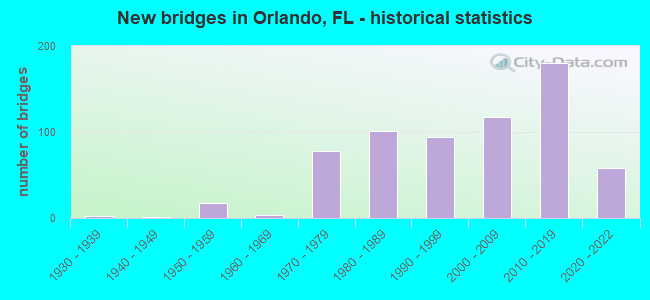
- New bridges - historical statistics
- 11920-1929
- 21930-1939
- 11940-1949
- 171950-1959
- 41960-1969
- 781970-1979
- 1011980-1989
- 941990-1999
- 1182000-2009
- 1802010-2019
- 582020-2022

- Reconstructed bridges - Historical Statistics
- 11950-1959
- 01960-1969
- 11970-1979
- 11980-1989
- 101990-1999
- 432000-2009
- 242010-2019
- 32020-2022


- Bridge Condition - Deck
- 35.5%Very good
- 56.2%Good
- 6.0%Satisfactory
- 2.0%Fair
- 0.3%Poor

- Bridge Condition - Superstructure
- 36.8%Very good
- 58.5%Good
- 2.0%Satisfactory
- 2.3%Fair
- 0.3%Poor

- Bridge Condition - Substructure
- 0.7%Excellent
- 41.8%Very good
- 55.2%Good
- 2.3%Satisfactory

- Bridge Condition - Channel
- 10.1%Excellent
- 27.8%Very good
- 54.4%Good
- 7.6%Satisfactory

- Bridge Condition - Culverts
- 20.0%Very good
- 35.0%Good
- 45.0%Satisfactory
Find on map >> Show street view
Structure Number: 754128, Location: At Westwood Blvd. (OCCC) (Lat: 28.420928, Lng: -81.467469), Route carried "on" structure: County highway , Year Built: 2003, Status: Open, Structure Length: 28.86m (94.69ft), Average Daily Traffic: 1,001 (year 2021), Truck Traffic: 1%, Average Future Daily Traffic: 1,737 (year 2042), Design Load: HS 20+Mod, Features Intersected: SR-528 (Beach Line Hwy), Facility Carried by Structure: W. Entrance Dr.
Minimum Vertical Clearance: 30+ m (98+ ft), Kilometerpoint: 0.000, Lanes on structure: 2, Lanes under structure: 10, Owner: County Highway Agency, Approaching Roadway Width: 9.3m (30.5ft), Skew: 9 degrees, Material/Design: Steel continuous, Design/Construction: Box Beam or Girders - Single/Spread, Number Of Spans In Main Unit: 5, Length of Maximum Span: 61.3m (201.1ft), Curb or Sidewalk Widths: Left: 2.3m (7.5ft), Right: 0.0m, Curb-To-Curb Width: 9.3m (30.5ft), Out-to-Out Width: 12.8m (42.0ft)
Condition: Deck: Very good, Superstructure: Good, Substructure: Very good, Operating Rating: 56.8 metric tons, Method Used To Determine Operating Rating: Load Factor (LF), Inventory Rating: 33.9 metric tons, Method Used To Determine Inventory Rating: Load Factor (LF), Structural Evaluation: Better than present minimum criteria, Deck Geometry: Somewhat better than minimum adequacy, Underclear: Superior to present desirable criteria, Approach Roadway Alignment: Equal to present desirable criteria, Designated Inspection Frequency: Every 24 months, Critical Feature Inspection Frequency: Every 24 months, Inspection Date: March 2021, Critical Feature Inspection Date: March 2021, Deck Structure Type: Concrete Cast-file-Place
Find on map >> Show street view
Structure Number: 75414, Location: OCCC-N End of 754128 (Lat: 28.421672, Lng: -81.468275), Route carried "on" structure: County highway , Year Built: 2003, Status: Open, Structure Length: 0.85m (2.79ft), Average Daily Traffic: 1,001 (year 2021), Truck Traffic: 2%, Average Future Daily Traffic: 1,501 (year 2042), Design Load: HS 25 or greater, Features Intersected: Utility Vault, Facility Carried by Structure: W. Entrance Dr.
Minimum Vertical Clearance: 30+ m (98+ ft), Kilometerpoint: 0.000, Lanes on structure: 2, Owner: County Highway Agency, Approaching Roadway Width: 9.3m (30.5ft), Material/Design: Concrete, Design/Construction: Culvert, Number Of Spans In Main Unit: 1, Length of Maximum Span: 8.5m (27.9ft), Curb or Sidewalk Widths: Left: 2.0m (6.6ft), Right: 0.5m (1.6ft)
Condition: Culverts: Very good, Operating Rating: 83.1 metric tons, Method Used To Determine Operating Rating: Load Factor (LF), Inventory Rating: 49.8 metric tons, Method Used To Determine Inventory Rating: Load Factor (LF), Structural Evaluation: Equal to present desirable criteria, Approach Roadway Alignment: Equal to present desirable criteria, Designated Inspection Frequency: Every 24 months, Inspection Date: March 2021
Find on map >> Show street view
Structure Number: 754144, Location: 1 Mi. West of SR423 (Lat: 28.432075, Lng: -81.440569), Route carried "on" structure: County highway , Year Built: 2009, Status: Open, Structure Length: 1.30m (4.27ft), Average Daily Traffic: 11,200 (year 2020), Truck Traffic: 5%, Average Future Daily Traffic: 19,432 (year 2042), Design Load: HL 93, Features Intersected: Central Canal, Facility Carried by Structure: Destination Pkwy
Minimum Vertical Clearance: 30+ m (98+ ft), Kilometerpoint: 0.016, Lanes on structure: 4, Owner: County Highway Agency, Approaching Roadway Width: 8.7m (28.5ft), Skew: 20 degrees, Material/Design: Concrete, Design/Construction: Culvert, Number Of Spans In Main Unit: 4, Length of Maximum Span: 3.6m (11.8ft)
Condition: Channel: Good, Culverts: Good, Structural Evaluation: Better than present minimum criteria, Waterway Adequacy: Superior to present desirable criteria, Approach Roadway Alignment: Equal to present desirable criteria, Designated Inspection Frequency: Every 24 months, Inspection Date: November 2020
Find on map >> Show street view
Structure Number: 754152, Location: 0.5 mi. W of SR-423 (Lat: 28.436500, Lng: -81.431722), Route carried "on" structure: County highway , Year Built: 2013, Status: Open, Structure Length: 15.54m (50.98ft), Average Daily Traffic: 11,200 (year 2021), Truck Traffic: 5%, Average Future Daily Traffic: 19,432 (year 2042), Design Load: HL 93, Features Intersected: SHINGLE CREEK, Facility Carried by Structure: DESTINATION PKY WB
Minimum Vertical Clearance: 30+ m (98+ ft), Kilometerpoint: 1.429, Lanes on structure: 2, Owner: County Highway Agency, Approaching Roadway Width: 12.4m (40.7ft), Material/Design: Prestressed concrete, Design/Construction: Stringer/Multi-beam, Number Of Spans In Main Unit: 6, Length of Maximum Span: 25.9m (85.0ft), Curb or Sidewalk Widths: Left: 1.5m (4.9ft), Right: 0.0m, Curb-To-Curb Width: 12.2m (40.0ft), Out-to-Out Width: 15.0m (49.2ft)
Condition: Deck: Very good, Superstructure: Very good, Substructure: Very good, Channel: Very good, Operating Rating: 45.7 metric tons, Method Used To Determine Operating Rating: Load and Resistance Factor (LRFR), Inventory Rating: 34.7 metric tons, Method Used To Determine Inventory Rating: Load and Resistance Factor (LRFR), Structural Evaluation: Equal to present desirable criteria, Deck Geometry: Better than present minimum criteria, Waterway Adequacy: Superior to present desirable criteria, Approach Roadway Alignment: Equal to present desirable criteria, Designated Inspection Frequency: Every 24 months, Inspection Date: May 2021, Deck Structure Type: Concrete Cast-file-Place
Find on map >> Show street view
Structure Number: 754153, Location: 0.5 mi. W of SR-423 (Lat: 28.436308, Lng: -81.431575), Route carried "on" structure: County highway , Year Built: 2013, Status: Open, Structure Length: 15.54m (50.98ft), Average Daily Traffic: 11,200 (year 2021), Truck Traffic: 5%, Average Future Daily Traffic: 19,432 (year 2042), Design Load: HL 93, Features Intersected: SHINGLE CREEK, Facility Carried by Structure: DESTINATION PKY EB
Minimum Vertical Clearance: 30+ m (98+ ft), Kilometerpoint: 1.429, Lanes on structure: 2, Owner: County Highway Agency, Approaching Roadway Width: 12.4m (40.7ft), Material/Design: Prestressed concrete, Design/Construction: Stringer/Multi-beam, Number Of Spans In Main Unit: 6, Length of Maximum Span: 25.9m (85.0ft), Curb or Sidewalk Widths: Left: 0.0m, Right: 1.5m (4.9ft), Curb-To-Curb Width: 12.2m (40.0ft), Out-to-Out Width: 15.0m (49.2ft)
Condition: Deck: Very good, Superstructure: Very good, Substructure: Very good, Channel: Very good, Operating Rating: 46.4 metric tons, Method Used To Determine Operating Rating: Load and Resistance Factor (LRFR), Inventory Rating: 40.2 metric tons, Method Used To Determine Inventory Rating: Load and Resistance Factor (LRFR), Structural Evaluation: Equal to present desirable criteria, Deck Geometry: Better than present minimum criteria, Waterway Adequacy: Superior to present desirable criteria, Approach Roadway Alignment: Equal to present desirable criteria, Designated Inspection Frequency: Every 24 months, Inspection Date: May 2021, Deck Structure Type: Concrete Cast-file-Place
Find on map >> Show street view
Structure Number: 754157, Location: 0.5 Mi W/O Sidney Hays Rd (Lat: 28.428811, Lng: -81.384092), Route carried "on" structure: County highway , Year Built: 2011, Status: Open, Structure Length: 0.62m (2.03ft), Average Daily Traffic: 5,200 (year 2021), Truck Traffic: 6%, Average Future Daily Traffic: 9,022 (year 2042), Design Load: HL 93, Features Intersected: Goodman-Rossman Canal, Facility Carried by Structure: Thorpe Road
Minimum Vertical Clearance: 30+ m (98+ ft), Kilometerpoint: 0.800, Lanes on structure: 2, Owner: County Highway Agency, Approaching Roadway Width: 7.2m (23.6ft), Material/Design: Concrete, Design/Construction: Culvert, Number Of Spans In Main Unit: 2, Length of Maximum Span: 3.0m (9.8ft)
Condition: Channel: Very good, Culverts: Very good, Operating Rating: 63.7 metric tons, Method Used To Determine Operating Rating: Load and Resistance Factor (LRFR), Inventory Rating: 49.0 metric tons, Method Used To Determine Inventory Rating: Load and Resistance Factor (LRFR), Structural Evaluation: Equal to present desirable criteria, Waterway Adequacy: Equal to present desirable criteria, Approach Roadway Alignment: Equal to present desirable criteria, Designated Inspection Frequency: Every 24 months, Inspection Date: December 2021, Deck Structure Type: Concrete Cast-file-Place
Find on map >> Show street view
Structure Number: 754158, Location: 0.7MI S/O SR552-Curry Fd (Lat: 28.499217, Lng: -81.255267), Route carried "on" structure: City street , Year Built: 2000, Status: Open, Structure Length: 2.72m (8.92ft), Average Daily Traffic: 14,900 (year 2022), Truck Traffic: 6%, Average Future Daily Traffic: 25,852 (year 2042), Design Load: HS 20, Features Intersected: Azalea Outfall Canal, Facility Carried by Structure: So Econ Trail
Minimum Vertical Clearance: 30.45m (99.90ft), Kilometerpoint: 2.517, Lanes on structure: 2, Owner: County Highway Agency, Approaching Roadway Width: 9.1m (29.9ft), Material/Design: Prestressed concrete, Design/Construction: Stringer/Multi-beam, Number Of Spans In Main Unit: 1, Length of Maximum Span: 27.2m (89.2ft), Curb or Sidewalk Widths: Left: 1.8m (5.9ft), Right: 0.0m, Curb-To-Curb Width: 9.1m (29.9ft), Out-to-Out Width: 11.9m (39.0ft)
Condition: Deck: Good, Superstructure: Very good, Substructure: Very good, Channel: Very good, Operating Rating: 49.6 metric tons, Method Used To Determine Operating Rating: Load and Resistance Factor (LRFR), Inventory Rating: 45.1 metric tons, Method Used To Determine Inventory Rating: Load and Resistance Factor (LRFR), Structural Evaluation: Equal to present desirable criteria, Deck Geometry: High priority of corrective action, Waterway Adequacy: Equal to present desirable criteria, Approach Roadway Alignment: Equal to present desirable criteria, Designated Inspection Frequency: Every 24 months, Inspection Date: January 2022, Deck Structure Type: Concrete Cast-file-Place
Find on map >> Show street view
Structure Number: 754167, Location: John Young Pkwy-Sand Lake (Lat: 28.450089, Lng: -81.427786), Route carried "on" structure: County highway 423, Year Built: 2019, Status: Open, Structure Length: 6.80m (22.31ft), Average Daily Traffic: 69,000 (year 2021), Truck Traffic: 4%, Average Future Daily Traffic: 119,715 (year 2042), Design Load: HL 93, Features Intersected: Sand Lake Road, Facility Carried by Structure: John Young Pkwy SB
Minimum Vertical Clearance: 30+ m (98+ ft), Kilometerpoint: 0.002, Lanes on structure: 3, Lanes under structure: 6, Owner: County Highway Agency, Approaching Roadway Width: 17.1m (56.1ft), Material/Design: Steel, Design/Construction: Stringer/Multi-beam, Number Of Spans In Main Unit: 1, Length of Maximum Span: 68.0m (223.1ft), Curb-To-Curb Width: 17.1m (56.1ft), Out-to-Out Width: 18.0m (59.1ft)
Condition: Deck: Very good, Superstructure: Good, Substructure: Very good, Operating Rating: 61.1 metric tons, Method Used To Determine Operating Rating: Load and Resistance Factor (LRFR), Inventory Rating: 47.0 metric tons, Method Used To Determine Inventory Rating: Load and Resistance Factor (LRFR), Structural Evaluation: Better than present minimum criteria, Deck Geometry: Superior to present desirable criteria, Underclear: Superior to present desirable criteria, Approach Roadway Alignment: Equal to present desirable criteria, Designated Inspection Frequency: Every 24 months, Inspection Date: October 2021, Deck Structure Type: Concrete Cast-file-Place, Wearing Surface/Protective System: Wearing Surface: Monolithic Concrete
Find on map >> Show street view
Structure Number: 754168, Location: John Young Pkwy-Sand Lake (Lat: 28.450622, Lng: -81.427561), Route carried "on" structure: County highway 423, Year Built: 2019, Status: Open, Structure Length: 6.80m (22.31ft), Average Daily Traffic: 69,000 (year 2021), Truck Traffic: 4%, Average Future Daily Traffic: 119,715 (year 2042), Design Load: HL 93, Features Intersected: Sand Lake Road, Facility Carried by Structure: John Young Pkwy NB
Minimum Vertical Clearance: 30+ m (98+ ft), Kilometerpoint: 0.002, Lanes on structure: 3, Lanes under structure: 6, Owner: County Highway Agency, Approaching Roadway Width: 17.1m (56.1ft), Material/Design: Steel, Design/Construction: Stringer/Multi-beam, Number Of Spans In Main Unit: 1, Length of Maximum Span: 68.0m (223.1ft), Curb-To-Curb Width: 17.1m (56.1ft), Out-to-Out Width: 18.0m (59.1ft)
Condition: Deck: Very good, Superstructure: Good, Substructure: Very good, Operating Rating: 61.1 metric tons, Method Used To Determine Operating Rating: Load and Resistance Factor (LRFR), Inventory Rating: 47.0 metric tons, Method Used To Determine Inventory Rating: Load and Resistance Factor (LRFR), Structural Evaluation: Better than present minimum criteria, Deck Geometry: Superior to present desirable criteria, Underclear: Superior to present desirable criteria, Approach Roadway Alignment: Equal to present desirable criteria, Designated Inspection Frequency: Every 24 months, Inspection Date: October 2021, Deck Structure Type: Concrete Cast-file-Place
Find on map >> Show street view
Structure Number: 754173, Location: 1.2 Miles N of SR-417 (Lat: 28.384306, Lng: -81.311583), Route carried "on" structure: County highway 5123, Year Built: 2019, Status: Open, Structure Length: 0.66m (2.17ft), Average Daily Traffic: 18,000 (year 2022), Truck Traffic: 13%, Average Future Daily Traffic: 31,230 (year 2042), Design Load: HL 93, Features Intersected: Taft Drainage Ditch, Facility Carried by Structure: Boggy Creek Road
Minimum Vertical Clearance: 30+ m (98+ ft), Kilometerpoint: 4.208, Lanes on structure: 5, Base Highway Network: Yes, Owner: County Highway Agency, Approaching Roadway Width: 23.8m (78.1ft), Skew: 20 degrees, Material/Design: Concrete, Design/Construction: Culvert, Number Of Spans In Main Unit: 1, Length of Maximum Span: 3.0m (9.8ft), Curb or Sidewalk Widths: Left: 1.5m (4.9ft), Right: 1.5m (4.9ft)
Condition: Channel: Very good, Culverts: Very good, Operating Rating: 49.4 metric tons, Method Used To Determine Operating Rating: Load and Resistance Factor (LRFR), Inventory Rating: 38.2 metric tons, Method Used To Determine Inventory Rating: Load and Resistance Factor (LRFR), Structural Evaluation: Equal to present desirable criteria, Waterway Adequacy: Equal to present desirable criteria, Approach Roadway Alignment: Equal to present desirable criteria, Designated Inspection Frequency: Every 24 months, Inspection Date: January 2022
Find on map >> Show street view
Structure Number: 7558, Location: 0.3 mile East of SR-435 (Lat: 28.504681, Lng: -81.454531), Route carried "on" structure: County highway , Year Built: 1960, Year Reconstructed: 1986, Status: Open, Structure Length: 3.54m (11.61ft), Average Daily Traffic: 31,500 (year 2021), Truck Traffic: 8%, Average Future Daily Traffic: 54,653 (year 2042), Design Load: HS 20, Features Intersected: Shingle Canal, Facility Carried by Structure: L. B. McLeod Road
Minimum Vertical Clearance: 30+ m (98+ ft), Kilometerpoint: 0.431, Lanes on structure: 4, Owner: County Highway Agency, Approaching Roadway Width: 16.6m (54.5ft), Material/Design: Prestressed concrete, Design/Construction: Slab, Number Of Spans In Main Unit: 5, Length of Maximum Span: 7.6m (24.9ft), Curb or Sidewalk Widths: Left: 0.3m (1.0ft), Right: 0.0m, Curb-To-Curb Width: 21.1m (69.2ft), Out-to-Out Width: 21.6m (70.9ft)
Condition: Deck: Good, Superstructure: Satisfactory, Substructure: Satisfactory, Channel: Good, Operating Rating: 52.4 metric tons, Method Used To Determine Operating Rating: Load Factor (LF), Inventory Rating: 31.5 metric tons, Method Used To Determine Inventory Rating: Load Factor (LF), Structural Evaluation: Equal to present minimum criteria, Deck Geometry: Superior to present desirable criteria, Waterway Adequacy: Somewhat better than minimum adequacy, Approach Roadway Alignment: Equal to present desirable criteria, Designated Inspection Frequency: Every 24 months, Inspection Date: September 2021, Deck Structure Type: Concrete Precast Panels, Wearing Surface/Protective System: Wearing Surface: Bituminous
Find on map >> Show street view
Structure Number: 755801, Location: 0.8 mile East of SR-435 (Lat: 28.497092, Lng: -81.445853), Route carried "on" structure: City street , Year Built: 1973, Status: Posted for load, Structure Length: 3.05m (10.01ft), Average Daily Traffic: 41,000 (year 2021), Truck Traffic: 5%, Average Future Daily Traffic: 71,135 (year 2042), Design Load: HS 20, Features Intersected: Shingle Creek, Facility Carried by Structure: Conroy Rd.
Minimum Vertical Clearance: 30+ m (98+ ft), Kilometerpoint: 1.342, Lanes on structure: 4, Owner: City or Municipal Highway Agency, Approaching Roadway Width: 23.0m (75.5ft), Skew: 23 degrees, Material/Design: Prestressed concrete, Design/Construction: Stringer/Multi-beam, Number Of Spans In Main Unit: 1, Length of Maximum Span: 30.5m (100.1ft), Curb or Sidewalk Widths: Left: 1.5m (4.9ft), Right: 1.5m (4.9ft), Curb-To-Curb Width: 23.0m (75.5ft), Out-to-Out Width: 26.6m (87.3ft)
Condition: Deck: Good, Superstructure: Good, Substructure: Good, Channel: Good, Operating Rating: 63.3 metric tons, Method Used To Determine Operating Rating: Load Factor (LF), Inventory Rating: 23.2 metric tons, Method Used To Determine Inventory Rating: Load Factor (LF), Structural Evaluation: Somewhat better than minimum adequacy, Deck Geometry: Superior to present desirable criteria, Waterway Adequacy: Equal to present minimum criteria, Approach Roadway Alignment: Equal to present desirable criteria, Designated Inspection Frequency: Every 24 months, Inspection Date: October 2021, Deck Structure Type: Concrete Cast-file-Place
Find on map >> Show street view
Structure Number: 755803, Location: 0.1 mi W of Marathon Ave (Lat: 28.512922, Lng: -81.414611), Route carried "on" structure: City street , Year Built: 1958, Status: Open, Structure Length: 1.84m (6.04ft), Average Daily Traffic: 2,216 (year 2021), Truck Traffic: 5%, Average Future Daily Traffic: 2,570 (year 2042), Design Load: H 20, Features Intersected: Catalina Canal, Facility Carried by Structure: Gulfstream Rd.
Minimum Vertical Clearance: 30+ m (98+ ft), Kilometerpoint: 0.000, Lanes on structure: 2, Owner: City or Municipal Highway Agency, Approaching Roadway Width: 7.9m (25.9ft), Material/Design: Concrete, Design/Construction: Slab, Number Of Spans In Main Unit: 4, Length of Maximum Span: 4.6m (15.1ft), Curb or Sidewalk Widths: Left: 1.4m (4.6ft), Right: 1.2m (3.9ft), Curb-To-Curb Width: 7.9m (25.9ft), Out-to-Out Width: 11.0m (36.1ft)
Condition: Deck: Satisfactory, Superstructure: Satisfactory, Substructure: Good, Channel: Very good, Operating Rating: 58.6 metric tons, Method Used To Determine Operating Rating: Load Factor (LF), Inventory Rating: 35.2 metric tons, Method Used To Determine Inventory Rating: Load Factor (LF), Structural Evaluation: Equal to present minimum criteria, Deck Geometry: High priority of corrective action, Waterway Adequacy: Better than present minimum criteria, Approach Roadway Alignment: Equal to present minimum criteria, Designated Inspection Frequency: Every 24 months, Underwater Inspection Frequency: Every 24 months, Inspection Date: October 2021, Underwater Inspection Date: October 2021, Deck Structure Type: Concrete Precast Panels
Find on map >> Show street view
Structure Number: 755804, Location: 0.1 mi E of Gulfstream Rd (Lat: 28.514603, Lng: -81.411458), Route carried "on" structure: City street , Year Built: 1958, Status: Open, Structure Length: 1.84m (6.04ft), Average Daily Traffic: 224 (year 2021), Truck Traffic: 1%, Average Future Daily Traffic: 260 (year 2042), Design Load: H 20, Features Intersected: Catalina Canal, Facility Carried by Structure: Catalina Drive
Minimum Vertical Clearance: 30+ m (98+ ft), Kilometerpoint: 0.000, Lanes on structure: 2, Owner: City or Municipal Highway Agency, Approaching Roadway Width: 7.9m (25.9ft), Material/Design: Concrete, Design/Construction: Slab, Number Of Spans In Main Unit: 4, Length of Maximum Span: 4.6m (15.1ft), Curb or Sidewalk Widths: Left: 1.4m (4.6ft), Right: 1.4m (4.6ft), Curb-To-Curb Width: 7.9m (25.9ft), Out-to-Out Width: 11.0m (36.1ft)
Condition: Deck: Fair, Superstructure: Fair, Substructure: Good, Channel: Good, Operating Rating: 54.3 metric tons, Method Used To Determine Operating Rating: Load Factor (LF), Inventory Rating: 32.7 metric tons, Method Used To Determine Inventory Rating: Load Factor (LF), Structural Evaluation: Somewhat better than minimum adequacy, Deck Geometry: Somewhat better than minimum adequacy, Waterway Adequacy: Better than present minimum criteria, Approach Roadway Alignment: Equal to present minimum criteria, Designated Inspection Frequency: Every 24 months, Underwater Inspection Frequency: Every 24 months, Inspection Date: October 2021, Underwater Inspection Date: October 2021, Deck Structure Type: Concrete Precast Panels
Find on map >> Show street view
Structure Number: 755806, Location: 0.6 mi E of Summerlin Ave (Lat: 28.544000, Lng: -81.358292), Route carried "on" structure: City street , Year Built: 1926, Status: Open, Structure Length: 1.83m (6.00ft), Average Daily Traffic: 1,192 (year 2021), Truck Traffic: 5%, Average Future Daily Traffic: 1,383 (year 2042), Features Intersected: Fern Creek, Facility Carried by Structure: Washington St.
Minimum Vertical Clearance: 30+ m (98+ ft), Kilometerpoint: 0.000, Lanes on structure: 2, Owner: City or Municipal Highway Agency, Approaching Roadway Width: 7.3m (24.0ft), Material/Design: Concrete, Design/Construction: Arch - Deck, Number Of Spans In Main Unit: 3, Length of Maximum Span: 6.1m (20.0ft), Curb or Sidewalk Widths: Left: 1.5m (4.9ft), Right: 1.5m (4.9ft), Curb-To-Curb Width: 7.3m (24.0ft), Out-to-Out Width: 11.0m (36.1ft)
Condition: Deck: Good, Superstructure: Good, Substructure: Good, Channel: Good, Operating Rating: 32.7 metric tons, Method Used To Determine Operating Rating: Field evaluation and documented engineering judgment, Inventory Rating: 27.2 metric tons, Method Used To Determine Inventory Rating: Field evaluation and documented engineering judgment, Structural Evaluation: Equal to present minimum criteria, Deck Geometry: Meets minimum limits, Waterway Adequacy: Equal to present desirable criteria, Approach Roadway Alignment: Better than present minimum criteria, Designated Inspection Frequency: Every 24 months, Inspection Date: November 2021, Wearing Surface/Protective System: Wearing Surface: Other
Find on map >> Show street view
Structure Number: 755807, Location: 0.1mi S of Ivanhoe Blvd (Lat: 28.566186, Lng: -81.384222), Route carried "on" structure: City street , Year Built: 1942, Status: Open, Structure Length: 0.91m (2.99ft), Average Daily Traffic: 1,965 (year 2021), Truck Traffic: 5%, Average Future Daily Traffic: 2,279 (year 2042), Features Intersected: Lake Ivanhoe, Facility Carried by Structure: Poinsettia Ave.
Minimum Vertical Clearance: 30+ m (98+ ft), Kilometerpoint: 0.000, Lanes on structure: 2, Owner: City or Municipal Highway Agency, Approaching Roadway Width: 9.2m (30.2ft), Material/Design: Concrete, Design/Construction: Tee Beam, Number Of Spans In Main Unit: 1, Length of Maximum Span: 9.1m (29.9ft), Curb or Sidewalk Widths: Left: 1.7m (5.6ft), Right: 1.7m (5.6ft), Curb-To-Curb Width: 9.2m (30.2ft), Out-to-Out Width: 13.4m (44.0ft)
Condition: Deck: Good, Superstructure: Good, Substructure: Good, Channel: Good, Operating Rating: 32.7 metric tons, Method Used To Determine Operating Rating: Field evaluation and documented engineering judgment, Inventory Rating: 27.2 metric tons, Method Used To Determine Inventory Rating: Field evaluation and documented engineering judgment, Structural Evaluation: Equal to present minimum criteria, Deck Geometry: Somewhat better than minimum adequacy, Waterway Adequacy: Better than present minimum criteria, Approach Roadway Alignment: Equal to present desirable criteria, Designated Inspection Frequency: Every 24 months, Inspection Date: November 2021, Deck Structure Type: Concrete Cast-file-Place, Wearing Surface/Protective System: Wearing Surface: Bituminous
Find on map >> Show street view
Structure Number: 755808, Location: 0.3 mi W of Mercy Drive (Lat: 28.581769, Lng: -81.436150), Route carried "on" structure: City street , Year Built: 1974, Status: Posted for load, Structure Length: 2.74m (8.99ft), Average Daily Traffic: 4,998 (year 2021), Truck Traffic: 20%, Average Future Daily Traffic: 5,798 (year 2042), Design Load: HS 20, Features Intersected: Flood Control Canal, Facility Carried by Structure: Seaboard Road
Minimum Vertical Clearance: 30+ m (98+ ft), Kilometerpoint: 0.669, Lanes on structure: 2, Owner: City or Municipal Highway Agency, Approaching Roadway Width: 8.0m (26.2ft), Material/Design: Prestressed concrete, Design/Construction: Channel Beam, Number Of Spans In Main Unit: 2, Length of Maximum Span: 13.7m (44.9ft), Curb or Sidewalk Widths: Left: 1.5m (4.9ft), Right: 1.5m (4.9ft), Curb-To-Curb Width: 8.0m (26.2ft), Out-to-Out Width: 11.6m (38.1ft)
Condition: Deck: Good, Superstructure: Satisfactory, Substructure: Good, Channel: Good, Operating Rating: 12.1 metric tons, Method Used To Determine Operating Rating: Load Factor (LF), Inventory Rating: 10.4 metric tons, Method Used To Determine Inventory Rating: Load Factor (LF), Structural Evaluation: High priority of corrective action, Deck Geometry: High priority of corrective action, Waterway Adequacy: Better than present minimum criteria, Approach Roadway Alignment: Equal to present desirable criteria, Bridge Posting: Required (Relationship of Operating Rating to Maximum Legal Load: 20.0 - 29.9% below), Designated Inspection Frequency: Every 24 months, Other Special Inspection Frequency: Every 12 months, Inspection Date: November 2021, Other Special Inspection Date: November 2021, Deck Structure Type: Concrete Cast-file-Place
Find on map >> Show street view
Structure Number: 755809, Location: .3miSE of Cinderlane Pkwy (Lat: 28.602169, Lng: -81.427006), Route carried "on" structure: City street , Year Built: 1971, Status: Open, Structure Length: 1.98m (6.50ft), Average Daily Traffic: 7,000 (year 2021), Truck Traffic: 3%, Average Future Daily Traffic: 12,145 (year 2042), Design Load: HS 20, Features Intersected: Wekiva Canal, Facility Carried by Structure: N Lake Orlando Pky
Minimum Vertical Clearance: 30+ m (98+ ft), Kilometerpoint: 1.772, Lanes on structure: 2, Owner: City or Municipal Highway Agency, Approaching Roadway Width: 10.8m (35.4ft), Material/Design: Prestressed concrete, Design/Construction: Slab, Number Of Spans In Main Unit: 3, Length of Maximum Span: 7.1m (23.3ft), Curb or Sidewalk Widths: Left: 1.0m (3.3ft), Right: 1.0m (3.3ft), Curb-To-Curb Width: 10.8m (35.4ft), Out-to-Out Width: 13.5m (44.3ft)
Condition: Deck: Fair, Superstructure: Fair, Substructure: Good, Channel: Satisfactory, Inventory Rating: 59.7 metric tons, Method Used To Determine Inventory Rating: Load Factor (LF), Structural Evaluation: Somewhat better than minimum adequacy, Deck Geometry: Meets minimum limits, Waterway Adequacy: Better than present minimum criteria, Approach Roadway Alignment: Better than present minimum criteria, Designated Inspection Frequency: Every 24 months, Underwater Inspection Frequency: Every 24 months, Inspection Date: November 2021, Underwater Inspection Date: November 2021, Deck Structure Type: Concrete Precast Panels, Wearing Surface/Protective System: Wearing Surface: Bituminous
Find on map >> Show street view
Structure Number: 755811, Location: 0.5Mi E. of Kirkman Rd (Lat: 28.482883, Lng: -81.452361), Route carried "on" structure: City street , Year Built: 1992, Status: Open, Structure Length: 6.98m (22.90ft), Average Daily Traffic: 26,000 (year 2021), Truck Traffic: 5%, Average Future Daily Traffic: 45,110 (year 2042), Design Load: HS 20, Features Intersected: SR-91 Fla Turnpike, Facility Carried by Structure: Vineland Road
Minimum Vertical Clearance: 30+ m (98+ ft), Kilometerpoint: 2.256, Lanes on structure: 4, Lanes under structure: 8, Owner: City or Municipal Highway Agency, Approaching Roadway Width: 21.2m (69.6ft), Skew: 23 degrees, Material/Design: Prestressed concrete, Design/Construction: Stringer/Multi-beam, Number Of Spans In Main Unit: 2, Length of Maximum Span: 34.9m (114.5ft), Curb or Sidewalk Widths: Left: 1.4m (4.6ft), Right: 0.0m, Curb-To-Curb Width: 21.2m (69.6ft), Out-to-Out Width: 24.0m (78.7ft)
Condition: Deck: Good, Superstructure: Fair, Substructure: Good, Operating Rating: 46.8 metric tons, Method Used To Determine Operating Rating: Load Factor (LF), Inventory Rating: 40.8 metric tons, Method Used To Determine Inventory Rating: Load Factor (LF), Structural Evaluation: Somewhat better than minimum adequacy, Deck Geometry: Superior to present desirable criteria, Underclear: Somewhat better than minimum adequacy, Approach Roadway Alignment: Equal to present desirable criteria, Designated Inspection Frequency: Every 24 months, Inspection Date: October 2021, Deck Structure Type: Concrete Cast-file-Place
Find on map >> Show street view
Structure Number: 755812, Location: At SR 527 & Lucerne Circl (Lat: 28.535325, Lng: -81.376600), Route carried "on" structure: City street , Year Built: 1991, Status: Open, Structure Length: 8.18m (26.84ft), Average Daily Traffic: 48,000 (year 2021), Truck Traffic: 4%, Average Future Daily Traffic: 83,280 (year 2042), Design Load: HS 20, Features Intersected: Lake Lucerne, Facility Carried by Structure: Rosalind Avenue
Minimum Vertical Clearance: 30+ m (98+ ft), Kilometerpoint: 0.026, Lanes on structure: 3, Base Highway Network: Yes, Owner: City or Municipal Highway Agency, Approaching Roadway Width: 11.0m (36.1ft), Material/Design: Prestressed concrete, Design/Construction: Slab, Number Of Spans In Main Unit: 6, Length of Maximum Span: 13.7m (44.9ft), Curb or Sidewalk Widths: Left: 1.2m (3.9ft), Right: 2.8m (9.2ft), Curb-To-Curb Width: 11.0m (36.1ft), Out-to-Out Width: 15.8m (51.8ft)
Condition: Deck: Good, Superstructure: Good, Substructure: Good, Channel: Very good, Operating Rating: 38.3 metric tons, Method Used To Determine Operating Rating: Load Factor (LF), Inventory Rating: 30.2 metric tons, Method Used To Determine Inventory Rating: Load Factor (LF), Structural Evaluation: Better than present minimum criteria, Deck Geometry: High priority of replacement, Waterway Adequacy: Equal to present desirable criteria, Approach Roadway Alignment: Better than present minimum criteria, Designated Inspection Frequency: Every 24 months, Underwater Inspection Frequency: Every 24 months, Inspection Date: November 2021, Underwater Inspection Date: November 2021, Deck Structure Type: Concrete Precast Panels
Find on map >> Show street view
Structure Number: 755813, Location: 0.25 mile West of SR-435 (Lat: 28.511594, Lng: -81.463208), Route carried "on" structure: City street , Year Built: 1992, Status: Posted for load, Structure Length: 2.04m (6.69ft), Average Daily Traffic: 7,000 (year 2021), Truck Traffic: 6%, Average Future Daily Traffic: 12,145 (year 2042), Design Load: HS 20, Features Intersected: Retention Pond, Facility Carried by Structure: Wilshire Drive
Minimum Vertical Clearance: 30+ m (98+ ft), Kilometerpoint: 0.034, Lanes on structure: 2, Owner: City or Municipal Highway Agency, Approaching Roadway Width: 8.3m (27.2ft), Material/Design: Concrete, Design/Construction: Slab, Number Of Spans In Main Unit: 2, Length of Maximum Span: 10.2m (33.5ft), Curb or Sidewalk Widths: Left: 1.8m (5.9ft), Right: 1.8m (5.9ft), Curb-To-Curb Width: 8.3m (27.2ft), Out-to-Out Width: 12.6m (41.3ft)
Condition: Deck: Poor, Superstructure: Poor, Substructure: Good, Channel: Very good, Operating Rating: 13.6 metric tons, Method Used To Determine Operating Rating: Load and Resistance Factor (LRFR), Inventory Rating: 8.4 metric tons, Method Used To Determine Inventory Rating: Load and Resistance Factor (LRFR), Structural Evaluation: High priority of corrective action, Deck Geometry: High priority of replacement, Waterway Adequacy: Superior to present desirable criteria, Approach Roadway Alignment: Better than present minimum criteria, Bridge Posting: Required (Relationship of Operating Rating to Maximum Legal Load: > 39.9% below), Designated Inspection Frequency: Every 24 months, Underwater Inspection Frequency: Every 24 months, Other Special Inspection Frequency: Every 12 months, Inspection Date: October 2021, Underwater Inspection Date: October 2021, Other Special Inspection Date: October 2021, Deck Structure Type: Concrete Cast-file-Place
Find on map >> Show street view
Structure Number: 755814, Location: 1.5 mi NE of Kirkman Road (Lat: 28.491214, Lng: -81.438372), Route carried "on" structure: City street , Year Built: 1995, Status: Open, Structure Length: 3.72m (12.20ft), Average Daily Traffic: 26,000 (year 2020), Truck Traffic: 5%, Average Future Daily Traffic: 45,110 (year 2042), Design Load: HS 20, Features Intersected: Shingle Creek, Facility Carried by Structure: Vineland Rd
Minimum Vertical Clearance: 30+ m (98+ ft), Kilometerpoint: 4.093, Lanes on structure: 4, Owner: City or Municipal Highway Agency, Approaching Roadway Width: 18.8m (61.7ft), Skew: 20 degrees, Material/Design: Prestressed concrete, Design/Construction: Tee Beam, Number Of Spans In Main Unit: 3, Length of Maximum Span: 12.2m (40.0ft), Curb or Sidewalk Widths: Left: 1.7m (5.6ft), Right: 1.7m (5.6ft), Curb-To-Curb Width: 18.8m (61.7ft), Out-to-Out Width: 29.4m (96.5ft)
Condition: Deck: Good, Superstructure: Good, Substructure: Good, Channel: Good, Operating Rating: 60.1 metric tons, Method Used To Determine Operating Rating: Load Factor (LF), Inventory Rating: 36.0 metric tons, Method Used To Determine Inventory Rating: Load Factor (LF), Structural Evaluation: Better than present minimum criteria, Deck Geometry: Equal to present minimum criteria, Waterway Adequacy: Equal to present desirable criteria, Approach Roadway Alignment: Equal to present desirable criteria, Designated Inspection Frequency: Every 24 months, Inspection Date: November 2020, Deck Structure Type: Concrete Cast-file-Place
Find on map >> Show street view
Structure Number: 755816, Location: 1.25 Mi S/O Curry Ford Rd (Lat: 28.491750, Lng: -81.254861), Route carried "on" structure: City street , Year Built: 2000, Status: Open, Structure Length: 2.12m (6.96ft), Average Daily Traffic: 14,900 (year 2021), Truck Traffic: 6%, Average Future Daily Traffic: 25,852 (year 2042), Design Load: HS 20, Features Intersected: E Orlando Outfall Canal, Facility Carried by Structure: So Econ Trail
Minimum Vertical Clearance: 30.45m (99.90ft), Kilometerpoint: 1.688, Lanes on structure: 2, Owner: City or Municipal Highway Agency, Approaching Roadway Width: 8.4m (27.6ft), Material/Design: Prestressed concrete, Design/Construction: Stringer/Multi-beam, Number Of Spans In Main Unit: 1, Length of Maximum Span: 21.2m (69.6ft), Curb or Sidewalk Widths: Left: 1.8m (5.9ft), Right: 0.0m, Curb-To-Curb Width: 9.1m (29.9ft), Out-to-Out Width: 11.9m (39.0ft)
Condition: Deck: Good, Superstructure: Good, Substructure: Good, Channel: Good, Operating Rating: 39.2 metric tons, Method Used To Determine Operating Rating: Load and Resistance Factor (LRFR), Inventory Rating: 33.3 metric tons, Method Used To Determine Inventory Rating: Load and Resistance Factor (LRFR), Structural Evaluation: Better than present minimum criteria, Deck Geometry: High priority of corrective action, Waterway Adequacy: Equal to present desirable criteria, Approach Roadway Alignment: Equal to present desirable criteria, Designated Inspection Frequency: Every 24 months, Inspection Date: December 2021, Deck Structure Type: Concrete Cast-file-Place
Find on map >> Show street view
Structure Number: 755817, Location: 0.4 mi S of Conroy Rd (Lat: 28.488286, Lng: -81.436000), Route carried "on" structure: City street , Year Built: 1999, Status: Open, Structure Length: 2.71m (8.89ft), Average Daily Traffic: 21,500 (year 2019), Truck Traffic: 5%, Average Future Daily Traffic: 2,821 (year 2040), Design Load: HS 25 or greater, Features Intersected: Shingle Creek, Facility Carried by Structure: Millenia Blvd.
Minimum Vertical Clearance: 30+ m (98+ ft), Kilometerpoint: 2.076, Lanes on structure: 4, Owner: City or Municipal Highway Agency, Approaching Roadway Width: 20.0m (65.6ft), Skew: 21 degrees, Material/Design: Concrete continuous, Design/Construction: Slab, Number Of Spans In Main Unit: 3, Length of Maximum Span: 9.8m (32.2ft), Curb or Sidewalk Widths: Left: 1.5m (4.9ft), Right: 2.4m (7.9ft), Curb-To-Curb Width: 20.0m (65.6ft), Out-to-Out Width: 27.5m (90.2ft)
Condition: Deck: Good, Superstructure: Good, Substructure: Good, Channel: Satisfactory, Operating Rating: 59.0 metric tons, Method Used To Determine Operating Rating: Load Factor (LF), Inventory Rating: 35.4 metric tons, Method Used To Determine Inventory Rating: Load Factor (LF), Structural Evaluation: Better than present minimum criteria, Deck Geometry: Better than present minimum criteria, Waterway Adequacy: Better than present minimum criteria, Approach Roadway Alignment: Equal to present desirable criteria, Designated Inspection Frequency: Every 24 months, Underwater Inspection Frequency: Every 24 months, Inspection Date: December 2020, Underwater Inspection Date: December 2020, Deck Structure Type: Concrete Cast-file-Place
Find on map >> Show street view
Structure Number: 755818, Location: Lake Nona Blvd over SR417 (Lat: 28.379342, Lng: -81.277367), Route carried "on" structure: Alternate City street , Year Built: 2005, Status: Open, Structure Length: 6.04m (19.82ft), Average Daily Traffic: 20,500 (year 2021), Truck Traffic: 6%, Average Future Daily Traffic: 35,568 (year 2042), Design Load: HL 93, Features Intersected: SR-417, Facility Carried by Structure: Lake Nona Blvd.
Minimum Vertical Clearance: 30.45m (99.90ft), Kilometerpoint: 5.863, Lanes on structure: 5, Lanes under structure: 4, Owner: City or Municipal Highway Agency, Approaching Roadway Width: 19.5m (64.0ft), Skew: 21 degrees, Material/Design: Prestressed concrete, Design/Construction: Stringer/Multi-beam, Number Of Spans In Main Unit: 2, Length of Maximum Span: 29.9m (98.1ft), Curb or Sidewalk Widths: Left: 2.9m (9.5ft), Right: 2.9m (9.5ft), Curb-To-Curb Width: 19.5m (64.0ft), Out-to-Out Width: 32.3m (106.0ft)
Condition: Deck: Good, Superstructure: Very good, Substructure: Very good, Operating Rating: 68.2 metric tons, Method Used To Determine Operating Rating: Load and Resistance Factor (LRFR), Inventory Rating: 58.2 metric tons, Method Used To Determine Inventory Rating: Load and Resistance Factor (LRFR), Structural Evaluation: Equal to present desirable criteria, Deck Geometry: Meets minimum limits, Underclear: Better than present minimum criteria, Approach Roadway Alignment: Equal to present desirable criteria, Designated Inspection Frequency: Every 24 months, Inspection Date: December 2021, Deck Structure Type: Concrete Cast-file-Place
Find on map >> Show street view
Structure Number: 755819, Location: 300 ft. North of SR-417 (Lat: 28.380181, Lng: -81.277467), Route carried "on" structure: City street , Year Built: 2005, Status: Open, Structure Length: 4.08m (13.39ft), Average Daily Traffic: 20,500 (year 2021), Truck Traffic: 6%, Average Future Daily Traffic: 35,568 (year 2042), Design Load: HL 93, Features Intersected: SR-417 OUC R/R, Facility Carried by Structure: Lake Nona Blvd.
Minimum Vertical Clearance: 30.45m (99.90ft), Kilometerpoint: 5.977, Lanes on structure: 4, Owner: City or Municipal Highway Agency, Approaching Roadway Width: 14.6m (47.9ft), Skew: 21 degrees, Material/Design: Prestressed concrete, Design/Construction: Stringer/Multi-beam, Number Of Spans In Main Unit: 1, Length of Maximum Span: 40.8m (133.9ft), Curb or Sidewalk Widths: Left: 2.9m (9.5ft), Right: 2.9m (9.5ft), Curb-To-Curb Width: 14.6m (47.9ft), Out-to-Out Width: 32.9m (107.9ft)
Condition: Deck: Very good, Superstructure: Very good, Substructure: Very good, Operating Rating: 54.5 metric tons, Method Used To Determine Operating Rating: Load and Resistance Factor (LRFR), Inventory Rating: 50.0 metric tons, Method Used To Determine Inventory Rating: Load and Resistance Factor (LRFR), Structural Evaluation: Equal to present desirable criteria, Deck Geometry: High priority of replacement, Underclear: Superior to present desirable criteria, Approach Roadway Alignment: Equal to present desirable criteria, Designated Inspection Frequency: Every 24 months, Inspection Date: December 2021, Deck Structure Type: Concrete Cast-file-Place
Find on map >> Show street view
Structure Number: 755821, Location: Oak Ridge Rd-SR-91 (Lat: 28.472125, Lng: -81.444369), Route carried "on" structure: County highway 528A, Year Built: 2007, Status: Open, Structure Length: 7.74m (25.39ft), Average Daily Traffic: 25,000 (year 2020), Truck Traffic: 4%, Average Future Daily Traffic: 43,375 (year 2042), Design Load: HL 93, Features Intersected: SR-91 Fla Turnpike, Facility Carried by Structure: Oak Ridge Rd.
Minimum Vertical Clearance: 30.45m (99.90ft), Kilometerpoint: 0.558, Lanes on structure: 4, Lanes under structure: 8, Owner: City or Municipal Highway Agency, Approaching Roadway Width: 23.9m (78.4ft), Skew: 3 degrees, Material/Design: Prestressed concrete, Design/Construction: Stringer/Multi-beam, Number Of Spans In Main Unit: 2, Length of Maximum Span: 38.7m (127.0ft), Curb or Sidewalk Widths: Left: 2.0m (6.6ft), Right: 4.3m (14.1ft), Curb-To-Curb Width: 23.8m (78.1ft), Out-to-Out Width: 31.4m (103.0ft)
Condition: Deck: Very good, Superstructure: Good, Substructure: Good, Operating Rating: 59.8 metric tons, Method Used To Determine Operating Rating: Load and Resistance Factor (LRFR), Inventory Rating: 55.2 metric tons, Method Used To Determine Inventory Rating: Load and Resistance Factor (LRFR), Structural Evaluation: Better than present minimum criteria, Deck Geometry: Superior to present desirable criteria, Underclear: Equal to present minimum criteria, Approach Roadway Alignment: Equal to present desirable criteria, Designated Inspection Frequency: Every 24 months, Inspection Date: March 2020, Deck Structure Type: Concrete Cast-file-Place
Find on map >> Show street view
Structure Number: 755822, Location: 0.2 Mile East of SR-435 (Lat: 28.513731, Lng: -81.454678), Route carried "on" structure: City street , Year Built: 2004, Status: Open, Structure Length: 2.74m (8.99ft), Average Daily Traffic: 9,400 (year 2020), Truck Traffic: 4%, Average Future Daily Traffic: 1,250 (year 2042), Design Load: HS 20, Features Intersected: Shingle Creek, Facility Carried by Structure: Metrowest Blvd.
Minimum Vertical Clearance: 30+ m (98+ ft), Kilometerpoint: 0.422, Lanes on structure: 2, Owner: City or Municipal Highway Agency, Approaching Roadway Width: 9.1m (29.9ft), Material/Design: Prestressed concrete, Design/Construction: Stringer/Multi-beam, Number Of Spans In Main Unit: 1, Length of Maximum Span: 27.4m (89.9ft), Curb or Sidewalk Widths: Left: 1.6m (5.2ft), Right: 1.5m (4.9ft), Curb-To-Curb Width: 9.1m (29.9ft), Out-to-Out Width: 14.7m (48.2ft)
Condition: Deck: Good, Superstructure: Good, Substructure: Good, Channel: Good, Operating Rating: 71.3 metric tons, Method Used To Determine Operating Rating: Load and Resistance Factor (LRFR), Inventory Rating: 55.0 metric tons, Method Used To Determine Inventory Rating: Load and Resistance Factor (LRFR), Structural Evaluation: Better than present minimum criteria, Deck Geometry: High priority of corrective action, Waterway Adequacy: Equal to present minimum criteria, Approach Roadway Alignment: Equal to present desirable criteria, Designated Inspection Frequency: Every 24 months, Inspection Date: March 2020, Deck Structure Type: Concrete Cast-file-Place
Find on map >> Show street view
Structure Number: 755823, Location: Anderson Street over I-4 (Lat: 28.536139, Lng: -81.382833), Route carried "on" structure: City street , Year Built: 2008, Status: Open, Structure Length: 25.39m (83.30ft), Average Daily Traffic: 18,000 (year 2020), Truck Traffic: 7%, Average Future Daily Traffic: 37,800 (year 2040), Design Load: HL 93, Features Intersected: I-4 & SunRail RR, Facility Carried by Structure: Anderson Street
Minimum Vertical Clearance: 5.46m (17.91ft), Kilometerpoint: 1.912, Lanes on structure: 4, Lanes under structure: 13, Owner: City or Municipal Highway Agency, Approaching Roadway Width: 16.6m (54.5ft), Skew: 29 degrees, Material/Design: Steel continuous, Design/Construction: Stringer/Multi-beam, Number Of Spans In Main Unit: 7, Length of Maximum Span: 42.7m (140.1ft), Curb or Sidewalk Widths: Left: 0.0m, Right: 2.1m (6.9ft), Curb-To-Curb Width: 16.6m (54.5ft), Out-to-Out Width: 20.1m (65.9ft)
Condition: Deck: Good, Superstructure: Very good, Substructure: Very good, Operating Rating: 43.2 metric tons, Method Used To Determine Operating Rating: Load and Resistance Factor (LRFR), Inventory Rating: 33.3 metric tons, Method Used To Determine Inventory Rating: Load and Resistance Factor (LRFR), Structural Evaluation: Equal to present desirable criteria, Deck Geometry: Somewhat better than minimum adequacy, Underclear: Equal to present minimum criteria, Approach Roadway Alignment: Equal to present desirable criteria, Designated Inspection Frequency: Every 24 months, Critical Feature Inspection Frequency: Every 24 months, Inspection Date: July 2020, Critical Feature Inspection Date: July 2020, Deck Structure Type: Concrete Cast-file-Place
Find on map >> Show street view
Structure Number: 755824, Location: 0.3 Miles N. of Conroy Rd (Lat: 28.501389, Lng: -81.442417), Route carried "on" structure: City street , Year Built: 2012, Status: Open, Structure Length: 0.68m (2.23ft), Average Daily Traffic: 9,000 (year 2022), Truck Traffic: 6%, Average Future Daily Traffic: 15,615 (year 2042), Design Load: HL 93, Features Intersected: Northgate Canal, Facility Carried by Structure: P Barack Obama Pky
Minimum Vertical Clearance: 30+ m (98+ ft), Kilometerpoint: 3.354, Lanes on structure: 4, Owner: City or Municipal Highway Agency, Approaching Roadway Width: 18.0m (59.1ft), Skew: 20 degrees, Material/Design: Concrete, Design/Construction: Culvert, Number Of Spans In Main Unit: 1, Length of Maximum Span: 6.8m (22.3ft)
Condition: Channel: Good, Culverts: Good, Operating Rating: 53.6 metric tons, Method Used To Determine Operating Rating: Load and Resistance Factor (LRFR), Inventory Rating: 42.4 metric tons, Method Used To Determine Inventory Rating: Load and Resistance Factor (LRFR), Structural Evaluation: Better than present minimum criteria, Waterway Adequacy: Superior to present desirable criteria, Approach Roadway Alignment: Equal to present desirable criteria, Designated Inspection Frequency: Every 24 months, Inspection Date: January 2022
Find on map >> Show street view
Structure Number: 755825, Location: At Anderson St. Ramp (Lat: 28.536700, Lng: -81.380650), Route carried "on" structure: City street , Year Built: 2009, Status: Posted for load, Structure Length: 1.28m (4.20ft), Average Daily Traffic: 200 (year 2021), Average Future Daily Traffic: 200 (year 2042), Features Intersected: CNL Parking Garage, Facility Carried by Structure: Entrance CNL park
Minimum Vertical Clearance: 2.07m (6.79ft), Kilometerpoint: 0.016, Lanes on structure: 2, Owner: City or Municipal Highway Agency, Approaching Roadway Width: 12.6m (41.3ft), Material/Design: Prestressed concrete, Design/Construction: Slab, Number Of Spans In Main Unit: 1, Length of Maximum Span: 12.8m (42.0ft), Curb-To-Curb Width: 12.6m (41.3ft), Out-to-Out Width: 13.5m (44.3ft)
Condition: Deck: Fair, Superstructure: Fair, Substructure: Very good, Operating Rating: 19.2 metric tons, Method Used To Determine Operating Rating: Load and Resistance Factor (LRFR), Inventory Rating: 10.8 metric tons, Method Used To Determine Inventory Rating: Load and Resistance Factor (LRFR), Structural Evaluation: Meets minimum limits, Deck Geometry: Superior to present desirable criteria, Approach Roadway Alignment: Equal to present desirable criteria, Bridge Posting: Required (Relationship of Operating Rating to Maximum Legal Load: > 39.9% below), Designated Inspection Frequency: Every 24 months, Other Special Inspection Frequency: Every 12 months, Inspection Date: Febuary 2022, Other Special Inspection Date: Febuary 2021, Deck Structure Type: Concrete Cast-file-Place
Find on map >> Show street view
Structure Number: 755826, Location: 0.15 Mi. W. of CR-15 (Lat: 28.372411, Lng: -81.246794), Route carried "on" structure: Business City street , Year Built: 2011, Status: Open, Structure Length: 1.68m (5.51ft), Average Daily Traffic: 9,600 (year 2021), Truck Traffic: 6%, Average Future Daily Traffic: 16,656 (year 2042), Design Load: HL 93, Features Intersected: Drainage Canal, Facility Carried by Structure: Tavistock Lakes Bl
Minimum Vertical Clearance: 30+ m (98+ ft), Kilometerpoint: 3.104, Lanes on structure: 2, Owner: City or Municipal Highway Agency, Approaching Roadway Width: 10.1m (33.1ft), Material/Design: Prestressed concrete, Design/Construction: Stringer/Multi-beam, Number Of Spans In Main Unit: 1, Length of Maximum Span: 16.2m (53.1ft), Curb or Sidewalk Widths: Left: 2.0m (6.6ft), Right: 2.0m (6.6ft), Curb-To-Curb Width: 10.1m (33.1ft), Out-to-Out Width: 15.6m (51.2ft)
Condition: Deck: Good, Superstructure: Good, Substructure: Good, Channel: Very good, Operating Rating: 64.3 metric tons, Method Used To Determine Operating Rating: Load and Resistance Factor (LRFR), Inventory Rating: 49.6 metric tons, Method Used To Determine Inventory Rating: Load and Resistance Factor (LRFR), Structural Evaluation: Better than present minimum criteria, Deck Geometry: Meets minimum limits, Waterway Adequacy: Superior to present desirable criteria, Approach Roadway Alignment: Equal to present desirable criteria, Designated Inspection Frequency: Every 24 months, Inspection Date: August 2021, Deck Structure Type: Concrete Cast-file-Place, Wearing Surface/Protective System: Wearing Surface: Other
Find on map >> Show street view
Structure Number: 755829, Location: 0.3 Miles W of CR-15 (Lat: 28.379922, Lng: -81.249481), Route carried "on" structure: City street , Year Built: 2018, Status: Open, Structure Length: 0.78m (2.56ft), Average Daily Traffic: 2,500 (year 2018), Truck Traffic: 5%, Average Future Daily Traffic: 5,500 (year 2034), Design Load: HL 93, Features Intersected: Drainage Canal, Facility Carried by Structure: South Nemours Pkwy
Minimum Vertical Clearance: 30+ m (98+ ft), Kilometerpoint: 0.000, Lanes on structure: 2, Owner: City or Municipal Highway Agency, Approaching Roadway Width: 7.6m (24.9ft), Material/Design: Concrete, Design/Construction: Culvert, Number Of Spans In Main Unit: 2, Length of Maximum Span: 3.9m (12.8ft), Curb or Sidewalk Widths: Left: 3.0m (9.8ft), Right: 0.0m
Condition: Channel: Good, Culverts: Good, Operating Rating: 47.0 metric tons, Method Used To Determine Operating Rating: Load and Resistance Factor (LRFR), Inventory Rating: 36.3 metric tons, Method Used To Determine Inventory Rating: Load and Resistance Factor (LRFR), Structural Evaluation: Better than present minimum criteria, Waterway Adequacy: Equal to present desirable criteria, Approach Roadway Alignment: Somewhat better than minimum adequacy, Designated Inspection Frequency: Every 24 months, Inspection Date: October 2020
Find on map >> Show street view
Structure Number: 755903, Location: OIA East side of terminal (Lat: 28.430356, Lng: -81.305111), Route carried "on" structure: ServiceCity street , Year Built: 1981, Year Reconstructed: 1990, Status: Open, Structure Length: 1.95m (6.40ft), Average Daily Traffic: 40,000 (year 2020), Truck Traffic: 4%, Average Future Daily Traffic: 69,400 (year 2042), Design Load: H 20, Features Intersected: Tug Tunnel South, Facility Carried by Structure: Jeff Fuqua Blvd.
Minimum Vertical Clearance: 5.06m (16.60ft), Kilometerpoint: 0.586, Lanes on structure: 4, Lanes under structure: 2, Base Highway Network: Yes, Owner: City or Municipal Highway Agency, Approaching Roadway Width: 16.0m (52.5ft), Skew: 3 degrees, Material/Design: Concrete, Design/Construction: Frame, Number Of Spans In Main Unit: 2, Length of Maximum Span: 9.8m (32.2ft), Curb-To-Curb Width: 16.9m (55.4ft), Out-to-Out Width: 18.2m (59.7ft)
Condition: Deck: Good, Superstructure: Good, Substructure: Good, Operating Rating: 39.6 metric tons, Method Used To Determine Operating Rating: Load Factor (LF), Inventory Rating: 23.8 metric tons, Method Used To Determine Inventory Rating: Load Factor (LF), Structural Evaluation: Somewhat better than minimum adequacy, Deck Geometry: Somewhat better than minimum adequacy, Underclear: High priority of corrective action, Approach Roadway Alignment: Equal to present desirable criteria, Designated Inspection Frequency: Every 24 months, Inspection Date: Febuary 2020, Deck Structure Type: Concrete Cast-file-Place, Wearing Surface/Protective System: Wearing Surface: Bituminous
Find on map >> Show street view
Structure Number: 755904, Location: Orlando Internatl Airport (Lat: 28.443347, Lng: -81.310669), Route carried "on" structure: ServiceCity street , Year Built: 1981, Year Reconstructed: 2007, Status: Open, Structure Length: 4.66m (15.29ft), Average Daily Traffic: 20,500 (year 2020), Truck Traffic: 6%, Average Future Daily Traffic: 35,568 (year 2042), Design Load: HL 93, Features Intersected: Bypass Canal, Facility Carried by Structure: Airport Entrnce Rd
Minimum Vertical Clearance: 30+ m (98+ ft), Kilometerpoint: 0.000, Lanes on structure: 5, Base Highway Network: Yes, Owner: City or Municipal Highway Agency, Approaching Roadway Width: 24.4m (80.1ft), Skew: 2 degrees, Material/Design: Prestressed concrete, Design/Construction: Stringer/Multi-beam, Number Of Spans In Main Unit: 3, Length of Maximum Span: 15.5m (50.9ft), Curb-To-Curb Width: 24.4m (80.1ft), Out-to-Out Width: 25.4m (83.3ft)
Condition: Deck: Good, Superstructure: Good, Substructure: Good, Channel: Good, Operating Rating: 45.1 metric tons, Method Used To Determine Operating Rating: Load and Resistance Factor (LRFR), Inventory Rating: 34.7 metric tons, Method Used To Determine Inventory Rating: Load and Resistance Factor (LRFR), Structural Evaluation: Better than present minimum criteria, Deck Geometry: Superior to present desirable criteria, Waterway Adequacy: Equal to present desirable criteria, Approach Roadway Alignment: Equal to present desirable criteria, Designated Inspection Frequency: Every 24 months, Inspection Date: Febuary 2020, Deck Structure Type: Concrete Cast-file-Place
Find on map >> Show street view
Structure Number: 755905, Location: Orlando Internatl Airport (Lat: 28.444144, Lng: -81.306931), Route carried "on" structure: ServiceCity street , Year Built: 1981, Year Reconstructed: 2007, Status: Open, Structure Length: 4.66m (15.29ft), Average Daily Traffic: 40,000 (year 2020), Truck Traffic: 5%, Average Future Daily Traffic: 69,400 (year 2042), Design Load: HL 93, Features Intersected: Bypass Canal, Facility Carried by Structure: North exit Road
Minimum Vertical Clearance: 30+ m (98+ ft), Kilometerpoint: 2.068, Lanes on structure: 4, Base Highway Network: Yes, Owner: City or Municipal Highway Agency, Approaching Roadway Width: 20.7m (67.9ft), Skew: 1 degrees, Material/Design: Prestressed concrete, Design/Construction: Stringer/Multi-beam, Number Of Spans In Main Unit: 3, Length of Maximum Span: 15.5m (50.9ft), Curb-To-Curb Width: 20.7m (67.9ft), Out-to-Out Width: 21.7m (71.2ft)
Condition: Deck: Good, Superstructure: Good, Substructure: Good, Channel: Good, Operating Rating: 45.4 metric tons, Method Used To Determine Operating Rating: Load and Resistance Factor (LRFR), Inventory Rating: 34.9 metric tons, Method Used To Determine Inventory Rating: Load and Resistance Factor (LRFR), Structural Evaluation: Better than present minimum criteria, Deck Geometry: Superior to present desirable criteria, Waterway Adequacy: Equal to present desirable criteria, Approach Roadway Alignment: Equal to present desirable criteria, Designated Inspection Frequency: Every 24 months, Inspection Date: Febuary 2020, Deck Structure Type: Concrete Cast-file-Place
Find on map >> Show street view
Structure Number: 755906, Location: OIA West side of Terminal (Lat: 28.431967, Lng: -81.311336), Route carried "on" structure: ServiceCity street , Year Built: 1981, Status: Open, Structure Length: 0.88m (2.89ft), Average Daily Traffic: 20,500 (year 2020), Truck Traffic: 6%, Average Future Daily Traffic: 35,568 (year 2042), Design Load: H 20, Features Intersected: Tug Tunnel North, Facility Carried by Structure: Jeff Fuqua Blvd.
Minimum Vertical Clearance: 4.45m (14.60ft), Kilometerpoint: 1.329, Lanes on structure: 3, Lanes under structure: 2, Base Highway Network: Yes, Owner: City or Municipal Highway Agency, Approaching Roadway Width: 12.2m (40.0ft), Skew: 3 degrees, Material/Design: Concrete, Design/Construction: Frame, Number Of Spans In Main Unit: 1, Length of Maximum Span: 8.8m (28.9ft), Curb-To-Curb Width: 12.2m (40.0ft), Out-to-Out Width: 14.0m (45.9ft)
Condition: Deck: Good, Superstructure: Good, Substructure: Good, Operating Rating: 43.3 metric tons, Method Used To Determine Operating Rating: Load Factor (LF), Inventory Rating: 25.9 metric tons, Method Used To Determine Inventory Rating: Load Factor (LF), Structural Evaluation: Equal to present minimum criteria, Deck Geometry: Meets minimum limits, Underclear: High priority of corrective action, Approach Roadway Alignment: Equal to present desirable criteria, Designated Inspection Frequency: Every 24 months, Inspection Date: Febuary 2020, Deck Structure Type: Concrete Cast-file-Place, Wearing Surface/Protective System: Wearing Surface: Bituminous
Find on map >> Show street view
Structure Number: 755907, Location: OIA West side of Terminal (Lat: 28.430297, Lng: -81.311336), Route carried "on" structure: ServiceCity street , Year Built: 1981, Status: Open, Structure Length: 0.88m (2.89ft), Average Daily Traffic: 20,500 (year 2020), Truck Traffic: 6%, Average Future Daily Traffic: 35,568 (year 2042), Design Load: H 20, Features Intersected: Tug Tunnel South, Facility Carried by Structure: Jeff Fuqua Blvd.
Minimum Vertical Clearance: 4.39m (14.40ft), Kilometerpoint: 1.526, Lanes on structure: 3, Lanes under structure: 2, Base Highway Network: Yes, Owner: City or Municipal Highway Agency, Approaching Roadway Width: 12.2m (40.0ft), Skew: 2 degrees, Material/Design: Concrete, Design/Construction: Frame, Number Of Spans In Main Unit: 1, Length of Maximum Span: 8.8m (28.9ft), Curb-To-Curb Width: 12.2m (40.0ft), Out-to-Out Width: 14.0m (45.9ft)
Condition: Deck: Good, Superstructure: Good, Substructure: Good, Operating Rating: 43.3 metric tons, Method Used To Determine Operating Rating: Load Factor (LF), Inventory Rating: 25.9 metric tons, Method Used To Determine Inventory Rating: Load Factor (LF), Structural Evaluation: Equal to present minimum criteria, Deck Geometry: Meets minimum limits, Underclear: High priority of corrective action, Approach Roadway Alignment: Better than present minimum criteria, Designated Inspection Frequency: Every 24 months, Inspection Date: Febuary 2020, Deck Structure Type: Concrete Cast-file-Place, Wearing Surface/Protective System: Wearing Surface: Bituminous
Find on map >> Show street view
Structure Number: 755908, Location: N. Side of Terminal OIA (Lat: 28.432178, Lng: -81.310314), Route carried "on" structure: ServiceCity street , Year Built: 1981, Year Reconstructed: 1990, Status: Posted for load, Structure Length: 37.37m (122.60ft), Average Daily Traffic: 4,273 (year 2020), Truck Traffic: 5%, Average Future Daily Traffic: 4,940 (year 2042), Design Load: H 15, Features Intersected: Parking Garage, Facility Carried by Structure: 2nd Level Deplan A
Minimum Vertical Clearance: 4.36m (14.30ft), Kilometerpoint: 0.016, Lanes on structure: 4, Lanes under structure: 4, Owner: City or Municipal Highway Agency, Approaching Roadway Width: 8.3m (27.2ft), Material/Design: Concrete, Design/Construction: Tee Beam, Number Of Spans In Main Unit: 36, Length of Maximum Span: 11.4m (37.4ft), Curb or Sidewalk Widths: Left: 0.5m (1.6ft), Right: 4.2m (13.8ft), Curb-To-Curb Width: 12.8m (42.0ft), Out-to-Out Width: 18.8m (61.7ft)
Condition: Deck: Good, Superstructure: Good, Substructure: Good, Operating Rating: 15.7 metric tons, Method Used To Determine Operating Rating: Load Factor (LF), Inventory Rating: 9.4 metric tons, Method Used To Determine Inventory Rating: Load Factor (LF), Structural Evaluation: High priority of corrective action, Deck Geometry: High priority of replacement, Underclear: High priority of corrective action, Approach Roadway Alignment: Better than present minimum criteria, Bridge Posting: Required (Relationship of Operating Rating to Maximum Legal Load: 30.0 - 39.9% below), Designated Inspection Frequency: Every 24 months, Other Special Inspection Frequency: Every 12 months, Inspection Date: Febuary 2020, Other Special Inspection Date: Febuary 2021, Deck Structure Type: Concrete Cast-file-Place
Find on map >> Show street view
Structure Number: 755909, Location: S. Side of Terminal OIA (Lat: 28.430000, Lng: -81.307736), Route carried "on" structure: ServiceCity street , Year Built: 1981, Year Reconstructed: 1990, Status: Posted for load, Structure Length: 37.37m (122.60ft), Average Daily Traffic: 5,341 (year 2020), Average Future Daily Traffic: 6,195 (year 2042), Design Load: H 15, Features Intersected: Parking Garage, Facility Carried by Structure: 2nd Level Deplan B
Minimum Vertical Clearance: 4.40m (14.44ft), Kilometerpoint: 0.016, Lanes on structure: 4, Lanes under structure: 4, Owner: City or Municipal Highway Agency, Approaching Roadway Width: 10.6m (34.8ft), Material/Design: Concrete, Design/Construction: Tee Beam, Number Of Spans In Main Unit: 36, Length of Maximum Span: 10.4m (34.1ft), Curb or Sidewalk Widths: Left: 5.0m (16.4ft), Right: 1.0m (3.3ft), Curb-To-Curb Width: 12.8m (42.0ft), Out-to-Out Width: 19.1m (62.7ft)
Condition: Deck: Satisfactory, Superstructure: Good, Substructure: Good, Operating Rating: 25.1 metric tons, Method Used To Determine Operating Rating: Load Factor (LF), Inventory Rating: 15.1 metric tons, Method Used To Determine Inventory Rating: Load Factor (LF), Structural Evaluation: High priority of corrective action, Deck Geometry: High priority of replacement, Underclear: High priority of corrective action, Approach Roadway Alignment: Equal to present desirable criteria, Designated Inspection Frequency: Every 24 months, Inspection Date: Febuary 2020, Deck Structure Type: Concrete Cast-file-Place
Find on map >> Show street view
Structure Number: 75591, Location: N. Side of Terminal OIA (Lat: 28.432086, Lng: -81.307597), Route carried "on" structure: ServiceCity street , Year Built: 1981, Year Reconstructed: 1990, Status: Posted for load, Structure Length: 53.86m (176.71ft), Average Daily Traffic: 15,001 (year 2020), Truck Traffic: 5%, Average Future Daily Traffic: 26,027 (year 2042), Design Load: H 15, Features Intersected: 2nd Level Deplane A, Facility Carried by Structure: 3rdLevel Enplane A
Minimum Vertical Clearance: 5.49m (18.01ft), Kilometerpoint: 0.016, Lanes on structure: 4, Lanes under structure: 4, Owner: City or Municipal Highway Agency, Approaching Roadway Width: 7.3m (24.0ft), Material/Design: Prestressed concrete, Design/Construction: Tee Beam, Number Of Spans In Main Unit: 48, Length of Maximum Span: 27.4m (89.9ft), Curb or Sidewalk Widths: Left: 0.4m (1.3ft), Right: 4.4m (14.4ft), Curb-To-Curb Width: 13.5m (44.3ft), Out-to-Out Width: 18.9m (62.0ft)
Condition: Deck: Satisfactory, Superstructure: Satisfactory, Substructure: Satisfactory, Operating Rating: 18.0 metric tons, Method Used To Determine Operating Rating: Load Factor (LF), Inventory Rating: 10.8 metric tons, Method Used To Determine Inventory Rating: Load Factor (LF), Structural Evaluation: High priority of corrective action, Deck Geometry: High priority of replacement, Underclear: Meets minimum limits, Approach Roadway Alignment: Equal to present desirable criteria, Bridge Posting: Required (Relationship of Operating Rating to Maximum Legal Load: 20.0 - 29.9% below), Designated Inspection Frequency: Every 24 months, Critical Feature Inspection Frequency: Every 12 months, Other Special Inspection Frequency: Every 12 months, Inspection Date: Febuary 2020, Critical Feature Inspection Date: Febuary 2021, Other Special Inspection Date: Febuary 2021, Deck Structure Type: Concrete Cast-file-Place