Bridge Statistics for Orlando, Florida (FL)
Condition, Traffic, Stress, Structural Evaluation, Project Costs
- National Bridge Inventory (NBI) Statistics
- 654Number of bridges
- 11,050ft / 3,368mTotal length
- $609,000Total costs
- 23,147,954Total average daily traffic
- 1,641,430Total average daily truck traffic
- National Bridge Inventory (NBI) Registered Bridges for Orlando
- No street view available for this location
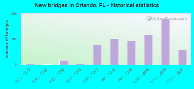
- New bridges - historical statistics
- 11920-1929
- 21930-1939
- 11940-1949
- 171950-1959
- 41960-1969
- 781970-1979
- 1011980-1989
- 941990-1999
- 1182000-2009
- 1802010-2019
- 582020-2022

- Reconstructed bridges - Historical Statistics
- 11950-1959
- 01960-1969
- 11970-1979
- 11980-1989
- 101990-1999
- 432000-2009
- 242010-2019
- 32020-2022


- Bridge Condition - Deck
- 35.5%Very good
- 56.2%Good
- 6.0%Satisfactory
- 2.0%Fair
- 0.3%Poor

- Bridge Condition - Superstructure
- 36.8%Very good
- 58.5%Good
- 2.0%Satisfactory
- 2.3%Fair
- 0.3%Poor

- Bridge Condition - Substructure
- 0.7%Excellent
- 41.8%Very good
- 55.2%Good
- 2.3%Satisfactory

- Bridge Condition - Channel
- 10.1%Excellent
- 27.8%Very good
- 54.4%Good
- 7.6%Satisfactory

- Bridge Condition - Culverts
- 20.0%Very good
- 35.0%Good
- 45.0%Satisfactory
Find on map >> Show street view
Structure Number: 755911, Location: S. Side of Terminal OIA (Lat: 28.430028, Lng: -81.308275), Route carried "on" structure: ServiceCity street , Year Built: 1981, Year Reconstructed: 1990, Status: Posted for load, Structure Length: 48.96m (160.63ft), Average Daily Traffic: 5,339 (year 2020), Truck Traffic: 5%, Average Future Daily Traffic: 9,263 (year 2042), Design Load: H 15, Features Intersected: 2nd Level Deplane B, Facility Carried by Structure: 3rd Level Enplan B
Minimum Vertical Clearance: 4.24m (13.91ft), Kilometerpoint: 0.016, Lanes on structure: 4, Lanes under structure: 4, Owner: City or Municipal Highway Agency, Approaching Roadway Width: 8.7m (28.5ft), Material/Design: Prestressed concrete, Design/Construction: Tee Beam, Number Of Spans In Main Unit: 44, Length of Maximum Span: 24.7m (81.0ft), Curb or Sidewalk Widths: Left: 4.3m (14.1ft), Right: 0.5m (1.6ft), Curb-To-Curb Width: 7.0m (23.0ft), Out-to-Out Width: 19.8m (65.0ft)
Condition: Deck: Satisfactory, Superstructure: Good, Substructure: Good, Operating Rating: 18.0 metric tons, Method Used To Determine Operating Rating: Load Factor (LF), Inventory Rating: 10.8 metric tons, Method Used To Determine Inventory Rating: Load Factor (LF), Structural Evaluation: High priority of corrective action, Deck Geometry: High priority of replacement, Underclear: High priority of corrective action, Approach Roadway Alignment: Better than present minimum criteria, Bridge Posting: Required (Relationship of Operating Rating to Maximum Legal Load: 20.0 - 29.9% below), Designated Inspection Frequency: Every 24 months, Critical Feature Inspection Frequency: Every 12 months, Other Special Inspection Frequency: Every 12 months, Inspection Date: Febuary 2020, Critical Feature Inspection Date: Febuary 2021, Other Special Inspection Date: Febuary 2021, Deck Structure Type: Concrete Cast-file-Place
Find on map >> Show street view
Structure Number: 755912, Location: Orlando Internatl Airport (Lat: 28.442289, Lng: -81.311178), Route carried "on" structure: ServiceCity street , Year Built: 1989, Status: Open, Structure Length: 8.29m (27.20ft), Average Daily Traffic: 11,981 (year 2020), Truck Traffic: 5%, Average Future Daily Traffic: 13,850 (year 2042), Design Load: HS 20+Mod, Features Intersected: Jeff Fuqua Blvd, Facility Carried by Structure: Cargo Road WB
Minimum Vertical Clearance: 30+ m (98+ ft), Kilometerpoint: 0.000, Lanes on structure: 1, Lanes under structure: 6, Owner: City or Municipal Highway Agency, Approaching Roadway Width: 8.8m (28.9ft), Skew: 1 degrees, Material/Design: Steel continuous, Design/Construction: Box Beam or Girders - Single/Spread, Number Of Spans In Main Unit: 3, Length of Maximum Span: 30.5m (100.1ft), Curb or Sidewalk Widths: Left: 1.8m (5.9ft), Right: 0.0m, Curb-To-Curb Width: 11.2m (36.7ft), Out-to-Out Width: 14.3m (46.9ft)
Condition: Deck: Good, Superstructure: Good, Substructure: Good, Operating Rating: 42.5 metric tons, Method Used To Determine Operating Rating: Allowable Stress (AS), Inventory Rating: 25.1 metric tons, Method Used To Determine Inventory Rating: Allowable Stress (AS), Structural Evaluation: Equal to present minimum criteria, Deck Geometry: Meets minimum limits, Underclear: Better than present minimum criteria, Approach Roadway Alignment: Better than present minimum criteria, Designated Inspection Frequency: Every 24 months, Inspection Date: Febuary 2020, Deck Structure Type: Concrete Cast-file-Place
Find on map >> Show street view
Structure Number: 755913, Location: Orlando Internatl Airport (Lat: 28.441936, Lng: -81.310231), Route carried "on" structure: ServiceCity street , Year Built: 1989, Status: Open, Structure Length: 8.27m (27.13ft), Average Daily Traffic: 11,981 (year 2020), Truck Traffic: 5%, Average Future Daily Traffic: 13,850 (year 2042), Design Load: HS 20+Mod, Features Intersected: Jeff Fuqua Blvd, Facility Carried by Structure: EB Cargo Road
Minimum Vertical Clearance: 30+ m (98+ ft), Kilometerpoint: 0.000, Lanes on structure: 2, Lanes under structure: 6, Owner: City or Municipal Highway Agency, Approaching Roadway Width: 12.2m (40.0ft), Skew: 1 degrees, Material/Design: Steel continuous, Design/Construction: Box Beam or Girders - Single/Spread, Number Of Spans In Main Unit: 3, Length of Maximum Span: 30.8m (101.0ft), Curb-To-Curb Width: 13.5m (44.3ft), Out-to-Out Width: 14.4m (47.2ft)
Condition: Deck: Good, Superstructure: Good, Substructure: Good, Operating Rating: 43.5 metric tons, Method Used To Determine Operating Rating: Allowable Stress (AS), Inventory Rating: 25.1 metric tons, Method Used To Determine Inventory Rating: Allowable Stress (AS), Structural Evaluation: Equal to present minimum criteria, Deck Geometry: Superior to present desirable criteria, Underclear: Better than present minimum criteria, Approach Roadway Alignment: Better than present minimum criteria, Designated Inspection Frequency: Every 24 months, Inspection Date: Febuary 2020, Deck Structure Type: Concrete Cast-file-Place
Find on map >> Show street view
Structure Number: 755914, Location: Orlando Internatl Airport (Lat: 28.443092, Lng: -81.307133), Route carried "on" structure: ServiceCity street , Year Built: 1989, Status: Open, Structure Length: 3.17m (10.40ft), Average Daily Traffic: 1,061 (year 2020), Truck Traffic: 5%, Average Future Daily Traffic: 1,223 (year 2042), Design Load: HS 20+Mod, Features Intersected: North Exit Road, Facility Carried by Structure: WB Cargo Road
Minimum Vertical Clearance: 30+ m (98+ ft), Kilometerpoint: 0.016, Lanes on structure: 2, Lanes under structure: 5, Owner: City or Municipal Highway Agency, Approaching Roadway Width: 8.7m (28.5ft), Material/Design: Prestressed concrete, Design/Construction: Stringer/Multi-beam, Number Of Spans In Main Unit: 1, Length of Maximum Span: 31.7m (104.0ft), Curb or Sidewalk Widths: Left: 2.4m (7.9ft), Right: 0.0m, Curb-To-Curb Width: 10.5m (34.4ft), Out-to-Out Width: 14.3m (46.9ft)
Condition: Deck: Good, Superstructure: Good, Substructure: Good, Operating Rating: 56.3 metric tons, Method Used To Determine Operating Rating: Load Factor (LF), Inventory Rating: 30.0 metric tons, Method Used To Determine Inventory Rating: Load Factor (LF), Structural Evaluation: Better than present minimum criteria, Deck Geometry: Somewhat better than minimum adequacy, Underclear: Better than present minimum criteria, Approach Roadway Alignment: Equal to present desirable criteria, Designated Inspection Frequency: Every 24 months, Inspection Date: Febuary 2020, Deck Structure Type: Concrete Cast-file-Place
Find on map >> Show street view
Structure Number: 755915, Location: Orlando Internatl Airport (Lat: 28.442878, Lng: -81.307181), Route carried "on" structure: ServiceCity street , Year Built: 1989, Status: Open, Structure Length: 3.17m (10.40ft), Average Daily Traffic: 1,061 (year 2020), Truck Traffic: 5%, Average Future Daily Traffic: 1,234 (year 2042), Design Load: HS 20+Mod, Features Intersected: North Exit Road, Facility Carried by Structure: EB Cargo Road
Minimum Vertical Clearance: 30+ m (98+ ft), Kilometerpoint: 0.016, Lanes on structure: 2, Lanes under structure: 5, Owner: City or Municipal Highway Agency, Approaching Roadway Width: 12.8m (42.0ft), Material/Design: Prestressed concrete, Design/Construction: Stringer/Multi-beam, Number Of Spans In Main Unit: 1, Length of Maximum Span: 31.7m (104.0ft), Curb-To-Curb Width: 13.4m (44.0ft), Out-to-Out Width: 14.3m (46.9ft)
Condition: Deck: Good, Superstructure: Good, Substructure: Good, Operating Rating: 56.3 metric tons, Method Used To Determine Operating Rating: Load Factor (LF), Inventory Rating: 30.0 metric tons, Method Used To Determine Inventory Rating: Load Factor (LF), Structural Evaluation: Better than present minimum criteria, Deck Geometry: Superior to present desirable criteria, Underclear: Better than present minimum criteria, Approach Roadway Alignment: Equal to present desirable criteria, Designated Inspection Frequency: Every 24 months, Inspection Date: Febuary 2020, Deck Structure Type: Concrete Cast-file-Place
Find on map >> Show street view
Structure Number: 755916, Location: 0.25 mi N of Cargo Rd.OIA (Lat: 28.447131, Lng: -81.301669), Route carried "on" structure: ServiceCity street , Year Built: 1988, Status: Open, Structure Length: 3.96m (12.99ft), Average Daily Traffic: 2,064 (year 2020), Truck Traffic: 5%, Average Future Daily Traffic: 2,394 (year 2042), Features Intersected: Bypass Canal, Facility Carried by Structure: Casa Verde Road SB
Minimum Vertical Clearance: 30+ m (98+ ft), Kilometerpoint: 0.000, Lanes on structure: 2, Owner: City or Municipal Highway Agency, Approaching Roadway Width: 10.7m (35.1ft), Skew: 2 degrees, Material/Design: Prestressed concrete, Design/Construction: Stringer/Multi-beam, Number Of Spans In Main Unit: 2, Length of Maximum Span: 19.8m (65.0ft), Curb or Sidewalk Widths: Left: 0.0m, Right: 0.6m (2.0ft), Curb-To-Curb Width: 10.7m (35.1ft), Out-to-Out Width: 11.9m (39.0ft)
Condition: Deck: Good, Superstructure: Good, Substructure: Good, Channel: Good, Operating Rating: 50.3 metric tons, Method Used To Determine Operating Rating: Load Factor (LF), Inventory Rating: 44.2 metric tons, Method Used To Determine Inventory Rating: Load Factor (LF), Structural Evaluation: Better than present minimum criteria, Deck Geometry: Somewhat better than minimum adequacy, Waterway Adequacy: Superior to present desirable criteria, Approach Roadway Alignment: Equal to present desirable criteria, Designated Inspection Frequency: Every 24 months, Inspection Date: Febuary 2022, Deck Structure Type: Concrete Cast-file-Place
Find on map >> Show street view
Structure Number: 755917, Location: 0.6 Mi E of Casa Verde Rd (Lat: 28.444250, Lng: -81.293639), Route carried "on" structure: ServiceCity street , Year Built: 1990, Status: Open, Structure Length: 3.17m (10.40ft), Average Daily Traffic: 3,463 (year 2020), Truck Traffic: 5%, Average Future Daily Traffic: 4,017 (year 2042), Features Intersected: Bypass Canal, Facility Carried by Structure: Cargo Road
Minimum Vertical Clearance: 30+ m (98+ ft), Kilometerpoint: 0.000, Lanes on structure: 5, Owner: City or Municipal Highway Agency, Approaching Roadway Width: 18.3m (60.0ft), Skew: 20 degrees, Material/Design: Prestressed concrete, Design/Construction: Stringer/Multi-beam, Number Of Spans In Main Unit: 2, Length of Maximum Span: 15.8m (51.8ft), Curb or Sidewalk Widths: Left: 1.9m (6.2ft), Right: 0.0m, Curb-To-Curb Width: 20.0m (65.6ft), Out-to-Out Width: 25.9m (85.0ft)
Condition: Deck: Good, Superstructure: Good, Substructure: Good, Channel: Satisfactory, Operating Rating: 51.0 metric tons, Method Used To Determine Operating Rating: Allowable Stress (AS), Inventory Rating: 44.6 metric tons, Method Used To Determine Inventory Rating: Allowable Stress (AS), Structural Evaluation: Better than present minimum criteria, Deck Geometry: Somewhat better than minimum adequacy, Waterway Adequacy: Superior to present desirable criteria, Approach Roadway Alignment: Equal to present desirable criteria, Designated Inspection Frequency: Every 24 months, Inspection Date: Febuary 2022, Deck Structure Type: Concrete Cast-file-Place
Find on map >> Show street view
Structure Number: 755921, Location: Orlando Internatl Airport (Lat: 28.429997, Lng: -81.310000), Route carried "on" structure: ServiceCity street , Year Built: 1989, Status: Open, Structure Length: 0.81m (2.66ft), Average Daily Traffic: 1,063 (year 2020), Truck Traffic: 5%, Average Future Daily Traffic: 1,233 (year 2042), Design Load: HS 20, Features Intersected: RAC Service Tunel S, Facility Carried by Structure: Com Vhicl Acces Rd
Minimum Vertical Clearance: 30+ m (98+ ft), Kilometerpoint: 0.000, Lanes on structure: 3, Lanes under structure: 2, Owner: City or Municipal Highway Agency, Approaching Roadway Width: 16.1m (52.8ft), Material/Design: Prestressed concrete, Design/Construction: Slab, Number Of Spans In Main Unit: 1, Length of Maximum Span: 8.1m (26.6ft), Curb-To-Curb Width: 16.1m (52.8ft), Out-to-Out Width: 16.9m (55.4ft)
Condition: Deck: Good, Superstructure: Good, Substructure: Good, Operating Rating: 58.0 metric tons, Method Used To Determine Operating Rating: Allowable Stress (AS), Inventory Rating: 49.8 metric tons, Method Used To Determine Inventory Rating: Allowable Stress (AS), Structural Evaluation: Better than present minimum criteria, Deck Geometry: Better than present minimum criteria, Approach Roadway Alignment: Equal to present desirable criteria, Designated Inspection Frequency: Every 24 months, Inspection Date: Febuary 2020, Deck Structure Type: Concrete Precast Panels
Find on map >> Show street view
Structure Number: 755922, Location: Orlando Intl Airport (Lat: 28.431667, Lng: -81.310000), Route carried "on" structure: ServiceCity street , Year Built: 1989, Year Reconstructed: 1999, Status: Open, Structure Length: 0.80m (2.62ft), Average Daily Traffic: 1,479 (year 2020), Truck Traffic: 5%, Average Future Daily Traffic: 1,716 (year 2042), Design Load: HS 20, Features Intersected: RAC Serv. Tunnel N., Facility Carried by Structure: Comml Vehcl Access
Minimum Vertical Clearance: 30+ m (98+ ft), Kilometerpoint: 0.000, Lanes on structure: 3, Lanes under structure: 2, Owner: City or Municipal Highway Agency, Approaching Roadway Width: 13.0m (42.7ft), Material/Design: Prestressed concrete, Design/Construction: Slab, Number Of Spans In Main Unit: 1, Length of Maximum Span: 8.0m (26.2ft), Curb-To-Curb Width: 13.0m (42.7ft), Out-to-Out Width: 13.9m (45.6ft)
Condition: Deck: Satisfactory, Superstructure: Satisfactory, Substructure: Good, Operating Rating: 63.9 metric tons, Method Used To Determine Operating Rating: Allowable Stress (AS), Inventory Rating: 55.2 metric tons, Method Used To Determine Inventory Rating: Allowable Stress (AS), Structural Evaluation: Equal to present minimum criteria, Deck Geometry: Meets minimum limits, Underclear: High priority of corrective action, Approach Roadway Alignment: Equal to present desirable criteria, Designated Inspection Frequency: Every 24 months, Inspection Date: Febuary 2020, Deck Structure Type: Concrete Precast Panels
Find on map >> Show street view
Structure Number: 755924, Location: OIA E side of Terminal (Lat: 28.432108, Lng: -81.305000), Route carried "on" structure: ServiceCity street , Year Built: 1990, Status: Open, Structure Length: 2.33m (7.64ft), Average Daily Traffic: 40,000 (year 2020), Truck Traffic: 4%, Average Future Daily Traffic: 69,400 (year 2042), Design Load: HS 20, Features Intersected: Tug Tunnel North, Facility Carried by Structure: Jeff Fuqua Blvd.
Minimum Vertical Clearance: 30+ m (98+ ft), Kilometerpoint: 0.735, Lanes on structure: 3, Lanes under structure: 4, Base Highway Network: Yes, Owner: City or Municipal Highway Agency, Approaching Roadway Width: 12.3m (40.4ft), Skew: 3 degrees, Material/Design: Concrete, Design/Construction: Frame, Number Of Spans In Main Unit: 2, Length of Maximum Span: 11.7m (38.4ft), Curb-To-Curb Width: 12.3m (40.4ft), Out-to-Out Width: 27.5m (90.2ft)
Condition: Deck: Good, Superstructure: Good, Substructure: Good, Operating Rating: 49.0 metric tons, Method Used To Determine Operating Rating: Load Factor (LF), Inventory Rating: 29.4 metric tons, Method Used To Determine Inventory Rating: Load Factor (LF), Structural Evaluation: Better than present minimum criteria, Deck Geometry: Meets minimum limits, Underclear: High priority of corrective action, Approach Roadway Alignment: Equal to present desirable criteria, Designated Inspection Frequency: Every 24 months, Inspection Date: Febuary 2020, Deck Structure Type: Concrete Cast-file-Place, Wearing Surface/Protective System: Wearing Surface: Bituminous
Find on map >> Show street view
Structure Number: 755926, Location: South of SR-528 at OIA (Lat: 28.438183, Lng: -81.310639), Route carried "on" structure: ServiceCity street , Year Built: 1989, Status: Open, Structure Length: 9.43m (30.94ft), Average Daily Traffic: 2,204 (year 2020), Truck Traffic: 5%, Average Future Daily Traffic: 2,548 (year 2042), Design Load: HS 20, Features Intersected: Entrance Road, Facility Carried by Structure: Return Ramp B
Minimum Vertical Clearance: 30+ m (98+ ft), Kilometerpoint: 0.016, Lanes on structure: 2, Lanes under structure: 5, Owner: City or Municipal Highway Agency, Approaching Roadway Width: 10.9m (35.8ft), Skew: 1 degrees, Material/Design: Steel continuous, Design/Construction: Box Beam or Girders - Single/Spread, Number Of Spans In Main Unit: 3, Length of Maximum Span: 38.1m (125.0ft), Curb-To-Curb Width: 13.7m (44.9ft), Out-to-Out Width: 14.4m (47.2ft)
Condition: Deck: Good, Superstructure: Good, Substructure: Good, Operating Rating: 35.1 metric tons, Method Used To Determine Operating Rating: Load Factor (LF), Inventory Rating: 21.0 metric tons, Method Used To Determine Inventory Rating: Load Factor (LF), Structural Evaluation: Somewhat better than minimum adequacy, Deck Geometry: Superior to present desirable criteria, Underclear: Equal to present minimum criteria, Approach Roadway Alignment: Better than present minimum criteria, Designated Inspection Frequency: Every 24 months, Critical Feature Inspection Frequency: Every 24 months, Inspection Date: Febuary 2022, Critical Feature Inspection Date: Febuary 2022, Deck Structure Type: Concrete Cast-file-Place
Find on map >> Show street view
Structure Number: 755927, Location: Orlando Intl Airport (Lat: 28.426431, Lng: -81.308192), Route carried "on" structure: ServiceCity street , Year Built: 1993, Status: Open, Structure Length: 5.26m (17.26ft), Average Daily Traffic: 12,960 (year 2020), Truck Traffic: 5%, Average Future Daily Traffic: 15,034 (year 2042), Design Load: HS 20, Features Intersected: Loop Road, Facility Carried by Structure: B Access N. Apprch
Minimum Vertical Clearance: 30+ m (98+ ft), Kilometerpoint: 0.000, Lanes on structure: 3, Lanes under structure: 2, Owner: City or Municipal Highway Agency, Approaching Roadway Width: 15.3m (50.2ft), Skew: 5 degrees, Material/Design: Steel, Design/Construction: Stringer/Multi-beam, Number Of Spans In Main Unit: 1, Length of Maximum Span: 52.6m (172.6ft), Curb-To-Curb Width: 15.3m (50.2ft), Out-to-Out Width: 16.2m (53.1ft)
Condition: Deck: Good, Superstructure: Good, Substructure: Good, Operating Rating: 49.7 metric tons, Method Used To Determine Operating Rating: Load Factor (LF), Inventory Rating: 29.7 metric tons, Method Used To Determine Inventory Rating: Load Factor (LF), Structural Evaluation: Better than present minimum criteria, Deck Geometry: Equal to present minimum criteria, Underclear: Superior to present desirable criteria, Approach Roadway Alignment: Better than present minimum criteria, Designated Inspection Frequency: Every 24 months, Inspection Date: Febuary 2020, Deck Structure Type: Concrete Cast-file-Place
Find on map >> Show street view
Structure Number: 755928, Location: Orlando Internatl Airport (Lat: 28.426472, Lng: -81.306992), Route carried "on" structure: ServiceCity street , Year Built: 1993, Status: Open, Structure Length: 2.96m (9.71ft), Average Daily Traffic: 9,197 (year 2020), Truck Traffic: 5%, Average Future Daily Traffic: 10,668 (year 2042), Design Load: HS 20, Features Intersected: Loop Road, Facility Carried by Structure: B Acces S Approach
Minimum Vertical Clearance: 30+ m (98+ ft), Kilometerpoint: 0.000, Lanes on structure: 2, Lanes under structure: 1, Owner: City or Municipal Highway Agency, Approaching Roadway Width: 12.8m (42.0ft), Skew: 9 degrees, Material/Design: Prestressed concrete, Design/Construction: Stringer/Multi-beam, Number Of Spans In Main Unit: 1, Length of Maximum Span: 29.6m (97.1ft), Curb-To-Curb Width: 12.8m (42.0ft), Out-to-Out Width: 13.7m (44.9ft)
Condition: Deck: Good, Superstructure: Good, Substructure: Good, Operating Rating: 78.0 metric tons, Method Used To Determine Operating Rating: Load Factor (LF), Inventory Rating: 46.8 metric tons, Method Used To Determine Inventory Rating: Load Factor (LF), Structural Evaluation: Better than present minimum criteria, Deck Geometry: Equal to present desirable criteria, Underclear: Better than present minimum criteria, Approach Roadway Alignment: Better than present minimum criteria, Designated Inspection Frequency: Every 24 months, Inspection Date: Febuary 2022, Deck Structure Type: Concrete Cast-file-Place
Find on map >> Show street view
Structure Number: 755929, Location: South of SR-528 OIA (Lat: 28.438403, Lng: -81.307908), Route carried "on" structure: ServiceCity street , Year Built: 1989, Status: Open, Structure Length: 5.08m (16.67ft), Average Daily Traffic: 2,122 (year 2020), Truck Traffic: 5%, Average Future Daily Traffic: 2,461 (year 2042), Design Load: HS 20, Features Intersected: Jeff Fuqua Blvd., Facility Carried by Structure: Return Ramps A&B
Minimum Vertical Clearance: 30+ m (98+ ft), Kilometerpoint: 0.000, Lanes on structure: 2, Lanes under structure: 5, Owner: City or Municipal Highway Agency, Approaching Roadway Width: 12.2m (40.0ft), Material/Design: Steel, Design/Construction: Box Beam or Girders - Single/Spread, Number Of Spans In Main Unit: 1, Length of Maximum Span: 50.8m (166.7ft), Curb-To-Curb Width: 12.2m (40.0ft), Out-to-Out Width: 13.1m (43.0ft)
Condition: Deck: Good, Superstructure: Good, Substructure: Very good, Operating Rating: 37.0 metric tons, Method Used To Determine Operating Rating: Load Factor (LF), Inventory Rating: 22.2 metric tons, Method Used To Determine Inventory Rating: Load Factor (LF), Structural Evaluation: Somewhat better than minimum adequacy, Deck Geometry: Better than present minimum criteria, Underclear: Equal to present minimum criteria, Approach Roadway Alignment: Better than present minimum criteria, Designated Inspection Frequency: Every 24 months, Critical Feature Inspection Frequency: Every 24 months, Inspection Date: Febuary 2022, Critical Feature Inspection Date: Febuary 2022, Deck Structure Type: Concrete Cast-file-Place
Find on map >> Show street view
Structure Number: 75593, Location: Orlando Intl Airport (Lat: 28.438381, Lng: -81.309125), Route carried "on" structure: Ramp City street , Year Built: 1989, Status: Open, Structure Length: 1.69m (5.54ft), Average Daily Traffic: 2,912 (year 2020), Truck Traffic: 5%, Average Future Daily Traffic: 3,378 (year 2042), Features Intersected: Return to Main Terminal, Facility Carried by Structure: Ramp B to A
Minimum Vertical Clearance: 30+ m (98+ ft), Kilometerpoint: 0.000, Lanes on structure: 1, Lanes under structure: 1, Owner: City or Municipal Highway Agency, Approaching Roadway Width: 9.1m (29.9ft), Skew: 1 degrees, Material/Design: Prestressed concrete, Design/Construction: Stringer/Multi-beam, Number Of Spans In Main Unit: 1, Length of Maximum Span: 16.9m (55.4ft), Curb-To-Curb Width: 9.1m (29.9ft), Out-to-Out Width: 10.0m (32.8ft)
Condition: Deck: Good, Superstructure: Good, Substructure: Good, Operating Rating: 47.4 metric tons, Method Used To Determine Operating Rating: Load Factor (LF), Inventory Rating: 41.8 metric tons, Method Used To Determine Inventory Rating: Load Factor (LF), Structural Evaluation: Better than present minimum criteria, Deck Geometry: Superior to present desirable criteria, Underclear: Better than present minimum criteria, Approach Roadway Alignment: Better than present minimum criteria, Designated Inspection Frequency: Every 24 months, Inspection Date: Febuary 2020, Deck Structure Type: Concrete Cast-file-Place
Find on map >> Show street view
Structure Number: 755941, Location: 1.9 miles North of SR-417 (Lat: 28.396839, Lng: -81.309861), Route carried "on" structure: County highway , Year Built: 1993, Status: Open, Structure Length: 8.29m (27.20ft), Average Daily Traffic: 37,500 (year 2020), Truck Traffic: 4%, Average Future Daily Traffic: 65,063 (year 2042), Design Load: HS 20, Features Intersected: Canal & Heintzelman Blvd, Facility Carried by Structure: Airport S. Entr NB
Minimum Vertical Clearance: 30+ m (98+ ft), Kilometerpoint: 2.139, Lanes on structure: 2, Lanes under structure: 4, Base Highway Network: Yes, Owner: City or Municipal Highway Agency, Approaching Roadway Width: 17.1m (56.1ft), Skew: 1 degrees, Material/Design: Prestressed concrete, Design/Construction: Stringer/Multi-beam, Number Of Spans In Main Unit: 3, Length of Maximum Span: 28.1m (92.2ft), Curb-To-Curb Width: 17.1m (56.1ft), Out-to-Out Width: 18.0m (59.1ft)
Condition: Deck: Good, Superstructure: Good, Substructure: Very good, Channel: Very good, Operating Rating: 83.8 metric tons, Method Used To Determine Operating Rating: Load Factor (LF), Inventory Rating: 52.1 metric tons, Method Used To Determine Inventory Rating: Load Factor (LF), Structural Evaluation: Better than present minimum criteria, Deck Geometry: Superior to present desirable criteria, Underclear: High priority of corrective action, Waterway Adequacy: Superior to present desirable criteria, Approach Roadway Alignment: Equal to present desirable criteria, Designated Inspection Frequency: Every 24 months, Inspection Date: Febuary 2022, Deck Structure Type: Concrete Cast-file-Place
Find on map >> Show street view
Structure Number: 755944, Location: 1.9 Miles North of SR-417 (Lat: 28.397111, Lng: -81.310417), Route carried "on" structure: Ramp County highway , Year Built: 2003, Status: Open, Structure Length: 8.29m (27.20ft), Average Daily Traffic: 500 (year 2014), Truck Traffic: 10%, Average Future Daily Traffic: 650 (year 2034), Design Load: HS 20+Mod, Features Intersected: Heintzelman Blvd, Facility Carried by Structure: Ramp A-1
Minimum Vertical Clearance: 30+ m (98+ ft), Kilometerpoint: 0.000, Lanes on structure: 1, Lanes under structure: 3, Owner: City or Municipal Highway Agency, Approaching Roadway Width: 8.5m (27.9ft), Material/Design: Prestressed concrete, Design/Construction: Stringer/Multi-beam, Number Of Spans In Main Unit: 3, Length of Maximum Span: 28.0m (91.9ft), Curb-To-Curb Width: 8.6m (28.2ft), Out-to-Out Width: 9.5m (31.2ft)
Condition: Deck: Good, Superstructure: Good, Substructure: Good, Channel: Very good, Operating Rating: 76.6 metric tons, Method Used To Determine Operating Rating: Load Factor (LF), Inventory Rating: 45.9 metric tons, Method Used To Determine Inventory Rating: Load Factor (LF), Structural Evaluation: Better than present minimum criteria, Deck Geometry: Superior to present desirable criteria, Underclear: High priority of corrective action, Waterway Adequacy: Superior to present desirable criteria, Approach Roadway Alignment: Better than present minimum criteria, Designated Inspection Frequency: Every 24 months, Inspection Date: October 2020, Deck Structure Type: Concrete Cast-file-Place
Find on map >> Show street view
Structure Number: 755945, Location: 1.9 Miles North of SR-417 (Lat: 28.396750, Lng: -81.309250), Route carried "on" structure: Ramp County highway , Year Built: 2003, Status: Open, Structure Length: 3.03m (9.94ft), Average Daily Traffic: 1,500 (year 2020), Truck Traffic: 2%, Average Future Daily Traffic: 2,100 (year 2042), Design Load: HS 25 or greater, Features Intersected: Bypass Canal, Facility Carried by Structure: Ramp C
Minimum Vertical Clearance: 30+ m (98+ ft), Kilometerpoint: 0.016, Lanes on structure: 3, Owner: City or Municipal Highway Agency, Approaching Roadway Width: 12.2m (40.0ft), Skew: 1 degrees, Material/Design: Concrete continuous, Design/Construction: Slab, Number Of Spans In Main Unit: 3, Length of Maximum Span: 11.1m (36.4ft), Curb-To-Curb Width: 15.8m (51.8ft), Out-to-Out Width: 16.8m (55.1ft)
Condition: Deck: Good, Superstructure: Good, Substructure: Good, Channel: Good, Operating Rating: 83.1 metric tons, Method Used To Determine Operating Rating: Load Factor (LF), Inventory Rating: 49.8 metric tons, Method Used To Determine Inventory Rating: Load Factor (LF), Structural Evaluation: Better than present minimum criteria, Deck Geometry: Superior to present desirable criteria, Waterway Adequacy: Better than present minimum criteria, Approach Roadway Alignment: Equal to present desirable criteria, Designated Inspection Frequency: Every 24 months, Underwater Inspection Frequency: Every 24 months, Inspection Date: October 2020, Underwater Inspection Date: October 2020, Deck Structure Type: Concrete Cast-file-Place
Find on map >> Show street view
Structure Number: 755946, Location: 0.3 Mi NE of South Access (Lat: 28.397942, Lng: -81.302125), Route carried "on" structure: ServiceCounty highway , Year Built: 2003, Status: Open, Structure Length: 7.62m (25.00ft), Average Daily Traffic: 8,800 (year 2020), Truck Traffic: 4%, Average Future Daily Traffic: 15,268 (year 2024), Design Load: HS 20+Mod, Features Intersected: Bypass Canal, Facility Carried by Structure: Heintzelman Blv SB
Minimum Vertical Clearance: 30+ m (98+ ft), Kilometerpoint: 0.842, Lanes on structure: 2, Owner: City or Municipal Highway Agency, Approaching Roadway Width: 9.8m (32.2ft), Skew: 6 degrees, Material/Design: Prestressed concrete, Design/Construction: Stringer/Multi-beam, Number Of Spans In Main Unit: 3, Length of Maximum Span: 25.3m (83.0ft), Curb-To-Curb Width: 9.8m (32.2ft), Out-to-Out Width: 10.7m (35.1ft)
Condition: Deck: Good, Superstructure: Good, Substructure: Good, Channel: Good, Operating Rating: 77.7 metric tons, Method Used To Determine Operating Rating: Load Factor (LF), Inventory Rating: 46.5 metric tons, Method Used To Determine Inventory Rating: Load Factor (LF), Structural Evaluation: Better than present minimum criteria, Deck Geometry: Meets minimum limits, Waterway Adequacy: Superior to present desirable criteria, Approach Roadway Alignment: Equal to present desirable criteria, Designated Inspection Frequency: Every 24 months, Underwater Inspection Frequency: Every 24 months, Inspection Date: October 2020, Underwater Inspection Date: October 2020, Deck Structure Type: Concrete Cast-file-Place
Find on map >> Show street view
Structure Number: 755947, Location: .3 Mi NE of South Access (Lat: 28.397656, Lng: -81.302503), Route carried "on" structure: County highway , Year Built: 2003, Status: Open, Structure Length: 7.56m (24.80ft), Average Daily Traffic: 8,800 (year 2020), Truck Traffic: 4%, Average Future Daily Traffic: 15,288 (year 2042), Design Load: HS 20+Mod, Features Intersected: Bypass Canal, Facility Carried by Structure: Heintzelman Blv NB
Minimum Vertical Clearance: 30+ m (98+ ft), Kilometerpoint: 0.816, Lanes on structure: 2, Owner: City or Municipal Highway Agency, Approaching Roadway Width: 9.8m (32.2ft), Skew: 6 degrees, Material/Design: Prestressed concrete, Design/Construction: Stringer/Multi-beam, Number Of Spans In Main Unit: 3, Length of Maximum Span: 25.3m (83.0ft), Curb-To-Curb Width: 9.8m (32.2ft), Out-to-Out Width: 10.7m (35.1ft)
Condition: Deck: Good, Superstructure: Good, Substructure: Good, Channel: Good, Operating Rating: 77.7 metric tons, Method Used To Determine Operating Rating: Load Factor (LF), Inventory Rating: 46.5 metric tons, Method Used To Determine Inventory Rating: Load Factor (LF), Structural Evaluation: Better than present minimum criteria, Deck Geometry: Meets minimum limits, Waterway Adequacy: Superior to present desirable criteria, Approach Roadway Alignment: Equal to present desirable criteria, Designated Inspection Frequency: Every 24 months, Inspection Date: October 2020, Deck Structure Type: Concrete Cast-file-Place
Find on map >> Show street view
Structure Number: 755948, Location: 1.9 Miles North of SR-417 (Lat: 28.397111, Lng: -81.310194), Route carried "on" structure: County highway , Year Built: 2003, Status: Open, Structure Length: 8.29m (27.20ft), Average Daily Traffic: 38,500 (year 2019), Truck Traffic: 4%, Average Future Daily Traffic: 66,798 (year 2041), Design Load: HS 20+Mod, Features Intersected: Heintzelman Blvd, Facility Carried by Structure: South Access Rd SB
Minimum Vertical Clearance: 30+ m (98+ ft), Kilometerpoint: 2.139, Lanes on structure: 2, Lanes under structure: 4, Owner: City or Municipal Highway Agency, Approaching Roadway Width: 17.1m (56.1ft), Material/Design: Prestressed concrete, Design/Construction: Stringer/Multi-beam, Number Of Spans In Main Unit: 3, Length of Maximum Span: 28.0m (91.9ft), Curb-To-Curb Width: 17.1m (56.1ft), Out-to-Out Width: 18.0m (59.1ft)
Condition: Deck: Good, Superstructure: Good, Substructure: Good, Channel: Good, Operating Rating: 79.8 metric tons, Method Used To Determine Operating Rating: Load Factor (LF), Inventory Rating: 47.9 metric tons, Method Used To Determine Inventory Rating: Load Factor (LF), Structural Evaluation: Better than present minimum criteria, Deck Geometry: Superior to present desirable criteria, Underclear: High priority of corrective action, Waterway Adequacy: Superior to present desirable criteria, Approach Roadway Alignment: Equal to present desirable criteria, Designated Inspection Frequency: Every 24 months, Inspection Date: October 2020, Deck Structure Type: Concrete Cast-file-Place
Find on map >> Show street view
Structure Number: 755951, Location: 0.25 mi N of Cargo Rd.OIA (Lat: 28.447194, Lng: -81.301544), Route carried "on" structure: ServiceCity street , Year Built: 1998, Status: Open, Structure Length: 4.02m (13.19ft), Average Daily Traffic: 1,032 (year 2020), Truck Traffic: 5%, Average Future Daily Traffic: 1,290 (year 2042), Design Load: HS 20+Mod, Features Intersected: Bypass Canal, Facility Carried by Structure: Casa Verde Road
Minimum Vertical Clearance: 30+ m (98+ ft), Kilometerpoint: 0.000, Lanes on structure: 2, Owner: City or Municipal Highway Agency, Approaching Roadway Width: 10.8m (35.4ft), Skew: 3 degrees, Material/Design: Prestressed concrete, Design/Construction: Stringer/Multi-beam, Number Of Spans In Main Unit: 3, Length of Maximum Span: 13.4m (44.0ft), Curb or Sidewalk Widths: Left: 0.6m (2.0ft), Right: 0.0m, Curb-To-Curb Width: 10.8m (35.4ft), Out-to-Out Width: 11.9m (39.0ft)
Condition: Deck: Good, Superstructure: Good, Substructure: Good, Channel: Good, Operating Rating: 69.0 metric tons, Method Used To Determine Operating Rating: Load Factor (LF), Inventory Rating: 41.2 metric tons, Method Used To Determine Inventory Rating: Load Factor (LF), Structural Evaluation: Better than present minimum criteria, Deck Geometry: Somewhat better than minimum adequacy, Waterway Adequacy: Superior to present desirable criteria, Approach Roadway Alignment: Equal to present desirable criteria, Designated Inspection Frequency: Every 24 months, Inspection Date: Febuary 2022, Deck Structure Type: Concrete Cast-file-Place
Find on map >> Show street view
Structure Number: 755952, Location: 1.5 Mile N of SR-417 (Lat: 28.382714, Lng: -81.308503), Route carried "on" structure: City street , Year Built: 2010, Status: Open, Structure Length: 8.92m (29.27ft), Average Daily Traffic: 8,500 (year 2020), Truck Traffic: 4%, Average Future Daily Traffic: 14,748 (year 2042), Design Load: HL 93, Features Intersected: Boggy Creek Rd (CR-530), Facility Carried by Structure: South Access Rd NB
Minimum Vertical Clearance: 30+ m (98+ ft), Kilometerpoint: 0.027, Lanes on structure: 3, Lanes under structure: 2, Owner: City or Municipal Highway Agency, Approaching Roadway Width: 17.1m (56.1ft), Skew: 3 degrees, Material/Design: Prestressed concrete, Design/Construction: Stringer/Multi-beam, Number Of Spans In Main Unit: 2, Length of Maximum Span: 47.0m (154.2ft), Curb-To-Curb Width: 17.1m (56.1ft), Out-to-Out Width: 18.0m (59.1ft)
Condition: Deck: Very good, Superstructure: Very good, Substructure: Good, Operating Rating: 47.0 metric tons, Method Used To Determine Operating Rating: Load and Resistance Factor (LRFR), Inventory Rating: 42.5 metric tons, Method Used To Determine Inventory Rating: Load and Resistance Factor (LRFR), Structural Evaluation: Better than present minimum criteria, Deck Geometry: Superior to present desirable criteria, Underclear: Superior to present desirable criteria, Approach Roadway Alignment: Equal to present desirable criteria, Designated Inspection Frequency: Every 24 months, Inspection Date: September 2020, Deck Structure Type: Concrete Cast-file-Place
Find on map >> Show street view
Structure Number: 75596, Location: 0.6 m South of SR-528 (Lat: 28.443056, Lng: -81.306667), Route carried "on" structure: City street , Year Built: 2021, Status: Open, Structure Length: 2.44m (8.01ft), Average Daily Traffic: 1,061 (year 2021), Truck Traffic: 5%, Average Future Daily Traffic: 1,234 (year 2042), Design Load: HL 93, Features Intersected: Brightline Railroad, Facility Carried by Structure: Westbound Cargo Rd
Minimum Vertical Clearance: 6.55m (21.49ft), Kilometerpoint: 0.000, Lanes on structure: 2, Owner: Local Agency, Approaching Roadway Width: 10.2m (33.5ft), Material/Design: Prestressed concrete, Design/Construction: Stringer/Multi-beam, Number Of Spans In Main Unit: 1, Length of Maximum Span: 24.4m (80.1ft), Curb or Sidewalk Widths: Left: 2.0m (6.6ft), Right: 0.0m, Curb-To-Curb Width: 10.2m (33.5ft), Out-to-Out Width: 13.4m (44.0ft)
Condition: Deck: Very good, Superstructure: Good, Substructure: Very good, Operating Rating: 63.3 metric tons, Method Used To Determine Operating Rating: Load and Resistance Factor (LRFR), Inventory Rating: 49.0 metric tons, Method Used To Determine Inventory Rating: Load and Resistance Factor (LRFR), Structural Evaluation: Better than present minimum criteria, Deck Geometry: Somewhat better than minimum adequacy, Underclear: Meets minimum limits, Approach Roadway Alignment: Better than present minimum criteria, Designated Inspection Frequency: Every 24 months, Inspection Date: October 2021, Deck Structure Type: Concrete Cast-file-Place
Find on map >> Show street view
Structure Number: 755961, Location: 0.6 Mile South of SR-528 (Lat: 28.442858, Lng: -81.306897), Route carried "on" structure: ServiceCity street , Year Built: 2021, Status: Open, Structure Length: 2.44m (8.01ft), Average Daily Traffic: 1,061 (year 2021), Truck Traffic: 5%, Average Future Daily Traffic: 1,234 (year 2042), Design Load: HL 93, Features Intersected: Brightline RR, Facility Carried by Structure: Cargo Road EB
Minimum Vertical Clearance: 30+ m (98+ ft), Kilometerpoint: 0.000, Lanes on structure: 2, Owner: Local Agency, Approaching Roadway Width: 19.1m (62.7ft), Material/Design: Prestressed concrete, Design/Construction: Stringer/Multi-beam, Number Of Spans In Main Unit: 1, Length of Maximum Span: 24.4m (80.1ft), Curb-To-Curb Width: 19.1m (62.7ft), Out-to-Out Width: 19.8m (65.0ft)
Condition: Deck: Very good, Superstructure: Good, Substructure: Very good, Operating Rating: 64.7 metric tons, Method Used To Determine Operating Rating: Load and Resistance Factor (LRFR), Inventory Rating: 50.0 metric tons, Method Used To Determine Inventory Rating: Load and Resistance Factor (LRFR), Structural Evaluation: Better than present minimum criteria, Deck Geometry: Superior to present desirable criteria, Underclear: Meets minimum limits, Approach Roadway Alignment: Better than present minimum criteria, Designated Inspection Frequency: Every 24 months, Inspection Date: October 2021, Deck Structure Type: Concrete Cast-file-Place, Wearing Surface/Protective System: Wearing Surface: Monolithic Concrete
Find on map >> Show street view
Structure Number: 920609, Location: 1.4MI S OF W ORNG LK BLVD (Lat: 28.346986, Lng: -81.616236), Route carried "on" structure: State highway 429, Year Built: 2006, Status: Open, Structure Length: 5.32m (17.45ft), Average Daily Traffic: 12,100 (year 2020), Truck Traffic: 12%, Average Future Daily Traffic: 20,994 (year 2042), Design Load: HL 93, Features Intersected: SR 530/US 192
Minimum Vertical Clearance: 30+ m (98+ ft), Kilometerpoint: 7.232, Lanes on structure: 3, Lanes under structure: 8, Base Highway Network: Yes, Toll: On toll road, Owner: State Toll Authority, Approaching Roadway Width: 13.1m (43.0ft), Material/Design: Steel, Design/Construction: Stringer/Multi-beam, Number Of Spans In Main Unit: 1, Length of Maximum Span: 53.2m (174.5ft), Curb-To-Curb Width: 15.8m (51.8ft), Out-to-Out Width: 16.8m (55.1ft)
Condition: Deck: Good, Superstructure: Good, Substructure: Good, Operating Rating: 83.6 metric tons, Method Used To Determine Operating Rating: Load Factor (LF), Inventory Rating: 50.0 metric tons, Method Used To Determine Inventory Rating: Load Factor (LF), Structural Evaluation: Better than present minimum criteria, Deck Geometry: Somewhat better than minimum adequacy, Underclear: Better than present minimum criteria, Approach Roadway Alignment: Equal to present desirable criteria, Designated Inspection Frequency: Every 24 months, Inspection Date: November 2021, Deck Structure Type: Concrete Cast-file-Place
Find on map >> Show street view
Structure Number: 92061, Location: 1.4MI S OF W ORNG LK RD (Lat: 28.346964, Lng: -81.615939), Route carried "on" structure: State highway 429, Year Built: 2006, Status: Open, Structure Length: 5.32m (17.45ft), Average Daily Traffic: 12,100 (year 2020), Truck Traffic: 12%, Average Future Daily Traffic: 20,994 (year 2042), Design Load: HL 93, Features Intersected: SR 530/US 192
Minimum Vertical Clearance: 30+ m (98+ ft), Kilometerpoint: 7.237, Lanes on structure: 2, Lanes under structure: 9, Base Highway Network: Yes, Toll: On toll road, Owner: State Toll Authority, Approaching Roadway Width: 12.2m (40.0ft), Material/Design: Steel, Design/Construction: Stringer/Multi-beam, Number Of Spans In Main Unit: 1, Length of Maximum Span: 53.2m (174.5ft), Curb-To-Curb Width: 12.2m (40.0ft), Out-to-Out Width: 13.1m (43.0ft)
Condition: Deck: Good, Superstructure: Very good, Substructure: Good, Operating Rating: 83.6 metric tons, Method Used To Determine Operating Rating: Load Factor (LF), Inventory Rating: 50.3 metric tons, Method Used To Determine Inventory Rating: Load Factor (LF), Structural Evaluation: Better than present minimum criteria, Deck Geometry: Better than present minimum criteria, Underclear: Better than present minimum criteria, Approach Roadway Alignment: Equal to present desirable criteria, Designated Inspection Frequency: Every 24 months, Inspection Date: November 2021, Deck Structure Type: Concrete Cast-file-Place
Find on map >> Show street view
Structure Number: 924036, Location: 2.2 mi. West of CR-15 (Lat: 28.345139, Lng: -81.266667), Route carried "on" structure: County highway 530, Year Built: 1950, Year Reconstructed: 2011, Status: Open, Structure Length: 0.77m (2.53ft), Average Daily Traffic: 10,700 (year 2020), Truck Traffic: 8%, Average Future Daily Traffic: 18,565 (year 2042), Design Load: HS 20, Features Intersected: Jim Branch, Facility Carried by Structure: Boggy Creek Rd
Minimum Vertical Clearance: 30+ m (98+ ft), Kilometerpoint: 15.949, Lanes on structure: 2, Owner: County Highway Agency, Approaching Roadway Width: 11.6m (38.1ft), Material/Design: Concrete, Design/Construction: Culvert, Number Of Spans In Main Unit: 3, Length of Maximum Span: 2.4m (7.9ft)
Condition: Channel: Good, Culverts: Very good, Operating Rating: 58.6 metric tons, Method Used To Determine Operating Rating: Load Factor (LF), Inventory Rating: 35.1 metric tons, Method Used To Determine Inventory Rating: Load Factor (LF), Structural Evaluation: Equal to present desirable criteria, Waterway Adequacy: Better than present minimum criteria, Approach Roadway Alignment: Equal to present desirable criteria, Designated Inspection Frequency: Every 24 months, Inspection Date: June 2020
Find on map >> Show street view
Structure Number: 924191, Location: 8.8 Mi N of US-192 (Lat: 28.340083, Lng: -81.228211), Route carried "on" structure: County highway 15, Year Built: 2011, Status: Open, Structure Length: 3.20m (10.50ft), Average Daily Traffic: 28,000 (year 2020), Truck Traffic: 7%, Average Future Daily Traffic: 47,600 (year 2042), Design Load: HL 93, Features Intersected: Ajay Lake Canal C-29B
Minimum Vertical Clearance: 30+ m (98+ ft), Kilometerpoint: 10.902, Lanes on structure: 4, Owner: County Highway Agency, Approaching Roadway Width: 17.7m (58.1ft), Skew: 10 degrees, Material/Design: Concrete continuous, Design/Construction: Slab, Number Of Spans In Main Unit: 3, Length of Maximum Span: 10.7m (35.1ft), Curb or Sidewalk Widths: Left: 1.9m (6.2ft), Right: 1.9m (6.2ft), Curb-To-Curb Width: 21.6m (70.9ft), Out-to-Out Width: 26.7m (87.6ft)
Condition: Deck: Good, Superstructure: Good, Substructure: Very good, Channel: Good, Operating Rating: 47.7 metric tons, Method Used To Determine Operating Rating: Load and Resistance Factor (LRFR), Inventory Rating: 36.9 metric tons, Method Used To Determine Inventory Rating: Load and Resistance Factor (LRFR), Structural Evaluation: Better than present minimum criteria, Deck Geometry: Superior to present desirable criteria, Waterway Adequacy: Superior to present desirable criteria, Approach Roadway Alignment: Equal to present desirable criteria, Designated Inspection Frequency: Every 24 months, Underwater Inspection Frequency: Every 24 months, Inspection Date: June 2020, Underwater Inspection Date: June 2020, Deck Structure Type: Concrete Cast-file-Place
Find on map >> Show street view
Structure Number: 750043, Location: SR-482 EB - SR-435 SB (Lat: 28.450014, Lng: -81.459222), Route carried "under" structure: Ramp State highway 435, Year Built: 1958, Structure Length: 0. m, Average Daily Traffic: 14,500 (year 2020), Truck Traffic: 4%, Features Intersected: SR-435, Facility Carried by Structure: SR-482 EB
Minimum Vertical Clearance: 5.12m (16.80ft), Kilometerpoint: 0.161, Lanes on structure: 4, Lanes under structure: 1, Material/Design: Prestressed concrete, Design/Construction: Stringer/Multi-beam, Length of Maximum Span: 15.2m (49.9ft)
Find on map >> Show street view
Structure Number: 750043, Location: SR-482 EB - SR-435 SB (Lat: 28.450014, Lng: -81.459222), Route carried "under" structure: Alternate State highway 435, Year Built: 1958, Structure Length: 0. m, Average Daily Traffic: 13,000 (year 2008), Truck Traffic: 4%, Features Intersected: SR-435, Facility Carried by Structure: SR-482 EB
Minimum Vertical Clearance: 5.15m (16.90ft), Kilometerpoint: 1.658, Lanes on structure: 4, Lanes under structure: 2, Material/Design: Prestressed concrete, Design/Construction: Stringer/Multi-beam, Length of Maximum Span: 15.2m (49.9ft)
Find on map >> Show street view
Structure Number: 750044, Location: SR-482 WB over SR-435 SB (Lat: 28.451311, Lng: -81.459006), Route carried "under" structure: Ramp State highway 435, Year Built: 1958, Structure Length: 0. m, Average Daily Traffic: 14,500 (year 2020), Truck Traffic: 4%, Features Intersected: SR-435 SB, Facility Carried by Structure: SR-482 WB
Minimum Vertical Clearance: 4.79m (15.72ft), Kilometerpoint: 0.164, Lanes on structure: 3, Lanes under structure: 1, Material/Design: Prestressed concrete, Design/Construction: Stringer/Multi-beam, Length of Maximum Span: 15.5m (50.9ft)
Find on map >> Show street view
Structure Number: 750044, Location: SR-482 WB over SR-435 SB (Lat: 28.451311, Lng: -81.459006), Route carried "under" structure: State highway 435, Year Built: 1958, Structure Length: 0. m, Average Daily Traffic: 5,500 (year 2020), Truck Traffic: 6%, Features Intersected: SR-435 SB, Facility Carried by Structure: SR-482 WB
Minimum Vertical Clearance: 4.72m (15.49ft), Kilometerpoint: 0.097, Lanes on structure: 3, Lanes under structure: 2, Material/Design: Prestressed concrete, Design/Construction: Stringer/Multi-beam, Length of Maximum Span: 15.5m (50.9ft)
Find on map >> Show street view
Structure Number: 750045, Location: SR-482 WB to SR-435 (Lat: 28.451178, Lng: -81.456950), Route carried "under" structure: Ramp State highway 482, Year Built: 1958, Structure Length: 0. m, Average Daily Traffic: 750 (year 2020), Truck Traffic: 6%, Features Intersected: SR-435
Minimum Vertical Clearance: 4.66m (15.29ft), Kilometerpoint: 0.037, Lanes on structure: 1, Lanes under structure: 1, Material/Design: Prestressed concrete, Design/Construction: Stringer/Multi-beam, Length of Maximum Span: 14.6m (47.9ft)
Find on map >> Show street view
Structure Number: 750045, Location: SR-482 WB to SR-435 (Lat: 28.451178, Lng: -81.456950), Route carried "under" structure: State highway 435, Year Built: 1958, Structure Length: 0. m, Average Daily Traffic: 5,100 (year 2020), Truck Traffic: 6%, Features Intersected: SR-435, Facility Carried by Structure: Ramp from SR-482 W
Minimum Vertical Clearance: 4.51m (14.80ft), Kilometerpoint: 183.465, Lanes on structure: 1, Lanes under structure: 2, Toll: On toll road, Material/Design: Prestressed concrete, Design/Construction: Stringer/Multi-beam, Length of Maximum Span: 14.6m (47.9ft)
Find on map >> Show street view
Structure Number: 750102, Location: SR-408 WB-Old Winter Gard (Lat: 28.547742, Lng: -81.433614), Route carried "under" structure: State highway 526, Year Built: 1973, Structure Length: 0. m, Average Daily Traffic: 20,000 (year 2020), Truck Traffic: 6%, Features Intersected: Old Winter Garden Rd, Facility Carried by Structure: SR-408 WB
Minimum Vertical Clearance: 5.12m (16.80ft), Kilometerpoint: 10.895, Lanes on structure: 4, Lanes under structure: 5, Material/Design: Prestressed concrete, Design/Construction: Stringer/Multi-beam, Length of Maximum Span: 24.4m (80.1ft)
Find on map >> Show street view
Structure Number: 750104, Location: SR-408 WB - Ferguson Dr. (Lat: 28.545889, Lng: -81.420028), Route carried "under" structure: City street , Year Built: 1973, Structure Length: 0. m, Average Daily Traffic: 6,694 (year 2020), Truck Traffic: 5%, Features Intersected: Ferguson Drive, Facility Carried by Structure: SR-408 WB
Minimum Vertical Clearance: 4.82m (15.81ft), Kilometerpoint: 0.000, Lanes on structure: 4, Lanes under structure: 2, Material/Design: Prestressed concrete, Design/Construction: Stringer/Multi-beam, Length of Maximum Span: 17.0m (55.8ft)
Find on map >> Show street view
Structure Number: 750106, Location: SR-408WB - Church St (Lat: 28.540064, Lng: -81.410250), Route carried "under" structure: City street , Year Built: 1973, Structure Length: 0. m, Average Daily Traffic: 3,426 (year 2002), Truck Traffic: 5%, Features Intersected: Church Street, Facility Carried by Structure: SR-408 WB
Minimum Vertical Clearance: 4.69m (15.39ft), Kilometerpoint: 0.000, Lanes on structure: 4, Lanes under structure: 3, Material/Design: Prestressed concrete, Design/Construction: Stringer/Multi-beam, Length of Maximum Span: 23.0m (75.5ft)
Find on map >> Show street view
Structure Number: 750107, Location: 1.25mi W of I-4 (Lat: 28.536472, Lng: -81.405361), Route carried "under" structure: City street , Year Built: 1973, Structure Length: 0. m, Average Daily Traffic: 2,567 (year 2021), Truck Traffic: 5%, Features Intersected: Tampa Avenue, Facility Carried by Structure: SR-408 WB
Minimum Vertical Clearance: 4.79m (15.72ft), Kilometerpoint: 0.000, Lanes on structure: 3, Lanes under structure: 2, Material/Design: Prestressed concrete, Design/Construction: Stringer/Multi-beam, Length of Maximum Span: 26.2m (86.0ft)
Find on map >> Show street view
Structure Number: 750108, Location: 1 mile W of I-4 (Lat: 28.535258, Lng: -81.401367), Route carried "under" structure: City street , Year Built: 1973, Structure Length: 0. m, Average Daily Traffic: 5,900 (year 2021), Truck Traffic: 7%, Features Intersected: Rio Grande Avenue, Facility Carried by Structure: SR-408 WB
Minimum Vertical Clearance: 4.63m (15.19ft), Kilometerpoint: 0.431, Lanes on structure: 5, Lanes under structure: 4, Material/Design: Prestressed concrete, Design/Construction: Stringer/Multi-beam, Length of Maximum Span: 28.7m (94.2ft)
Find on map >> Show street view
Structure Number: 750114, Location: SR-408 WB over Orange Ave (Lat: 28.535317, Lng: -81.383222), Route carried "under" structure: City street , Year Built: 1973, Structure Length: 0. m, Average Daily Traffic: 1,000 (year 2021), Truck Traffic: 1%, Features Intersected: Orange Ave (SR-527), Facility Carried by Structure: SR-408
Minimum Vertical Clearance: 4.91m (16.11ft), Kilometerpoint: 0.000, Lanes on structure: 6, Lanes under structure: 2, Material/Design: Prestressed concrete, Design/Construction: Stringer/Multi-beam, Length of Maximum Span: 35.4m (116.1ft)
Find on map >> Show street view
Structure Number: 750114, Location: SR-408 WB over Orange Ave (Lat: 28.535317, Lng: -81.383222), Route carried "under" structure: City street , Year Built: 1973, Structure Length: 0. m, Average Daily Traffic: 1,000 (year 2021), Truck Traffic: 1%, Features Intersected: Orange Ave (SR-527), Facility Carried by Structure: SR-408
Minimum Vertical Clearance: 4.66m (15.29ft), Kilometerpoint: 0.000, Lanes on structure: 6, Lanes under structure: 4, Material/Design: Prestressed concrete, Design/Construction: Stringer/Multi-beam, Length of Maximum Span: 35.4m (116.1ft)
Find on map >> Show street view
Structure Number: 750114, Location: SR-408 WB over Orange Ave (Lat: 28.535317, Lng: -81.383222), Route carried "under" structure: City street 527, Year Built: 1973, Structure Length: 0. m, Average Daily Traffic: 2,000 (year 2021), Truck Traffic: 1%, Features Intersected: Orange Ave (SR-527), Facility Carried by Structure: SR-408
Minimum Vertical Clearance: 7.19m (23.59ft), Kilometerpoint: 0.016, Lanes on structure: 6, Lanes under structure: 3, Material/Design: Prestressed concrete, Design/Construction: Stringer/Multi-beam, Length of Maximum Span: 35.4m (116.1ft)
Find on map >> Show street view
Structure Number: 750114, Location: SR-408 WB over Orange Ave (Lat: 28.535317, Lng: -81.383222), Route carried "under" structure: City street , Year Built: 1973, Structure Length: 0. m, Average Daily Traffic: 1,500 (year 2021), Truck Traffic: 1%, Features Intersected: Orange Ave (SR-527), Facility Carried by Structure: SR-408
Minimum Vertical Clearance: 5.73m (18.80ft), Kilometerpoint: 0.016, Lanes on structure: 6, Lanes under structure: 3, Material/Design: Prestressed concrete, Design/Construction: Stringer/Multi-beam, Length of Maximum Span: 35.4m (116.1ft)
Find on map >> Show street view
Structure Number: 750114, Location: SR-408 WB over Orange Ave (Lat: 28.535317, Lng: -81.383222), Route carried "under" structure: City street , Year Built: 1973, Structure Length: 0. m, Average Daily Traffic: 1,000 (year 2021), Truck Traffic: 1%, Features Intersected: Orange Ave (SR-527), Facility Carried by Structure: SR-408
Minimum Vertical Clearance: 8.84m (29.00ft), Kilometerpoint: 0.016, Lanes on structure: 6, Lanes under structure: 3, Material/Design: Prestressed concrete, Design/Construction: Stringer/Multi-beam, Length of Maximum Span: 35.4m (116.1ft)
Find on map >> Show street view
Structure Number: 750116, Location: SR-408 WB - Mills Avenue (Lat: 28.537389, Lng: -81.364228), Route carried "under" structure: City street , Year Built: 1973, Structure Length: 0. m, Average Daily Traffic: 11,800 (year 2020), Truck Traffic: 5%, Features Intersected: Mills Avenue, Facility Carried by Structure: SR-408 WB
Minimum Vertical Clearance: 5.09m (16.70ft), Kilometerpoint: 0.047, Lanes on structure: 4, Lanes under structure: 4, Material/Design: Prestressed concrete, Design/Construction: Stringer/Multi-beam, Length of Maximum Span: 18.0m (59.1ft)
Find on map >> Show street view
Structure Number: 750119, Location: SR-408-Crystal Lake Drive (Lat: 28.538500, Lng: -81.343556), Route carried "under" structure: City street , Year Built: 1973, Structure Length: 0. m, Average Daily Traffic: 27,500 (year 2020), Truck Traffic: 5%, Features Intersected: Crystal Lake Drive, Facility Carried by Structure: SR-408 WB
Minimum Vertical Clearance: 4.72m (15.49ft), Kilometerpoint: 7.170, Lanes on structure: 5, Lanes under structure: 6, Material/Design: Prestressed concrete, Design/Construction: Stringer/Multi-beam, Length of Maximum Span: 18.0m (59.1ft)
Find on map >> Show street view
Structure Number: 75012, Location: SR-408 WB-Lk Underhill Rd (Lat: 28.538500, Lng: -81.341831), Route carried "under" structure: State highway 15, Year Built: 1973, Structure Length: 0. m, Average Daily Traffic: 15,000 (year 2020), Truck Traffic: 5%, Features Intersected: Lk Underhill Rd (SR-15), Facility Carried by Structure: SR-408
Minimum Vertical Clearance: 5.09m (16.70ft), Kilometerpoint: 28.382, Lanes on structure: 5, Lanes under structure: 2, Material/Design: Prestressed concrete, Design/Construction: Stringer/Multi-beam, Length of Maximum Span: 24.5m (80.4ft)
Find on map >> Show street view
Structure Number: 750123, Location: SR-408 WB - Andes Ave (Lat: 28.539894, Lng: -81.319297), Route carried "under" structure: City street , Year Built: 1973, Structure Length: 0. m, Average Daily Traffic: 2,179 (year 2020), Truck Traffic: 5%, Features Intersected: Andes Avenue, Facility Carried by Structure: SR-408 WB
Minimum Vertical Clearance: 4.97m (16.31ft), Kilometerpoint: 0.000, Lanes on structure: 6, Lanes under structure: 3, Material/Design: Prestressed concrete, Design/Construction: Stringer/Multi-beam, Length of Maximum Span: 28.7m (94.2ft)
Find on map >> Show street view
Structure Number: 750124, Location: SR-408 WB - Mercado Ave (Lat: 28.539667, Lng: -81.314256), Route carried "under" structure: City street , Year Built: 1973, Structure Length: 0. m, Average Daily Traffic: 2,049 (year 2019), Truck Traffic: 5%, Features Intersected: Mercado Ave, Facility Carried by Structure: SR-408 WB
Minimum Vertical Clearance: 4.82m (15.81ft), Kilometerpoint: 0.000, Lanes on structure: 5, Lanes under structure: 2, Material/Design: Prestressed concrete, Design/Construction: Stringer/Multi-beam, Length of Maximum Span: 17.4m (57.1ft)
Find on map >> Show street view
Structure Number: 750128, Location: SR-408 WB - Cosmos Dr (Lat: 28.539750, Lng: -81.291475), Route carried "under" structure: City street , Year Built: 1973, Structure Length: 0. m, Average Daily Traffic: 1,089 (year 2018), Truck Traffic: 5%, Features Intersected: Cosmos Dr, Facility Carried by Structure: SR-408 WB
Minimum Vertical Clearance: 4.57m (14.99ft), Kilometerpoint: 0.000, Lanes on structure: 6, Lanes under structure: 2, Material/Design: Prestressed concrete, Design/Construction: Stringer/Multi-beam, Length of Maximum Span: 17.5m (57.4ft)
Find on map >> Show street view
Structure Number: 750143, Location: SR-482 EB over SR-435 NB (Lat: 28.450006, Lng: -81.455958), Route carried "under" structure: State highway 435, Year Built: 1958, Structure Length: 0. m, Average Daily Traffic: 14,500 (year 2020), Truck Traffic: 4%, Features Intersected: SR-435 NB, Facility Carried by Structure: SR-482 EB
Minimum Vertical Clearance: 4.85m (15.91ft), Kilometerpoint: 0.000, Lanes on structure: 3, Lanes under structure: 2, Material/Design: Prestressed concrete, Design/Construction: Stringer/Multi-beam, Length of Maximum Span: 15.5m (50.9ft)
Find on map >> Show street view
Structure Number: 750144, Location: SR-482 WB - SR-435NB (Lat: 28.451317, Lng: -81.457039), Route carried "under" structure: State highway 482, Year Built: 1958, Structure Length: 0. m, Average Daily Traffic: 14,500 (year 2020), Truck Traffic: 4%, Features Intersected: SR-435
Minimum Vertical Clearance: 4.60m (15.09ft), Kilometerpoint: 0.164, Lanes on structure: 4, Lanes under structure: 2, Material/Design: Prestressed concrete, Design/Construction: Stringer/Multi-beam, Length of Maximum Span: 15.6m (51.2ft)
Find on map >> Show street view
Structure Number: 750144, Location: SR-482 WB - SR-435NB (Lat: 28.451317, Lng: -81.457039), Route carried "under" structure: Ramp State highway 482, Year Built: 1958, Structure Length: 0. m, Average Daily Traffic: 5,100 (year 2020), Truck Traffic: 6%, Features Intersected: SR-435
Minimum Vertical Clearance: 5.00m (16.40ft), Kilometerpoint: 0.203, Lanes on structure: 4, Lanes under structure: 1, Material/Design: Prestressed concrete, Design/Construction: Stringer/Multi-beam, Length of Maximum Span: 15.6m (51.2ft)
Find on map >> Show street view
Structure Number: 750182, Location: SR-408 EB-Old Winter Gard (Lat: 28.547656, Lng: -81.433886), Route carried "under" structure: County highway 526, Year Built: 1973, Structure Length: 0. m, Average Daily Traffic: 20,000 (year 2020), Truck Traffic: 6%, Features Intersected: Old Winter Garden Rd, Facility Carried by Structure: SR-408 EB
Minimum Vertical Clearance: 5.09m (16.70ft), Kilometerpoint: 10.860, Lanes on structure: 4, Lanes under structure: 5, Material/Design: Prestressed concrete, Design/Construction: Stringer/Multi-beam, Length of Maximum Span: 23.3m (76.4ft)
Find on map >> Show street view
Structure Number: 750183, Location: SR-408 EB - SR-400 (Lat: 28.535100, Lng: -81.383250), Route carried "under" structure: City street , Year Built: 1973, Structure Length: 0. m, Average Daily Traffic: 8,000 (year 2021), Truck Traffic: 1%, Features Intersected: SR-408, Facility Carried by Structure: SR-408
Minimum Vertical Clearance: 6.71m (22.01ft), Kilometerpoint: 0.000, Lanes on structure: 3, Lanes under structure: 1, Material/Design: Prestressed concrete, Design/Construction: Stringer/Multi-beam, Length of Maximum Span: 36.9m (121.1ft)