Bridge Statistics for Peoria, Illinois (IL)
Condition, Traffic, Stress, Structural Evaluation, Project Costs
- National Bridge Inventory (NBI) Statistics
- 203Number of bridges
- 3,901ft / 1,189mTotal length
- $72,193,000Total costs
- 2,661,885Total average daily traffic
- 197,549Total average daily truck traffic
- National Bridge Inventory (NBI) Registered Bridges for Peoria
- No street view available for this location
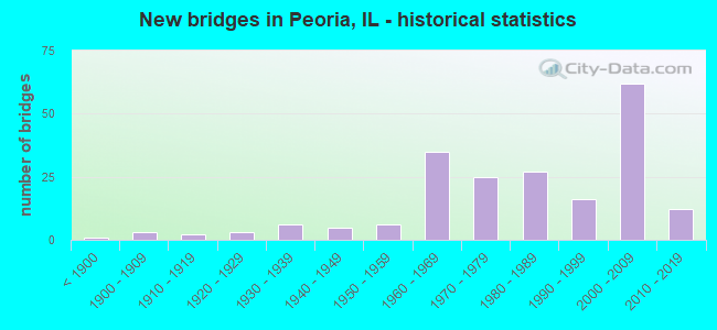
- New bridges - historical statistics
- 1Before 1900
- 31900-1909
- 21910-1919
- 31920-1929
- 61930-1939
- 51940-1949
- 61950-1959
- 351960-1969
- 251970-1979
- 271980-1989
- 161990-1999
- 622000-2009
- 122010-2019

- Reconstructed bridges - Historical Statistics
- 41970-1979
- 51980-1989
- 31990-1999
- 42000-2009
- 12010-2019


- Bridge Condition - Deck
- 5.8%Excellent
- 1.9%Very good
- 40.4%Good
- 36.5%Satisfactory
- 9.6%Fair
- 3.8%Poor
- 1.9%Serious
- 1.0%Critical

- Bridge Condition - Superstructure
- 11.1%Excellent
- 13.9%Very good
- 22.2%Good
- 22.2%Satisfactory
- 19.4%Fair
- 9.3%Poor
- 1.9%Serious
- 0.9%Critical

- Bridge Condition - Substructure
- 0.9%Excellent
- 13.9%Very good
- 30.6%Good
- 21.3%Satisfactory
- 23.1%Fair
- 8.3%Poor
- 1.9%Serious

- Bridge Condition - Channel
- 17.6%Very good
- 19.8%Good
- 28.6%Satisfactory
- 16.5%Fair
- 11.0%Poor
- 6.6%Serious

- Bridge Condition - Culverts
- 2.7%Very good
- 32.4%Good
- 29.7%Satisfactory
- 21.6%Fair
- 8.1%Poor
- 5.4%Serious
Find on map >> Show street view
Structure Number: 720141, Location: 0.7 MI N OF US 150 (Lat: 40.783042, Lng: -89.666397), Route carried "on" structure: State highway 6, Year Built: 1981, Status: Open, Structure Length: 3.20m (10.50ft), Average Daily Traffic: 19,800 (year 2021), Truck Traffic: 8%, Average Future Daily Traffic: 13,647 (year 2032), Design Load: HS 20, Features Intersected: HOERR'S POND
Minimum Vertical Clearance: 30+ m (98+ ft), Kilometerpoint: 4.844, Lanes on structure: 2, Base Highway Network: Yes, Owner: State Highway Agency, Approaching Roadway Width: 12.8m (42.0ft), Material/Design: Prestressed concrete continuous, Design/Construction: Stringer/Multi-beam, Number Of Spans In Main Unit: 2, Length of Maximum Span: 15.2m (49.9ft), Curb-To-Curb Width: 12.2m (40.0ft), Out-to-Out Width: 13.2m (43.3ft)
Condition: Deck: Satisfactory, Superstructure: Serious, Substructure: Fair, Channel: Very good, Operating Rating: 43.4 metric tons, Method Used To Determine Operating Rating: Load Factor (LF) rating reported by rating factor (RF) method using MS18 loading, Inventory Rating: 26.2 metric tons, Method Used To Determine Inventory Rating: Load Factor (LF) rating reported by rating factor (RF) method using MS18 loading, Structural Evaluation: High priority of corrective action, Deck Geometry: Better than present minimum criteria, Waterway Adequacy: Superior to present desirable criteria, Approach Roadway Alignment: Equal to present desirable criteria, Designated Inspection Frequency: Every 12 months, Other Special Inspection Frequency: Every 12 months, Inspection Date: September 2021, Other Special Inspection Date: May 2021, Deck Structure Type: Concrete Cast-file-Place, Wearing Surface/Protective System: Wearing Surface: Other, Deck Protection: Epoxy Coated Reinforcing
Find on map >> Show street view
Structure Number: 720142, Location: 0.7 MI N OF US 150 (Lat: 40.783186, Lng: -89.666322), Route carried "on" structure: State highway 6, Year Built: 1981, Status: Open, Structure Length: 3.20m (10.50ft), Average Daily Traffic: 19,800 (year 2021), Truck Traffic: 8%, Average Future Daily Traffic: 13,647 (year 2032), Design Load: HS 20, Features Intersected: HOERR'S POND
Minimum Vertical Clearance: 30+ m (98+ ft), Kilometerpoint: 4.860, Lanes on structure: 2, Base Highway Network: Yes, Owner: State Highway Agency, Approaching Roadway Width: 12.8m (42.0ft), Material/Design: Prestressed concrete continuous, Design/Construction: Stringer/Multi-beam, Number Of Spans In Main Unit: 2, Length of Maximum Span: 15.2m (49.9ft), Curb-To-Curb Width: 12.3m (40.4ft), Out-to-Out Width: 13.2m (43.3ft)
Condition: Deck: Satisfactory, Superstructure: Serious, Substructure: Fair, Channel: Very good, Operating Rating: 42.8 metric tons, Method Used To Determine Operating Rating: Load Factor (LF) rating reported by rating factor (RF) method using MS18 loading, Inventory Rating: 25.6 metric tons, Method Used To Determine Inventory Rating: Load Factor (LF) rating reported by rating factor (RF) method using MS18 loading, Structural Evaluation: High priority of corrective action, Deck Geometry: Better than present minimum criteria, Waterway Adequacy: Superior to present desirable criteria, Approach Roadway Alignment: Equal to present desirable criteria, Designated Inspection Frequency: Every 12 months, Other Special Inspection Frequency: Every 12 months, Inspection Date: September 2021, Other Special Inspection Date: May 2021, Deck Structure Type: Concrete Cast-file-Place, Wearing Surface/Protective System: Wearing Surface: Other, Deck Protection: Epoxy Coated Reinforcing
Find on map >> Show street view
Structure Number: 720144, Location: CTR S1/2-36-T10NR7E (Lat: 40.801850, Lng: -89.649889), Route carried "on" structure: State highway 6, Year Built: 1982, Status: Open, Structure Length: 1.74m (5.71ft), Average Daily Traffic: 19,800 (year 2021), Truck Traffic: 8%, Average Future Daily Traffic: 13,647 (year 2032), Design Load: HS 20, Features Intersected: FAS387(CHR52)RADNOR
Minimum Vertical Clearance: 30+ m (98+ ft), Kilometerpoint: 7.306, Lanes on structure: 2, Lanes under structure: 2, Base Highway Network: Yes, Owner: State Highway Agency, Approaching Roadway Width: 7.3m (24.0ft), Material/Design: Prestressed concrete, Design/Construction: Stringer/Multi-beam, Number Of Spans In Main Unit: 1, Length of Maximum Span: 15.8m (51.8ft), Curb-To-Curb Width: 12.2m (40.0ft), Out-to-Out Width: 13.1m (43.0ft)
Condition: Deck: Satisfactory, Superstructure: Fair, Substructure: Fair, Operating Rating: 68.4 metric tons, Method Used To Determine Operating Rating: Load Factor (LF) rating reported by rating factor (RF) method using MS18 loading, Inventory Rating: 38.9 metric tons, Method Used To Determine Inventory Rating: Load Factor (LF) rating reported by rating factor (RF) method using MS18 loading, Structural Evaluation: Somewhat better than minimum adequacy, Deck Geometry: Better than present minimum criteria, Underclear: Somewhat better than minimum adequacy, Approach Roadway Alignment: Equal to present desirable criteria, Designated Inspection Frequency: Every 24 months, Inspection Date: April 2020, Deck Structure Type: Concrete Cast-file-Place, Wearing Surface/Protective System: Deck Protection: Epoxy Coated Reinforcing
Find on map >> Show street view
Structure Number: 720145, Location: CTR S-1/2-36-T10NR7E (Lat: 40.801839, Lng: -89.650100), Route carried "on" structure: State highway 6, Year Built: 1982, Status: Open, Structure Length: 1.74m (5.71ft), Average Daily Traffic: 19,800 (year 2021), Truck Traffic: 8%, Average Future Daily Traffic: 13,647 (year 2032), Design Load: HS 20, Features Intersected: FAS 387(CHR52)Radnor
Minimum Vertical Clearance: 30+ m (98+ ft), Kilometerpoint: 7.290, Lanes on structure: 2, Lanes under structure: 2, Base Highway Network: Yes, Owner: State Highway Agency, Approaching Roadway Width: 7.3m (24.0ft), Material/Design: Prestressed concrete, Design/Construction: Stringer/Multi-beam, Number Of Spans In Main Unit: 1, Length of Maximum Span: 15.8m (51.8ft), Curb-To-Curb Width: 12.2m (40.0ft), Out-to-Out Width: 13.1m (43.0ft)
Condition: Deck: Satisfactory, Superstructure: Fair, Substructure: Fair, Operating Rating: 68.4 metric tons, Method Used To Determine Operating Rating: Load Factor (LF) rating reported by rating factor (RF) method using MS18 loading, Inventory Rating: 38.9 metric tons, Method Used To Determine Inventory Rating: Load Factor (LF) rating reported by rating factor (RF) method using MS18 loading, Structural Evaluation: Somewhat better than minimum adequacy, Deck Geometry: Better than present minimum criteria, Underclear: Somewhat better than minimum adequacy, Approach Roadway Alignment: Equal to present desirable criteria, Designated Inspection Frequency: Every 24 months, Inspection Date: April 2020, Deck Structure Type: Concrete Cast-file-Place, Wearing Surface/Protective System: Deck Protection: Epoxy Coated Reinforcing
Find on map >> Show street view
Structure Number: 720146, Location: CTR-S1/2-31-T10NR8E (Lat: 40.801817, Lng: -89.631061), Route carried "on" structure: Other road , Year Built: 1982, Status: Open, Structure Length: 8.14m (26.71ft), Average Daily Traffic: 19,700 (year 2017), Truck Traffic: 6%, Average Future Daily Traffic: 19,222 (year 2032), Design Load: HS 20, Features Intersected: ILL 6, Facility Carried by Structure: FAU 6584-ALLEN RD
Minimum Vertical Clearance: 30+ m (98+ ft), Kilometerpoint: 1.545, Lanes on structure: 5, Lanes under structure: 6, Base Highway Network: Yes, Owner: State Highway Agency, Approaching Roadway Width: 14.6m (47.9ft), Skew: 30 degrees, Material/Design: Steel continuous, Design/Construction: Stringer/Multi-beam, Number Of Spans In Main Unit: 2, Number Of Approach Spans: 2, Length of Maximum Span: 33.4m (109.6ft), Curb or Sidewalk Widths: Left: 0.0m, Right: 4.0m (13.1ft), Curb-To-Curb Width: 20.1m (65.9ft), Out-to-Out Width: 26.6m (87.3ft)
Condition: Deck: Satisfactory, Superstructure: Satisfactory, Substructure: Good, Operating Rating: 74.5 metric tons, Method Used To Determine Operating Rating: Load Factor (LF) rating reported by rating factor (RF) method using MS18 loading, Inventory Rating: 44.4 metric tons, Method Used To Determine Inventory Rating: Load Factor (LF) rating reported by rating factor (RF) method using MS18 loading, Structural Evaluation: Equal to present minimum criteria, Deck Geometry: Somewhat better than minimum adequacy, Underclear: Somewhat better than minimum adequacy, Approach Roadway Alignment: Equal to present minimum criteria, Designated Inspection Frequency: Every 24 months, Inspection Date: May 2020, Deck Structure Type: Concrete Cast-file-Place, Wearing Surface/Protective System: Deck Protection: Epoxy Coated Reinforcing
Find on map >> Show street view
Structure Number: 720147, Location: CTR-32-T10NR8E (Lat: 40.805814, Lng: -89.612758), Route carried "on" structure: State highway 40, Year Built: 1982, Status: Open, Structure Length: 7.68m (25.20ft), Average Daily Traffic: 17,200 (year 2021), Truck Traffic: 4%, Average Future Daily Traffic: 20,072 (year 2032), Design Load: HS 20, Features Intersected: IL 6
Minimum Vertical Clearance: 30+ m (98+ ft), Kilometerpoint: 15.868, Lanes on structure: 5, Lanes under structure: 6, Base Highway Network: Yes, Owner: State Highway Agency, Approaching Roadway Width: 21.9m (71.9ft), Skew: 30 degrees, Material/Design: Steel continuous, Design/Construction: Stringer/Multi-beam, Number Of Spans In Main Unit: 2, Number Of Approach Spans: 2, Length of Maximum Span: 39.9m (130.9ft), Curb-To-Curb Width: 26.3m (86.3ft), Out-to-Out Width: 32.8m (107.6ft)
Condition: Deck: Fair, Superstructure: Poor, Substructure: Poor, Operating Rating: 61.2 metric tons, Method Used To Determine Operating Rating: Load Factor (LF) rating reported by rating factor (RF) method using MS18 loading, Inventory Rating: 36.6 metric tons, Method Used To Determine Inventory Rating: Load Factor (LF) rating reported by rating factor (RF) method using MS18 loading, Structural Evaluation: Meets minimum limits, Deck Geometry: Superior to present desirable criteria, Underclear: Equal to present minimum criteria, Approach Roadway Alignment: Equal to present minimum criteria, Designated Inspection Frequency: Every 12 months, Inspection Date: May 2021, Deck Structure Type: Concrete Cast-file-Place, Wearing Surface/Protective System: Deck Protection: Epoxy Coated Reinforcing
Find on map >> Show street view
Structure Number: 720148, Location: .35M W OF ILL 29 (Lat: 40.817039, Lng: -89.573339), Route carried "on" structure: Other road , Year Built: 1984, Status: Open, Structure Length: 6.74m (22.11ft), Average Daily Traffic: 3,150 (year 2020), Truck Traffic: 3%, Average Future Daily Traffic: 2,602 (year 2032), Design Load: HS 20, Features Intersected: ILL 6, Facility Carried by Structure: MOSSVILLE RD-CH D3
Minimum Vertical Clearance: 30+ m (98+ ft), Kilometerpoint: 3.862, Lanes on structure: 2, Lanes under structure: 4, Owner: State Highway Agency, Approaching Roadway Width: 7.9m (25.9ft), Skew: 2 degrees, Material/Design: Steel continuous, Design/Construction: Stringer/Multi-beam, Number Of Spans In Main Unit: 2, Number Of Approach Spans: 2, Length of Maximum Span: 35.7m (117.1ft), Curb or Sidewalk Widths: Left: 1.5m (4.9ft), Right: 1.5m (4.9ft), Curb-To-Curb Width: 8.7m (28.5ft), Out-to-Out Width: 12.4m (40.7ft)
Condition: Deck: Fair, Superstructure: Serious, Substructure: Satisfactory, Operating Rating: 61.6 metric tons, Method Used To Determine Operating Rating: Load Factor (LF) rating reported by rating factor (RF) method using MS18 loading, Inventory Rating: 36.6 metric tons, Method Used To Determine Inventory Rating: Load Factor (LF) rating reported by rating factor (RF) method using MS18 loading, Structural Evaluation: High priority of corrective action, Deck Geometry: Meets minimum limits, Underclear: Better than present minimum criteria, Approach Roadway Alignment: Equal to present minimum criteria, Designated Inspection Frequency: Every 12 months, Inspection Date: January 2021, Deck Structure Type: Concrete Cast-file-Place, Wearing Surface/Protective System: Deck Protection: Epoxy Coated Reinforcing
Find on map >> Show street view
Structure Number: 720149, Location: 0.4 MI W OF MOSSVILL (Lat: 40.825489, Lng: -89.573953), Route carried "on" structure: State highway 6, Year Built: 1983, Status: Open, Structure Length: 9.05m (29.69ft), Average Daily Traffic: 4,750 (year 2021), Truck Traffic: 9%, Average Future Daily Traffic: 17,629 (year 2032), Design Load: HS 20, Features Intersected: ILL 6 & RAMP, Facility Carried by Structure: ILL 29 SPUR
Minimum Vertical Clearance: 30+ m (98+ ft), Kilometerpoint: 15.610, Lanes on structure: 4, Base Highway Network: Yes, Owner: State Highway Agency, Approaching Roadway Width: 18.3m (60.0ft), Skew: 31 degrees, Material/Design: Steel continuous, Design/Construction: Stringer/Multi-beam, Number Of Spans In Main Unit: 2, Length of Maximum Span: 39.0m (128.0ft), Curb-To-Curb Width: 18.3m (60.0ft), Out-to-Out Width: 19.2m (63.0ft)
Condition: Deck: Fair, Superstructure: Fair, Substructure: Fair, Operating Rating: 71.3 metric tons, Method Used To Determine Operating Rating: Load Factor (LF) rating reported by rating factor (RF) method using MS18 loading, Inventory Rating: 42.8 metric tons, Method Used To Determine Inventory Rating: Load Factor (LF) rating reported by rating factor (RF) method using MS18 loading, Structural Evaluation: Somewhat better than minimum adequacy, Deck Geometry: Meets minimum limits, Approach Roadway Alignment: Equal to present minimum criteria, Designated Inspection Frequency: Every 24 months, Inspection Date: January 2020, Deck Structure Type: Concrete Cast-file-Place, Wearing Surface/Protective System: Deck Protection: Epoxy Coated Reinforcing
Find on map >> Show street view
Structure Number: 720154, Location: 1.3MI E. IL6 & US150 (Lat: 40.769108, Lng: -89.649633), Route carried "on" structure: US 150, Year Built: 1988, Status: Open, Structure Length: 5.15m (16.90ft), Average Daily Traffic: 18,700 (year 2021), Truck Traffic: 2%, Average Future Daily Traffic: 22,514 (year 2032), Design Load: HS 20, Features Intersected: UPRR 175626N-MP73.04
Minimum Vertical Clearance: 30+ m (98+ ft), Kilometerpoint: 132.639, Lanes on structure: 4, Base Highway Network: Yes, Owner: State Highway Agency, Approaching Roadway Width: 25.0m (82.0ft), Skew: 22 degrees, Material/Design: Steel continuous, Design/Construction: Stringer/Multi-beam, Number Of Spans In Main Unit: 3, Length of Maximum Span: 19.8m (65.0ft), Curb-To-Curb Width: 25.0m (82.0ft), Out-to-Out Width: 26.0m (85.3ft)
Condition: Deck: Fair, Superstructure: Poor, Substructure: Poor, Operating Rating: 56.1 metric tons, Method Used To Determine Operating Rating: Load Factor (LF) rating reported by rating factor (RF) method using MS18 loading, Inventory Rating: 33.7 metric tons, Method Used To Determine Inventory Rating: Load Factor (LF) rating reported by rating factor (RF) method using MS18 loading, Structural Evaluation: Meets minimum limits, Deck Geometry: Superior to present desirable criteria, Underclear: Equal to present desirable criteria, Approach Roadway Alignment: Equal to present desirable criteria, Designated Inspection Frequency: Every 12 months, Inspection Date: April 2021, Deck Structure Type: Concrete Cast-file-Place, Wearing Surface/Protective System: Deck Protection: Epoxy Coated Reinforcing
Find on map >> Show street view
Structure Number: 720156, Location: 3.5 MI NW POTTSTOWN (Lat: 40.741469, Lng: -89.705881), Route carried "on" structure: State highway 8, Year Built: 1991, Status: Open, Structure Length: 1.30m (4.27ft), Average Daily Traffic: 2,550 (year 2021), Truck Traffic: 6%, Average Future Daily Traffic: 2,549 (year 2032), Design Load: HS 20, Features Intersected: TRIB OF KICKAPOO CR
Minimum Vertical Clearance: 30+ m (98+ ft), Kilometerpoint: 40.828, Lanes on structure: 2, Owner: State Highway Agency, Approaching Roadway Width: 7.9m (25.9ft), Material/Design: Prestressed concrete, Design/Construction: Box Beam or Girders - Multiple, Number Of Spans In Main Unit: 1, Length of Maximum Span: 12.3m (40.4ft), Curb-To-Curb Width: 9.8m (32.2ft), Out-to-Out Width: 9.8m (32.2ft)
Condition: Deck: Fair, Superstructure: Fair, Substructure: Good, Channel: Satisfactory, Operating Rating: 57.7 metric tons, Method Used To Determine Operating Rating: Load Factor (LF) rating reported by rating factor (RF) method using MS18 loading, Inventory Rating: 36.0 metric tons, Method Used To Determine Inventory Rating: Load Factor (LF) rating reported by rating factor (RF) method using MS18 loading, Structural Evaluation: Somewhat better than minimum adequacy, Deck Geometry: Meets minimum limits, Waterway Adequacy: Equal to present minimum criteria, Approach Roadway Alignment: Equal to present desirable criteria, Designated Inspection Frequency: Every 24 months, Inspection Date: Febuary 2020, Deck Structure Type: Concrete Precast Panels, Wearing Surface/Protective System: Wearing Surface: Bituminous, Membrane: Built-up
Find on map >> Show street view
Structure Number: 720158, Location: 1 MI NW OF POTTSTOWN (Lat: 40.733539, Lng: -89.675697), Route carried "on" structure: State highway 8, Year Built: 1991, Status: Open, Structure Length: 1.56m (5.12ft), Average Daily Traffic: 2,750 (year 2021), Truck Traffic: 5%, Average Future Daily Traffic: 3,345 (year 2032), Design Load: HS 20, Features Intersected: TRIB KICKAPOO CR
Minimum Vertical Clearance: 30+ m (98+ ft), Kilometerpoint: 43.548, Lanes on structure: 2, Owner: State Highway Agency, Approaching Roadway Width: 7.9m (25.9ft), Material/Design: Prestressed concrete, Design/Construction: Box Beam or Girders - Multiple, Number Of Spans In Main Unit: 1, Length of Maximum Span: 15.0m (49.2ft), Curb-To-Curb Width: 9.8m (32.2ft), Out-to-Out Width: 9.8m (32.2ft)
Condition: Deck: Poor, Superstructure: Poor, Substructure: Good, Channel: Fair, Operating Rating: 53.1 metric tons, Method Used To Determine Operating Rating: Load Factor (LF) rating reported by rating factor (RF) method using MS18 loading, Inventory Rating: 31.8 metric tons, Method Used To Determine Inventory Rating: Load Factor (LF) rating reported by rating factor (RF) method using MS18 loading, Structural Evaluation: Meets minimum limits, Deck Geometry: Meets minimum limits, Waterway Adequacy: Meets minimum limits, Approach Roadway Alignment: Equal to present desirable criteria, Designated Inspection Frequency: Every 12 months, Inspection Date: Febuary 2021, Deck Structure Type: Concrete Precast Panels, Wearing Surface/Protective System: Wearing Surface: Bituminous, Membrane: Built-up
Find on map >> Show street view
Structure Number: 720159, Location: IN POTTSTOWN (Lat: 40.717561, Lng: -89.659811), Route carried "on" structure: State highway 8, Year Built: 1991, Status: Posted for load, Structure Length: 2.23m (7.32ft), Average Daily Traffic: 1,800 (year 2021), Truck Traffic: 8%, Average Future Daily Traffic: 2,390 (year 2032), Design Load: HS 20, Features Intersected: TRIB OF KICKAPOO CR
Minimum Vertical Clearance: 30+ m (98+ ft), Kilometerpoint: 46.187, Lanes on structure: 2, Owner: State Highway Agency, Approaching Roadway Width: 7.9m (25.9ft), Material/Design: Prestressed concrete, Design/Construction: Box Beam or Girders - Multiple, Number Of Spans In Main Unit: 2, Length of Maximum Span: 12.8m (42.0ft), Curb-To-Curb Width: 9.8m (32.2ft), Out-to-Out Width: 12.5m (41.0ft)
Condition: Deck: Poor, Superstructure: Poor, Substructure: Fair, Channel: Serious, Operating Rating: 42.1 metric tons, Method Used To Determine Operating Rating: Load Factor (LF) rating reported by rating factor (RF) method using MS18 loading, Inventory Rating: 25.3 metric tons, Method Used To Determine Inventory Rating: Load Factor (LF) rating reported by rating factor (RF) method using MS18 loading, Structural Evaluation: Meets minimum limits, Deck Geometry: Somewhat better than minimum adequacy, Waterway Adequacy: Somewhat better than minimum adequacy, Approach Roadway Alignment: Equal to present minimum criteria, Bridge Posting: Required (Relationship of Operating Rating to Maximum Legal Load: 30.0 - 39.9% below), Designated Inspection Frequency: Every 12 months, Inspection Date: Febuary 2021, Deck Structure Type: Concrete Precast Panels, Wearing Surface/Protective System: Wearing Surface: Bituminous, Membrane: Built-up
Find on map >> Show street view
Structure Number: 720161, Location: 1 MI N OF US 150 (Lat: 40.786219, Lng: -89.669606), Route carried "on" structure: State highway 91, Year Built: 1995, Status: Open, Structure Length: 1.65m (5.41ft), Average Daily Traffic: 7,250 (year 2021), Truck Traffic: 6%, Average Future Daily Traffic: 10,514 (year 2032), Design Load: HS 20, Features Intersected: FARGO RUN
Minimum Vertical Clearance: 30+ m (98+ ft), Kilometerpoint: 1.271, Lanes on structure: 2, Base Highway Network: Yes, Owner: State Highway Agency, Approaching Roadway Width: 9.8m (32.2ft), Material/Design: Steel, Design/Construction: Stringer/Multi-beam, Number Of Spans In Main Unit: 1, Length of Maximum Span: 16.5m (54.1ft), Curb-To-Curb Width: 9.8m (32.2ft), Out-to-Out Width: 10.7m (35.1ft)
Condition: Deck: Satisfactory, Superstructure: Very good, Substructure: Satisfactory, Channel: Poor, Operating Rating: 85.5 metric tons, Method Used To Determine Operating Rating: Load Factor (LF) rating reported by rating factor (RF) method using MS18 loading, Inventory Rating: 51.5 metric tons, Method Used To Determine Inventory Rating: Load Factor (LF) rating reported by rating factor (RF) method using MS18 loading, Structural Evaluation: Equal to present minimum criteria, Deck Geometry: Meets minimum limits, Waterway Adequacy: Equal to present minimum criteria, Approach Roadway Alignment: Equal to present desirable criteria, Designated Inspection Frequency: Every 24 months, Inspection Date: Febuary 2020, Deck Structure Type: Concrete Cast-file-Place, Wearing Surface/Protective System: Deck Protection: Epoxy Coated Reinforcing
Find on map >> Show street view
Structure Number: 720167, Location: NE C.L PEORIA (Lat: 40.723069, Lng: -89.555639), Route carried "on" structure: US 150, Year Built: 1995, Status: Open, Structure Length: 6.08m (19.95ft), Average Daily Traffic: 25,800 (year 2021), Truck Traffic: 4%, Average Future Daily Traffic: 16,302 (year 2032), Design Load: HS 20, Features Intersected: IL 29 NE ADAMS ST
Minimum Vertical Clearance: 30+ m (98+ ft), Kilometerpoint: 143.115, Lanes on structure: 2, Lanes under structure: 4, Base Highway Network: Yes, Owner: State Highway Agency, Approaching Roadway Width: 9.2m (30.2ft), Material/Design: Steel continuous, Design/Construction: Stringer/Multi-beam, Number Of Spans In Main Unit: 4, Length of Maximum Span: 18.3m (60.0ft), Curb-To-Curb Width: 9.2m (30.2ft), Out-to-Out Width: 10.2m (33.5ft)
Condition: Deck: Satisfactory, Superstructure: Satisfactory, Substructure: Good, Operating Rating: 89.1 metric tons, Method Used To Determine Operating Rating: Load Factor (LF) rating reported by rating factor (RF) method using MS18 loading, Inventory Rating: 55.7 metric tons, Method Used To Determine Inventory Rating: Load Factor (LF) rating reported by rating factor (RF) method using MS18 loading, Structural Evaluation: Equal to present minimum criteria, Deck Geometry: Meets minimum limits, Underclear: Meets minimum limits, Approach Roadway Alignment: Equal to present minimum criteria, Designated Inspection Frequency: Every 24 months, Inspection Date: Febuary 2020, Deck Structure Type: Concrete Cast-file-Place, Wearing Surface/Protective System: Deck Protection: Epoxy Coated Reinforcing
Find on map >> Show street view
Structure Number: 720168, Location: IL 29 NE ADAMS ST (Lat: 40.723028, Lng: -89.555514), Route carried "on" structure: US 150, Year Built: 1995, Status: Open, Structure Length: 6.09m (19.98ft), Average Daily Traffic: 30,000 (year 2021), Truck Traffic: 3%, Average Future Daily Traffic: 16,302 (year 2032), Design Load: HS 20, Features Intersected: IL 29
Minimum Vertical Clearance: 30+ m (98+ ft), Kilometerpoint: 143.131, Lanes on structure: 2, Lanes under structure: 4, Base Highway Network: Yes, Owner: State Highway Agency, Approaching Roadway Width: 9.1m (29.9ft), Material/Design: Steel continuous, Design/Construction: Stringer/Multi-beam, Number Of Spans In Main Unit: 4, Length of Maximum Span: 18.3m (60.0ft), Curb-To-Curb Width: 20.0m (65.6ft), Out-to-Out Width: 20.8m (68.2ft)
Condition: Deck: Serious, Superstructure: Fair, Substructure: Satisfactory, Operating Rating: 36.9 metric tons, Method Used To Determine Operating Rating: Load Factor (LF) rating reported by rating factor (RF) method using MS18 loading, Inventory Rating: 22.0 metric tons, Method Used To Determine Inventory Rating: Load Factor (LF) rating reported by rating factor (RF) method using MS18 loading, Structural Evaluation: Somewhat better than minimum adequacy, Deck Geometry: Superior to present desirable criteria, Underclear: Meets minimum limits, Approach Roadway Alignment: Equal to present minimum criteria, Designated Inspection Frequency: Every 24 months, Inspection Date: Febuary 2020, Deck Structure Type: Concrete Cast-file-Place, Wearing Surface/Protective System: Deck Protection: Epoxy Coated Reinforcing
Find on map >> Show street view
Structure Number: 720169, Location: POTTSTOWN (Lat: 40.724317, Lng: -89.663325), Route carried "on" structure: State highway 8, Year Built: 2000, Status: Open, Structure Length: 9.64m (31.63ft), Average Daily Traffic: 3,100 (year 2021), Truck Traffic: 4%, Average Future Daily Traffic: 3,929 (year 2032), Design Load: HS 20, Features Intersected: UP RR
Minimum Vertical Clearance: 30+ m (98+ ft), Kilometerpoint: 45.350, Lanes on structure: 2, Owner: State Highway Agency, Approaching Roadway Width: 9.1m (29.9ft), Skew: 3 degrees, Material/Design: Steel continuous, Design/Construction: Stringer/Multi-beam, Number Of Spans In Main Unit: 3, Length of Maximum Span: 37.8m (124.0ft), Curb-To-Curb Width: 11.0m (36.1ft), Out-to-Out Width: 11.9m (39.0ft)
Condition: Deck: Satisfactory, Superstructure: Satisfactory, Substructure: Good, Operating Rating: 70.3 metric tons, Method Used To Determine Operating Rating: Load Factor (LF) rating reported by rating factor (RF) method using MS18 loading, Inventory Rating: 42.4 metric tons, Method Used To Determine Inventory Rating: Load Factor (LF) rating reported by rating factor (RF) method using MS18 loading, Structural Evaluation: Equal to present minimum criteria, Deck Geometry: Somewhat better than minimum adequacy, Underclear: Equal to present desirable criteria, Approach Roadway Alignment: Equal to present minimum criteria, Designated Inspection Frequency: Every 24 months, Inspection Date: June 2020, Deck Structure Type: Concrete Cast-file-Place, Wearing Surface/Protective System: Deck Protection: Epoxy Coated Reinforcing
Find on map >> Show street view
Structure Number: 720172, Location: US 150/I74 INTERCHAN (Lat: 40.736417, Lng: -89.625575), Route carried "on" structure: Other road , Year Built: 2006, Status: Open, Structure Length: 3.59m (11.78ft), Average Daily Traffic: 2,600 (year 2017), Truck Traffic: 5%, Average Future Daily Traffic: 2,921 (year 2032), Design Load: HS 20, Features Intersected: I 74 RP 20.63, Facility Carried by Structure: I 74 RP 21.16
Minimum Vertical Clearance: 30+ m (98+ ft), Kilometerpoint: 0.370, Lanes on structure: 1, Lanes under structure: 1, Base Highway Network: Yes (Inventory Route: 10074042, Subroute: 60), Owner: State Highway Agency, Approaching Roadway Width: 7.9m (25.9ft), Skew: 4 degrees, Material/Design: Steel, Design/Construction: Stringer/Multi-beam, Number Of Spans In Main Unit: 1, Length of Maximum Span: 32.5m (106.6ft), Curb-To-Curb Width: 7.9m (25.9ft), Out-to-Out Width: 9.0m (29.5ft)
Condition: Deck: Satisfactory, Superstructure: Good, Substructure: Very good, Operating Rating: 89.1 metric tons, Method Used To Determine Operating Rating: Load Factor (LF) rating reported by rating factor (RF) method using MS18 loading, Inventory Rating: 54.8 metric tons, Method Used To Determine Inventory Rating: Load Factor (LF) rating reported by rating factor (RF) method using MS18 loading, Structural Evaluation: Better than present minimum criteria, Deck Geometry: High priority of corrective action, Underclear: High priority of corrective action, Approach Roadway Alignment: Equal to present minimum criteria, Designated Inspection Frequency: Every 24 months, Inspection Date: June 2021, Deck Structure Type: Concrete Cast-file-Place, Wearing Surface/Protective System: Deck Protection: Epoxy Coated Reinforcing
Find on map >> Show street view
Structure Number: 720174, Location: 1.25 MI W ILLINOIS R (Lat: 40.704517, Lng: -89.596403), Route carried "on" structure: Other road , Year Built: 2005, Status: Open, Structure Length: 9.46m (31.04ft), Average Daily Traffic: 2,750 (year 2021), Truck Traffic: 1%, Average Future Daily Traffic: 2,761 (year 2032), Design Load: HS 20, Features Intersected: I-74,RPF-1,RP F-6, Facility Carried by Structure: EB74 TO IL 40 NBSB
Minimum Vertical Clearance: 30+ m (98+ ft), Kilometerpoint: 0.563, Lanes on structure: 1, Lanes under structure: 6, Base Highway Network: Yes (Inventory Route: 10074042, Subroute: 20), Owner: State Highway Agency, Approaching Roadway Width: 10.6m (34.8ft), Skew: 2 degrees, Material/Design: Steel continuous, Design/Construction: Stringer/Multi-beam, Number Of Spans In Main Unit: 3, Number Of Approach Spans: 1, Length of Maximum Span: 37.5m (123.0ft), Curb-To-Curb Width: 10.6m (34.8ft), Out-to-Out Width: 11.6m (38.1ft)
Condition: Deck: Fair, Superstructure: Good, Substructure: Satisfactory, Operating Rating: 72.9 metric tons, Method Used To Determine Operating Rating: Load Factor (LF) rating reported by rating factor (RF) method using MS18 loading, Inventory Rating: 45.4 metric tons, Method Used To Determine Inventory Rating: Load Factor (LF) rating reported by rating factor (RF) method using MS18 loading, Structural Evaluation: Equal to present minimum criteria, Deck Geometry: Somewhat better than minimum adequacy, Underclear: High priority of corrective action, Approach Roadway Alignment: Equal to present minimum criteria, Designated Inspection Frequency: Every 24 months, Inspection Date: April 2020, Deck Structure Type: Concrete Cast-file-Place, Wearing Surface/Protective System: Deck Protection: Epoxy Coated Reinforcing
Find on map >> Show street view
Structure Number: 720175, Location: 1.25 MI W ILL RIVER (Lat: 40.703242, Lng: -89.594733), Route carried "on" structure: Other road , Year Built: 2005, Status: Open, Structure Length: 10.91m (35.79ft), Average Daily Traffic: 18,900 (year 2017), Truck Traffic: 3%, Average Future Daily Traffic: 21,028 (year 2032), Design Load: HS 20, Features Intersected: I-74 AND RP F-6, Facility Carried by Structure: SB KNOXVILLE,RPF-2
Minimum Vertical Clearance: 30+ m (98+ ft), Kilometerpoint: 0.016, Lanes on structure: 3, Lanes under structure: 5, Base Highway Network: Yes (Inventory Route: 10074042, Subroute: 90), Owner: State Highway Agency, Approaching Roadway Width: 13.6m (44.6ft), Material/Design: Steel continuous, Design/Construction: Stringer/Multi-beam, Number Of Spans In Main Unit: 2, Length of Maximum Span: 60.3m (197.8ft), Curb-To-Curb Width: 13.6m (44.6ft), Out-to-Out Width: 14.8m (48.6ft)
Condition: Deck: Satisfactory, Superstructure: Good, Substructure: Good, Operating Rating: 77.1 metric tons, Method Used To Determine Operating Rating: Load Factor (LF) rating reported by rating factor (RF) method using MS18 loading, Inventory Rating: 46.3 metric tons, Method Used To Determine Inventory Rating: Load Factor (LF) rating reported by rating factor (RF) method using MS18 loading, Structural Evaluation: Better than present minimum criteria, Deck Geometry: Meets minimum limits, Underclear: Meets minimum limits, Approach Roadway Alignment: Equal to present minimum criteria, Designated Inspection Frequency: Every 24 months, Inspection Date: May 2020, Deck Structure Type: Concrete Cast-file-Place, Wearing Surface/Protective System: Deck Protection: Epoxy Coated Reinforcing
Find on map >> Show street view
Structure Number: 720176, Location: 0.75 MI W ILL RIVER (Lat: 40.702897, Lng: -89.593711), Route carried "on" structure: Other road , Year Built: 2006, Status: Open, Structure Length: 6.40m (21.00ft), Average Daily Traffic: 10,400 (year 2017), Truck Traffic: 3%, Average Future Daily Traffic: 11,363 (year 2032), Design Load: HS 20, Features Intersected: FAI 74 RP 24.11, Facility Carried by Structure: NB KNOXVILLE
Minimum Vertical Clearance: 30+ m (98+ ft), Kilometerpoint: 0.402, Lanes on structure: 5, Lanes under structure: 2, Base Highway Network: Yes, Owner: State Highway Agency, Approaching Roadway Width: 14.3m (46.9ft), Skew: 7 degrees, Material/Design: Prestressed concrete, Design/Construction: Box Beam or Girders - Multiple, Number Of Spans In Main Unit: 1, Length of Maximum Span: 64.0m (210.0ft), Curb-To-Curb Width: 14.3m (46.9ft), Out-to-Out Width: 14.3m (46.9ft)
Condition: Deck: Very good, Superstructure: Very good, Substructure: Good, Operating Rating: 89.1 metric tons, Method Used To Determine Operating Rating: Load Factor (LF) rating reported by rating factor (RF) method using MS18 loading, Inventory Rating: 54.8 metric tons, Method Used To Determine Inventory Rating: Load Factor (LF) rating reported by rating factor (RF) method using MS18 loading, Structural Evaluation: Better than present minimum criteria, Deck Geometry: High priority of replacement, Underclear: High priority of corrective action, Approach Roadway Alignment: Equal to present minimum criteria, Designated Inspection Frequency: Every 24 months, Inspection Date: April 2021, Deck Structure Type: Concrete Precast Panels, Wearing Surface/Protective System: Wearing Surface: Other, Membrane: Built-up, Deck Protection: Epoxy Coated Reinforcing
Find on map >> Show street view
Structure Number: 720177, Location: .75 MI W ILLINOIS R (Lat: 40.700533, Lng: -89.593439), Route carried "on" structure: Interstate 74, Year Built: 2006, Status: Open, Structure Length: 2.63m (8.63ft), Average Daily Traffic: 32,800 (year 2021), Truck Traffic: 6%, Average Future Daily Traffic: 36,108 (year 2032), Design Load: HS 20, Features Intersected: GLEN OAK AVE
Minimum Vertical Clearance: 30+ m (98+ ft), Kilometerpoint: 152.095, Lanes on structure: 5, Lanes under structure: 4, Base Highway Network: Yes, Owner: State Highway Agency, Approaching Roadway Width: 21.3m (69.9ft), Material/Design: Steel, Design/Construction: Stringer/Multi-beam, Number Of Spans In Main Unit: 1, Length of Maximum Span: 23.3m (76.4ft), Curb-To-Curb Width: 21.3m (69.9ft), Out-to-Out Width: 21.6m (70.9ft)
Condition: Deck: Satisfactory, Superstructure: Good, Substructure: Good, Operating Rating: 74.8 metric tons, Method Used To Determine Operating Rating: Load Factor (LF) rating reported by rating factor (RF) method using MS18 loading, Inventory Rating: 45.0 metric tons, Method Used To Determine Inventory Rating: Load Factor (LF) rating reported by rating factor (RF) method using MS18 loading, Structural Evaluation: Better than present minimum criteria, Deck Geometry: Meets minimum limits, Underclear: Meets minimum limits, Approach Roadway Alignment: Equal to present minimum criteria, Designated Inspection Frequency: Every 24 months, Inspection Date: April 2021, Deck Structure Type: Concrete Cast-file-Place, Wearing Surface/Protective System: Deck Protection: Epoxy Coated Reinforcing
Find on map >> Show street view
Structure Number: 720178, Location: .75 MI W ILLINOIS R (Lat: 40.700319, Lng: -89.593275), Route carried "on" structure: Interstate 74, Year Built: 2006, Status: Open, Structure Length: 2.63m (8.63ft), Average Daily Traffic: 25,000 (year 2021), Truck Traffic: 6%, Average Future Daily Traffic: 27,718 (year 2032), Design Load: HS 20, Features Intersected: GLEN OAK AVE
Minimum Vertical Clearance: 30+ m (98+ ft), Kilometerpoint: 152.127, Lanes on structure: 3, Lanes under structure: 4, Base Highway Network: Yes, Owner: State Highway Agency, Approaching Roadway Width: 21.3m (69.9ft), Material/Design: Steel continuous, Design/Construction: Stringer/Multi-beam, Number Of Spans In Main Unit: 1, Length of Maximum Span: 23.3m (76.4ft), Curb-To-Curb Width: 21.3m (69.9ft), Out-to-Out Width: 21.6m (70.9ft)
Condition: Deck: Satisfactory, Superstructure: Good, Substructure: Very good, Operating Rating: 71.6 metric tons, Method Used To Determine Operating Rating: Load Factor (LF) rating reported by rating factor (RF) method using MS18 loading, Inventory Rating: 43.1 metric tons, Method Used To Determine Inventory Rating: Load Factor (LF) rating reported by rating factor (RF) method using MS18 loading, Structural Evaluation: Better than present minimum criteria, Deck Geometry: Superior to present desirable criteria, Underclear: Meets minimum limits, Approach Roadway Alignment: Equal to present minimum criteria, Designated Inspection Frequency: Every 24 months, Inspection Date: April 2021, Deck Structure Type: Concrete Cast-file-Place, Wearing Surface/Protective System: Deck Protection: Epoxy Coated Reinforcing
Find on map >> Show street view
Structure Number: 720179, Location: SB US24 IN PEORIA (Lat: 40.694717, Lng: -89.587472), Route carried "on" structure: Other road , Year Built: 2005, Status: Open, Structure Length: 4.88m (16.01ft), Average Daily Traffic: 8,810 (year 2021), Truck Traffic: 5%, Average Future Daily Traffic: 14,549 (year 2032), Design Load: HS 20, Features Intersected: I-74, Facility Carried by Structure: JEFFERSON ST-US 24
Minimum Vertical Clearance: 30+ m (98+ ft), Kilometerpoint: 15.996, Lanes on structure: 4, Lanes under structure: 7, Base Highway Network: Yes, Owner: State Highway Agency, Approaching Roadway Width: 15.6m (51.2ft), Material/Design: Steel continuous, Design/Construction: Stringer/Multi-beam, Number Of Spans In Main Unit: 2, Length of Maximum Span: 27.0m (88.6ft), Curb or Sidewalk Widths: Left: 1.8m (5.9ft), Right: 1.8m (5.9ft), Curb-To-Curb Width: 15.6m (51.2ft), Out-to-Out Width: 20.3m (66.6ft)
Condition: Deck: Fair, Superstructure: Fair, Substructure: Good, Operating Rating: 89.1 metric tons, Method Used To Determine Operating Rating: Load Factor (LF) rating reported by rating factor (RF) method using MS18 loading, Inventory Rating: 53.5 metric tons, Method Used To Determine Inventory Rating: Load Factor (LF) rating reported by rating factor (RF) method using MS18 loading, Structural Evaluation: Somewhat better than minimum adequacy, Deck Geometry: Meets minimum limits, Underclear: High priority of corrective action, Approach Roadway Alignment: Equal to present desirable criteria, Designated Inspection Frequency: Every 24 months, Inspection Date: October 2020, Deck Structure Type: Concrete Cast-file-Place, Wearing Surface/Protective System: Deck Protection: Epoxy Coated Reinforcing
Find on map >> Show street view
Structure Number: 72018, Location: DOWNTOWN PEORIA (Lat: 40.693933, Lng: -89.587214), Route carried "on" structure: Other road , Year Built: 2006, Status: Open, Structure Length: 2.81m (9.22ft), Average Daily Traffic: 6,700 (year 2017), Truck Traffic: 8%, Average Future Daily Traffic: 7,115 (year 2032), Design Load: HS 20, Features Intersected: 74EB TO WASHINGTON, Facility Carried by Structure: FAYETTE RP TO 74EB
Minimum Vertical Clearance: 30+ m (98+ ft), Kilometerpoint: 0.048, Lanes on structure: 1, Lanes under structure: 2, Base Highway Network: Yes (Inventory Route: 10074042, Subroute: 60), Owner: State Highway Agency, Approaching Roadway Width: 7.9m (25.9ft), Skew: 4 degrees, Material/Design: Prestressed concrete, Design/Construction: Stringer/Multi-beam, Number Of Spans In Main Unit: 1, Length of Maximum Span: 25.4m (83.3ft), Curb-To-Curb Width: 7.9m (25.9ft), Out-to-Out Width: 9.0m (29.5ft)
Condition: Deck: Satisfactory, Superstructure: Very good, Substructure: Good, Operating Rating: 89.1 metric tons, Method Used To Determine Operating Rating: Load Factor (LF) rating reported by rating factor (RF) method using MS18 loading, Inventory Rating: 53.1 metric tons, Method Used To Determine Inventory Rating: Load Factor (LF) rating reported by rating factor (RF) method using MS18 loading, Structural Evaluation: Better than present minimum criteria, Deck Geometry: High priority of replacement, Underclear: Meets minimum limits, Approach Roadway Alignment: Equal to present minimum criteria, Designated Inspection Frequency: Every 24 months, Inspection Date: April 2020, Deck Structure Type: Concrete Cast-file-Place, Wearing Surface/Protective System: Deck Protection: Epoxy Coated Reinforcing
Find on map >> Show street view
Structure Number: 720181, Location: DOWNTOWN PEORIA (Lat: 40.693708, Lng: -89.585631), Route carried "on" structure: Other road , Year Built: 2005, Status: Open, Structure Length: 7.60m (24.93ft), Average Daily Traffic: 3,500 (year 2018), Truck Traffic: 4%, Average Future Daily Traffic: 7,328 (year 2032), Design Load: HS 20, Features Intersected: WASHINGTON TO 74WB, Facility Carried by Structure: WB74 TO ADAMS/WASH
Minimum Vertical Clearance: 30+ m (98+ ft), Kilometerpoint: 0.241, Lanes on structure: 2, Lanes under structure: 1, Base Highway Network: Yes (Inventory Route: 10074042, Subroute: 40), Owner: State Highway Agency, Approaching Roadway Width: 7.9m (25.9ft), Material/Design: Concrete, Design/Construction: Frame, Number Of Spans In Main Unit: 1, Length of Maximum Span: 76.0m (249.3ft), Curb-To-Curb Width: 7.9m (25.9ft), Out-to-Out Width: 9.9m (32.5ft)
Condition: Superstructure: Satisfactory, Substructure: Satisfactory, Operating Rating: 97.2 metric tons, Method Used To Determine Operating Rating: Load Factor (LF) rating reported by rating factor (RF) method using MS18 loading, Inventory Rating: 65.1 metric tons, Method Used To Determine Inventory Rating: Load Factor (LF) rating reported by rating factor (RF) method using MS18 loading, Structural Evaluation: Equal to present minimum criteria, Deck Geometry: High priority of replacement, Underclear: High priority of corrective action, Approach Roadway Alignment: Equal to present desirable criteria, Designated Inspection Frequency: Every 24 months, Inspection Date: April 2020, Deck Structure Type: Concrete Cast-file-Place, Wearing Surface/Protective System: Wearing Surface: Other, Membrane: Built-up, Deck Protection: Epoxy Coated Reinforcing
Find on map >> Show street view
Structure Number: 720182, Location: OVER RMPS G-1,2,&3 (Lat: 40.694014, Lng: -89.586117), Route carried "on" structure: State highway 29, Year Built: 2005, Status: Open, Structure Length: 9.03m (29.63ft), Average Daily Traffic: 6,600 (year 2021), Truck Traffic: 4%, Average Future Daily Traffic: 4,500 (year 2034), Design Load: HS 20, Features Intersected: I-74, Facility Carried by Structure: ADAMS ST
Minimum Vertical Clearance: 30+ m (98+ ft), Kilometerpoint: 187.242, Lanes on structure: 3, Lanes under structure: 4, Base Highway Network: Yes, Owner: State Highway Agency, Approaching Roadway Width: 12.0m (39.4ft), Material/Design: Steel continuous, Design/Construction: Stringer/Multi-beam, Number Of Spans In Main Unit: 3, Length of Maximum Span: 35.7m (117.1ft), Curb or Sidewalk Widths: Left: 2.0m (6.6ft), Right: 2.0m (6.6ft), Curb-To-Curb Width: 12.0m (39.4ft), Out-to-Out Width: 16.7m (54.8ft)
Condition: Deck: Fair, Superstructure: Satisfactory, Substructure: Good, Operating Rating: 55.1 metric tons, Method Used To Determine Operating Rating: Load Factor (LF) rating reported by rating factor (RF) method using MS18 loading, Inventory Rating: 33.0 metric tons, Method Used To Determine Inventory Rating: Load Factor (LF) rating reported by rating factor (RF) method using MS18 loading, Structural Evaluation: Equal to present minimum criteria, Deck Geometry: Meets minimum limits, Underclear: High priority of corrective action, Approach Roadway Alignment: Equal to present desirable criteria, Designated Inspection Frequency: Every 24 months, Inspection Date: September 2020, Deck Structure Type: Concrete Cast-file-Place, Wearing Surface/Protective System: Deck Protection: Epoxy Coated Reinforcing
Find on map >> Show street view
Structure Number: 720183, Location: US 150 INTERCHANGE (Lat: 40.731308, Lng: -89.621867), Route carried "on" structure: Other road , Year Built: 2006, Status: Open, Structure Length: 10.68m (35.04ft), Average Daily Traffic: 12,050 (year 2017), Truck Traffic: 4%, Average Future Daily Traffic: 14,124 (year 2032), Design Load: HS 20, Features Intersected: FA 317 RP 19.99, Facility Carried by Structure: I 74 RPS20.97,21.5
Minimum Vertical Clearance: 30+ m (98+ ft), Kilometerpoint: 1.014, Lanes on structure: 2, Lanes under structure: 6, Base Highway Network: Yes (Inventory Route: 10074042, Subroute: 60), Owner: State Highway Agency, Approaching Roadway Width: 17.0m (55.8ft), Skew: 34 degrees, Material/Design: Prestressed concrete continuous, Design/Construction: Stringer/Multi-beam, Number Of Spans In Main Unit: 3, Number Of Approach Spans: 1, Length of Maximum Span: 38.6m (126.6ft), Curb-To-Curb Width: 17.0m (55.8ft), Out-to-Out Width: 18.7m (61.4ft)
Condition: Deck: Fair, Superstructure: Satisfactory, Substructure: Good, Operating Rating: 71.0 metric tons, Method Used To Determine Operating Rating: Load Factor (LF) rating reported by rating factor (RF) method using MS18 loading, Inventory Rating: 42.4 metric tons, Method Used To Determine Inventory Rating: Load Factor (LF) rating reported by rating factor (RF) method using MS18 loading, Structural Evaluation: Equal to present minimum criteria, Deck Geometry: Superior to present desirable criteria, Underclear: High priority of corrective action, Approach Roadway Alignment: Equal to present minimum criteria, Designated Inspection Frequency: Every 24 months, Inspection Date: June 2021, Deck Structure Type: Concrete Cast-file-Place, Wearing Surface/Protective System: Deck Protection: Epoxy Coated Reinforcing
Find on map >> Show street view
Structure Number: 720184, Location: .65 MI E UNIVERSITY (Lat: 40.706114, Lng: -89.602017), Route carried "on" structure: City street , Year Built: 2004, Status: Open, Structure Length: 9.10m (29.86ft), Average Daily Traffic: 325 (year 2017), Truck Traffic: 11%, Average Future Daily Traffic: 425 (year 2032), Design Load: HS 20, Features Intersected: I-74, Facility Carried by Structure: ELLIS AVE
Minimum Vertical Clearance: 30+ m (98+ ft), Kilometerpoint: 0.145, Lanes on structure: 2, Lanes under structure: 4, Owner: State Highway Agency, Approaching Roadway Width: 12.0m (39.4ft), Skew: 1 degrees, Material/Design: Prestressed concrete continuous, Design/Construction: Stringer/Multi-beam, Number Of Spans In Main Unit: 2, Number Of Approach Spans: 2, Length of Maximum Span: 34.4m (112.9ft), Curb or Sidewalk Widths: Left: 1.5m (4.9ft), Right: 1.5m (4.9ft), Curb-To-Curb Width: 9.0m (29.5ft), Out-to-Out Width: 12.7m (41.7ft)
Condition: Deck: Satisfactory, Superstructure: Good, Substructure: Very good, Operating Rating: 66.7 metric tons, Method Used To Determine Operating Rating: Load Factor (LF) rating reported by rating factor (RF) method using MS18 loading, Inventory Rating: 41.5 metric tons, Method Used To Determine Inventory Rating: Load Factor (LF) rating reported by rating factor (RF) method using MS18 loading, Structural Evaluation: Better than present minimum criteria, Deck Geometry: Equal to present minimum criteria, Underclear: High priority of corrective action, Approach Roadway Alignment: Equal to present desirable criteria, Designated Inspection Frequency: Every 24 months, Inspection Date: January 2021, Deck Structure Type: Concrete Cast-file-Place, Wearing Surface/Protective System: Deck Protection: Epoxy Coated Reinforcing
Find on map >> Show street view
Structure Number: 720185, Location: PERRY ST IN PEORIA (Lat: 40.697639, Lng: -89.590606), Route carried "on" structure: State highway 40, Year Built: 2005, Status: Open, Structure Length: 4.44m (14.57ft), Average Daily Traffic: 4,500 (year 2021), Truck Traffic: 5%, Average Future Daily Traffic: 6,372 (year 2032), Design Load: HS 20, Features Intersected: I-74, Facility Carried by Structure: PERRY STREET
Minimum Vertical Clearance: 30+ m (98+ ft), Kilometerpoint: 3.267, Lanes on structure: 3, Lanes under structure: 8, Base Highway Network: Yes, Owner: State Highway Agency, Approaching Roadway Width: 11.0m (36.1ft), Material/Design: Steel continuous, Design/Construction: Stringer/Multi-beam, Number Of Spans In Main Unit: 2, Length of Maximum Span: 22.3m (73.2ft), Curb or Sidewalk Widths: Left: 2.0m (6.6ft), Right: 2.0m (6.6ft), Curb-To-Curb Width: 12.0m (39.4ft), Out-to-Out Width: 16.7m (54.8ft)
Condition: Deck: Fair, Superstructure: Satisfactory, Substructure: Good, Operating Rating: 67.7 metric tons, Method Used To Determine Operating Rating: Load Factor (LF) rating reported by rating factor (RF) method using MS18 loading, Inventory Rating: 40.5 metric tons, Method Used To Determine Inventory Rating: Load Factor (LF) rating reported by rating factor (RF) method using MS18 loading, Structural Evaluation: Equal to present minimum criteria, Deck Geometry: Meets minimum limits, Underclear: Meets minimum limits, Approach Roadway Alignment: Equal to present desirable criteria, Designated Inspection Frequency: Every 24 months, Inspection Date: October 2021, Deck Structure Type: Concrete Cast-file-Place, Wearing Surface/Protective System: Deck Protection: Epoxy Coated Reinforcing
Find on map >> Show street view
Structure Number: 720186, Location: MONROE ST IN PEORIA (Lat: 40.696506, Lng: -89.589894), Route carried "on" structure: Other road , Year Built: 2005, Status: Open, Structure Length: 3.77m (12.37ft), Average Daily Traffic: 4,350 (year 2017), Truck Traffic: 4%, Average Future Daily Traffic: 5,522 (year 2032), Design Load: HS 20, Features Intersected: I-74, Facility Carried by Structure: MONROE STREET
Minimum Vertical Clearance: 30+ m (98+ ft), Kilometerpoint: 1.770, Lanes on structure: 4, Lanes under structure: 6, Owner: State Highway Agency, Approaching Roadway Width: 14.6m (47.9ft), Material/Design: Prestressed concrete continuous, Design/Construction: Stringer/Multi-beam, Number Of Spans In Main Unit: 2, Length of Maximum Span: 18.7m (61.4ft), Curb or Sidewalk Widths: Left: 1.8m (5.9ft), Right: 1.8m (5.9ft), Curb-To-Curb Width: 15.6m (51.2ft), Out-to-Out Width: 20.3m (66.6ft)
Condition: Deck: Fair, Superstructure: Good, Substructure: Good, Operating Rating: 70.6 metric tons, Method Used To Determine Operating Rating: Load Factor (LF) rating reported by rating factor (RF) method using MS18 loading, Inventory Rating: 43.7 metric tons, Method Used To Determine Inventory Rating: Load Factor (LF) rating reported by rating factor (RF) method using MS18 loading, Structural Evaluation: Better than present minimum criteria, Deck Geometry: Meets minimum limits, Underclear: Meets minimum limits, Approach Roadway Alignment: Equal to present minimum criteria, Designated Inspection Frequency: Every 24 months, Inspection Date: October 2021, Deck Structure Type: Concrete Cast-file-Place, Wearing Surface/Protective System: Deck Protection: Epoxy Coated Reinforcing
Find on map >> Show street view
Structure Number: 720187, Location: MADISON AVE PEORIA (Lat: 40.695656, Lng: -89.588675), Route carried "on" structure: Other road , Year Built: 2005, Status: Open, Structure Length: 3.97m (13.02ft), Average Daily Traffic: 1,650 (year 2017), Truck Traffic: 3%, Average Future Daily Traffic: 1,646 (year 2032), Design Load: HS 20, Features Intersected: I-74, Facility Carried by Structure: MADISON AVE
Minimum Vertical Clearance: 30+ m (98+ ft), Kilometerpoint: 0.435, Lanes on structure: 4, Lanes under structure: 7, Owner: State Highway Agency, Approaching Roadway Width: 15.6m (51.2ft), Material/Design: Steel continuous, Design/Construction: Stringer/Multi-beam, Number Of Spans In Main Unit: 2, Length of Maximum Span: 17.6m (57.7ft), Curb or Sidewalk Widths: Left: 2.0m (6.6ft), Right: 2.0m (6.6ft), Curb-To-Curb Width: 15.6m (51.2ft), Out-to-Out Width: 20.3m (66.6ft)
Condition: Deck: Fair, Superstructure: Satisfactory, Substructure: Very good, Operating Rating: 89.1 metric tons, Method Used To Determine Operating Rating: Load Factor (LF) rating reported by rating factor (RF) method using MS18 loading, Inventory Rating: 56.7 metric tons, Method Used To Determine Inventory Rating: Load Factor (LF) rating reported by rating factor (RF) method using MS18 loading, Structural Evaluation: Equal to present minimum criteria, Deck Geometry: Meets minimum limits, Underclear: Meets minimum limits, Approach Roadway Alignment: Equal to present minimum criteria, Designated Inspection Frequency: Every 24 months, Inspection Date: November 2021, Deck Structure Type: Concrete Cast-file-Place, Wearing Surface/Protective System: Deck Protection: Epoxy Coated Reinforcing
Find on map >> Show street view
Structure Number: 720189, Location: UNIVERSITY AVE INTER (Lat: 40.707397, Lng: -89.613164), Route carried "on" structure: Other road , Year Built: 2004, Status: Open, Structure Length: 7.15m (23.46ft), Average Daily Traffic: 16,800 (year 2020), Truck Traffic: 3%, Average Future Daily Traffic: 27,718 (year 2032), Design Load: HS 20, Features Intersected: I74 & DRY RUN CREEK, Facility Carried by Structure: UNIVERSITY AVE
Minimum Vertical Clearance: 30+ m (98+ ft), Kilometerpoint: 10.332, Lanes on structure: 4, Lanes under structure: 6, Base Highway Network: Yes, Owner: State Highway Agency, Approaching Roadway Width: 18.0m (59.1ft), Skew: 30 degrees, Material/Design: Prestressed concrete continuous, Design/Construction: Stringer/Multi-beam, Number Of Spans In Main Unit: 2, Number Of Approach Spans: 2, Length of Maximum Span: 35.8m (117.5ft), Curb or Sidewalk Widths: Left: 1.5m (4.9ft), Right: 0.0m, Curb-To-Curb Width: 22.1m (72.5ft), Out-to-Out Width: 24.5m (80.4ft)
Condition: Deck: Satisfactory, Superstructure: Satisfactory, Substructure: Good, Channel: Very good, Operating Rating: 74.2 metric tons, Method Used To Determine Operating Rating: Load Factor (LF) rating reported by rating factor (RF) method using MS18 loading, Inventory Rating: 41.1 metric tons, Method Used To Determine Inventory Rating: Load Factor (LF) rating reported by rating factor (RF) method using MS18 loading, Structural Evaluation: Equal to present minimum criteria, Deck Geometry: Superior to present desirable criteria, Underclear: Meets minimum limits, Waterway Adequacy: Superior to present desirable criteria, Approach Roadway Alignment: Equal to present minimum criteria, Designated Inspection Frequency: Every 24 months, Inspection Date: January 2021, Deck Structure Type: Concrete Cast-file-Place, Wearing Surface/Protective System: Deck Protection: Epoxy Coated Reinforcing
Find on map >> Show street view
Structure Number: 72019, Location: US 150 INTERCHANGE (Lat: 40.739658, Lng: -89.623925), Route carried "on" structure: Other road , Year Built: 2006, Status: Open, Structure Length: 8.41m (27.59ft), Average Daily Traffic: 9,000 (year 2017), Truck Traffic: 5%, Average Future Daily Traffic: 7,275 (year 2032), Design Load: HS 20, Features Intersected: WAR MEMORIAL DR, Facility Carried by Structure: FA 317RP 19.99
Minimum Vertical Clearance: 30+ m (98+ ft), Kilometerpoint: 0.499, Lanes on structure: 2, Lanes under structure: 5, Base Highway Network: Yes (Inventory Route: 10074042, Subroute: 30), Owner: State Highway Agency, Approaching Roadway Width: 17.0m (55.8ft), Skew: 34 degrees, Material/Design: Prestressed concrete continuous, Design/Construction: Stringer/Multi-beam, Number Of Spans In Main Unit: 2, Number Of Approach Spans: 1, Length of Maximum Span: 40.1m (131.6ft), Curb-To-Curb Width: 17.0m (55.8ft), Out-to-Out Width: 18.7m (61.4ft)
Condition: Deck: Fair, Superstructure: Satisfactory, Substructure: Good, Operating Rating: 75.8 metric tons, Method Used To Determine Operating Rating: Load Factor (LF) rating reported by rating factor (RF) method using MS18 loading, Inventory Rating: 45.4 metric tons, Method Used To Determine Inventory Rating: Load Factor (LF) rating reported by rating factor (RF) method using MS18 loading, Structural Evaluation: Equal to present minimum criteria, Deck Geometry: Superior to present desirable criteria, Underclear: High priority of corrective action, Approach Roadway Alignment: Equal to present minimum criteria, Designated Inspection Frequency: Every 24 months, Inspection Date: June 2021, Deck Structure Type: Concrete Cast-file-Place, Wearing Surface/Protective System: Deck Protection: Epoxy Coated Reinforcing
Find on map >> Show street view
Structure Number: 720191, Location: .5 MI W US 150 INTER (Lat: 40.737581, Lng: -89.631831), Route carried "on" structure: Other road , Year Built: 2004, Status: Open, Structure Length: 4.17m (13.68ft), Average Daily Traffic: 22,500 (year 2017), Truck Traffic: 3%, Average Future Daily Traffic: 29,215 (year 2032), Design Load: HS 20, Features Intersected: I-74, Facility Carried by Structure: STERLING AVE
Minimum Vertical Clearance: 30+ m (98+ ft), Kilometerpoint: 1.014, Lanes on structure: 6, Lanes under structure: 4, Base Highway Network: Yes, Owner: State Highway Agency, Approaching Roadway Width: 15.8m (51.8ft), Skew: 30 degrees, Material/Design: Prestressed concrete continuous, Design/Construction: Stringer/Multi-beam, Number Of Spans In Main Unit: 2, Number Of Approach Spans: 2, Length of Maximum Span: 20.3m (66.6ft), Curb or Sidewalk Widths: Left: 1.5m (4.9ft), Right: 1.5m (4.9ft), Curb-To-Curb Width: 33.5m (109.9ft), Out-to-Out Width: 45.2m (148.3ft)
Condition: Deck: Fair, Superstructure: Good, Substructure: Good, Operating Rating: 71.3 metric tons, Method Used To Determine Operating Rating: Load Factor (LF) rating reported by rating factor (RF) method using MS18 loading, Inventory Rating: 42.8 metric tons, Method Used To Determine Inventory Rating: Load Factor (LF) rating reported by rating factor (RF) method using MS18 loading, Structural Evaluation: Better than present minimum criteria, Deck Geometry: Superior to present desirable criteria, Underclear: Equal to present minimum criteria, Approach Roadway Alignment: Equal to present minimum criteria, Designated Inspection Frequency: Every 24 months, Inspection Date: January 2021, Deck Structure Type: Concrete Cast-file-Place, Wearing Surface/Protective System: Deck Protection: Epoxy Coated Reinforcing
Find on map >> Show street view
Structure Number: 720192, Location: .3 MI E UNIVERSITY (Lat: 40.707289, Lng: -89.607253), Route carried "on" structure: City street , Year Built: 2004, Status: Open, Structure Length: 7.93m (26.02ft), Average Daily Traffic: 1,150 (year 2017), Truck Traffic: 7%, Average Future Daily Traffic: 797 (year 2032), Design Load: HS 20, Features Intersected: I-74 & DRY RUN CRK, Facility Carried by Structure: BROADWAY ST
Minimum Vertical Clearance: 30+ m (98+ ft), Kilometerpoint: 0.756, Lanes on structure: 2, Lanes under structure: 4, Owner: State Highway Agency, Approaching Roadway Width: 9.1m (29.9ft), Material/Design: Steel continuous, Design/Construction: Stringer/Multi-beam, Number Of Spans In Main Unit: 2, Number Of Approach Spans: 1, Length of Maximum Span: 36.4m (119.4ft), Curb or Sidewalk Widths: Left: 1.5m (4.9ft), Right: 1.5m (4.9ft), Curb-To-Curb Width: 9.2m (30.2ft), Out-to-Out Width: 12.9m (42.3ft)
Condition: Deck: Fair, Superstructure: Good, Substructure: Good, Channel: Very good, Operating Rating: 63.8 metric tons, Method Used To Determine Operating Rating: Load Factor (LF) rating reported by rating factor (RF) method using MS18 loading, Inventory Rating: 38.2 metric tons, Method Used To Determine Inventory Rating: Load Factor (LF) rating reported by rating factor (RF) method using MS18 loading, Structural Evaluation: Better than present minimum criteria, Deck Geometry: Somewhat better than minimum adequacy, Underclear: Meets minimum limits, Waterway Adequacy: Superior to present desirable criteria, Approach Roadway Alignment: Equal to present desirable criteria, Designated Inspection Frequency: Every 24 months, Inspection Date: January 2021, Deck Structure Type: Concrete Cast-file-Place, Wearing Surface/Protective System: Deck Protection: Epoxy Coated Reinforcing
Find on map >> Show street view
Structure Number: 720193, Location: .5 MI E UNIVERSITY (Lat: 40.706411, Lng: -89.603600), Route carried "on" structure: Other road , Year Built: 2004, Status: Open, Structure Length: 7.99m (26.21ft), Average Daily Traffic: 5,050 (year 2017), Truck Traffic: 7%, Average Future Daily Traffic: 10,726 (year 2032), Design Load: HS 20, Features Intersected: I-74, Facility Carried by Structure: SHERIDAN ROAD
Minimum Vertical Clearance: 30+ m (98+ ft), Kilometerpoint: 6.872, Lanes on structure: 4, Lanes under structure: 4, Base Highway Network: Yes, Owner: State Highway Agency, Approaching Roadway Width: 14.4m (47.2ft), Skew: 1 degrees, Material/Design: Prestressed concrete continuous, Design/Construction: Stringer/Multi-beam, Number Of Spans In Main Unit: 2, Number Of Approach Spans: 2, Length of Maximum Span: 28.8m (94.5ft), Curb or Sidewalk Widths: Left: 1.5m (4.9ft), Right: 1.5m (4.9ft), Curb-To-Curb Width: 14.4m (47.2ft), Out-to-Out Width: 18.1m (59.4ft)
Condition: Deck: Satisfactory, Superstructure: Good, Substructure: Very good, Operating Rating: 64.5 metric tons, Method Used To Determine Operating Rating: Load Factor (LF) rating reported by rating factor (RF) method using MS18 loading, Inventory Rating: 40.2 metric tons, Method Used To Determine Inventory Rating: Load Factor (LF) rating reported by rating factor (RF) method using MS18 loading, Structural Evaluation: Better than present minimum criteria, Deck Geometry: High priority of replacement, Underclear: Meets minimum limits, Approach Roadway Alignment: Equal to present desirable criteria, Designated Inspection Frequency: Every 24 months, Inspection Date: January 2021, Deck Structure Type: Concrete Cast-file-Place, Wearing Surface/Protective System: Deck Protection: Epoxy Coated Reinforcing
Find on map >> Show street view
Structure Number: 720194, Location: .75 MI E UNIVERSITY (Lat: 40.705431, Lng: -89.598814), Route carried "on" structure: Other road , Year Built: 2002, Status: Open, Structure Length: 8.36m (27.43ft), Average Daily Traffic: 5,100 (year 2017), Truck Traffic: 4%, Average Future Daily Traffic: 5,310 (year 2032), Design Load: HS 20, Features Intersected: I-74, Facility Carried by Structure: NORTH ST
Minimum Vertical Clearance: 30+ m (98+ ft), Kilometerpoint: 1.304, Lanes on structure: 2, Lanes under structure: 4, Owner: State Highway Agency, Approaching Roadway Width: 9.1m (29.9ft), Skew: 1 degrees, Material/Design: Steel continuous, Design/Construction: Stringer/Multi-beam, Number Of Spans In Main Unit: 2, Number Of Approach Spans: 1, Length of Maximum Span: 38.9m (127.6ft), Curb or Sidewalk Widths: Left: 2.0m (6.6ft), Right: 2.0m (6.6ft), Curb-To-Curb Width: 12.2m (40.0ft), Out-to-Out Width: 18.1m (59.4ft)
Condition: Deck: Satisfactory, Superstructure: Good, Substructure: Good, Operating Rating: 77.8 metric tons, Method Used To Determine Operating Rating: Load Factor (LF) rating reported by rating factor (RF) method using MS18 loading, Inventory Rating: 46.7 metric tons, Method Used To Determine Inventory Rating: Load Factor (LF) rating reported by rating factor (RF) method using MS18 loading, Structural Evaluation: Better than present minimum criteria, Deck Geometry: Somewhat better than minimum adequacy, Underclear: Meets minimum limits, Approach Roadway Alignment: Equal to present desirable criteria, Designated Inspection Frequency: Every 24 months, Inspection Date: June 2021, Deck Structure Type: Concrete Cast-file-Place, Wearing Surface/Protective System: Deck Protection: Epoxy Coated Reinforcing
Find on map >> Show street view
Structure Number: 720195, Location: GALE AVE INTERCHANGE (Lat: 40.720639, Lng: -89.621431), Route carried "on" structure: Other road , Year Built: 2004, Status: Open, Structure Length: 10.39m (34.09ft), Average Daily Traffic: 5,000 (year 2020), Truck Traffic: 3%, Average Future Daily Traffic: 6,478 (year 2032), Design Load: HS 20, Features Intersected: I-74, Facility Carried by Structure: N GALE AVE
Minimum Vertical Clearance: 30+ m (98+ ft), Kilometerpoint: 4.619, Lanes on structure: 4, Lanes under structure: 4, Base Highway Network: Yes, Owner: State Highway Agency, Approaching Roadway Width: 17.8m (58.4ft), Skew: 34 degrees, Material/Design: Steel continuous, Design/Construction: Stringer/Multi-beam, Number Of Spans In Main Unit: 2, Number Of Approach Spans: 2, Length of Maximum Span: 36.9m (121.1ft), Curb or Sidewalk Widths: Left: 1.5m (4.9ft), Right: 1.5m (4.9ft), Curb-To-Curb Width: 20.3m (66.6ft), Out-to-Out Width: 24.0m (78.7ft)
Condition: Deck: Satisfactory, Superstructure: Satisfactory, Substructure: Good, Operating Rating: 64.2 metric tons, Method Used To Determine Operating Rating: Load Factor (LF) rating reported by rating factor (RF) method using MS18 loading, Inventory Rating: 39.9 metric tons, Method Used To Determine Inventory Rating: Load Factor (LF) rating reported by rating factor (RF) method using MS18 loading, Structural Evaluation: Equal to present minimum criteria, Deck Geometry: Equal to present desirable criteria, Underclear: High priority of corrective action, Approach Roadway Alignment: Equal to present minimum criteria, Designated Inspection Frequency: Every 24 months, Inspection Date: January 2021, Deck Structure Type: Concrete Cast-file-Place, Wearing Surface/Protective System: Deck Protection: Epoxy Coated Reinforcing