Bridge Statistics for Peoria, Illinois (IL)
Condition, Traffic, Stress, Structural Evaluation, Project Costs
- National Bridge Inventory (NBI) Statistics
- 203Number of bridges
- 3,901ft / 1,189mTotal length
- $72,193,000Total costs
- 2,661,885Total average daily traffic
- 197,549Total average daily truck traffic
- National Bridge Inventory (NBI) Registered Bridges for Peoria
- No street view available for this location
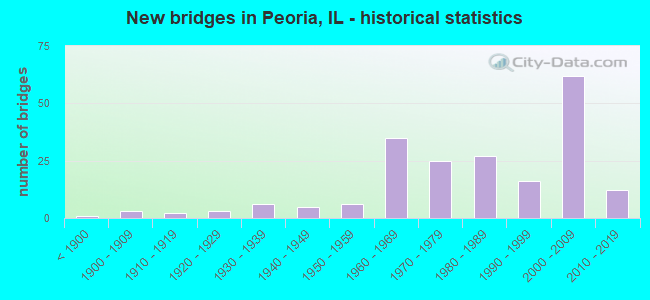
- New bridges - historical statistics
- 1Before 1900
- 31900-1909
- 21910-1919
- 31920-1929
- 61930-1939
- 51940-1949
- 61950-1959
- 351960-1969
- 251970-1979
- 271980-1989
- 161990-1999
- 622000-2009
- 122010-2019

- Reconstructed bridges - Historical Statistics
- 41970-1979
- 51980-1989
- 31990-1999
- 42000-2009
- 12010-2019


- Bridge Condition - Deck
- 5.8%Excellent
- 1.9%Very good
- 40.4%Good
- 36.5%Satisfactory
- 9.6%Fair
- 3.8%Poor
- 1.9%Serious
- 1.0%Critical

- Bridge Condition - Superstructure
- 11.1%Excellent
- 13.9%Very good
- 22.2%Good
- 22.2%Satisfactory
- 19.4%Fair
- 9.3%Poor
- 1.9%Serious
- 0.9%Critical

- Bridge Condition - Substructure
- 0.9%Excellent
- 13.9%Very good
- 30.6%Good
- 21.3%Satisfactory
- 23.1%Fair
- 8.3%Poor
- 1.9%Serious

- Bridge Condition - Channel
- 17.6%Very good
- 19.8%Good
- 28.6%Satisfactory
- 16.5%Fair
- 11.0%Poor
- 6.6%Serious

- Bridge Condition - Culverts
- 2.7%Very good
- 32.4%Good
- 29.7%Satisfactory
- 21.6%Fair
- 8.1%Poor
- 5.4%Serious
Find on map >> Show street view
Structure Number: 72501, Location: N LINESW1/4 19T9NR7E (Lat: 40.747111, Lng: -89.753922), Route carried "on" structure: County highway , Year Built: 2009, Status: Open, Structure Length: 1.09m (3.58ft), Average Daily Traffic: 175 (year 2017), Truck Traffic: 11%, Average Future Daily Traffic: 133 (year 2032), Design Load: HS 20, Features Intersected: BR KICKAPOO CK, Facility Carried by Structure: POWDER MILL RD
Minimum Vertical Clearance: 30+ m (98+ ft), Kilometerpoint: 0.370, Lanes on structure: 2, Owner: Town or Township Highway Agency, Approaching Roadway Width: 6.7m (22.0ft), Skew: 3 degrees, Material/Design: Concrete, Design/Construction: Frame, Number Of Spans In Main Unit: 1, Length of Maximum Span: 10.9m (35.8ft)
Condition: Superstructure: Very good, Substructure: Very good, Channel: Poor, Operating Rating: 44.1 metric tons, Method Used To Determine Operating Rating: Assigned rating based on Load Factor Design (LFD) reported by rating factor (RF) using MS18 loading, Inventory Rating: 32.4 metric tons, Method Used To Determine Inventory Rating: Assigned rating based on Load Factor Design (LFD) reported by rating factor (RF) using MS18 loading, Structural Evaluation: Equal to present desirable criteria, Waterway Adequacy: Equal to present minimum criteria, Approach Roadway Alignment: Equal to present desirable criteria, Designated Inspection Frequency: Every 48 months, Inspection Date: October 2018
Find on map >> Show street view
Structure Number: 725012, Location: W1/2-25-KICKAPOO (Lat: 40.735553, Lng: -89.658631), Route carried "on" structure: County highway , Year Built: 2019, Status: Open, Structure Length: 2.54m (8.33ft), Average Daily Traffic: 150 (year 2017), Truck Traffic: 13%, Average Future Daily Traffic: 174 (year 2038), Design Load: HS 25 or greater, Features Intersected: BIG HOLLOW CREEK, Facility Carried by Structure: RICHWOODS BLVD
Minimum Vertical Clearance: 30+ m (98+ ft), Kilometerpoint: 0.901, Lanes on structure: 2, Owner: Town or Township Highway Agency, Approaching Roadway Width: 7.3m (24.0ft), Material/Design: Prestressed concrete, Design/Construction: Box Beam or Girders - Multiple, Number Of Spans In Main Unit: 1, Length of Maximum Span: 24.4m (80.1ft), Curb-To-Curb Width: 7.3m (24.0ft), Out-to-Out Width: 7.3m (24.0ft)
Condition: Deck: Excellent, Superstructure: Excellent, Substructure: Excellent, Channel: Good, Operating Rating: 60.3 metric tons, Method Used To Determine Operating Rating: Load and Resistance Factor Rating (LRFR) rating reported by rating factor(RF) method using HL-93 loadings, Inventory Rating: 46.3 metric tons, Method Used To Determine Inventory Rating: Load and Resistance Factor Rating (LRFR) rating reported by rating factor(RF) method using HL-93 loadings, Structural Evaluation: Superior to present desirable criteria, Deck Geometry: Somewhat better than minimum adequacy, Waterway Adequacy: Better than present minimum criteria, Approach Roadway Alignment: High priority of corrective action, Designated Inspection Frequency: Every 24 months, Inspection Date: July 2019, Deck Structure Type: Concrete Precast Panels, Wearing Surface/Protective System: Wearing Surface: Bituminous, Membrane: Built-up, Deck Protection: Epoxy Coated Reinforcing
Find on map >> Show street view
Structure Number: 726001, Location: NW 5 T8NR8E (Lat: 40.710189, Lng: -89.621881), Route carried "on" structure: Other road , Year Built: 1966, Status: Open, Structure Length: 1.46m (4.79ft), Average Daily Traffic: 7,400 (year 2017), Truck Traffic: 4%, Average Future Daily Traffic: 8,071 (year 2032), Design Load: HS 20, Features Intersected: DRY RUN CREEK, Facility Carried by Structure: NEBRASKA AVE
Minimum Vertical Clearance: 30+ m (98+ ft), Kilometerpoint: 1.577, Lanes on structure: 4, Owner: City or Municipal Highway Agency, Approaching Roadway Width: 14.6m (47.9ft), Skew: 2 degrees, Material/Design: Concrete continuous, Design/Construction: Culvert, Number Of Spans In Main Unit: 3, Length of Maximum Span: 4.8m (15.7ft)
Condition: Channel: Good, Culverts: Satisfactory, Operating Rating: 53.8 metric tons, Method Used To Determine Operating Rating: Field evaluation and documented engineering judgment, Inventory Rating: 32.4 metric tons, Method Used To Determine Inventory Rating: Field evaluation and documented engineering judgment, Structural Evaluation: Equal to present minimum criteria, Waterway Adequacy: Superior to present desirable criteria, Approach Roadway Alignment: Equal to present desirable criteria, Designated Inspection Frequency: Every 24 months, Inspection Date: September 2021
Find on map >> Show street view
Structure Number: 726004, Location: SEC-13-T9NR7E (Lat: 40.756947, Lng: -89.644567), Route carried "on" structure: Other road , Year Built: 2005, Status: Open, Structure Length: 0.84m (2.76ft), Average Daily Traffic: 9,250 (year 2017), Truck Traffic: 2%, Average Future Daily Traffic: 9,877 (year 2032), Design Load: HS 20, Features Intersected: BIG HOLLOW CRK TRIB, Facility Carried by Structure: CHARTER OAK ROAD
Minimum Vertical Clearance: 30+ m (98+ ft), Kilometerpoint: 3.927, Lanes on structure: 4, Base Highway Network: Yes, Owner: City or Municipal Highway Agency, Approaching Roadway Width: 17.0m (55.8ft), Material/Design: Concrete continuous, Design/Construction: Culvert, Number Of Spans In Main Unit: 2, Length of Maximum Span: 4.1m (13.5ft)
Condition: Channel: Satisfactory, Culverts: Good, Operating Rating: 97.2 metric tons, Method Used To Determine Operating Rating: Load Factor (LF) rating reported by rating factor (RF) method using MS18 loading, Inventory Rating: 59.3 metric tons, Method Used To Determine Inventory Rating: Load Factor (LF) rating reported by rating factor (RF) method using MS18 loading, Structural Evaluation: Better than present minimum criteria, Waterway Adequacy: Equal to present minimum criteria, Approach Roadway Alignment: Equal to present desirable criteria, Designated Inspection Frequency: Every 48 months, Inspection Date: September 2021
Find on map >> Show street view
Structure Number: 726007, Location: FRNT RD SW OF US 150 (Lat: 40.756339, Lng: -89.648731), Route carried "on" structure: City street , Year Built: 1990, Status: Open, Structure Length: 2.91m (9.55ft), Average Daily Traffic: 25 (year 2017), Average Future Daily Traffic: 133 (year 2032), Design Load: HS 20, Features Intersected: BIG HOLLOW CR, Facility Carried by Structure: OLD BIG HOLLOW ROA
Minimum Vertical Clearance: 30+ m (98+ ft), Kilometerpoint: 0.177, Lanes on structure: 2, Owner: City or Municipal Highway Agency, Approaching Roadway Width: 6.7m (22.0ft), Skew: 1 degrees, Material/Design: Steel, Design/Construction: Stringer/Multi-beam, Number Of Spans In Main Unit: 1, Length of Maximum Span: 27.4m (89.9ft), Curb-To-Curb Width: 9.8m (32.2ft), Out-to-Out Width: 10.7m (35.1ft)
Condition: Deck: Satisfactory, Superstructure: Satisfactory, Substructure: Fair, Channel: Serious, Operating Rating: 53.8 metric tons, Method Used To Determine Operating Rating: Assigned rating based on Load Factor Design (LFD) reported by rating factor (RF) using MS18 loading, Inventory Rating: 32.4 metric tons, Method Used To Determine Inventory Rating: Assigned rating based on Load Factor Design (LFD) reported by rating factor (RF) using MS18 loading, Structural Evaluation: Somewhat better than minimum adequacy, Deck Geometry: Equal to present desirable criteria, Waterway Adequacy: Equal to present desirable criteria, Approach Roadway Alignment: Somewhat better than minimum adequacy, Designated Inspection Frequency: Every 24 months, Inspection Date: September 2021, Deck Structure Type: Concrete Cast-file-Place, Wearing Surface/Protective System: Deck Protection: Epoxy Coated Reinforcing
Find on map >> Show street view
Structure Number: 72601, Location: SWCOR-SW-30-Medina (Lat: 40.813078, Lng: -89.630658), Route carried "on" structure: Other road , Year Built: 2013, Status: Open, Structure Length: 0.72m (2.36ft), Average Daily Traffic: 5,650 (year 2020), Truck Traffic: 2%, Average Future Daily Traffic: 5,416 (year 2032), Design Load: HS 25 or greater, Features Intersected: Trib to Kickapoo Crk, Facility Carried by Structure: Alta Rd/FAU 6641
Minimum Vertical Clearance: 30+ m (98+ ft), Kilometerpoint: 0.016, Lanes on structure: 2, Base Highway Network: Yes, Owner: City or Municipal Highway Agency, Approaching Roadway Width: 9.9m (32.5ft), Skew: 5 degrees, Material/Design: Concrete, Design/Construction: Culvert, Number Of Spans In Main Unit: 2, Length of Maximum Span: 3.0m (9.8ft), Curb-To-Curb Width: 18.0m (59.1ft), Out-to-Out Width: 18.0m (59.1ft)
Condition: Channel: Very good, Culverts: Very good, Operating Rating: 42.1 metric tons, Method Used To Determine Operating Rating: Assigned ratings based on Load and Resistance Factor Design (LRFD) reported by rating factor (RF) using HL93 loadings, Inventory Rating: 32.4 metric tons, Method Used To Determine Inventory Rating: Assigned ratings based on Load and Resistance Factor Design (LRFD) reported by rating factor (RF) using HL93 loadings, Structural Evaluation: Equal to present desirable criteria, Deck Geometry: Superior to present desirable criteria, Waterway Adequacy: Equal to present minimum criteria, Approach Roadway Alignment: Equal to present minimum criteria, Designated Inspection Frequency: Every 48 months, Inspection Date: January 2020, Deck Structure Type: Other
Find on map >> Show street view
Structure Number: 726012, Location: 1/4 Mi. N. of I-74 (Lat: 40.710453, Lng: -89.600836), Route carried "on" structure: Other road , Year Built: 2015, Status: Open, Structure Length: 1.71m (5.61ft), Average Daily Traffic: 4,800 (year 2017), Truck Traffic: 5%, Average Future Daily Traffic: 5,012 (year 2035), Design Load: HS 25 or greater, Features Intersected: DRY RUN CREEK, Facility Carried by Structure: NEBRASKA AVE.
Minimum Vertical Clearance: 30+ m (98+ ft), Kilometerpoint: 3.396, Lanes on structure: 4, Owner: City or Municipal Highway Agency, Approaching Roadway Width: 11.9m (39.0ft), Material/Design: Prestressed concrete, Design/Construction: Stringer/Multi-beam, Number Of Spans In Main Unit: 1, Length of Maximum Span: 16.5m (54.1ft), Curb or Sidewalk Widths: Left: 2.0m (6.6ft), Right: 2.0m (6.6ft), Curb-To-Curb Width: 11.9m (39.0ft), Out-to-Out Width: 16.5m (54.1ft)
Condition: Deck: Very good, Superstructure: Very good, Substructure: Very good, Channel: Very good, Operating Rating: 42.1 metric tons, Method Used To Determine Operating Rating: Assigned ratings based on Load and Resistance Factor Design (LRFD) reported by rating factor (RF) using HL93 loadings, Inventory Rating: 32.4 metric tons, Method Used To Determine Inventory Rating: Assigned ratings based on Load and Resistance Factor Design (LRFD) reported by rating factor (RF) using HL93 loadings, Structural Evaluation: Equal to present desirable criteria, Deck Geometry: High priority of replacement, Waterway Adequacy: Equal to present desirable criteria, Approach Roadway Alignment: Equal to present desirable criteria, Designated Inspection Frequency: Every 48 months, Inspection Date: September 2021, Deck Structure Type: Concrete Cast-file-Place, Wearing Surface/Protective System: Deck Protection: Epoxy Coated Reinforcing
Find on map >> Show street view
Structure Number: 726013, Location: 0.10 Mi. N. of I-74 (Lat: 40.707906, Lng: -89.603583), Route carried "on" structure: Other road , Year Built: 2016, Status: Open, Structure Length: 1.11m (3.64ft), Average Daily Traffic: 2,525 (year 2017), Truck Traffic: 7%, Average Future Daily Traffic: 2,929 (year 2038), Design Load: HS 25 or greater, Features Intersected: Dry Run Creek, Facility Carried by Structure: FAU-6595
Minimum Vertical Clearance: 30+ m (98+ ft), Kilometerpoint: 6.775, Lanes on structure: 3, Base Highway Network: Yes, Owner: City or Municipal Highway Agency, Approaching Roadway Width: 12.8m (42.0ft), Skew: 2 degrees, Material/Design: Concrete, Design/Construction: Frame, Number Of Spans In Main Unit: 1, Length of Maximum Span: 11.1m (36.4ft), Curb or Sidewalk Widths: Left: 1.5m (4.9ft), Right: 1.5m (4.9ft), Curb-To-Curb Width: 1.5m (4.9ft), Out-to-Out Width: 1.5m (4.9ft)
Condition: Superstructure: Very good, Substructure: Very good, Channel: Good, Operating Rating: 42.1 metric tons, Method Used To Determine Operating Rating: Assigned ratings based on Load and Resistance Factor Design (LRFD) reported by rating factor (RF) using HL93 loadings, Inventory Rating: 32.4 metric tons, Method Used To Determine Inventory Rating: Assigned ratings based on Load and Resistance Factor Design (LRFD) reported by rating factor (RF) using HL93 loadings, Structural Evaluation: Equal to present desirable criteria, Deck Geometry: High priority of replacement, Waterway Adequacy: Superior to present desirable criteria, Approach Roadway Alignment: Equal to present desirable criteria, Designated Inspection Frequency: Every 48 months, Inspection Date: September 2019
Find on map >> Show street view
Structure Number: 726015, Location: NE1/4Sec8 T18N R8E (Lat: 40.693439, Lng: -89.608669), Route carried "on" structure: Other road , Year Built: 2018, Status: Open, Structure Length: 1.99m (6.53ft), Average Daily Traffic: 4,575 (year 2020), Truck Traffic: 3%, Average Future Daily Traffic: 4,524 (year 2038), Design Load: HS 25 or greater, Features Intersected: R B GARRETT AVE, Facility Carried by Structure: MACARTHUR HWY
Minimum Vertical Clearance: 30+ m (98+ ft), Kilometerpoint: 12.021, Lanes on structure: 2, Lanes under structure: 3, Base Highway Network: Yes, Owner: City or Municipal Highway Agency, Approaching Roadway Width: 9.4m (30.8ft), Skew: 32 degrees, Material/Design: Concrete, Design/Construction: Stringer/Multi-beam, Number Of Spans In Main Unit: 1, Length of Maximum Span: 19.2m (63.0ft), Curb or Sidewalk Widths: Left: 3.0m (9.8ft), Right: 1.8m (5.9ft), Curb-To-Curb Width: 9.4m (30.8ft), Out-to-Out Width: 15.8m (51.8ft)
Condition: Deck: Very good, Superstructure: Very good, Substructure: Very good, Operating Rating: 55.7 metric tons, Method Used To Determine Operating Rating: Load and Resistance Factor Rating (LRFR) rating reported by rating factor(RF) method using HL-93 loadings, Inventory Rating: 42.8 metric tons, Method Used To Determine Inventory Rating: Load and Resistance Factor Rating (LRFR) rating reported by rating factor(RF) method using HL-93 loadings, Structural Evaluation: Equal to present desirable criteria, Deck Geometry: Meets minimum limits, Underclear: Meets minimum limits, Approach Roadway Alignment: Equal to present minimum criteria, Designated Inspection Frequency: Every 48 months, Inspection Date: September 2020, Deck Structure Type: Concrete Cast-file-Place, Wearing Surface/Protective System: Deck Protection: Epoxy Coated Reinforcing
Find on map >> Show street view
Structure Number: 726056, Location: E CTR-25-T10NR7E (Lat: 40.820267, Lng: -89.645006), Route carried "on" structure: City street , Year Built: 2012, Status: Open, Structure Length: 4.54m (14.90ft), Average Daily Traffic: 2,400 (year 2017), Truck Traffic: 3%, Average Future Daily Traffic: 1,250 (year 2034), Design Load: HS 25 or greater, Features Intersected: Trib to Kickapoo Crk, Facility Carried by Structure: Wilhelm Rd (CH 31D
Minimum Vertical Clearance: 30+ m (98+ ft), Kilometerpoint: 0.402, Lanes on structure: 2, Owner: City or Municipal Highway Agency, Approaching Roadway Width: 11.0m (36.1ft), Material/Design: Prestressed concrete, Design/Construction: Box Beam or Girders - Multiple, Number Of Spans In Main Unit: 3, Number Of Approach Spans: 2, Length of Maximum Span: 21.3m (69.9ft), Curb or Sidewalk Widths: Left: 0.0m, Right: 3.4m (11.2ft), Curb-To-Curb Width: 12.2m (40.0ft), Out-to-Out Width: 16.5m (54.1ft)
Condition: Deck: Fair, Superstructure: Satisfactory, Substructure: Fair, Channel: Fair, Operating Rating: 42.1 metric tons, Method Used To Determine Operating Rating: Assigned ratings based on Load and Resistance Factor Design (LRFD) reported by rating factor (RF) using HL93 loadings, Inventory Rating: 32.4 metric tons, Method Used To Determine Inventory Rating: Assigned ratings based on Load and Resistance Factor Design (LRFD) reported by rating factor (RF) using HL93 loadings, Structural Evaluation: Somewhat better than minimum adequacy, Deck Geometry: Equal to present minimum criteria, Waterway Adequacy: Superior to present desirable criteria, Approach Roadway Alignment: Equal to present desirable criteria, Designated Inspection Frequency: Every 24 months, Inspection Date: September 2021, Deck Structure Type: Concrete Precast Panels, Wearing Surface/Protective System: Wearing Surface: Integral Concrete, Deck Protection: Epoxy Coated Reinforcing
Find on map >> Show street view
Structure Number: 727002, Location: NW-5-T8NR8E (Lat: 40.705281, Lng: -89.620717), Route carried "on" structure: County highway , Year Built: 1930, Status: Temporarily open, Structure Length: 1.28m (4.20ft), Average Daily Traffic: 550 (year 2017), Truck Traffic: 4%, Average Future Daily Traffic: 584 (year 2032), Features Intersected: DRY RUN CR, Facility Carried by Structure: PARK ROAD
Minimum Vertical Clearance: 30+ m (98+ ft), Kilometerpoint: 0.048, Lanes on structure: 2, Owner: Local Park, Forest, or Reservation Agency, Approaching Roadway Width: 6.1m (20.0ft), Material/Design: Concrete, Design/Construction: Channel Beam, Number Of Spans In Main Unit: 1, Length of Maximum Span: 12.2m (40.0ft), Curb or Sidewalk Widths: Left: 0.0m, Right: 1.5m (4.9ft), Curb-To-Curb Width: 7.3m (24.0ft), Out-to-Out Width: 9.2m (30.2ft)
Condition: Deck: Satisfactory, Superstructure: Fair, Substructure: Satisfactory, Channel: Fair, Operating Rating: 5.2 metric tons, Method Used To Determine Operating Rating: Allowable Stress (AS) rating reported by rating factor (RF) method using MS18 loading, Structural Evaluation: High priority of corrective action, Deck Geometry: Meets minimum limits, Waterway Adequacy: Better than present minimum criteria, Approach Roadway Alignment: Meets minimum limits, Length Of Structure Improvement: 1.28m (4.20ft), Designated Inspection Frequency: Every 24 months, Inspection Date: October 2020, Bridge Improvement Cost: $80,000, Roadway Improvement Cost: $8,000, Total Project Cost: $120,000, Deck Structure Type: Concrete Precast Panels, Wearing Surface/Protective System: Wearing Surface: Bituminous
Find on map >> Show street view
Structure Number: 727005, Location: BRADLEY PARK (Lat: 40.708764, Lng: -89.622761), Route carried "on" structure: County highway , Year Built: 2009, Status: Open, Structure Length: 2.06m (6.76ft), Average Daily Traffic: 75 (year 2017), Average Future Daily Traffic: 80 (year 2032), Design Load: HS 25 or greater, Features Intersected: DRY RUN CR, Facility Carried by Structure: PARK ROAD
Minimum Vertical Clearance: 30+ m (98+ ft), Kilometerpoint: 0.483, Lanes on structure: 2, Owner: Local Park, Forest, or Reservation Agency, Approaching Roadway Width: 6.1m (20.0ft), Material/Design: Prestressed concrete, Design/Construction: Box Beam or Girders - Multiple, Number Of Spans In Main Unit: 1, Length of Maximum Span: 19.8m (65.0ft), Curb-To-Curb Width: 7.3m (24.0ft), Out-to-Out Width: 7.3m (24.0ft)
Condition: Deck: Very good, Superstructure: Very good, Substructure: Very good, Channel: Satisfactory, Operating Rating: 44.1 metric tons, Method Used To Determine Operating Rating: Assigned rating based on Load Factor Design (LFD) reported by rating factor (RF) using MS18 loading, Inventory Rating: 32.4 metric tons, Method Used To Determine Inventory Rating: Assigned rating based on Load Factor Design (LFD) reported by rating factor (RF) using MS18 loading, Structural Evaluation: Equal to present desirable criteria, Deck Geometry: Equal to present minimum criteria, Waterway Adequacy: Equal to present desirable criteria, Approach Roadway Alignment: Equal to present desirable criteria, Designated Inspection Frequency: Every 48 months, Inspection Date: March 2021, Deck Structure Type: Concrete Precast Panels, Wearing Surface/Protective System: Wearing Surface: Bituminous, Deck Protection: Epoxy Coated Reinforcing
Find on map >> Show street view
Structure Number: 728, Location: NW-32-T9NR8E (Lat: 40.720150, Lng: -89.620936), Route carried "on" structure: Other road , Year Built: 1965, Status: Open, Structure Length: 1.04m (3.41ft), Average Daily Traffic: 2,500 (year 2020), Truck Traffic: 3%, Average Future Daily Traffic: 3,239 (year 2032), Design Load: HS 20, Features Intersected: DRY RUN CREEK, Facility Carried by Structure: GALE AVE - FAU 659
Minimum Vertical Clearance: 30+ m (98+ ft), Kilometerpoint: 4.683, Lanes on structure: 2, Base Highway Network: Yes, Owner: State Highway Agency, Approaching Roadway Width: 5.2m (17.1ft), Skew: 34 degrees, Material/Design: Concrete continuous, Design/Construction: Culvert, Number Of Spans In Main Unit: 2, Length of Maximum Span: 4.7m (15.4ft)
Condition: Channel: Fair, Culverts: Fair, Operating Rating: 54.1 metric tons, Method Used To Determine Operating Rating: Field evaluation and documented engineering judgment, Inventory Rating: 32.4 metric tons, Method Used To Determine Inventory Rating: Field evaluation and documented engineering judgment, Structural Evaluation: Somewhat better than minimum adequacy, Waterway Adequacy: Equal to present desirable criteria, Approach Roadway Alignment: Equal to present desirable criteria, Designated Inspection Frequency: Every 24 months, Inspection Date: January 2021
Find on map >> Show street view
Structure Number: 728001, Location: CTR-18-T9NR8E (Lat: 40.761808, Lng: -89.631633), Route carried "on" structure: Other road , Year Built: 1964, Status: Open, Structure Length: 0.86m (2.82ft), Average Daily Traffic: 6,100 (year 2020), Truck Traffic: 1%, Average Future Daily Traffic: 9,133 (year 2032), Design Load: HS 15, Features Intersected: BIG HOLLOW CR., Facility Carried by Structure: FAU-6647 (NMOOR RD
Minimum Vertical Clearance: 30+ m (98+ ft), Kilometerpoint: 0.032, Lanes on structure: 2, Base Highway Network: Yes, Owner: City or Municipal Highway Agency, Approaching Roadway Width: 9.8m (32.2ft), Skew: 2 degrees, Material/Design: Concrete continuous, Design/Construction: Culvert, Number Of Spans In Main Unit: 2, Length of Maximum Span: 4.2m (13.8ft)
Condition: Channel: Serious, Culverts: Good, Operating Rating: 59.0 metric tons, Method Used To Determine Operating Rating: Load Factor (LF) rating reported by rating factor (RF) method using MS18 loading, Inventory Rating: 35.3 metric tons, Method Used To Determine Inventory Rating: Load Factor (LF) rating reported by rating factor (RF) method using MS18 loading, Structural Evaluation: Better than present minimum criteria, Waterway Adequacy: Equal to present minimum criteria, Approach Roadway Alignment: Equal to present desirable criteria, Designated Inspection Frequency: Every 24 months, Inspection Date: November 2020
Find on map >> Show street view
Structure Number: 775, Location: 2 MI SE ULLIN (Lat: 37.271361, Lng: -89.155311), Route carried "on" structure: County highway , Year Built: 1965, Status: Open, Structure Length: 0.79m (2.59ft), Average Daily Traffic: 1,500 (year 2018), Truck Traffic: 14%, Average Future Daily Traffic: 2,251 (year 2032), Design Load: HS 15, Features Intersected: CREEK, Facility Carried by Structure: FAS 938
Minimum Vertical Clearance: 30+ m (98+ ft), Kilometerpoint: 2.511, Lanes on structure: 2, Owner: County Highway Agency, Approaching Roadway Width: 10.4m (34.1ft), Material/Design: Concrete, Design/Construction: Culvert, Number Of Spans In Main Unit: 3, Length of Maximum Span: 2.3m (7.5ft)
Condition: Channel: Satisfactory, Culverts: Poor, Operating Rating: 32.4 metric tons, Method Used To Determine Operating Rating: Field evaluation and documented engineering judgment, Structural Evaluation: High priority of corrective action, Waterway Adequacy: Superior to present desirable criteria, Approach Roadway Alignment: Equal to present desirable criteria, Designated Inspection Frequency: Every 24 months, Inspection Date: November 2020
Find on map >> Show street view
Structure Number: 872, Location: .4 MI W ROBINSON CR (Lat: 39.405847, Lng: -88.902458), Route carried "on" structure: State highway 16, Year Built: 1966, Status: Open, Structure Length: 1.39m (4.56ft), Average Daily Traffic: 4,800 (year 2021), Truck Traffic: 16%, Average Future Daily Traffic: 5,399 (year 2032), Design Load: HS 20, Features Intersected: STREAM
Minimum Vertical Clearance: 30+ m (98+ ft), Kilometerpoint: 170.360, Lanes on structure: 2, Base Highway Network: Yes, Owner: State Highway Agency, Approaching Roadway Width: 9.1m (29.9ft), Skew: 4 degrees, Material/Design: Concrete, Design/Construction: Culvert, Number Of Spans In Main Unit: 3, Length of Maximum Span: 4.8m (15.7ft)
Condition: Channel: Satisfactory, Culverts: Good, Operating Rating: 97.2 metric tons, Method Used To Determine Operating Rating: Load Factor (LF) rating reported by rating factor (RF) method using MS18 loading, Inventory Rating: 97.2 metric tons, Method Used To Determine Inventory Rating: Load Factor (LF) rating reported by rating factor (RF) method using MS18 loading, Structural Evaluation: Better than present minimum criteria, Waterway Adequacy: Equal to present desirable criteria, Approach Roadway Alignment: Equal to present desirable criteria, Designated Inspection Frequency: Every 24 months, Inspection Date: July 2020
Find on map >> Show street view
Structure Number: 882, Location: S CL OF BRADFORD (Lat: 41.172689, Lng: -89.657761), Route carried "on" structure: State highway 40, Year Built: 1996, Status: Open, Structure Length: 0.73m (2.40ft), Average Daily Traffic: 1,650 (year 2021), Truck Traffic: 16%, Average Future Daily Traffic: 1,874 (year 2032), Design Load: HS 20, Features Intersected: DEFEAT CREEK
Minimum Vertical Clearance: 30+ m (98+ ft), Kilometerpoint: 59.415, Lanes on structure: 2, Base Highway Network: Yes, Owner: State Highway Agency, Approaching Roadway Width: 10.4m (34.1ft), Skew: 1 degrees, Material/Design: Concrete continuous, Design/Construction: Culvert, Number Of Spans In Main Unit: 2, Length of Maximum Span: 3.4m (11.2ft)
Condition: Channel: Good, Culverts: Good, Operating Rating: 62.9 metric tons, Method Used To Determine Operating Rating: Load Factor (LF) rating reported by rating factor (RF) method using MS18 loading, Inventory Rating: 37.9 metric tons, Method Used To Determine Inventory Rating: Load Factor (LF) rating reported by rating factor (RF) method using MS18 loading, Structural Evaluation: Better than present minimum criteria, Waterway Adequacy: Equal to present desirable criteria, Approach Roadway Alignment: Equal to present desirable criteria, Designated Inspection Frequency: Every 48 months, Inspection Date: May 2018
Find on map >> Show street view
Structure Number: 900001, Location: I-74 OVR ILLINOIS R (Lat: 40.692597, Lng: -89.585481), Route carried "on" structure: Interstate 74, Year Built: 1958, Year Reconstructed: 2005, Status: Open, Structure Length: 98.05m (321.69ft), Average Daily Traffic: 50,000 (year 2021), Truck Traffic: 6%, Average Future Daily Traffic: 63,720 (year 2032), Design Load: HS 20, Features Intersected: ILL RIV (604034P)
Minimum Vertical Clearance: 5.46m (17.91ft), Kilometerpoint: 153.270, Lanes on structure: 4, Lanes under structure: 4, Base Highway Network: Yes, Owner: State Highway Agency, Approaching Roadway Width: 11.0m (36.1ft), Skew: 30 degrees, Navigation Control: Yes ( Vertical Clearance: 14.9m (48.9ft), Horizontal Clearance: 152.4m (500.0ft)), Material/Design: Steel continuous, Design/Construction: Truss - Thru, Number Of Spans In Main Unit: 13, Length of Maximum Span: 182.9m (600.1ft), Curb-To-Curb Width: 16.8m (55.1ft), Out-to-Out Width: 18.5m (60.7ft)
Condition: Deck: Good, Superstructure: Fair, Substructure: Satisfactory, Channel: Very good, Operating Rating: 41.5 metric tons, Method Used To Determine Operating Rating: Load Factor (LF) rating reported by rating factor (RF) method using MS18 loading, Inventory Rating: 24.6 metric tons, Method Used To Determine Inventory Rating: Load Factor (LF) rating reported by rating factor (RF) method using MS18 loading, Structural Evaluation: Somewhat better than minimum adequacy, Deck Geometry: Meets minimum limits, Underclear: High priority of corrective action, Waterway Adequacy: Equal to present desirable criteria, Approach Roadway Alignment: Equal to present minimum criteria, Length Of Structure Improvement: 98.05m (321.69ft), Designated Inspection Frequency: Every 24 months, Critical Feature Inspection Frequency: Every 24 months, Underwater Inspection Frequency: Every 60 months, Inspection Date: October 2020, Critical Feature Inspection Date: October 2020, Underwater Inspection Date: October 2020, Bridge Improvement Cost: $3,899,000, Roadway Improvement Cost: $195,000, Total Project Cost: $4,679,000, Deck Structure Type: Concrete Cast-file-Place, Wearing Surface/Protective System: Deck Protection: Epoxy Coated Reinforcing
Find on map >> Show street view
Structure Number: 90003, Location: CEDAR ST AT PEORIA (Lat: 40.680686, Lng: -89.604117), Route carried "on" structure: State highway 8, Year Built: 1932, Year Reconstructed: 1988, Status: Posted for load, Structure Length: 114.30m (375.00ft), Average Daily Traffic: 12,400 (year 2021), Truck Traffic: 5%, Average Future Daily Traffic: 11,682 (year 2032), Design Load: H 20, Features Intersected: ILLINOIS RIVER
Minimum Vertical Clearance: 30+ m (98+ ft), Kilometerpoint: 54.282, Lanes on structure: 4, Base Highway Network: Yes, Owner: State Highway Agency, Approaching Roadway Width: 15.8m (51.8ft), Navigation Control: Yes ( Vertical Clearance: 18.9m (62.0ft), Horizontal Clearance: 85.3m (279.9ft)), Material/Design: Steel continuous, Design/Construction: Truss - Deck, Number Of Spans In Main Unit: 34, Number Of Approach Spans: 4, Length of Maximum Span: 90.2m (295.9ft), Curb-To-Curb Width: 15.0m (49.2ft), Out-to-Out Width: 15.9m (52.2ft)
Condition: Deck: Satisfactory, Superstructure: Serious, Substructure: Fair, Channel: Very good, Operating Rating: 40.5 metric tons, Method Used To Determine Operating Rating: Load Factor (LF) rating reported by rating factor (RF) method using MS18 loading, Inventory Rating: 24.3 metric tons, Method Used To Determine Inventory Rating: Load Factor (LF) rating reported by rating factor (RF) method using MS18 loading, Structural Evaluation: High priority of corrective action, Deck Geometry: High priority of replacement, Underclear: Somewhat better than minimum adequacy, Waterway Adequacy: Superior to present desirable criteria, Approach Roadway Alignment: Equal to present desirable criteria, Bridge Posting: Required (Relationship of Operating Rating to Maximum Legal Load: 20.0 - 29.9% below), Length Of Structure Improvement: 114.30m (375.00ft), Designated Inspection Frequency: Every 12 months, Critical Feature Inspection Frequency: Every 12 months, Underwater Inspection Frequency: Every 60 months, Inspection Date: June 2021, Critical Feature Inspection Date: June 2021, Underwater Inspection Date: June 2021, Bridge Improvement Cost: $25,889,000, Roadway Improvement Cost: $2,589,000, Total Project Cost: $38,834,000, Deck Structure Type: Concrete Cast-file-Place, Wearing Surface/Protective System: Deck Protection: Epoxy Coated Reinforcing
Find on map >> Show street view
Structure Number: 90007, Location: NE END OF PEORIA (Lat: 40.722581, Lng: -89.554019), Route carried "on" structure: US 150, Year Built: 1948, Year Reconstructed: 2000, Status: Open, Structure Length: 144.63m (474.51ft), Average Daily Traffic: 30,000 (year 2021), Truck Traffic: 3%, Average Future Daily Traffic: 22,355 (year 2032), Design Load: H 20, Features Intersected: ILLINOIS RIVER
Minimum Vertical Clearance: 5.21m (17.09ft), Kilometerpoint: 143.260, Lanes on structure: 2, Base Highway Network: Yes, Owner: State Highway Agency, Approaching Roadway Width: 12.8m (42.0ft), Navigation Control: Yes ( Vertical Clearance: 14.9m (48.9ft), Horizontal Clearance: 125.3m (411.1ft)), Material/Design: Steel continuous, Design/Construction: Truss - Thru, Number Of Spans In Main Unit: 3, Number Of Approach Spans: 25, Length of Maximum Span: 163.4m (536.1ft), Curb-To-Curb Width: 8.8m (28.9ft), Out-to-Out Width: 9.1m (29.9ft)
Condition: Deck: Satisfactory, Superstructure: Serious, Substructure: Fair, Channel: Very good, Operating Rating: 35.0 metric tons, Method Used To Determine Operating Rating: Load Factor (LF) rating reported by rating factor (RF) method using MS18 loading, Inventory Rating: 21.1 metric tons, Method Used To Determine Inventory Rating: Load Factor (LF) rating reported by rating factor (RF) method using MS18 loading, Structural Evaluation: High priority of corrective action, Deck Geometry: High priority of corrective action, Underclear: Equal to present desirable criteria, Waterway Adequacy: Superior to present desirable criteria, Approach Roadway Alignment: Equal to present minimum criteria, Length Of Structure Improvement: 144.63m (474.51ft), Designated Inspection Frequency: Every 12 months, Critical Feature Inspection Frequency: Every 12 months, Underwater Inspection Frequency: Every 60 months, Inspection Date: July 2021, Critical Feature Inspection Date: July 2021, Underwater Inspection Date: July 2020, Bridge Improvement Cost: $8,541,000, Roadway Improvement Cost: $854,000, Total Project Cost: $12,812,000, Deck Structure Type: Closed Grating, Wearing Surface/Protective System: Deck Protection: Epoxy Coated Reinforcing
Find on map >> Show street view
Structure Number: 900115, Location: IN PEORIA (Lat: 40.722528, Lng: -89.553839), Route carried "on" structure: US 150, Year Built: 1982, Status: Open, Structure Length: 144.63m (474.51ft), Average Daily Traffic: 30,000 (year 2021), Truck Traffic: 3%, Average Future Daily Traffic: 22,355 (year 2032), Design Load: HS 20, Features Intersected: ILL RIVER & CRI&P RR
Minimum Vertical Clearance: 30+ m (98+ ft), Kilometerpoint: 143.276, Lanes on structure: 2, Base Highway Network: Yes, Owner: State Highway Agency, Approaching Roadway Width: 12.8m (42.0ft), Navigation Control: Yes ( Vertical Clearance: 14.9m (48.9ft), Horizontal Clearance: 125.3m (411.1ft)), Material/Design: Steel continuous, Design/Construction: Truss - Thru, Number Of Spans In Main Unit: 3, Number Of Approach Spans: 20, Length of Maximum Span: 190.8m (626.0ft), Curb-To-Curb Width: 11.9m (39.0ft), Out-to-Out Width: 12.8m (42.0ft)
Condition: Deck: Fair, Superstructure: Poor, Substructure: Satisfactory, Channel: Very good, Operating Rating: 49.2 metric tons, Method Used To Determine Operating Rating: Load Factor (LF) rating reported by rating factor (RF) method using MS18 loading, Inventory Rating: 27.2 metric tons, Method Used To Determine Inventory Rating: Load Factor (LF) rating reported by rating factor (RF) method using MS18 loading, Structural Evaluation: Meets minimum limits, Deck Geometry: Better than present minimum criteria, Underclear: Equal to present desirable criteria, Waterway Adequacy: Equal to present desirable criteria, Approach Roadway Alignment: Equal to present desirable criteria, Designated Inspection Frequency: Every 12 months, Critical Feature Inspection Frequency: Every 12 months, Underwater Inspection Frequency: Every 60 months, Inspection Date: April 2021, Critical Feature Inspection Date: April 2021, Underwater Inspection Date: April 2021, Deck Structure Type: Concrete Cast-file-Place, Wearing Surface/Protective System: Deck Protection: Epoxy Coated Reinforcing
Find on map >> Show street view
Structure Number: 900122, Location: Bob Michel Bridge (Lat: 40.687561, Lng: -89.593689), Route carried "on" structure: State highway 40, Year Built: 1993, Status: Open, Structure Length: 72.09m (236.52ft), Average Daily Traffic: 15,300 (year 2021), Truck Traffic: 3%, Average Future Daily Traffic: 20,284 (year 2032), Design Load: HS 20, Features Intersected: IL RIV,WASH.ST.&RR'S
Minimum Vertical Clearance: 30+ m (98+ ft), Kilometerpoint: 1.722, Lanes on structure: 4, Lanes under structure: 8, Base Highway Network: Yes, Owner: State Highway Agency, Approaching Roadway Width: 23.2m (76.1ft), Skew: 30 degrees, Navigation Control: Yes ( Vertical Clearance: 18.9m (62.0ft), Horizontal Clearance: 93.0m (305.1ft)), Material/Design: Steel continuous, Design/Construction: Stringer/Multi-beam, Number Of Spans In Main Unit: 3, Number Of Approach Spans: 17, Length of Maximum Span: 109.7m (359.9ft), Curb or Sidewalk Widths: Left: 1.5m (4.9ft), Right: 1.5m (4.9ft), Curb-To-Curb Width: 18.9m (62.0ft), Out-to-Out Width: 23.2m (76.1ft)
Condition: Deck: Satisfactory, Superstructure: Satisfactory, Substructure: Fair, Channel: Very good, Operating Rating: 68.0 metric tons, Method Used To Determine Operating Rating: Load Factor (LF) rating reported by rating factor (RF) method using MS18 loading, Inventory Rating: 40.5 metric tons, Method Used To Determine Inventory Rating: Load Factor (LF) rating reported by rating factor (RF) method using MS18 loading, Structural Evaluation: Somewhat better than minimum adequacy, Deck Geometry: Equal to present minimum criteria, Underclear: Meets minimum limits, Waterway Adequacy: Superior to present desirable criteria, Approach Roadway Alignment: Equal to present desirable criteria, Designated Inspection Frequency: Every 24 months, Underwater Inspection Frequency: Every 60 months, Inspection Date: October 2021, Underwater Inspection Date: October 2021, Deck Structure Type: Concrete Cast-file-Place, Wearing Surface/Protective System: Deck Protection: Epoxy Coated Reinforcing
Find on map >> Show street view
Structure Number: 925, Location: 1 MI NW ROSSVILLE (Lat: 40.397261, Lng: -87.685464), Route carried "on" structure: County highway , Year Built: 1900, Status: Open, Structure Length: 0.79m (2.59ft), Average Daily Traffic: 50 (year 2019), Truck Traffic: 2%, Average Future Daily Traffic: 565 (year 2032), Features Intersected: N FORK VERMILION RIV, Facility Carried by Structure: TR 39
Minimum Vertical Clearance: 30+ m (98+ ft), Kilometerpoint: 21.307, Lanes on structure: 2, Owner: Town or Township Highway Agency, Approaching Roadway Width: 8.5m (27.9ft), Material/Design: Concrete, Design/Construction: Culvert, Number Of Spans In Main Unit: 2, Length of Maximum Span: 3.7m (12.1ft), Curb-To-Curb Width: 9.1m (29.9ft), Out-to-Out Width: 9.8m (32.2ft)
Condition: Channel: Satisfactory, Culverts: Fair, Operating Rating: 40.5 metric tons, Method Used To Determine Operating Rating: Field evaluation and documented engineering judgment, Inventory Rating: 24.3 metric tons, Method Used To Determine Inventory Rating: Field evaluation and documented engineering judgment, Structural Evaluation: Somewhat better than minimum adequacy, Deck Geometry: Better than present minimum criteria, Waterway Adequacy: Equal to present minimum criteria, Approach Roadway Alignment: Better than present minimum criteria, Length Of Structure Improvement: 0.79m (2.59ft), Designated Inspection Frequency: Every 24 months, Inspection Date: Febuary 2021, Bridge Improvement Cost: $40,000, Roadway Improvement Cost: $4,000, Total Project Cost: $60,000
Find on map >> Show street view
Structure Number: 926, Location: 1 BLK N CLEVELAND ST (Lat: 40.124667, Lng: -87.617469), Route carried "on" structure: US 136, Year Built: 1896, Year Reconstructed: 1981, Status: Open, Structure Length: 1.87m (6.14ft), Average Daily Traffic: 9,700 (year 2021), Truck Traffic: 8%, Average Future Daily Traffic: 10,886 (year 2032), Design Load: HS 20, Features Intersected: STONY CREEK
Minimum Vertical Clearance: 30+ m (98+ ft), Kilometerpoint: 356.363, Lanes on structure: 4, Base Highway Network: Yes, Owner: State Highway Agency, Approaching Roadway Width: 15.2m (49.9ft), Material/Design: Concrete, Design/Construction: Arch - Deck, Number Of Spans In Main Unit: 1, Length of Maximum Span: 17.5m (57.4ft), Curb or Sidewalk Widths: Left: 1.5m (4.9ft), Right: 1.5m (4.9ft), Curb-To-Curb Width: 15.2m (49.9ft), Out-to-Out Width: 20.4m (66.9ft)
Condition: Superstructure: Good, Substructure: Good, Channel: Very good, Operating Rating: 54.1 metric tons, Method Used To Determine Operating Rating: Assigned rating based on Load Factor Design (LFD) reported by rating factor (RF) using MS18 loading, Inventory Rating: 32.4 metric tons, Method Used To Determine Inventory Rating: Assigned rating based on Load Factor Design (LFD) reported by rating factor (RF) using MS18 loading, Structural Evaluation: Better than present minimum criteria, Deck Geometry: High priority of corrective action, Waterway Adequacy: Equal to present desirable criteria, Approach Roadway Alignment: Equal to present desirable criteria, Length Of Structure Improvement: 1.89m (6.20ft), Designated Inspection Frequency: Every 24 months, Inspection Date: May 2021, Bridge Improvement Cost: $186,000, Roadway Improvement Cost: $19,000, Total Project Cost: $279,000
Find on map >> Show street view
Structure Number: 932, Location: 1 MI E EDWARDS CO LN (Lat: 38.386694, Lng: -87.956719), Route carried "on" structure: State highway 15, Year Built: 1969, Status: Open, Structure Length: 1.00m (3.28ft), Average Daily Traffic: 2,850 (year 2021), Truck Traffic: 9%, Average Future Daily Traffic: 2,563 (year 2032), Design Load: HS 20, Features Intersected: STREAM
Minimum Vertical Clearance: 30+ m (98+ ft), Kilometerpoint: 213.570, Lanes on structure: 2, Base Highway Network: Yes, Owner: State Highway Agency, Approaching Roadway Width: 9.8m (32.2ft), Material/Design: Concrete, Design/Construction: Culvert, Number Of Spans In Main Unit: 2, Length of Maximum Span: 4.8m (15.7ft)
Condition: Channel: Satisfactory, Culverts: Good, Operating Rating: 75.2 metric tons, Method Used To Determine Operating Rating: Load Factor (LF) rating reported by rating factor (RF) method using MS18 loading, Inventory Rating: 45.0 metric tons, Method Used To Determine Inventory Rating: Load Factor (LF) rating reported by rating factor (RF) method using MS18 loading, Structural Evaluation: Better than present minimum criteria, Waterway Adequacy: Better than present minimum criteria, Approach Roadway Alignment: Equal to present desirable criteria, Designated Inspection Frequency: Every 24 months, Inspection Date: May 2021
Find on map >> Show street view
Structure Number: 973, Location: 1 MI E BURNT PRAIRIE (Lat: 38.249822, Lng: -88.237883), Route carried "on" structure: County highway , Year Built: 1940, Status: Open, Structure Length: 1.65m (5.41ft), Average Daily Traffic: 450 (year 2019), Truck Traffic: 20%, Average Future Daily Traffic: 651 (year 2032), Features Intersected: DRAINAGE DITCH, Facility Carried by Structure: FAS-815
Minimum Vertical Clearance: 30+ m (98+ ft), Kilometerpoint: 9.720, Lanes on structure: 2, Owner: County Highway Agency, Approaching Roadway Width: 6.1m (20.0ft), Material/Design: Steel, Design/Construction: Arch - Deck, Number Of Spans In Main Unit: 3, Length of Maximum Span: 5.5m (18.0ft), Curb-To-Curb Width: 7.3m (24.0ft), Out-to-Out Width: 7.7m (25.3ft)
Condition: Deck: Satisfactory, Superstructure: Fair, Substructure: Satisfactory, Channel: Fair, Operating Rating: 47.6 metric tons, Method Used To Determine Operating Rating: Load Factor (LF) rating reported by rating factor (RF) method using MS18 loading, Inventory Rating: 41.1 metric tons, Method Used To Determine Inventory Rating: Load Factor (LF) rating reported by rating factor (RF) method using MS18 loading, Structural Evaluation: Somewhat better than minimum adequacy, Deck Geometry: Meets minimum limits, Waterway Adequacy: Equal to present desirable criteria, Approach Roadway Alignment: Equal to present desirable criteria, Designated Inspection Frequency: Every 24 months, Inspection Date: Febuary 2022, Wearing Surface/Protective System: Wearing Surface: Bituminous
Find on map >> Show street view
Structure Number: 1027, Location: 2.5 Mile NW of Hudso (Lat: 40.652717, Lng: -89.049631), Route carried "on" structure: County highway , Year Built: 1970, Status: Open, Structure Length: 4.76m (15.62ft), Average Daily Traffic: 350 (year 2020), Truck Traffic: 10%, Average Future Daily Traffic: 315 (year 2031), Design Load: HS 25 or greater, Features Intersected: Evergreen Lake SPilW, Facility Carried by Structure: CH 26 (Woodford Co
Minimum Vertical Clearance: 30+ m (98+ ft), Kilometerpoint: 0.402, Lanes on structure: 2, Owner: City or Municipal Highway Agency, Approaching Roadway Width: 7.0m (23.0ft), Material/Design: Prestressed concrete, Design/Construction: Box Beam or Girders - Multiple, Number Of Spans In Main Unit: 3, Length of Maximum Span: 15.5m (50.9ft), Curb or Sidewalk Widths: Left: 1.2m (3.9ft), Right: 1.2m (3.9ft), Curb-To-Curb Width: 7.3m (24.0ft), Out-to-Out Width: 10.4m (34.1ft)
Condition: Deck: Very good, Superstructure: Very good, Substructure: Good, Channel: Very good, Operating Rating: 61.2 metric tons, Method Used To Determine Operating Rating: Load and Resistance Factor Rating (LRFR) rating reported by rating factor(RF) method using HL-93 loadings, Inventory Rating: 47.3 metric tons, Method Used To Determine Inventory Rating: Load and Resistance Factor Rating (LRFR) rating reported by rating factor(RF) method using HL-93 loadings, Structural Evaluation: Better than present minimum criteria, Deck Geometry: Somewhat better than minimum adequacy, Waterway Adequacy: Superior to present desirable criteria, Approach Roadway Alignment: Equal to present desirable criteria, Designated Inspection Frequency: Every 24 months, Inspection Date: August 2021, Deck Structure Type: Concrete Precast Panels, Wearing Surface/Protective System: Wearing Surface: Bituminous, Membrane: Built-up, Deck Protection: Epoxy Coated Reinforcing
Find on map >> Show street view
Structure Number: 16056, Location: 0.4 M E I294 P9 (Lat: 41.931128, Lng: -87.914069), Route carried "under" structure: Other road , Year Built: 1900, Structure Length: 0. m, Average Daily Traffic: 25,600 (year 2021), Truck Traffic: 8%, Features Intersected: GRAND AVE, Facility Carried by Structure: C&NW RR
Minimum Vertical Clearance: 4.32m (14.17ft), Kilometerpoint: 0.515, Lanes under structure: 4, Length of Maximum Span: 15.8m (51.8ft)
Find on map >> Show street view
Structure Number: 607, Location: 1 MILE W OF I-55/70 (Lat: 38.737750, Lng: -89.928097), Route carried "under" structure: State highway 162, Year Built: 2008, Structure Length: 0. m, Average Daily Traffic: 10,200 (year 2021), Truck Traffic: 5%, Features Intersected: FAP 586 IL 162, Facility Carried by Structure: MCT SCHOOLHOUSE BI
Minimum Vertical Clearance: 30+ m (98+ ft), Kilometerpoint: 18.137, Lanes under structure: 2, Material/Design: Steel, Length of Maximum Span: 40.8m (133.9ft)
Find on map >> Show street view
Structure Number: 720057, Location: KICKAPOO INTERCHANGE (Lat: 40.774111, Lng: -89.752981), Route carried "under" structure: Interstate 74, Year Built: 1963, Structure Length: 0. m, Average Daily Traffic: 20,500 (year 2021), Truck Traffic: 26%, Features Intersected: I-74, Facility Carried by Structure: KICKAPOO-EDWARDS R
Minimum Vertical Clearance: 4.95m (16.24ft), Kilometerpoint: 134.602, Lanes on structure: 2, Lanes under structure: 4, Material/Design: Steel continuous, Design/Construction: Stringer/Multi-beam, Length of Maximum Span: 22.9m (75.1ft)
Find on map >> Show street view
Structure Number: 720059, Location: 2 MI W OF PEORIA (Lat: 40.747939, Lng: -89.687361), Route carried "under" structure: Interstate 74, Year Built: 1963, Structure Length: 0. m, Average Daily Traffic: 20,500 (year 2021), Truck Traffic: 26%, Features Intersected: I-74, Facility Carried by Structure: KOERNER ROAD(CH47R
Minimum Vertical Clearance: 4.90m (16.08ft), Kilometerpoint: 140.862, Lanes on structure: 2, Lanes under structure: 4, Material/Design: Steel continuous, Design/Construction: Stringer/Multi-beam, Length of Maximum Span: 20.7m (67.9ft)
Find on map >> Show street view
Structure Number: 72007, Location: 1.5 MI E OF KICKAPOO (Lat: 40.763981, Lng: -89.727708), Route carried "under" structure: Interstate 74, Year Built: 1963, Structure Length: 0. m, Average Daily Traffic: 20,500 (year 2021), Truck Traffic: 26%, Features Intersected: I-74, Facility Carried by Structure: GILLES RD
Minimum Vertical Clearance: 5.03m (16.50ft), Kilometerpoint: 137.016, Lanes on structure: 2, Lanes under structure: 4, Material/Design: Steel continuous, Design/Construction: Stringer/Multi-beam, Length of Maximum Span: 23.2m (76.1ft)
Find on map >> Show street view
Structure Number: 720071, Location: 3 MI W OF PEORIA (Lat: 40.756361, Lng: -89.708581), Route carried "under" structure: Interstate 74, Year Built: 1963, Structure Length: 0. m, Average Daily Traffic: 20,500 (year 2021), Truck Traffic: 26%, Features Intersected: I-74, Facility Carried by Structure: HEINZ ROAD
Minimum Vertical Clearance: 4.85m (15.91ft), Kilometerpoint: 138.834, Lanes on structure: 2, Lanes under structure: 4, Material/Design: Steel continuous, Design/Construction: Stringer/Multi-beam, Length of Maximum Span: 23.2m (76.1ft)
Find on map >> Show street view
Structure Number: 720106, Location: 2 MI W STERLING AVE (Lat: 40.741603, Lng: -89.668167), Route carried "under" structure: Interstate 74, Year Built: 1978, Structure Length: 0. m, Average Daily Traffic: 20,500 (year 2021), Truck Traffic: 26%, Features Intersected: WB I-74, Facility Carried by Structure: SB ILL 6
Minimum Vertical Clearance: 4.98m (16.34ft), Kilometerpoint: 142.648, Lanes on structure: 3, Lanes under structure: 3, Material/Design: Steel, Design/Construction: Stringer/Multi-beam, Length of Maximum Span: 33.2m (108.9ft)
Find on map >> Show street view
Structure Number: 720107, Location: 2 MI W STERLING AVE (Lat: 40.741544, Lng: -89.667661), Route carried "under" structure: Interstate 74, Year Built: 1978, Structure Length: 0. m, Average Daily Traffic: 32,600 (year 2021), Truck Traffic: 8%, Features Intersected: WB I-74
Minimum Vertical Clearance: 5.00m (16.40ft), Kilometerpoint: 142.681, Lanes on structure: 3, Lanes under structure: 3, Material/Design: Steel, Design/Construction: Stringer/Multi-beam, Length of Maximum Span: 33.2m (108.9ft)
Find on map >> Show street view
Structure Number: 720108, Location: 2 MI W STERLING AVE (Lat: 40.741581, Lng: -89.667981), Route carried "under" structure: Interstate 74, Year Built: 1978, Structure Length: 0. m, Average Daily Traffic: 32,600 (year 2021), Truck Traffic: 8%, Features Intersected: EB I-74
Minimum Vertical Clearance: 4.85m (15.91ft), Kilometerpoint: 142.664, Lanes on structure: 3, Lanes under structure: 3, Material/Design: Steel, Design/Construction: Stringer/Multi-beam, Length of Maximum Span: 32.0m (105.0ft)
Find on map >> Show street view
Structure Number: 720109, Location: 2 MI W STERLING AVE (Lat: 40.741525, Lng: -89.667483), Route carried "under" structure: Interstate 74, Year Built: 1978, Structure Length: 0. m, Average Daily Traffic: 32,600 (year 2021), Truck Traffic: 8%, Features Intersected: EB I-74
Minimum Vertical Clearance: 4.85m (15.91ft), Kilometerpoint: 142.697, Lanes on structure: 3, Lanes under structure: 3, Material/Design: Steel, Design/Construction: Stringer/Multi-beam, Length of Maximum Span: 32.0m (105.0ft)
Find on map >> Show street view
Structure Number: 72011, Location: 2 MI W STERLING AVE (Lat: 40.741928, Lng: -89.670983), Route carried "under" structure: Interstate 74, Year Built: 1979, Structure Length: 0. m, Average Daily Traffic: 20,500 (year 2021), Truck Traffic: 26%, Features Intersected: EB I-74
Minimum Vertical Clearance: 4.88m (16.01ft), Kilometerpoint: 142.407, Lanes on structure: 2, Lanes under structure: 2, Material/Design: Steel, Design/Construction: Stringer/Multi-beam, Length of Maximum Span: 43.6m (143.0ft)
Find on map >> Show street view
Structure Number: 720111, Location: 2 MI W STERLING AVE (Lat: 40.738567, Lng: -89.671439), Route carried "under" structure: Interstate 474, Year Built: 1978, Structure Length: 0. m, Average Daily Traffic: 5,950 (year 2021), Truck Traffic: 37%, Features Intersected: WB I-474
Minimum Vertical Clearance: 5.84m (19.16ft), Kilometerpoint: 1.127, Lanes on structure: 2, Lanes under structure: 2, Material/Design: Steel, Design/Construction: Stringer/Multi-beam, Length of Maximum Span: 46.6m (152.9ft)
Find on map >> Show street view
Structure Number: 720112, Location: 1 M NW OF POTTSTOWN (Lat: 40.733311, Lng: -89.672256), Route carried "under" structure: State highway 8, Year Built: 1978, Structure Length: 0. m, Average Daily Traffic: 2,750 (year 2021), Truck Traffic: 5%, Features Intersected: ILL 8, Facility Carried by Structure: EB I-474,474 RP 1.
Minimum Vertical Clearance: 8.79m (28.84ft), Kilometerpoint: 43.725, Lanes on structure: 8, Lanes under structure: 2, Material/Design: Steel continuous, Design/Construction: Stringer/Multi-beam, Length of Maximum Span: 27.4m (89.9ft)
Find on map >> Show street view
Structure Number: 720113, Location: 1 M NW OF POTTSTOWN (Lat: 40.733297, Lng: -89.671950), Route carried "under" structure: State highway 8, Year Built: 1978, Structure Length: 0. m, Average Daily Traffic: 2,750 (year 2021), Truck Traffic: 5%, Features Intersected: ILL 8, Facility Carried by Structure: WB I-474
Minimum Vertical Clearance: 8.79m (28.84ft), Kilometerpoint: 43.870, Lanes on structure: 3, Lanes under structure: 2, Material/Design: Steel continuous, Design/Construction: Stringer/Multi-beam, Length of Maximum Span: 27.4m (89.9ft)
Find on map >> Show street view
Structure Number: 720138, Location: 1 MI N OF I-74 (Lat: 40.754500, Lng: -89.671369), Route carried "under" structure: Other road , Year Built: 1978, Structure Length: 0. m, Average Daily Traffic: 4,700 (year 2017), Truck Traffic: 3%, Features Intersected: CHARTER OAK ROAD, Facility Carried by Structure: NB ILL 6
Minimum Vertical Clearance: 5.21m (17.09ft), Kilometerpoint: 1.513, Lanes on structure: 2, Lanes under structure: 2, Material/Design: Prestressed concrete continuous, Design/Construction: Stringer/Multi-beam, Length of Maximum Span: 19.2m (63.0ft)
Find on map >> Show street view
Structure Number: 720139, Location: 1 MI N OF I-74 (Lat: 40.754506, Lng: -89.671717), Route carried "under" structure: Other road , Year Built: 1978, Structure Length: 0. m, Average Daily Traffic: 4,700 (year 2017), Truck Traffic: 3%, Features Intersected: CHARTER OAK ROAD, Facility Carried by Structure: SB ILL 6
Minimum Vertical Clearance: 4.70m (15.42ft), Kilometerpoint: 1.481, Lanes on structure: 2, Lanes under structure: 2, Material/Design: Prestressed concrete continuous, Design/Construction: Stringer/Multi-beam, Length of Maximum Span: 19.2m (63.0ft)
Find on map >> Show street view
Structure Number: 72014, Location: 0.25 MI E OF IL 91 (Lat: 40.774928, Lng: -89.669683), Route carried "under" structure: State highway 6, Year Built: 1981, Structure Length: 0. m, Average Daily Traffic: 27,700 (year 2021), Truck Traffic: 6%, Features Intersected: ILL 6, Facility Carried by Structure: US 150
Minimum Vertical Clearance: 5.16m (16.93ft), Kilometerpoint: 3.734, Lanes on structure: 4, Lanes under structure: 4, Material/Design: Steel continuous, Design/Construction: Stringer/Multi-beam, Length of Maximum Span: 34.7m (113.8ft)
Find on map >> Show street view
Structure Number: 720143, Location: SW-36-T10NR7E (Lat: 40.798633, Lng: -89.657550), Route carried "under" structure: State highway 6, Year Built: 1982, Structure Length: 0. m, Average Daily Traffic: 19,800 (year 2021), Truck Traffic: 8%, Features Intersected: ILL 6, Facility Carried by Structure: UP RR (000224T)
Minimum Vertical Clearance: 6.10m (20.01ft), Kilometerpoint: 6.598, Lanes under structure: 4, Material/Design: Steel, Design/Construction: Stringer/Multi-beam, Length of Maximum Span: 33.8m (110.9ft)
Find on map >> Show street view
Structure Number: 720144, Location: CTR S1/2-36-T10NR7E (Lat: 40.801839, Lng: -89.650100), Route carried "under" structure: County highway , Year Built: 1982, Structure Length: 0. m, Average Daily Traffic: 2,050 (year 2017), Truck Traffic: 3%, Features Intersected: FAS387(CHR52)RADNOR, Facility Carried by Structure: SB ILL 6
Minimum Vertical Clearance: 4.80m (15.75ft), Kilometerpoint: 0.821, Lanes on structure: 2, Lanes under structure: 2, Material/Design: Prestressed concrete, Design/Construction: Stringer/Multi-beam, Length of Maximum Span: 15.8m (51.8ft)
Find on map >> Show street view
Structure Number: 720145, Location: CTR S-1/2-36-T10NR7E (Lat: 40.801583, Lng: -89.650100), Route carried "under" structure: Other road , Year Built: 1982, Structure Length: 0. m, Average Daily Traffic: 2,050 (year 2017), Truck Traffic: 3%, Features Intersected: FAS 387(CHR52)Radnor, Facility Carried by Structure: NB ILL 6
Minimum Vertical Clearance: 4.57m (14.99ft), Kilometerpoint: 0.032, Lanes on structure: 2, Lanes under structure: 2, Material/Design: Prestressed concrete, Design/Construction: Stringer/Multi-beam, Length of Maximum Span: 15.8m (51.8ft)
Find on map >> Show street view
Structure Number: 720146, Location: CTR-S1/2-31-T10NR8E (Lat: 40.801700, Lng: -89.631061), Route carried "under" structure: State highway 6, Year Built: 1982, Structure Length: 0. m, Average Daily Traffic: 19,800 (year 2021), Truck Traffic: 8%, Features Intersected: ILL 6
Minimum Vertical Clearance: 5.11m (16.77ft), Kilometerpoint: 8.899, Lanes on structure: 5, Lanes under structure: 6, Material/Design: Steel continuous, Design/Construction: Stringer/Multi-beam, Length of Maximum Span: 33.4m (109.6ft)
Find on map >> Show street view
Structure Number: 720147, Location: CTR-32-T10NR8E (Lat: 40.805647, Lng: -89.612719), Route carried "under" structure: State highway 6, Year Built: 1982, Structure Length: 0. m, Average Daily Traffic: 14,800 (year 2021), Truck Traffic: 7%, Features Intersected: IL 6, Facility Carried by Structure: IL 40
Minimum Vertical Clearance: 5.08m (16.67ft), Kilometerpoint: 10.525, Lanes on structure: 5, Lanes under structure: 6, Material/Design: Steel continuous, Design/Construction: Stringer/Multi-beam, Length of Maximum Span: 39.9m (130.9ft)
Find on map >> Show street view
Structure Number: 720148, Location: .35M W OF ILL 29 (Lat: 40.817039, Lng: -89.573339), Route carried "under" structure: State highway 6, Year Built: 1984, Structure Length: 0. m, Average Daily Traffic: 9,850 (year 2021), Truck Traffic: 8%, Features Intersected: ILL 6, Facility Carried by Structure: MOSSVILLE RD-CH D3
Minimum Vertical Clearance: 5.82m (19.09ft), Kilometerpoint: 14.452, Lanes on structure: 2, Lanes under structure: 4, Material/Design: Steel continuous, Design/Construction: Stringer/Multi-beam, Length of Maximum Span: 35.7m (117.1ft)
Find on map >> Show street view
Structure Number: 720167, Location: NE C.L PEORIA (Lat: 40.722872, Lng: -89.555617), Route carried "under" structure: State highway 29, Year Built: 1995, Structure Length: 0. m, Average Daily Traffic: 13,300 (year 2021), Truck Traffic: 8%, Features Intersected: IL 29 NE ADAMS ST, Facility Carried by Structure: US 150 EB
Minimum Vertical Clearance: 5.05m (16.57ft), Kilometerpoint: 191.410, Lanes on structure: 2, Lanes under structure: 4, Material/Design: Steel continuous, Design/Construction: Stringer/Multi-beam, Length of Maximum Span: 18.3m (60.0ft)
Find on map >> Show street view
Structure Number: 720168, Location: IL 29 NE ADAMS ST (Lat: 40.723139, Lng: -89.555442), Route carried "under" structure: State highway 29, Year Built: 1995, Structure Length: 0. m, Average Daily Traffic: 10,900 (year 2021), Truck Traffic: 8%, Features Intersected: IL 29, Facility Carried by Structure: US 150 WB
Minimum Vertical Clearance: 4.62m (15.16ft), Kilometerpoint: 191.442, Lanes on structure: 2, Lanes under structure: 4, Material/Design: Steel continuous, Design/Construction: Stringer/Multi-beam, Length of Maximum Span: 18.3m (60.0ft)
Find on map >> Show street view
Structure Number: 720172, Location: US 150/I74 INTERCHAN (Lat: 40.736928, Lng: -89.624167), Route carried "under" structure: Other road , Year Built: 2006, Structure Length: 0. m, Average Daily Traffic: 2,600 (year 2017), Truck Traffic: 5%, Features Intersected: I 74 RP 20.63, Facility Carried by Structure: I 74 RP 21.16
Minimum Vertical Clearance: 4.78m (15.68ft), Kilometerpoint: 0.885, Lanes on structure: 1, Lanes under structure: 1, Material/Design: Steel, Design/Construction: Stringer/Multi-beam, Length of Maximum Span: 32.5m (106.6ft)
Find on map >> Show street view
Structure Number: 720174, Location: 1.25 MI W ILLINOIS R (Lat: 40.703244, Lng: -89.594531), Route carried "under" structure: Interstate 74, Year Built: 2005, Structure Length: 0. m, Average Daily Traffic: 50,000 (year 2021), Truck Traffic: 6%, Features Intersected: I-74,RPF-1,RP F-6
Minimum Vertical Clearance: 7.01m (23.00ft), Kilometerpoint: 151.789, Lanes on structure: 1, Lanes under structure: 6, Material/Design: Steel continuous, Design/Construction: Stringer/Multi-beam, Length of Maximum Span: 37.5m (123.0ft)
Find on map >> Show street view
Structure Number: 720175, Location: 1.25 MI W ILL RIVER (Lat: 40.702756, Lng: -89.594236), Route carried "under" structure: Interstate 74, Year Built: 2005, Structure Length: 0. m, Average Daily Traffic: 50,000 (year 2021), Truck Traffic: 6%, Features Intersected: I-74 AND RP F-6, Facility Carried by Structure: SB KNOXVILLE,RPF-2
Minimum Vertical Clearance: 6.78m (22.24ft), Kilometerpoint: 151.854, Lanes on structure: 3, Lanes under structure: 5, Material/Design: Steel continuous, Design/Construction: Stringer/Multi-beam, Length of Maximum Span: 60.3m (197.8ft)