Bridge Statistics for Peoria, Illinois (IL)
Condition, Traffic, Stress, Structural Evaluation, Project Costs
- National Bridge Inventory (NBI) Statistics
- 203Number of bridges
- 3,901ft / 1,189mTotal length
- $72,193,000Total costs
- 2,661,885Total average daily traffic
- 197,549Total average daily truck traffic
- National Bridge Inventory (NBI) Registered Bridges for Peoria
- No street view available for this location
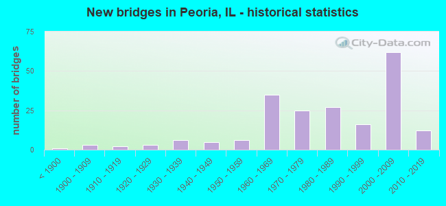
- New bridges - historical statistics
- 1Before 1900
- 31900-1909
- 21910-1919
- 31920-1929
- 61930-1939
- 51940-1949
- 61950-1959
- 351960-1969
- 251970-1979
- 271980-1989
- 161990-1999
- 622000-2009
- 122010-2019

- Reconstructed bridges - Historical Statistics
- 41970-1979
- 51980-1989
- 31990-1999
- 42000-2009
- 12010-2019


- Bridge Condition - Deck
- 5.8%Excellent
- 1.9%Very good
- 40.4%Good
- 36.5%Satisfactory
- 9.6%Fair
- 3.8%Poor
- 1.9%Serious
- 1.0%Critical

- Bridge Condition - Superstructure
- 11.1%Excellent
- 13.9%Very good
- 22.2%Good
- 22.2%Satisfactory
- 19.4%Fair
- 9.3%Poor
- 1.9%Serious
- 0.9%Critical

- Bridge Condition - Substructure
- 0.9%Excellent
- 13.9%Very good
- 30.6%Good
- 21.3%Satisfactory
- 23.1%Fair
- 8.3%Poor
- 1.9%Serious

- Bridge Condition - Channel
- 17.6%Very good
- 19.8%Good
- 28.6%Satisfactory
- 16.5%Fair
- 11.0%Poor
- 6.6%Serious

- Bridge Condition - Culverts
- 2.7%Very good
- 32.4%Good
- 29.7%Satisfactory
- 21.6%Fair
- 8.1%Poor
- 5.4%Serious
Find on map >> Show street view
Structure Number: 720176, Location: 0.75 MI W ILL RIVER (Lat: 40.702003, Lng: -89.593233), Route carried "under" structure: Other road , Year Built: 2006, Structure Length: 0. m, Average Daily Traffic: 5,200 (year 2017), Truck Traffic: 4%, Features Intersected: FAI 74 RP 24.11, Facility Carried by Structure: NB KNOXVILLE
Minimum Vertical Clearance: 4.88m (16.01ft), Kilometerpoint: 0.129, Lanes on structure: 5, Lanes under structure: 2, Material/Design: Prestressed concrete, Design/Construction: Box Beam or Girders - Multiple, Length of Maximum Span: 64.0m (210.0ft)
Find on map >> Show street view
Structure Number: 720177, Location: .75 MI W ILLINOIS R (Lat: 40.700608, Lng: -89.593728), Route carried "under" structure: Other road , Year Built: 2006, Structure Length: 0. m, Average Daily Traffic: 7,000 (year 2017), Truck Traffic: 9%, Features Intersected: GLEN OAK AVE, Facility Carried by Structure: EB I-74,RP F-2
Minimum Vertical Clearance: 4.42m (14.50ft), Kilometerpoint: 8.207, Lanes on structure: 5, Lanes under structure: 4, Material/Design: Steel, Design/Construction: Stringer/Multi-beam, Length of Maximum Span: 23.3m (76.4ft)
Find on map >> Show street view
Structure Number: 720178, Location: .75 MI W ILLINOIS R (Lat: 40.700650, Lng: -89.593606), Route carried "under" structure: Other road , Year Built: 2006, Structure Length: 0. m, Average Daily Traffic: 7,000 (year 2017), Truck Traffic: 9%, Features Intersected: GLEN OAK AVE, Facility Carried by Structure: WB I-74
Minimum Vertical Clearance: 4.42m (14.50ft), Kilometerpoint: 8.191, Lanes on structure: 3, Lanes under structure: 4, Material/Design: Steel continuous, Design/Construction: Stringer/Multi-beam, Length of Maximum Span: 23.3m (76.4ft)
Find on map >> Show street view
Structure Number: 720179, Location: SB US24 IN PEORIA (Lat: 40.694717, Lng: -89.587472), Route carried "under" structure: Interstate 74, Year Built: 2005, Structure Length: 0. m, Average Daily Traffic: 50,000 (year 2021), Truck Traffic: 6%, Features Intersected: I-74, Facility Carried by Structure: JEFFERSON ST-US 24
Minimum Vertical Clearance: 4.95m (16.24ft), Kilometerpoint: 152.948, Lanes on structure: 4, Lanes under structure: 7, Material/Design: Steel continuous, Design/Construction: Stringer/Multi-beam, Length of Maximum Span: 27.0m (88.6ft)
Find on map >> Show street view
Structure Number: 72018, Location: DOWNTOWN PEORIA (Lat: 40.694439, Lng: -89.587428), Route carried "under" structure: Other road , Year Built: 2006, Structure Length: 0. m, Average Daily Traffic: 5,100 (year 2017), Truck Traffic: 4%, Features Intersected: 74EB TO WASHINGTON, Facility Carried by Structure: FAYETTE RP TO 74EB
Minimum Vertical Clearance: 4.65m (15.26ft), Kilometerpoint: 0.290, Lanes on structure: 1, Lanes under structure: 2, Material/Design: Prestressed concrete, Design/Construction: Stringer/Multi-beam, Length of Maximum Span: 25.4m (83.3ft)
Find on map >> Show street view
Structure Number: 720181, Location: DOWNTOWN PEORIA (Lat: 40.693072, Lng: -89.585219), Route carried "under" structure: Other road , Year Built: 2005, Structure Length: 0. m, Average Daily Traffic: 4,600 (year 2017), Truck Traffic: 5%, Features Intersected: WASHINGTON TO 74WB, Facility Carried by Structure: WB74 TO ADAMS/WASH
Minimum Vertical Clearance: 4.62m (15.16ft), Kilometerpoint: 0.048, Lanes on structure: 2, Lanes under structure: 1, Material/Design: Concrete, Design/Construction: Frame, Length of Maximum Span: 76.0m (249.3ft)
Find on map >> Show street view
Structure Number: 720182, Location: OVER RMPS G-1,2,&3 (Lat: 40.693811, Lng: -89.586425), Route carried "under" structure: Interstate 74, Year Built: 2005, Structure Length: 0. m, Average Daily Traffic: 50,000 (year 2021), Truck Traffic: 6%, Features Intersected: I-74, Facility Carried by Structure: ADAMS ST
Minimum Vertical Clearance: 5.61m (18.41ft), Kilometerpoint: 153.109, Lanes on structure: 3, Lanes under structure: 4, Material/Design: Steel continuous, Design/Construction: Stringer/Multi-beam, Length of Maximum Span: 35.7m (117.1ft)
Find on map >> Show street view
Structure Number: 720183, Location: US 150 INTERCHANGE (Lat: 40.738467, Lng: -89.623922), Route carried "under" structure: Other road , Year Built: 2006, Structure Length: 0. m, Average Daily Traffic: 6,400 (year 2017), Truck Traffic: 5%, Features Intersected: FA 317 RP 19.99, Facility Carried by Structure: I 74 RPS20.97,21.5
Minimum Vertical Clearance: 4.75m (15.58ft), Kilometerpoint: 0.531, Lanes on structure: 2, Lanes under structure: 1, Material/Design: Prestressed concrete continuous, Design/Construction: Stringer/Multi-beam, Length of Maximum Span: 38.6m (126.6ft)
Find on map >> Show street view
Structure Number: 720183, Location: US 150 INTERCHANGE (Lat: 40.735311, Lng: -89.623883), Route carried "under" structure: Other road , Year Built: 2006, Structure Length: 0. m, Average Daily Traffic: 2,600 (year 2017), Truck Traffic: 5%, Features Intersected: FA 317 RP 19.99, Facility Carried by Structure: I 74 RPS20.97,21.5
Minimum Vertical Clearance: 4.65m (15.26ft), Kilometerpoint: 0.193, Lanes on structure: 2, Lanes under structure: 1, Material/Design: Prestressed concrete continuous, Design/Construction: Stringer/Multi-beam, Length of Maximum Span: 38.6m (126.6ft)
Find on map >> Show street view
Structure Number: 720183, Location: US 150 INTERCHANGE (Lat: 40.735072, Lng: -89.624144), Route carried "under" structure: Interstate 74, Year Built: 2006, Structure Length: 0. m, Average Daily Traffic: 26,500 (year 2021), Truck Traffic: 11%, Features Intersected: FA 317 RP 19.99
Minimum Vertical Clearance: 5.31m (17.42ft), Kilometerpoint: 146.462, Lanes on structure: 2, Lanes under structure: 4, Material/Design: Prestressed concrete continuous, Design/Construction: Stringer/Multi-beam, Length of Maximum Span: 38.6m (126.6ft)
Find on map >> Show street view
Structure Number: 720184, Location: .65 MI E UNIVERSITY (Lat: 40.706072, Lng: -89.601817), Route carried "under" structure: Interstate 74, Year Built: 2004, Structure Length: 0. m, Average Daily Traffic: 47,300 (year 2021), Truck Traffic: 7%, Features Intersected: I-74, Facility Carried by Structure: ELLIS AVE
Minimum Vertical Clearance: 5.56m (18.24ft), Kilometerpoint: 151.081, Lanes on structure: 2, Lanes under structure: 4, Material/Design: Prestressed concrete continuous, Design/Construction: Stringer/Multi-beam, Length of Maximum Span: 34.4m (112.9ft)
Find on map >> Show street view
Structure Number: 720185, Location: PERRY ST IN PEORIA (Lat: 40.697639, Lng: -89.590606), Route carried "under" structure: Interstate 74, Year Built: 2005, Structure Length: 0. m, Average Daily Traffic: 50,000 (year 2021), Truck Traffic: 6%, Features Intersected: I-74, Facility Carried by Structure: PERRY STREET
Minimum Vertical Clearance: 5.59m (18.34ft), Kilometerpoint: 152.546, Lanes on structure: 3, Lanes under structure: 8, Material/Design: Steel continuous, Design/Construction: Stringer/Multi-beam, Length of Maximum Span: 22.3m (73.2ft)
Find on map >> Show street view
Structure Number: 720186, Location: MONROE ST IN PEORIA (Lat: 40.696683, Lng: -89.589614), Route carried "under" structure: Interstate 74, Year Built: 2005, Structure Length: 0. m, Average Daily Traffic: 50,000 (year 2021), Truck Traffic: 6%, Features Intersected: I-74, Facility Carried by Structure: MONROE STREET
Minimum Vertical Clearance: 5.46m (17.91ft), Kilometerpoint: 152.690, Lanes on structure: 4, Lanes under structure: 6, Material/Design: Prestressed concrete continuous, Design/Construction: Stringer/Multi-beam, Length of Maximum Span: 18.7m (61.4ft)
Find on map >> Show street view
Structure Number: 720187, Location: MADISON AVE PEORIA (Lat: 40.695689, Lng: -89.588617), Route carried "under" structure: Interstate 74, Year Built: 2005, Structure Length: 0. m, Average Daily Traffic: 50,000 (year 2021), Truck Traffic: 6%, Features Intersected: I-74, Facility Carried by Structure: MADISON AVE
Minimum Vertical Clearance: 4.88m (16.01ft), Kilometerpoint: 152.771, Lanes on structure: 4, Lanes under structure: 7, Material/Design: Steel continuous, Design/Construction: Stringer/Multi-beam, Length of Maximum Span: 17.6m (57.7ft)
Find on map >> Show street view
Structure Number: 720189, Location: UNIVERSITY AVE INTER (Lat: 40.706911, Lng: -89.613161), Route carried "under" structure: Interstate 74, Year Built: 2004, Structure Length: 0. m, Average Daily Traffic: 47,300 (year 2021), Truck Traffic: 7%, Features Intersected: I74 & DRY RUN CREEK, Facility Carried by Structure: UNIVERSITY AVE
Minimum Vertical Clearance: 4.85m (15.91ft), Kilometerpoint: 150.132, Lanes on structure: 4, Lanes under structure: 6, Material/Design: Prestressed concrete continuous, Design/Construction: Stringer/Multi-beam, Length of Maximum Span: 35.8m (117.5ft)
Find on map >> Show street view
Structure Number: 72019, Location: US 150 INTERCHANGE (Lat: 40.738578, Lng: -89.623911), Route carried "under" structure: Other road , Year Built: 2006, Structure Length: 0. m, Average Daily Traffic: 6,400 (year 2017), Truck Traffic: 4%, Features Intersected: WAR MEMORIAL DR, Facility Carried by Structure: FA 317RP 19.99
Minimum Vertical Clearance: 4.70m (15.42ft), Kilometerpoint: 0.547, Lanes on structure: 2, Lanes under structure: 1, Material/Design: Prestressed concrete continuous, Design/Construction: Stringer/Multi-beam, Length of Maximum Span: 40.1m (131.6ft)
Find on map >> Show street view
Structure Number: 72019, Location: US 150 INTERCHANGE (Lat: 40.738247, Lng: -89.623364), Route carried "under" structure: US 150, Year Built: 2006, Structure Length: 0. m, Average Daily Traffic: 22,200 (year 2021), Truck Traffic: 3%, Features Intersected: WAR MEMORIAL DR, Facility Carried by Structure: FA 317RP 19.99
Minimum Vertical Clearance: 4.60m (15.09ft), Kilometerpoint: 136.823, Lanes on structure: 2, Lanes under structure: 4, Material/Design: Prestressed concrete continuous, Design/Construction: Stringer/Multi-beam, Length of Maximum Span: 40.1m (131.6ft)
Find on map >> Show street view
Structure Number: 720191, Location: .5 MI W US 150 INTER (Lat: 40.737644, Lng: -89.631539), Route carried "under" structure: Interstate 74, Year Built: 2004, Structure Length: 0. m, Average Daily Traffic: 26,500 (year 2021), Truck Traffic: 11%, Features Intersected: I-74, Facility Carried by Structure: STERLING AVE
Minimum Vertical Clearance: 4.11m (13.48ft), Kilometerpoint: 145.754, Lanes on structure: 6, Lanes under structure: 4, Material/Design: Prestressed concrete continuous, Design/Construction: Stringer/Multi-beam, Length of Maximum Span: 20.3m (66.6ft)
Find on map >> Show street view
Structure Number: 720192, Location: .3 MI E UNIVERSITY (Lat: 40.706847, Lng: -89.607056), Route carried "under" structure: Interstate 74, Year Built: 2004, Structure Length: 0. m, Average Daily Traffic: 47,300 (year 2021), Truck Traffic: 7%, Features Intersected: I-74 & DRY RUN CRK, Facility Carried by Structure: BROADWAY ST
Minimum Vertical Clearance: 4.65m (15.26ft), Kilometerpoint: 150.630, Lanes on structure: 2, Lanes under structure: 4, Material/Design: Steel continuous, Design/Construction: Stringer/Multi-beam, Length of Maximum Span: 36.4m (119.4ft)
Find on map >> Show street view
Structure Number: 720193, Location: .5 MI E UNIVERSITY (Lat: 40.706411, Lng: -89.603600), Route carried "under" structure: Interstate 74, Year Built: 2004, Structure Length: 0. m, Average Daily Traffic: 47,300 (year 2021), Truck Traffic: 7%, Features Intersected: I-74, Facility Carried by Structure: SHERIDAN ROAD
Minimum Vertical Clearance: 5.46m (17.91ft), Kilometerpoint: 150.952, Lanes on structure: 4, Lanes under structure: 4, Material/Design: Prestressed concrete continuous, Design/Construction: Stringer/Multi-beam, Length of Maximum Span: 28.8m (94.5ft)
Find on map >> Show street view
Structure Number: 720194, Location: .75 MI E UNIVERSITY (Lat: 40.704867, Lng: -89.596553), Route carried "under" structure: Interstate 74, Year Built: 2002, Structure Length: 0. m, Average Daily Traffic: 47,300 (year 2021), Truck Traffic: 7%, Features Intersected: I-74, Facility Carried by Structure: NORTH ST
Minimum Vertical Clearance: 5.18m (16.99ft), Kilometerpoint: 151.516, Lanes on structure: 2, Lanes under structure: 4, Material/Design: Steel continuous, Design/Construction: Stringer/Multi-beam, Length of Maximum Span: 38.9m (127.6ft)
Find on map >> Show street view
Structure Number: 720195, Location: GALE AVE INTERCHANGE (Lat: 40.720639, Lng: -89.621431), Route carried "under" structure: Interstate 74, Year Built: 2004, Structure Length: 0. m, Average Daily Traffic: 42,200 (year 2021), Truck Traffic: 6%, Features Intersected: I-74, Facility Carried by Structure: N GALE AVE
Minimum Vertical Clearance: 5.13m (16.83ft), Kilometerpoint: 148.217, Lanes on structure: 4, Lanes under structure: 4, Material/Design: Steel continuous, Design/Construction: Stringer/Multi-beam, Length of Maximum Span: 36.9m (121.1ft)
Find on map >> Show street view
Structure Number: 720196, Location: 3/8 MI N GALE INTER (Lat: 40.725261, Lng: -89.619819), Route carried "under" structure: Interstate 74, Year Built: 2003, Structure Length: 0. m, Average Daily Traffic: 38,800 (year 2021), Truck Traffic: 7%, Features Intersected: I-74, Facility Carried by Structure: FORREST HILL AVE
Minimum Vertical Clearance: 5.16m (16.93ft), Kilometerpoint: 147.637, Lanes on structure: 4, Lanes under structure: 4, Material/Design: Prestressed concrete continuous, Design/Construction: Stringer/Multi-beam, Length of Maximum Span: 27.9m (91.5ft)
Find on map >> Show street view
Structure Number: 720197, Location: .5 MI W UNIVERSITY (Lat: 40.710353, Lng: -89.620694), Route carried "under" structure: Interstate 74, Year Built: 2006, Structure Length: 0. m, Average Daily Traffic: 42,200 (year 2021), Truck Traffic: 6%, Features Intersected: I-74, Facility Carried by Structure: NEBRASKA AVE
Minimum Vertical Clearance: 5.33m (17.49ft), Kilometerpoint: 149.359, Lanes on structure: 4, Lanes under structure: 6, Material/Design: Prestressed concrete continuous, Design/Construction: Stringer/Multi-beam, Length of Maximum Span: 26.5m (86.9ft)
Find on map >> Show street view
Structure Number: 726015, Location: NE1/4Sec8 T18N R8E (Lat: 40.693439, Lng: -89.608669), Route carried "under" structure: Other road , Year Built: 2018, Structure Length: 0. m, Average Daily Traffic: 2,700 (year 2017), Truck Traffic: 4%, Features Intersected: R B GARRETT AVE, Facility Carried by Structure: MACARTHUR HWY
Minimum Vertical Clearance: 4.29m (14.07ft), Kilometerpoint: 0.145, Lanes on structure: 2, Lanes under structure: 3, Material/Design: Concrete, Design/Construction: Stringer/Multi-beam, Length of Maximum Span: 19.2m (63.0ft)
Find on map >> Show street view
Structure Number: 729905, Location: PEORIA JOURNAL BLDG. (Lat: 40.724656, Lng: -89.560819), Route carried "under" structure: US 150, Year Built: 1950, Structure Length: 0. m, Average Daily Traffic: 25,800 (year 2021), Truck Traffic: 4%, Features Intersected: US 150, Facility Carried by Structure: P&PU RR (604054B)
Minimum Vertical Clearance: 4.27m (14.01ft), Kilometerpoint: 142.648, Lanes under structure: 5, Material/Design: Steel, Design/Construction: Stringer/Multi-beam, Length of Maximum Span: 21.3m (69.9ft)
Find on map >> Show street view
Structure Number: 72992, Location: MP 73.9 (Lat: 40.757614, Lng: -89.647047), Route carried "under" structure: Other road , Year Built: 2006, Structure Length: 0. m, Average Daily Traffic: 9,250 (year 2017), Truck Traffic: 2%, Features Intersected: CHARTER OAK ROAD, Facility Carried by Structure: UP 748462K
Minimum Vertical Clearance: 30.18m (99.02ft), Kilometerpoint: 3.717, Lanes under structure: 4, Material/Design: Steel, Design/Construction: Stringer/Multi-beam, Length of Maximum Span: 24.7m (81.0ft)
Find on map >> Show street view
Structure Number: 900001, Location: I-74 OVR ILLINOIS R (Lat: 40.692483, Lng: -89.585411), Route carried "under" structure: Other road , Year Built: 1958, Structure Length: 0. m, Average Daily Traffic: 6,650 (year 2017), Truck Traffic: 11%, Features Intersected: ILL RIV (604034P), Facility Carried by Structure: I-74
Minimum Vertical Clearance: 4.65m (15.26ft), Kilometerpoint: 0.209, Lanes on structure: 4, Lanes under structure: 4, Material/Design: Steel continuous, Design/Construction: Truss - Thru, Length of Maximum Span: 182.9m (600.1ft)
Find on map >> Show street view
Structure Number: 900122, Location: Bob Michel Bridge (Lat: 40.687475, Lng: -89.593825), Route carried "under" structure: Other road , Year Built: 1993, Structure Length: 0. m, Average Daily Traffic: 6,850 (year 2017), Truck Traffic: 8%, Features Intersected: IL RIV,WASH.ST.&RR'S, Facility Carried by Structure: IL 40
Minimum Vertical Clearance: 5.33m (17.49ft), Kilometerpoint: 17.252, Lanes on structure: 4, Lanes under structure: 6, Material/Design: Steel continuous, Design/Construction: Stringer/Multi-beam, Length of Maximum Span: 109.7m (359.9ft)
Find on map >> Show street view
Structure Number: 900122, Location: Bob Michel Bridge (Lat: 40.686492, Lng: -89.593069), Route carried "under" structure: City street , Year Built: 1993, Structure Length: 0. m, Average Daily Traffic: 1,250 (year 2017), Truck Traffic: 5%, Features Intersected: IL RIV,WASH.ST.&RR'S, Facility Carried by Structure: IL 40
Minimum Vertical Clearance: 12.50m (41.01ft), Kilometerpoint: 0.241, Lanes on structure: 4, Lanes under structure: 2, Material/Design: Steel continuous, Design/Construction: Stringer/Multi-beam, Length of Maximum Span: 109.7m (359.9ft)