Bridge Statistics for South Bend, Indiana (IN)
Condition, Traffic, Stress, Structural Evaluation, Project Costs
- National Bridge Inventory (NBI) Statistics
- 244Number of bridges
- 2,270ft / 692mTotal length
- $15,519,000Total costs
- 2,412,481Total average daily traffic
- 318,541Total average daily truck traffic
- National Bridge Inventory (NBI) Registered Bridges for South Bend
- No street view available for this location
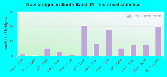
- New bridges - historical statistics
- 31900-1909
- 11910-1919
- 131920-1929
- 71930-1939
- 21940-1949
- 521950-1959
- 211960-1969
- 441970-1979
- 131980-1989
- 191990-1999
- 192000-2009
- 502010-2019
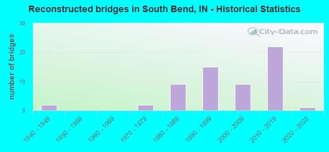
- Reconstructed bridges - Historical Statistics
- 21940-1949
- 01950-1959
- 01960-1969
- 21970-1979
- 91980-1989
- 151990-1999
- 92000-2009
- 222010-2019
- 12020-2022
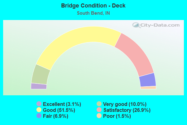
- Bridge Condition - Deck
- 3.1%Excellent
- 10.0%Very good
- 51.5%Good
- 26.9%Satisfactory
- 6.9%Fair
- 1.5%Poor
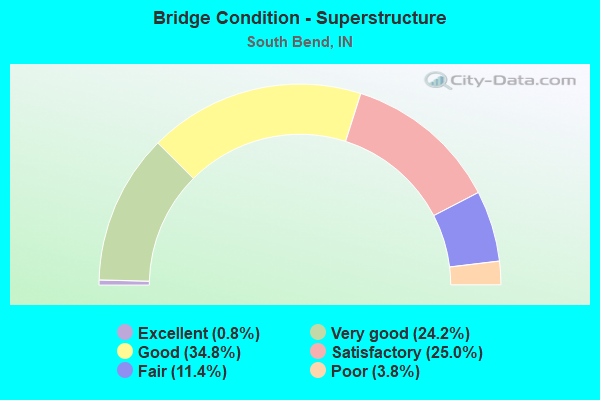
- Bridge Condition - Superstructure
- 0.8%Excellent
- 24.2%Very good
- 34.8%Good
- 25.0%Satisfactory
- 11.4%Fair
- 3.8%Poor
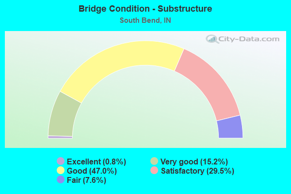
- Bridge Condition - Substructure
- 0.8%Excellent
- 15.2%Very good
- 47.0%Good
- 29.5%Satisfactory
- 7.6%Fair
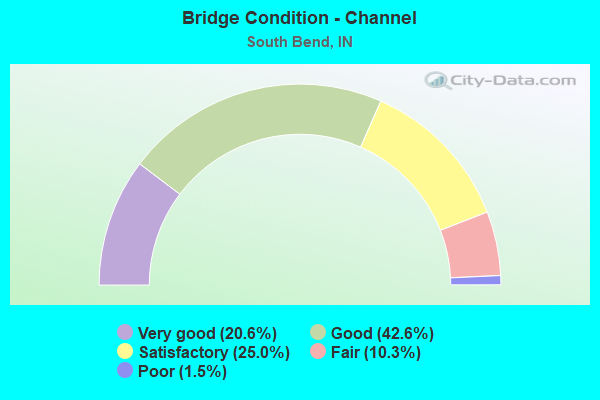
- Bridge Condition - Channel
- 20.6%Very good
- 42.6%Good
- 25.0%Satisfactory
- 10.3%Fair
- 1.5%Poor
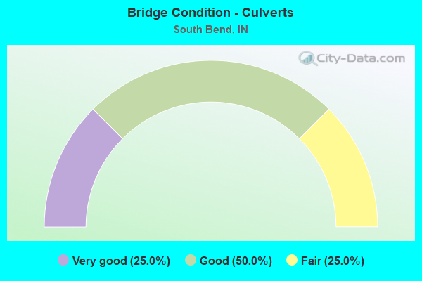
- Bridge Condition - Culverts
- 25.0%Very good
- 50.0%Good
- 25.0%Fair
Find on map >> Show street view
Structure Number: 100001, Location: 0.10 N OF CR 1100 N (Lat: 40.904939, Lng: -85.063919), Route carried "on" structure: County highway 103, Year Built: 2007, Status: Open, Structure Length: 1.74m (5.71ft), Average Daily Traffic: 100 (year 2016), Truck Traffic: 5%, Average Future Daily Traffic: 175 (year 2036), Design Load: HS 20, Features Intersected: LAMBERT #1 DITCH, Facility Carried by Structure: CR 650 WEST
Minimum Vertical Clearance: 30+ m (98+ ft), Kilometerpoint: 0.000, Lanes on structure: 2, Owner: County Highway Agency, Approaching Roadway Width: 5.8m (19.0ft), Skew: 1 degrees, Material/Design: Prestressed concrete, Design/Construction: Box Beam or Girders - Multiple, Number Of Spans In Main Unit: 1, Length of Maximum Span: 16.5m (54.1ft), Curb-To-Curb Width: 8.4m (27.6ft), Out-to-Out Width: 8.6m (28.2ft)
Condition: Deck: Good, Superstructure: Good, Substructure: Very good, Channel: Very good, Operating Rating: 78.1 metric tons, Method Used To Determine Operating Rating: Load Factor (LF), Inventory Rating: 46.8 metric tons, Method Used To Determine Inventory Rating: Load Factor (LF), Structural Evaluation: Better than present minimum criteria, Deck Geometry: Equal to present minimum criteria, Waterway Adequacy: Better than present minimum criteria, Approach Roadway Alignment: Equal to present minimum criteria, Designated Inspection Frequency: Every 24 months, Inspection Date: May 2020, Deck Structure Type: Concrete Cast-file-Place, Wearing Surface/Protective System: Wearing Surface: Monolithic Concrete, Deck Protection: Epoxy Coated Reinforcing
Find on map >> Show street view
Structure Number: 100021, Location: 0.20 E OF CR 100 E (Lat: 40.876561, Lng: -84.914181), Route carried "on" structure: County highway 900, Year Built: 1976, Status: Open, Structure Length: 1.48m (4.86ft), Average Daily Traffic: 450 (year 2016), Truck Traffic: 5%, Average Future Daily Traffic: 675 (year 2036), Design Load: HS 20, Features Intersected: GERKE DITCH
Minimum Vertical Clearance: 30+ m (98+ ft), Kilometerpoint: 0.000, Lanes on structure: 2, Owner: County Highway Agency, Approaching Roadway Width: 5.2m (17.1ft), Material/Design: Prestressed concrete, Design/Construction: Box Beam or Girders - Multiple, Number Of Spans In Main Unit: 1, Length of Maximum Span: 14.0m (45.9ft), Curb-To-Curb Width: 7.2m (23.6ft), Out-to-Out Width: 7.3m (24.0ft)
Condition: Deck: Satisfactory, Superstructure: Satisfactory, Substructure: Satisfactory, Channel: Fair, Operating Rating: 57.4 metric tons, Method Used To Determine Operating Rating: Load Factor (LF), Inventory Rating: 34.4 metric tons, Method Used To Determine Inventory Rating: Load Factor (LF), Structural Evaluation: Equal to present minimum criteria, Deck Geometry: Meets minimum limits, Waterway Adequacy: Better than present minimum criteria, Approach Roadway Alignment: Equal to present desirable criteria, Designated Inspection Frequency: Every 24 months, Inspection Date: May 2020, Deck Structure Type: Concrete Precast Panels, Wearing Surface/Protective System: Wearing Surface: Bituminous
Find on map >> Show street view
Structure Number: 100049, Location: 0.10 W OF US 27 (Lat: 40.803069, Lng: -84.939750), Route carried "on" structure: County highway 126, Year Built: 1983, Status: Open, Structure Length: 0.79m (2.59ft), Average Daily Traffic: 166 (year 2019), Truck Traffic: 5%, Average Future Daily Traffic: 112 (year 2039), Design Load: HS 20, Features Intersected: BORUM RUN, Facility Carried by Structure: CR 400 NORTH
Minimum Vertical Clearance: 30+ m (98+ ft), Kilometerpoint: 0.000, Lanes on structure: 2, Owner: County Highway Agency, Approaching Roadway Width: 7.3m (24.0ft), Skew: 2 degrees, Material/Design: Prestressed concrete, Design/Construction: Box Beam or Girders - Multiple, Number Of Spans In Main Unit: 1, Length of Maximum Span: 7.3m (24.0ft), Curb-To-Curb Width: 7.2m (23.6ft), Out-to-Out Width: 7.3m (24.0ft)
Condition: Deck: Satisfactory, Superstructure: Satisfactory, Substructure: Satisfactory, Channel: Fair, Operating Rating: 49.3 metric tons, Method Used To Determine Operating Rating: Load Factor (LF), Inventory Rating: 29.5 metric tons, Method Used To Determine Inventory Rating: Load Factor (LF), Structural Evaluation: Equal to present minimum criteria, Deck Geometry: Meets minimum limits, Waterway Adequacy: Better than present minimum criteria, Approach Roadway Alignment: Equal to present minimum criteria, Designated Inspection Frequency: Every 24 months, Inspection Date: May 2020, Deck Structure Type: Concrete Precast Panels
Find on map >> Show street view
Structure Number: 100064, Location: 0.10 E OF CR 400 E (Lat: 40.775500, Lng: -84.858661), Route carried "on" structure: County highway 50, Year Built: 2006, Status: Open, Structure Length: 1.51m (4.95ft), Average Daily Traffic: 63 (year 2016), Truck Traffic: 2%, Average Future Daily Traffic: 94 (year 2036), Design Load: HS 20, Features Intersected: MARTZ CREEK, Facility Carried by Structure: CR 200 NORTH
Minimum Vertical Clearance: 30+ m (98+ ft), Kilometerpoint: 0.000, Lanes on structure: 2, Owner: County Highway Agency, Approaching Roadway Width: 6.1m (20.0ft), Material/Design: Prestressed concrete, Design/Construction: Box Beam or Girders - Multiple, Number Of Spans In Main Unit: 1, Length of Maximum Span: 14.1m (46.3ft), Curb-To-Curb Width: 8.4m (27.6ft), Out-to-Out Width: 8.6m (28.2ft)
Condition: Deck: Good, Superstructure: Very good, Substructure: Good, Channel: Good, Operating Rating: 66.4 metric tons, Method Used To Determine Operating Rating: Load Factor (LF), Inventory Rating: 39.7 metric tons, Method Used To Determine Inventory Rating: Load Factor (LF), Structural Evaluation: Better than present minimum criteria, Deck Geometry: Equal to present minimum criteria, Waterway Adequacy: Equal to present desirable criteria, Approach Roadway Alignment: Equal to present desirable criteria, Designated Inspection Frequency: Every 24 months, Inspection Date: June 2020, Deck Structure Type: Concrete Cast-file-Place, Wearing Surface/Protective System: Wearing Surface: Latex Concrete
Find on map >> Show street view
Structure Number: 100069, Location: 0.20 S OF CR 100 N (Lat: 40.757661, Lng: -84.918119), Route carried "on" structure: County highway 47, Year Built: 2006, Status: Open, Structure Length: 1.68m (5.51ft), Average Daily Traffic: 651 (year 2019), Truck Traffic: 5%, Average Future Daily Traffic: 448 (year 2039), Design Load: HS 20, Features Intersected: YELLOW CREEK, Facility Carried by Structure: CR 100 EAST
Minimum Vertical Clearance: 30+ m (98+ ft), Kilometerpoint: 0.000, Lanes on structure: 2, Owner: County Highway Agency, Approaching Roadway Width: 6.1m (20.0ft), Material/Design: Prestressed concrete, Design/Construction: Box Beam or Girders - Multiple, Number Of Spans In Main Unit: 1, Length of Maximum Span: 15.8m (51.8ft), Curb-To-Curb Width: 8.4m (27.6ft), Out-to-Out Width: 8.5m (27.9ft)
Condition: Deck: Satisfactory, Superstructure: Good, Substructure: Very good, Channel: Good, Operating Rating: 77.2 metric tons, Method Used To Determine Operating Rating: Load Factor (LF), Inventory Rating: 46.2 metric tons, Method Used To Determine Inventory Rating: Load Factor (LF), Structural Evaluation: Better than present minimum criteria, Deck Geometry: Somewhat better than minimum adequacy, Waterway Adequacy: Equal to present desirable criteria, Approach Roadway Alignment: Equal to present desirable criteria, Designated Inspection Frequency: Every 24 months, Inspection Date: June 2020, Deck Structure Type: Concrete Cast-file-Place, Wearing Surface/Protective System: Wearing Surface: Monolithic Concrete
Find on map >> Show street view
Structure Number: 100074, Location: 0.20 W OF CR 500 W (Lat: 40.728569, Lng: -85.036219), Route carried "on" structure: County highway 44, Year Built: 1970, Year Reconstructed: 2013, Status: Open, Structure Length: 0.76m (2.49ft), Average Daily Traffic: 100 (year 2016), Truck Traffic: 5%, Average Future Daily Traffic: 150 (year 2036), Design Load: HS 20, Features Intersected: BLUE CREEK, Facility Carried by Structure: CR 100 SOUTH
Minimum Vertical Clearance: 30+ m (98+ ft), Kilometerpoint: 0.000, Lanes on structure: 2, Owner: County Highway Agency, Approaching Roadway Width: 6.4m (21.0ft), Material/Design: Prestressed concrete, Design/Construction: Box Beam or Girders - Multiple, Number Of Spans In Main Unit: 1, Length of Maximum Span: 6.9m (22.6ft), Curb-To-Curb Width: 8.4m (27.6ft), Out-to-Out Width: 8.5m (27.9ft)
Condition: Deck: Very good, Superstructure: Very good, Substructure: Good, Channel: Very good, Operating Rating: 99.3 metric tons, Method Used To Determine Operating Rating: Load Factor (LF), Inventory Rating: 59.4 metric tons, Method Used To Determine Inventory Rating: Load Factor (LF), Structural Evaluation: Better than present minimum criteria, Deck Geometry: Equal to present minimum criteria, Waterway Adequacy: Somewhat better than minimum adequacy, Approach Roadway Alignment: Equal to present desirable criteria, Designated Inspection Frequency: Every 24 months, Inspection Date: June 2020, Deck Structure Type: Concrete Cast-file-Place, Wearing Surface/Protective System: Wearing Surface: Monolithic Concrete, Deck Protection: Epoxy Coated Reinforcing
Find on map >> Show street view
Structure Number: 10008, Location: 0.10 S OF CR 200 S (Lat: 40.713339, Lng: -84.975100), Route carried "on" structure: County highway 200, Year Built: 2008, Status: Open, Structure Length: 2.19m (7.19ft), Average Daily Traffic: 100 (year 2016), Truck Traffic: 5%, Average Future Daily Traffic: 150 (year 2036), Design Load: HS 20, Features Intersected: BLUE CREEK
Minimum Vertical Clearance: 30+ m (98+ ft), Kilometerpoint: 0.000, Lanes on structure: 2, Owner: County Highway Agency, Approaching Roadway Width: 6.1m (20.0ft), Skew: 3 degrees, Material/Design: Prestressed concrete continuous, Design/Construction: Box Beam or Girders - Multiple, Number Of Spans In Main Unit: 3, Length of Maximum Span: 8.8m (28.9ft), Curb-To-Curb Width: 8.4m (27.6ft), Out-to-Out Width: 8.4m (27.6ft)
Condition: Deck: Good, Superstructure: Very good, Substructure: Good, Channel: Good, Operating Rating: 69.9 metric tons, Method Used To Determine Operating Rating: Load Factor (LF), Inventory Rating: 41.9 metric tons, Method Used To Determine Inventory Rating: Load Factor (LF), Structural Evaluation: Better than present minimum criteria, Deck Geometry: Equal to present minimum criteria, Waterway Adequacy: Better than present minimum criteria, Approach Roadway Alignment: Equal to present desirable criteria, Designated Inspection Frequency: Every 24 months, Inspection Date: June 2020, Deck Structure Type: Concrete Cast-file-Place, Wearing Surface/Protective System: Wearing Surface: Monolithic Concrete, Deck Protection: Epoxy Coated Reinforcing
Find on map >> Show street view
Structure Number: 100081, Location: 0.10 N OF CR 300 S (Lat: 40.703239, Lng: -84.936711), Route carried "on" structure: County highway , Year Built: 1959, Status: Open, Structure Length: 1.87m (6.14ft), Average Daily Traffic: 1,575 (year 2016), Truck Traffic: 5%, Average Future Daily Traffic: 2,340 (year 2036), Features Intersected: BLUE CREEK, Facility Carried by Structure: CR 000 E/W
Minimum Vertical Clearance: 30+ m (98+ ft), Kilometerpoint: 0.000, Lanes on structure: 2, Owner: County Highway Agency, Approaching Roadway Width: 6.7m (22.0ft), Material/Design: Concrete continuous, Design/Construction: Slab, Number Of Spans In Main Unit: 3, Length of Maximum Span: 7.1m (23.3ft), Curb-To-Curb Width: 6.7m (22.0ft), Out-to-Out Width: 8.5m (27.9ft)
Condition: Deck: Good, Superstructure: Good, Substructure: Satisfactory, Channel: Good, Operating Rating: 51.4 metric tons, Method Used To Determine Operating Rating: Load Factor (LF), Inventory Rating: 30.8 metric tons, Method Used To Determine Inventory Rating: Load Factor (LF), Structural Evaluation: Equal to present minimum criteria, Deck Geometry: High priority of corrective action, Waterway Adequacy: Better than present minimum criteria, Approach Roadway Alignment: Equal to present desirable criteria, Designated Inspection Frequency: Every 24 months, Inspection Date: June 2020, Deck Structure Type: Concrete Cast-file-Place, Wearing Surface/Protective System: Wearing Surface: Latex Concrete
Find on map >> Show street view
Structure Number: 100082, Location: 0.70 E OF CR 500 E (Lat: 40.718061, Lng: -84.827031), Route carried "on" structure: County highway 200, Year Built: 1946, Year Reconstructed: 2004, Status: Posted for load, Structure Length: 2.36m (7.74ft), Average Daily Traffic: 100 (year 2016), Truck Traffic: 5%, Average Future Daily Traffic: 165 (year 2036), Features Intersected: BLUE CREEK
Minimum Vertical Clearance: 30+ m (98+ ft), Kilometerpoint: 0.000, Lanes on structure: 2, Owner: County Highway Agency, Approaching Roadway Width: 5.2m (17.1ft), Material/Design: Steel, Design/Construction: Truss - Thru, Number Of Spans In Main Unit: 1, Length of Maximum Span: 21.6m (70.9ft), Curb or Sidewalk Widths: Left: 0.2m (0.7ft), Right: 0.2m (0.7ft), Curb-To-Curb Width: 5.3m (17.4ft), Out-to-Out Width: 5.6m (18.4ft)
Condition: Deck: Satisfactory, Superstructure: Satisfactory, Substructure: Fair, Channel: Satisfactory, Operating Rating: 15.4 metric tons, Method Used To Determine Operating Rating: Load Factor (LF), Inventory Rating: 9.2 metric tons, Method Used To Determine Inventory Rating: Load Factor (LF), Structural Evaluation: High priority of replacement, Deck Geometry: High priority of corrective action, Waterway Adequacy: Better than present minimum criteria, Approach Roadway Alignment: Equal to present minimum criteria, Bridge Posting: Required (Relationship of Operating Rating to Maximum Legal Load: > 39.9% below), Length Of Structure Improvement: 3.20m (10.50ft), Designated Inspection Frequency: Every 24 months, Critical Feature Inspection Frequency: Every 24 months, Inspection Date: June 2020, Critical Feature Inspection Date: June 2020, Bridge Improvement Cost: $500,000, Roadway Improvement Cost: $200,000, Total Project Cost: $700,000 ( Estimate for 2020), Deck Structure Type: Concrete Cast-file-Place, Wearing Surface/Protective System: Wearing Surface: Monolithic Concrete
Find on map >> Show street view
Structure Number: 100086, Location: 0.10 S OF CR 350 S (Lat: 40.694139, Lng: -84.879150), Route carried "on" structure: County highway 300, Year Built: 2003, Status: Open, Structure Length: 2.48m (8.14ft), Average Daily Traffic: 100 (year 2016), Truck Traffic: 5%, Average Future Daily Traffic: 175 (year 2036), Design Load: HS 20, Features Intersected: BLUE CREEK
Minimum Vertical Clearance: 30+ m (98+ ft), Kilometerpoint: 0.000, Lanes on structure: 2, Owner: County Highway Agency, Approaching Roadway Width: 6.7m (22.0ft), Skew: 1 degrees, Material/Design: Prestressed concrete, Design/Construction: Stringer/Multi-beam, Number Of Spans In Main Unit: 1, Length of Maximum Span: 23.7m (77.8ft), Curb-To-Curb Width: 8.0m (26.2ft), Out-to-Out Width: 8.1m (26.6ft)
Condition: Deck: Good, Superstructure: Very good, Substructure: Good, Channel: Good, Operating Rating: 73.2 metric tons, Method Used To Determine Operating Rating: Load Factor (LF), Inventory Rating: 35.4 metric tons, Method Used To Determine Inventory Rating: Load Factor (LF), Structural Evaluation: Better than present minimum criteria, Deck Geometry: Equal to present minimum criteria, Waterway Adequacy: Superior to present desirable criteria, Approach Roadway Alignment: Equal to present desirable criteria, Designated Inspection Frequency: Every 24 months, Inspection Date: June 2020, Deck Structure Type: Concrete Cast-file-Place, Wearing Surface/Protective System: Wearing Surface: Monolithic Concrete, Deck Protection: Epoxy Coated Reinforcing
Find on map >> Show street view
Structure Number: 100087, Location: 0.20 N OF CR 400 S (Lat: 40.690181, Lng: -84.898139), Route carried "on" structure: County highway 200, Year Built: 1930, Year Reconstructed: 1988, Status: Open, Structure Length: 1.23m (4.04ft), Average Daily Traffic: 410 (year 2016), Truck Traffic: 5%, Average Future Daily Traffic: 620 (year 2036), Design Load: HS 20, Features Intersected: BLUE CREEK
Minimum Vertical Clearance: 30+ m (98+ ft), Kilometerpoint: 0.000, Lanes on structure: 2, Owner: County Highway Agency, Approaching Roadway Width: 5.5m (18.0ft), Material/Design: Prestressed concrete, Design/Construction: Box Beam or Girders - Multiple, Number Of Spans In Main Unit: 1, Length of Maximum Span: 8.9m (29.2ft), Curb-To-Curb Width: 7.2m (23.6ft), Out-to-Out Width: 7.3m (24.0ft)
Condition: Deck: Satisfactory, Superstructure: Satisfactory, Substructure: Satisfactory, Channel: Fair, Operating Rating: 52.0 metric tons, Method Used To Determine Operating Rating: Load Factor (LF), Inventory Rating: 31.1 metric tons, Method Used To Determine Inventory Rating: Load Factor (LF), Structural Evaluation: Equal to present minimum criteria, Deck Geometry: Meets minimum limits, Waterway Adequacy: Better than present minimum criteria, Approach Roadway Alignment: Equal to present desirable criteria, Designated Inspection Frequency: Every 24 months, Inspection Date: June 2020, Deck Structure Type: Concrete Precast Panels, Wearing Surface/Protective System: Wearing Surface: Bituminous
Find on map >> Show street view
Structure Number: 100089, Location: 0.10 N OF CR 350 S (Lat: 40.697411, Lng: -84.917281), Route carried "on" structure: County highway 100, Year Built: 1995, Status: Open, Structure Length: 2.41m (7.91ft), Average Daily Traffic: 100 (year 2016), Truck Traffic: 5%, Average Future Daily Traffic: 175 (year 2036), Design Load: HS 20, Features Intersected: BLUE CREEK
Minimum Vertical Clearance: 30+ m (98+ ft), Kilometerpoint: 0.000, Lanes on structure: 2, Owner: County Highway Agency, Approaching Roadway Width: 5.5m (18.0ft), Material/Design: Prestressed concrete continuous, Design/Construction: Box Beam or Girders - Multiple, Number Of Spans In Main Unit: 3, Length of Maximum Span: 8.0m (26.2ft), Curb-To-Curb Width: 7.2m (23.6ft), Out-to-Out Width: 7.3m (24.0ft)
Condition: Deck: Satisfactory, Superstructure: Very good, Substructure: Good, Channel: Good, Operating Rating: 85.2 metric tons, Method Used To Determine Operating Rating: Load Factor (LF), Inventory Rating: 51.0 metric tons, Method Used To Determine Inventory Rating: Load Factor (LF), Structural Evaluation: Better than present minimum criteria, Deck Geometry: Somewhat better than minimum adequacy, Waterway Adequacy: Equal to present desirable criteria, Approach Roadway Alignment: Equal to present desirable criteria, Designated Inspection Frequency: Every 24 months, Inspection Date: June 2020, Deck Structure Type: Concrete Cast-file-Place, Wearing Surface/Protective System: Wearing Surface: Monolithic Concrete
Find on map >> Show street view
Structure Number: 1001, Location: 0.10 W OF CR 600 E (Lat: 40.688931, Lng: -84.825189), Route carried "on" structure: County highway 400, Year Built: 1991, Status: Open, Structure Length: 0.91m (2.99ft), Average Daily Traffic: 100 (year 2016), Truck Traffic: 5%, Average Future Daily Traffic: 165 (year 2036), Design Load: HS 20, Features Intersected: LUGINBILL DITCH
Minimum Vertical Clearance: 30+ m (98+ ft), Kilometerpoint: 0.000, Lanes on structure: 2, Owner: County Highway Agency, Approaching Roadway Width: 5.5m (18.0ft), Material/Design: Prestressed concrete, Design/Construction: Box Beam or Girders - Multiple, Number Of Spans In Main Unit: 1, Length of Maximum Span: 8.1m (26.6ft), Curb-To-Curb Width: 7.2m (23.6ft), Out-to-Out Width: 7.3m (24.0ft)
Condition: Deck: Good, Superstructure: Good, Substructure: Good, Channel: Satisfactory, Operating Rating: 64.1 metric tons, Method Used To Determine Operating Rating: Load Factor (LF), Inventory Rating: 38.4 metric tons, Method Used To Determine Inventory Rating: Load Factor (LF), Structural Evaluation: Better than present minimum criteria, Deck Geometry: Somewhat better than minimum adequacy, Waterway Adequacy: Better than present minimum criteria, Approach Roadway Alignment: Equal to present desirable criteria, Designated Inspection Frequency: Every 24 months, Inspection Date: June 2020, Deck Structure Type: Concrete Precast Panels, Wearing Surface/Protective System: Wearing Surface: Bituminous
Find on map >> Show street view
Structure Number: 100103, Location: 0.20 W OF CR 525 E (Lat: 40.674089, Lng: -84.839150), Route carried "on" structure: County highway 500, Year Built: 1976, Status: Posted for load, Structure Length: 1.89m (6.20ft), Average Daily Traffic: 100 (year 2016), Truck Traffic: 5%, Average Future Daily Traffic: 175 (year 2036), Design Load: HS 20, Features Intersected: LUGINBILL DITCH
Minimum Vertical Clearance: 30+ m (98+ ft), Kilometerpoint: 0.000, Lanes on structure: 2, Owner: County Highway Agency, Approaching Roadway Width: 5.2m (17.1ft), Skew: 1 degrees, Material/Design: Concrete continuous, Design/Construction: Slab, Number Of Spans In Main Unit: 3, Length of Maximum Span: 7.3m (24.0ft), Curb-To-Curb Width: 7.9m (25.9ft), Out-to-Out Width: 8.8m (28.9ft)
Condition: Deck: Satisfactory, Superstructure: Satisfactory, Substructure: Satisfactory, Channel: Fair, Operating Rating: 47.4 metric tons, Method Used To Determine Operating Rating: Load Factor (LF), Inventory Rating: 28.4 metric tons, Method Used To Determine Inventory Rating: Load Factor (LF), Structural Evaluation: Equal to present minimum criteria, Deck Geometry: Equal to present minimum criteria, Waterway Adequacy: Better than present minimum criteria, Approach Roadway Alignment: Equal to present desirable criteria, Designated Inspection Frequency: Every 24 months, Inspection Date: June 2020, Deck Structure Type: Concrete Cast-file-Place, Wearing Surface/Protective System: Wearing Surface: Latex Concrete
Find on map >> Show street view
Structure Number: 10011, Location: 0.30 N OF CR 700 S (Lat: 40.643839, Lng: -85.030831), Route carried "on" structure: County highway 500, Year Built: 1967, Status: Open, Structure Length: 6.92m (22.70ft), Average Daily Traffic: 925 (year 2016), Truck Traffic: 10%, Average Future Daily Traffic: 1,375 (year 2036), Design Load: HS 20, Features Intersected: WABASH RIVER
Minimum Vertical Clearance: 30+ m (98+ ft), Kilometerpoint: 0.000, Lanes on structure: 2, Owner: County Highway Agency, Approaching Roadway Width: 7.3m (24.0ft), Material/Design: Prestressed concrete, Design/Construction: Stringer/Multi-beam, Number Of Spans In Main Unit: 3, Length of Maximum Span: 22.9m (75.1ft), Curb or Sidewalk Widths: Left: 0.3m (1.0ft), Right: 0.3m (1.0ft), Curb-To-Curb Width: 8.3m (27.2ft), Out-to-Out Width: 9.4m (30.8ft)
Condition: Deck: Good, Superstructure: Good, Substructure: Good, Channel: Satisfactory, Operating Rating: 60.2 metric tons, Method Used To Determine Operating Rating: Load Factor (LF), Inventory Rating: 36.0 metric tons, Method Used To Determine Inventory Rating: Load Factor (LF), Structural Evaluation: Better than present minimum criteria, Deck Geometry: Somewhat better than minimum adequacy, Waterway Adequacy: Better than present minimum criteria, Approach Roadway Alignment: Equal to present desirable criteria, Designated Inspection Frequency: Every 24 months, Inspection Date: June 2020, Deck Structure Type: Concrete Cast-file-Place, Wearing Surface/Protective System: Wearing Surface: Latex Concrete
Find on map >> Show street view
Structure Number: 100115, Location: 0.20 S OF CR 750 S (Lat: 40.631419, Lng: -85.012819), Route carried "on" structure: County highway 400, Year Built: 1978, Status: Open, Structure Length: 5.91m (19.39ft), Average Daily Traffic: 100 (year 2016), Truck Traffic: 5%, Average Future Daily Traffic: 150 (year 2036), Design Load: HS 20, Features Intersected: WABASH RIVER
Minimum Vertical Clearance: 30+ m (98+ ft), Kilometerpoint: 0.000, Lanes on structure: 2, Owner: County Highway Agency, Approaching Roadway Width: 6.4m (21.0ft), Skew: 3 degrees, Material/Design: Prestressed concrete continuous, Design/Construction: Stringer/Multi-beam, Number Of Spans In Main Unit: 3, Length of Maximum Span: 19.7m (64.6ft), Curb-To-Curb Width: 7.8m (25.6ft), Out-to-Out Width: 8.7m (28.5ft)
Condition: Deck: Good, Superstructure: Good, Substructure: Good, Channel: Good, Operating Rating: 66.7 metric tons, Method Used To Determine Operating Rating: Load Factor (LF), Inventory Rating: 36.5 metric tons, Method Used To Determine Inventory Rating: Load Factor (LF), Structural Evaluation: Better than present minimum criteria, Deck Geometry: Equal to present minimum criteria, Waterway Adequacy: Equal to present desirable criteria, Approach Roadway Alignment: Equal to present minimum criteria, Designated Inspection Frequency: Every 24 months, Inspection Date: June 2020, Deck Structure Type: Concrete Cast-file-Place, Wearing Surface/Protective System: Wearing Surface: Latex Concrete
Find on map >> Show street view
Structure Number: 100117, Location: 0.20 S OF CR 700 S (Lat: 40.639131, Lng: -85.030450), Route carried "on" structure: County highway 500, Year Built: 1999, Status: Open, Structure Length: 0.88m (2.89ft), Average Daily Traffic: 100 (year 2016), Truck Traffic: 5%, Average Future Daily Traffic: 150 (year 2036), Design Load: HS 20, Features Intersected: JOHN THOMAS DITCH
Minimum Vertical Clearance: 30+ m (98+ ft), Kilometerpoint: 0.000, Lanes on structure: 2, Owner: County Highway Agency, Approaching Roadway Width: 5.5m (18.0ft), Skew: 1 degrees, Material/Design: Prestressed concrete, Design/Construction: Box Beam or Girders - Multiple, Number Of Spans In Main Unit: 1, Length of Maximum Span: 7.4m (24.3ft), Curb-To-Curb Width: 8.4m (27.6ft), Out-to-Out Width: 8.5m (27.9ft)
Condition: Deck: Satisfactory, Superstructure: Fair, Substructure: Very good, Channel: Good, Operating Rating: 66.2 metric tons, Method Used To Determine Operating Rating: Load and Resistance Factor (LRFR), Inventory Rating: 54.8 metric tons, Method Used To Determine Inventory Rating: Load and Resistance Factor (LRFR), Structural Evaluation: Somewhat better than minimum adequacy, Deck Geometry: Equal to present minimum criteria, Waterway Adequacy: Better than present minimum criteria, Approach Roadway Alignment: Equal to present minimum criteria, Designated Inspection Frequency: Every 24 months, Inspection Date: June 2020, Deck Structure Type: Concrete Cast-file-Place, Wearing Surface/Protective System: Wearing Surface: Monolithic Concrete
Find on map >> Show street view
Structure Number: 100134, Location: 0.30 S OF CR 750 N (Lat: 40.849411, Lng: -85.024661), Route carried "on" structure: County highway 25, Year Built: 1975, Status: Open, Structure Length: 1.40m (4.59ft), Average Daily Traffic: 100 (year 2016), Truck Traffic: 5%, Average Future Daily Traffic: 135 (year 2036), Design Load: HS 20, Features Intersected: SCHEERY DITCH, Facility Carried by Structure: CR 450 WEST
Minimum Vertical Clearance: 30+ m (98+ ft), Kilometerpoint: 0.000, Lanes on structure: 2, Owner: County Highway Agency, Approaching Roadway Width: 5.5m (18.0ft), Skew: 2 degrees, Material/Design: Prestressed concrete, Design/Construction: Box Beam or Girders - Multiple, Number Of Spans In Main Unit: 1, Length of Maximum Span: 13.0m (42.7ft), Curb-To-Curb Width: 7.9m (25.9ft), Out-to-Out Width: 8.1m (26.6ft)
Condition: Deck: Good, Superstructure: Fair, Substructure: Good, Channel: Good, Operating Rating: 66.5 metric tons, Method Used To Determine Operating Rating: Load Factor (LF), Inventory Rating: 37.3 metric tons, Method Used To Determine Inventory Rating: Load Factor (LF), Structural Evaluation: Somewhat better than minimum adequacy, Deck Geometry: Equal to present minimum criteria, Waterway Adequacy: Better than present minimum criteria, Approach Roadway Alignment: Equal to present desirable criteria, Designated Inspection Frequency: Every 24 months, Inspection Date: May 2020, Deck Structure Type: Concrete Cast-file-Place, Wearing Surface/Protective System: Wearing Surface: Monolithic Concrete
Find on map >> Show street view
Structure Number: 100135, Location: 0.60 E OF CR 600 E (Lat: 40.630339, Lng: -84.808769), Route carried "on" structure: County highway 800, Year Built: 1975, Status: Open, Structure Length: 0.80m (2.62ft), Average Daily Traffic: 100 (year 2016), Truck Traffic: 5%, Average Future Daily Traffic: 175 (year 2036), Design Load: HS 20, Features Intersected: BERGER DITCH
Minimum Vertical Clearance: 30+ m (98+ ft), Kilometerpoint: 0.000, Lanes on structure: 2, Owner: County Highway Agency, Approaching Roadway Width: 4.9m (16.1ft), Material/Design: Prestressed concrete, Design/Construction: Slab, Number Of Spans In Main Unit: 1, Length of Maximum Span: 6.8m (22.3ft), Curb-To-Curb Width: 7.1m (23.3ft), Out-to-Out Width: 7.3m (24.0ft)
Condition: Deck: Satisfactory, Superstructure: Satisfactory, Substructure: Satisfactory, Channel: Satisfactory, Operating Rating: 54.5 metric tons, Method Used To Determine Operating Rating: Field evaluation and documented engineering judgment, Inventory Rating: 32.7 metric tons, Method Used To Determine Inventory Rating: Field evaluation and documented engineering judgment, Structural Evaluation: Equal to present minimum criteria, Deck Geometry: Somewhat better than minimum adequacy, Waterway Adequacy: Better than present minimum criteria, Approach Roadway Alignment: Equal to present desirable criteria, Designated Inspection Frequency: Every 24 months, Inspection Date: June 2020, Deck Structure Type: Concrete Precast Panels, Wearing Surface/Protective System: Wearing Surface: Bituminous
Find on map >> Show street view
Structure Number: 100136, Location: 0.40 W OF CR 650 W (Lat: 40.582950, Lng: -85.068969), Route carried "on" structure: County highway 1100, Year Built: 1920, Year Reconstructed: 1995, Status: Open, Structure Length: 0.86m (2.82ft), Average Daily Traffic: 187 (year 2019), Truck Traffic: 5%, Average Future Daily Traffic: 140 (year 2039), Design Load: HS 20, Features Intersected: BEARS TILE
Minimum Vertical Clearance: 30+ m (98+ ft), Kilometerpoint: 0.000, Lanes on structure: 2, Owner: County Highway Agency, Approaching Roadway Width: 5.5m (18.0ft), Skew: 2 degrees, Material/Design: Prestressed concrete, Design/Construction: Box Beam or Girders - Multiple, Number Of Spans In Main Unit: 1, Length of Maximum Span: 8.2m (26.9ft), Curb-To-Curb Width: 7.9m (25.9ft), Out-to-Out Width: 8.0m (26.2ft)
Condition: Deck: Good, Superstructure: Good, Substructure: Satisfactory, Channel: Good, Operating Rating: 58.7 metric tons, Method Used To Determine Operating Rating: Load Factor (LF), Inventory Rating: 35.1 metric tons, Method Used To Determine Inventory Rating: Load Factor (LF), Structural Evaluation: Equal to present minimum criteria, Deck Geometry: Somewhat better than minimum adequacy, Waterway Adequacy: Better than present minimum criteria, Approach Roadway Alignment: Equal to present desirable criteria, Designated Inspection Frequency: Every 24 months, Inspection Date: June 2020, Deck Structure Type: Concrete Precast Panels, Wearing Surface/Protective System: Wearing Surface: Bituminous
Find on map >> Show street view
Structure Number: 100138, Location: 0.60 S OF SR 124 (Lat: 40.733569, Lng: -85.050800), Route carried "on" structure: County highway 9, Year Built: 1976, Status: Open, Structure Length: 1.13m (3.71ft), Average Daily Traffic: 100 (year 2016), Truck Traffic: 5%, Average Future Daily Traffic: 150 (year 2036), Design Load: HS 20, Features Intersected: BLUE CREEK, Facility Carried by Structure: CR 600 WEST
Minimum Vertical Clearance: 30+ m (98+ ft), Kilometerpoint: 0.000, Lanes on structure: 2, Owner: County Highway Agency, Approaching Roadway Width: 5.5m (18.0ft), Skew: 2 degrees, Material/Design: Prestressed concrete, Design/Construction: Box Beam or Girders - Multiple, Number Of Spans In Main Unit: 1, Length of Maximum Span: 10.1m (33.1ft), Curb-To-Curb Width: 7.1m (23.3ft), Out-to-Out Width: 7.3m (24.0ft)
Condition: Deck: Satisfactory, Superstructure: Satisfactory, Substructure: Good, Channel: Satisfactory, Operating Rating: 61.1 metric tons, Method Used To Determine Operating Rating: Load Factor (LF), Inventory Rating: 36.6 metric tons, Method Used To Determine Inventory Rating: Load Factor (LF), Structural Evaluation: Equal to present minimum criteria, Deck Geometry: Somewhat better than minimum adequacy, Waterway Adequacy: Better than present minimum criteria, Approach Roadway Alignment: Equal to present desirable criteria, Designated Inspection Frequency: Every 24 months, Inspection Date: June 2020, Deck Structure Type: Concrete Precast Panels, Wearing Surface/Protective System: Wearing Surface: Bituminous
Find on map >> Show street view
Structure Number: 10014, Location: 0.10 N OF US 224 (Lat: 40.841289, Lng: -84.899939), Route carried "on" structure: County highway 57, Year Built: 1989, Status: Open, Structure Length: 0.67m (2.20ft), Average Daily Traffic: 500 (year 2016), Truck Traffic: 5%, Average Future Daily Traffic: 700 (year 2036), Design Load: HS 20, Features Intersected: HAUGK DITCH, Facility Carried by Structure: CR 200 EAST
Minimum Vertical Clearance: 30+ m (98+ ft), Kilometerpoint: 0.000, Lanes on structure: 2, Owner: County Highway Agency, Approaching Roadway Width: 5.2m (17.1ft), Material/Design: Prestressed concrete, Design/Construction: Box Beam or Girders - Multiple, Number Of Spans In Main Unit: 1, Length of Maximum Span: 6.1m (20.0ft), Curb or Sidewalk Widths: Left: 0.3m (1.0ft), Right: 0.3m (1.0ft), Curb-To-Curb Width: 6.6m (21.7ft), Out-to-Out Width: 7.3m (24.0ft)
Condition: Deck: Satisfactory, Superstructure: Satisfactory, Substructure: Satisfactory, Channel: Satisfactory, Operating Rating: 77.8 metric tons, Method Used To Determine Operating Rating: Load Factor (LF), Inventory Rating: 46.6 metric tons, Method Used To Determine Inventory Rating: Load Factor (LF), Structural Evaluation: Equal to present minimum criteria, Deck Geometry: High priority of corrective action, Waterway Adequacy: Somewhat better than minimum adequacy, Approach Roadway Alignment: Equal to present desirable criteria, Designated Inspection Frequency: Every 24 months, Inspection Date: May 2020, Deck Structure Type: Concrete Precast Panels, Wearing Surface/Protective System: Wearing Surface: Bituminous
Find on map >> Show street view
Structure Number: 100142, Location: 0.10 SE OF CR 200 E (Lat: 40.811819, Lng: -84.900031), Route carried "on" structure: County highway , Year Built: 1934, Status: Open, Structure Length: 0.73m (2.40ft), Average Daily Traffic: 6,690 (year 2016), Truck Traffic: 5%, Average Future Daily Traffic: 9,941 (year 2036), Features Intersected: BRAUN AYRES DITCH, Facility Carried by Structure: SALEM RD (OLD US 3
Minimum Vertical Clearance: 30+ m (98+ ft), Kilometerpoint: 0.000, Lanes on structure: 2, Owner: County Highway Agency, Approaching Roadway Width: 8.5m (27.9ft), Skew: 1 degrees, Material/Design: Concrete, Design/Construction: Culvert, Number Of Spans In Main Unit: 1, Length of Maximum Span: 7.3m (24.0ft), Curb-To-Curb Width: 11.9m (39.0ft), Out-to-Out Width: 11.9m (39.0ft)
Condition: Channel: Fair, Culverts: Fair, Operating Rating: 54.4 metric tons, Method Used To Determine Operating Rating: Field evaluation and documented engineering judgment, Inventory Rating: 32.6 metric tons, Method Used To Determine Inventory Rating: Field evaluation and documented engineering judgment, Structural Evaluation: Somewhat better than minimum adequacy, Deck Geometry: Somewhat better than minimum adequacy, Waterway Adequacy: Equal to present minimum criteria, Approach Roadway Alignment: Equal to present desirable criteria, Designated Inspection Frequency: Every 24 months, Inspection Date: May 2020, Wearing Surface/Protective System: Wearing Surface: Bituminous
Find on map >> Show street view
Structure Number: 100143, Location: 0.70 W OF CR 200 W (Lat: 40.758931, Lng: -84.988789), Route carried "on" structure: County highway 48, Year Built: 1975, Year Reconstructed: 2016, Status: Open, Structure Length: 0.75m (2.46ft), Average Daily Traffic: 658 (year 2016), Truck Traffic: 5%, Average Future Daily Traffic: 978 (year 2036), Design Load: HS 25 or greater, Features Intersected: BLUHM DITCH, Facility Carried by Structure: CR 100 NORTH
Minimum Vertical Clearance: 30+ m (98+ ft), Kilometerpoint: 0.000, Lanes on structure: 2, Owner: County Highway Agency, Approaching Roadway Width: 5.5m (18.0ft), Material/Design: Prestressed concrete, Design/Construction: Box Beam or Girders - Multiple, Number Of Spans In Main Unit: 1, Length of Maximum Span: 6.5m (21.3ft), Curb-To-Curb Width: 8.3m (27.2ft), Out-to-Out Width: 8.5m (27.9ft)
Condition: Deck: Very good, Superstructure: Very good, Substructure: Good, Channel: Satisfactory, Inventory Rating: 65.3 metric tons, Method Used To Determine Inventory Rating: Load Factor (LF), Structural Evaluation: Better than present minimum criteria, Deck Geometry: Somewhat better than minimum adequacy, Waterway Adequacy: Equal to present minimum criteria, Approach Roadway Alignment: Equal to present desirable criteria, Designated Inspection Frequency: Every 24 months, Inspection Date: June 2020, Deck Structure Type: Concrete Cast-file-Place, Wearing Surface/Protective System: Wearing Surface: Monolithic Concrete, Deck Protection: Epoxy Coated Reinforcing
Find on map >> Show street view
Structure Number: 100144, Location: 0.80 S OF CR 400 S (Lat: 40.672950, Lng: -85.032450), Route carried "on" structure: County highway 500, Year Built: 1979, Status: Open, Structure Length: 0.73m (2.40ft), Average Daily Traffic: 125 (year 2016), Truck Traffic: 5%, Average Future Daily Traffic: 250 (year 2036), Design Load: HS 20, Features Intersected: MOSER TILE
Minimum Vertical Clearance: 30+ m (98+ ft), Kilometerpoint: 0.000, Lanes on structure: 2, Owner: County Highway Agency, Approaching Roadway Width: 5.5m (18.0ft), Material/Design: Prestressed concrete, Design/Construction: Box Beam or Girders - Multiple, Number Of Spans In Main Unit: 1, Length of Maximum Span: 6.4m (21.0ft), Curb-To-Curb Width: 8.4m (27.6ft), Out-to-Out Width: 8.6m (28.2ft)
Condition: Deck: Satisfactory, Superstructure: Satisfactory, Substructure: Good, Channel: Satisfactory, Operating Rating: 65.2 metric tons, Method Used To Determine Operating Rating: Load Factor (LF), Inventory Rating: 39.1 metric tons, Method Used To Determine Inventory Rating: Load Factor (LF), Structural Evaluation: Equal to present minimum criteria, Deck Geometry: Somewhat better than minimum adequacy, Waterway Adequacy: Somewhat better than minimum adequacy, Approach Roadway Alignment: Equal to present desirable criteria, Designated Inspection Frequency: Every 24 months, Inspection Date: June 2020, Deck Structure Type: Concrete Precast Panels, Wearing Surface/Protective System: Wearing Surface: Bituminous
Find on map >> Show street view
Structure Number: 100145, Location: 0.10 E OF SR 116 (Lat: 40.612450, Lng: -85.038389), Route carried "on" structure: County highway 900, Year Built: 1975, Status: Open, Structure Length: 0.79m (2.59ft), Average Daily Traffic: 116 (year 2019), Truck Traffic: 5%, Average Future Daily Traffic: 77 (year 2039), Design Load: HS 20, Features Intersected: EGLEY ANDERSON DITCH
Minimum Vertical Clearance: 30+ m (98+ ft), Kilometerpoint: 0.000, Lanes on structure: 2, Owner: County Highway Agency, Approaching Roadway Width: 4.9m (16.1ft), Material/Design: Prestressed concrete, Design/Construction: Slab, Number Of Spans In Main Unit: 1, Length of Maximum Span: 6.5m (21.3ft), Curb-To-Curb Width: 7.1m (23.3ft), Out-to-Out Width: 7.3m (24.0ft)
Condition: Deck: Fair, Superstructure: Fair, Substructure: Satisfactory, Channel: Satisfactory, Operating Rating: 54.5 metric tons, Method Used To Determine Operating Rating: Field evaluation and documented engineering judgment, Inventory Rating: 32.7 metric tons, Method Used To Determine Inventory Rating: Field evaluation and documented engineering judgment, Structural Evaluation: Somewhat better than minimum adequacy, Deck Geometry: Meets minimum limits, Waterway Adequacy: Somewhat better than minimum adequacy, Approach Roadway Alignment: Equal to present desirable criteria, Designated Inspection Frequency: Every 24 months, Inspection Date: June 2020, Deck Structure Type: Concrete Precast Panels, Wearing Surface/Protective System: Wearing Surface: Bituminous
Find on map >> Show street view
Structure Number: 100146, Location: 0.20 W OF CR 400 W (Lat: 40.612750, Lng: -85.015681), Route carried "on" structure: County highway 900, Year Built: 1975, Year Reconstructed: 2013, Status: Open, Structure Length: 0.74m (2.43ft), Average Daily Traffic: 100 (year 2016), Truck Traffic: 5%, Average Future Daily Traffic: 150 (year 2036), Design Load: HS 20, Features Intersected: SULLIVAN DITCH
Minimum Vertical Clearance: 30+ m (98+ ft), Kilometerpoint: 0.000, Lanes on structure: 2, Owner: County Highway Agency, Approaching Roadway Width: 5.5m (18.0ft), Skew: 1 degrees, Material/Design: Prestressed concrete, Design/Construction: Box Beam or Girders - Multiple, Number Of Spans In Main Unit: 1, Length of Maximum Span: 6.2m (20.3ft), Curb-To-Curb Width: 8.4m (27.6ft), Out-to-Out Width: 8.6m (28.2ft)
Condition: Deck: Satisfactory, Superstructure: Very good, Substructure: Good, Channel: Satisfactory, Operating Rating: 97.9 metric tons, Method Used To Determine Operating Rating: Load Factor (LF), Inventory Rating: 58.6 metric tons, Method Used To Determine Inventory Rating: Load Factor (LF), Structural Evaluation: Better than present minimum criteria, Deck Geometry: Equal to present minimum criteria, Waterway Adequacy: Better than present minimum criteria, Approach Roadway Alignment: Equal to present desirable criteria, Designated Inspection Frequency: Every 24 months, Inspection Date: June 2020, Deck Structure Type: Concrete Cast-file-Place, Wearing Surface/Protective System: Wearing Surface: Monolithic Concrete, Deck Protection: Epoxy Coated Reinforcing
Find on map >> Show street view
Structure Number: 100301, Location: 0.50 MI. N. JCT. T. 152 (Lat: 40.909511, Lng: -84.802769), Route carried "on" structure: County highway 11, Year Built: 1976, Status: Open, Structure Length: 1.30m (4.27ft), Average Daily Traffic: 289 (year 2015), Truck Traffic: 3%, Average Future Daily Traffic: 597 (year 2038), Design Load: HS 20+Mod, Features Intersected: HINES DITCH, Facility Carried by Structure: STATE LINE ROAD
Minimum Vertical Clearance: 30+ m (98+ ft), Kilometerpoint: 0.414, Lanes on structure: 2, Owner: Town or Township Highway Agency, Approaching Roadway Width: 5.8m (19.0ft), Skew: 1 degrees, Material/Design: Prestressed concrete, Design/Construction: Box Beam or Girders - Multiple, Number Of Spans In Main Unit: 1, Length of Maximum Span: 12.2m (40.0ft), Curb-To-Curb Width: 7.3m (24.0ft), Out-to-Out Width: 7.3m (24.0ft)
Condition: Deck: Very good, Superstructure: Very good, Substructure: Very good, Channel: Very good, Operating Rating: 65.5 metric tons, Method Used To Determine Operating Rating: Load Factor (LF), Inventory Rating: 39.2 metric tons, Method Used To Determine Inventory Rating: Load Factor (LF), Structural Evaluation: Equal to present desirable criteria, Deck Geometry: Somewhat better than minimum adequacy, Waterway Adequacy: Equal to present desirable criteria, Approach Roadway Alignment: Equal to present desirable criteria, Designated Inspection Frequency: Every 24 months, Inspection Date: September 2021, Deck Structure Type: Concrete Cast-file-Place, Wearing Surface/Protective System: Wearing Surface: Bituminous
Find on map >> Show street view
Structure Number: 7100001, Location: 00.20 N of US 6 (Lat: 41.471919, Lng: -86.486981), Route carried "on" structure: Alternate City street , Year Built: 1925, Year Reconstructed: 1988, Status: Open, Structure Length: 1.31m (4.30ft), Average Daily Traffic: 1,122 (year 2019), Truck Traffic: 12%, Average Future Daily Traffic: 1,369 (year 2039), Design Load: HS 20, Features Intersected: PINE Creek, Facility Carried by Structure: ADAMS St
Minimum Vertical Clearance: 30+ m (98+ ft), Kilometerpoint: 0.000, Lanes on structure: 2, Owner: County Highway Agency, Approaching Roadway Width: 6.4m (21.0ft), Material/Design: Prestressed concrete, Design/Construction: Box Beam or Girders - Multiple, Number Of Spans In Main Unit: 1, Length of Maximum Span: 10.4m (34.1ft), Curb-To-Curb Width: 8.4m (27.6ft), Out-to-Out Width: 8.5m (27.9ft)
Condition: Deck: Fair, Superstructure: Fair, Substructure: Satisfactory, Channel: Good, Operating Rating: 57.6 metric tons, Method Used To Determine Operating Rating: Load Factor (LF), Inventory Rating: 34.5 metric tons, Method Used To Determine Inventory Rating: Load Factor (LF), Structural Evaluation: Somewhat better than minimum adequacy, Deck Geometry: Meets minimum limits, Waterway Adequacy: Equal to present desirable criteria, Approach Roadway Alignment: Equal to present desirable criteria, Length Of Structure Improvement: 1.31m (4.30ft), Designated Inspection Frequency: Every 24 months, Inspection Date: September 2020, Bridge Improvement Cost: $119,000, Roadway Improvement Cost: $12,000, Total Project Cost: $179,000 ( Estimate for 2020), Deck Structure Type: Concrete Precast Panels, Wearing Surface/Protective System: Wearing Surface: Bituminous
Find on map >> Show street view
Structure Number: 7100002, Location: 00.30 E OF PORTAGE ROAD (Lat: 41.693281, Lng: -86.263050), Route carried "on" structure: City street , Year Built: 1940, Year Reconstructed: 2004, Status: Open, Structure Length: 7.84m (25.72ft), Average Daily Traffic: 12,409 (year 2018), Truck Traffic: 2%, Average Future Daily Traffic: 15,142 (year 2038), Design Load: HS 20, Features Intersected: ST JOSEPH River, Facility Carried by Structure: ANGELA Blvd
Minimum Vertical Clearance: 30+ m (98+ ft), Kilometerpoint: 0.000, Lanes on structure: 2, Owner: County Highway Agency, Approaching Roadway Width: 12.2m (40.0ft), Navigation Control: Yes ( Vertical Clearance: 6.1m (20.0ft), Horizontal Clearance: 24.4m (80.1ft)), Material/Design: Concrete, Design/Construction: Arch - Deck, Number Of Spans In Main Unit: 3, Length of Maximum Span: 24.4m (80.1ft), Curb or Sidewalk Widths: Left: 1.7m (5.6ft), Right: 1.7m (5.6ft), Curb-To-Curb Width: 12.1m (39.7ft), Out-to-Out Width: 16.2m (53.1ft)
Condition: Deck: Good, Superstructure: Good, Substructure: Satisfactory, Channel: Good, Operating Rating: 32.7 metric tons, Method Used To Determine Operating Rating: Field evaluation and documented engineering judgment, Inventory Rating: 32.7 metric tons, Method Used To Determine Inventory Rating: Field evaluation and documented engineering judgment, Structural Evaluation: Equal to present minimum criteria, Deck Geometry: Somewhat better than minimum adequacy, Waterway Adequacy: Superior to present desirable criteria, Approach Roadway Alignment: Equal to present desirable criteria, Length Of Structure Improvement: 7.86m (25.79ft), Designated Inspection Frequency: Every 24 months, Underwater Inspection Frequency: Every 60 months, Inspection Date: September 2020, Underwater Inspection Date: September 2017, Bridge Improvement Cost: $52,000, Roadway Improvement Cost: $6,000, Total Project Cost: $78,000 ( Estimate for 2020), Deck Structure Type: Concrete Cast-file-Place, Wearing Surface/Protective System: Wearing Surface: Monolithic Concrete
Find on map >> Show street view
Structure Number: 7100006, Location: 00.20 E of LINDEN Rd (Lat: 41.744689, Lng: -86.272511), Route carried "on" structure: City street , Year Built: 1953, Year Reconstructed: 2005, Status: Open, Structure Length: 14.61m (47.93ft), Average Daily Traffic: 7,840 (year 2019), Truck Traffic: 8%, Average Future Daily Traffic: 10,486 (year 2039), Design Load: H 20, Features Intersected: ST JOSEPH River, Facility Carried by Structure: AUTEN Rd
Minimum Vertical Clearance: 30+ m (98+ ft), Kilometerpoint: 0.000, Lanes on structure: 2, Owner: County Highway Agency, Approaching Roadway Width: 14.0m (45.9ft), Navigation Control: Yes ( Vertical Clearance: 6.1m (20.0ft), Horizontal Clearance: 27.4m (89.9ft)), Material/Design: Steel, Design/Construction: Stringer/Multi-beam, Number Of Spans In Main Unit: 5, Length of Maximum Span: 29.0m (95.1ft), Curb-To-Curb Width: 8.5m (27.9ft), Out-to-Out Width: 10.5m (34.4ft)
Condition: Deck: Good, Superstructure: Good, Substructure: Fair, Channel: Good, Operating Rating: 59.0 metric tons, Method Used To Determine Operating Rating: Load Factor (LF), Inventory Rating: 35.3 metric tons, Method Used To Determine Inventory Rating: Load Factor (LF), Structural Evaluation: Somewhat better than minimum adequacy, Deck Geometry: Meets minimum limits, Waterway Adequacy: Superior to present desirable criteria, Approach Roadway Alignment: Equal to present desirable criteria, Length Of Structure Improvement: 14.63m (48.00ft), Designated Inspection Frequency: Every 24 months, Underwater Inspection Frequency: Every 60 months, Inspection Date: September 2020, Underwater Inspection Date: August 2020, Bridge Improvement Cost: $342,000, Roadway Improvement Cost: $35,000, Total Project Cost: $513,000 ( Estimate for 2020), Deck Structure Type: Concrete Cast-file-Place, Wearing Surface/Protective System: Wearing Surface: Latex Concrete
Find on map >> Show street view
Structure Number: 710001, Location: 00.70 N of SR 933 (Lat: 41.673339, Lng: -86.109550), Route carried "on" structure: City street , Year Built: 1954, Year Reconstructed: 2002, Status: Open, Structure Length: 12.02m (39.44ft), Average Daily Traffic: 14,333 (year 2019), Truck Traffic: 2%, Average Future Daily Traffic: 17,489 (year 2039), Design Load: HS 20, Features Intersected: ST JOSEPH RIVER, Facility Carried by Structure: BITTERSWEET Rd
Minimum Vertical Clearance: 30+ m (98+ ft), Kilometerpoint: 0.000, Lanes on structure: 4, Owner: County Highway Agency, Approaching Roadway Width: 16.2m (53.1ft), Navigation Control: Yes ( Vertical Clearance: 6.7m (22.0ft), Horizontal Clearance: 24.7m (81.0ft)), Material/Design: Steel continuous, Design/Construction: Stringer/Multi-beam, Number Of Spans In Main Unit: 5, Length of Maximum Span: 25.6m (84.0ft), Curb or Sidewalk Widths: Left: 0.0m, Right: 1.7m (5.6ft), Curb-To-Curb Width: 16.2m (53.1ft), Out-to-Out Width: 18.8m (61.7ft)
Condition: Deck: Good, Superstructure: Very good, Substructure: Satisfactory, Channel: Good, Operating Rating: 57.9 metric tons, Method Used To Determine Operating Rating: Load Factor (LF), Inventory Rating: 34.7 metric tons, Method Used To Determine Inventory Rating: Load Factor (LF), Structural Evaluation: Equal to present minimum criteria, Deck Geometry: Meets minimum limits, Waterway Adequacy: Superior to present desirable criteria, Approach Roadway Alignment: Equal to present desirable criteria, Designated Inspection Frequency: Every 24 months, Underwater Inspection Frequency: Every 60 months, Inspection Date: September 2020, Underwater Inspection Date: September 2017, Deck Structure Type: Concrete Cast-file-Place, Wearing Surface/Protective System: Wearing Surface: Monolithic Concrete, Deck Protection: Epoxy Coated Reinforcing
Find on map >> Show street view
Structure Number: 7100015, Location: 00.90 W SR 933 (Lat: 41.723061, Lng: -86.267231), Route carried "on" structure: City street , Year Built: 1970, Year Reconstructed: 2019, Status: Open, Structure Length: 13.59m (44.59ft), Average Daily Traffic: 17,912 (year 2019), Truck Traffic: 4%, Average Future Daily Traffic: 21,854 (year 2039), Design Load: HS 20, Features Intersected: ST JOSEPH RIVER, Facility Carried by Structure: CLEVELAND ROAD
Minimum Vertical Clearance: 30+ m (98+ ft), Kilometerpoint: 0.000, Lanes on structure: 4, Owner: County Highway Agency, Approaching Roadway Width: 17.8m (58.4ft), Skew: 20 degrees, Navigation Control: Yes ( Vertical Clearance: 7.6m (24.9ft), Horizontal Clearance: 36.6m (120.1ft)), Material/Design: Steel continuous, Design/Construction: Stringer/Multi-beam, Number Of Spans In Main Unit: 4, Length of Maximum Span: 38.1m (125.0ft), Curb or Sidewalk Widths: Left: 2.1m (6.9ft), Right: 0.0m, Curb-To-Curb Width: 17.8m (58.4ft), Out-to-Out Width: 22.0m (72.2ft)
Condition: Deck: Very good, Superstructure: Satisfactory, Substructure: Good, Channel: Good, Operating Rating: 54.9 metric tons, Method Used To Determine Operating Rating: Load Factor (LF), Inventory Rating: 30.7 metric tons, Method Used To Determine Inventory Rating: Load Factor (LF), Structural Evaluation: Equal to present minimum criteria, Deck Geometry: Somewhat better than minimum adequacy, Waterway Adequacy: Superior to present desirable criteria, Approach Roadway Alignment: Equal to present desirable criteria, Designated Inspection Frequency: Every 24 months, Underwater Inspection Frequency: Every 60 months, Other Special Inspection Frequency: Every 60 months, Inspection Date: September 2020, Underwater Inspection Date: August 2020, Other Special Inspection Date: September 2019, Deck Structure Type: Concrete Cast-file-Place, Wearing Surface/Protective System: Wearing Surface: Monolithic Concrete, Deck Protection: Epoxy Coated Reinforcing
Find on map >> Show street view
Structure Number: 710003, Location: 00.10 E of BLACKBERRY Rd (Lat: 41.651750, Lng: -86.113881), Route carried "on" structure: City street , Year Built: 1925, Status: Posted for load, Structure Length: 0.70m (2.30ft), Average Daily Traffic: 2,373 (year 2019), Truck Traffic: 6%, Average Future Daily Traffic: 2,907 (year 2039), Design Load: H 15, Features Intersected: LEONARD Ditch, Facility Carried by Structure: HARRISON Rd
Minimum Vertical Clearance: 30+ m (98+ ft), Kilometerpoint: 0.000, Lanes on structure: 2, Owner: County Highway Agency, Approaching Roadway Width: 6.1m (20.0ft), Skew: 4 degrees, Material/Design: Concrete, Design/Construction: Slab, Number Of Spans In Main Unit: 1, Length of Maximum Span: 6.2m (20.3ft), Curb-To-Curb Width: 7.3m (24.0ft), Out-to-Out Width: 8.1m (26.6ft)
Condition: Deck: Fair, Superstructure: Fair, Substructure: Fair, Channel: Fair, Operating Rating: 42.1 metric tons, Method Used To Determine Operating Rating: Allowable Stress (AS), Inventory Rating: 27.1 metric tons, Method Used To Determine Inventory Rating: Allowable Stress (AS), Structural Evaluation: Somewhat better than minimum adequacy, Deck Geometry: High priority of replacement, Waterway Adequacy: Better than present minimum criteria, Approach Roadway Alignment: Equal to present minimum criteria, Length Of Structure Improvement: 1.37m (4.49ft), Designated Inspection Frequency: Every 24 months, Inspection Date: September 2020, Bridge Improvement Cost: $434,000, Roadway Improvement Cost: $44,000, Total Project Cost: $651,000 ( Estimate for 2020), Deck Structure Type: Concrete Cast-file-Place, Wearing Surface/Protective System: Wearing Surface: Bituminous
Find on map >> Show street view
Structure Number: 7100033, Location: 00.20 N SR 933 (Lat: 41.661389, Lng: -86.215189), Route carried "on" structure: City street , Year Built: 1929, Year Reconstructed: 2011, Status: Open, Structure Length: 14.60m (47.90ft), Average Daily Traffic: 17,258 (year 2017), Truck Traffic: 1%, Average Future Daily Traffic: 21,058 (year 2037), Design Load: HS 20, Features Intersected: ST JOSEPH RIVER, Facility Carried by Structure: IRONWOOD DRIVE
Minimum Vertical Clearance: 30+ m (98+ ft), Kilometerpoint: 0.000, Lanes on structure: 4, Owner: County Highway Agency, Approaching Roadway Width: 15.9m (52.2ft), Navigation Control: Yes ( Vertical Clearance: 7.6m (24.9ft), Horizontal Clearance: 39.6m (129.9ft)), Material/Design: Concrete, Design/Construction: Arch - Deck, Number Of Spans In Main Unit: 3, Number Of Approach Spans: 2, Length of Maximum Span: 39.6m (129.9ft), Curb or Sidewalk Widths: Left: 1.5m (4.9ft), Right: 1.5m (4.9ft), Curb-To-Curb Width: 15.9m (52.2ft), Out-to-Out Width: 19.7m (64.6ft)
Condition: Deck: Fair, Superstructure: Good, Substructure: Satisfactory, Channel: Very good, Operating Rating: 32.7 metric tons, Method Used To Determine Operating Rating: Field evaluation and documented engineering judgment, Inventory Rating: 32.7 metric tons, Method Used To Determine Inventory Rating: Field evaluation and documented engineering judgment, Structural Evaluation: Equal to present minimum criteria, Deck Geometry: Meets minimum limits, Waterway Adequacy: Superior to present desirable criteria, Approach Roadway Alignment: Equal to present desirable criteria, Length Of Structure Improvement: 14.60m (47.90ft), Designated Inspection Frequency: Every 24 months, Underwater Inspection Frequency: Every 60 months, Other Special Inspection Frequency: Every 60 months, Inspection Date: September 2020, Underwater Inspection Date: August 2020, Other Special Inspection Date: June 2019, Bridge Improvement Cost: $1,545,000, Roadway Improvement Cost: $155,000, Total Project Cost: $2,318,000 ( Estimate for 2020), Deck Structure Type: Concrete Cast-file-Place, Wearing Surface/Protective System: Wearing Surface: Epoxy Overlay
Find on map >> Show street view
Structure Number: 7100035, Location: 00.40 W of PEACH Rd (Lat: 41.620939, Lng: -86.372950), Route carried "on" structure: Alternate County highway , Year Built: 1960, Status: Open, Structure Length: 1.49m (4.89ft), Average Daily Traffic: 205 (year 2018), Truck Traffic: 11%, Average Future Daily Traffic: 250 (year 2038), Design Load: HS 20, Features Intersected: PLACE Ditch, Facility Carried by Structure: JACKSON Rd
Minimum Vertical Clearance: 30+ m (98+ ft), Kilometerpoint: 0.000, Lanes on structure: 2, Owner: County Highway Agency, Approaching Roadway Width: 6.4m (21.0ft), Skew: 5 degrees, Material/Design: Prestressed concrete, Design/Construction: Box Beam or Girders - Multiple, Number Of Spans In Main Unit: 1, Length of Maximum Span: 12.8m (42.0ft), Curb-To-Curb Width: 7.9m (25.9ft), Out-to-Out Width: 8.2m (26.9ft)
Condition: Deck: Satisfactory, Superstructure: Satisfactory, Substructure: Fair, Channel: Satisfactory, Operating Rating: 46.5 metric tons, Method Used To Determine Operating Rating: Load Factor (LF), Inventory Rating: 29.9 metric tons, Method Used To Determine Inventory Rating: Load Factor (LF), Structural Evaluation: Somewhat better than minimum adequacy, Deck Geometry: Somewhat better than minimum adequacy, Waterway Adequacy: Better than present minimum criteria, Approach Roadway Alignment: Equal to present minimum criteria, Length Of Structure Improvement: 1.49m (4.89ft), Designated Inspection Frequency: Every 24 months, Inspection Date: September 2020, Bridge Improvement Cost: $54,000, Roadway Improvement Cost: $13,000, Total Project Cost: $94,000 ( Estimate for 2020), Deck Structure Type: Concrete Precast Panels, Wearing Surface/Protective System: Wearing Surface: Bituminous
Find on map >> Show street view
Structure Number: 7100037, Location: 00.20 E of SR 933 (Lat: 41.675081, Lng: -86.244989), Route carried "on" structure: City street , Year Built: 1906, Year Reconstructed: 2004, Status: Open, Structure Length: 14.94m (49.02ft), Average Daily Traffic: 10,736 (year 2019), Truck Traffic: 2%, Average Future Daily Traffic: 13,100 (year 2039), Design Load: HS 20, Features Intersected: ST JOSEPH RIVER, Facility Carried by Structure: JEFFERSON Blvd
Minimum Vertical Clearance: 30+ m (98+ ft), Kilometerpoint: 0.000, Lanes on structure: 3, Owner: County Highway Agency, Approaching Roadway Width: 15.9m (52.2ft), Skew: 2 degrees, Navigation Control: Yes ( Vertical Clearance: 2.4m (7.9ft), Horizontal Clearance: 33.5m (109.9ft)), Material/Design: Concrete, Design/Construction: Arch - Deck, Number Of Spans In Main Unit: 4, Length of Maximum Span: 33.5m (109.9ft), Curb or Sidewalk Widths: Left: 2.5m (8.2ft), Right: 2.5m (8.2ft), Curb-To-Curb Width: 15.9m (52.2ft), Out-to-Out Width: 21.3m (69.9ft)
Condition: Deck: Satisfactory, Superstructure: Satisfactory, Substructure: Satisfactory, Channel: Good, Operating Rating: 32.7 metric tons, Method Used To Determine Operating Rating: Field evaluation and documented engineering judgment, Inventory Rating: 32.7 metric tons, Method Used To Determine Inventory Rating: Field evaluation and documented engineering judgment, Structural Evaluation: Equal to present minimum criteria, Deck Geometry: Better than present minimum criteria, Waterway Adequacy: Superior to present desirable criteria, Approach Roadway Alignment: Equal to present desirable criteria, Designated Inspection Frequency: Every 24 months, Underwater Inspection Frequency: Every 60 months, Inspection Date: September 2020, Underwater Inspection Date: August 2020, Deck Structure Type: Concrete Cast-file-Place, Wearing Surface/Protective System: Wearing Surface: Monolithic Concrete
Find on map >> Show street view
Structure Number: 7100042, Location: 00.30 N of QUINN Rd (Lat: 41.525200, Lng: -86.234139), Route carried "on" structure: Alternate County highway , Year Built: 1990, Status: Open, Structure Length: 1.34m (4.40ft), Average Daily Traffic: 129 (year 2019), Truck Traffic: 28%, Average Future Daily Traffic: 159 (year 2039), Design Load: HS 20, Features Intersected: BUNCH Ditch, Facility Carried by Structure: JUNIPER Rd
Minimum Vertical Clearance: 30+ m (98+ ft), Kilometerpoint: 0.000, Lanes on structure: 2, Owner: County Highway Agency, Approaching Roadway Width: 5.2m (17.1ft), Skew: 4 degrees, Material/Design: Prestressed concrete, Design/Construction: Box Beam or Girders - Multiple, Number Of Spans In Main Unit: 1, Length of Maximum Span: 12.8m (42.0ft), Curb-To-Curb Width: 8.4m (27.6ft), Out-to-Out Width: 8.5m (27.9ft)
Condition: Deck: Satisfactory, Superstructure: Satisfactory, Substructure: Satisfactory, Channel: Fair, Operating Rating: 53.4 metric tons, Method Used To Determine Operating Rating: Load Factor (LF), Inventory Rating: 32.0 metric tons, Method Used To Determine Inventory Rating: Load Factor (LF), Structural Evaluation: Equal to present minimum criteria, Deck Geometry: Somewhat better than minimum adequacy, Waterway Adequacy: Better than present minimum criteria, Approach Roadway Alignment: Equal to present desirable criteria, Designated Inspection Frequency: Every 24 months, Inspection Date: September 2020, Deck Structure Type: Concrete Precast Panels, Wearing Surface/Protective System: Wearing Surface: Bituminous, Membrane: Preformed Fabric
Find on map >> Show street view
Structure Number: 7100047, Location: 00.10 E SR 933 (Lat: 41.679111, Lng: -86.249161), Route carried "on" structure: City street , Year Built: 1907, Year Reconstructed: 2006, Status: Open, Structure Length: 8.50m (27.89ft), Average Daily Traffic: 16,211 (year 2018), Truck Traffic: 2%, Average Future Daily Traffic: 19,780 (year 2038), Design Load: HS 20, Features Intersected: ST JOSEPH RIVER, Facility Carried by Structure: LASALLE STREET
Minimum Vertical Clearance: 30+ m (98+ ft), Kilometerpoint: 0.000, Lanes on structure: 3, Owner: County Highway Agency, Approaching Roadway Width: 15.2m (49.9ft), Navigation Control: Yes ( Vertical Clearance: 6.1m (20.0ft), Horizontal Clearance: 24.1m (79.1ft)), Material/Design: Concrete, Design/Construction: Arch - Deck, Number Of Spans In Main Unit: 3, Length of Maximum Span: 24.1m (79.1ft), Curb or Sidewalk Widths: Left: 3.8m (12.5ft), Right: 3.8m (12.5ft), Curb-To-Curb Width: 15.4m (50.5ft), Out-to-Out Width: 24.5m (80.4ft)
Condition: Deck: Good, Superstructure: Satisfactory, Substructure: Satisfactory, Channel: Good, Operating Rating: 32.7 metric tons, Method Used To Determine Operating Rating: Field evaluation and documented engineering judgment, Inventory Rating: 32.7 metric tons, Method Used To Determine Inventory Rating: Field evaluation and documented engineering judgment, Structural Evaluation: Equal to present minimum criteria, Deck Geometry: Equal to present minimum criteria, Waterway Adequacy: Superior to present desirable criteria, Approach Roadway Alignment: Equal to present desirable criteria, Designated Inspection Frequency: Every 24 months, Underwater Inspection Frequency: Every 60 months, Inspection Date: September 2020, Underwater Inspection Date: September 2017, Deck Structure Type: Concrete Cast-file-Place, Wearing Surface/Protective System: Wearing Surface: Monolithic Concrete, Deck Protection: Epoxy Coated Reinforcing