Bridge Statistics for South Bend, Indiana (IN)
Condition, Traffic, Stress, Structural Evaluation, Project Costs
- National Bridge Inventory (NBI) Statistics
- 244Number of bridges
- 2,270ft / 692mTotal length
- $15,519,000Total costs
- 2,412,481Total average daily traffic
- 318,541Total average daily truck traffic
- National Bridge Inventory (NBI) Registered Bridges for South Bend
- No street view available for this location
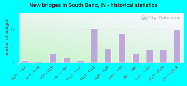
- New bridges - historical statistics
- 31900-1909
- 11910-1919
- 131920-1929
- 71930-1939
- 21940-1949
- 521950-1959
- 211960-1969
- 441970-1979
- 131980-1989
- 191990-1999
- 192000-2009
- 502010-2019
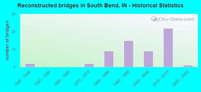
- Reconstructed bridges - Historical Statistics
- 21940-1949
- 01950-1959
- 01960-1969
- 21970-1979
- 91980-1989
- 151990-1999
- 92000-2009
- 222010-2019
- 12020-2022
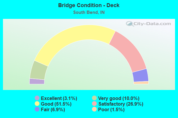
- Bridge Condition - Deck
- 3.1%Excellent
- 10.0%Very good
- 51.5%Good
- 26.9%Satisfactory
- 6.9%Fair
- 1.5%Poor
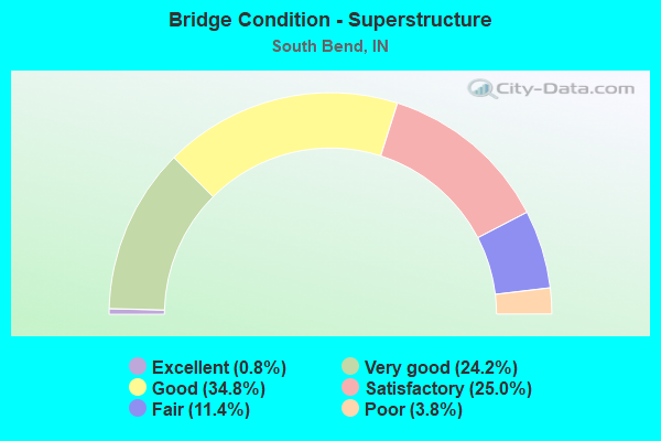
- Bridge Condition - Superstructure
- 0.8%Excellent
- 24.2%Very good
- 34.8%Good
- 25.0%Satisfactory
- 11.4%Fair
- 3.8%Poor
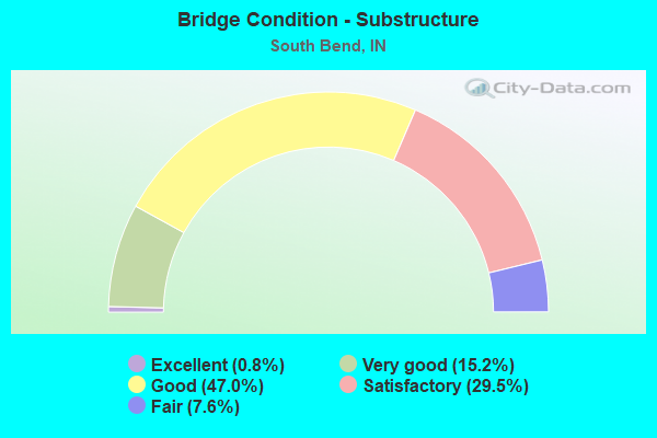
- Bridge Condition - Substructure
- 0.8%Excellent
- 15.2%Very good
- 47.0%Good
- 29.5%Satisfactory
- 7.6%Fair
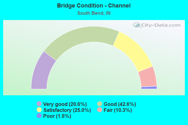
- Bridge Condition - Channel
- 20.6%Very good
- 42.6%Good
- 25.0%Satisfactory
- 10.3%Fair
- 1.5%Poor
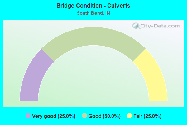
- Bridge Condition - Culverts
- 25.0%Very good
- 50.0%Good
- 25.0%Fair
Find on map >> Show street view
Structure Number: 7100058, Location: 01.20 E of MIAMI Hwy (Lat: 41.550111, Lng: -86.195811), Route carried "on" structure: Alternate County highway , Year Built: 1992, Status: Open, Structure Length: 0.85m (2.79ft), Average Daily Traffic: 207 (year 2018), Truck Traffic: 16%, Average Future Daily Traffic: 355 (year 2038), Design Load: HS 20, Features Intersected: KLINE Ditch, Facility Carried by Structure: OSBORNE Rd
Minimum Vertical Clearance: 30+ m (98+ ft), Kilometerpoint: 0.000, Lanes on structure: 2, Owner: County Highway Agency, Approaching Roadway Width: 6.7m (22.0ft), Skew: 2 degrees, Material/Design: Wood or Timber, Design/Construction: Slab, Number Of Spans In Main Unit: 1, Length of Maximum Span: 7.9m (25.9ft), Curb or Sidewalk Widths: Left: 0.2m (0.7ft), Right: 0.2m (0.7ft), Curb-To-Curb Width: 7.3m (24.0ft), Out-to-Out Width: 7.6m (24.9ft)
Condition: Deck: Good, Superstructure: Good, Substructure: Good, Channel: Good, Operating Rating: 50.3 metric tons, Method Used To Determine Operating Rating: Allowable Stress (AS), Inventory Rating: 35.9 metric tons, Method Used To Determine Inventory Rating: Allowable Stress (AS), Structural Evaluation: Better than present minimum criteria, Deck Geometry: Somewhat better than minimum adequacy, Waterway Adequacy: Better than present minimum criteria, Approach Roadway Alignment: Equal to present desirable criteria, Designated Inspection Frequency: Every 24 months, Inspection Date: September 2020, Deck Structure Type: Wood or Timber, Wearing Surface/Protective System: Wearing Surface: Bituminous
Find on map >> Show street view
Structure Number: 7100059, Location: 00.30 N of JACKSON Rd (Lat: 41.624969, Lng: -86.365561), Route carried "on" structure: County highway , Year Built: 1971, Status: Open, Structure Length: 2.13m (6.99ft), Average Daily Traffic: 410 (year 2018), Truck Traffic: 12%, Average Future Daily Traffic: 515 (year 2041), Design Load: HS 20, Features Intersected: PLACE Ditch, Facility Carried by Structure: PEACH Rd
Minimum Vertical Clearance: 30+ m (98+ ft), Kilometerpoint: 0.000, Lanes on structure: 2, Owner: County Highway Agency, Approaching Roadway Width: 7.0m (23.0ft), Skew: 3 degrees, Material/Design: Prestressed concrete, Design/Construction: Box Beam or Girders - Multiple, Number Of Spans In Main Unit: 1, Length of Maximum Span: 19.2m (63.0ft), Curb-To-Curb Width: 9.4m (30.8ft), Out-to-Out Width: 9.8m (32.2ft)
Condition: Deck: Poor, Superstructure: Poor, Substructure: Good, Channel: Good, Operating Rating: 50.9 metric tons, Method Used To Determine Operating Rating: Load Factor (LF), Inventory Rating: 31.8 metric tons, Method Used To Determine Inventory Rating: Load Factor (LF), Structural Evaluation: Meets minimum limits, Deck Geometry: Equal to present minimum criteria, Waterway Adequacy: Better than present minimum criteria, Approach Roadway Alignment: Equal to present desirable criteria, Length Of Structure Improvement: 2.13m (6.99ft), Designated Inspection Frequency: Every 12 months, Inspection Date: September 2021, Bridge Improvement Cost: $616,000, Roadway Improvement Cost: $62,000, Total Project Cost: $740,000 ( Estimate for 2020), Deck Structure Type: Concrete Cast-file-Place, Wearing Surface/Protective System: Wearing Surface: Monolithic Concrete
Find on map >> Show street view
Structure Number: 710007, Location: 01.20 W of IRONWOOD Rd (Lat: 41.507889, Lng: -86.236769), Route carried "on" structure: Alternate County highway , Year Built: 1993, Status: Open, Structure Length: 1.04m (3.41ft), Average Daily Traffic: 203 (year 2018), Truck Traffic: 19%, Average Future Daily Traffic: 248 (year 2038), Design Load: HS 20, Features Intersected: West Branch BUNCH Ditch, Facility Carried by Structure: RILEY Rd
Minimum Vertical Clearance: 30+ m (98+ ft), Kilometerpoint: 0.000, Lanes on structure: 2, Owner: County Highway Agency, Approaching Roadway Width: 6.7m (22.0ft), Material/Design: Wood or Timber, Design/Construction: Slab, Number Of Spans In Main Unit: 1, Length of Maximum Span: 9.4m (30.8ft), Curb-To-Curb Width: 7.4m (24.3ft), Out-to-Out Width: 7.9m (25.9ft)
Condition: Deck: Good, Superstructure: Good, Substructure: Good, Channel: Good, Operating Rating: 48.4 metric tons, Method Used To Determine Operating Rating: Allowable Stress (AS), Inventory Rating: 33.9 metric tons, Method Used To Determine Inventory Rating: Allowable Stress (AS), Structural Evaluation: Better than present minimum criteria, Deck Geometry: Somewhat better than minimum adequacy, Waterway Adequacy: Equal to present desirable criteria, Approach Roadway Alignment: Equal to present desirable criteria, Designated Inspection Frequency: Every 24 months, Inspection Date: September 2020, Deck Structure Type: Wood or Timber, Wearing Surface/Protective System: Wearing Surface: Bituminous
Find on map >> Show street view
Structure Number: 7100076, Location: 00.10 N of SR 933 (Lat: 41.665839, Lng: -86.236111), Route carried "on" structure: City street , Year Built: 1900, Year Reconstructed: 2002, Status: Open, Structure Length: 11.70m (38.39ft), Average Daily Traffic: 5,935 (year 2018), Truck Traffic: 2%, Average Future Daily Traffic: 7,241 (year 2038), Design Load: HS 20, Features Intersected: ST. JOSEPH River, Facility Carried by Structure: SAMPLE St
Minimum Vertical Clearance: 30+ m (98+ ft), Kilometerpoint: 0.000, Lanes on structure: 3, Owner: County Highway Agency, Approaching Roadway Width: 11.6m (38.1ft), Navigation Control: Yes ( Vertical Clearance: 4.6m (15.1ft), Horizontal Clearance: 21.9m (71.9ft)), Material/Design: Prestressed concrete continuous, Design/Construction: Stringer/Multi-beam, Number Of Spans In Main Unit: 5, Length of Maximum Span: 23.3m (76.4ft), Curb or Sidewalk Widths: Left: 0.0m, Right: 1.5m (4.9ft), Curb-To-Curb Width: 11.6m (38.1ft), Out-to-Out Width: 14.4m (47.2ft)
Condition: Deck: Satisfactory, Superstructure: Satisfactory, Substructure: Satisfactory, Channel: Very good, Operating Rating: 47.2 metric tons, Method Used To Determine Operating Rating: Load Factor (LF), Inventory Rating: 25.7 metric tons, Method Used To Determine Inventory Rating: Load Factor (LF), Structural Evaluation: Equal to present minimum criteria, Deck Geometry: High priority of replacement, Waterway Adequacy: Superior to present desirable criteria, Approach Roadway Alignment: Equal to present desirable criteria, Length Of Structure Improvement: 11.70m (38.39ft), Designated Inspection Frequency: Every 24 months, Underwater Inspection Frequency: Every 60 months, Inspection Date: September 2020, Underwater Inspection Date: August 2020, Bridge Improvement Cost: $653,000, Roadway Improvement Cost: $66,000, Total Project Cost: $980,000 ( Estimate for 2020), Deck Structure Type: Concrete Cast-file-Place, Wearing Surface/Protective System: Wearing Surface: Monolithic Concrete, Deck Protection: Epoxy Coated Reinforcing
Find on map >> Show street view
Structure Number: 710008, Location: 00.30 E of MIAMI Hwy (Lat: 41.493500, Lng: -86.187811), Route carried "on" structure: Alternate County highway , Year Built: 1935, Year Reconstructed: 1979, Status: Posted for load, Structure Length: 1.45m (4.76ft), Average Daily Traffic: 242 (year 2021), Truck Traffic: 15%, Average Future Daily Traffic: 295 (year 2041), Design Load: HS 20, Features Intersected: KLINE Ditch, Facility Carried by Structure: SHIVELY Rd
Minimum Vertical Clearance: 30+ m (98+ ft), Kilometerpoint: 0.000, Lanes on structure: 2, Owner: County Highway Agency, Approaching Roadway Width: 6.1m (20.0ft), Material/Design: Prestressed concrete, Design/Construction: Box Beam or Girders - Multiple, Number Of Spans In Main Unit: 1, Length of Maximum Span: 13.7m (44.9ft), Curb-To-Curb Width: 8.1m (26.6ft), Out-to-Out Width: 8.5m (27.9ft)
Condition: Deck: Poor, Superstructure: Poor, Substructure: Fair, Channel: Satisfactory, Operating Rating: 29.9 metric tons, Method Used To Determine Operating Rating: Load Factor (LF), Inventory Rating: 17.9 metric tons, Method Used To Determine Inventory Rating: Load Factor (LF), Structural Evaluation: Meets minimum limits, Deck Geometry: Somewhat better than minimum adequacy, Waterway Adequacy: Better than present minimum criteria, Approach Roadway Alignment: Equal to present desirable criteria, Bridge Posting: Required (Relationship of Operating Rating to Maximum Legal Load: 0.1 - 9.9% below), Length Of Structure Improvement: 2.13m (6.99ft), Designated Inspection Frequency: Every 12 months, Inspection Date: September 2021, Bridge Improvement Cost: $549,000, Roadway Improvement Cost: $55,000, Total Project Cost: $824,000 ( Estimate for 2020), Deck Structure Type: Concrete Precast Panels, Wearing Surface/Protective System: Wearing Surface: Bituminous
Find on map >> Show street view
Structure Number: 7100088, Location: 00.10 N SR 933 (Lat: 41.659731, Lng: -86.225519), Route carried "on" structure: City street , Year Built: 1929, Year Reconstructed: 2011, Status: Open, Structure Length: 13.24m (43.44ft), Average Daily Traffic: 7,350 (year 2019), Truck Traffic: 1%, Average Future Daily Traffic: 8,969 (year 2039), Design Load: HS 20, Features Intersected: ST JOSEPH RV/NSIDE BLVD, Facility Carried by Structure: TWYCKENHAM DR
Minimum Vertical Clearance: 30+ m (98+ ft), Kilometerpoint: 0.000, Lanes on structure: 3, Lanes under structure: 2, Owner: County Highway Agency, Approaching Roadway Width: 15.2m (49.9ft), Navigation Control: Yes ( Vertical Clearance: 9.1m (29.9ft), Horizontal Clearance: 30.5m (100.1ft)), Material/Design: Concrete, Design/Construction: Arch - Deck, Number Of Spans In Main Unit: 4, Length of Maximum Span: 35.1m (115.2ft), Curb or Sidewalk Widths: Left: 1.5m (4.9ft), Right: 1.5m (4.9ft), Curb-To-Curb Width: 15.2m (49.9ft), Out-to-Out Width: 19.2m (63.0ft)
Condition: Deck: Satisfactory, Superstructure: Good, Substructure: Satisfactory, Channel: Very good, Operating Rating: 32.7 metric tons, Method Used To Determine Operating Rating: Field evaluation and documented engineering judgment, Inventory Rating: 32.7 metric tons, Method Used To Determine Inventory Rating: Field evaluation and documented engineering judgment, Structural Evaluation: Equal to present minimum criteria, Deck Geometry: Equal to present minimum criteria, Underclear: Superior to present desirable criteria, Waterway Adequacy: Superior to present desirable criteria, Approach Roadway Alignment: Equal to present desirable criteria, Designated Inspection Frequency: Every 24 months, Underwater Inspection Frequency: Every 60 months, Other Special Inspection Frequency: Every 60 months, Inspection Date: September 2020, Underwater Inspection Date: August 2020, Other Special Inspection Date: June 2019, Deck Structure Type: Concrete Cast-file-Place, Wearing Surface/Protective System: Wearing Surface: Monolithic Concrete, Deck Protection: Epoxy Coated Reinforcing
Find on map >> Show street view
Structure Number: 71001, Location: 00.45 N FILLMORE ROAD (Lat: 41.686281, Lng: -86.322561), Route carried "on" structure: City street , Year Built: 1970, Year Reconstructed: 1999, Status: Open, Structure Length: 3.60m (11.81ft), Average Daily Traffic: 9,063 (year 2019), Truck Traffic: 16%, Average Future Daily Traffic: 12,386 (year 2041), Design Load: HS 20, Features Intersected: ARDMORE TRAIL, Facility Carried by Structure: MAYFLOWER ROAD
Minimum Vertical Clearance: 30+ m (98+ ft), Kilometerpoint: 0.000, Lanes on structure: 2, Lanes under structure: 2, Owner: County Highway Agency, Approaching Roadway Width: 13.1m (43.0ft), Skew: 1 degrees, Material/Design: Prestressed concrete, Design/Construction: Box Beam or Girders - Multiple, Number Of Spans In Main Unit: 3, Length of Maximum Span: 11.9m (39.0ft), Curb-To-Curb Width: 13.3m (43.6ft), Out-to-Out Width: 14.2m (46.6ft)
Condition: Deck: Satisfactory, Superstructure: Poor, Substructure: Satisfactory, Operating Rating: 78.8 metric tons, Method Used To Determine Operating Rating: Load Factor (LF), Inventory Rating: 39.3 metric tons, Method Used To Determine Inventory Rating: Load Factor (LF), Structural Evaluation: Meets minimum limits, Deck Geometry: Somewhat better than minimum adequacy, Underclear: High priority of corrective action, Approach Roadway Alignment: Equal to present desirable criteria, Length Of Structure Improvement: 3.60m (11.81ft), Designated Inspection Frequency: Every 12 months, Inspection Date: September 2021, Bridge Improvement Cost: $1,236,000, Roadway Improvement Cost: $124,000, Total Project Cost: $1,484,000 ( Estimate for 2020), Deck Structure Type: Concrete Cast-file-Place, Wearing Surface/Protective System: Wearing Surface: Monolithic Concrete
Find on map >> Show street view
Structure Number: 7100101, Location: 00.40 N OF FILLMORE ROAD (Lat: 41.685000, Lng: -86.322719), Route carried "on" structure: City street , Year Built: 1970, Year Reconstructed: 1995, Status: Open, Structure Length: 8.36m (27.43ft), Average Daily Traffic: 9,063 (year 2019), Truck Traffic: 16%, Average Future Daily Traffic: 12,386 (year 2041), Design Load: HS 20, Features Intersected: CONRAIL RR, Facility Carried by Structure: MAYFLOWER ROAD
Minimum Vertical Clearance: 30+ m (98+ ft), Kilometerpoint: 0.000, Lanes on structure: 2, Owner: County Highway Agency, Approaching Roadway Width: 13.1m (43.0ft), Skew: 1 degrees, Material/Design: Prestressed concrete, Design/Construction: Box Beam or Girders - Multiple, Number Of Spans In Main Unit: 7, Length of Maximum Span: 11.9m (39.0ft), Curb-To-Curb Width: 13.3m (43.6ft), Out-to-Out Width: 14.2m (46.6ft)
Condition: Deck: Satisfactory, Superstructure: Poor, Substructure: Satisfactory, Operating Rating: 50.8 metric tons, Method Used To Determine Operating Rating: Load Factor (LF), Inventory Rating: 29.9 metric tons, Method Used To Determine Inventory Rating: Load Factor (LF), Structural Evaluation: Meets minimum limits, Deck Geometry: Somewhat better than minimum adequacy, Underclear: Somewhat better than minimum adequacy, Approach Roadway Alignment: Equal to present desirable criteria, Length Of Structure Improvement: 8.35m (27.40ft), Designated Inspection Frequency: Every 12 months, Inspection Date: September 2021, Bridge Improvement Cost: $2,870,000, Roadway Improvement Cost: $287,000, Total Project Cost: $3,875,000 ( Estimate for 2020), Deck Structure Type: Concrete Cast-file-Place, Wearing Surface/Protective System: Wearing Surface: Monolithic Concrete
Find on map >> Show street view
Structure Number: 7100102, Location: 00.50 S of US 20 (Lat: 41.647111, Lng: -86.321831), Route carried "on" structure: County highway , Year Built: 1972, Status: Open, Structure Length: 2.49m (8.17ft), Average Daily Traffic: 6,056 (year 2019), Truck Traffic: 19%, Average Future Daily Traffic: 7,389 (year 2039), Design Load: HS 20, Features Intersected: PLACE Ditch, Facility Carried by Structure: MAYFLOWER Rd
Minimum Vertical Clearance: 30+ m (98+ ft), Kilometerpoint: 0.000, Lanes on structure: 2, Owner: County Highway Agency, Approaching Roadway Width: 13.4m (44.0ft), Skew: 1 degrees, Material/Design: Concrete continuous, Design/Construction: Slab, Number Of Spans In Main Unit: 3, Length of Maximum Span: 9.4m (30.8ft), Curb-To-Curb Width: 13.4m (44.0ft), Out-to-Out Width: 14.2m (46.6ft)
Condition: Deck: Fair, Superstructure: Fair, Substructure: Satisfactory, Channel: Satisfactory, Operating Rating: 51.0 metric tons, Method Used To Determine Operating Rating: Load Factor (LF), Inventory Rating: 30.5 metric tons, Method Used To Determine Inventory Rating: Load Factor (LF), Structural Evaluation: Somewhat better than minimum adequacy, Deck Geometry: Equal to present minimum criteria, Waterway Adequacy: Equal to present desirable criteria, Approach Roadway Alignment: Equal to present desirable criteria, Length Of Structure Improvement: 2.50m (8.20ft), Designated Inspection Frequency: Every 24 months, Inspection Date: September 2020, Bridge Improvement Cost: $399,000, Roadway Improvement Cost: $72,000, Total Project Cost: $671,000 ( Estimate for 2020), Deck Structure Type: Concrete Cast-file-Place, Wearing Surface/Protective System: Wearing Surface: Bituminous, Membrane: Preformed Fabric
Find on map >> Show street view
Structure Number: 7100106, Location: 00.20 E SR 933 (Lat: 41.679139, Lng: -86.245500), Route carried "on" structure: City street , Year Built: 1993, Status: Open, Structure Length: 1.88m (6.17ft), Average Daily Traffic: 16,211 (year 2018), Truck Traffic: 2%, Average Future Daily Traffic: 19,780 (year 2038), Design Load: HS 20, Features Intersected: EAST RACE WAY, Facility Carried by Structure: LASALLE STREET
Minimum Vertical Clearance: 30+ m (98+ ft), Kilometerpoint: 0.000, Lanes on structure: 4, Owner: County Highway Agency, Approaching Roadway Width: 15.5m (50.9ft), Skew: 1 degrees, Material/Design: Prestressed concrete, Design/Construction: Box Beam or Girders - Single/Spread, Number Of Spans In Main Unit: 1, Length of Maximum Span: 18.0m (59.1ft), Curb or Sidewalk Widths: Left: 4.0m (13.1ft), Right: 4.0m (13.1ft), Curb-To-Curb Width: 15.5m (50.9ft), Out-to-Out Width: 24.4m (80.1ft)
Condition: Deck: Fair, Superstructure: Fair, Substructure: Good, Channel: Very good, Inventory Rating: 28.9 metric tons, Method Used To Determine Inventory Rating: Load Factor (LF), Structural Evaluation: Somewhat better than minimum adequacy, Deck Geometry: Meets minimum limits, Waterway Adequacy: Equal to present desirable criteria, Approach Roadway Alignment: Equal to present desirable criteria, Length Of Structure Improvement: 1.89m (6.20ft), Designated Inspection Frequency: Every 24 months, Inspection Date: September 2020, Bridge Improvement Cost: $350,000, Roadway Improvement Cost: $35,000, Total Project Cost: $525,000 ( Estimate for 2020), Deck Structure Type: Concrete Cast-file-Place, Wearing Surface/Protective System: Wearing Surface: Monolithic Concrete
Find on map >> Show street view
Structure Number: 7100108, Location: 00.10 N of SAMPLE St (Lat: 41.665081, Lng: -86.282839), Route carried "on" structure: City street , Year Built: 1984, Year Reconstructed: 2017, Status: Open, Structure Length: 7.99m (26.21ft), Average Daily Traffic: 9,847 (year 2017), Truck Traffic: 13%, Average Future Daily Traffic: 12,015 (year 2037), Design Load: HS 20, Features Intersected: CONRAIL AND GTW RR, Facility Carried by Structure: OLIVE St
Minimum Vertical Clearance: 30+ m (98+ ft), Kilometerpoint: 0.000, Lanes on structure: 2, Owner: County Highway Agency, Approaching Roadway Width: 13.5m (44.3ft), Skew: 1 degrees, Material/Design: Prestressed concrete continuous, Design/Construction: Stringer/Multi-beam, Number Of Spans In Main Unit: 4, Length of Maximum Span: 24.7m (81.0ft), Curb or Sidewalk Widths: Left: 7.2m (23.6ft), Right: 2.5m (8.2ft), Curb-To-Curb Width: 13.5m (44.3ft), Out-to-Out Width: 23.9m (78.4ft)
Condition: Deck: Good, Superstructure: Fair, Substructure: Good, Operating Rating: 55.3 metric tons, Method Used To Determine Operating Rating: Load Factor (LF), Inventory Rating: 30.9 metric tons, Method Used To Determine Inventory Rating: Load Factor (LF), Structural Evaluation: Somewhat better than minimum adequacy, Deck Geometry: Superior to present desirable criteria, Underclear: Equal to present minimum criteria, Approach Roadway Alignment: Equal to present desirable criteria, Length Of Structure Improvement: 7.99m (26.21ft), Designated Inspection Frequency: Every 24 months, Inspection Date: September 2020, Bridge Improvement Cost: $25,000, Roadway Improvement Cost: $3,000, Total Project Cost: $38,000 ( Estimate for 2020), Deck Structure Type: Concrete Cast-file-Place, Wearing Surface/Protective System: Wearing Surface: Monolithic Concrete, Deck Protection: Epoxy Coated Reinforcing
Find on map >> Show street view
Structure Number: 7100109, Location: 00.10 W of OLIVE St (Lat: 41.664611, Lng: -86.284469), Route carried "on" structure: City street , Year Built: 1984, Year Reconstructed: 2017, Status: Open, Structure Length: 12.33m (40.45ft), Average Daily Traffic: 14,005 (year 2020), Truck Traffic: 3%, Average Future Daily Traffic: 14,200 (year 2040), Design Load: HS 20, Features Intersected: CONRAIL AND GTW RR, Facility Carried by Structure: SAMPLE St
Minimum Vertical Clearance: 30+ m (98+ ft), Kilometerpoint: 0.000, Lanes on structure: 4, Owner: County Highway Agency, Approaching Roadway Width: 18.1m (59.4ft), Skew: 5 degrees, Material/Design: Prestressed concrete continuous, Design/Construction: Stringer/Multi-beam, Number Of Spans In Main Unit: 5, Length of Maximum Span: 28.3m (92.8ft), Curb or Sidewalk Widths: Left: 2.5m (8.2ft), Right: 2.5m (8.2ft), Curb-To-Curb Width: 18.1m (59.4ft), Out-to-Out Width: 23.9m (78.4ft)
Condition: Deck: Good, Superstructure: Fair, Substructure: Satisfactory, Operating Rating: 64.1 metric tons, Method Used To Determine Operating Rating: Load Factor (LF), Inventory Rating: 33.0 metric tons, Method Used To Determine Inventory Rating: Load Factor (LF), Structural Evaluation: Somewhat better than minimum adequacy, Deck Geometry: Somewhat better than minimum adequacy, Underclear: Equal to present minimum criteria, Approach Roadway Alignment: Equal to present desirable criteria, Length Of Structure Improvement: 12.31m (40.39ft), Designated Inspection Frequency: Every 24 months, Inspection Date: September 2020, Bridge Improvement Cost: $45,000, Roadway Improvement Cost: $5,000, Total Project Cost: $68,000 ( Estimate for 2020), Deck Structure Type: Concrete Cast-file-Place, Wearing Surface/Protective System: Wearing Surface: Monolithic Concrete, Deck Protection: Epoxy Coated Reinforcing
Find on map >> Show street view
Structure Number: 7100111, Location: 00.10 N of SHIVELY Rd (Lat: 41.495281, Lng: -86.253081), Route carried "on" structure: County highway , Year Built: 1988, Status: Open, Structure Length: 0.98m (3.22ft), Average Daily Traffic: 128 (year 2018), Truck Traffic: 7%, Average Future Daily Traffic: 156 (year 2038), Design Load: HS 20, Features Intersected: HESTON Creek, Facility Carried by Structure: KENILWORTH Rd
Minimum Vertical Clearance: 30+ m (98+ ft), Kilometerpoint: 0.000, Lanes on structure: 2, Owner: County Highway Agency, Approaching Roadway Width: 5.8m (19.0ft), Skew: 4 degrees, Material/Design: Wood or Timber, Design/Construction: Slab, Number Of Spans In Main Unit: 1, Length of Maximum Span: 8.8m (28.9ft), Curb or Sidewalk Widths: Left: 0.2m (0.7ft), Right: 0.2m (0.7ft), Curb-To-Curb Width: 7.3m (24.0ft), Out-to-Out Width: 7.7m (25.3ft)
Condition: Deck: Satisfactory, Superstructure: Satisfactory, Substructure: Good, Channel: Good, Operating Rating: 51.6 metric tons, Method Used To Determine Operating Rating: Allowable Stress (AS), Inventory Rating: 35.5 metric tons, Method Used To Determine Inventory Rating: Allowable Stress (AS), Structural Evaluation: Equal to present minimum criteria, Deck Geometry: Somewhat better than minimum adequacy, Waterway Adequacy: Better than present minimum criteria, Approach Roadway Alignment: Equal to present desirable criteria, Length Of Structure Improvement: 0.98m (3.22ft), Designated Inspection Frequency: Every 24 months, Inspection Date: September 2020, Bridge Improvement Cost: $34,000, Roadway Improvement Cost: $10,000, Total Project Cost: $61,000 ( Estimate for 2020), Deck Structure Type: Wood or Timber, Wearing Surface/Protective System: Wearing Surface: Bituminous
Find on map >> Show street view
Structure Number: 7100117, Location: 00.20 E SR 933 (Lat: 41.677781, Lng: -86.245161), Route carried "on" structure: City street , Year Built: 1998, Status: Open, Structure Length: 2.63m (8.63ft), Average Daily Traffic: 9,178 (year 2018), Truck Traffic: 2%, Average Future Daily Traffic: 11,200 (year 2038), Design Load: HS 20, Features Intersected: EAST RACE WAY, Facility Carried by Structure: COLFAX
Minimum Vertical Clearance: 30+ m (98+ ft), Kilometerpoint: 0.000, Lanes on structure: 3, Owner: County Highway Agency, Approaching Roadway Width: 15.5m (50.9ft), Material/Design: Prestressed concrete, Design/Construction: Box Beam or Girders - Multiple, Number Of Spans In Main Unit: 1, Length of Maximum Span: 25.5m (83.7ft), Curb or Sidewalk Widths: Left: 2.7m (8.9ft), Right: 2.7m (8.9ft), Curb-To-Curb Width: 15.5m (50.9ft), Out-to-Out Width: 21.9m (71.9ft)
Condition: Deck: Good, Superstructure: Good, Substructure: Very good, Channel: Very good, Operating Rating: 86.2 metric tons, Method Used To Determine Operating Rating: Load Factor (LF), Inventory Rating: 36.8 metric tons, Method Used To Determine Inventory Rating: Load Factor (LF), Structural Evaluation: Better than present minimum criteria, Deck Geometry: Equal to present minimum criteria, Waterway Adequacy: Equal to present desirable criteria, Approach Roadway Alignment: Equal to present desirable criteria, Designated Inspection Frequency: Every 24 months, Inspection Date: September 2020, Deck Structure Type: Concrete Cast-file-Place, Wearing Surface/Protective System: Wearing Surface: Monolithic Concrete, Deck Protection: Epoxy Coated Reinforcing
Find on map >> Show street view
Structure Number: 7100118, Location: 00.04 E SR 933 (Lat: 41.677781, Lng: -86.248050), Route carried "on" structure: City street , Year Built: 1983, Year Reconstructed: 1995, Status: Open, Structure Length: 11.86m (38.91ft), Average Daily Traffic: 9,178 (year 2018), Truck Traffic: 2%, Average Future Daily Traffic: 11,200 (year 2038), Design Load: HS 20, Features Intersected: ST JOSEPH RIVER, Facility Carried by Structure: COLFAX
Minimum Vertical Clearance: 30+ m (98+ ft), Kilometerpoint: 0.000, Lanes on structure: 3, Owner: County Highway Agency, Approaching Roadway Width: 15.9m (52.2ft), Skew: 4 degrees, Navigation Control: Yes ( Vertical Clearance: 4.6m (15.1ft), Horizontal Clearance: 25.9m (85.0ft)), Material/Design: Prestressed concrete continuous, Design/Construction: Stringer/Multi-beam, Number Of Spans In Main Unit: 4, Number Of Approach Spans: 1, Length of Maximum Span: 27.5m (90.2ft), Curb or Sidewalk Widths: Left: 1.8m (5.9ft), Right: 1.8m (5.9ft), Curb-To-Curb Width: 15.9m (52.2ft), Out-to-Out Width: 19.8m (65.0ft)
Condition: Deck: Satisfactory, Superstructure: Good, Substructure: Fair, Channel: Good, Operating Rating: 54.5 metric tons, Method Used To Determine Operating Rating: Load Factor (LF), Inventory Rating: 30.8 metric tons, Method Used To Determine Inventory Rating: Load Factor (LF), Structural Evaluation: Somewhat better than minimum adequacy, Deck Geometry: Better than present minimum criteria, Waterway Adequacy: Superior to present desirable criteria, Approach Roadway Alignment: Equal to present desirable criteria, Length Of Structure Improvement: 11.86m (38.91ft), Designated Inspection Frequency: Every 24 months, Underwater Inspection Frequency: Every 60 months, Inspection Date: September 2020, Underwater Inspection Date: August 2020, Bridge Improvement Cost: $527,000, Roadway Improvement Cost: $53,000, Total Project Cost: $791,000 ( Estimate for 2020), Deck Structure Type: Concrete Cast-file-Place, Wearing Surface/Protective System: Wearing Surface: Monolithic Concrete, Deck Protection: Epoxy Coated Reinforcing
Find on map >> Show street view
Structure Number: 7100133, Location: 00.20 S OF EWING AVENUE (Lat: 41.648450, Lng: -86.251300), Route carried "on" structure: City street , Year Built: 1920, Year Reconstructed: 1940, Status: Open, Structure Length: 0.73m (2.40ft), Average Daily Traffic: 11,873 (year 2019), Truck Traffic: 4%, Average Future Daily Traffic: 14,488 (year 2039), Design Load: HS 20, Features Intersected: BOWMAN CREEK, Facility Carried by Structure: SOUTH MAIN STREET
Minimum Vertical Clearance: 30+ m (98+ ft), Kilometerpoint: 0.000, Lanes on structure: 3, Owner: County Highway Agency, Approaching Roadway Width: 13.1m (43.0ft), Skew: 4 degrees, Material/Design: Concrete, Design/Construction: Slab, Number Of Spans In Main Unit: 1, Length of Maximum Span: 6.5m (21.3ft), Curb or Sidewalk Widths: Left: 8.2m (26.9ft), Right: 7.9m (25.9ft), Curb-To-Curb Width: 13.1m (43.0ft), Out-to-Out Width: 30.3m (99.4ft)
Condition: Deck: Satisfactory, Superstructure: Satisfactory, Substructure: Fair, Channel: Satisfactory, Operating Rating: 32.7 metric tons, Method Used To Determine Operating Rating: Field evaluation and documented engineering judgment, Inventory Rating: 32.7 metric tons, Method Used To Determine Inventory Rating: Field evaluation and documented engineering judgment, Structural Evaluation: Somewhat better than minimum adequacy, Deck Geometry: Meets minimum limits, Waterway Adequacy: Superior to present desirable criteria, Approach Roadway Alignment: Equal to present desirable criteria, Length Of Structure Improvement: 0.43m (1.41ft), Designated Inspection Frequency: Every 24 months, Inspection Date: September 2020, Bridge Improvement Cost: $383,000, Roadway Improvement Cost: $39,000, Total Project Cost: $575,000 ( Estimate for 2020), Deck Structure Type: Concrete Cast-file-Place, Wearing Surface/Protective System: Wearing Surface: Bituminous
Find on map >> Show street view
Structure Number: 7100134, Location: 00.10 N EWING AVENUE (Lat: 41.652050, Lng: -86.246061), Route carried "on" structure: City street , Year Built: 1920, Status: Open, Structure Length: 0.76m (2.49ft), Average Daily Traffic: 300 (year 2014), Truck Traffic: 1%, Average Future Daily Traffic: 370 (year 2034), Features Intersected: BOWMAN CREEK, Facility Carried by Structure: CARROLL STREET
Minimum Vertical Clearance: 30+ m (98+ ft), Kilometerpoint: 0.000, Lanes on structure: 2, Owner: County Highway Agency, Approaching Roadway Width: 7.9m (25.9ft), Skew: 1 degrees, Material/Design: Steel, Design/Construction: Stringer/Multi-beam, Number Of Spans In Main Unit: 1, Length of Maximum Span: 7.0m (23.0ft), Curb or Sidewalk Widths: Left: 2.4m (7.9ft), Right: 2.7m (8.9ft), Curb-To-Curb Width: 7.9m (25.9ft), Out-to-Out Width: 13.7m (44.9ft)
Condition: Deck: Fair, Superstructure: Satisfactory, Substructure: Fair, Channel: Poor, Operating Rating: 59.2 metric tons, Method Used To Determine Operating Rating: Load Factor (LF), Inventory Rating: 32.5 metric tons, Method Used To Determine Inventory Rating: Load Factor (LF), Structural Evaluation: Somewhat better than minimum adequacy, Deck Geometry: Somewhat better than minimum adequacy, Waterway Adequacy: Meets minimum limits, Approach Roadway Alignment: Equal to present desirable criteria, Length Of Structure Improvement: 0.58m (1.90ft), Designated Inspection Frequency: Every 24 months, Inspection Date: September 2020, Bridge Improvement Cost: $236,000, Roadway Improvement Cost: $24,000, Total Project Cost: $354,000 ( Estimate for 2020), Deck Structure Type: Concrete Cast-file-Place, Wearing Surface/Protective System: Wearing Surface: Bituminous
Find on map >> Show street view
Structure Number: 7100135, Location: 00.10 E JUNIPER ROAD (Lat: 41.717861, Lng: -86.234569), Route carried "on" structure: City street , Year Built: 1998, Status: Open, Structure Length: 0.94m (3.08ft), Average Daily Traffic: 386 (year 2017), Truck Traffic: 2%, Average Future Daily Traffic: 470 (year 2037), Design Load: H 20, Features Intersected: JUDAY CREEK, Facility Carried by Structure: KINTZ ROAD
Minimum Vertical Clearance: 30+ m (98+ ft), Kilometerpoint: 0.000, Lanes on structure: 2, Owner: County Highway Agency, Approaching Roadway Width: 5.2m (17.1ft), Skew: 5 degrees, Material/Design: Steel, Design/Construction: Culvert, Number Of Spans In Main Unit: 1, Length of Maximum Span: 9.0m (29.5ft)
Condition: Channel: Good, Culverts: Good, Operating Rating: 53.5 metric tons, Method Used To Determine Operating Rating: Load and Resistance Factor (LRFR), Inventory Rating: 32.0 metric tons, Method Used To Determine Inventory Rating: Load and Resistance Factor (LRFR), Structural Evaluation: Better than present minimum criteria, Waterway Adequacy: Equal to present desirable criteria, Approach Roadway Alignment: Equal to present desirable criteria, Designated Inspection Frequency: Every 24 months, Inspection Date: September 2020
Find on map >> Show street view
Structure Number: 7100136, Location: 00.10 N. OF CLEVELAND ROA (Lat: 41.724089, Lng: -86.255419), Route carried "on" structure: Alternate City street , Year Built: 2010, Status: Open, Structure Length: 0.67m (2.20ft), Average Daily Traffic: 507 (year 2018), Truck Traffic: 2%, Average Future Daily Traffic: 618 (year 2038), Design Load: HS 25 or greater, Features Intersected: JUDAY CREEK, Facility Carried by Structure: KENILWORTH ROAD
Minimum Vertical Clearance: 30+ m (98+ ft), Kilometerpoint: 0.000, Lanes on structure: 2, Owner: County Highway Agency, Approaching Roadway Width: 9.1m (29.9ft), Skew: 1 degrees, Material/Design: Concrete, Design/Construction: Culvert, Number Of Spans In Main Unit: 1, Length of Maximum Span: 6.2m (20.3ft)
Condition: Channel: Good, Culverts: Very good, Operating Rating: 32.7 metric tons, Method Used To Determine Operating Rating: Field evaluation and documented engineering judgment, Inventory Rating: 32.7 metric tons, Method Used To Determine Inventory Rating: Field evaluation and documented engineering judgment, Structural Evaluation: Equal to present desirable criteria, Waterway Adequacy: Better than present minimum criteria, Approach Roadway Alignment: Equal to present desirable criteria, Designated Inspection Frequency: Every 24 months, Inspection Date: September 2020
Find on map >> Show street view
Structure Number: 7100144, Location: 00.80 E SR 23 (Lat: 41.476469, Lng: -86.464739), Route carried "on" structure: Alternate County highway , Year Built: 2012, Status: Open, Structure Length: 2.33m (7.64ft), Average Daily Traffic: 234 (year 2014), Truck Traffic: 10%, Average Future Daily Traffic: 286 (year 2034), Design Load: HL 93, Features Intersected: YELLOW BANK CREEK, Facility Carried by Structure: TYLER ROAD
Minimum Vertical Clearance: 30+ m (98+ ft), Kilometerpoint: 0.000, Lanes on structure: 2, Owner: County Highway Agency, Approaching Roadway Width: 8.5m (27.9ft), Skew: 3 degrees, Material/Design: Concrete continuous, Design/Construction: Slab, Number Of Spans In Main Unit: 3, Length of Maximum Span: 9.1m (29.9ft), Curb-To-Curb Width: 8.5m (27.9ft), Out-to-Out Width: 8.7m (28.5ft)
Condition: Deck: Good, Superstructure: Good, Substructure: Good, Channel: Satisfactory, Operating Rating: 51.0 metric tons, Method Used To Determine Operating Rating: Load and Resistance Factor (LRFR), Inventory Rating: 42.2 metric tons, Method Used To Determine Inventory Rating: Load and Resistance Factor (LRFR), Structural Evaluation: Better than present minimum criteria, Deck Geometry: Equal to present minimum criteria, Waterway Adequacy: Superior to present desirable criteria, Approach Roadway Alignment: Equal to present desirable criteria, Designated Inspection Frequency: Every 24 months, Inspection Date: September 2020, Deck Structure Type: Concrete Cast-file-Place, Wearing Surface/Protective System: Wearing Surface: Integral Concrete, Deck Protection: Epoxy Coated Reinforcing
Find on map >> Show street view
Structure Number: 7100146, Location: 00.50 SW US 20 (Lat: 41.616869, Lng: -86.253919), Route carried "on" structure: City street , Year Built: 2016, Status: Open, Structure Length: 2.03m (6.66ft), Average Daily Traffic: 4,260 (year 2012), Truck Traffic: 2%, Average Future Daily Traffic: 5,200 (year 2032), Design Load: HL 93, Features Intersected: MAIN ST, Facility Carried by Structure: JOHNSON RD
Minimum Vertical Clearance: 30+ m (98+ ft), Kilometerpoint: 41.344, Lanes on structure: 2, Lanes under structure: 2, Owner: City or Municipal Highway Agency, Approaching Roadway Width: 8.5m (27.9ft), Material/Design: Prestressed concrete, Design/Construction: Tee Beam, Number Of Spans In Main Unit: 1, Length of Maximum Span: 19.9m (65.3ft), Curb or Sidewalk Widths: Left: 2.0m (6.6ft), Right: 2.0m (6.6ft), Curb-To-Curb Width: 8.5m (27.9ft), Out-to-Out Width: 13.3m (43.6ft)
Condition: Deck: Good, Superstructure: Very good, Substructure: Very good, Operating Rating: 62.2 metric tons, Method Used To Determine Operating Rating: Load and Resistance Factor (LRFR), Inventory Rating: 39.7 metric tons, Method Used To Determine Inventory Rating: Load and Resistance Factor (LRFR), Structural Evaluation: Equal to present desirable criteria, Deck Geometry: Meets minimum limits, Underclear: Equal to present minimum criteria, Approach Roadway Alignment: Equal to present desirable criteria, Designated Inspection Frequency: Every 24 months, Inspection Date: September 2020, Deck Structure Type: Concrete Cast-file-Place, Wearing Surface/Protective System: Wearing Surface: Monolithic Concrete, Deck Protection: Epoxy Coated Reinforcing
Find on map >> Show street view
Structure Number: 5502, Location: 01.38 E US-31 (Lat: 41.626411, Lng: -86.225089), Route carried "under" structure: City street , Year Built: 1988, Structure Length: 0. m, Average Daily Traffic: 4,585 (year 2004), Truck Traffic: 5%, Features Intersected: YORK ROAD, Facility Carried by Structure: US 20
Minimum Vertical Clearance: 4.27m (14.01ft), Kilometerpoint: 0.000, Lanes on structure: 4, Lanes under structure: 2, Material/Design: Prestressed concrete continuous, Design/Construction: Stringer/Multi-beam, Length of Maximum Span: 19.7m (64.6ft)
Find on map >> Show street view
Structure Number: 5503, Location: 01.88 E US-31 (Lat: 41.626800, Lng: -86.215539), Route carried "under" structure: City street , Year Built: 1988, Structure Length: 0. m, Average Daily Traffic: 21,647 (year 2018), Truck Traffic: 12%, Features Intersected: IRONWOOD RD. (& RAMPS), Facility Carried by Structure: US 20
Minimum Vertical Clearance: 5.11m (16.77ft), Kilometerpoint: 0.000, Lanes on structure: 4, Lanes under structure: 5, Material/Design: Steel continuous, Design/Construction: Stringer/Multi-beam, Length of Maximum Span: 59.1m (193.9ft)
Find on map >> Show street view
Structure Number: 582, Location: 00.88 S US 20X (Lat: 41.666681, Lng: -86.238511), Route carried "under" structure: City street , Year Built: 1962, Structure Length: 0. m, Average Daily Traffic: 8,052 (year 2018), Truck Traffic: 3%, Features Intersected: LINCOLNWAY SB, Facility Carried by Structure: SR 23/SR 933 NB
Minimum Vertical Clearance: 4.40m (14.44ft), Kilometerpoint: 15.305, Lanes on structure: 8, Lanes under structure: 5, Material/Design: Steel, Design/Construction: Stringer/Multi-beam, Length of Maximum Span: 24.7m (81.0ft)
Find on map >> Show street view
Structure Number: 582, Location: 00.88 S US 20X (Lat: 41.666681, Lng: -86.238517), Route carried "under" structure: State highway 933, Year Built: 1962, Structure Length: 0. m, Average Daily Traffic: 10,825 (year 2018), Truck Traffic: 3%, Features Intersected: SR 933 NB / LINCOLNWAY
Minimum Vertical Clearance: 4.40m (14.44ft), Kilometerpoint: 15.305, Lanes on structure: 8, Lanes under structure: 5, Material/Design: Steel, Design/Construction: Stringer/Multi-beam, Length of Maximum Span: 24.7m (81.0ft)
Find on map >> Show street view
Structure Number: 583, Location: 00.09 N SR 933 (Lat: 41.667389, Lng: -86.237100), Route carried "under" structure: City street , Year Built: 1962, Structure Length: 0. m, Average Daily Traffic: 4,244 (year 2018), Truck Traffic: 5%, Features Intersected: NORTHSIDE BLVD, Facility Carried by Structure: SR 23
Minimum Vertical Clearance: 4.85m (15.91ft), Kilometerpoint: 0.000, Lanes on structure: 6, Lanes under structure: 2, Material/Design: Steel continuous, Design/Construction: Stringer/Multi-beam, Length of Maximum Span: 45.0m (147.6ft)
Find on map >> Show street view
Structure Number: 584, Location: 00.19 N SR-933 (Lat: 41.668139, Lng: -86.235639), Route carried "under" structure: City street , Year Built: 1962, Structure Length: 0. m, Average Daily Traffic: 1,971 (year 2018), Truck Traffic: 12%, Features Intersected: MISHAWAKA AVENUE WB, Facility Carried by Structure: SR 23
Minimum Vertical Clearance: 4.67m (15.32ft), Kilometerpoint: 0.000, Lanes on structure: 6, Lanes under structure: 4, Material/Design: Prestressed concrete continuous, Design/Construction: Stringer/Multi-beam, Length of Maximum Span: 20.3m (66.6ft)
Find on map >> Show street view
Structure Number: 584, Location: 00.19 N SR-933 (Lat: 41.668139, Lng: -86.235642), Route carried "under" structure: City street , Year Built: 1962, Structure Length: 0. m, Average Daily Traffic: 2,273 (year 2018), Truck Traffic: 12%, Features Intersected: MISHAWAKA AVENUE EB, Facility Carried by Structure: SR 23
Minimum Vertical Clearance: 4.57m (14.99ft), Kilometerpoint: 0.000, Lanes on structure: 6, Lanes under structure: 4, Material/Design: Prestressed concrete continuous, Design/Construction: Stringer/Multi-beam, Length of Maximum Span: 20.3m (66.6ft)
Find on map >> Show street view
Structure Number: 1017, Location: 02.75 E SR-23 (Lat: 41.624450, Lng: -86.251517), Route carried "under" structure: US 31, Year Built: 1966, Structure Length: 0. m, Average Daily Traffic: 10,074 (year 2020), Truck Traffic: 6%, Features Intersected: US-31 NBL, Facility Carried by Structure: US 20
Minimum Vertical Clearance: 4.42m (14.50ft), Kilometerpoint: 17.284, Lanes on structure: 6, Lanes under structure: 6, Material/Design: Steel continuous, Design/Construction: Stringer/Multi-beam, Length of Maximum Span: 27.6m (90.6ft)
Find on map >> Show street view
Structure Number: 1017, Location: 02.75 E SR-23 (Lat: 41.624450, Lng: -86.251517), Route carried "under" structure: US 31, Year Built: 1966, Structure Length: 0. m, Average Daily Traffic: 9,329 (year 2020), Truck Traffic: 6%, Features Intersected: US-31 SBL, Facility Carried by Structure: US 20
Minimum Vertical Clearance: 4.42m (14.50ft), Kilometerpoint: 17.284, Lanes on structure: 6, Lanes under structure: 6, Material/Design: Steel continuous, Design/Construction: Stringer/Multi-beam, Length of Maximum Span: 27.6m (90.6ft)
Find on map >> Show street view
Structure Number: 10176, Location: 01.67 E SR-23 (Lat: 41.626039, Lng: -86.272742), Route carried "under" structure: US 20, Year Built: 1997, Structure Length: 0. m, Average Daily Traffic: 11,399 (year 2004), Truck Traffic: 10%, Features Intersected: US-20 (US-31) EBL, Facility Carried by Structure: LINDEN ROAD
Minimum Vertical Clearance: 5.01m (16.44ft), Kilometerpoint: 27.681, Lanes on structure: 2, Lanes under structure: 4, Material/Design: Steel continuous, Design/Construction: Stringer/Multi-beam, Length of Maximum Span: 32.0m (105.0ft)
Find on map >> Show street view
Structure Number: 10176, Location: 01.67 E SR-23 (Lat: 41.626039, Lng: -86.272742), Route carried "under" structure: US 20, Year Built: 1997, Structure Length: 0. m, Average Daily Traffic: 11,399 (year 2004), Truck Traffic: 10%, Features Intersected: US-20 (US-31) WBL, Facility Carried by Structure: LINDEN ROAD
Minimum Vertical Clearance: 5.01m (16.44ft), Kilometerpoint: 27.681, Lanes on structure: 2, Lanes under structure: 4, Material/Design: Steel continuous, Design/Construction: Stringer/Multi-beam, Length of Maximum Span: 32.0m (105.0ft)
Find on map >> Show street view
Structure Number: 10188, Location: 01.10 W SR 23 (Lat: 41.650289, Lng: -86.315261), Route carried "under" structure: ServiceOther road , Year Built: 1964, Structure Length: 0. m, Average Daily Traffic: 118 (year 2004), Truck Traffic: 20%, Features Intersected: US 20/31 EB/WB, Facility Carried by Structure: FRONTAGE RD
Minimum Vertical Clearance: 8.31m (27.26ft), Kilometerpoint: 0.000, Lanes on structure: 4, Lanes under structure: 2, Material/Design: Steel continuous, Design/Construction: Stringer/Multi-beam, Length of Maximum Span: 18.3m (60.0ft)
Find on map >> Show street view
Structure Number: 10191, Location: 01.40 W SR-23 (Lat: 41.652611, Lng: -86.319978), Route carried "under" structure: ServiceCity street , Year Built: 1961, Structure Length: 0. m, Average Daily Traffic: 118 (year 2004), Truck Traffic: 5%, Features Intersected: FARM ROAD, Facility Carried by Structure: US 20/31 EB/WB
Minimum Vertical Clearance: 5.74m (18.83ft), Kilometerpoint: 0.000, Lanes on structure: 6, Lanes under structure: 2, Material/Design: Steel continuous, Design/Construction: Stringer/Multi-beam, Length of Maximum Span: 21.9m (71.9ft)
Find on map >> Show street view
Structure Number: 10194, Location: 01.52 W SR-23 (Lat: 41.653681, Lng: -86.322014), Route carried "under" structure: County highway , Year Built: 1961, Structure Length: 0. m, Average Daily Traffic: 4,467 (year 2020), Truck Traffic: 9%, Features Intersected: MAYFLOWER ROAD SBL, Facility Carried by Structure: US 20/31 EB/WB
Minimum Vertical Clearance: 4.57m (14.99ft), Kilometerpoint: 0.000, Lanes on structure: 5, Lanes under structure: 4, Material/Design: Steel continuous, Design/Construction: Stringer/Multi-beam, Length of Maximum Span: 17.7m (58.1ft)
Find on map >> Show street view
Structure Number: 10194, Location: 01.52 W SR-23 (Lat: 41.653681, Lng: -86.322014), Route carried "under" structure: City street , Year Built: 1961, Structure Length: 0. m, Average Daily Traffic: 1,974 (year 2020), Truck Traffic: 9%, Features Intersected: MAYFLOWER ROAD NBL, Facility Carried by Structure: US 20/31 EB/WB
Minimum Vertical Clearance: 4.57m (14.99ft), Kilometerpoint: 0.000, Lanes on structure: 5, Lanes under structure: 4, Material/Design: Steel continuous, Design/Construction: Stringer/Multi-beam, Length of Maximum Span: 17.7m (58.1ft)
Find on map >> Show street view
Structure Number: 10198, Location: 00.51 E SR-2 (Lat: 41.664561, Lng: -86.339286), Route carried "under" structure: US 20, Year Built: 2007, Structure Length: 0. m, Average Daily Traffic: 11,000 (year 2008), Truck Traffic: 15%, Features Intersected: US-20 WBL, Facility Carried by Structure: CRUMSTOWN HWY
Minimum Vertical Clearance: 5.21m (17.09ft), Kilometerpoint: 20.664, Lanes on structure: 2, Lanes under structure: 4, Material/Design: Steel continuous, Design/Construction: Stringer/Multi-beam, Length of Maximum Span: 31.4m (103.0ft)
Find on map >> Show street view
Structure Number: 10198, Location: 00.51 E SR-2 (Lat: 41.664561, Lng: -86.339286), Route carried "under" structure: US 20, Year Built: 2007, Structure Length: 0. m, Average Daily Traffic: 11,000 (year 2008), Truck Traffic: 15%, Features Intersected: US-20 EBL, Facility Carried by Structure: CRUMSTOWN HWY
Minimum Vertical Clearance: 5.21m (17.09ft), Kilometerpoint: 20.664, Lanes on structure: 2, Lanes under structure: 4, Material/Design: Steel continuous, Design/Construction: Stringer/Multi-beam, Length of Maximum Span: 31.4m (103.0ft)
Find on map >> Show street view
Structure Number: 102, Location: 02.35 E US-31 (Lat: 41.671789, Lng: -86.340819), Route carried "under" structure: State highway 2, Year Built: 1958, Structure Length: 0. m, Average Daily Traffic: 9,926 (year 2020), Truck Traffic: 17%, Features Intersected: SR-2 EBL
Minimum Vertical Clearance: 4.34m (14.24ft), Kilometerpoint: 15.450, Lanes on structure: 6, Lanes under structure: 6, Material/Design: Steel continuous, Design/Construction: Stringer/Multi-beam, Length of Maximum Span: 16.8m (55.1ft)
Find on map >> Show street view
Structure Number: 102, Location: 02.35 E US-31 (Lat: 41.671789, Lng: -86.340819), Route carried "under" structure: State highway 2, Year Built: 1958, Structure Length: 0. m, Average Daily Traffic: 9,580 (year 2020), Truck Traffic: 17%, Features Intersected: SR-2 WBL
Minimum Vertical Clearance: 4.34m (14.24ft), Kilometerpoint: 15.450, Lanes on structure: 6, Lanes under structure: 6, Material/Design: Steel continuous, Design/Construction: Stringer/Multi-beam, Length of Maximum Span: 16.8m (55.1ft)
Find on map >> Show street view
Structure Number: 10203, Location: 00.50 W SR 2 (Lat: 41.679061, Lng: -86.340836), Route carried "under" structure: City street , Year Built: 1958, Structure Length: 0. m, Average Daily Traffic: 118 (year 2004), Truck Traffic: 5%, Features Intersected: US 20/31 EB/WB, Facility Carried by Structure: FILLMORE ROAD
Minimum Vertical Clearance: 4.34m (14.24ft), Kilometerpoint: 0.000, Lanes on structure: 4, Lanes under structure: 2, Material/Design: Concrete continuous, Design/Construction: Slab, Length of Maximum Span: 12.0m (39.4ft)
Find on map >> Show street view
Structure Number: 10206, Location: 01.08 W SR 2 (Lat: 41.687639, Lng: -86.340897), Route carried "under" structure: City street , Year Built: 1958, Structure Length: 0. m, Average Daily Traffic: 118 (year 2004), Truck Traffic: 5%, Features Intersected: ARDMORE TRAIL, Facility Carried by Structure: US 20/31 EB/WB
Minimum Vertical Clearance: 6.83m (22.41ft), Kilometerpoint: 0.000, Lanes on structure: 4, Lanes under structure: 2, Material/Design: Steel continuous, Design/Construction: Stringer/Multi-beam, Length of Maximum Span: 21.9m (71.9ft)
Find on map >> Show street view
Structure Number: 10209, Location: 00.85 E US-31 (Lat: 41.693550, Lng: -86.340675), Route carried "under" structure: City street , Year Built: 1958, Structure Length: 0. m, Average Daily Traffic: 118 (year 2004), Truck Traffic: 5%, Features Intersected: US 20/31 EB/WB, Facility Carried by Structure: EDISON ROAD
Minimum Vertical Clearance: 4.34m (14.24ft), Kilometerpoint: 0.000, Lanes on structure: 4, Lanes under structure: 2, Material/Design: Concrete continuous, Design/Construction: Slab, Length of Maximum Span: 12.0m (39.4ft)
Find on map >> Show street view
Structure Number: 10214, Location: 01.69 S I-90 (Lat: 41.705850, Lng: -86.339722), Route carried "under" structure: US 20, Year Built: 2016, Structure Length: 0. m, Average Daily Traffic: 4,394 (year 2015), Truck Traffic: 11%, Features Intersected: EB LINCOLN WAY W
Minimum Vertical Clearance: 5.13m (16.83ft), Kilometerpoint: 16.077, Lanes on structure: 3, Lanes under structure: 2, Material/Design: Concrete continuous, Design/Construction: Stringer/Multi-beam, Length of Maximum Span: 25.9m (85.0ft)
Find on map >> Show street view
Structure Number: 10214, Location: 01.69 S I-90 (Lat: 41.705850, Lng: -86.339722), Route carried "under" structure: US 20, Year Built: 2016, Structure Length: 0. m, Average Daily Traffic: 4,394 (year 2015), Truck Traffic: 11%, Features Intersected: US 20 WBL
Minimum Vertical Clearance: 5.13m (16.83ft), Kilometerpoint: 16.077, Lanes on structure: 3, Lanes under structure: 3, Material/Design: Concrete continuous, Design/Construction: Stringer/Multi-beam, Length of Maximum Span: 25.9m (85.0ft)
Find on map >> Show street view
Structure Number: 10215, Location: 00.55 S I-90 (Lat: 41.722611, Lng: -86.339325), Route carried "under" structure: US 31, Year Built: 1975, Structure Length: 0. m, Average Daily Traffic: 14,595 (year 2009), Truck Traffic: 10%, Features Intersected: US-31 SBL, Facility Carried by Structure: NIMTZ PARKWAY
Minimum Vertical Clearance: 5.21m (17.09ft), Kilometerpoint: 32.477, Lanes on structure: 4, Lanes under structure: 6, Material/Design: Steel continuous, Design/Construction: Stringer/Multi-beam, Length of Maximum Span: 34.7m (113.8ft)
Find on map >> Show street view
Structure Number: 10215, Location: 00.55 S I-90 (Lat: 41.722611, Lng: -86.339325), Route carried "under" structure: US 31, Year Built: 1975, Structure Length: 0. m, Average Daily Traffic: 14,595 (year 2009), Truck Traffic: 10%, Features Intersected: US-31 NBL, Facility Carried by Structure: NIMTZ PARKWAY
Minimum Vertical Clearance: 5.05m (16.57ft), Kilometerpoint: 32.477, Lanes on structure: 4, Lanes under structure: 6, Material/Design: Steel continuous, Design/Construction: Stringer/Multi-beam, Length of Maximum Span: 34.7m (113.8ft)
Find on map >> Show street view
Structure Number: 10216, Location: 01.69 S I-90 (Lat: 41.705939, Lng: -86.339906), Route carried "under" structure: US 20, Year Built: 2016, Structure Length: 0. m, Average Daily Traffic: 4,394 (year 2015), Truck Traffic: 11%, Features Intersected: EB LINCOLN WAY W, Facility Carried by Structure: US 31 SB
Minimum Vertical Clearance: 5.13m (16.83ft), Kilometerpoint: 16.061, Lanes on structure: 3, Lanes under structure: 3, Material/Design: Concrete continuous, Design/Construction: Stringer/Multi-beam, Length of Maximum Span: 25.9m (85.0ft)
Find on map >> Show street view
Structure Number: 10216, Location: 01.69 S I-90 (Lat: 41.705939, Lng: -86.339906), Route carried "under" structure: US 20, Year Built: 2016, Structure Length: 0. m, Average Daily Traffic: 4,394 (year 2015), Truck Traffic: 11%, Features Intersected: US-20 WBL, Facility Carried by Structure: US 31 SB
Minimum Vertical Clearance: 5.13m (16.83ft), Kilometerpoint: 16.061, Lanes on structure: 3, Lanes under structure: 3, Material/Design: Concrete continuous, Design/Construction: Stringer/Multi-beam, Length of Maximum Span: 25.9m (85.0ft)
Find on map >> Show street view
Structure Number: 10217, Location: 00.31 S I-90 (Lat: 41.726089, Lng: -86.339311), Route carried "under" structure: US 31, Year Built: 1979, Structure Length: 0. m, Average Daily Traffic: 19,779 (year 2014), Truck Traffic: 34%, Features Intersected: I-90 RAMP/US 31
Minimum Vertical Clearance: 4.98m (16.34ft), Kilometerpoint: 32.863, Lanes on structure: 2, Lanes under structure: 2, Material/Design: Prestressed concrete continuous, Design/Construction: Stringer/Multi-beam, Length of Maximum Span: 28.2m (92.5ft)
Find on map >> Show street view
Structure Number: 10217, Location: 00.31 S I-90 (Lat: 41.726089, Lng: -86.339311), Route carried "under" structure: US 31, Year Built: 1979, Structure Length: 0. m, Average Daily Traffic: 19,779 (year 2014), Truck Traffic: 34%, Features Intersected: US 31 NB/SB
Minimum Vertical Clearance: 5.01m (16.44ft), Kilometerpoint: 32.863, Lanes on structure: 2, Lanes under structure: 3, Material/Design: Prestressed concrete continuous, Design/Construction: Stringer/Multi-beam, Length of Maximum Span: 28.2m (92.5ft)
Find on map >> Show street view
Structure Number: 10218, Location: 01.69 N US-20 (Lat: 41.730369, Lng: -86.339172), Route carried "under" structure: Interstate 90, Year Built: 1975, Structure Length: 0. m, Average Daily Traffic: 17,140 (year 2004), Truck Traffic: 21%, Features Intersected: I-90 WBL (ITR), Facility Carried by Structure: US 31 NB
Minimum Vertical Clearance: 4.85m (15.91ft), Kilometerpoint: 116.452, Lanes on structure: 3, Lanes under structure: 4, Material/Design: Steel continuous, Design/Construction: Girder and Floorbeam System, Length of Maximum Span: 35.1m (115.2ft)
Find on map >> Show street view
Structure Number: 10218, Location: 01.69 N US-20 (Lat: 41.730369, Lng: -86.339172), Route carried "under" structure: Interstate 90, Year Built: 1975, Structure Length: 0. m, Average Daily Traffic: 17,140 (year 2004), Truck Traffic: 21%, Features Intersected: I-90 EBL (ITR), Facility Carried by Structure: US 31 NB
Minimum Vertical Clearance: 4.85m (15.91ft), Kilometerpoint: 116.452, Lanes on structure: 3, Lanes under structure: 4, Material/Design: Steel continuous, Design/Construction: Girder and Floorbeam System, Length of Maximum Span: 35.1m (115.2ft)
Find on map >> Show street view
Structure Number: 10219, Location: 01.69 N US-20 (Lat: 41.730369, Lng: -86.339500), Route carried "under" structure: Interstate 90, Year Built: 1975, Structure Length: 0. m, Average Daily Traffic: 23,800 (year 2010), Truck Traffic: 21%, Features Intersected: I-90 WBL (ITR), Facility Carried by Structure: US 31 SB
Minimum Vertical Clearance: 5.08m (16.67ft), Kilometerpoint: 116.436, Lanes on structure: 2, Lanes under structure: 4, Material/Design: Steel continuous, Design/Construction: Girder and Floorbeam System, Length of Maximum Span: 35.1m (115.2ft)
Find on map >> Show street view
Structure Number: 10219, Location: 01.69 N US-20 (Lat: 41.730369, Lng: -86.339500), Route carried "under" structure: Interstate 90, Year Built: 1975, Structure Length: 0. m, Average Daily Traffic: 23,800 (year 2010), Truck Traffic: 21%, Features Intersected: I-90 EBL (ITR), Facility Carried by Structure: US 31 SB
Minimum Vertical Clearance: 5.08m (16.67ft), Kilometerpoint: 116.436, Lanes on structure: 2, Lanes under structure: 4, Material/Design: Steel continuous, Design/Construction: Girder and Floorbeam System, Length of Maximum Span: 35.1m (115.2ft)
Find on map >> Show street view
Structure Number: 10221, Location: 00.44 N I-90 (Lat: 41.737069, Lng: -86.339378), Route carried "under" structure: US 31, Year Built: 1978, Structure Length: 0. m, Average Daily Traffic: 11,439 (year 2020), Truck Traffic: 25%, Features Intersected: US-31 NBL, Facility Carried by Structure: CLEVELAND/BRICK RD
Minimum Vertical Clearance: 4.44m (14.57ft), Kilometerpoint: 34.070, Lanes on structure: 4, Lanes under structure: 6, Material/Design: Steel continuous, Design/Construction: Stringer/Multi-beam, Length of Maximum Span: 34.6m (113.5ft)
Find on map >> Show street view
Structure Number: 10221, Location: 00.44 N I-90 (Lat: 41.737069, Lng: -86.339378), Route carried "under" structure: US 31, Year Built: 1978, Structure Length: 0. m, Average Daily Traffic: 11,216 (year 2020), Truck Traffic: 25%, Features Intersected: US-31 SBL, Facility Carried by Structure: CLEVELAND/BRICK RD
Minimum Vertical Clearance: 4.42m (14.50ft), Kilometerpoint: 34.070, Lanes on structure: 4, Lanes under structure: 6, Material/Design: Steel continuous, Design/Construction: Stringer/Multi-beam, Length of Maximum Span: 34.6m (113.5ft)
Find on map >> Show street view
Structure Number: 10224, Location: 01.48 N I-90 (Lat: 41.751689, Lng: -86.334975), Route carried "under" structure: US 31, Year Built: 1978, Structure Length: 0. m, Average Daily Traffic: 9,345 (year 2006), Truck Traffic: 20%, Features Intersected: US-31 SBL, Facility Carried by Structure: ADAMS ROAD
Minimum Vertical Clearance: 4.42m (14.50ft), Kilometerpoint: 35.744, Lanes on structure: 2, Lanes under structure: 4, Material/Design: Steel continuous, Design/Construction: Stringer/Multi-beam, Length of Maximum Span: 38.7m (127.0ft)
Find on map >> Show street view
Structure Number: 10224, Location: 01.48 N I-90 (Lat: 41.751689, Lng: -86.334975), Route carried "under" structure: US 31, Year Built: 1978, Structure Length: 0. m, Average Daily Traffic: 9,070 (year 2010), Truck Traffic: 20%, Features Intersected: US-31 NBL, Facility Carried by Structure: ADAMS ROAD
Minimum Vertical Clearance: 4.47m (14.67ft), Kilometerpoint: 35.744, Lanes on structure: 2, Lanes under structure: 4, Material/Design: Steel continuous, Design/Construction: Stringer/Multi-beam, Length of Maximum Span: 38.7m (127.0ft)
Find on map >> Show street view
Structure Number: 1103, Location: 00.22 S SR-23 (Lat: 41.663911, Lng: -86.235864), Route carried "under" structure: City street , Year Built: 1938, Structure Length: 0. m, Average Daily Traffic: 3,037 (year 2019), Truck Traffic: 12%, Features Intersected: NORTHSIDE BLVD, Facility Carried by Structure: GTW RR
Minimum Vertical Clearance: 4.93m (16.17ft), Kilometerpoint: 14.951, Lanes under structure: 6, Material/Design: Steel, Design/Construction: Girder and Floorbeam System, Length of Maximum Span: 25.9m (85.0ft)
Find on map >> Show street view
Structure Number: 1103, Location: 00.22 S SR 23 (Lat: 41.663911, Lng: -86.235864), Route carried "under" structure: State highway 933, Year Built: 1938, Structure Length: 0. m, Average Daily Traffic: 18,728 (year 2020), Truck Traffic: 3%, Features Intersected: SR 933, Facility Carried by Structure: GTW RR
Minimum Vertical Clearance: 4.93m (16.17ft), Kilometerpoint: 14.951, Lanes under structure: 6, Material/Design: Steel, Design/Construction: Girder and Floorbeam System, Length of Maximum Span: 25.9m (85.0ft)