Bridge Statistics for South Bend, Indiana (IN)
Condition, Traffic, Stress, Structural Evaluation, Project Costs
- National Bridge Inventory (NBI) Statistics
- 244Number of bridges
- 2,270ft / 692mTotal length
- $15,519,000Total costs
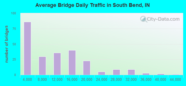
- 2,412,481Total average daily traffic
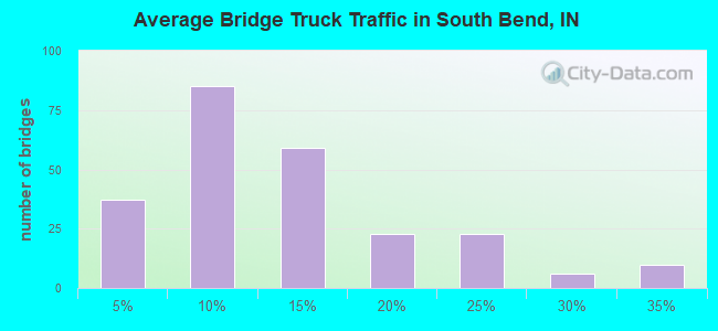
- 318,541Total average daily truck traffic
- National Bridge Inventory (NBI) Registered Bridges for South Bend
- No street view available for this location
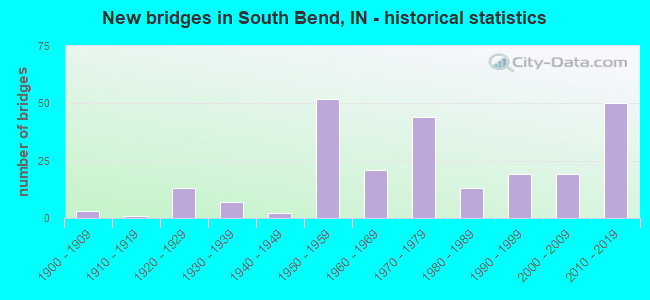
- New bridges - historical statistics
- 31900-1909
- 11910-1919
- 131920-1929
- 71930-1939
- 21940-1949
- 521950-1959
- 211960-1969
- 441970-1979
- 131980-1989
- 191990-1999
- 192000-2009
- 502010-2019
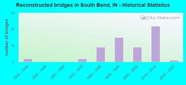
- Reconstructed bridges - Historical Statistics
- 21940-1949
- 01950-1959
- 01960-1969
- 21970-1979
- 91980-1989
- 151990-1999
- 92000-2009
- 222010-2019
- 12020-2022
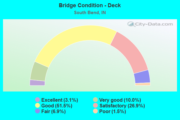
- Bridge Condition - Deck
- 3.1%Excellent
- 10.0%Very good
- 51.5%Good
- 26.9%Satisfactory
- 6.9%Fair
- 1.5%Poor
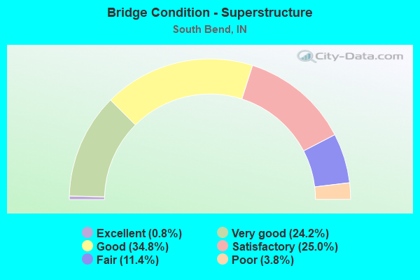
- Bridge Condition - Superstructure
- 0.8%Excellent
- 24.2%Very good
- 34.8%Good
- 25.0%Satisfactory
- 11.4%Fair
- 3.8%Poor
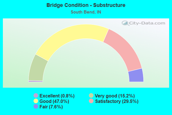
- Bridge Condition - Substructure
- 0.8%Excellent
- 15.2%Very good
- 47.0%Good
- 29.5%Satisfactory
- 7.6%Fair
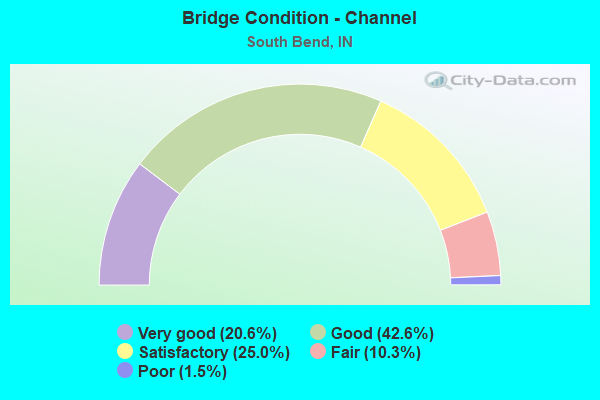
- Bridge Condition - Channel
- 20.6%Very good
- 42.6%Good
- 25.0%Satisfactory
- 10.3%Fair
- 1.5%Poor
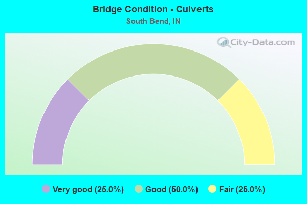
- Bridge Condition - Culverts
- 25.0%Very good
- 50.0%Good
- 25.0%Fair
Find on map >> Show street view
Structure Number: 1104, Location: 00.37 S SR 933 N JCT (Lat: 41.665289, Lng: -86.243300), Route carried "under" structure: State highway 23, Year Built: 1928, Structure Length: 0. m, Average Daily Traffic: 7,898 (year 2020), Truck Traffic: 4%, Features Intersected: SR 23 SB & SR 933 WB, Facility Carried by Structure: NS & GTW RRs
Minimum Vertical Clearance: 4.32m (14.17ft), Kilometerpoint: 37.626, Lanes under structure: 2, Material/Design: Steel continuous, Design/Construction: Girder and Floorbeam System, Length of Maximum Span: 14.6m (47.9ft)
Find on map >> Show street view
Structure Number: 1104, Location: 00.37 S SR 933 N JCT (Lat: 41.665289, Lng: -86.243300), Route carried "under" structure: State highway 23, Year Built: 1928, Structure Length: 0. m, Average Daily Traffic: 9,304 (year 2020), Truck Traffic: 4%, Features Intersected: SR 23 NB & SR 933 EB, Facility Carried by Structure: NS & GTW RRs
Minimum Vertical Clearance: 4.32m (14.17ft), Kilometerpoint: 37.626, Lanes under structure: 2, Material/Design: Steel continuous, Design/Construction: Girder and Floorbeam System, Length of Maximum Span: 14.6m (47.9ft)
Find on map >> Show street view
Structure Number: 11043, Location: 00.26 N SR 23 (Lat: 41.668781, Lng: -86.251831), Route carried "under" structure: State highway 933, Year Built: 1928, Structure Length: 0. m, Average Daily Traffic: 3,039 (year 2020), Truck Traffic: 5%, Features Intersected: SR 933 NB, Facility Carried by Structure: NS & GTW RRs
Minimum Vertical Clearance: 4.42m (14.50ft), Kilometerpoint: 1.577, Lanes under structure: 2, Material/Design: Steel, Design/Construction: Stringer/Multi-beam, Length of Maximum Span: 9.8m (32.2ft)
Find on map >> Show street view
Structure Number: 11043, Location: 00.26 N SR 23 (Lat: 41.668781, Lng: -86.251831), Route carried "under" structure: State highway 933, Year Built: 1928, Structure Length: 0. m, Average Daily Traffic: 4,726 (year 2020), Truck Traffic: 5%, Features Intersected: SR 933 SB, Facility Carried by Structure: NS & GTW RRs
Minimum Vertical Clearance: 4.42m (14.50ft), Kilometerpoint: 1.577, Lanes under structure: 2, Material/Design: Steel, Design/Construction: Stringer/Multi-beam, Length of Maximum Span: 9.8m (32.2ft)
Find on map >> Show street view
Structure Number: 4757, Location: 04.28 W US 31 (Lat: 41.747850, Lng: -86.409569), Route carried "under" structure: County highway , Year Built: 1956, Structure Length: 0. m, Average Daily Traffic: 143 (year 2004), Truck Traffic: 10%, Features Intersected: SYCAMORE RD, Facility Carried by Structure: I-90 EB
Minimum Vertical Clearance: 4.19m (13.75ft), Kilometerpoint: 0.000, Lanes on structure: 2, Lanes under structure: 2, Toll: On toll road, Material/Design: Steel, Design/Construction: Stringer/Multi-beam, Length of Maximum Span: 10.4m (34.1ft)
Find on map >> Show street view
Structure Number: 4758, Location: 04.28 W US 31 (Lat: 41.748081, Lng: -86.409569), Route carried "under" structure: County highway , Year Built: 1956, Structure Length: 0. m, Average Daily Traffic: 143 (year 2004), Truck Traffic: 10%, Features Intersected: SYCAMORE ROAD, Facility Carried by Structure: I-90 WB
Minimum Vertical Clearance: 4.22m (13.85ft), Kilometerpoint: 0.000, Lanes on structure: 2, Lanes under structure: 2, Toll: On toll road, Material/Design: Steel, Design/Construction: Stringer/Multi-beam, Length of Maximum Span: 10.4m (34.1ft)
Find on map >> Show street view
Structure Number: 4759, Location: 02.40 W US 31 (Lat: 41.732161, Lng: -86.380386), Route carried "under" structure: Interstate 90, Year Built: 1956, Structure Length: 0. m, Average Daily Traffic: 13,935 (year 2015), Truck Traffic: 10%, Features Intersected: I-90 EB, Facility Carried by Structure: QUINCE ROAD
Minimum Vertical Clearance: 5.05m (16.57ft), Kilometerpoint: 112.590, Lanes on structure: 2, Lanes under structure: 2, Toll: On toll road, Material/Design: Steel, Design/Construction: Stringer/Multi-beam, Length of Maximum Span: 21.5m (70.5ft)
Find on map >> Show street view
Structure Number: 4759, Location: 02.40 W US 31 (Lat: 41.732161, Lng: -86.380386), Route carried "under" structure: Interstate 90, Year Built: 1956, Structure Length: 0. m, Average Daily Traffic: 13,935 (year 2015), Truck Traffic: 10%, Features Intersected: I-90 WB, Facility Carried by Structure: QUINCE ROAD
Minimum Vertical Clearance: 5.05m (16.57ft), Kilometerpoint: 112.590, Lanes on structure: 2, Lanes under structure: 2, Toll: On toll road, Material/Design: Steel, Design/Construction: Stringer/Multi-beam, Length of Maximum Span: 21.5m (70.5ft)
Find on map >> Show street view
Structure Number: 476, Location: 01.88 W US 31 (Lat: 41.730531, Lng: -86.370658), Route carried "under" structure: Interstate 90, Year Built: 1956, Structure Length: 0. m, Average Daily Traffic: 13,935 (year 2015), Truck Traffic: 10%, Features Intersected: I-90 EB, Facility Carried by Structure: PRIMROSE ROAD
Minimum Vertical Clearance: 5.03m (16.50ft), Kilometerpoint: 113.427, Lanes on structure: 2, Lanes under structure: 2, Toll: On toll road, Material/Design: Steel, Design/Construction: Stringer/Multi-beam, Length of Maximum Span: 20.0m (65.6ft)
Find on map >> Show street view
Structure Number: 476, Location: 01.88 W US 31 (Lat: 41.730531, Lng: -86.370658), Route carried "under" structure: Interstate 90, Year Built: 1956, Structure Length: 0. m, Average Daily Traffic: 13,935 (year 2015), Truck Traffic: 10%, Features Intersected: I-90 WB, Facility Carried by Structure: PRIMROSE ROAD
Minimum Vertical Clearance: 5.03m (16.50ft), Kilometerpoint: 113.427, Lanes on structure: 2, Lanes under structure: 2, Toll: On toll road, Material/Design: Steel, Design/Construction: Stringer/Multi-beam, Length of Maximum Span: 20.0m (65.6ft)
Find on map >> Show street view
Structure Number: 4761, Location: 00.67 W US 31 (Lat: 41.730319, Lng: -86.347283), Route carried "under" structure: Interstate 90, Year Built: 2003, Structure Length: 0. m, Average Daily Traffic: 27,720 (year 2011), Truck Traffic: 10%, Features Intersected: I-90 EBL, Facility Carried by Structure: OLIVE ROAD
Minimum Vertical Clearance: 5.11m (16.77ft), Kilometerpoint: 115.374, Lanes on structure: 4, Lanes under structure: 4, Material/Design: Steel continuous, Design/Construction: Stringer/Multi-beam, Length of Maximum Span: 32.0m (105.0ft)
Find on map >> Show street view
Structure Number: 4761, Location: 00.67 W US 31 (Lat: 41.730319, Lng: -86.347283), Route carried "under" structure: Interstate 90, Year Built: 2003, Structure Length: 0. m, Average Daily Traffic: 27,720 (year 2011), Truck Traffic: 10%, Features Intersected: I-90 WBL, Facility Carried by Structure: OLIVE ROAD
Minimum Vertical Clearance: 5.11m (16.77ft), Kilometerpoint: 115.374, Lanes on structure: 4, Lanes under structure: 4, Material/Design: Steel continuous, Design/Construction: Stringer/Multi-beam, Length of Maximum Span: 32.0m (105.0ft)
Find on map >> Show street view
Structure Number: 4762, Location: 00.09 E US 31 (Lat: 41.730389, Lng: -86.333472), Route carried "under" structure: Interstate 90, Year Built: 1980, Structure Length: 0. m, Average Daily Traffic: 28,960 (year 2015), Truck Traffic: 34%, Features Intersected: I-90 EBL
Minimum Vertical Clearance: 4.85m (15.91ft), Kilometerpoint: 116.597, Lanes on structure: 2, Lanes under structure: 4, Toll: On toll road, Material/Design: Prestressed concrete continuous, Design/Construction: Stringer/Multi-beam, Length of Maximum Span: 25.3m (83.0ft)
Find on map >> Show street view
Structure Number: 4762, Location: 00.09 E US 31 (Lat: 41.730389, Lng: -86.333472), Route carried "under" structure: Interstate 90, Year Built: 1980, Structure Length: 0. m, Average Daily Traffic: 28,960 (year 2015), Truck Traffic: 34%, Features Intersected: I-90 WBL
Minimum Vertical Clearance: 4.85m (15.91ft), Kilometerpoint: 116.597, Lanes on structure: 2, Lanes under structure: 4, Toll: On toll road, Material/Design: Prestressed concrete continuous, Design/Construction: Stringer/Multi-beam, Length of Maximum Span: 25.3m (83.0ft)
Find on map >> Show street view
Structure Number: 4764, Location: 02.31 E US 31 (Lat: 41.722850, Lng: -86.292497), Route carried "under" structure: Interstate 90, Year Built: 1956, Structure Length: 0. m, Average Daily Traffic: 14,480 (year 2011), Truck Traffic: 10%, Features Intersected: I-90 EB, Facility Carried by Structure: BENDIX DRIVE NB
Minimum Vertical Clearance: 4.80m (15.75ft), Kilometerpoint: 120.170, Lanes on structure: 2, Lanes under structure: 2, Toll: On toll road, Material/Design: Steel, Design/Construction: Stringer/Multi-beam, Length of Maximum Span: 14.9m (48.9ft)
Find on map >> Show street view
Structure Number: 4764, Location: 02.31 E US 31 (Lat: 41.722850, Lng: -86.292497), Route carried "under" structure: Interstate 90, Year Built: 1956, Structure Length: 0. m, Average Daily Traffic: 14,480 (year 2011), Truck Traffic: 10%, Features Intersected: I-90 WB, Facility Carried by Structure: BENDIX DRIVE NB
Minimum Vertical Clearance: 4.88m (16.01ft), Kilometerpoint: 120.170, Lanes on structure: 2, Lanes under structure: 2, Toll: On toll road, Material/Design: Steel, Design/Construction: Stringer/Multi-beam, Length of Maximum Span: 14.9m (48.9ft)
Find on map >> Show street view
Structure Number: 4765, Location: 02.30 E US 31 (Lat: 41.722889, Lng: -86.292703), Route carried "under" structure: Interstate 90, Year Built: 1976, Structure Length: 0. m, Average Daily Traffic: 14,480 (year 2014), Truck Traffic: 10%, Features Intersected: BENDIX DR SB
Minimum Vertical Clearance: 4.88m (16.01ft), Kilometerpoint: 120.154, Lanes on structure: 2, Lanes under structure: 2, Toll: On toll road, Material/Design: Steel, Design/Construction: Stringer/Multi-beam, Length of Maximum Span: 19.8m (65.0ft)
Find on map >> Show street view
Structure Number: 4765, Location: 02.30 E US 31 (Lat: 41.722889, Lng: -86.292703), Route carried "under" structure: Interstate 90, Year Built: 1976, Structure Length: 0. m, Average Daily Traffic: 14,480 (year 2014), Truck Traffic: 10%, Features Intersected: I-90 EB/WB, Facility Carried by Structure: BENDIX DRIVE SB
Minimum Vertical Clearance: 4.83m (15.85ft), Kilometerpoint: 120.154, Lanes on structure: 2, Lanes under structure: 2, Toll: On toll road, Material/Design: Steel, Design/Construction: Stringer/Multi-beam, Length of Maximum Span: 19.8m (65.0ft)
Find on map >> Show street view
Structure Number: 4766, Location: 01.88 W SR 933 (Lat: 41.722311, Lng: -86.286042), Route carried "under" structure: Interstate 90, Year Built: 1994, Structure Length: 0. m, Average Daily Traffic: 14,480 (year 2014), Truck Traffic: 10%, Features Intersected: I-90 EB, Facility Carried by Structure: PORTAGE AVENUE
Minimum Vertical Clearance: 5.36m (17.59ft), Kilometerpoint: 120.636, Lanes on structure: 5, Lanes under structure: 2, Toll: On toll road, Material/Design: Steel continuous, Design/Construction: Stringer/Multi-beam, Length of Maximum Span: 36.3m (119.1ft)
Find on map >> Show street view
Structure Number: 4766, Location: 01.88 W SR 933 (Lat: 41.722311, Lng: -86.286042), Route carried "under" structure: Interstate 90, Year Built: 1994, Structure Length: 0. m, Average Daily Traffic: 14,480 (year 2014), Truck Traffic: 10%, Features Intersected: I-90 WB, Facility Carried by Structure: PORTAGE AVENUE
Minimum Vertical Clearance: 4.88m (16.01ft), Kilometerpoint: 120.636, Lanes on structure: 5, Lanes under structure: 2, Toll: On toll road, Material/Design: Steel continuous, Design/Construction: Stringer/Multi-beam, Length of Maximum Span: 36.3m (119.1ft)
Find on map >> Show street view
Structure Number: 4767, Location: 01.04 W SR 933 (Lat: 41.722361, Lng: -86.270492), Route carried "under" structure: City street , Year Built: 1956, Structure Length: 0. m, Average Daily Traffic: 1,194 (year 2004), Truck Traffic: 5%, Features Intersected: RIVERSIDE DRIVE NBL, Facility Carried by Structure: I-90 EB
Minimum Vertical Clearance: 4.98m (16.34ft), Kilometerpoint: 0.000, Lanes on structure: 2, Lanes under structure: 4, Toll: On toll road, Material/Design: Steel, Design/Construction: Stringer/Multi-beam, Length of Maximum Span: 12.5m (41.0ft)
Find on map >> Show street view
Structure Number: 4767, Location: 01.04 W SR 933 (Lat: 41.722361, Lng: -86.270492), Route carried "under" structure: City street , Year Built: 1956, Structure Length: 0. m, Average Daily Traffic: 1,194 (year 2004), Truck Traffic: 5%, Features Intersected: RIVERSIDE DRIVE SBL, Facility Carried by Structure: I-90 EB
Minimum Vertical Clearance: 4.98m (16.34ft), Kilometerpoint: 0.000, Lanes on structure: 2, Lanes under structure: 4, Toll: On toll road, Material/Design: Steel, Design/Construction: Stringer/Multi-beam, Length of Maximum Span: 12.5m (41.0ft)
Find on map >> Show street view
Structure Number: 4768, Location: 01.04 W SR 933 (Lat: 41.722600, Lng: -86.270553), Route carried "under" structure: City street , Year Built: 1956, Structure Length: 0. m, Average Daily Traffic: 2,251 (year 2011), Truck Traffic: 5%, Features Intersected: RIVERSIDE DRIVE NBL, Facility Carried by Structure: I-90 WB
Minimum Vertical Clearance: 4.85m (15.91ft), Kilometerpoint: 0.000, Lanes on structure: 2, Lanes under structure: 4, Toll: On toll road, Material/Design: Steel, Design/Construction: Stringer/Multi-beam, Length of Maximum Span: 12.5m (41.0ft)
Find on map >> Show street view
Structure Number: 4768, Location: 01.04 W SR 933 (Lat: 41.722600, Lng: -86.270553), Route carried "under" structure: City street , Year Built: 1956, Structure Length: 0. m, Average Daily Traffic: 2,251 (year 2004), Truck Traffic: 5%, Features Intersected: RIVERSIDE DRIVE SBL, Facility Carried by Structure: I-90 WB
Minimum Vertical Clearance: 4.85m (15.91ft), Kilometerpoint: 0.000, Lanes on structure: 2, Lanes under structure: 4, Toll: On toll road, Material/Design: Steel, Design/Construction: Stringer/Multi-beam, Length of Maximum Span: 12.5m (41.0ft)
Find on map >> Show street view
Structure Number: 4771, Location: 00.13 W SR 933 (Lat: 41.722511, Lng: -86.255797), Route carried "under" structure: Ramp Interstate 90, Year Built: 1956, Structure Length: 0. m, Average Daily Traffic: 1,610 (year 2015), Truck Traffic: 5%, Features Intersected: OFF RAMP > SOUTH BEND
Minimum Vertical Clearance: 4.85m (15.91ft), Kilometerpoint: 0.000, Lanes on structure: 2, Lanes under structure: 1, Toll: On toll road, Material/Design: Steel, Design/Construction: Stringer/Multi-beam, Length of Maximum Span: 18.3m (60.0ft)
Find on map >> Show street view
Structure Number: 4771, Location: 00.13 W SR 933 (Lat: 41.722511, Lng: -86.255789), Route carried "under" structure: Ramp Interstate 90, Year Built: 1956, Structure Length: 0. m, Average Daily Traffic: 2,260 (year 2015), Truck Traffic: 5%, Features Intersected: SOUTH BEND > I-90 WB
Minimum Vertical Clearance: 4.85m (15.91ft), Kilometerpoint: 0.000, Lanes on structure: 2, Lanes under structure: 1, Toll: On toll road, Material/Design: Steel, Design/Construction: Stringer/Multi-beam, Length of Maximum Span: 18.3m (60.0ft)
Find on map >> Show street view
Structure Number: 4772, Location: 00.13 W SR 933 (Lat: 41.722761, Lng: -86.255858), Route carried "under" structure: Ramp Interstate , Year Built: 1956, Structure Length: 0. m, Average Daily Traffic: 735 (year 2004), Truck Traffic: 5%, Features Intersected: Ramp to I-90(South Bend), Facility Carried by Structure: I-90 WB
Minimum Vertical Clearance: 5.03m (16.50ft), Kilometerpoint: 0.000, Lanes on structure: 3, Lanes under structure: 2, Toll: On toll road, Material/Design: Steel, Design/Construction: Stringer/Multi-beam, Length of Maximum Span: 18.3m (60.0ft)
Find on map >> Show street view
Structure Number: 4779, Location: 00.88 E SR 933 (Lat: 41.716569, Lng: -86.235778), Route carried "under" structure: County highway , Year Built: 1956, Structure Length: 0. m, Average Daily Traffic: 5,562 (year 2014), Truck Traffic: 5%, Features Intersected: JUNIPER RD, Facility Carried by Structure: I-90 EB
Minimum Vertical Clearance: 4.32m (14.17ft), Kilometerpoint: 0.000, Lanes on structure: 2, Lanes under structure: 2, Material/Design: Steel continuous, Design/Construction: Stringer/Multi-beam, Length of Maximum Span: 10.1m (33.1ft)
Find on map >> Show street view
Structure Number: 478, Location: 00.88 E SR 933 (Lat: 41.716789, Lng: -86.235778), Route carried "under" structure: County highway , Year Built: 1956, Structure Length: 0. m, Average Daily Traffic: 5,662 (year 2011), Truck Traffic: 5%, Features Intersected: JUNIPER RD, Facility Carried by Structure: I-90 WB
Minimum Vertical Clearance: 4.37m (14.34ft), Kilometerpoint: 0.000, Lanes on structure: 2, Lanes under structure: 2, Material/Design: Steel continuous, Design/Construction: Stringer/Multi-beam, Length of Maximum Span: 10.1m (33.1ft)
Find on map >> Show street view
Structure Number: 47805, Location: 01.05 W SR 23 (Lat: 41.716000, Lng: -86.216933), Route carried "under" structure: Interstate 90, Year Built: 1979, Structure Length: 0. m, Average Daily Traffic: 14,460 (year 2011), Truck Traffic: 5%, Features Intersected: I-90 EB, Facility Carried by Structure: IRONWOOD ROAD SB
Minimum Vertical Clearance: 5.05m (16.57ft), Kilometerpoint: 126.639, Lanes on structure: 2, Lanes under structure: 2, Toll: On toll road, Material/Design: Steel continuous, Design/Construction: Stringer/Multi-beam, Length of Maximum Span: 20.0m (65.6ft)
Find on map >> Show street view
Structure Number: 47805, Location: 01.05 W SR 23 (Lat: 41.716000, Lng: -86.216933), Route carried "under" structure: Interstate 90, Year Built: 1979, Structure Length: 0. m, Average Daily Traffic: 14,460 (year 2011), Truck Traffic: 5%, Features Intersected: I-90 WB, Facility Carried by Structure: IRONWOOD ROAD SB
Minimum Vertical Clearance: 5.05m (16.57ft), Kilometerpoint: 126.639, Lanes on structure: 2, Lanes under structure: 2, Toll: On toll road, Material/Design: Steel continuous, Design/Construction: Stringer/Multi-beam, Length of Maximum Span: 20.0m (65.6ft)
Find on map >> Show street view
Structure Number: 4781, Location: 01.06 W SR 23 (Lat: 41.716000, Lng: -86.216842), Route carried "under" structure: Interstate 90, Year Built: 1956, Structure Length: 0. m, Average Daily Traffic: 14,480 (year 2015), Truck Traffic: 5%, Features Intersected: I-90 EB, Facility Carried by Structure: IRONWOOD ROAD NB
Minimum Vertical Clearance: 4.95m (16.24ft), Kilometerpoint: 126.655, Lanes on structure: 2, Lanes under structure: 2, Toll: On toll road, Material/Design: Steel, Design/Construction: Stringer/Multi-beam, Length of Maximum Span: 20.0m (65.6ft)
Find on map >> Show street view
Structure Number: 4781, Location: 01.06 W SR 23 (Lat: 41.716000, Lng: -86.216842), Route carried "under" structure: Interstate 90, Year Built: 1956, Structure Length: 0. m, Average Daily Traffic: 14,480 (year 2015), Truck Traffic: 5%, Features Intersected: I-90 WB, Facility Carried by Structure: IRONWOOD ROAD NB
Minimum Vertical Clearance: 4.95m (16.24ft), Kilometerpoint: 126.655, Lanes on structure: 2, Lanes under structure: 2, Toll: On toll road, Material/Design: Steel, Design/Construction: Stringer/Multi-beam, Length of Maximum Span: 20.0m (65.6ft)
Find on map >> Show street view
Structure Number: 4782, Location: 02.92 E SR 933 (Lat: 41.716039, Lng: -86.196672), Route carried "under" structure: State highway 23, Year Built: 1956, Structure Length: 0. m, Average Daily Traffic: 26,420 (year 2011), Truck Traffic: 5%, Features Intersected: SR 23/EDWARDSBURG RD NBL, Facility Carried by Structure: I-90 EB
Minimum Vertical Clearance: 4.40m (14.44ft), Kilometerpoint: 45.400, Lanes on structure: 2, Lanes under structure: 4, Toll: On toll road, Material/Design: Steel, Design/Construction: Stringer/Multi-beam, Length of Maximum Span: 18.3m (60.0ft)
Find on map >> Show street view
Structure Number: 4782, Location: 02.92 E SR 933 (Lat: 41.716039, Lng: -86.196672), Route carried "under" structure: State highway 90, Year Built: 1956, Structure Length: 0. m, Average Daily Traffic: 26,420 (year 2011), Truck Traffic: 5%, Features Intersected: SR 23/EDWARDSBURG RD SBL
Minimum Vertical Clearance: 4.40m (14.44ft), Kilometerpoint: 45.400, Lanes on structure: 2, Lanes under structure: 4, Toll: On toll road, Material/Design: Steel, Design/Construction: Stringer/Multi-beam, Length of Maximum Span: 18.3m (60.0ft)
Find on map >> Show street view
Structure Number: 4783, Location: 02.92 E SR 933 (Lat: 41.716250, Lng: -86.196450), Route carried "under" structure: State highway 23, Year Built: 1956, Structure Length: 0. m, Average Daily Traffic: 26,420 (year 2011), Truck Traffic: 5%, Features Intersected: SR 23/EDWARDSBURG RD SBL, Facility Carried by Structure: I-90 WB
Minimum Vertical Clearance: 4.75m (15.58ft), Kilometerpoint: 45.094, Lanes on structure: 2, Lanes under structure: 4, Toll: On toll road, Material/Design: Steel, Design/Construction: Stringer/Multi-beam, Length of Maximum Span: 18.3m (60.0ft)
Find on map >> Show street view
Structure Number: 4783, Location: 02.92 E SR 933 (Lat: 41.716250, Lng: -86.196450), Route carried "under" structure: State highway 23, Year Built: 1956, Structure Length: 0. m, Average Daily Traffic: 26,420 (year 2011), Truck Traffic: 5%, Features Intersected: SR 23/EDWARDSBURG RD NBL, Facility Carried by Structure: I-90 WB
Minimum Vertical Clearance: 4.75m (15.58ft), Kilometerpoint: 45.094, Lanes on structure: 2, Lanes under structure: 4, Toll: On toll road, Material/Design: Steel, Design/Construction: Stringer/Multi-beam, Length of Maximum Span: 18.3m (60.0ft)
Find on map >> Show street view
Structure Number: 4785, Location: 01.74 E SR 23 (Lat: 41.719289, Lng: -86.163414), Route carried "under" structure: Interstate 90, Year Built: 1956, Structure Length: 0. m, Average Daily Traffic: 28,960 (year 2015), Truck Traffic: 34%, Features Intersected: I-90 WBL, Facility Carried by Structure: FIR ROAD
Minimum Vertical Clearance: 4.83m (15.85ft), Kilometerpoint: 131.162, Lanes on structure: 2, Lanes under structure: 4, Material/Design: Steel, Design/Construction: Stringer/Multi-beam, Length of Maximum Span: 22.9m (75.1ft)
Find on map >> Show street view
Structure Number: 4785, Location: 01.74 E SR 23 (Lat: 41.719289, Lng: -86.163414), Route carried "under" structure: Interstate 90, Year Built: 1956, Structure Length: 0. m, Average Daily Traffic: 28,960 (year 2015), Truck Traffic: 34%, Features Intersected: I-90 EBL, Facility Carried by Structure: FIR ROAD
Minimum Vertical Clearance: 4.83m (15.85ft), Kilometerpoint: 131.162, Lanes on structure: 2, Lanes under structure: 4, Material/Design: Steel, Design/Construction: Stringer/Multi-beam, Length of Maximum Span: 22.9m (75.1ft)
Find on map >> Show street view
Structure Number: 75, Location: 00.87 E US-31 (Lat: 41.624589, Lng: -86.234764), Route carried "under" structure: City street , Year Built: 1991, Structure Length: 0. m, Average Daily Traffic: 12,936 (year 2018), Truck Traffic: 2%, Features Intersected: MIAMI HIGHWAY, Facility Carried by Structure: US 20
Minimum Vertical Clearance: 4.95m (16.24ft), Kilometerpoint: 0.000, Lanes on structure: 4, Lanes under structure: 4, Material/Design: Prestressed concrete continuous, Design/Construction: Stringer/Multi-beam, Length of Maximum Span: 22.3m (73.2ft)
Find on map >> Show street view
Structure Number: 76828, Location: 00.99 E SR 23 (Lat: 41.631961, Lng: -86.282744), Route carried "under" structure: US 20, Year Built: 2009, Structure Length: 0. m, Average Daily Traffic: 16,800 (year 2009), Truck Traffic: 16%, Features Intersected: US-20 EBL, Facility Carried by Structure: LOCUST ROAD
Minimum Vertical Clearance: 5.05m (16.57ft), Kilometerpoint: 26.586, Lanes on structure: 2, Lanes under structure: 4, Material/Design: Prestressed concrete continuous, Design/Construction: Tee Beam, Length of Maximum Span: 28.0m (91.9ft)
Find on map >> Show street view
Structure Number: 76828, Location: 00.99 E SR 23 (Lat: 41.631961, Lng: -86.282744), Route carried "under" structure: US 20, Year Built: 2009, Structure Length: 0. m, Average Daily Traffic: 16,800 (year 2009), Truck Traffic: 16%, Features Intersected: US-20 WBL, Facility Carried by Structure: LOCUST ROAD
Minimum Vertical Clearance: 5.05m (16.57ft), Kilometerpoint: 26.586, Lanes on structure: 2, Lanes under structure: 4, Material/Design: Prestressed concrete continuous, Design/Construction: Tee Beam, Length of Maximum Span: 28.0m (91.9ft)
Find on map >> Show street view
Structure Number: 7683, Location: 03.07 S SR-933 (Lat: 41.641119, Lng: -86.297683), Route carried "under" structure: US 20, Year Built: 2004, Structure Length: 0. m, Average Daily Traffic: 13,750 (year 2010), Truck Traffic: 27%, Features Intersected: US 20(US-31) WBL, Facility Carried by Structure: SR 3
Minimum Vertical Clearance: 5.08m (16.67ft), Kilometerpoint: 24.993, Lanes on structure: 5, Lanes under structure: 4, Material/Design: Prestressed concrete continuous, Design/Construction: Tee Beam, Length of Maximum Span: 30.8m (101.0ft)
Find on map >> Show street view
Structure Number: 7683, Location: 03.07 S SR-933 (Lat: 41.641119, Lng: -86.297683), Route carried "under" structure: US 20, Year Built: 2004, Structure Length: 0. m, Average Daily Traffic: 13,750 (year 2010), Truck Traffic: 27%, Features Intersected: US-20(US-31) EBL, Facility Carried by Structure: SR 3
Minimum Vertical Clearance: 5.08m (16.67ft), Kilometerpoint: 24.993, Lanes on structure: 5, Lanes under structure: 4, Material/Design: Prestressed concrete continuous, Design/Construction: Tee Beam, Length of Maximum Span: 30.8m (101.0ft)
Find on map >> Show street view
Structure Number: 79654, Location: 01.35 E SR 23 (Lat: 41.628700, Lng: -86.277756), Route carried "under" structure: US 20, Year Built: 2011, Structure Length: 0. m, Average Daily Traffic: 16,120 (year 2008), Truck Traffic: 23%, Features Intersected: IRELAND RD
Minimum Vertical Clearance: 5.54m (18.18ft), Kilometerpoint: 27.166, Lanes on structure: 4, Lanes under structure: 2, Material/Design: Prestressed concrete continuous, Design/Construction: Stringer/Multi-beam, Length of Maximum Span: 20.2m (66.3ft)
Find on map >> Show street view
Structure Number: 79654, Location: 01.35 E SR 23 (Lat: 41.628700, Lng: -86.277756), Route carried "under" structure: US 20, Year Built: 2011, Structure Length: 0. m, Average Daily Traffic: 16,120 (year 2008), Truck Traffic: 23%, Features Intersected: IRELAND RD
Minimum Vertical Clearance: 5.13m (16.83ft), Kilometerpoint: 27.166, Lanes on structure: 4, Lanes under structure: 2, Material/Design: Prestressed concrete continuous, Design/Construction: Stringer/Multi-beam, Length of Maximum Span: 20.2m (66.3ft)
Find on map >> Show street view
Structure Number: 7968, Location: 0.260 S US 20 (Lat: 41.589789, Lng: -86.260231), Route carried "under" structure: US 31, Year Built: 2014, Structure Length: 0. m, Average Daily Traffic: 8,974 (year 2020), Truck Traffic: 19%, Features Intersected: US 31 NB, Facility Carried by Structure: DIXIE HWY
Minimum Vertical Clearance: 5.18m (16.99ft), Kilometerpoint: 391.473, Lanes on structure: 2, Lanes under structure: 5, Material/Design: Prestressed concrete, Design/Construction: Tee Beam, Length of Maximum Span: 45.1m (148.0ft)
Find on map >> Show street view
Structure Number: 79682, Location: 00.00 SW US 20 (Lat: 41.535369, Lng: -86.249639), Route carried "under" structure: State highway 4, Year Built: 2014, Structure Length: 0. m, Average Daily Traffic: 2,077 (year 2020), Truck Traffic: 7%, Features Intersected: US 31 NB
Minimum Vertical Clearance: 4.82m (15.81ft), Kilometerpoint: 385.132, Lanes on structure: 2, Lanes under structure: 4, Material/Design: Prestressed concrete, Design/Construction: Tee Beam, Length of Maximum Span: 35.4m (116.1ft)
Find on map >> Show street view
Structure Number: 79684, Location: 00.00 SW US 20 (Lat: 41.535361, Lng: -86.250075), Route carried "under" structure: State highway 4, Year Built: 2014, Structure Length: 0. m, Average Daily Traffic: 4,070 (year 2008), Truck Traffic: 10%, Features Intersected: US 31 SB
Minimum Vertical Clearance: 4.82m (15.81ft), Kilometerpoint: 385.132, Lanes on structure: 2, Lanes under structure: 4, Material/Design: Prestressed concrete, Design/Construction: Tee Beam, Length of Maximum Span: 35.4m (116.1ft)
Find on map >> Show street view
Structure Number: 79686, Location: 0.260 S US 20 (Lat: 41.589789, Lng: -86.260231), Route carried "under" structure: County highway , Year Built: 2014, Structure Length: 0. m, Average Daily Traffic: 30,000 (year 2008), Truck Traffic: 10%, Features Intersected: US 31 SB, Facility Carried by Structure: DIXIE HWY
Minimum Vertical Clearance: 5.18m (16.99ft), Kilometerpoint: 391.473, Lanes on structure: 2, Lanes under structure: 5, Material/Design: Prestressed concrete, Design/Construction: Tee Beam, Length of Maximum Span: 45.1m (148.0ft)
Find on map >> Show street view
Structure Number: 79688, Location: 02.24 SW US 20 (Lat: 41.593819, Lng: -86.264100), Route carried "under" structure: City street , Year Built: 2012, Structure Length: 0. m, Average Daily Traffic: 185 (year 2020), Truck Traffic: 21%, Features Intersected: US 31 NB, Facility Carried by Structure: ROOSEVELT RD
Minimum Vertical Clearance: 5.94m (19.49ft), Kilometerpoint: 0.000, Lanes on structure: 2, Lanes under structure: 2, Material/Design: Prestressed concrete, Design/Construction: Stringer/Multi-beam, Length of Maximum Span: 23.3m (76.4ft)
Find on map >> Show street view
Structure Number: 7969, Location: 02.24 SW US 20 (Lat: 41.593900, Lng: -86.264586), Route carried "under" structure: City street , Year Built: 2012, Structure Length: 0. m, Average Daily Traffic: 1,034 (year 2010), Truck Traffic: 5%, Features Intersected: US 31 SB, Facility Carried by Structure: ROOSEVELT RD
Minimum Vertical Clearance: 5.94m (19.49ft), Kilometerpoint: 391.779, Lanes on structure: 2, Lanes under structure: 2, Material/Design: Prestressed concrete, Design/Construction: Stringer/Multi-beam, Length of Maximum Span: 23.3m (76.4ft)
Find on map >> Show street view
Structure Number: 79844, Location: 02.80 N SR 4 (Lat: 41.575489, Lng: -86.248611), Route carried "under" structure: US 31, Year Built: 2014, Structure Length: 0. m, Average Daily Traffic: 18,974 (year 2015), Truck Traffic: 23%, Features Intersected: US 31 SB, Facility Carried by Structure: MILLER ROAD
Minimum Vertical Clearance: 5.24m (17.19ft), Kilometerpoint: 389.622, Lanes on structure: 2, Lanes under structure: 4, Material/Design: Concrete continuous, Design/Construction: Stringer/Multi-beam, Length of Maximum Span: 31.5m (103.3ft)
Find on map >> Show street view
Structure Number: 79844, Location: 02.80 N SR 4 (Lat: 41.575489, Lng: -86.248611), Route carried "under" structure: US 31, Year Built: 2014, Structure Length: 0. m, Average Daily Traffic: 18,974 (year 2015), Truck Traffic: 23%, Features Intersected: US 31 NB, Facility Carried by Structure: MILLER ROAD
Minimum Vertical Clearance: 5.24m (17.19ft), Kilometerpoint: 389.622, Lanes on structure: 2, Lanes under structure: 4, Material/Design: Concrete continuous, Design/Construction: Stringer/Multi-beam, Length of Maximum Span: 31.5m (103.3ft)
Find on map >> Show street view
Structure Number: 79848, Location: 01.10 S US 20 (Lat: 41.608397, Lng: -86.256811), Route carried "under" structure: County highway , Year Built: 2014, Structure Length: 0. m, Average Daily Traffic: 40,520 (year 2012), Truck Traffic: 10%, Features Intersected: KERN ROAD, Facility Carried by Structure: US 31
Minimum Vertical Clearance: 5.51m (18.08ft), Kilometerpoint: 0.000, Lanes on structure: 4, Lanes under structure: 4, Material/Design: Prestressed concrete continuous, Design/Construction: Stringer/Multi-beam, Length of Maximum Span: 57.9m (190.0ft)
Find on map >> Show street view
Structure Number: 7985, Location: 1.0 SW US 20 (Lat: 41.364000, Lng: -86.151800), Route carried "under" structure: City street , Year Built: 2014, Structure Length: 0. m, Average Daily Traffic: 1,993 (year 2020), Truck Traffic: 8%, Features Intersected: Main Street, Facility Carried by Structure: US 31 NB
Minimum Vertical Clearance: 4.66m (15.29ft), Kilometerpoint: 393.903, Lanes on structure: 2, Lanes under structure: 2, Material/Design: Prestressed concrete, Design/Construction: Tee Beam, Length of Maximum Span: 22.4m (73.5ft)
Find on map >> Show street view
Structure Number: 79852, Location: 01.00 SW US 20 (Lat: 41.611300, Lng: -86.254989), Route carried "under" structure: City street , Year Built: 2014, Structure Length: 0. m, Average Daily Traffic: 1,000 (year 2012), Truck Traffic: 3%, Features Intersected: Main Street, Facility Carried by Structure: US 31 SB
Minimum Vertical Clearance: 5.00m (16.40ft), Kilometerpoint: 393.903, Lanes on structure: 2, Lanes under structure: 2, Material/Design: Prestressed concrete, Design/Construction: Tee Beam, Length of Maximum Span: 26.8m (87.9ft)
Find on map >> Show street view
Structure Number: 79854, Location: 01.00 SW US 20 (Lat: 41.611111, Lng: -86.255000), Route carried "under" structure: City street , Year Built: 2014, Structure Length: 0. m, Average Daily Traffic: 1,993 (year 2020), Truck Traffic: 3%, Features Intersected: Main Street, Facility Carried by Structure: US 31 NB On-Ramp
Minimum Vertical Clearance: 4.60m (15.09ft), Kilometerpoint: 393.903, Lanes on structure: 1, Lanes under structure: 2, Material/Design: Prestressed concrete, Design/Construction: Tee Beam, Length of Maximum Span: 21.2m (69.6ft)
Find on map >> Show street view
Structure Number: 79856, Location: 01.00 SW US 20 (Lat: 41.611111, Lng: -86.255000), Route carried "under" structure: City street , Year Built: 2014, Structure Length: 0. m, Average Daily Traffic: 1,000 (year 2012), Truck Traffic: 3%, Features Intersected: Main Street, Facility Carried by Structure: US 31 SB Off-Ramp
Minimum Vertical Clearance: 30+ m (98+ ft), Kilometerpoint: 393.903, Lanes on structure: 1, Lanes under structure: 2, Material/Design: Prestressed concrete, Design/Construction: Tee Beam, Length of Maximum Span: 30.8m (101.0ft)
Find on map >> Show street view
Structure Number: 79858, Location: 00.10 S US 20 (Lat: 41.621703, Lng: -86.251781), Route carried "under" structure: US 31, Year Built: 2014, Structure Length: 0. m, Average Daily Traffic: 15,000 (year 2010), Truck Traffic: 5%, Features Intersected: JACKSON RD
Minimum Vertical Clearance: 6.65m (21.82ft), Kilometerpoint: 395.432, Lanes on structure: 2, Lanes under structure: 3, Material/Design: Steel continuous, Design/Construction: Stringer/Multi-beam, Length of Maximum Span: 65.8m (215.9ft)
Find on map >> Show street view
Structure Number: 79888, Location: 0.26 E US 31 (Lat: 41.624131, Lng: -86.246381), Route carried "under" structure: US 20, Year Built: 2014, Structure Length: 0. m, Average Daily Traffic: 17,025 (year 2015), Truck Traffic: 22%, Features Intersected: US 20 WB, Facility Carried by Structure: FELLOWS STREET
Minimum Vertical Clearance: 5.21m (17.09ft), Kilometerpoint: 127.347, Lanes on structure: 2, Lanes under structure: 4, Material/Design: Steel continuous, Design/Construction: Stringer/Multi-beam, Length of Maximum Span: 52.1m (170.9ft)
Find on map >> Show street view
Structure Number: 79888, Location: 0.26 E US 31 (Lat: 41.624131, Lng: -86.246381), Route carried "under" structure: US 20, Year Built: 2014, Structure Length: 0. m, Average Daily Traffic: 17,670 (year 2015), Truck Traffic: 22%, Features Intersected: US 20 EB, Facility Carried by Structure: FELLOWS STREET
Minimum Vertical Clearance: 5.21m (17.09ft), Kilometerpoint: 127.347, Lanes on structure: 2, Lanes under structure: 4, Material/Design: Steel continuous, Design/Construction: Stringer/Multi-beam, Length of Maximum Span: 52.1m (170.9ft)
Find on map >> Show street view
Structure Number: 80428, Location: 00.50 SW US 20 (Lat: 41.616619, Lng: -86.252328), Route carried "under" structure: US 31, Year Built: 2014, Structure Length: 0. m, Average Daily Traffic: 12,255 (year 2020), Truck Traffic: 15%, Features Intersected: US 31 NBL, Facility Carried by Structure: JOHNSON ROAD
Minimum Vertical Clearance: 5.16m (16.93ft), Kilometerpoint: 393.984, Lanes on structure: 2, Lanes under structure: 3, Material/Design: Prestressed concrete continuous, Design/Construction: Tee Beam, Length of Maximum Span: 30.1m (98.8ft)
Find on map >> Show street view
Structure Number: 80428, Location: 00.50 SW US 20 (Lat: 41.616619, Lng: -86.252328), Route carried "under" structure: US 31, Year Built: 2014, Structure Length: 0. m, Average Daily Traffic: 12,224 (year 2020), Truck Traffic: 15%, Features Intersected: US 31 SBL, Facility Carried by Structure: JOHNSON ROAD
Minimum Vertical Clearance: 5.31m (17.42ft), Kilometerpoint: 393.984, Lanes on structure: 2, Lanes under structure: 3, Material/Design: Prestressed concrete continuous, Design/Construction: Tee Beam, Length of Maximum Span: 30.1m (98.8ft)
Find on map >> Show street view
Structure Number: 7100088, Location: 00.10 N SR 933 (Lat: 41.659731, Lng: -86.225525), Route carried "under" structure: City street , Year Built: 1929, Structure Length: 0. m, Average Daily Traffic: 2,533 (year 2018), Truck Traffic: 2%, Features Intersected: NORTHSIDE BLVD, Facility Carried by Structure: TWYCKENHAM DR
Minimum Vertical Clearance: 5.18m (16.99ft), Kilometerpoint: 0.000, Lanes on structure: 4, Lanes under structure: 2, Material/Design: Concrete, Design/Construction: Arch - Deck, Length of Maximum Span: 35.1m (115.2ft)
Find on map >> Show street view
Structure Number: 71001, Location: 00.45 N FILLMORE ROAD (Lat: 41.686281, Lng: -86.322556), Route carried "under" structure: City street 824, Year Built: 1970, Structure Length: 0. m, Average Daily Traffic: 463 (year 2018), Truck Traffic: 7%, Features Intersected: ARDMORE TRAIL, Facility Carried by Structure: MAYFLOWER RD
Minimum Vertical Clearance: 4.12m (13.52ft), Kilometerpoint: 0.000, Lanes on structure: 2, Lanes under structure: 2, Material/Design: Prestressed concrete, Design/Construction: Box Beam or Girders - Multiple, Length of Maximum Span: 11.9m (39.0ft)
Find on map >> Show street view
Structure Number: 7100146, Location: 00.50 SW US 20 (Lat: 41.616864, Lng: -86.253911), Route carried "under" structure: City street , Year Built: 2016, Structure Length: 0. m, Average Daily Traffic: 1,000 (year 2012), Truck Traffic: 5%, Features Intersected: MAIN ST, Facility Carried by Structure: JOHNSON RD
Minimum Vertical Clearance: 4.66m (15.29ft), Kilometerpoint: 408.274, Lanes on structure: 2, Lanes under structure: 2, Material/Design: Prestressed concrete, Design/Construction: Tee Beam, Length of Maximum Span: 19.9m (65.3ft)